background - transform 66 - outside the beltway
TRANSCRIPT
2
The Federal Highway Administration (FHWA) has reviewed the Virginia Department of Transportation’s (VDOT) June 20, 2016 letter requesting a Tier 2 Finding of No Significant Impact, the Tier 2 Final Environmental Assessment (Final EA), the comments from the 2015 Public Hearings, and other supporting documentation.1 In accordance with 40 CFR 1508.13, this Tier 2 Finding of No Significant Impact briefly presents the reasons why the project will not have a significant impact on the human environment.
Background
Tier 1 On November 20, 2013, FHWA approved the Tier 1 Final Environmental Impact Statement (FEIS) and the Tier 1 Record of Decision (ROD) for the Interstate 66 (I-66) Corridor from US 15 to Interstate 495 (I-495) in Fairfax and Prince William Counties, Virginia. The Tier 1 FEIS studied potential multimodal improvements that could address existing and future transportation needs in the I-66 corridor between US 15 and I-495. During the Tier 1 study, VDOT and the Virginia Department of Rail and Public Transportation (DRPT) evaluated 10 improvement concepts that would increase capacity, provide multimodal travel options, improve individual interchanges, and address safety and operations. The 10 concepts were:
• General Purpose Lanes: Construction of additional highway lanes open to all traffic. • Managed Lanes: Conversion of the existing high-occupancy vehicle (HOV) lane into
either a one- or two-lane (in each direction) facility that would operate as a high-occupancy toll facility where only high-occupancy vehicles would be exempt from paying a toll.
• Metrorail Extension: Metrorail service extending west from Vienna to either Centreville or Haymarket.
• Light Rail Transit: Light rail service extending west from Vienna to either Centreville or Haymarket.
• Bus Rapid Transit: Separate guideway bus rapid transit extending west from Vienna to Haymarket; service could extend east of Vienna.
• Virginia Railway Express (VRE) Extension: Extension of existing VRE service from Manassas to Haymarket.
• Improve Spot Locations/Chokepoints: Improvements that address operations constraints at discrete locations (chokepoints) such as individual interchanges or specific junction points within the interchanges (i.e., merge, diverge, or weaving areas).
• Intermodal Connectivity: Availability of a full range of travel modes within the corridor, as well as availability and functionality of connections between travel modes.
• Safety Improvements: Safety improvements that address both location-specific and corridor-wide safety concerns.
• Transportation Communication and Technology: Continued enhancements to Intelligent Transportation Systems (ITS) technology for all modes in the corridor, including traveler information, corridor and incident management, and transit technology.
1 The letter and the Tier 2 Final EA are hereby incorporated by reference into this Tier 2 Finding of No Significant Impact.
3
The decisions enumerated in the Tier 1 ROD included the following:
• All 10 improvement concepts were advanced from Tier 1. • The general location for studying future highway and transit improvements is within the
existing I-66 corridor, with the exception of VRE improvements for which the general location is the existing VRE alignment. Each of the improvement concepts would be located within the corridor in which it currently exists, rather than within new-location corridors.
• No specific individual projects associated with the Tier 1 FEIS were identified in the Tier 1 ROD; rather, the Tier 1 ROD allowed the Commonwealth of Virginia to identify individual Tier 2 projects for subsequent study.
• The consideration of tolls as a funding source was advanced for subsequent study. Tier 2 VDOT, in cooperation with DRPT and local governments, identified a multimodal combination of improvements derived from the Tier 1 improvement concepts for Tier 2 study and further development. The elements of this Tier 2 project are:
• Three regular (general purpose) lanes in each direction (the same as the existing condition).
• Two express lanes in each direction (the existing HOV lane would be converted to an express lane, and one new express lane would be constructed).
• High-frequency bus service with predictable travel times, along with additional park-and-ride lots.
• Direct access between the express lanes and new or expanded commuter park-and-ride lots.
• Bicycle and pedestrian improvements. • ITS technology.
The elements of this Tier 2 project represent a combination of Tier 1 build concepts over the 25-mile-long corridor. Specifically, the proposed project includes improving spot locations and chokepoints, providing for intermodal connectivity, providing safety improvements, enhancing transportation communication and technology, and adding capacity while also expanding travel choices. In addition to the infrastructure elements listed above, park-and-ride lots, ingress and egress points to and from the express lanes, and new and expanded transit services would be included to support enhanced point-to-point commuter services in expanded peak periods in the express lanes to provide additional multimodal options in the corridor. The express lanes would connect to the existing express lanes on I-495 to provide a seamlessly connected network of express lanes between the two interstate highways. In addition, the I-66 express lanes would provide a direct connection for buses and HOV to I-66 east of I-495. Direct access ramps also are proposed to connect the I-66 express lanes to and from the general purpose lanes and/or crossroads and interchanges. FHWA approved the Tier 2 Draft Environmental Assessment (Draft EA) on May 11, 2015 for public and agency review and comment. In addition, VDOT held four public hearings in order to
4
solicit public input on the Tier 2 Draft EA and the I-66 corridor improvements. VDOT held three additional public meetings to inform the public about VDOT’s Preferred Alternative prior to its approval by the Commonwealth Transportation Board (CTB). The CTB also held a public meeting to receive public input. The Tier 2 Revised Environmental Assessment (Revised EA), which included responses to substantive comments received on the Tier 2 Draft EA, was approved by FHWA on January 5, 2016 and made available for public and agency review and comment. The Tier 2 Final EA addressed substantive comments received on the Tier 2 Revised EA, and it was submitted by VDOT along with the aforementioned request for a Tier 2 Finding of No Significant Impact.
FHWA Decisions There are two related but distinct decisions before FHWA with regard to the I-66 corridor improvements. One decision is whether to agree with the Commonwealth of Virginia to approve the Preferred Alternative. The other decision is whether the Preferred Alternative would cause significant environmental impacts. Each of these decisions is addressed below.
Alternative Selection As described in detail in the Tier 2 Final EA, a no-build alternative and three build alternatives were considered in detail during Tier 2. Build Alternatives 2A and 2B were presented in the Tier 2 Draft and Revised EAs. The two alternatives differed in several respects. The typical cross section for Alternative 2A would provide for space in the median to accommodate future separate guideway transit while the typical cross section for Alternative 2B largely would not. There were also differences in interchange configurations, access points for the express lanes, and locations for park-and-ride lots. Based on agency, local government, and public input, elements from each of the two alternatives were combined, along with other refinements aimed at reducing right of way and environmental impacts and addressing comments received, into the Preferred Alternative. The Tier 2 Revised and Final EAs addressed the comparative impacts of the no-build alternative and Alternatives 2A, 2B, and the Preferred Alternative. Agencies, local governments, and the public had opportunity to review the Preferred Alternative at public meetings in October 2015 and again in the Tier 2 Revised EA that was made available for public review and comment. Conclusion. The Preferred Alternative would have less overall environmental impacts than either Alternative 2A or 2B. The Preferred Alternative also preserves space in the I-66 median for future implementation of separate guideway transit (Metrorail, light rail, or bus rapid transit). These three options for separate guideway transit were among the concepts advanced from Tier 1 to provide an overall long-term solution to the transportation needs identified in the I-66 corridor. Preservation of such transit options now would save considerable public funds in construction costs as compared to not preserving these options and having to reconstruct the infrastructure to accommodate such transit in the future. Moreover, such preservation is also consistent with public input, support from local governments, and considerable planning and investments by the localities and the region for future implementation of such transit. Therefore,
5
in balancing the factors for the I-66 corridor improvements, FHWA approves the Preferred Alternative as described in the Tier 2 Final EA.
Environmental Impacts and Evaluation of Significance
A substantial number of measures to minimize and mitigate the environmental impacts are included in the Tier 2 Final EA and the letter requesting a Tier 2 Finding of No Significant Impact. These minimization and mitigation measures are incorporated into this Tier 2 Finding of No Significant Impact, and FHWA will ensure that these environmental commitments are implemented. VDOT analyzed project's environmental impacts and concluded that the project would not have a significant impact on the environment. FHWA has independently evaluated the environmental impacts and the following sections summarize the analysis of impact significance. Land Use The project alignment follows the existing I-66 corridor, and the conceptual plans for the Preferred Alternative show that the proposed improvements would be largely contained within existing right of way, with the exception of the proposed park-and-ride lot locations, areas identified as potential stormwater management locations, and slivers of land needed to accommodate widening where the existing right of way is not wide enough. Accordingly, land use conversions would consist of slivers of additional right of way at locations where the existing right of way is not wide enough to accommodate the improvements, and at parcels needed for the new park-and-ride lot locations and stormwater management locations. Transportation is by far the most prevalent land use (nearly 92%) within the existing and new right of way areas of the Preferred Alternative. The highest proportion of non-transportation land use affected by the Preferred Alternative is residential (approximately 5%). Office, retail, and industrial uses make up most of the remainder of land uses to be converted to transportation use. Conversion of park land consists of only 0.03 acres. The Preferred Alternative is consistent with the Comprehensive Plans of Prince William County, Fairfax County, and the City of Fairfax. The proposed new and expanded park-and-ride lots and provisions for direct access to the proposed express lanes would result in greater access to transit services and HOV ridesharing. The project also would enhance pedestrian and bicycle connections to and from neighborhoods and across and along I-66. FHWA finds that the impacts to land use would not be significant. Social Community and Emergency Facilities The Sully Senior Center, which would be displaced by the Preferred Alternative, is situated on existing VDOT right of way in the southwest quadrant of the I-66/VA 28 interchange. The Sully Senior Center is one of 14 senior centers operated by the Fairfax County Department of Neighborhood and Community Services. VDOT will provide relocation assistance to move the center to another suitable space.
6
FHWA finds that the impacts to community and emergency facilities would not be significant. Environmental Justice. The Preferred Alternative has been developed in accordance with Executive Order 12898, Federal actions to Address Environmental Justice in Minority Populations and Low Income Populations. According to Census data, there are Census tracts along the corridor where the percent of minorities exceeds the threshold at which a minority population is presumed to exist. According to Census data, there are no low-income populations along the I-66 corridor. None of the identified impacts would fall disproportionately on minority populations. FHWA finds that the Preferred Alternative would not have disproportionately high and adverse effects on minority and low income populations, and also finds that the impacts would not be significant. Relocations A total of 11 residences along the 25-mile-long corridor would be displaced by the Preferred Alternative. The right-of-way acquired for the project would be purchased in accordance with established VDOT procedures and requirements of the federal Uniform Relocation Assistance and Real Property Acquisition Policies Act of 1970, as amended. Assurance is given that relocation resources will be available to all residential displacees without discrimination. In addition, all displaced families and individuals will be relocated to suitable replacement housing; all replacement housing will be fair housing available to all persons without regard to race, color, religion, sex, or national origin; and all replacement housing will be within the financial means of the displacees. Each person will be given sufficient time to negotiate for and obtain possession of replacement housing. No residential occupants will be required to move from property needed for the project until comparable decent, safe, and sanitary replacement dwellings have been made available to them. FHWA finds that the relocations do not represent a significant impact. Children’s Health and Safety Executive Order 13045, Protection of Children from Environmental Health Risks and Safety Risks, directs federal agencies to identify and assess environmental health and safety risks that may disproportionately affect children. The most likely locations of potential effects on children (other than at the homes abutting the existing right of way) would be at schools where there are outdoor activity areas for the children. There are six schools within 500 feet of existing I-66: George G. Tyler Elementary, PACE West, Providence Elementary, Oakton High, Marshall Road Elementary, and Stenwood Elementary. The most likely health and safety risks would be associated with the project’s air quality, noise impacts, and traffic safety for pedestrians and bicycle travel. Comprehensive analyses of air quality and noise impacts have been conducted for the project. The air quality analysis showed that the project would not cause any violations of national ambient air quality standards established by the U.S. Environmental Protection Agency (USEPA) to protect human health and welfare, including children. The noise analysis showed that noise impacts would occur throughout the corridor, including at four of the school sites (Tyler Elementary, PACE West, Providence Elementary, and Stenwood Elementary). At each of the four schools, preliminary analysis showed that noise barriers would be feasible and
7
reasonable for abating noise. The preliminary noise analysis will be updated during final design in order to make final determinations about noise abatement. With regard to traffic safety, I-66 is a limited access highway. As such, pedestrian and bicycle travel on I-66 are prohibited and all pedestrian and bicycle crossings are on grade-separated structures. Some commenters have expressed concerns about pedestrian safety at the Gallows Road intersection with access to Stenwood Elementary School. Geometric design of the roadway elements along Gallows Road will be completed in accordance with the standards and specifications set forth for a minor arterial, which is the functional classification of the roadway, unless a design exception or design waiver is approved. The Gallows Road bridge crossing of I-66 will include a shared use path to better accommodate and improve safety for pedestrians and bicyclists. All appropriate safety and warning devices would be implemented as part of the project to protect the safety of school attendees. Pedestrian crossing features would be included in the designs for the school entrance and at the nearby Cottage Street intersection. Based on the above, the Preferred Alternative would pose no health or safety risks that would disproportionately affect children. FHWA finds that the impacts to children’s health and safety would not be significant. Visual Views from I-66 are dominated by the highway and adjacent trees, with large portions of the corridor lined by existing noise barriers beyond which adjacent areas cannot be seen. There are occasional views of adjacent residential, commercial, and office buildings. Unique views from I-66 are limited to select points where a glimpse of rural elements like open hills (including those within Manassas National Battlefield Park and Bull Run Regional Park) can be seen west of Centreville. At the posted travel speeds on this interstate highway, views of these scenic elements from the highway are brief. Views of the distant Bull Run Mountains heading westbound from the US 29 interchange in Prince William County are of a longer duration. Sensitive visual resources within the vicinity of the study corridor include one Virginia Byway (US 15) and seven public parks listed below with natural and/or historic views:
• Manassas National Battlefield Park; • Bull Run Regional Park; • Cub Run Stream Valley Park and Trail; • Lanes Mill Park; • Ellanor C. Lawrence Park; • Rocky Run Stream Valley Park; and • East Blake Lane Park.
US 15 has been designated by the CTB as a Virginia Byway, a road corridor containing aesthetic or cultural value near areas of historical, natural or recreational significance. However, views along US 15 within approximately 2 miles north and 0.5 mile south of I-66 are dominated by commercial, residential, and industrial uses, with some forest land between residential developments. These are not the views of natural areas and farmland that comprise the scenic experience along other portions of US 15 farther to the north and south of the I-66 interchange.
8
With the exception of Manassas National Battlefield Park and Bull Run Regional Park, views of I-66 from the above parks are blocked by trees and noise barriers and would remain so under the Preferred Alternative. Most of Manassas National Battlefield Park adjacent to I-66 is forested and without views of I-66 from trails and historic sites. I-66 is visible from a historic home site known as Portici within the more open areas of the Battlefield Park between VA 234 and Bull Run. I-66 is also visible from a walking and equestrian trail located between Portici and I-66 that follows the southern edge of Manassas National Battlefield Park. Views toward I-66 within most of Bull Run Regional Park are concealed by forest. I-66 is visible from the Bull Run Regional Park Special Events Center and the Park road leading to it. FHWA finds that visual impacts would not be significant. Farmland As required by the federal Farmland Protection Policy Act, Form CPA-106, Farmland Conversion Impact Rating for Corridor Type Projects, was submitted to the Natural Resources Conservation Service (NRCS) for assistance in evaluating farmland impacts. According to NRCS, no prime or statewide important farmland exists in the project area due to the fact that the project area is committed to urban uses. In addition, there are no agricultural or forestal districts within the project area. FHWA finds that there would be no significant impacts to farmland. Parks and Recreation There are 13 public parks and one park-like state forest within 100 feet of the existing right of way. Right of way acquisition for the Preferred Alternative would be necessary from only one, Random Hills Park. This acquisition, amounting to approximately 0.03 acres, would constitute a de minimis impact pursuant to 23 CFR 774.3(b) and the written concurrence received from the Fairfax County Park Authority. Therefore, an analysis of feasible and prudent avoidance alternatives with respect to Random Hills Park is not necessary. The Preferred Alternative would result in noise impacts at nine of the public park properties (Manassas National Battlefield Park, Bull Run Regional Park, Cub Run Stream Valley Park, Centre Ridge West Park, Ellanor C. Lawrence Park, Briarwood Park, Southside Park, Idylwood Park, and Washington and Old Dominion Railroad Regional Park). However, the noise levels under the build condition would not be substantially greater than under the no-build condition. Moreover, based on the preliminary noise analysis, noise abatement in the form of noise barriers may be feasible and reasonable. Several of the parks already are protected by noise barriers. Representatives of Manassas National Battlefield Park have indicated that noise barriers are not desirable due to potential visual impacts posed by the barriers themselves on the historic battlefield. There would be no noise impacts on the exterior areas where frequent human use occurs in the other four parks (Mayhew Sports Complex, Rocky Run Stream Valley Park, Random Hills Park, and Hartland Green Park) and the Conway Robinson Memorial State Forest. An updated noise analysis will be conducted during the project design phase prior to any final decisions on the noise abatement to be provided.
9
Abutting the existing I-66 right of way are four public school properties (George Tyler Elementary School, Pace West School, Providence Elementary School, and Stenwood Elementary School) with outdoor recreational fields and/or playground areas. Two additional schools (Oakton High School and Marshall Road Elementary School) are near I-66. Right of way acquisition for the Preferred Alternative would be necessary only from Stenwood Elementary School; however, this acquisition would not involve any of the recreational facilities on the property. The Preferred Alternative would result in noise impacts on outdoor recreational activity areas at the four public schools abutting the I-66 right of way. The two schools in Fairfax County (Providence Elementary and Stenwood Elementary) are currently protected by noise barriers, which would be replaced in kind. The two schools in Prince William County (George Tyler Elementary School and Pace West School) will be protected by a noise barrier to be constructed as part of the I-66 project under construction at the time of this document between Haymarket and Gainesville. Accordingly, noise abatement will be provided for all four impacted school properties. The noise barriers also would provide visual shielding between the schools and the I-66 roadway. The other two nearby schools (Oakton High School and Marshall Road Elementary School) would not experience any project-related noise impacts. FHWA finds that the use of Section 4(f) property at Random Hills Park meets the criteria for de minimis impact, and that the impacts on parks and recreation areas would not be significant. Historic Properties Pursuant to Section 106 of the National Historic Preservation Act, effects on historic properties have been taken into account in developing the Preferred Alternative. The Preferred Alternative avoids the use of land from any historic properties. VDOT determined that the Preferred Alternative would have no adverse effect on historic properties, conditioned on the following commitments.
• VDOT will afford the Virginia State Historic Preservation Officer (SHPO), the Manassas National Battlefield Park, and the consulting parties the opportunity to review and comment on 60% and 90% design plans to ensure that the final design remains consistent with the no adverse effect determination.
• VDOT will erect safety fences around and/or prohibit construction disturbance to all archaeological sites and cemeteries that are in close proximity to the project limits and that will be avoided. These resources include sites 44FX1552, 44FX1834, 44FX3767, 44PW0080 (Monroe Cemetery), 44PW1040/076-5035 (Ody Cemetery), and 076-5719 (Wheeler Cemetery).
VDOT requested the Virginia SHPO’s concurrence with the no adverse effect determination. On December 2, 2015, the Virginia SHPO concurred with the no adverse effect determination. FHWA finds that the impacts to historic properties would not be significant.
10
Air Quality The project is located in Fairfax and Prince William Counties, which have been designated by USEPA as non-attainment for the eight-hour ozone national ambient air quality standard (NAAQS), maintenance for the annual fine particulate matter (PM2.5) NAAQS, and attainment for the carbon monoxide (CO) NAAQS. Transportation conformity requirements therefore apply for PM2.5 and ozone, and project-level modeling assessments were completed pursuant to the National Environmental Policy Act (NEPA) for CO. A quantitative mobile source air toxics (MSAT) assessment was also prepared in accordance with all applicable guidance. The analyses indicated that the project would meet all applicable air quality requirements of NEPA and federal and state transportation conformity regulations. The project will not cause or contribute to a new violation, increase the frequency or severity of any violation, or delay timely attainment of the NAAQS established by USEPA. FHWA finds that the air quality impacts would not be significant. Noise Pursuant to 23 CFR 772, Procedures for Abatement of Highway Traffic Noise and Construction Noise, as amended and updated in July 2010, VDOT investigated noise impacts and evaluated noise abatement measures. For purposes of the noise analysis, the project corridor was divided into 67 areas of common noise environment (CNE). CNEs are groupings of receptor sites that, by location, form distinct communities within the project area and contain receptors with similar exposures to noise sources. These areas are used to evaluate traffic noise impacts and potential noise abatement measures to residential developments or communities as a whole, and to assess the feasibility and reasonableness of possible noise abatement measures for those communities. The 67 CNEs contain 7,495 receptor locations. If noise levels approach or exceed the noise abatement criteria (NAC) for the design year build scenario at any receptor, then an impact occurs and abatement measures are considered. The NAC for most land uses along the corridor is Category B, 67 dBA. VDOT defines “approach” as being within 1 dBA of the NAC and therefore the criterion can actually be considered 66 dBA. A noise impact is also deemed to occur if design year build noise levels are substantially higher than existing levels, even though the levels may not reach the NAC. The State Noise Abatement Policy defines a substantial increase as 10 dBA or more. The noise analysis showed that under the design year (2040) for Build Alternative 2A, a total of 2,301 receptors representing 2,426 residences, the Manassas National Battlefield Park, Bull Run Regional Park, Idylwood Park, 15 playgrounds, six baseball fields, three outdoor picnic areas, one hotel pool, eight basketball courts, 13 publicly owned trails, four tennis courts, a public dog park, and one soccer field are predicted to experience noise impacts. Under the design year (2040) for Build Alternative 2B, a total of 2,122 receptors representing 2,184 residences, the Manassas National Battlefield Park, Bull Run Regional Park, Idylwood Park, three hotel balconies, 11 playgrounds, four outdoor picnic areas, three pools, six basketball courts, 14 publicly owned trails, four tennis courts, a public dog park, and one soccer field are predicted to
11
experience noise impacts. In most cases the differences between no-build and build conditions are three dBA or less. A difference of three dBA is barely perceptible to the human ear. The Preferred Alternative contains elements of both Alternative 2A and Alternative 2B. Therefore, the results of the noise analysis for Alternatives 2A and 2B are representative of the Preferred Alternative. Accordingly, a new analysis for the Preferred Alternative was not conducted because the results would be expected to be substantially similar to those of the other build alternatives. Instead, an updated noise analysis will be conducted for the Preferred Alternative during the design phase based on roadway design data that will be available at that time. Noise barriers appear to be feasible and reasonable for 30 CNEs, which would provide noise reduction benefits to the majority of the impacted land uses within those CNEs, as described further in the preliminary noise analysis technical report. However, the conclusions are preliminary because the noise analysis is based on conceptual design and topographic information. Therefore, preliminary decisions regarding both recommended and non-recommended noise barriers may change between the environmental document and final design as a result of changes in the project design and the availability of detailed design information. Based on a review of the project area, substantial construction noise impacts are not anticipated. Existing noise levels along I-66 are relatively high, with considerable influences from heavy trucks and high traffic volumes; therefore, temporary construction noise will be minimal in comparison. Regardless, during the construction phase of the project, all reasonable measures will be taken to minimize noise impacts from these construction-related activities. VDOT’s Road and Bridge Specifications establish construction noise limits and the contractor will be required to conform to this specification to reduce any impacts of construction noise. FHWA finds that the noise impacts would not be significant. Aquatic Resources A jurisdictional delineation of waters of the United States, including wetlands, was conducted in the corridor. The delineation followed the methods contained in the 1987 Corps of Engineers Wetlands Delineation Manual and the 2012 Regional Supplement to the Corps of Engineers Wetland Delineation Manual: Eastern Mountains and Piedmont Region (Version 2.0). Stream and wetland habitats were characterized using the Cowardin Classification System. The jurisdictional delineation was submitted to the U.S. Army Corps of Engineers (USACE) on March 9, 2016. USACE reviewed the delineation in the field on April 20, 2016 and concurred with it on May 9, 2016. Wetlands Executive Order 11990, Protection of Wetlands, mandates that each federal agency take action to minimize the destruction, loss, or degradation of wetlands and to preserve and enhance their natural values. Potential direct impacts to wetlands for the Preferred Alternative were quantified by overlaying the boundaries of proposed right of way with the wetlands mapping produced from the field delineation. The Preferred Alternative would potentially impact up to approximately
12
29.76 acres of wetlands. For the purpose of this impact analysis, it was assumed that all wetlands within the existing plus proposed new right of way have the potential to be impacted. Based on further review and coordination undertaken with the USACE, it is likely that the wetland impacts can be reduced. This is particularly applicable to the park-and-ride lot locations and parcels depicting stormwater management facility locations. A more detailed analysis of impacts based on proposed limits of grading for the Preferred Alternative will be conducted during project design for purposes of Clean Water Act permitting. Impacts to wetlands would require submittal of a Joint Permit Application to USACE, the Virginia Department of Environmental Quality (VDEQ), and the Virginia Marine Resources Commission (VMRC). Due to the linear nature and size of the Preferred Alternative, and because the project entails widening and improving an existing facility, unavoidable impacts are anticipated. Mitigation for unavoidable wetland impacts will be developed in coordination with the above agencies during the permitting process. Use of credits from an approved mitigation bank or payments to the Virginia Aquatic Resources Trust Fund is the anticipated form of wetland mitigation for the project. Wetland mitigation requirements vary by wetland type and compensation ratios will be determined in consultation with the permitting agencies. Streams The entire corridor is located within the Potomac-Shenandoah River major watershed. This watershed encompasses a total of 5,702 square miles in Virginia and extends into adjacent states. Within this watershed, the corridor is located within two 8-digit hydrologic unit code (HUC) boundaries. The majority of the corridor is within the Middle Potomac-Anacostia-Occoquan watershed (HUC code 02070010). A small portion of the corridor near the City of Fairfax is within the Middle Potomac-Catoctin watershed (HUC code 02070008). More specifically, the corridor includes the following nine 12-digit HUC boundaries: Catletts Branch-Broad Run, Little Bull Run, Rocky Branch-Broad Run, Middle Bull Run, Cub Run, Lower Bull Run, Difficult Run, Accotink Creek, and Cameron Run. Potential stream impacts for the Preferred Alternative were quantified using stream mapping obtained from the jurisdictional delineation. The Preferred Alternative would potentially impact approximately 4.5 miles of streams. For the purpose of this impact analysis, it was assumed that all streams within the existing plus proposed new right of way have the potential to be impacted. Based on further review and coordination undertaken with the USACE, it is likely that the wetland impacts can be reduced. This is particularly applicable to the park-and-ride lot locations and parcels depicting stormwater management facility locations. A more detailed analysis of impacts based on proposed limits of grading for the Preferred Alternative will be conducted during project design for purposes of Clean Water Act permitting. Stream mitigation requirements vary by stream type and condition, and compensation requirements will be determined in consultation with the permitting agencies. The USACE’s June 3, 2016 letter indicates that the Preferred Alternative appears to be the preliminary least environmental damaging practicable alternative (LEDPA). FHWA finds that the impacts to wetlands and streams would not be significant.
13
Floodplains Pursuant to Executive Order 11988, Floodplain Management, effects on floodplains have been taken into account during development of the project. The right of way footprint of the Preferred Alternative encompasses approximately 60 acres of Federal Emergency Management Agency-designated 100-year floodplains. However, not all of this acreage would actually be impacted as some of it is bridged and some of it is in areas that would not actually be disturbed by the construction. The project design will be consistent with federal policies and procedures for the location and hydraulic design of highway encroachments on floodplains contained in 23 CFR 650 Subpart A. The project would not, therefore, increase flood levels and would not increase the probability of flooding or the potential for property loss and hazard to life. Further, the Preferred Alternative would not be expected to have substantial effects on natural and beneficial floodplain values. The Preferred Alternative will be designed so as not to encourage, induce, allow, serve, support, or otherwise facilitate incompatible base floodplain development. It is anticipated that the potential floodplain encroachments would not be a “significant encroachment” (as defined in 23 CFR 650.105(q)) because:
• It would pose no significant potential for interruption or termination of a transportation facility that is needed for emergency vehicles or that provides a community's only evacuation route;
• It would not pose significant flooding risks; and • It would not have significant adverse impacts on natural and beneficial floodplain values.
Sections 107 and 303 of VDOT’s Road and Bridge Specifications require the use of stormwater management practices to address concerns such as post-development storm flows and downstream channel capacity. These standards require that stormwater management be designed to reduce stormwater flows to preconstruction conditions for up to a 10-year storm event. As a part of these requirements, the capture and treatment of the first half inch of run-off in a storm event is required, and all stormwater management facilities must be maintained in perpetuity. During project design, a detailed hydraulic survey and study would evaluate specific effects on stormwater discharges. This evaluation would adhere to VDOT’s Road and Bridge Specifications to prevent substantial increases of flood levels. FHWA finds that the impacts to floodplains would not be significant. Wildlife and Habitat The I-66 corridor is primarily urban and suburban in nature with the densest levels of development in the eastern half of the corridor. Large parks within the western portion of the corridor provide natural forest and grassland habitats. Aquatic habitats are present in the streams and ponds that lie along the corridor. Wildlife in developed areas includes species adapted to urban and suburban conditions, such as rabbits, whitetail deer, eastern grey squirrels, red fox, and a number of common bird species. These species and many other wildlife species are present within the natural habitat areas.
14
Aquatic habitat The Virginia Department of Game and Inland Fisheries (VDGIF) designates trout streams for special management considerations and protection. No trout streams are located along the corridor. Anadromous Fish Use Areas are migration pathways, spawning grounds, or nursery areas identified by the VDGIF as having been used or have the potential to be used by anadromous fish. There are no identified Anadromous Fish Use Areas along the corridor. Terrestrial habitat The proposed project would result in removal of wildlife habitat, including a number of small fragments of treed areas amounting to a total of approximately 118 acres for the Preferred Alternative. This estimate is based on an assumption that all vegetation within the existing and proposed new right of would be removed. In reality, many of these patches of trees would not likely be displaced by the proposed construction and they would be preserved where practicable. Terrestrial habitat loss would generally occur within small isolated patches or along edges of habitats that are already considerably fragmented and disturbed. A more detailed analysis of impacts based on actual limits of grading for the Preferred Alternative will be conducted during project design. Threatened and endangered species Through informal consultation with U.S. Fish and Wildlife Service (USFWS) pursuant to Section 7 of the Endangered Species Act, it was determined that three federally listed species could potentially occur along the corridor: harperella, dwarf wedgemussel, and northern long-eared bat. Final determinations regarding the project’s effects on federally listed threatened and endangered species pursuant to Section 7 and conclusion of consultation with USFWS cannot be completed at this time. This is due to the fact that presence/absence surveys for listed species are conducted only within the survey windows recommended by USFWS. A survey for harperella will be conducted between July 1 and September 30, 2016. A survey for the dwarf wedgemussel will be conducted prior to October 31, 2016. A survey for the northern long-eared bat was recently completed within the survey window of May 15 through August 15, and the documentation is currently being prepared. All applicable provisions of the Endangered Species Act and consultation required thereunder will be completed prior to construction. Based on informal consultation with USFWS and the identification of suitable habitat in the project corridor, “may affect” determinations have been made regarding the three federally listed species. Based on FHWA's and VDOT’s previous experience consulting with USFWS for the three species, even if the project is likely to adversely affect the species and formal consultation is required, a "jeopardy" biological opinion for any of the three species is highly unlikely. In addition, the formal consultation process requires the USFWS to issue a Biological Opinion that contains mandatory reasonable and prudent measures that the USFWS considers necessary or appropriate to minimize the impact. All reasonable and prudent measures in a Biological Opinion will be incorporated into the project in order to minimize any potential impacts to threatened and endangered species. FHWA finds that the impacts to wildlife populations and habitat would not be significant.
15
Invasive Species In accordance with Executive Order 13112, Invasive Species, the potential for the establishment of invasive animal or plant species during construction of the proposed project would be minimized by following provisions in VDOT’s Road and Bridge Specifications. These provisions require prompt seeding of disturbed areas with seeds that are tested in accordance with the Virginia Seed Law and VDOT’s standards and specifications to ensure that seed mixes are free of noxious species. In addition, in order to prevent the introduction of new invasive species and to prevent the spread of existing populations, best management practices would be followed, including washing machinery before it enters the area, minimizing ground disturbance, and reseeding of disturbed areas. While the right of way is vulnerable to colonization by invasive plant species from adjacent properties, implementation of the stated provisions would reduce the potential for the establishment and proliferation of invasive species within highway right of way. FHWA finds that the invasive species impacts would not be significant. Hazardous Materials Based on data from a commercial hazardous materials database search service, there are 23 sites that could potentially be within the right of way area encompassed by the Preferred Alternative. In addition, the existing right of way contains approximately 49 acres of potential asbestos-containing soils. VDOT has initiated Phase I environmental site assessments to determine whether any of the 23 sites is actually contaminated, and, if so, the nature and extent of that contamination. Contaminated site remediation prior to construction would be the next step. Any additional hazardous material sites discovered during construction would be characterized and the site remediated in compliance with all applicable federal, state, and local regulations. All structures being demolished, renovated, and/or removed would be inspected for asbestos-containing materials and lead-based paint prior to demolition. If asbestos-containing materials or lead-based paint are found, all necessary remediation would be conducted in compliance with applicable federal, state, and local environmental laws and would be coordinated with the USEPA, VDEQ, and other federal, state, or local agencies as necessary. FHWA finds that the hazardous materials impacts would not be significant. Indirect Effects Indirect effects are “caused by the action and are later in time or farther removed in distance, but are still reasonably foreseeable. Indirect effects may include growth inducing effects and other effects related to induced changes in the pattern of land use, population density or growth rate, and related effects on air and water and other natural systems, including ecosystems” (40 CFR 1508.8(b)). The analysis of indirect effects followed the below seven-step process:
16
1. Scoping, which involved extensive coordination with local, state, and federal agencies, elected officials, interest groups, and other stakeholders throughout the environmental review process, beginning during the Tier 1 study and continuing throughout this Tier 2 study. Stakeholders were asked explicitly to identify indirect effects issues. Other input received was examined to extract potential indirect effects issues that may not have been framed as such when the input was offered. Details on the coordination can be found in Section 5.0, Coordination and Comments, of the Tier 2 Final EA and actual comments can be found in the appendices to the Tier 2 Final EA. 2. Identification of study area direction and goals, which included resource-specific study area boundaries, review of trends in development and natural resource conditions, and review of comprehensive plans of the localities. The focus was on key resources of concern rather than an all-encompassing inventory. Those resources, based on a review of mapping and scoping input, included socioeconomics, environmental justice, land use, parks and recreation, historic properties, and natural resources. The jurisdictions along the I-66 corridor (Fairfax County, Prince William County, the City of Fairfax, the Town of Haymarket, and the Town of Vienna) have been experiencing steady growth since the 1950s. Population and employment growth in all of these jurisdictions are projected to continue over the next several decades. The comprehensive plans of the City of Fairfax and the Counties of Fairfax and Prince William express a need or preference for concentrating new or future development within areas that are already developed (i.e., infill or redevelopment) within mixed use centers and transit station areas instead of more intense development within rural areas. Much of the land area surrounding I-66, other than protected open space areas like Manassas National Battlefield Park and Ellanor C. Lawrence Park, is designated as commercial or industrial centers and/or high density residential areas. In accordance with the comprehensive plans, a considerable amount of the denser development and redevelopment has focused around existing Metrorail stations (Vienna and Dunn Loring) and locations envisioned by the localities for future Metrorail stations (Fairfax Center, Centreville, Manassas, and Gainesville). Beyond the immediate I-66 corridor, Fauquier County to the west and southwest has experienced double-digit percentage increases in population in each decade since the 1950s. The University of Virginia’s Weldon Cooper Center for Public Service predicts this trend will continue into the future. Notable concentrations of population in Fauquier County occur in and around the Town of Warrenton, in areas along US 29/15 between Warrenton and Gainesville, in areas near the interchange of US 17 and I-66, and in the Town of The Plains north of I-66 on VA 245. Fauquier County’s comprehensive plan provides for growth that will not come at the sacrifice of natural resources, or be the cause of significant change in the character of the county. Growth is to be steered to service districts designed to accommodate the highest density residential, commercial, and industrial uses in the County. Service districts are either currently served with public utilities or planned for the future provision of some type of public utilities in the form of public sewer, water or both. Village designations have limited and smaller scaled mixtures of residential, commercial, and service land uses. Over 90 percent of Fauquier County is designated as rural area, characterized by agricultural uses, open space, wooded tracts, and mountains. Zoning regulations establish standards that discourage and limit residential
17
development to very low densities not intended to conflict with the agricultural and forestal uses or the environmentally sensitive areas of the county. Fauquier County also has instituted Special Land Preservation Assessment Taxation (Land Use Assessment) for its citizens which allow the County to reduce the amount of taxes one pays on properties engaged in agricultural, horticultural, or forestal production in order to promote the preservation of these types of land uses. As a part of its regional planning process for the Greater Washington, D.C. region, the Metropolitan Washington Council of Governments (MWCOG) identified Regional Activity Centers, which are the locations that will accommodate the majority of the region's future growth. The Activity Centers are part of a regional long-term vision calling for a mix of housing, jobs, and services in the Activity Centers, as well as efficient transportation connections within and between the Activity Centers. MWCOG views the Activity Centers approach as the best strategy for accommodating future growth while promoting accessibility, sustainability, and livability. MWCOG coordinates with and assists the localities in furthering the vision. MWCOG aims to pursue transportation projects that better connect the Activity Centers. Within the project area, there are five of these Activity Centers (Gainesville, Centreville, Fairfax Center, Vienna, and Merrifield/Dunn Loring), all connected by I-66. In their respective comprehensive planning processes, the City of Fairfax and Fairfax and Prince William counties have recognized the importance of I-66 to residents, local businesses, regional connections, and economic vitality. 3. Inventory notable features in the study area, which include specific valued, vulnerable, or unique elements of the environment. Notable features identified along the I-66 corridor are summarized in Table 4-1 of the Tier 2 Final EA and include residential communities, minority populations, public parks, schools, streams and wetlands, floodplains, threatened and endangered species, and historic properties. 4. Identify impact causing activities of the project, which include earthwork (clearing, excavation, and filling); landscaping; erosion control; stormwater management, changes in traffic volumes and patterns; and changes in access. These activities have been considered in the analysis of direct effects for each resource. Direct effects that may result from the proposed project can potentially trigger indirect effects through encroachment and alteration of the environment farther in distance or time. In addition, indirect effects can also occur as a result of induced changes in land use patterns, population density, or growth rate that would otherwise not be expected without implementation of a proposed project. General circumstances influencing the likelihood of induced development within a region that is undergoing urbanization include extent and maturity of existing transportation infrastructure, accessibility, location attractiveness, state of the regional economy, land availability and value, availability of utilities, area vacancy rates, local political and regulatory conditions, and land use controls. The influence of highway projects on growth and development depends in part upon the extent and accessibility of the existing transportation infrastructure. The potential for growth inducement as a result of highway projects is generally greatest where existing transportation infrastructure is lacking.

18
The proposed project involves improvements to an existing interstate highway facility within a corridor with well-developed existing transportation infrastructure. There is a robust network of arterial and local roads surrounding and connecting with the I-66 corridor. Within the length of the 25-mile-long project corridor, there are 11 existing grade-separated interchanges that connect with major crossroads and provide direct access to I-66 (US 15, US 29 at Gainesville, VA 236, VA 236 Business, US 29 at Centreville, VA 28, VA 286, US 50, VA 123, VA 243, and I-495). In addition, there are two existing separate access points to the HOV lanes that are open only during peak hours (Stringfellow Road and Monument Drive). The Metrorail Orange Line runs along the median within the eastern portion of the I-66 corridor, beginning just west of VA 243 (Nutley Street), with two Metrorail stations located within the project corridor (Vienna/Fairfax-GMU and Dunn Loring-Merrifield). Five public transit service providers operate bus service along the corridor, including PRTC, Fairfax Connector, Metrobus, CUE, and the George Mason corridor, owned by various agencies including VDOT, WMATA, various counties, and private owners. Improved access and expanded capacity of transportation can be a factor in decisions by landowners to develop and prospective landowners, homeowners, or business owners to locate in the vicinity of such improvements. The Preferred Alternative would provide new or enhanced access points at the following locations:
• University Boulevard – in conjunction with a new park-and-ride facility on the west side of University Boulevard and north side of I-66, direct access to the new express lanes would be provided off the east side of University Boulevard.
• VA 234 (Prince William Parkway) – direct express lane access to and from the west. • Cushing Road park-and-ride lot – in conjunction with an expansion of the existing park-
and-ride lot, direct access ramps would be provided to the new express lanes to and from the east.
• Balls Ford park-and-ride lot – in conjunction with a new park-and-ride lot off of Balls Ford Road on the south side of I-66, direct access ramps would provide express lane access to and from the east.
• VA 28 – this interchange would be modified to improve operations, direct access ramps would be provided to the new I-66 express lanes, and existing traffic signals on VA 28 between I-66 and Westfields Boulevard to the north would be eliminated.
• Stringfellow Road – the existing access to the HOV lanes would be modified to provide direct access to the new I-66 express lanes to and from the east. The existing park-and-ride lot off of Stringfellow Road north of I-66 has recently been expanded by Fairfax County.
• Monument Drive – the existing access to the HOV lanes would be modified to provide direct access to the express lanes to and from both the east and the west.
• US 50 – this interchange would be modified to improve operations and direct access ramps would be provided to the new I-66 express lanes to and from the east.
• VA 121 – this interchange would be modified to improve operations and direct access ramps would be provided to the new I-66 express lanes to and from the east.
• Vaden Drive – a new access point to and from the west for the new express lanes would be provided here. This location is adjacent to the Vienna Metrorail station.
19
5. Identification of indirect effects to be analyzed. The objective of this step is to assess whether notable features identified in Step 3 would be indirectly affected by the proposed alternatives, taking into consideration the impact causing activities and direct effects in Step 4. The following subjects were determined to potentially experience indirect effects from the Build Alternatives and were thus selected to move forward to the analysis of indirect effects in Step 6:
• Socioeconomics and Land Use; • Parks, Recreation and Open Space Easements; • Historic Properties; • Water Resources; • Floodplains; and • Wildlife and Threatened and Endangered Species.
Additional details regarding the process of selecting subjects for consideration in Step 6 of the indirect effects analysis are provided in the Indirect and Cumulative Effects Technical Report. 6. Analysis of indirect effects and evaluation of analysis results. Socioeconomics and Land Use Access to the I-66 corridor within Fairfax and Prince William counties and the City of Fairfax would be improved with the proposed express lane access ramps, additional or expanded park-and-ride lots, and bicycle and pedestrian network connections. These improvements represent incremental changes to access along the I-66 corridor rather than opening up new access to lands where none existed before. Moreover, the extensive development that has occurred and that continues along the corridor in the absence of the proposed project is indicative of other factors that are driving such development. Accordingly, it is difficult to meaningfully quantify an increment of development and land use change that would be attributable solely to the transportation improvements. Instead, it is more accurate to say that the project would serve transportation needs that arise from development that already has occurred and that is already planned. It was noted earlier that regional and local planners seek to concentrate new or future development in mixed use centers and transit oriented areas and to pursue transportation projects that better connect the Regional Activity Centers. The Preferred Alternative, with its multimodal components would support these aims. With respect to areas beyond the immediate project corridor, the nearest interchange on I-66 in Fauquier County relative to the project is the VA 245 interchange (Exit 31) at the Town of The Plains, approximately nine miles west of the US 15 interchange at Haymarket. The US 17 interchange (Exit 28) three miles farther to the west currently provides access to lands zoned by Fauquier County for residential, commercial, and industrial uses within a County-designated Service District surrounding the unincorporated village of Marshall. Along US 29, the Fauquier/Prince William border lies approximately 4.4 miles southwest of the US 29 Gainesville interchange. Portions of the land along US 29 are in the New Baltimore Service District, which accommodates residential, commercial, and industrial land uses, as well as school sites. None of the roadway or transit elements of the proposed project would be located in Fauquier County. Accordingly, accessibility to areas in Fauquier County would remain via the existing transportation system and would not be improved by the proposed project.
20
In conclusion, the project would not provide access to any currently nonaccessible areas that would act as a catalyst for industrial, commercial, or residential development that could not occur in the absence of the project. It is anticipated that the proposed project would not substantially encourage or accelerate any changes in land use that are not already expected and planned for in any of the jurisdictions within the analysis area. The Preferred Alternative is consistent with the future condition of land use within the respective jurisdictions, and changes in land use and/or population growth are not necessarily directly attributable to the proposed I-66 corridor improvements alone and are already anticipated and planned for by the jurisdictions. FHWA finds that the indirect effects would not be significant. Cumulative Impacts Cumulative impacts occur as a result of the incremental impact from a project on an environmental resource when added to the impacts on that resource from other past, present, and reasonably foreseeable actions. Similarly, any resource that would not be impacted by the project under consideration is not included in the cumulative effects analysis. It is worth noting the distinction between the cumulative impacts of the project under consideration and the accumulated impacts of other actions in the same impact area. The Council on Environmental Quality issued guidance on consideration of past actions.2 According to the guidance, environmental analysis required under NEPA is forward-looking in that it focuses on the potential impacts of the proposed action that an agency is considering. Accordingly, a cumulative effects analysis is not merely a cataloging of the environmental impacts of past actions. Rather, the analysis considers “the identifiable present effects of past actions to the extent that they are relevant and useful in analyzing whether the reasonably foreseeable effects of the agency proposal for action and its alternatives may have a continuing, additive, and significant relationship to those effects.” The aggregate environmental effects of past actions in the study area are reflected in the current state of the affected environment, and those effects may indeed be substantial. Likewise, the aggregation of environmental effects of present and future actions may also be substantial. However, for a cumulative effects analysis, one looks for causative linkage to the environmental effects of the proposed action. A cumulative impacts assessment, which evaluated impacts from past, present, and reasonably foreseeable future actions, was included in the Tier 2 Final EA. Based on that analysis, the incremental impacts from the project are minor when considered within the context of cumulative impacts from past, present, and reasonably foreseeable future actions. Based on past actions in the corridor, which consist of residential and commercial development, construction of I-66 itself, and other transportation improvements, many of the environmental resources that once existed have been depleted or severely diminished in size. On the other hand, the establishment of parks by federal, state, and local governments have protected and conserved cultural and natural resources, as well as enhanced the quality of life by providing recreational opportunities. Remaining resources that are not protected in public parks generally lack integrity and value. The primary natural resources impacted by this project are wetlands, floodplains, and
2 Council on Environmental Quality. Guidance on the Consideration of Past Actions in Cumulative Effects Analysis. Memorandum from James L. Connaughton, Chairman, Council on Environmental Quality, Executive Office of the President, to Heads of Federal Agencies. June 24, 2005.
21
streams located within or directly adjacent to the existing I-66 facility. The incremental impact to these resources that can be expected from this project, when added to the accumulated impacts that these resources have experienced over time, are not considered significant. Moreover, because of the location of the project (largely within the existing interstate highway facility), there are few other present and reasonably foreseeable future improvements that are expected to impact the same resources that are impacted by this project. The most notable future transportation project in the corridor would be future extension of Metrorail or an alternative form of separate guideway transit within the median of I-66. However, the median already has been impacted by the existing road corridor. FHWA finds that the cumulative impacts are not significant.
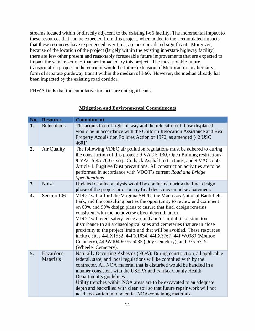
Mitigation and Environmental Commitments No. Resource Commitment 1. Relocations The acquisition of right-of-way and the relocation of those displaced
would be in accordance with the Uniform Relocation Assistance and Real Property Acquisition Policies Action of 1970, as amended (42 USC 4601).
2. Air Quality The following VDEQ air pollution regulations must be adhered to during the construction of this project: 9 VAC 5-130, Open Burning restrictions; 9-VAC 5-45-760 et seq., Cutback Asphalt restrictions; and 9 VAC 5-50, Article 1, Fugitive Dust precautions. All construction activities are to be performed in accordance with VDOT’s current Road and Bridge Specifications.
3. Noise Updated detailed analysis would be conducted during the final design phase of the project prior to any final decisions on noise abatement.
4. Section 106 VDOT will afford the Virginia SHPO, the Manassas National Battlefield Park, and the consulting parties the opportunity to review and comment on 60% and 90% design plans to ensure that final design remains consistent with the no adverse effect determination. VDOT will erect safety fence around and/or prohibit construction disturbance to all archaeological sites and cemeteries that are in close proximity to the project limits and that will be avoided. These resources include sites 44FX1552, 44FX1834, 44FX3767, 44PW0080 (Monroe Cemetery), 44PW1040/076-5035 (Ody Cemetery), and 076-5719 (Wheeler Cemetery).
5. Hazardous Materials
Naturally Occurring Asbestos (NOA): During construction, all applicable federal, state, and local regulations will be complied with by the contractor. All NOA material that is disturbed would be handled in a manner consistent with the USEPA and Fairfax County Health Department’s guidelines. Utility trenches within NOA areas are to be excavated to an adequate depth and backfilled with clean soil so that future repair work will not need excavation into potential NOA-containing materials.
22
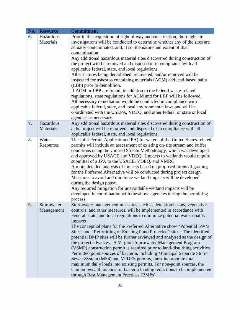
No. Resource Commitment 6. Hazardous
Materials Prior to the acquisition of right of way and construction, thorough site investigations will be conducted to determine whether any of the sites are actually contaminated, and, if so, the nature and extent of that contamination. Any additional hazardous material sites discovered during construction of the project will be removed and disposed of in compliance with all applicable federal, state, and local regulations. All structures being demolished, renovated, and/or removed will be inspected for asbestos containing materials (ACM) and lead-based paint (LBP) prior to demolition. If ACM or LBP are found, in addition to the federal waste-related regulations, state regulations for ACM and for LBP will be followed. All necessary remediation would be conducted in compliance with applicable federal, state, and local environmental laws and will be coordinated with the USEPA, VDEQ, and other federal or state or local agencies as necessary.
7. Hazardous Materials
Any additional hazardous material sites discovered during construction of a the project will be removed and disposed of in compliance with all applicable federal, state, and local regulations.
8. Water Resources
The Joint Permit Application (JPA) for waters of the United States-related permits will include an assessment of existing on-site stream and buffer conditions using the Unified Stream Methodology, which was developed and approved by USACE and VDEQ. Impacts to wetlands would require submittal of a JPA to the USACE, VDEQ, and VMRC. A more detailed analysis of impacts based on proposed limits of grading for the Preferred Alternative will be conducted during project design. Measures to avoid and minimize wetland impacts will be developed during the design phase. Any required mitigation for unavoidable wetland impacts will be developed in coordination with the above agencies during the permitting process.
9. Stormwater Management
Stormwater management measures, such as detention basins, vegetative controls, and other measures, will be implemented in accordance with Federal, state, and local regulations to minimize potential water quality impacts. The conceptual plans for the Preferred Alternative show “Potential SWM Sites” and “Retrofitting of Existing Pond Projected” sites. The identified potential BMP sites will be further reviewed and analyzed as the design of the project advances. A Virginia Stormwater Management Program (VSMP) construction permit is required prior to land-disturbing activities. Permitted point sources of bacteria, including Municipal Separate Storm Sewer System (MS4) and VPDES permits, must incorporate total maximum daily loads into existing permits. For non-point sources, the Commonwealth intends for bacteria loading reductions to be implemented through Best Management Practices (BMPs).
23
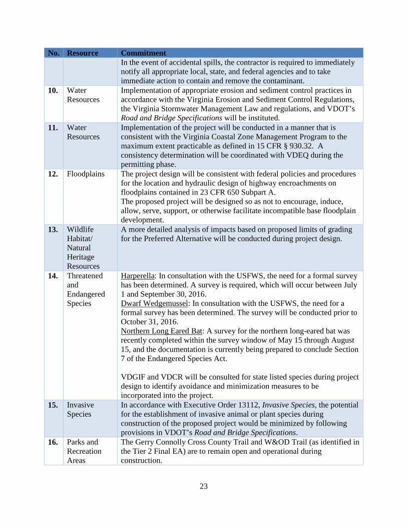
No. Resource Commitment In the event of accidental spills, the contractor is required to immediately notify all appropriate local, state, and federal agencies and to take immediate action to contain and remove the contaminant.
10. Water Resources
Implementation of appropriate erosion and sediment control practices in accordance with the Virginia Erosion and Sediment Control Regulations, the Virginia Stormwater Management Law and regulations, and VDOT’s Road and Bridge Specifications will be instituted.
11. Water Resources
Implementation of the project will be conducted in a manner that is consistent with the Virginia Coastal Zone Management Program to the maximum extent practicable as defined in 15 CFR § 930.32. A consistency determination will be coordinated with VDEQ during the permitting phase.
12. Floodplains The project design will be consistent with federal policies and procedures for the location and hydraulic design of highway encroachments on floodplains contained in 23 CFR 650 Subpart A. The proposed project will be designed so as not to encourage, induce, allow, serve, support, or otherwise facilitate incompatible base floodplain development.
13. Wildlife Habitat/ Natural Heritage Resources
A more detailed analysis of impacts based on proposed limits of grading for the Preferred Alternative will be conducted during project design.
14. Threatened and Endangered Species
Harperella: In consultation with the USFWS, the need for a formal survey has been determined. A survey is required, which will occur between July 1 and September 30, 2016. Dwarf Wedgemussel: In consultation with the USFWS, the need for a formal survey has been determined. The survey will be conducted prior to October 31, 2016. Northern Long Eared Bat: A survey for the northern long-eared bat was recently completed within the survey window of May 15 through August 15, and the documentation is currently being prepared to conclude Section 7 of the Endangered Species Act. VDGIF and VDCR will be consulted for state listed species during project design to identify avoidance and minimization measures to be incorporated into the project.
15. Invasive Species
In accordance with Executive Order 13112, Invasive Species, the potential for the establishment of invasive animal or plant species during construction of the proposed project would be minimized by following provisions in VDOT’s Road and Bridge Specifications.
16. Parks and Recreation Areas
The Gerry Connolly Cross County Trail and W&OD Trail (as identified in the Tier 2 Final EA) are to remain open and operational during construction.
24
Council on Environmental Quality’s Regulations The Council on Environmental Quality’s regulations implementing the National Environmental Policy Act require consideration of a project’s context and intensity in determining whether the project would have a significant impact (40 C.F.R. 1508.27). Context The regulations state, “Context means that the significance of an action must be analyzed in several contexts such as society as a whole (human, national), the affected region, the affected interests, and the locality. Significance varies with the setting of the proposed action. For instance, in the case of a site-specific action, significance would usually depend upon the effects in the locale rather than in the world as a whole. Both short- and long-term effects are relevant.” Since the construction of the project is a site-specific action, significance depends upon the effects on the project area. A description of the context of the I-66 corridor can be found in Section 4 (Affected Environment and Environmental Consequences) of the Tier 2 Final EA. Intensity The regulations identify factors that should be considered in determining whether the intensity of a project’s impacts is such that they result in a significant impact on the environment (40 C.F.R. 1508.27(b)(1-10)). FHWA has considered these factors as described below.
1. Impacts that may be both beneficial and adverse. Construction of the project would have beneficial effects, including improved transportation mobility and travel choices, safety, and system linkage in the region. In addition, the project would support greater use of transit to effectively move more people instead of just more vehicles. Pedestrian and bicycle features will enhance opportunities for nonmotorized travel within and across the I-66 corridor. Mitigation measures such as noise barriers would be provided for communities that currently are not protected from existing noise levels along the corridor. Stormwater management features would be provided within some sections of I-66 that were constructed at a time when less stringent stormwater controls were required.
2. The degree to which the project affects public health or safety.
Public Health
Air Quality. It is not anticipated that the project would adversely affect public health with respect to air quality. The national ambient air quality standards were established by USEPA with public health in mind. The air quality analysis demonstrated that there would be no exceedances of the NAAQS that apply to the project area and, therefore, the project would not adversely affect public health as it relates to particulate matter, ozone, and carbon monoxide. A detailed quantitative assessment of the potential impacts for mobile source air toxics (MSAT) showed that there would be no long-term adverse impacts associated with the Build Alternatives and that future MSAT emissions across the entire study corridor would be significantly below today’s levels, even after accounting for projected growth in vehicle miles of travel. MWCOG completed an air quality conformity analysis of the 2015 CLRP Amendment in October 2015, which
25
includes the I-66 project. The analysis demonstrated that mobile source emissions for each analysis year of the constrained long range plan adhere to all carbon monoxide, ozone season volatile organic compound and nitrogen oxide, and fine particle (PM2.5) pollutants (direct PM2.5 and precursor nitrogen oxide) emissions budgets established by the Metropolitan Washington Air Quality Committee, and found adequate or approved by USEPA. These results provide a basis for a determination of conformity of the 2015 CLRP Amendment and FY2015-2020 Transportation Improvement Program.
Drinking Water. It is not anticipated that the project would adversely affect public health with respect to drinking water quality. Much of the project area, from approximately the US 50 interchange to the western limits of the project, drains into the Occoquan Reservoir. The Occoquan Reservoir is a 2,100-acre water supply impoundment managed by the Fairfax County Water Authority that provides drinking water to residents of Fairfax County and the City of Alexandria. Potential short-term and long-term water quality impacts from release of sediments and other highway-related pollutants into surface waters within the project vicinity will be minimized with implementation of appropriate erosion, sediment, and pollutant control practices during project construction and through incorporation of permanent stormwater management best management practices in project design. The Occoquan Reservoir is more than five miles downstream from I-66. To reach the water supply intake, water entering the Reservoir must travel another 10 miles. Water drawn from the Reservoir is treated in a state of the art water treatment plant before being dispersed for public consumption. Processes in the treatment train include flocculation, sedimentation, ozonation, filtration, and chlorination. Given the stormwater management measures to be implemented at the runoff source, the distance traveled by the runoff before entering the Reservoir and the water intake, and the treatment completed prior to distribution for public consumption, no adverse drinking water impacts are anticipated as a result of the construction of the project.
Children’s Health. No environmental health risks have been identified that may disproportionately affect children. The most likely health and safety risks would be associated with the project’s air quality and noise impacts. Comprehensive analyses of air quality and noise impacts have been conducted for the project. The air quality analysis showed that the project would not cause any violations of national ambient air quality standards established by USEPA to protect human health and welfare, including children. The noise analysis showed that noise impacts would occur throughout the corridor, including at four of the school sites (Tyler Elementary, PACE West, Providence Elementary, and Stenwood Elementary). At each of the four schools, noise barriers have preliminarily been identified as feasible and reasonable for abating noise. USEPA provided comments on the Tier 2 Draft EA pursuant to NEPA and Section 309 of the Clean Air Act. USEPA also provided comments on the Tier 2 Revised EA that was distributed for agency and public review. Under Section 309, if the USEPA determines that the action is unsatisfactory from the standpoint of public health or welfare or environmental quality, USEPA refers the matter to the Council on Environmental Quality. USEPA did not refer this project to the Council on Environmental Quality.
26
Safety The construction of the project is not anticipated to adversely affect safety. On the contrary, I-66 would be an inherently safer roadway than the existing roadway where crash rates at some locations exceed both the statewide and I-66 corridor average. Pedestrian and bicycle travel on I-66 are prohibited and all pedestrian and bicycle crossings are on grade-separated structures. Furthermore, fencing and noise barriers along the highway provide a physical barrier to pedestrian and bicycle entry onto the highway. In addition, the project includes many pedestrian and bicycle facilities that would enhance the availability and safety of travel by these modes.
FHWA finds that the degree to which the project would affect public health or safety does not represent a significant impact.
3. Unique characteristics of the geographical area such as proximity to historic or cultural
resources, park lands, prime farmlands, wetlands, wild and scenic rivers or ecologically critical areas. The Virginia SHPO concurred that the project would have no adverse effect on historic properties along the I-66 corridor. Encroachments on parks along the corridor have been avoided, with the exception of a de minimis impact on Random Hills Park. No wild and scenic rivers will be affected by the project. Neither USEPA nor USFWS indicated that there are any ecologically critical areas in the study area. There is no designated critical habitat in the area for any federally listed threatened or endangered species. There are no prime farmlands along the I-66 corridor. With regard to wetlands, considerable efforts have been made to avoid and minimize impacts, including multiple technical discussions with USACE and documentation regarding the practicability of avoidance alternatives. These efforts will continue during the design phase. All applicable permits will be acquired prior to the start of construction in wetland areas and all appropriate mitigation, to be determined in coordination with the permitting agencies, will be implemented for unavoidable impacts.
FHWA finds that the project would not have significant impacts on historic or cultural resources, park lands, prime farmlands, wetlands, wild and scenic rivers, or ecologically critical areas.
4. The degree to which the effects on the environment are expected to be highly
controversial. The term “controversial” refers to cases where substantial dispute exists as to the size, nature, or effect of the action rather than to the existence of opposition to a use, the effect of which is relatively undisputed. While there has been opposition from some environmental advocacy groups and certain members of the public, there has been no substantial dispute regarding the size, nature, or effect of the project from the environmental resource agencies. In addition, no environmental resource agency has expressed opposition to the construction of the project and USEPA did not find that the project would be unsatisfactory from the standpoint of public health or welfare or environmental quality.
27
FHWA finds that the degree to which the effects on the environment are highly controversial does not require a Tier 2 Environmental Impact Statement.
5. The degree to which the effects on the quality of human environment are highly uncertain
or involve unique or unknown risks. There are no known effects on the quality of the human environment that can be considered highly uncertain or involve unique or unknown risks. Roadways such as I-66 have been constructed around the country as well as within the Commonwealth of Virginia. The potential environmental impact areas from roadways are described in FHWA’s NEPA guidance documents, and the potential impacts from the construction of this project have been identified using standard and accepted methods and approaches for assessing environmental impacts.
FHWA finds that the degree to which the effects on the quality of the human environment are highly uncertain or involve unique or unknown risks does not require the preparation of a Tier 2 Environmental Impact Statement.
6. The degree to which the action may establish a precedent for future actions with
significant effects or represents a decision in principle about a future consideration. This action will not set a precedent for future roadway projects with significant effects or represent a decision in principle about a future project. The impacts associated with the construction of the project are not unique, and any future changes that are proposed to I-66 will be considered on their own merits and in accordance with environmental regulations. In addition, utilizing a Tier 2 EA after a Tier 1 EIS does not establish any precedent since the Council on Environmental Quality’s regulations at 40 CFR 1502.20 already recognize this scenario.
7. Whether the action is related to other actions with individually insignificant but
cumulatively significant impacts. The project has independent utility and does not force additional transportation improvements to be made to the transportation system. The Tier 2 Draft EA, Tier 2 Revised EA, and Tier 2 Final EA contain detailed discussions of cumulative impacts. As stated previously, FHWA finds that the cumulative impacts are not significant.
8. The degree to which the action may adversely affect districts, sites, highways, structures,
or objects listed in or eligible for listing in the National Register of Historic Places or may cause loss of significant scientific, cultural, or historic resources. The construction of the project would have no adverse effect on districts, sites, highway structures, or objects listed in or eligible for listing in the National Register of Historic Places.
9. The degree to which the action may adversely affect an endangered or threatened species
or its habitat that has been determined to be critical under the Endangered Species Act. No critical habitat would be impacted. With regard to endangered or threatened species, there are three federally listed species whose Section 7 ranges intersect with the project area. The three species are the following: the federally endangered Harperella and dwarf wedgemussel, and the federally threatened northern long-eared bat. As discussed in the
28
Tier 2 Final EA, FHWA and VDOT will complete the Section 7 consultation process following completion of surveys for the three species.
Based on FHWA's and VDOT's previous experience consulting with USFWS, even if the project is likely to adversely affect listed species and formal consultation is required, a "jeopardy" biological opinion for any of the three species is highly unlikely. In addition, the formal consultation process requires USFWS to issue a Biological Opinion that contains mandatory reasonable and prudent measures that USFWS considers necessary or appropriate to minimize the impact. All reasonable and prudent measures in a Biological Opinion will be incorporated into the project in order to minimize any potential impacts to threatened and endangered species. Based on the above, the impacts to threatened and endangered species populations would not be significant. Notwithstanding, FHWA will not authorize the use of federal funds for construction until VDOT documents the results of the Section 7 consultation in a NEPA reevaluation for FHWA's consideration.3
10. Whether the action threatens a violation of Federal, State, or local law or requirements imposed for the protection of the environment. The project does not knowingly threaten a violation of any Federal, State, or local law for the protection of the environment. The construction of the project will comply with all applicable Federal, State, or local laws, and all applicable permits will be acquired prior to construction.
FHWA Finding Based on the foregoing information as well as the Tier 2 Draft EA, Tier 2 Revised EA, Tier 2 Final EA, and VDOT’s letter requesting a Tier 2 Finding of No Significant Impact, FHWA finds that the project will not have a significant environmental impact. Therefore, a Tier 2 Environmental Impact Statement is not warranted, and this Tier 2 Finding of No Significant Impact is being issued accordingly. The Tier 2 Finding of No Significant Impact will be reevaluated pursuant to 23 CFR 771.129(c) prior to FHWA granting any major approvals, and the reevaluation will take into account the conditions at that time.
3 In situations where full compliance with other federal environmental laws has not occurred at the time of a Finding of No Significant Impact, the established reevaluation process helps to provide reasonable assurance that all federal requirements will be met prior to construction of a project. Subsequent to a Finding of No Significant Impact, the reevaluation process ensures that all federal requirements will be met prior to construction. In any reevaluation to support a request for authorization of federal funds for construction of the project, VDOT will need to demonstrate that there has been compliance with all applicable federal environmental laws and permitting requirements for such construction, including Section 7 of the Endangered Species Act.