benarat 2003 - caving.ie · introduction dick willis there is a humorous theory of speleo-genesis...
TRANSCRIPT

BENARAT 2003
An Anglo-Malaysian expedition to Gunong Benarat, Gunong Mulu National Park, Sarawak.
G.Benarat, Southern Cliffs © Robbie Shone
Leaders: Tim Allen, Andy Eavis
Editor: Dick Willis
We are greatly indebted to the following for their support and assistance:
The Sarawak State Secretary. The Director of Forests, Sarawak.
The Staff of the National Parks and Wildlife Division, Dept of Forestry, Sarawak.
© Benarat 2003. No part of this report may be reproduced for commercial gain without the express permission of the authors. The report may be used freely for research or education purposes. All photographs are © to the credited photographer. Contact: Dick Willis [email protected]
Page 1

Introduction ................................................................................................................. 3 Statistical summary and future prospects ................................................................... 4 Cobweb and southern Benarat ................................................................................... 7
Cobweb, Southern area........................................................................................... 7 Duelling Banjos...................................................................................................... 11 Hurricane Hole....................................................................................................... 12
North and West Benarat............................................................................................ 14 Relocating Deliverance.......................................................................................... 14 Menagerie Cave .................................................................................................... 14 Terikan River Cave exploration ............................................................................. 16 Elevator Cave........................................................................................................ 17 The River of Sound................................................................................................ 21 Blue Moonlight Bay Cave ...................................................................................... 25 Terikan – Blue Moonlight Bay................................................................................ 26 Terikan West ......................................................................................................... 27 Terikan connection to Menagerie .......................................................................... 27 Daud’s Cave.......................................................................................................... 28 Attempts to connect Deception to Cobweb ........................................................... 29 Help the Aged Hole (aka Rockfall Cave) ............................................................... 30
Northern Api .............................................................................................................. 30 The Search for Blackrock ...................................................................................... 31 Campfire Cave....................................................................................................... 35 Whiterock Cave ..................................................................................................... 36
Expedition Logistics .................................................................................................. 40 Surveying .................................................................................................................. 40
Surveying objectives.............................................................................................. 41 Hardware ............................................................................................................... 41 Software ................................................................................................................ 42 The process........................................................................................................... 43 Instruments............................................................................................................ 44 Surface surveying and GPS .................................................................................. 44 Underground surveying ......................................................................................... 46 Recreating Lost Surveys ....................................................................................... 47 Data correction ...................................................................................................... 48 Compass disaster.................................................................................................. 49 Summary ............................................................................................................... 49
Medical Report .......................................................................................................... 50 Acknowledgements ................................................................................................... 54 UK Members of the expedition.................................................................................. 54 Permissions Etc. ....................................................................................................... 55
© Benarat 2003. No part of this report may be reproduced for commercial gain without the express permission of the authors. The report may be used freely for research or education purposes. All photographs are © to the credited photographer. Contact: Dick Willis [email protected]
Page 2
Introduction Dick Willis
There is a humorous theory of speleo-genesis that circulates amongst cavers from time to time - this holds that caves are formed only when cavers go looking for them, until then the mountain is solid. As cavers progress along a passage, the cave forms ahead of them (or not, depending on the whim of fate!). If this theory holds true then its primary manifestation must be in Mulu. In the limestone mountains of this spectacular National Park lie the world’s greatest caves. Over a period of more than 20 years, British and Malaysian cavers, recently assisted by other nationalities, have explored and mapped hundreds of kilometres of awesome cave passage, rich in formations, biology and geological insights into the earth’s global history. Logic should dictate that so much effort over such an extended period of time should have resulted in the vast majority of the cave passage being located and explored and yet this is clearly not the case. Mulu seems to have a habit of revealing more and more cave, even in areas where the original explorers felt confident that they had exhausted all possibilities. A short climb in Clearwater’s Scumring series, for example, led to the 15km Armistice extensions whilst the terminal rifts in Cobra Cave were found, on re-examination, to connect to the vastness of Cloud Cave. Mulu seems to reward the persistence of its explorers. So it was in 2003 when a group of cavers returned to Gunong Benarat. This trip was itself a follow-up to an expedition in 2000, the first serious visit to Benarat in 16 years. The 2000 trip was a notable success, surveying approximately 13km of new cave passage. The majority of discoveries were in Cobweb Cave, where the total mapped length of the system was extended from 15.1km to 26.7km, making Cobweb the 2nd longest cave in the National Park and the 5th longest in South East Asia. Most satisfactorily, the surveys of the 2000 trip revealed a number of question marks, areas to which the explorers knew they had to return. In 2003 they went back, motivated by those areas of unknown and, in particular, the prospect of locating an underground route to connect the northerly Deliverance Cave (explored by American and Malaysian cavers) to the systems at the southern end of the mountain, Benarat Caverns or Cobweb Cave. In the event that connection eluded them. However, as compensation, Mulu began to reveal a series of caves and passages along the western edge of Benarat which now form the basis of a complex master-cave system. Crucial to these connections was the multi-entrance Elevator Cave, located close to previous discoveries and adjacent to a major path along which generations of cavers have walked, all of them missing the obvious. Or maybe the cave was only formed when they looked in the correct place… © Benarat 2003. No part of this report may be reproduced for commercial gain without the express permission of the authors. The report may be used freely for research or education purposes. All photographs are © to the credited photographer. Contact: Dick Willis [email protected]
Page 3
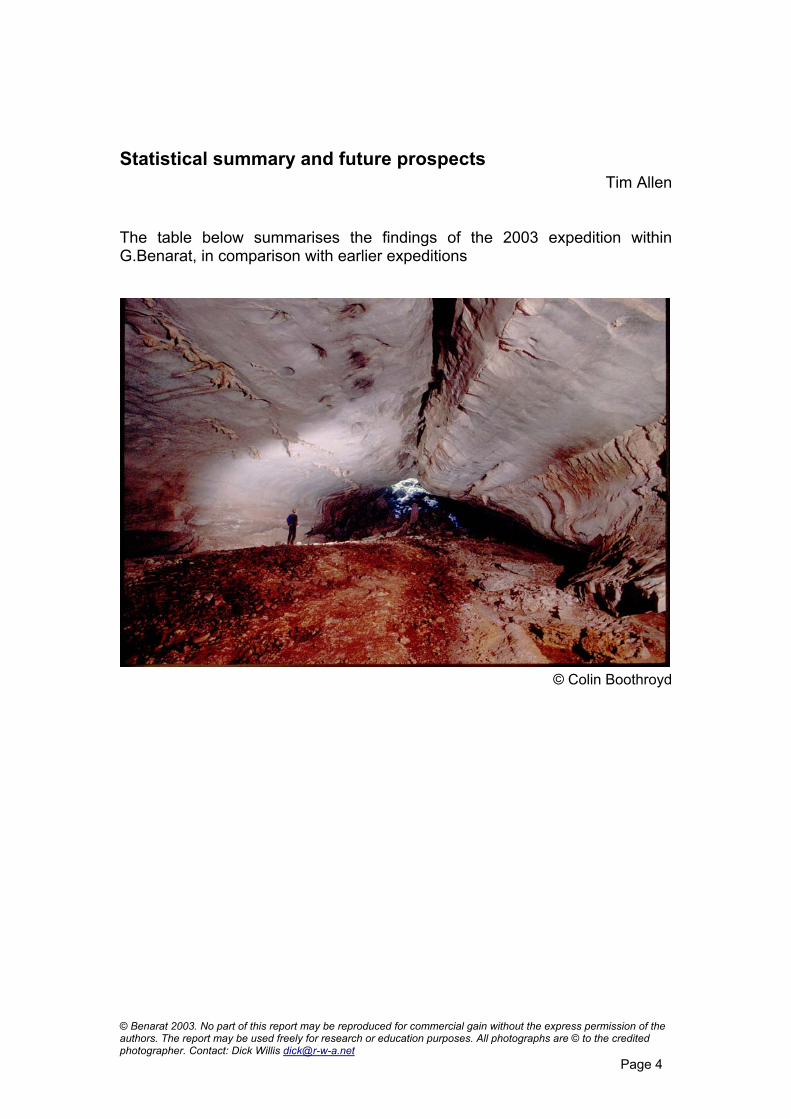
Statistical summary and future prospects Tim Allen
The table below summarises the findings of the 2003 expedition within G.Benarat, in comparison with earlier expeditions
© Colin Boothroyd
© Benarat 2003. No part of this report may be reproduced for commercial gain without the express permission of the authors. The report may be used freely for research or education purposes. All photographs are © to the credited photographer. Contact: Dick Willis [email protected]
Page 4
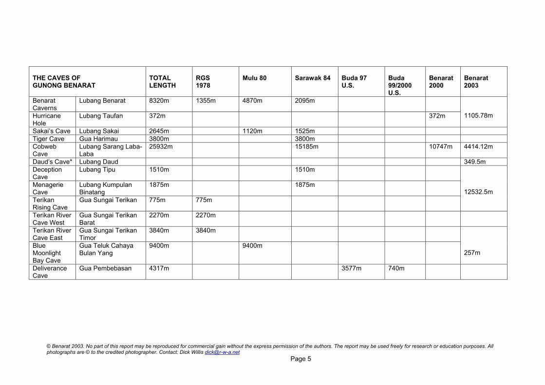
THE CAVES OF GUNONG BENARAT
TOTAL LENGTH
RGS 1978
Mulu 80
Sarawak 84
Buda 97 U.S.
Buda 99/2000 U.S.
Benarat 2000
Benarat 2003
Benarat Caverns
Lubang Benarat 8320m 1355m 4870m 2095m
Hurricane Hole
Lubang Taufan 372m 372m 1105.78m
Sakai’s Cave Lubang Sakai 2645m 1120m 1525m Tiger Cave Gua Harimau 3800m 3800m Cobweb Cave
Lubang Sarang Laba-Laba
25932m 15185m 10747m 4414.12m
Daud’s Cave* Lubang Daud 349.5mDeception Cave
Lubang Tipu 1510m 1510m
Menagerie Cave
Lubang Kumpulan Binatang
1875m 1875m
Terikan Rising Cave
Gua Sungai Terikan 775m 775m
12532.5m
Terikan River Cave West
Gua Sungai Terikan Barat
2270m 2270m
Terikan River Cave East
Gua Sungai Terikan Timor
3840m 3840m
Blue Moonlight Bay Cave
Gua Teluk Cahaya Bulan Yang
9400m 9400m
257m
Deliverance Cave
Gua Pembebasan 4317m 3577m 740m
© Benarat 2003. No part of this report may be reproduced for commercial gain without the express permission of the authors. The report may be used freely for research or education purposes. All photographs are © to the credited photographer. Contact: Dick Willis [email protected]
Page 5

In total, including discoveries in N.Api, the expedition surveyed 22,639.71m of new cave passage. There is obvious potential for connecting the various systems on the west side of the mountain together to create a master-cave system, which would be at least 62,790.89m long. Two short sumps separate Blue Moonlight Bay, Terikan West and the new Terikan System and the gap between Cobweb and the Terikan system is only 230m. However, this gap is the shortest distance between the two caves and represents different elevations. A deep surface valley lies overhead in this area and any connection between the two caves may have to be explored by a much longer route located deeper into the mountain.
Caves of G.Benarat 2003
In addition, there are still a number of possibilities for extending the caves of the Melinau Gorge (Benarat Caverns, Tiger and Sakai’s Caves) northwards to connect with Cobweb Cave. The Melinau Gorge caves total over 16km of passage and while it may not be possible to connect them all into the Cobweb system, there is every prospect of one of them linking up. © Benarat 2003. No part of this report may be reproduced for commercial gain without the express permission of the authors. The report may be used freely for research or education purposes. All photographs are © to the credited photographer. Contact: Dick Willis [email protected]
Page 6
We may therefore contemplate the prospect of an underground network rivalling the Clearwater system of Gunung Api, perhaps not in length but certainly in speleological importance.
Cobweb and southern Benarat
Cobweb, Southern area Pete Hall
One of the first objectives of Benerat 2003 was to continue exploring at the Southerly end of the system heading towards Sakai’s Cave and Tiger Cave. Tim Allen and I had left a strongly draughting lead heading south at the end of the Benerat 2000 at a traverse requiring a rope. So we co-opted Robbie and Wookey to establish a bivouac at the end of Bogeydom (close to M3 on the survey) to push the end. The first trip was on acclimatisation day, so we packed a bag of camping gear and rope each and set off in to see if we could remember the way. However, a surface navigation blunder resulted in a couple of hours of pointless searching about 1km from the entrance. Our underground navigation was good though and we moved slowly and sweatily inwards. Stiff knees were the main problem and by the time we came to Bogeydom Junction and Husky Hall we called a halt and dumped the rucksacks. After a quick look at Husky Hall and the Streamway, we headed out. After an enforced rest day while permit arrangements were finalised, we were back with another rucksack each and frantic packing ensued to try and get eight bags of gear into four loads. Another hour of intense sweating and slip sliding saw us all at the end of Bogeydom where we dumped most of the tackle. Tim and Robbie went to rig Gentlemen’s Agreement - the way on to Streamway Zero – and Wookey and I went for a look down White Fern Passage. After checking out the complex junction close to the camp, Wookey and I looked at both branches of the impressive and very beautiful White Fern passage and arrived at the terminal choke. While Wookey was wondering how to reach a passage 5m up the wall at the top of the boulder pile, I spotted an obscure ascending passage on the right-hand side at the foot of the boulder slope carrying a very strong draught. I returned to camp to get a rope while Wookey started the survey and soon we were down two short hand line climbs and surveying down a descending passage. After a short distance, the draught became less distinct and a bit further on we came to a chamber with a large, deep lake in the bottom of it with catfish swimming around – The Catfish Pool. © Benarat 2003. No part of this report may be reproduced for commercial gain without the express permission of the authors. The report may be used freely for research or education purposes. All photographs are © to the credited photographer. Contact: Dick Willis [email protected]
Page 7

As this was just meant to be a quick jaunt before tea, we just climbed to the top of the chamber to see if there was any way on. And indeed there were four very good ways on, so we called it a day.
Cobweb, The Rubic Tubes © James Alker
Back at camp, Robbie and Tim were jealous after their mundane rigging trip. The following morning, bright and early we packed the remainder of the tackle and set off to Gentlemen’s agreement. A steady plod saw us through Streamway Zero and up the razor sharp climb on the far side into the Rompie Stompies. A handline on the drawbridge was handy and a bit of investigation just beyond cleared up some loose ends and proved that we had made hard work of it last time. After lunch and photos at the outstanding rock sculpture of The Cobra, we fixed more ropes at Big Ben Traverse and Welly Friction Ramp. We had forgotten how awkward the last section of passage had been, especially with tackle but at last we arrived at the end. Tim A. immediately set to work on the traverse that had stopped us last time and, judging by the huffing and puffing, it wasn’t easy. In fact it was still a bit of a swine even when he’d stretched a rope across it. This was followed by a muddy abseil down a ramp down to a T-junction. Left led down more steep ramps and was left for later; right led uphill to a four-way junction. We went straight on, first through a bouldery passage, taking several unexpected turns through holes in the boulders before ending at a boulder choke and a thirty-metre, blind, muddy pitch which the expedition leader ordered the youth to drop. © Benarat 2003. No part of this report may be reproduced for commercial gain without the express permission of the authors. The report may be used freely for research or education purposes. All photographs are © to the credited photographer. Contact: Dick Willis [email protected]
Page 8

Then, whilst Wookey was dropping a similar, but more strongly draughting pitch in the left-hand passage, Tim and I passed a boulder pile in the right-hand passage to survey about 200m of modest walking-sized strike passage with a short crawl leading to a dig. I was about to turn around but our leader was quite insistent – no stone unturned. So through we squeezed into a small chamber beautifully decorated with helictites before it crapped out, the only possible ways on were a pair of airless muddy drainpipes. Back at the junction, Wookey and Robbie had descended a fine 30m shaft in the left-hand branch and I followed. At the bottom a large passage led off but after 50m a short slippery drop was reached not far, as it turns out, from the inlet below Welly Friction Ramp, which ends in a sump. The only other route at the bottom of the pitch apparent at the time was a short ramp down to sumps at water table level. However I think there was another way on among large blocks on the opposite side of the chamber at the foot of the pitch. Meanwhile Tim had been busy climbing down another ramp at water level near our point of entry. Left and downhill at the Ramp Junction a steep climb down led to a squeeze into a rift filled with deep water. A traverse to the far end and a climb up onto ledges reached two steeply ascending bedding planes, both draughting, but both requiring considerable effort and equipment to climb. With all leads examined it was time to turn around especially as it was well into the evening. With nothing to come back to, we also had to de-rig. After a welcome stop at Streamway Zero to wash clothes, tackle and sweaty bodies, we continued to the Power Shower climb back into the higher level. This is a 15m free climb up a wall with plenty of grippy sharp holds. Unfortunately, about half way up, Robbie grabbed a hold that wasn’t firmly attached and came tumbling back down. He was lucky and after bouncing on a ledge part way down landed on a benign, flat slab surrounded by jagged, sharp rocks. Our hearts were in our mouths until we established that the extent of his injuries was just a couple of bruises. It was not until 3.30am that we staggered into camp with bulging rucksacks and collapsed. After a rest day at camp 5 the same four returned to Bogeydom bivi to attack the White Fern branch beyond Catfish Pool. On the way in, retro cavers Tim A. and Wookey had an endless trip down memory lane to the 1980s, reminiscing about obscure music and other nonsense, much to the disdain of the young lads. Our subsequent discoveries were thus named “Memory Lane.” Before we even got to our end point at Catfish pool, we had noticed three passages on the right. The first, at station 13 was short and choked with animal tracks and remained un-surveyed. The second was called “The Learning Curve” after Robbie’s introduction to surveying and consisted of 200m of easy passage heading northeast to a mud choke. The third was a window high up on the right just beyond The Learning Curve and it went. Robbie and I explored this while Wookey and Tim A. went on to the Catfish Pool. © Benarat 2003. No part of this report may be reproduced for commercial gain without the express permission of the authors. The report may be used freely for research or education purposes. All photographs are © to the credited photographer. Contact: Dick Willis [email protected]
Page 9

After crossing a small bowl-shaped chamber, Robbie and I came to a four-way junction at station D4. On the right a passage led off parallel to The Learning Curve ending after a similar distance at a climb down to a choked rift. To the left from D4 a slope led down to a crawl over slabs for 25m with more animal tracks in the dry clay. It emerged at the top of the climb above Catfish Pool, our end point from the previous trip (station memlane2.3). Meanwhile Tim and Wookey had started at this point and surveyed on along large passage past a major junction (at station memlane2.5) reaching a large mud choke after 250m. The draught here was strong and they were trying to dig or squeeze a way through when Robbie and I caught up with them. There was no way on so on the way back Robbie and I ticked off one side passage and Tim and Wookey ticked off the other. Both ended in boulder chokes with signs of the surface. Tim and Wookey got back to the junction at Memlane2.5 first and started surveying the other south-westerly heading strike passage. However, before long it connected back to station D4. Before finishing for the day we felt obliged to make sure there was no way on across the Catfish Pool. So after fixing a short hand line down the steep mud, I took the plunge and swam the 30m across fully expecting there to be no way on. However, on the far side an alcove opened up with a 3m x 3m streamway named “Poptastic” after the same retro conversation, which was still rumbling on from time to time between old boys Tim and Wookey. Wookey, not wanting to get his trousers wet, decided to take them off but unfortunately for me he had no underwear! I prefer to keep my trousers on – some of those catfish have big teeth and are very hungry. The Poptastic Streamway meandered on upstream ankle deep for a couple of hundred meters before the water emerged from sumps where it passed through the beds. Here a small ramp rose in bouldery fashion to end in a breakdown chamber. Another un-surveyed passage carried on for a couple of hundred meters along the strike to the north-east occasionally popping through a thin bed before dividing, the way on unclear. This area is close to the large stream sink passed on the Headhunter’s Trail about 1km before Cobweb cave is reached. With no more leads we returned to the bivi. The following morning, we made a quick tour around Bogeydom No.2 around M3, M4 and M5 on the survey, which appeared to show some open leads. In fact there were none, the apparent large open passage to the left of M6 being just a corner. The only point of interest is that the slope shown to the left of M5 has a climb at the top where a passage could be seen at the top. This is almost certainly a connection with Black Stone Passage.
“Pleased with the day's finds but confused as to how it fitted into the © Benarat 2003. No part of this report may be reproduced for commercial gain without the express permission of the authors. The report may be used freely for research or education purposes. All photographs are © to the credited photographer. Contact: Dick Willis [email protected]
Page 10
Cobweb survey, we headed out and had an awesome walk back in torrential rain to camp 5. It took a good few minutes to get through, after the noise of the rain hit the forest canopy, but soon we were drenched, surrounded by the noise of hammering drops. Another incredible experience in Mulu”! James Alker
Duelling Banjos Tim Fogg
Many times in Mulu, ascending ramps and climbs on the beds has given access to bigger passages above. This was the case for Phoenix in Blackrock, and the Powder Mountain climb in Cobweb. So the similar lead in Duelling Banjos was obviously worth a look, although it was a long haul to reach it. This area had first been looked at in 2000 by Tony White, Pete O’Niell and Tim Fogg and then pushed a little further by Tim and Pam right at the end of that trip. Rigging the various climbs and pitches was a great initiation into Mulu caves, for James and David, and a good reminder for Pete O’Neill and Tim. On the first trip in, they went via the Rubic Tube bivi, into Streamway Two, up past the 16-metre pitch from the Watery Place and on to the big slope down to Streamway Three. Instead of rigging the loose ramp, they rigged a new 10-metre pitch, Brittle Pitch, which drops neatly into the chamber at the back of the big slope, which we also rigged. Taking the round trip back to the Monolith and rigging the short pitch down, meant that the way on right through to Bivi Inn was set up for the next trip. A couple of days later, David, James and I were waking up at Bivi Inn, poised for what Mulu is all about – a climb up into blackness. With James at the pointed end, a series of short but often tight climbs led to a fault chamber 20 m by 20 m with, to our extreme displeasure, no way on. The ‘Indemnity’ extension was so named as James spent much of his time out front saying ‘if this belay fails it’s not my fault’ or ‘if this boulder hits you it’s not my fault’! On the way out from the camp, James tackled a climb up a loose ramp to a roof tube but the looseness got the upper hand. This is a possible lead for the future, as swifts were going in and out of it, but it’s a long way to go for what is not a great prospect. The wet pitch in the Chamber of Horrors also had swift activity and David rigged down 25 m before running out of rope, but it looked reasonable and it echoed so we returned a few days later. However, this squalid rift dropped a further 30 muddy metres to a oval, static sump pool - The Folly was another dead end. A final possibility in the Powder Dome area was a climb back over the top of the Powder Mountain pitch. Unfortunately, a quick scrabble over the massive blocks, jammed in the pitch head, convinced me that the small chamber I could see into was the spot that Ben Lyon and I had reached nineteen years earlier. © Benarat 2003. No part of this report may be reproduced for commercial gain without the express permission of the authors. The report may be used freely for research or education purposes. All photographs are © to the credited photographer. Contact: Dick Willis [email protected]
Page 11
So that is the end of that, for the moment. I guess that Duelling Banjos will be left in peace for many years.
“Tim set up a belay and David descended 12m onto a drip-washed floor with a short step across to good belay on an overhanging block. 12m more to giant chocks, a redirect and then the last of the rope. Landed on an arete with clean walls and sloping rift descending to sloping floor 20m away. Not much draught but a mighty echo. Left rigged. Fast out through wildlife-rich forest in the dark - eyes in forest watching us, stinging centipede, white banded-legged spider, cricket. Home at 11pm.” Dave Scott
Hurricane Hole Tim Allen
On the last day of the Benarat 2000 expedition, a dig, through boulders, had entered Hurricane Hole. Exploration continued throughout the final night until the explorers were halted at a pitch. On a climb further back a solitary boot print had been noticed and this lead to much speculation as to whether a connection had been made with Benarat Caverns. Back in the UK scrutiny of the two surveys proved to be very little help as the passage on either side refused to match up. There was only one thing for it – an early return to drop the pitch. During the first week of the Benarat 2003 expedition a team set off to prove or disprove the connection. The pitch was dropped into a steeply sloping chamber and, sure enough, half way down was the entry of the main Homeward Bound passage of Benarat Caverns. Less than 100m separated the two survey points. The mystery of footprint remains, however, as no alternative route could be found to avoid the pitch. One must assume that at least one of the original explorers did indeed find a bypass, perhaps up through the boulders that form the floor of the entry passage. One thing was for sure - exploration would not stop here as all the explorers had noticed a classic Mulu passage above and to the far side of the recently dropped pitch. Was it just a high level route over Homeward Bound or would it open up a whole new sector to the east. Hurricane Hole is not the most pleasant cave to explore. The flat out, painful entrance passages rekindle memories of caving at home – but with a lot less protective clothing! Further in, the passages take on more familiar Mulu proportions but even so progress is slow. A pitch, huge boulder piles, and a dangerous climb all have to be overcome in the relatively short distance to the connection. Pete O’Neill and Tim Allen took on the challenge of the bolt climb. At first it looked as if the climb would be easy. A simple bolt route up would reach a ledge, which hopefully could be traversed directly into the beckoning passage. The 38m climb up was straightforward although higher than expected. However, once at the top it was obvious that the ledge was non-existent. A curve in the roof and a stepped wall had fooled us from our viewpoint below. The reality was that a very steep wall had to be traversed. It took two trips © Benarat 2003. No part of this report may be reproduced for commercial gain without the express permission of the authors. The report may be used freely for research or education purposes. All photographs are © to the credited photographer. Contact: Dick Willis [email protected]
Page 12

and a considerable quantity of rope to climb the 52m of broken ground to enter the passage. Wookey and Robbie Shone assisted in the exploration and survey from here on. Initially the passage promised much with a healthy strike profile and a river- cobbled floor. Within a 150m, the roof suddenly dipped to within flat out crawling height of the sediment floor. To the left a steep ramp descended in the direction of Homeward Bound and was not explored. To the right a ramp led up a number of technical climbs (the Magical Elevator), up clean calcite to enter a horizontal passage 100m vertically above. Within a short distance this led to a window into the mother of all voids. The nearest wall was measured at 60m away and rocks thrown outwards free fell for 4.2 seconds before hitting the floor. Above, the aven soared out of sight. The void was never descended. Back at the main route various types of crawling continued for some distance. A large boulder run in was passed on the right, which we presumed was associated with the bottom of the huge void. Beyond the run in, classic Mulu strike passage was entered once again. Unfortunately we had no photographic equipment to capture the beauty especially when we encountered a splendid 4m long stalactite hanging in complete isolation. Shortly beyond this the floor ended abruptly over a lower passage. As suspected the survey showed a connection with the Homeward Bound passage without having to descend the pitch. In total 1106m were added to the overall length of Benarat Caverns on this trip, which now nears 10km in length.
“Passage just started to look good when it popped out as a window into the mother of all voids with a stomping great echo. The disto put the far wall at 60m away and stones dropped free for 4.2 seconds before hitting a ledge and rattling down further”. Pete O’Neill “A 4m long stal hanging from the ceiling was the crowning glory: Robbie cursed at having no photo gear whilst declaring the passage to be the best he'd ever explored. It was superb, classic Mulu passage”. Pete O’Neil
© Benarat 2003. No part of this report may be reproduced for commercial gain without the express permission of the authors. The report may be used freely for research or education purposes. All photographs are © to the credited photographer. Contact: Dick Willis [email protected]
Page 13

North and West Benarat
Relocating Deliverance Andy Eavis
On Sunday 26th January, Andy set off from Terikan Camp with Mike and Syria to attempt to relocate the entrance to Deliverance Cave, a strategically well-positioned cave discovered in ‘97 by an American team that had been working in Buda. The group followed good tracks into the Medalam Gorge, keeping at the base of the cliff and following around to the east. Unfortunately they couldn’t get a GPS signal and so decided to climb up the hillside on the north end of Benarat. They still could not get a reliable GPS but found lots of American tape track markers and a number of boulder caves. One was very loose with a very big draft but this was probably a detached block and wind from the surface! They also found what Syria said was a Malaysian bear’s nest! They decided, after this, to try and get back to Terikan in daylight and have another look tomorrow. The next day they set off from Terikan early and arrived at the end of the main track, in the Medalam for 11. This time they went further along the base of the valley until a very well marked American track was found. They followed this up the hillside. All signs of the track on the hillside had gone except for an occasional marker tape. Eventually a cliff line was reached with what looked like a blocked entrance. This was followed up to the left to an entrance full of stalagmite. In between the stalagmite was a very small hole with a very big draft - the elusive entrance to Deliverance Cave. A number of photographs were taken in the entrance chambers of this very impressive cave and a GPS reading was taken close to the entrance. The brisk walk directly back to Terikan took two and three quarter hours.
Menagerie Cave Andy Eavis
On Saturday, February 5th, Colin Boothroyd, Robert Gani and Andy Eavis left Camp 5 after an early lunch having, delayed their start to say goodbye to Pete O’Neil and Wookey, who had left Camp 5 on their start of the journey back to the UK. They were intending to look on the surface near Menagerie Cave. However the first problem was to find Menagerie Cave! Colin had been there the day before but was unable to find the entrance again. Once the position had been located, they went up the hillside in a valley, Colin and Robert following the south side of the valley while Andy went on the north side. On the south side they soon found a cave through a spur of limestone which is probably a detached block. On the north of the valley, Andy initially found an old entrance which, although completely blocked by stalagmite, did confirm that there were caves in the vicinity. © Benarat 2003. No part of this report may be reproduced for commercial gain without the express permission of the authors. The report may be used freely for research or education purposes. All photographs are © to the credited photographer. Contact: Dick Willis [email protected]
Page 14
Colin came on the radio saying he could see an entrance in the north cliff somewhere above Andy’s head. A traverse along the cliff face, greatly helped by unbelievably tenacious trees, led to a large entrance and a quick foray suggested it would go places. On returning to the surface, Andy radioed the other two to join him and, in the process, they disturbed a large eagle perched on a tree above what was immediately named, “Eagle Entrance”. The three explored inwards. After a hundred metres of pretty passage with old gour pools on the floor, a fairly active boulder choke was reached. A lot of squeezing through boulders in a reasonable draft led to nothing. The trio returned and noticed a fiercely drafting hole in the floor. Andy climbed down the first pitch and came to the head of a serious-looking overhang with a big drop. When he got back to the others in the big passage, Robert decided to take a look for himself. After he had been gone some time, the others followed him and discovered he had free-climbed down an alternative pitch in a completely separate side passage. They joined him and found a reasonable chamber leading on and looking very promising. After 80 metres of passage/chamber surveying, they came to an even bigger chamber. Straight across led to a small-drafting, obvious passage in a steeply sloping rift. After 40 metres of fairly interesting, slimy traversing, they dropped to the bottom into phreatic tubes. These popped out under the wall of another substantial passage that went left and right and which Colin thought was Menagerie Cave. One would have thought he might have recognised it since he discovered it in 1984, rediscovered it earlier on this trip and to prove he had rediscovered it, resurveyed it. However, he was not sure and so it was decided to survey again! After 350 metres, Colin decided it was definitely Menagerie and they were nearly at the surface at plain level. Unfortunately, however, they had to return to Eagle Entrance to retrieve Robert’s bag! On the way back, they did various bits of surveying to tie up some loose ends. At the top of the rift in the chamber, guarding the second passage on the left was a substantial cave racer snake. This didn’t seem particularly perturbed by their presence and allowed itself to be photographed from every angle, including very close! Later, some large hatched snake eggs were found in the vicinity. When they got out on the surface at 7.30, Colin’s compass reading ability had unfortunately left him and after a period of forest circles, they eventually found a way down to the plain and back to Camp Five for 11.45 pm. Who would have believed you could spend so long lost, so close to a major Mulu track on a hillside! On Monday the 10th, Colin, Andy and James went back to Eagle Cave to continue the exploration. They went in through Menagerie and up to the chamber in Eagle, now called “Tentacle Chamber” since there were a number of passages going off. The first lead on the left, which was drafting very well, soon led to a huge passage. Colin - this time correctly and accurately - recognised it as Deception Cave, which he had discovered in 1984. © Benarat 2003. No part of this report may be reproduced for commercial gain without the express permission of the authors. The report may be used freely for research or education purposes. All photographs are © to the credited photographer. Contact: Dick Willis [email protected]
Page 15
First, the trio went to the top surface entrance and searched around looking for other entrances. Although the area was very speleological, the only entrance that was found was on the right as you come out of Deception. There was another hole in a cliff face, which would only be reached by aid climbing. They then went into Deception – a beautiful passage, very easy going with two more entrances on the far side. The furthest, a main entrance, and a middle one which was a collapse in the bottom of a surface doline. Between these two entrances, while James and Andy were taking photographs, Colin looked in the roof – goodness knows why! He soon found his way up to “Pooh Chamber”, leading to “Pooh Passage” going upwards at 40 degrees. After a couple of hundred metres, this passage finished up in a boulder and calcite choke. After a lot of attempts at finding ways through this drafting area, particularly by James who seemed utterly determined to get stuck, a retreat to the surface was made. Eagle had been connected to Deception.
Terikan River Cave exploration Colin Boothroyd
Since 1984 exploration of the northern Benarat caves had taken a back seat as exploration of Cobweb Cave and the caves in the Melinau Gorge consumed time and resources. However, as the map of the mountain was filling with details of the caves in the southern end of Gunong Benarat, it was becoming increasingly clear that there had to be extensive caves to be found in the north. Discussions with Tony Waltham, who had originally explored the Terikan River Caves in 1978, encouraged Colin and Pete O’Neill to examine the area around Wilford Hall, within a few hundred metres of the river resurgence. In the hunt for the inlet running onto the Beaufort Series another inlet was found that emerged directly into Wilford Hall. A study of the far wall of the hall revealed a greasy 10-metre climb into a high level passage. Some footprints were noted a short distance into this passage – evidence of other visitors, probably bird nesters, who had found their way into the cave from another direction. The passage, Road to Rebellion, was followed to a junction. The northerly lead led to a large passage that subdivides, one way appearing to lie over Wilford Hall whilst in the other southerly direction the passage was followed to a series of deep cross rifts in the floor that needed rope protection and were never crossed. The principle southerly trending passage at the Road to Rebellion passage picks up a large tunnel that runs north and south. The northerly passage, Palindrome Passage, heads back to the roof of Wilford Hall with a side passage that heads down to the river. The passage to the south is very well decorated with extensive calcite flows and columns before being bathed in daylight at Snail Chamber. Although an exit can be made from Snail Chamber at a high level, it is preferable to remain at a low level to gain the surface at an © Benarat 2003. No part of this report may be reproduced for commercial gain without the express permission of the authors. The report may be used freely for research or education purposes. All photographs are © to the credited photographer. Contact: Dick Willis [email protected]
Page 16

entrance sitting on the hillside only 50 metres away from the Elevator entrance. A short distance prior to emerging at the lower Snail Chamber entrance a passage trending northeast provides an easy alternative to the Snail Chamber route to Road to Rebellion and also reveals the side passage that proves to be the underground connection to Elevator Cave. A small tube in the east wall along Road to Rebellion enlarges after 5 metres in the floor of Sentinel Passage. This beautiful passage abruptly ends at the lip of an imposing pitch dropping into a large chamber, Mustn’t Grumble. The 25-metre drop can be safely rigged through a slot set 10 metres back from the pitch lip, though we didn’t do this and managed to cut through over half way through a rope on the second trip! Mustn’t Grumble is, in fact, a large passage. To the west, below the pitch, the passage unfortunately chokes convincingly, whilst to the east the passage continues, passing through large boulder chokes and side passages, before emerging on the hillside. The two principle side passages were explored for a few hundred metres but in both cases they end at chokes.
“Approx 30m above the river, a series of small draughting upward trending chambers led to large passage. Colin had forgotten to pack a tape, so approx 200m in we called it a halt with the continuing passage heading due south. We exited with large grins on our stupid faces.” P.O'Neill
Elevator Cave Tim Fogg & Dave Scott
The Elevator is an extraordinarily complex series of stacked and inter-linking passages with a multitude of entrances and at least five levels spanning a vertical range of 100 metres plus. The following edited diaries of the entrance area exploration, give some insight to its layout but future visitors will no doubt have to bounce around this maze themselves in order to understand where they are! Following the success of the exploration by Colin B and Pete O’Neill from the southern lead in Wilford’s Chamber, a return was planned to the Terikan area. Tim Fogg, Colin and David set out for the Lubang China shelter on January 29th. From there, taking the Penan trail just up river, past two of their obvious camps, they heard the coarse clatter of hornbills crashing in the canopy above. Stepping up off the trail onto a perilous pinnacle slope they climbed for about 60m. At the point where they would turn left to locate Snail Chamber entrance, they looked high up and to the right and a surprisingly large entrance was evident, which Colin had previously glimpsed. The entrance was big and windy with a large column on the north side. Could this lead into the mountain and south to Cobweb? Amid the jubilation David © Benarat 2003. No part of this report may be reproduced for commercial gain without the express permission of the authors. The report may be used freely for research or education purposes. All photographs are © to the credited photographer. Contact: Dick Willis [email protected]
Page 17

suddenly realised it was his birthday. Birthday and Hornbill were both proposed as names but both had already been used. Surveying the entrance, Tim came across fragments of ancient pottery on a sandy floor, certainly signs of ancient habitation. Sadly signs of recent access by bird-nesters were also evident.
River of Sound – © Andy Eavis
The entrance series is extremely complex, yielding some five different levels. They surveyed in along a lower wide-floored rift with some well-developed phyto-karst. The rift soon gave way to a sloping bedding plane passage. Up-dip an easterly trending lead was left for later as the main passage widened with pillars and roof pendants. Opposite this eastern lead an obvious elliptical black tube, running southwest down the bed, was also put on the back burner. Snake tracks were common and some led off along a 50m section of passage back to a small entrance on the cliff face. Back to another 70m of south trending main passage (now named Many Happy Returns) and a split in the passage. Right led back along a rifted floor to the cliff edge and another elevated entrance with a mud-choked opening just to the south. The route to the left divided again after a survey leg. The passage east had small spectacular solution ‘rosettes’ in the rifted floor. One small floor pool was home to a 5cm white cave crab. A dark, wet and ever steepening pitch was reached, which Colin partly free-climbed until wisdom prevailed. The last section was rigged using natural belays to a rocky arete and the wet rift at the bottom was checked left and right to static pools 34 metres below the pitch head. The passage south led along a rifted floor with a complex of roof tubes. Tim, crawling forward up the ever-tightening tube suddenly popped his head
© Benarat 2003. No part of this report may be reproduced for commercial gain without the express permission of the authors. The report may be used freely for research or education purposes. All photographs are © to the credited photographer. Contact: Dick Willis [email protected]
Page 18
out over a 35m pitch. This was left for another day due to lack of vertical kit! They returned, with hope, to the east-trending lead near the pillars. The initial elliptical passage with a deeply pitted mud floor took a right bend up a cobbled slope and turned again to head directly northeast, after 50m. Tim climbed into a small tube on the right, which led back to a drop into what he thought was Many Happy Returns. This proved later to be the next level or two up in Elevator. After a low section, the fine phreatic 4m tube romped straight on north east for 150 m, often developing a rifted floor, before breaking out down a 5m muddy bank into an east- west passage. East was going, but was unexplored for the moment. West, after 50 m, suddenly and to our surprise arrived exactly where we had planned to be that morning - in Snail Chamber entrance series, at Pete O’Neill and Colin’s station 30. They returned to Terikan camp to the wonderful news of the Blue Moonlight Bay/Terikan connection. On the 30th, Andy and Tim returned to Many Happy Returns to continue the unravelling of Elevator’s many levels. First stop was the pot over which Tim had popped his head the previous day. With two bolts, the floor was reached at minus 35 metres. After a lot of wriggling down tight tubes on the north wall of the shaft, a small chamber, with one nesting swift, proved to be the end. A number of frustrating failures to get digital cameras to synchronise with their flashes, gave the name of ‘Flash Pot’ to this dead-end. Interestingly, subsequent surveying showed the small chamber at the bottom to be close to the end of the Paleo Tubes. Leaving Andy attempting to photograph the crabs, Tim went back to the white, windy tube (White Link) with a pitch, fully expecting to be able to talk down to Andy. Not so: Andy’s whoops were only just discernable, reverberating in the far distance - the big passage below was another Elevator level. Guessing that the elliptical tube heading west from Many Happy Returns could go there, this was the next objective. Wrong level?? This was down to the ‘ground floor’ where it met a T-junction in a low passage with super roof-pendants and the Elevator main entrance to the right. Left was another entrance with a classic showerhead formation. Back at the White Link pitch, six scrunchy metres of pop-corned wall led down to a big trunk passage, the fourth level of the Elevator. Right went back to a ledge overlooking the third level passage and the main entrance, while left led to massiveness and barely distinguishable large holes to the night sky. Back again the next day, Andy, David and Tim Fogg went from the main Elevator entrance via an exposed climb in daylight into the third level canyon, which led 100 metres past another showerhead to two entrances. Looking out of the first, to the west, they had a clear view of a ‘batu’ out on the plain and took bearings on this to try to pin-point their location on the mountain slopes. Back within sight of the main entrance, a 5 metre climb out of the canyon up © Benarat 2003. No part of this report may be reproduced for commercial gain without the express permission of the authors. The report may be used freely for research or education purposes. All photographs are © to the credited photographer. Contact: Dick Willis [email protected]
Page 19

to level four closed the loop on the previous day’s survey, and retracing those legs they got a better picture of the amazing Phytophile area as sun streamed in through skylights. A large aven on the north wall burst up to the bottom of the Phytophile entrance slope and up to higher levels, while a deep gash, dropping to lower levels, had to be crossed. David took the tape up a rising traverse across a wall to reach a platform, covered in extraordinary phyto-karst, some of the spikes where 300-400 millimetres long. From the platform a good view was had into a stonking oval passage going east into the mountain. Also, running south, at a lower level, a big passage with a dry pool in its floor led off. Before going to the stonker, they surveyed up to the Phytophile drip line. This big entrance, 14 metres wide and 20 high, opened on to a cliff and looked southwest out over the canopy. A smaller entrance could be seen lower down on the left (looking out) and yet another was reached up a slope on the right. Climbing down five metres, at the back of the phyto-karst platform, slippery slopes led round to a fine flat-floored canyon running along the south wall of the trunk passage. After 150 metres, a big hole in the floor barred the way and the route on was along a ledge on the north wall, which as it thinned to nothing, ended in a pitch of 12 metres down to a col. The place just wouldn’t finish however - looking back west down the slope another black hole could be seen.
Robbie Shone & phytokarst, Elevator top entrance © Andy Eavis
Going east, down from the col, the passage widened to a junction. Left closed down a bit with infill and after 60 metres the head of a 10 m pitch was reached, but right went on under a whopper of an aven with a passage off © Benarat 2003. No part of this report may be reproduced for commercial gain without the express permission of the authors. The report may be used freely for research or education purposes. All photographs are © to the credited photographer. Contact: Dick Willis [email protected]
Page 20
right to the Paleo Tubes. The canyon in the right (south) wall developed again and we stopped at a deep rift, which cut across it. On the opposite side of the hole was a man-made cairn and a strange rushing noise came and went in the draught. This area had been well visited by nesters, a fact that became disturbingly apparent when, overnight, a rope disappeared, which had been left at the top of the 9 m pitch.
“Beyond, very impressive passage continued in fine style - we followed the bottom surveying but couldn't see to the far side at the top of the cave. Huge hole up to left, then got to a corner, passage trending off southwest, stonking off, very good draught. We left the floor and went upslope over a huge boulder pile. It was misty on top.” Wookey
The River of Sound Wookey
It was our turn up at Terikan camp, where things had got pretty exciting. We had 3 days to see how much cave we could find. They were going to be 3 of the best days’ caving we had ever had. The team consisted of Colin, Andy, me, Robbie, James and Pete O’Neil. Unfortunately, Pete's knee was causing him serious trouble and he had had to turn round after a couple of kilometres as it was clear that he wasn't going to be able to do much. He was even more gutted when he found out what he'd missed. Looking at the surveys the night before, we had noticed that one of the entrances on the Elevator’s many levels was only some 10m from the Headhunters’ trail. As we neared the bridge and the path came right up to the cliff line we kept an eye out for entrances. We spotted a large (~5m wide) entrance some 15-20m up the cliff and determined to take a look at it from the inside to see if it made for easier access to the system. After depositing gear at camp, Andy and I went into the Elevator entrance, finding the way with no real difficulty up through the steep, forested karst approach. Initially we went along one of the levels to check out the cliff entrance but we had forgotten to bring a survey with us and so, while we soon ended up at a pair of entrances with an extraordinary tree root growing some 60m inside, they were not the ones we were looking for. Andy then led the way through the various levels and climbs of this extraordinary, entrance, whilst I endeavoured to learn the salient points for future trips. We were rather surprised to find that the ropes left on both the phytokarst hand-line and the next pitch had gone. It looked pretty certain that nesters had been in during the one day we had been away from Terikan and had stolen our gear. This was more bold than they had ever been before and the risk of being stuck in the cave if they took gear whilst we were inside looked real. Fortunately, the second pitch could be bypassed by an easy 6m climb so we still had a bit of rope for our day's objective. We were soon there - a point in the huge passage where a joint across the floor left a 2m gap. We went up onto the wide shelf on the left in order to rig a © Benarat 2003. No part of this report may be reproduced for commercial gain without the express permission of the authors. The report may be used freely for research or education purposes. All photographs are © to the credited photographer. Contact: Dick Willis [email protected]
Page 21

short pitch back down to the floor beyond the mini-chasm. This was soon done and we started surveying off into wide passage. Almost immediately there was a fork and we took the left-hand branch where the 8m-wide smooth-floored passage swept round the edge of a large space above and to the right. There was an impressive draft blowing out, given the size of the passage. The route had been cairned by previous visitors - presumably the nesters. At the end of this space the various routes came together into one 15m wide, 20m high passage heading directly East, straight into the mountain - just what we were looking for! Soon we came out into a huge boulder-strewn space. Heading up the slope we passed into a misty area near the top of the pile. This was named 'Top of the Evening', after the similar rock-pile in Cobweb, and of course it was rapidly heading for evening-time.
Side passage on the River of Sound, towards the Penthouse © Andy Eavis
Top of the Evening is about 50m x 120m long. A large passage headed south from the bottom corner - very interesting and with a significant draught. From the top we saw a wide gash higher up the eastern wall as well as two 20m wide passages heading off at the North end. Andy followed the left one for 80m or so to find that it went (and contained nesters’ sweet wrappers). We surveyed off along the other one, heading NE. At the foot of the rock-pile the passage continued in fine style - 20m wide, 10 high and soil-floored – and soon lead into a forest of massive stal bosses with a few very small bats flying around - 'Bossphorest'. After 120m of this, we could hear that it opened out again ahead and we decided generously to leave something good for the next party. © Benarat 2003. No part of this report may be reproduced for commercial gain without the express permission of the authors. The report may be used freely for research or education purposes. All photographs are © to the credited photographer. Contact: Dick Willis [email protected]
Page 22

We headed back, well pleased with our afternoon’s work. 500m of massive passage, by far the biggest bit of passage I'd ever found and even Andy was impressed (although he did keep saying that it wasn't as big as Revival in Clearwater). That night there was some negotiation about who would have the opportunity to go where on the following day. Agreement being reached, it ended up with 'team youth' - me, Robbie and James, heading into the Elevator entrance to carry on pushing this world-class lead. The end of Bossphorest belled out, as both walls spread wide, making the passage about 50m across. We noticed a strange sussurating noise ahead but ignored it for the time being. First we tried the route ahead on the left and soon found ourselves looking over a cliff. Peering through the gloom across the canyon it seemed that a shelf continued at this level along the right hand wall but to get there would need some exciting climbing, so we tried the left wall instead. We got to it through more stals in a very wide 3m high bedding and a chossy 3m climb down to the bottom of the passage. 50m along we came to the canyon we had already seen but now were looking up from below and it was easy to cross. The scale of the place was remarkable and simply trying to walk along the passage in the wider sections involved a fair amount of route finding to get round cliffs, holes and boulders. Beyond the canyon the passage settled down to about 20m wide and 25m high with a high shelf on the right side. The bottom consisted of a thick layer of sticky guano into which we sank up to our knees in places. Footprints here clearly showed that one person had been here before us and by the end of the trip we were quite impressed with this caver/nester who had obviously traversed most of the cave on his own. The remarkable sound of the sea continued just ahead of us and it soon became apparent that it was the noise of a large number of bats being disturbed by our advance and wheeling around before flying off ahead of us. The passage became named 'River of Sound' after this phenomenon, which added a feeling of mystery to our excitement. Team youth were very impressed and romped off numerous 30m legs down the passage. At one corner a large stal boss and hole in the floor meant we had to climb round the back of the boss where there was a small pool containing a white cave crab. In an otherwise totally dry passage, the trickle feeding this pool seemed quite permanent. Round the next corner the passage opened out again to 50m wide, so only one wall could clearly be seen at a time. We stopped for a bit of lunch and to congratulate ourselves on our success. A high joint passage headed off on the right and contained a steep guano pile - a quick check showed that it was continuing, although Wookey sank to his waist in the guano on his return. Not quite sure which way to go, we surveyed up-slope towards the far wall, then back down again to another smooth notch passage. Once again the © Benarat 2003. No part of this report may be reproduced for commercial gain without the express permission of the authors. The report may be used freely for research or education purposes. All photographs are © to the credited photographer. Contact: Dick Willis [email protected]
Page 23

walls were too far apart to be visible from each other so we had to pick one (the easiest one) and follow it. There was still a good breeze and our already wide grins widened even further. A couple of survey legs further on almost the whole huge passage was blocked by calcite. Only a small 2m x 3m window remained and the gale through this gap was quite extraordinary - none of us had ever come across anything like it - guaranteed to blow out a carbide lamp. Beyond, the notch continued but now on the left wall, with the right hand one invisible up the slope. After 5 more 30m legs, the passage straightened up and became a deep canyon and we threaded past columns and boulders to find the most impressive section of passage so far - about 20m x30m with a fine pentagonal shape developed along a joint. Robbie was itching to bring a camera here to try and capture the majesty of it. This really was the best bit of cave any of us had ever found, by a hefty margin, and best of all we hadn't needed any rope or SRT gear! Wandering around with nothing but a notebook was a very strange feeling - I kept thinking I'd forgotten something. After 8 x 30m legs in a row, our run came to an end and the way on became less obvious; the roof came down and there were piles of boulders everywhere. Huge bats wheeled about all around us, still making eerie windy noises as they cut the air - and shitting on us as they passed. We started to feel like the humans with targets on their heads, as in the 'birds eye view' FarsideTM cartoons, so this Chamber got the inspired name 'Farside'. We poked in various places trying to work out where the draft came from. There were two chokes going up to the right (East) - James disappeared into the first, Robbie into the second and Wookey tried going down-slope over the huge boulders. The second choke drafted somewhat but neither obviously went. However down and left (West) was going passage. This was much smaller at 7m wide x 3m high and the draft was now going with us but it would normally be a fine find for anyone not spoiled by over half a kilometre of monster passage!, A 3m down-climb led into a complex area with a small passage off left then popping out into larger 8m x 10m passage. Here we saw a .9m long cave racer slither off under a rock. At a corner with a good draft and a bit of nester graffiti, we decided it was time to call it a day and head back, leaving something good for the next team. Back in Farside, we followed the left hand wall over large shitty boulders and through breakdown to larger passage with a ~10m pitch leading off to the North. On the return back, below where we had started, we followed the right wall down more big passage (15m x 20m) with a string of 30m legs which led us back into Top of the Evening - this was the passage Andy had looked down on our first trip. © Benarat 2003. No part of this report may be reproduced for commercial gain without the express permission of the authors. The report may be used freely for research or education purposes. All photographs are © to the credited photographer. Contact: Dick Willis [email protected]
Page 24
What a fine trip - 2 queries ticked off, 8 new ones (all rather smaller). All of us had experienced a real 'Mulu trip' with just about 1km in the book and some absolutely fantastic passage. I've not often spent time having to follow one wall or the other due to not being able to see the other one, or getting confused and heading across the passage instead of along it.
“Andy gracefully bowed out so 'team relative youth' got the chance of some serious Mulu passage. Off from camp reasonably early. Into the cave to the front, where James started with a couple of legs across the passage just to show that it really was 50m wide! Romped along huge passage...” Wookey
Blue Moonlight Bay Cave Tim Fogg
Blue Moonlight Bay had not been visited since its exploration during the Mulu ‘80 expedition. As it was 9.4km long and contained a major section of the Terikan River, it was high on the agenda of the 2003 expedition. Of major interest were the passages heading south towards Cobweb. The gap between the two caves could easily hide many tens of kilometres of passages that once formed a single master-cave system. It took two trips to locate the entrance, high up on the karst. A number of other caves, including Tea Time Hole, were found on the route but it was impossible to tell whether they already been descended back in 1980. Eventually it was Tim Allen and Pete Hall who found their way to Dark Star Chamber and down the pitch to the river passage. The route to this point was much more complicated than shown on the survey with many oxbows and alternative routes. A way was eventually found into Batukah Chamber and up into Strangers’ Gallery to the pitch down to the Casting Vote. This was the turn-around point on this trip, but the duo were inspired after disto measurements showed the Casting Vote to be 15m wide by 42m high, a major passage indeed. They were further pleased to find the trip back to the entrance only took an hour, now that the best route had been located. The duo returned later in the expedition, accompanied by Robbie Shone, and investigated first the most southerly passage off the Casting Vote. This passage draughted well, right up to the end, where there was a calcite choke. Pete found a way past this into a boulder-choked chamber. He wormed his way up this to a steep ascending calcite ramp. Unfortunately, the ramp went vertical near the top and stopped his progress and, although we presumed the draught came from the top, nothing could really be seen. They next investigated the south-eastern end of the Casting Vote. This was very much as shown on the survey, with the major passage dipping down into a complete boulder choke. The undescended pitch near this point was not descended but probably should have been! It is big and by dropping rocks the team estimated the depth to be nearer 40m than the 20m indicated on the survey. © Benarat 2003. No part of this report may be reproduced for commercial gain without the express permission of the authors. The report may be used freely for research or education purposes. All photographs are © to the credited photographer. Contact: Dick Willis [email protected]
Page 25
On the way back to the pitch an oxbow was discovered on the southern side, which connected to the side passage 100m before the pitch is reached. They climbed into a superb section of passage, continuing beyond the pitch, but this ends close to the collapse of Dark Star Chamber and was little different to that shown on the survey. The 1980 explorers had done well and the team was a little disappointed not to have broken through into significant new passage. However, it is hard to believe that with more effort, at the remote leads, Blue Moonlight Bay will not yield up its undoubted secrets in the future.
Terikan – Blue Moonlight Bay Pete Hall
During my first spell at the idyllic Terikan Shelter Andy and I decided to try to find the way between Terikan East Cave and Blue Moonlight Bay Cave. So we strolled up to Nine Inlet, which I had passed on a previous jaunt with Colin and Syria, and set off in, following the survey. We had soon navigated to the point in the Clay Series where the two caves seemed to overlap (survey errors notwithstanding). Here, we were told, we would find a pitch but instead we found a boulder choke. So we got to work crawling around in the boulders trying to find a way through. After an hour or so of nerve-racking and fruitless work we had a break for lunch then started again with renewed vigour. Eventually I heard Andy calling that he had found a way through and he came back to start the survey and show me the route. After 20 minutes of surveying a crawl up through the boulders, we emerged on top of them about 20m from where we had started, almost looking down on our start point! Another leg took us up the slope to where the boulders met the roof but on the right hand side was a small hole under the wall at floor level with the draught issuing from it. There was also the telltale sound and smell of bats. We shifted a couple of boulders out of the way, crawled through and went up a short climb between a block and the wall. From there we could see daylight streaming in from the surface shaft that was marked on the Blue Moonlight Bay survey. There was a large smelly bat colony and the sound of a thundery shower on the surface. The first thing that goes through the mind when two caves are connected is “can we do a through trip?” We had a very sketchy understanding of Blue Moonlight Bay Cave but we did have a laminated survey and plenty of time, so off we went. We should have smelled a rat when the straightforward small passage, which the survey showed to have no floor detail, turned out to be a series of breakdown chambers connected by hard to find and obscure ways through boulder chokes. From there we came to a complex of junctions, all with footprints in the sand and all looking similar. The survey wasn’t much help, so Andy decided we could get through by sheer determination alone and steamed off at high speed, certain that we would find something he © Benarat 2003. No part of this report may be reproduced for commercial gain without the express permission of the authors. The report may be used freely for research or education purposes. All photographs are © to the credited photographer. Contact: Dick Willis [email protected]
Page 26

recognised before long… Half an hour later and sheer determination had not worked! We were more confused than ever and getting into the realms of not being able to find our way back. So we decided to have a more concerted look at the survey. So we sat and studied for half an hour. The result was that we realised that we could not get out without doing an 8-metre climb down and a 10-metre pitch up. We thought we might have found the 8m climb but weren’t sure, so we reluctantly retraced our footsteps. Back in the Clay Series, whilst searching for the connection, I had found a pitch that Colin had told us about. It looked good. It was at the end of a 10m-wide passage and had a decent draught blowing up it and a pool at the bottom. In spite of all the afternoon’s shenanigans, we still had time for a quick look, so we took a rope and dropped the pitch, of 13m, which landed in the pool. A low sumpy-looking passage led off and after lowering over a large mud bank, it developed into a nice streamway. Unfortunately, this was short-lived and a smaller passage with an upstream sump on the right turned out to be the end of the streamway and, shortly afterwards, the passage ended at a steep, 15m high steep climb, down which the draught was blowing. Andy climbed up in a shower of falling boulders and found a passage at the top. However, lack of time and the need for a rope forced us to survey out. Higher priorities elsewhere in the Terikan system prevented a return to this point before the end of the expedition
Terikan West Pete Hall
On another trip to Terikan West on February 10th, Tim A., Robbie and I thoroughly explored the upper rifts and Inlet 7 in an attempt to find a way between Terikan East and West, bypassing the sump. However our search was fruitless. The most promising lead was a draughting boulder-choke at the south-western end of the upper rifts but no way through could be found, in spite of it being below the Go On series in Terikan River Cave.
Terikan connection to Menagerie James Alker
After the jaw-dropping exploration of the River of Sound, which cut right across the Batu Mentawai spur, we turned our attention to the leads heading east and south off this main passage. One of these leads appeared wide-open but it quickly closed down to a rift. The draft kept pushing Colin on but a lack of kit meant that we had to leave an un-descended pitch. On the return Colin, Robbie and James rigged down a slope on the side of a © Benarat 2003. No part of this report may be reproduced for commercial gain without the express permission of the authors. The report may be used freely for research or education purposes. All photographs are © to the credited photographer. Contact: Dick Willis [email protected]
Page 27
large chamber to where it dropped off. Colin placed a bolt by hand (and was roundly abused for taking so long). He dropped down 6m to a ledge from which a passage led off and, as he disappeared, we rigged the rest of the way down off a flake and spike. A drop of approximately 20m went to the very muddy floor of the chamber. At the re-belay on the main hang we received reciprocal abuse from Colin (who had returned from a dead-end passage) for not noticing daylight at the far end of the chamber! The base of the chamber was a boulder filled mud hole, which must sump in wet weather and a cliff, halfway up the chamber, blocked a possible way on. Various climbs were tried but Colin had wriggled through a cunning route underneath and climbed out above. We surveyed up this chamber slope from the base of the pitch and found footprints beneath the daylight window. Colin now justified his existence! He knew he had been here before but he couldn’t remember where it was! So, on his insistence, we surveyed all the way out of what turned out to be Menagerie Cave, which Colin and others had found and surveyed in 1984. The footprints led through beautiful tubes past a cave racer coiled on a wall ledge, to a junction chamber and walking passage to the entrance. We knew we were only metres from the surface, because we could smell the forest, but Colin still couldn’t remember the way! After a tense half hour and thoughts of having to go all the way back, the exit was found and 5 minutes later we were back on the Head Hunters’ Trail. This connection brought the Terikan system much further south and cemented the belief that connections could be made relatively close to the surface, in order to work south to Cobweb, rather than pushing deep inside the mountain.
Daud’s Cave James Alker
The discovery of Eagle Cave and the connection of Terikan, Menagerie and Deception into one system created a very real possibility of creating a single, huge system. This found Pete Hall and James Alker revisiting the unpromising 500m-long Daud’s cave, which had been found in 1984. Daud’s sits in the gap between the new system and Cobweb but was also next to a surface valley on the mountainside. The left-hand lower entrance was entered and it was decided to repeat the survey in from here to get an accurate location on the now very impressive computer program. We did not revisit the right hand side of this cave. Continuing down a climb, after 150m or so, we reached the main chamber, which is 25m across. All leads were checked and it was eerie to crawl into small passages and find footprints from 19 years before, when Tim Fogg, caving solo, had pushed nearly every lead. A stooping/crawling miniature overflow streamway was followed, disappointingly, to a sand choke, whilst the main passage ended in a big consolidated boulder choke. On the way out, © Benarat 2003. No part of this report may be reproduced for commercial gain without the express permission of the authors. The report may be used freely for research or education purposes. All photographs are © to the credited photographer. Contact: Dick Willis [email protected]
Page 28

Pete noticed that the breeze increased and more checking high up on ledges found another crawling passage, which Pete pushed until it became too tight. After all, this was Mulu, not Yorkshire, but when the data was punched into the computer it was only 150m from the nearest passage in Cobweb!
Attempts to connect Deception to Cobweb James Alker
Parang’s entrance, a dry mud packed tube, had been opened up a few days previously. Using a parang to cut the mud into neat blancmange-like slices had enlarged a small air space, with a wind whistling out. The entrance had been connected to previously surveyed passage in Deception and provided a quick way to the vital leads at the southern end, closest to Cobweb. With Pete Hall and park guide Lawai I went to Parang’s in the last days of the expedition, still on a mission to create a 63km system. The tight upslope entrance crawl led to walking passage and up to a hole in the floor. We worked around this and started surveying in but after 2 legs it got too small and there was no breeze. The only other way on was down the rift, which had, we thought, been previously descended, and as confirmation I found footprints after a 10m pitch. I climbed up through sticky mud to another hole, which required a bolt for descent. Pete was determined not to give up and made his way down and then continued up a horrendous mud slope, which nearly filled the passage to the roof. He located a breeze continuing up the slope, squeezed through and called me up. The passage had enlarged and dropped down a very loose climb to a way on. We started surveying, feeling very guilty for leaving Lawai behind, but consoling ourselves by saying that he had no SRT kit and would not enjoy the mud. The passage kept going through breakdown chambers, always continuing up. At a junction we continued left and while Pete looked at another climb I found a breeze in a wall! We moved a few rocks and a small gap appeared to open out. We squeezed through and found ourselves in a 5m wide passage that continued in both directions. Leftwards led upward and tell tale calcite flows showed we were nearly at the surface: daylight showed through a scary squeeze over snake tracks. I kept thinking I was going to come face to face with a cobra as the afternoon thunder crashed outside. So Thunder cave was named and we guiltily hurried down the steep slopes back to Lawai, a TV-sized block nearly squashing me on the way. The next day we returned and all surveyed down the pitch and into the previous day’s discoveries. Sure enough, Lawai wasn’t impressed with the mud, dodgy climbs or grotty breakdown cave. All other leads were checked and some boulders were even dug out to enter a squeeze - only to make a loop. A stream trickled in and, in the hope of finding a connection to Cobweb, I climbed the aven but time was up and we had to return. The survey showed that we were only 230m short - next time hey! © Benarat 2003. No part of this report may be reproduced for commercial gain without the express permission of the authors. The report may be used freely for research or education purposes. All photographs are © to the credited photographer. Contact: Dick Willis [email protected]
Page 29
“Looked closely at the back of the cave, the sediment was piled up close to the roof but the gap above emitted a howling draught. We decided that the time for digging was again right for Mulu and set to work with the parang. Within minutes we were through to a rise in the roof. Several more short digs saw us in walking passage.” Tim Allen “A connection to Deception or Cobweb or even both, was the aim! ... Pete climbed up on the left and found another delightful crawl in a good draught. This was going towards Deception but got too small. We surveyed out and, when drawn up, it turned out that we were only 40m below the Catapult entrance area of Cobweb”. James Alker
Help the Aged Hole (aka Rockfall Cave) James Alker
The Benerat 2000 report mentions an entrance 50m above the top of a new collapse on the south-west corner of the mountain. After 8 days of caving in Mulu the “youngsters”, Robbie Shone and James Alker, were yet to make a major discovery. So, after a night of stories about bolting escapades, we left Camp 5 armed with bags of bolting paraphernalia and were guided straight to the cliff by Syria and Jenny. Even after 3 years of tropical rain the boulders were still loose but they were dry that morning and so the climbing began. Tim Fogg’s bolts were reached along a dodgy, rising traverse. His hangers and maillons were recovered but his sling had been more than slightly damaged by UV! With Robbie belaying, I started climbing with a drill and a few hard-severe moves on very loose rock led to some holds where a bolt could be placed. I continued up, mixing bolts and moves for about 20m to a ledge where I could belay for Robbie. He then moved up over the final calcite bulge toward the entrance, which was tantalisingly close but he was still unable to see inside. The final move was necky, so we managed to lasso a stalactite and Robbie prussiked up to the 8m wide 4m high entrance. He returned with a smile but once I was up he told me the frustrating news that the passage only went 15m to a calcite choke. However, it was home to a colony of bats. However, the views across the canopy westward were incredible and as far as we could see was a sea of green with the occasional rise of a batu. We descended, pulling the ropes through and stripping the hangers as we went, and made it back to Camp 5 for lunch, now even keener to decide our next objective.
Northern Api Matt Kirby
© Benarat 2003. No part of this report may be reproduced for commercial gain without the express permission of the authors. The report may be used freely for research or education purposes. All photographs are © to the credited photographer. Contact: Dick Willis [email protected]
Page 30
Whilst attempting to relocate the entrance to the Blackrock System, two new discoveries were also made in Northern G.Api. These were Campfire Cave

(272.79m), which is located in an isolated block, and the more significant White Rock Cave, which now has a surveyed length of 3707.72m. Further exploration will almost certainly confirm that White Rock is almost certainly a part of Blackrock Cave and therefore a component of the Clearwater System. However, no connection has currently been established.
The Search for Blackrock Northern Api has tantalised explorers for many years. The southern extremities of the mountain have revealed a labyrinth of passages on many levels, but a large blank area of limestone remains between Blackrock Cave and the Melinau Gorge. It has always been hoped that a continuation of the single minded passages of Benarat’s Tiger Cave would be found in G.Api, on the other side of the Gorge, leading to caverns measureless to man. Unfortunately this has so far proved elusive. Previous work from Camp 5 has been limited to the area around the Gorge and Pinnacles. Although a fair amount of ‘surface-bashing’ has been carried out over the years around Camp 5, the details are fairly sketchy. A number of minor foot caves have been found (some documented by the 2000 Benarat expedition) but generally these show very little potential. During 1984 the team exploring Tiger Cave, in Benarat’s southern cliffs had observed one large feature, named Canopy Cave, in the north end of Api, upstream of Camp 5 and above the canopy and scree line. This feature had been visited during the ‘84 expedition but massive walls of sediment had prevented entry and it had been suggested that this was worth another look. However, in the back of my mind was a conversation with someone who had suggested that it had already been entered. Further enquiries among the guides (Bagley Lang) revealed that Simon Lagang had scaled the sediment cliff using crampons during the 1991 Korean expedition and had found that it was completely full of sediment. Unfortunately the Koreans did not produce a report so this fact had never been documented. As a result, it is still not known whether this feature is a sediment filled cave passage or simply a choked overhang. Previous expeditions had proven a hydrological link between sinks in the Gorge behind Camp 5 and Clearwater, which suggested phreatic development, however this does not prove that high-level fossil passages exist. The discovery of Blackrock Cave in 1988 had demonstrated that strike controlled passages exist further to the south but the area between here and the Gorge presented a tantalising mystery. Blackrock’s Firecracker passage is one of the longest straight-line passages in Mulu. The modern day stream, which flows through it, is a misfit, derived from marginal drainage and surface percolation; it has nothing to do with the original cave development. However, this passage is at base level and cannot be described as a high level fossil © Benarat 2003. No part of this report may be reproduced for commercial gain without the express permission of the authors. The report may be used freely for research or education purposes. All photographs are © to the credited photographer. Contact: Dick Willis [email protected]
Page 31

route. Indeed, if it was to extend as far as the Gorge it would be fairly close to the present day river level. Unfortunately Firecracker ends in a massive calcited collapse. At this point the surface features change as a large cliff line, which runs northeast/southwest, intersects the bulk of the mountain. To the north of this, the slopes of the mountain are far shallower. During 1980, Jon Buchan, Dick Willis and Mike Meredith spent a number of days working up to a point southwest from the pinnacles, along the top of this cliff line, to investigate a large collapse feature, which was spotted from the air. This fools-errand revealed a depression with no sign of cave development. However, with the discovery of Blackrock Cave, it appeared that the feature was fairly close to the northern end of Firecracker. At this point the passage rises up to a massive calcited boulder collapse that suggests close proximity to the surface. However, it is not known whether the feature is connected with Firecracker or whether their locations are purely coincidental. Richard Chambers and I arrived at the mid point of the expedition. We were ‘Api veterans’ and this was the first time we had been based at Camp 5. We proposed to investigate the area between the Melinau Gorge and Blackrock Cave; an aim which led to a monstrous hiking challenge and Mulu foot… Initial intentions were to head southwards from Camp 5, following the base of the cliffs, eventually to reach the Racer entrance of Blackrock, a distance of 4km. Clearly this would take a few days and past experience had shown that it would be an ‘interesting’ challenge. Talk of a large entrance just off the pinnacles track led to a detour up the slopes on day one. Traversing to the south revealed that large cliffs, which make horizontal progress impossible, intersect the side of the mountain. Following a series of difficult scrambles down tree roots it was decided to take the easier route at base level but the fabled ‘Large Entrance’ was unfortunately not to be found. After a couple of hours a minor cave/overhang was discovered containing a small colony of bats. Another entrance was found just round the corner. The nature of the rock in this area was strange, appearing to be a conglomerate of broken limestone. Neither cave merited a survey. Progress led into a valley with the slopes to the east at a fairly easy gradient but the going became more difficult as the route led onto karst terrain. After a battle around and through some large tree fall, on steep ground, a col was reached. From here the slopes eastwards appeared to form a gentle rise up to the bulk of the mountain. The large white cliffs above the northern end of Blackrock could be seen on a bearing of 121°. Owing to the difficult nature of the route in, and with a certain amount of curiosity, it was decided not the retrace steps back to Camp 5 but to head due west in the hope of finding the Camp 5 track which we did at the 6.8km point From the col the ground rose up onto alluvial fan deposits and generally the going was fairly easy. Another fairly insignificant cave entrance was found. Once again this was in the conglomerate material. © Benarat 2003. No part of this report may be reproduced for commercial gain without the express permission of the authors. The report may be used freely for research or education purposes. All photographs are © to the credited photographer. Contact: Dick Willis [email protected]
Page 32

As the transition from the alluvial plain to the foot-slopes had been found to be fairly indistinct it was decided to try a direct approach to the mountain side from the Camp 5 track, with the hope of finding Racer entrance. This was a direct distance of 1km. Prior to the arrival of the expedition in Mulu, exceptional rainfall had caused the Melinau to change course. This meant that the Camp 5 track now involved two river crossings, as the central section had become a four-kilometre long island. It later transpired that this new channel had been the course of the river at the time the aerial photographs had been taken, during 1960. This proved very useful in subsequent identification of features. It appears that the Melinau regularly changes course between these two channels. It was decided to follow the track south to where the river had changed course, then cut due east. This proved disastrous as the ground is low lying and has been subject to frequent flooding, leaving a tangle of impenetrable secondary forest. The attempt was finally abandoned when we hacked ourselves into dense rattan which transpired to be the home of millions of stinging fire ants. The nature of this type of terrain is almost impossible to describe - there is never an opportunity to see ahead in order to determine a best route, so it is simply potluck whether a clearing is found. Thwarted by ‘rattan alley’ we headed back to the river after making only 50m progress in more than an hour! From the river crossing the cliffs looked tantalisingly close and so a second attempt was made from 100m downstream. Once again dense secondary growth prevented progress. It was clear that finding a way to the mountainside from here was a total waste of time. In order to make the best of the day, a drastic course of action was taken - to head for Kuala Lutut and to try to re-establish the old track to Leopard Cave. We headed off in the hope of finding some evidence of the old route. Alas this had long since disappeared and so new route finding was required. This proved successful, however Leopard Cave was much further south than we wanted to be, so this route in to the target area would require a considerable round trip. The nature of the ground between the river and Leopard Cave is varied. The track had been established by Penan before the 1988 expedition and generally followed easy ground. However, Europeans don’t have the same knowledge. On the way in we discovered that a line of karst intersects the route. A tortuous route was found through this, which lead onto higher ground before dropping back to swampy terrain north of Leopard Cave. At no time had any evidence of the original track been found nor any feature been recognised. As light was beginning to fade it was decided to take a bearing from Leopard Cave back to the river and try to find evidence of the old track from that direction. Once again there was no trace and indeed we crossed our own inward track without noticing it and managed to reach the river north of Kuala Lutut without even finding the band of limestone! © Benarat 2003. No part of this report may be reproduced for commercial gain without the express permission of the authors. The report may be used freely for research or education purposes. All photographs are © to the credited photographer. Contact: Dick Willis [email protected]
Page 33
As the route in via Leopard Cave was now open, it was decided to return carrying bivvy gear and with the intention of locating Racer entrance and pushing known leads. What a silly idea! We returned the following day with Olly. On this occasion we managed to get completely tangled up in the karst band. In fact we had hit it slightly further to the south, where it forms large pinnacles and canyons, which sap the strength and drain all remaining fluid from the body. Much thrashing about ended in a complete retreat and change of direction further to the north. Fortunately, this led onto the previous day’s track through the barrier. After fire ants had attacked Olly, the group reached Leopard Cave. Northwards the trail was fairly straightforward as it generally follows the side of the mountain. Again there was no sign of the 1988 track, so it was necessary to hack a new route through spiny palms and rattan. After a particularly dense section the Imperial Cave streamway was found. Imperial Cave takes marginal drainage from both north and south via two entrances. The two streams join within the cave before entering a sump and this water eventually joins the Leopard Cave streamway. During 1988, the Penan had hacked a route up and over the Imperial Cave batu but later in the expedition this was abandoned for a more level but longer route around. On this occasion it was decided to go over the top, as this would be more direct. Although successful, this only added to the dehydration. Three previous expeditions had slogged over and around this batu because ‘someone’ said there was a sump in Imperial Cave, which prevented an easy route through; in all this time no one thought to check this out! However, the Caves of Mulu ’80 report states “A notable feature of this cave is that the journey between the two entrances is much easier underground than through the forest” Oh bother! From the far side of the batu, Blackrock’s Centipede entrance is only 200m away. This is where theory and practice began to diverge. What appears as 200m on the survey can seem endless when tired, dehydrated and surrounded by a dense tangle of secondary forest. More hacking led to a point where a clear slope leads up to small cliffs. Both Richard and I remembered this as ‘the climb up to Blackrock’ - how wrong you can be: it’s amazing how the memory fades over 15 years! Yes, there was a ‘familiar’ slope, yes there was a small cliff, yes there was a cave, but no, it wasn’t Blackrock and no we hadn’t found it 15 years before. Light was beginning to fade, as it does very quickly on this side of the mountain. A scout around the area didn’t reveal anything that remotely resembled the Blackrock entrance so we decided to bivvy the night in the new entrance. Narrow squeezes led into a rift passage where climbs led up to a 5m tube, heading into the mountain. Other tubes led round to a tall rift that appeared to lead into the same open space as the tube above. After much grovelling around, a narrow but suitable bivvy spot was found and we bedded down for © Benarat 2003. No part of this report may be reproduced for commercial gain without the express permission of the authors. The report may be used freely for research or education purposes. All photographs are © to the credited photographer. Contact: Dick Willis [email protected]
Page 34

the night. This must be the driest cave in Mulu and by the morning thirst was the main complaint. An early start was made and we headed out - all advice about boiling water was cast to the wind as the first surface stream was consumed without hesitation! We headed further north in an attempt to find Racer entrance. This had been discovered from the inside and Matt thought that it could be seen from the track – oh, how the memory plays tricks! After more bashing around the group admitted defeat and decided to head back for Camp 5. The Centipede entrance was never found, although Richard did locate another slope up that ‘looked familiar’! Back at Camp 5, further inspection of the aerial photos appeared to show high ground between the river and Racer from approximately the 3km point on the main track. If this were so, then there would be a better chance of cutting through to the side of the mountain. Accordingly, Richard and I set off on another marathon. The 3km point is south of the new river crossing and lies on the new island. At this point the track is close to the riverbank. Immediately on the other side of the river is a band of karst and a sizeable stream joins the main flow. Crossing the stream led to a large dry cave entrance. A scout around to the left led to a resurgence. As we had only a minimum of light we took note of the entrances and pressed on towards the mountain. As predicted, the going was fairly easy, although this is a relative term in this environment! After an hour we reached the mountain near Racer and joined the route from a few days earlier. Although it was still a long slog from Camp 5, this new route was a much easier way to access the area. Unfortunately after a great deal of poking around we agreed that Blackrock must have been a figment of our imaginations and called it a day. The failure to find Racer remains something of an embarrassment. It was eventually agreed that the best way to find the Blackrock entrances would be to survey from Imperial Cave’s northern entrance. Alas, Blackrock remains temporarily lost!
“After 1.5 hours we were still only about 150m from the river - ho hum, try Plan B... So we used up the rest of the day walking to Long Lutut and tracing our old '91 path to Leopard Cave. How we ever camped at Leopard for 3 weeks in '88 must be a question mark on our sanity - but I suppose that being here again, 15 years later, just confirms that!” Richard Chambers.
Campfire Cave Whilst attempting to cut across to the Racer entrance of Blackrock from the Camp 5 track, Richard and I discovered an isolated batu of limestone containing two caves. The dry entrance was approximately 10m wide by 6m high and appeared to have been used by local people as a shelter as the remains of a campfire were found. © Benarat 2003. No part of this report may be reproduced for commercial gain without the express permission of the authors. The report may be used freely for research or education purposes. All photographs are © to the credited photographer. Contact: Dick Willis [email protected]
Page 35

A dry entrance leads into a 15m wide passage that ends after 40m in a sediment blockage. A small side rift leads to a low crawl on mud which was not pushed but which was clearly heading for the edge of the cliff, although no draught was detected. To the east, a wet entrance, which does not connect to the dry entrance, carries a significant streamway and would appear to sump off completely in wet conditions. A low wide passage leads through deep pools to a well-decorated chamber, with a colony of bats, which rises up to a small eyehole through stal, where daylight can be seen. Continuing upstream the river appears from a sump in the left wall and a dry passage to the right leads to a 3m climb out to daylight. The streamway from this cave joins a similar sized stream just before entering the Melinau. Following the other stream, leads to another block of limestone with water emerging from boulders. There is much evidence of flooding with debris jammed in boulders. A tight climb in through boulders leads to a small chamber and another entrance, the streamway emerges from a boulder collapse. The limestone, through which this stream runs, appears to be far more broken than that of Campfire Cave and there would appear to be little chance of finding any significant passage. Whilst walking back downstream another dry entrance was found on the right bank. This was choked with sediment but would appear to be used by mammals as a shelter. This area is littered by small isolated blocks of limestone, which appear to control the streams in the area. The position of the limestone would seem to have some control over the course of the Melinau, which runs immediately to the west. A GPS fix was achieved from the Melinau River and a surface survey connected this to the cave.
Whiterock Cave On the northern slopes of Api, towards the end of the expedition, a determined effort by Matt and Richard revealed a draughting entrance at the foot of a small handline pitch. This led into a large strike-controlled passage, which was well decorated, with soft flowstone and dry gour pools. A way on, low-down, was not pushed but a draught was noticed. The main way appeared to be a small climb up stal where a rope was essential for the return. This passage was draughting well and was clearly the most promising lead. As the only rope had been used on the entrance climb the pair returned to Camp 5 after surveying only 110m of very large passage. On exiting the cave at 4.00pm, it was noted that the strong draught, which had led them to © Benarat 2003. No part of this report may be reproduced for commercial gain without the express permission of the authors. The report may be used freely for research or education purposes. All photographs are © to the credited photographer. Contact: Dick Willis [email protected]
Page 36

the entrance, had subsided to almost nothing. Had they not found the entrance at the time of day they did, it could have lain hidden for years to come.
Whiterock Cave; entrance chamber © Matt Kirby
The following day (without Matt, who was suffering the advanced stages of Mulu Foot) Richard, Colin and Tim Allen returned to continue exploration, further establishing the path cut the previous day. With the exception of Richard and Colin almost head-butting a sleeping Cobra, the cave was found without too much trouble. An easy climb up the stal that had stopped exploration the previous day led to a large strike-controlled passage running almost due south. After about 200m a rift in the floor led to a passage descending in an SW direction to what appeared to be the top of a 25m pitch, which was not descended. A lower series passage (surveyed later that day) also ran approximately SW from this point and ended in the Disto Fever chamber. A rope was used to ‘step’ across the rift and surveying continued in the high level series. Following the strike, this passage continued for approximately 600m through the relatively easy going of Zebra Passage. Evidence of leads high in the left wall gave an indication of a higher series of passages deeper into the mountain. To the right of the main passage several ramps appeared to lead to a lower level series. At the end of Zebra, a 90-degree turn took the passage west through a large sandy-floored chamber with various leads both to the north and south. A climb
© Benarat 2003. No part of this report may be reproduced for commercial gain without the express permission of the authors. The report may be used freely for research or education purposes. All photographs are © to the credited photographer. Contact: Dick Willis [email protected]
Page 37
through boulders on the western side of this chamber led into another short length of passage along the strike, which ended after about a 100m in a boulder choke exhibiting all the features of being near to surface. Retracing their steps, the team then continued back to Zebra where one of the floor ramps was descended into a single-minded passage running NE. 600metres of easy walking along ‘Pensioners Paradise’ (and lots of giving thanks for the Disto rather than a conventional tape measure) eventually ended in a choke. The total length surveyed on this trip was now standing at 2.1km and so the group exited the cave at around 9pm. Following the track back along the cliff edge to the north proved rather more difficult at night, to the extent that the group, without knowing, turned 180 degrees in error. A warning perhaps that night-time forest navigation should not be taken for granted! Two days later Colin, Pete Hall and James returned to explore some of the many leads that had been noted on the previous trip. The first passage they investigated was the southerly-trending line of Pensioners’ Paradise. Hopes of walking into a backdoor of Blackrock Cave were unfortunately extinguished as the team encountered a large sloping chamber followed by the ubiquitous solid choke. The team then headed to some of the interesting northern leads, including Ah Disto! This is an almost gun-barrel straight passage, in which a number of 100 metre survey legs were recorded. Although many new leads were surveyed they invariably closed down in chokes or connected back to known passages. It would appear that the majority of the northern passages run very close to the surface and end at points where the entrances have become choked. The enticing passages to the south and some of the large high-level passages that can be seen running high up on some of the flanks of the chambers encountered along Zebra Passage were not investigated. These open passages, with such huge prospects, remain amongst some of the most promising leads ever left unexplored on a Mulu expedition. On the third day the team surveyed a further 1.4km, bringing the total length of Whiterock Cave to 3.7km. The cave is still going strong, with at least five big open leads and strong draughts. It is likely that this cave will eventually connect to Blackrock, thus adding to the length of the Clearwater System.
“An awkward scramble/climb up jagged rocks eventually led to a 6m climb down into a cave with a howling draught coming out. Using a hand line we gained access to a large strike controlled passage of similar dimensions to Firecracker. Will this cave pop out into Firecracker and provide the most northerly entrance to Blackrock/Clearwater?” Matt Kirby.
© Benarat 2003. No part of this report may be reproduced for commercial gain without the express permission of the authors. The report may be used freely for research or education purposes. All photographs are © to the credited photographer. Contact: Dick Willis [email protected]
Page 38
“This is some of the craziest passage I've had the pleasure of finding and surveying due to its straight nature. We worked on our disto technique - getting a 93m leg, then a 95m leg, it was quite amazing. Just for the sake of it, in this unchanging passage, with flat floor and no side leads, we got a 100.2m leg! And so it was named, ‘Ah Disto Passage’”. James Alker
© Benarat 2003. No part of this report may be reproduced for commercial gain without the express permission of the authors. The report may be used freely for research or education purposes. All photographs are © to the credited photographer. Contact: Dick Willis [email protected]
Page 39
Expedition Logistics Tim Allen
The expedition followed the successful logistical formula of Benarat 2000. Only limited essential equipment was brought from the UK. This consisted mostly of personal kit, survey, photographic, rope and rigging equipment. All other supplies, including food, were purchased in Miri and transported up river to the National Park Headquarters. Most members flew into Mulu except those that accompanied the equipment on the boat. A helicopter was hired for the day to transport all supplies and personnel to Camp 5, which became our base camp for the next 28 days. In order to assist Park Management we flew a number of their staff up to Camp 5 to organise the removal of the defunct solar battery units. These were then back loaded to Park Headquarters along with as much other rubbish that could be fitted into the helicopter. A sub camp was established at the North West corner of Gunung Benarat in the permanent shelter at Lubang China, on the banks of the Terikan River. Up to eight people could squeeze into the shelter, which supported all exploration in the Terikan system and caves to the north. Exploration in Cobweb Cave and others in the southern end of the mountain was made either by day trips from Camp 5 or by remote, short duration bivouac camps set up deep underground. The expedition benefited from three permanent staff who managed our camps and assisted with moving supplies around. Four Senior National Park Guides became full participating members of the expedition for one week each, assisting with exploration, surveying and photography. One of the guides even took a week’s holiday to remain with the team for a further week. The National Park Conservation Officer joined the team for five days and a number of the Park Guides on duty at Camp 5 helped out as their duties allowed. During the course of the expedition porters brought up some essential supplies and all rubbish was carried out. At the end, sixteen porters, expedition members and staff transported all the equipment and remaining rubbish to boats waiting at Long Berar and on from there to Park Headquarters.
Surveying Wookey & Olly Betts
'We need a surveyor - want to come to Mulu?' they said. Well, everyone wants to go to Mulu, so how could I refuse, even if the catch was being mugged into sorting out many expeditions' backlog of dodgy data, lost notes and missing data.
© Benarat 2003. No part of this report may be reproduced for commercial gain without the express permission of the authors. The report may be used freely for research or education purposes. All photographs are © to the credited photographer. Contact: Dick Willis [email protected]
Page 40
Colin Boothroyd had been main survey man for the last couple of decades, producing remarkable surveys of Cobweb Cave and the Clearwater System, as well as many other lesser caves. He was keen to divest himself of as much responsibility as possible so I went up for a day to have the existing dataset explained and was presented with a pile of notes to take away. The existing dataset consisted of a set of Compass files, largely entered by Dave Gill during the last two-three years. This was all the data collected from 1984 onwards. Previously explored caves had no data. Notes were not available for any expedition prior to 2000. This was due both to the old 70's and 80's attitude that notes were useless once the survey was drawn up (so they got thrown away) and the fact that all the notes Dave Gill had entered when he was Park Warden had been given to the Forestry department when he left and were not accessible to us in the UK.
Surveying objectives Obviously the main thing was to collect data, process it and draw it up. It was decreed that as much as possible was to be drawn up in the field, as it is always difficult to get people to do it promptly, if at all, after they get back. Advances in survey technologies over the last 20 years also provided the opportunity to revisit the accuracy of some of the original work, both above and below ground. For example, we wanted to get a much more accurate overview of the relative positions of the various caves. This required surface surveying and/or the use of GPS, as well as the re-finding of various caves. Accurate information on the relative positions would improve our understanding of the systems and help enormously with the task of making connections. The other significant task was generating data to represent the pre-1984 caves for which we only had drawn-up surveys, but no data. Finally we needed to try find and fix any dataset errors that we could, by re-survey if necessary.
Hardware The 2000 expedition had a very bad experience with total laptop failure and thus had to resort to good old programmable calculator semi-manual methods. A previous China Caves project had also suffered serious data loss when, on return to the UK, a computer forgot everything that had been entered. So this time we were keen to have multiple backups of everything and more than one computing option. It turned out, with a couple of weeks to go, that I was unable to take my laptop, as work needed it. However Pete Hall and Andy Eavis were both able to take theirs. This meant that whilst I was preparing the data and some software and the printer, other people were supplying the hardware and installing appropriate © Benarat 2003. No part of this report may be reproduced for commercial gain without the express permission of the authors. The report may be used freely for research or education purposes. All photographs are © to the credited photographer. Contact: Dick Willis [email protected]
Page 41

versions of Survex, Compass, photo-editing software, printer drivers, editors etc. For various reasons a physical get-together beforehand was not practical so we couldn't actually test things. This sort of arrangement is almost always doomed to failure, in my experience, especially getting printers and other hardware to work together, but in fact our problems were all small. For printing we had a Canon BJ-10 portable printer. For use at sub-camps we had a Compaq ipaq PDA running Linux, which could thus run Survex. This could be used instead of the laptops at a pinch, although the lack of a keyboard made it inconvenient for large amounts of data entry; a Psion 5 PDA was also available to serve as its keyboard if needed. Finally we had an HP programmable calculator in case everything else went wrong. For backup we had numerous CF cards and a USB drive. We also kept both laptops in sync as much as possible so we could carry on if either one died. Indeed this proved very useful as Andy Eavis' machine had several batteries and would run for about 5 hours as opposed to the 2 hours duration of Pete's. The computers, especially Andy's, were there for the downloading, processing and archiving of digital photos as well as survey data processing. Transfer between the machines was not well planned in advance so we had no networking, but both could read and write CF cards so the transfer was done with these, effectively combining it with the backup process. Where both machines contained new data a manual merge was necessary. Smarter systems could be set up but this worked well enough. All this technology meant of course that nothing went wrong!
Software My preference for data processing and visualisation is Survex. This runs on Linux, Windows, DOS and RISCOS (MacOs-X coming imminently) and is very good for the sort of multi-cave dataset we had under Benarat Mountain. But all the data had been entered using Larry Fish's Compass software. Fortunately Survex had recently acquired the ability to read Compass data files directly so there was no explicit data conversion required. However once we started adding new Survex data to the existing Compass data we hit a problem. Survex insisted that things weren't connected, even though they were. We scratched our heads for a while but couldn't work out what the problem was, putting it down to bug in the new Compass import facility. Normally we would have found the problem in the program source code, fixed it, and recompiled Survex, but because we didn't have suitable compilers installed on the Windows machines, and no Linux machine available this wasn't possible: we had to make do with the software as is was. © Benarat 2003. No part of this report may be reproduced for commercial gain without the express permission of the authors. The report may be used freely for research or education purposes. All photographs are © to the credited photographer. Contact: Dick Willis [email protected]
Page 42
It turned out when we got back that the problem here was the way Survex dealt with the case-insensitivity of Compass station names and the problem has now been fixed. Out in the field however this problem meant that we now needed to convert our Compass data to Survex data in order to use old and new data together. This would have been easy with a proper scripting language but Windows doesn't come with such a thing. It was an awful lot of data (133 surveys) to convert manually, even with a 'proper' editor (we had installed gvim). The ipaq unfortunately also had a rather limited set of languages on it, but had enough tools for us to get by. Connecting it up to the serial port meant that the laptop keyboard could be used to drive it so Olly wrote a shell and sed script that did a primitive but sufficient conversion job on the Compass data, converting all the caves to Survex. This is the sort of problem where proper geeks come in handy. The conversion was completed back in the UK.
The process The expedition got off to a good start and soon the data was flowing in. It was a bit of a culture shock for me in terms of volume as caving in Mulu produces nearly as much data every day as a CUCC Austria expedition collects in a whole expedition. This means there is a good couple of hours data entry, review and printing to be done every day - sometimes more. We were limited in our computing times by the generator. The laptop could in principle be used after the power went off but it was an unpleasant experience due the number of insects that mobbed the screen and your face once the main lights went off. We also couldn't print when there was no power. Indeed it turned out that the printer was relatively sensitive to voltage so we often had to tweak the generator speed up to get more than 200v in order for it to print anything. It also refused to work with Andy's laptop so only Pete's could be used for printing. The survey process we used was that data was firstly entered into a laptop by those who did the surveying, as soon as practicable on the team's return - usually on the evening of the trip. This was not difficult to enforce as they were usually busting to know exactly where it went. The survey was then viewed by the surveyors in the aven viewer to see if there were any obvious errors. So far as possible I insisted that data entry had to include LRUD data as well as centreline data, and no-one was allowed to look at the results until this data was in too, because once a caver has the centreline on the screen in front of them, their interest in typing in extra survey details plummets. After initial viewing someone who understood the software (Wookey, Olly Betts, Pete Hall, Colin Boothroyd) connected the survey to others so it could be viewed in relation to the cave or the whole mountain. On the next occasion that mains power with sufficient volts was available, the survey was printed out at the appropriate scale and projection angle for the cave and the surveyors drew it up. © Benarat 2003. No part of this report may be reproduced for commercial gain without the express permission of the authors. The report may be used freely for research or education purposes. All photographs are © to the credited photographer. Contact: Dick Willis [email protected]
Page 43

Survey notes and plots were kept together in plastic wallets. We didn't have enough for one per survey so it was more like one per cave. This system worked pretty well and nearly all the surveys were drawn up in the rough in the field, although due to spending hours at the computer for one reason or another I didn't manage to get many of my surveys drawn up in the field.
Instruments We had 6 sets of conventional sighting compasses and clinos. 5 borrowed from Cambridge University Caving Club, and 1 owned by Matt Kirby. Most of these were Suunto instruments, but a few were Silva. One Compass was the plastic-bodied Silva Type 80 prismatic instrument. All the CUCC instruments were fitted with built-in LED lights which made readings much easier, although many of these had stopped working by the end of the trip, due to wire damage, push-button failure, and push buttons getting jammed on by dirt and the batteries going flat. All the instruments were balanced for Europe so the discs had a significant tilt when looking east or west due to the lower magnetic dip in Mulu (4 degrees north). This was not generally much of a problem except with the type 80, which seemed to have less 'play' to accommodate this tilt so it was much harder to get the disc to spin for some readings. This made it rather unpopular. Obviously this tilt does tend to reduce accuracy as the sighting line can be tilted by up to 30 degrees. Most distance measurement was done with 30m tape measures, but we also had a Leica 'Disto Basic' laser distance measuring device. This proved to be extremely useful for both surface and underground surveying. It's much quicker than a tape measure and also makes it much easier to get good LRUD readings quickly. A target is needed for survey legs, to give something of approximately constant distance away to sight on, and make the laser spot visible to the user, especially outside. With an approximately A5 target the Disto could be used up to about 40m when held whilst standing. With something to steady against, such as a tree, shots of up to 55m were possible. The unit seemed unaffected by rain, and hundreds of readings during the expedition didn't flatten its batteries. Notes were taken in waterproof 'reporter-style' notebooks, which had 2 blank then 2 5mm-squared pages (a slightly odd, and less than ideal arrangement), and on pre-printed staggered waterproof paper. We ran out of staggered paper before the end of the trip so even people who really disliked them had to use the plain notebooks.
Surface surveying and GPS Part of the plan was to do enough surface surveying to get a proper understanding of the relative positions of the caves under Benarat. There had previously been surface surveys but the data was lost, and some caves had just been positioned by intelligently perusing the map. © Benarat 2003. No part of this report may be reproduced for commercial gain without the express permission of the authors. The report may be used freely for research or education purposes. All photographs are © to the credited photographer. Contact: Dick Willis [email protected]
Page 44

We had 2 GPS units on the trip - a 1996 Garmin GPS12XL and a 2003 Garmin Summit. Both were 12-channel simultaneous receivers, but the newer one also included a compass and altimeter as well as being smaller and using less than half the power. Previous bad experience with GPS in the forest meant we were not sure how accurate or useful they would be. Walks on he first couple of days showed that both units had equivalent performance and that once they got a 2D fix they could generally retain it whilst travelling through the trees so long as the satellite geometry was reasonably favourable. A new fix could be obtained wherever there was thinner cover in the direction of the satellites, again only if the geometry was suitable. Suitable geometry means at least 3 satellites within about 45 degrees of directly overhead, and not obscured by any mountains. Anywhere on the Headhunters’ Trail the steep bulk of Benarat to the East tended to block satellites when the trail was close to the slope. Within the Melinau gorge the cliffs to North and Gunung Api to the south meant that satellites were often obscured and getting a fix was often problematic. Foliage, especially wet foliage, attenuates the GPS signals which is why a relative clearing is needed. Below about 45 degrees there was almost always too much foliage in the way, but where the satellites were substantially overhead it was usually possible, using the satellite map, to move to a spot where the GPS had a reasonably clear view of the relevant parts of the sky. This meant that GPS was clearly a practical means for positioning caves: a fix was rarely obtainable at the entrance, but could usually be obtained within a couple of hundred metres and a short survey back to the entrance would thus position the cave. 3D fixes (i.e. including altitude) need 4 satellites so these were not usually forthcoming. Altimeter altitudes were usually used instead. To get good results from altimeters they needed to be set on leaving and returning to Camp 5 in order to have some idea how much variation there was during the day. The pressure didn't vary hugely, but a 60m change in a day was not uncommon. GPS fixes were obtained on the path up to Hurricane Hole and Sakai's Cave, and along the Headhunters’ trail at the second Stream crossing, Cobweb turnoff, Terikan camp, the Terikan 8th inlet and a few other cave entrances. After a few days we had 3 different GPS fixes for the same spot near Hurricane Hole, but their positions varied over 313m, which was far below the accuracy with which we needed to position caves. The other GPS fixes we had seemed to be better than this but it was difficult to be sure without some form of confirmation. The poor fixes in the gorge were very likely to be due to reflections of the GPS signals from the sides of the gorge, especially the big cliff. This can produce large positional errors. As a result of these fixes being a bit dubious, and the accuracy of the altitude control also being somewhat limited we decided that conventional surface surveys were required, both to position caves directly, and help determine just how good the GPS fixes really were. The Disto was very handy through the forest as it meant there was no problem of the tape ending up the wrong side of trees, so it couldn't be pulled © Benarat 2003. No part of this report may be reproduced for commercial gain without the express permission of the authors. The report may be used freely for research or education purposes. All photographs are © to the credited photographer. Contact: Dick Willis [email protected]
Page 45
straight. The shade under the canopy makes it easier to see the spot (it is hard to see in bright sunshine when the target is more than about 15m away), but foliage between the Disto and target obviously made it hard to get a good reading. Wookey and Olly found that when it rained hard, surface surveying was made quite difficult as it was very hard to hear someone yelling 20m away - indeed this caused a blunder (recorded 227 for compass reading 327) on one leg. Surface surveys were done from Snail Chamber entrance to Terikan Camp, Terikan camp to Cobweb Junction, Cobweb Junction to Camp 5, Camp 5 to Hurricane Hole, between the various entrances in the Melinau Cliff, and off these major lines to Cobweb (3 entrances), Menagerie, and Deception. The GPS fixes generally agree to within 40m of the surface survey, and calibrated altitudes to within 10m.
Underground surveying There was some disagreement amongst expedition members as to the standards of accuracy to be used underground. There has been for many years, and still is, a strong emphasis on maximising the amount of surveyed passage at the expense of accuracy and detail. The use of computers as drawing aids, permits any piece of passage to be enlarged as much as is desired. For this reason, it is my opinion that a reasonable level of detail should be recorded even if it will not be visible at the overview survey scale. The increased use of the Disto helps with the problem of rapid distance measurements, which may not be strictly accurate to within +/-10cm (as opposed to reading the tape to within 10cm). For an enthusiast for high-grade survey practice, general practice regarding station position control and recording was often disappointing. Almost all stations were the traditional 'person's head' standing in the passage. This method has the obvious advantage of being quick but runs the risk of cumulative error especially if not leapfrogging, due to caver height variation and the position of instrument/light/tape on the head. It is true that most of these inaccuracies will tend to cancel each other out and are not critically large unless passages are to be accurately aligned around long surveys. However, not dealing with caver-height differences properly can be source of significant vertical errors. 1km of survey with no leapfrogging and one caver 20cm (8") shorter than the other will potentially result in 10m vertical error. Leapfrogging would reduce this error enormously, and should be strongly encouraged for head-to-head surveying. Each connection point between surveys is marked with a small piece of paper containing the date, party members and station number, possibly including passage name; a cairn is usually built at the point too. This practice was © Benarat 2003. No part of this report may be reproduced for commercial gain without the express permission of the authors. The report may be used freely for research or education purposes. All photographs are © to the credited photographer. Contact: Dick Willis [email protected]
Page 46
introduced after problems connecting to unmarked cairns. The problem with this technique is that the marked point is not actually the station - the station is directly above the marked point at the height of the caver's head. Connecting other surveys to such points will introduce an error of the height difference of the surveyors. For this reason, I strongly recommend that end-points and connection points should have a real station, either on the wall or at ground level. However, simply recording the height of the surveyors and the identity of the person who stood at a particular station would allow this problem to be dealt with in the dataset. The Disto proved extremely useful for underground surveying as well as overground. Underground the spot was easy to see even at long range (70m). Accurate LRUD info could be gained very quickly. This dramatically improves the quality of such numbers, which are notoriously inaccurate, especially in large passages. It also speeds up normal tape readings as there is no tape-reeling overhead and taking a reading is generally very quick. It was particularly good for taking the width of pitch-heads and other inaccessible points. We managed to determine that a huge pitch in Hurricane was 50m wide and over 80m deep, despite very dark-coloured walls.
Recreating Lost Surveys The original survey notes for all previous Mulu expeditions have been mislaid or lost, and for expeditions prior to 1984 all we had were the drawn up surveys in the expedition reports. We were also missing some data for caves explored in 1984. We wanted to be able to get all the cave surveys into the computer so that we could view them in relation to one another. This would help us better to understand the geology, and also to know where to look for connections between caves - Hurricane Hole to Benarat Caverns, Cobweb to Terikan, Deliverance to Cobweb or Benerat Caverns, etc. Fortunately the surveys in the expedition reports contained plans and elevations. This enabled us to recreate fairly plausible surveys in the following way:
a) Attach a piece of tracing paper over the drawn up plan and elevation. Carefully trace the North arrow or grid from the plan, and horizontal or vertical alignment marks from the elevation.
b) Mark points on the plan forming a fake centreline survey. Number the
points as if they were survey stations, and draw survey legs between them. If there's a pitch, it will appear as two stations at the same point on the plan.
c) Identify corresponding points on the elevation, to get depths.
Alternatively, spot heights on the plan can be used to get this information, and we can assume the stream level is all of similar height
© Benarat 2003. No part of this report may be reproduced for commercial gain without the express permission of the authors. The report may be used freely for research or education purposes. All photographs are © to the credited photographer. Contact: Dick Willis [email protected]
Page 47

too.
d) Remove the tracing paper from the surveys, and stick it onto graph paper, carefully aligning the North arrow for the plan or horizontal/vertical for the elevation.
e) Read off values for the northing, easting, and depth for each fake
station, and enter these into a spreadsheet. Also enter the legs that connect the stations.
f) The spreadsheet works out the change in northing, easting, and depth
along each leg, and produces a block of fake survey data - we cut and paste this into a text editor.
g) Work out the scaling factor of the surveys in the journal and add "*units
dx dy <horizontal scale>" and "*units dz <vertical scale>" before the fake survey data. The horizontal and vertical scales are often the same.
h) Save the fake survey data and link it into the dataset.
During the expedition, we recreated data for all the caves for which we had copies of drawn surveys but for which survey data was wholly or partially missing or incomplete. This technique is fairly time consuming, though much less so than revisiting and resurveying all the caves! Getting the alignment of the tracing paper right, and calculating the scale accurately are very important, especially if you are intending to use the recreated data to look for connections.
Data correction Connecting the caves up with GPS and surface surveys and allowing us to view them relative to each other revealed a serious problem with the dataset. The streamway level in Cobweb Cave was 40m lower than the streamway in Terikan. As there could be no other exit for the Cobweb stream and the stream flowed from Cobweb to Terikan, it was clear that something was amiss. The new entrances found in Jonah series, which were surface-surveyed, gave us an independent survey to halfway along the entrance series. Most of the 40m error remained even with this new loop so the entrance series was re-surveyed from Jonah/Sam's Canyon to the Monolith. This found the error, and the Cobweb Streamway was restored to the correct level. Much analysis of the original data has not made clear exactly what the original mistake was. As it was almost entirely in the vertical it was probably a clino error but it doesn't seem to be an obvious misreading/mishearing or sign typo error. One other loop in Cobweb had a huge error of around 15% so this was disconnected. Exactly what the problem was here is also not clear and it was © Benarat 2003. No part of this report may be reproduced for commercial gain without the express permission of the authors. The report may be used freely for research or education purposes. All photographs are © to the credited photographer. Contact: Dick Willis [email protected]
Page 48
not revisited on this expedition to try and rectify the problem. An incorrect connection is the most likely problem. One more error of around 12% or so, also in the entrance/Sam's canyon area, was disconnected, which leaves no more serious errors in the dataset.
Compass disaster Wookey and Olly were re-surveying a few things on the Headhunters’ Trail to connect newer branch surveys to the main line when they noticed that the compass readings made no sense in comparison to the existing data. Comparing the compass to Wookey's watch compass and MC1 backup compass showed that it was reading some 60 degrees out! This is an extremely unusual form of failure. That evening we put in Colin's Terikan data that consisted of a loop in the Snail-Chamber passage and some more in Mustn't Grumble. However after trying to connect up, the loop the error was huge. Disconnecting one end showed that the free end was a very long way from the place it was supposed to connect. The passage seemed to be the right shape and the data was typed in correctly. The best corrective action seemed to be to rotate the passage by about 50 degrees! Unfortunately the compass set that had been used had not been recorded for these trips, but it seemed clear that the rotated compass must have been used. Analysing the data and aligning it with the surrounding passage, it seemed that different rotations were needed for different sections of passage. This suggested that knocking the compass could cause it to change to some other incorrect reading, although we were unable to repeat this effect at the time. On returning to the UK the compass was persuaded to move from one wrong reading (+83 degrees) to another (approx. +20). Cutting the capsule open showed that the magnetised bar had become unglued from the aluminium disc carrying the markings. It was not entirely clear at what point the fault occurred, although no other data seemed to be significantly misaligned, so apparently only 2 surveys were affected. The best thing to come out of this was that it illustrated to several expedition members the importance of recording the instruments used on every survey; to enable any instrument-related problem to be tracked back to the data.
Summary Overall the collation of a single coherent dataset for Benarat has been very successful. Much surface data has been collected to give a network to which all the caves can be attached. Fixed points have been designated for this purpose, although more would be useful. GPS data has been merged with this to allow the GPS grid to be used for this purpose too. © Benarat 2003. No part of this report may be reproduced for commercial gain without the express permission of the authors. The report may be used freely for research or education purposes. All photographs are © to the credited photographer. Contact: Dick Willis [email protected]
Page 49

Much data has been re-created, insofar as that is possible from older surveys, although ultimately re-surveying will be needed for a properly complete dataset. Some major errors in the dataset have been found and resolved, although a few remain and again re-visiting and probably re-surveying would be needed to correct them. However, there remains room for improvement in the standards of underground surveying to reduce systematic errors due to caver height differences and station position vagueness, and to increase the level of underground floor and vertical detail. This will help position caves accurately, and thus aid connections, as well as making life easier for the cavers that follow. Advances in equipment, such as the use of the Disto, make such changes increasingly viable without compromising the need to cover distance quickly. Wookey & Olly Betts
Conversation at start of survey, 26th Jan: Colin, "Notepad or instruments, Pete?" Pete, "Instruments - there's no way I'm drawing plans and elevations like Wookey asked" Colin, "Don't worry, neither am I, and as for surveying to the nearest 1cm, no **** chance". And the end result, on a very large loop - a 0.44% survey error, which even Wookey seemed to be pleased with! Pete O’Neill
Medical Report Pete O’Neill
As with the Benarat 2000 expedition, this team did not contain a trained medic: once again the job of medical officer was thrust upon me, not due to any great medical knowledge but because my girlfriend, Angela, is a doctor! For the 2000 trip, she had produced an excellent, user-friendly, idiot-proof medical kit complete with diagrams and treatment lists. Over the last two years, this kit has served expeditions to Borneo, Vietnam and China and, as a result, we had the task of checking the kit, replacing out-of-date items and up dating the diagnosis and treatment lists. Fortunately, once again injuries were few. We followed a good hygiene regime with regular use of Betadine on all cuts and scratches and liberal use of Daktarin fungal foot powder helped avoid infected feet and Mulu-foot. Our general aim was prevention, rather than cure. The following notes therefore set out a description of the main problems we encountered and their treatments.
© Benarat 2003. No part of this report may be reproduced for commercial gain without the express permission of the authors. The report may be used freely for research or education purposes. All photographs are © to the credited photographer. Contact: Dick Willis [email protected]
Page 50
Only James suffered a suppurating wound – a result of his decision to use poorly fitting boots for a month in the forest. His reasoning was, “the boots will ‘give’ if I wear them long enough”. Unsurprisingly this approach didn’t work and he suffered sore ankles where his skin became infected. Betadine, antiseptic cream, dry feet and rest soon sorted him out and he recovered fully from this uncharacteristic bout of stupidity.

There was only one full case of Mulu-foot. Matt Kirby spent his whole expedition searching for new entrances in N. Api with Richard and struck gold with the discovery of White Rock. Unfortunately, he was struck down with Mulu-foot the next day and missed the subsequent exploration of his find. Daktarin, rest and dry feet had him walking again – just in time to go back to the UK! Mulu Foot must not be confused with ‘Foot Rot’, which is a fungal infection. The definitive cause of Mulu foot has not been ascertained, however, prolonged exposure to wet conditions has been thought to contribute to the ailment. On previous expeditions Matt had not suffered and had always used dry wet suit socks every day to minimise risks. So as something of an experiment and in the knowledge that he only had a couple of weeks in the field he decided to throw caution to the wind and not try to keep his feet dry or to use wet suit socks. Richard had made some attempt to keep his socks and boots dry when crossing rivers but this was not always possible. Within two weeks the pair subjected their feet to over 130km of walking, the although both looked after their feet in camp Matt began to show signs of Mulu foot the day before Whiterock was discovered. Once the first signs are there the ailment advances very quickly to make walking a painful experience, and taking socks off most unpleasant. Fortunately the cure is to stop caving and keep the feet dry.
Mulu Foot © Matt Kirby
Colin also suffered in White Rock. He was bitten by an insect at the cave
© Benarat 2003. No part of this report may be reproduced for commercial gain without the express permission of the authors. The report may be used freely for research or education purposes. All photographs are © to the credited photographer. Contact: Dick Willis [email protected]
Page 51
entrance and suffered a very painful allergic reaction (we suspect the insect came off worst, though). He was given Piriton which worked well to reduce the pain and swelling with the added bonus of sending Colin to sleep for many hours. This year’s ‘must-have’ illness came in the form of an ailment affecting Colin and myself. In my case the disease started with a very sore, swollen gland in my left armpit and a noticeable lack of ability to concentrate. This was followed by the onset of systemic symptoms of fever – intense headaches, sweating, complete lack of energy, tingling sensations in fingers and hands, dizziness etc. Eventually, skin rashes and purpura developed around the ankles along with a secondary arthritic infection of the ankle joints, resulting in an inability to walk or stand. This complaint started a day or so before leaving base camp for the UK and worsened progressively. On the flight from KL to Amsterdam, the skin rashes, purpura and arthritic infections appeared and my ability to walk disappeared. Progress through airports was in a wheel chair with Wookey kindly providing the motor. As soon as I arrived in Yorkshire I was admitted to Airedale Hospital and given my own room. After 4 rather unpleasant days, with my temperature peaking and troughing, I was released although it was over 2 months before I returned fully to fitness. However, going digging (against Angela’s advice) solo down Gale Garth Pot only 5 days after release from hospital was a particularly stupid thing to do and probably delayed my recovery! I have noticed that since the infection my left ankle joint becomes noticeably sore if I have whichever other minor illness. Before leaving base-camp for the UK I began a course of Erythromycin and, on admission to Airedale Hospital, the dose was doubled with Paracetamol added to control and stabilise my temperature. I was tested for histoplasmosis, dengue fever, malaria, leptospirosis and a number of other diseases but no definite diagnosis was reached. In Colin’s case the symptoms were similar except that he didn’t suffer from the skin-rashes, purpura or secondary arthritic infection. His symptoms started after the expedition when he was back in the UK. He was also admitted to Airedale where the medics were heard to comment that they had had, ‘another bloke a bit like this, in here last week’: it was me, of course! Colin’s tests revealed an unusual enzyme in his liver and, based on his experiences in 1980, he was convinced he had leptospirosis. A second set of tests confirmed the presence of lepto antibodies but this was to be expected from his infection 23 years ago. However, his persistence paid off and a third set of tests confirmed that he had been re-infected with lepto. Despite the lack of confirmation in my case, it seems likely that both of us had suffered the same disease. I can’t recommend having the illness, other than the fact that I lost 6kg in a week and it has been suggested that this weight-loss regime could get Dick Willis back in trim for a return trip to Mulu! © Benarat 2003. No part of this report may be reproduced for commercial gain without the express permission of the authors. The report may be used freely for research or education purposes. All photographs are © to the credited photographer. Contact: Dick Willis [email protected]
Page 52

Our custom-compiled medical kit contained: Thermometer Prochloroperazine Scissors Metoclopramide Tweezers Daktarin Suture kits Savlon Splints Trimovate Cling-film (for burns) Daktacort Plasters Fucithalmic Leukostrips (paper stitches) Chloramphenicol Inadine dressings Bactroban Medi-swabs (alcohol wipes) Canesten Crepe bandages Lamizil Tubi-grip Xylocaine Cotton buds Flamazine Cotton-wool Soframycin Triangular bandages Haemaccel Assorted bandages Betadine Assorted dressings Eye-wash fluid Meopore dressings Eye bath Rubber gloves Needles Burn dressings Syringes Topper swabs Sterile water for injections Athrotec 75 and 50 Blood-letting kit Diclofenac Benzylpenicillin Dihydrocodeine OP sites for blood-letting kit Metronidazole (Flagil) Dioralyte Cetirizine (Zirtek) Erythromicin Lariam Flucloxacillin Avloclor Locorten Tramadol Epipen Paracetamol Loperamide Diazapam Liprofloxacin Ibuprofen Amoxycillin Co-proxamol Piriton Co-codamol
“Very frustrating 3 days trying to get foot to recover. Swollen and red rash spread to left foot and finger. Took ibuprofen and strong cream and washed it once a day. Probable cause is elastoplast irritation of skin”. James Alker
© Benarat 2003. No part of this report may be reproduced for commercial gain without the express permission of the authors. The report may be used freely for research or education purposes. All photographs are © to the credited photographer. Contact: Dick Willis [email protected]
Page 53
Acknowledgements The UK members of Benarat 2003 are grateful to the following for their support: The Sarawak State Secretary The Director of Forests, Sarawak Brian Clark – Park Manager, G.Mulu National Park Greg Martindale – Conservation Officer, G.Mulu National Park Seleman – Park Warden, G.Mulu National Park Borsarmulu Park Management Sdn Bhd. Park Guides Syria Lejau, Jenny Malang, Robert Gani, Lawai Kumpang Richard Hii and his staff from Tropical Adventure Sdn Bhd, particularly Ting Hii, for organising boat transport, Chris Victor, for organising the staff and fresh food runs and the camp staff, three of whom worked with us at any one time: Richard ak Burong, Alvin Wayne ak Anggi, Khalid Bin Ashari, Mampang ak Nunot (Mike) and Roland Mark Wright Rope and tape slings Access Training Services (Mark’s Company) Bolt fixings Hitch ‘n’ Hike (Shaun Puckering) Discount on caving gear Mark Littlewood Water purification Jerry Wooldridge Digital graphics The Sports Council of Great Britain Ghar Parau Foundation David Hood
UK Members of the expedition James Alker Tim Allen (Joint Leader) Olly Betts Colin Boothroyd Richard Chambers Andy Eavis (Joint Leader) Tim Fogg Pete Hall Matt Kirby Pete O’Neill Dave Scott Robbie Shone Wookey Dick Willis (UK Coordinator)
© Benarat 2003. No part of this report may be reproduced for commercial gain without the express permission of the authors. The report may be used freely for research or education purposes. All photographs are © to the credited photographer. Contact: Dick Willis [email protected]
Page 54

Permissions etc. Permission to carry out exploratory caving in Mulu is strictly controlled. The guidelines are reproduced below. However, the management of the Park has recently been contracted to a private sector organisation and the guidelines may therefore be revised. GUIDELINES FOR KARST RESEARCH AND SPELEOLOGICAL EXPEDITIONS TO PROTECTED FOREST ESTATES AND TOTALLY PROTECTED AREAS, SARAWAK ________________________________________________________________ 1. Introduction The National Parks and Wildlife Division of the Sarawak Forest Department has now formed a Karst Management Unit. This Unit has been entrusted with the responsibility to constitute karst area within the State, as Totally Protected Areas, and to monitor and take part in all karst and speleological research work. Previously all foreign expeditions have been entirely controlled and organised by their respective members with little input from the Sarawak Forest Department, sometimes with the loss of valuable information for the future management of karst areas. There is an increasing number of foreign groups wishing to undertake karst and cave research in Sarawak. 2. General Guide Lines and Requirements 2.1 For the reasons as stated above the following criteria applies to all foreign groups wishing to carry out cave and karst research within P.F. Estates and T.P. Areas. 2.2 All foreign karst research expeditions will be joint ventures between the foreign group and Sarawak Government, with the Forest Department taking overhaul responsibility for control and management of the expedition. 2.3 It is recommended that the name of the expedition should be “ The Sarawak (? Name of the foreign country) (???) Expedition. 2.4 The naming of caves and passages will be the prerogative of the Sarawak Forest Department. 2.5 The expedition report will be compiled and published in Sarawak in full co-operation with the foreign group. 2.6 Some items of equipment will be donated to the Forest Departments expedition equipment pool for future expeditions by mutual consent between the foreign group and the Forest Department. © Benarat 2003. No part of this report may be reproduced for commercial gain without the express permission of the authors. The report may be used freely for research or education purposes. All photographs are © to the credited photographer. Contact: Dick Willis [email protected]
Page 55

2.7 The full costs of the expedition for the foreign participants will be borne by them. 2.8 Any report for publication in any foreign journal or the press must be first submitted to the Forest Department for approval. 2.9 The Sarawak Government and its officers shall not be held responsible for any loss of life, limb, property or otherwise, arising from the expedition, as regards to the members of the foreign team, before, during or after the expedition. 2.10 Any discovery of new species of fauna and flora must be regarded as a Sarawak discovery. 2.11 The decision of the Director of Forests or his representatives shall be final in all matters appertaining to the expedition. 2.12 The expedition leader will be required to sign a Memorandum of Understanding with the Forest Department. 3. Pre Expedition Requirements As the Forest Department is responsible for all aspects of karst research, initial proposals from foreign groups wishing to undertake karst research and speleological expeditions must first be forwarded to the above department, well in advance, with brief details of the following. 3.1 Objectives and areas. 3.2 Dates of proposed expedition. 3.3 Numbers of expedition members. 3.4 Name of the leader. 3.5 Name of the expedition. 3.6 Agreement to abide with the preconditions and guide lines for research expeditions as outlined above and below. 4. The proposal will then be discussed by the Forest Department. The main criteria will be that the objectives are in line with Forest Department and state government policy, the dates do not clash with other research projects, and the numbers of foreign personnel are logistically possible. 5. When a favourable reply is received with any suggestions or amendments, the leader or leaders can then proceed with the following. 6. Full details of 3: above with exact dates, scientific programme and CV’s of all the team members. Curriculum Vitae’s should include the following information: 6.1 Name. 6.2 Passport No., Date and Place of Issue, Expiry Date. 6.3 Date and Place of Birth, Sex and Nationality.
© Benarat 2003. No part of this report may be reproduced for commercial gain without the express permission of the authors. The report may be used freely for research or education purposes. All photographs are © to the credited photographer. Contact: Dick Willis [email protected]
Page 56

6.4 Address, Phone No., Fax No., E-Mail No. 6.5 Education Details, Academic and Professional qualifications. 6.6 Present Occupation and Responsibilities. 6.7 Previous Professional Experience. 6.8 Membership of professional bodies, research, speleological, sporting etc., date of membership, membership number and positions held if any. 6.9 Publications and papers, in brief. 6.10 Expedition experience, in brief. 6.11 Brief details of relevant research expertise. 6.12 Signed agreement that the member agrees to the conditions and guidelines. 7. When the above information is received formal permission will be sought by the Director of Forests from the State Secretary. When this permission is received a formal invitation will be sent to the expedition leader. 8. Requirements during the Expedition. 8.1 The leader or his representative must pay courtesy calls on the State Secretary and the Director of Forests on arrival andat the close of the expedition. 8.2 On arrival the team must report to the Director of Forests for briefing and discussion on the logistics and objectives. 8.3 Training will be freely given to Forest Department staff where necessary. 8.4 The Forest Ordinance, National Parks and Nature Reserves Ordinance and the Wildlife Protection Ordinance must be adhered to at all times. 8.5 All caves will be surveyed to BCRA Grade 5. Important station numbers at junctions to be marked in waterproof ink on tape or waterproof paper for future reference. 8.6 All cave and survey data will be entered on the Forest Department Cave Survey Data computer programme before departure. 8.7 A preliminary report in English shall be submitted to the Forest Department before departure. This should include details of work carried out, scientific and otherwise, photo-copies of all survey notes and log books. Photocopying and typing facilities can be provided by the Forest Department. 9. Post Expedition Requirements 9.1 The Report will be a joint effort between the foreign group and the Forest Department as stated above. 9.2 Cave surveys, cave and scientific reports must be submitted within 6 months from the close of the expedition. Details on the compilation of the report will be by mutual agreement. 9.3 Copies of the final report will be freely supplied to the foreign group members and their sponsors by the Forest Department. Additional copies for sale will be supplied at cost.
© Benarat 2003. No part of this report may be reproduced for commercial gain without the express permission of the authors. The report may be used freely for research or education purposes. All photographs are © to the credited photographer. Contact: Dick Willis [email protected]
Page 57

9.4 General guidelines for the report are as follows: · The report will be written in English to included, surface location maps of all caves explored and cave topographic overlay. · Detailed cave maps with projected elevations showing important station numbers, unexplored leads etc., and length, depth, location grid reference, names of surveyors etc. · Full descriptions of all caves explored. · Full details of all research undertaken. · Logistic details and expedition members. · Acknowledgements. 9.5 Good copies of all quality photographs, slides and videos taken will be supplied to the Forest Department free of charge for purposes of lectures and tourism promotion. 10. Address List The State Secretary, Pejabat Ketua Menteri, Tingkat 18, Wisma Bapa Malaysia, Petra Jaya, 93502 Kuching, Sarawak. Tel No. (0106) 082 441957 Fax No. (0106) 082 441677 The Director of Forests, Ibu Pejabat Jabatan Perhutanan, Wisma Sumber Alam, Jalan Stadium, Petra Jaya, 93660 Kuching, Sarawak. Tel No. (0106) 082 442180 Fax No. (0106) 082 441377 Senior Assistant Director, National Parks and Wildlife Division, Forest Department, Kuching. Tel No. (0106) 082 442180 Fax No. (0106) 082 441702 National Parks and Wildlife Office, Forest Department, 98000 Miri, Sarawak. Tel No. (0106) 085 436637 Fax No. (0106) 085 431975
© Benarat 2003. No part of this report may be reproduced for commercial gain without the express permission of the authors. The report may be used freely for research or education purposes. All photographs are © to the credited photographer. Contact: Dick Willis [email protected]
Page 58

AIMS AND OBJECTIVES OF THE KARST MANAGEMENT UNIT, NATIONAL PARKS AND WILDLIFE DIVISION, SARAWAK FOREST DEPARTMENT. _____________________________________________________________________ 1: To protect and preserve karst areas within the State and to constitute such areas as Totally Protected Areas. 2: To undertake research, documentation and exploration of caves and karst. 3: To produce management and development plans for karst areas. 4: To provide training and education on such topics as Speleology, Caving Techniques and Karst Management. 5: To set up a computerized data bank of all speleological information and a library of speleological and geological information. 6: To control and monitor foreign expedition groups to karst areas. 7: To establish contact, and cooperation with the international speleological community.
© Benarat 2003. No part of this report may be reproduced for commercial gain without the express permission of the authors. The report may be used freely for research or education purposes. All photographs are © to the credited photographer. Contact: Dick Willis [email protected]
Page 59