blandford hythe, brimpton road, brimpton, west berkshire
TRANSCRIPT
Blandford Hythe, Brimpton Road, Brimpton, West Berkshire
A Geophysical Survey
for Thames Vale Homes
by Erlend Hindmarch
Thames Valley Archaeological Services Ltd
Site Code BHB 02/63
August 2002

i
Summary
Site name: Blandford Hythe, Brimpton Road, Brimpton, West Berkshire Grid reference: SU 5575 6490 Site activity: Geophysical prospection Date and duration of project: 16th–22nd July 2002 Project manager: Erlend Hindmarch Site supervisor: Erlend Hindmarch Site code: BHB 02/63 Area of site: 0.43 ha Summary of results: Two surveys were carried out, one utilizing magnetometry and the other making use of resistivity. No significant anomalies were detected. Monuments identified: None Location and reference of archive: The site archive is currently held by Thames Valley Archaeological Services Ltd, 47-49 De Beauvoir Road, Reading, Berkshire, RG1 5NR. The complete archive will be deposited with West Berkshire Museum with accession code NEBYM 2002.16 This report may be copied for bona fide research or planning purposes without the explicit permission of the copyright holder Report edited/checked by: Steve Ford 16.08.02 Steve Preston 19.08.02

1
Blandford Hythe, Brimpton Road, Brimpton, West Berkshire A Geophysical Survey
by Erlend Hindmarch
Report 02/63
Introduction
This report documents the results of two geophysical surveys carried out at Blandford Hythe, Brimpton Road,
Brimpton, West Berkshire (SU 5575 6490) (Fig. 1). The work was commissioned by Mr Peter Crawford,
Thames Vale Homes, The Quadrangle, Enborne Gate, Newbury, Berkshire, RG14 6AL.
West Berkshire Council has received a planning application for the construction of four new houses and the
replacement of an existing dwelling at the above address. In order to understand the archaeological potential of
the site field evaluation has been requested, comprising two components. The first component of this evaluation
was to take the form of a geophysical survey and the second phase would consist of evaluation trenching. The
trenching exercise forms the subject of a separate report (Hindmarch 2002)
This is in accordance with the Department of the Environment’s Planning Policy Guidance, Archaeology
and Planning (PPG16 1990), and the Council’s policies on archaeology. The survey was carried out to a
specification approved by Ms Veronica Fiorato, Principal Archaeological Officer, West Berkshire Council. The
survey was undertaken in accordance with English Heritage Guidelines (English Heritage 1995) and the Institute
of Field Archaeologists’ recommendations (Gaffney et al., 2002) and this report also follows the
recommendations of these guidelines with regard to presentation of the results. The fieldwork was undertaken by
Erlend Hindmarch and Andrew Mundin between the 16th and 22nd July 2002 and the site code is BHB 02/63.
The archive is presently held at Thames Valley Archaeological Services, Reading and will be deposited at West
Berkshire Museum with accession code NEBYM 2002.16, in due course.
Location, topography and geology
The site is located on the northern edge of the village of Brimpton (Fig. 1). The eastern and southern areas of the
site are currently under thick vegetation (long grass, thistles and brambles). On the rest of the site despite some
thick vegetation an attempt has been made to control this growth. There is also evidence of small cultivated plots
within this part of the site with a number of fruit trees in the north-west corner. On the whole the site is relatively
flat with a very gentle slope dipping down from the southern end. The underlying geology of the site is London
Clay (BGS 1971), and the site lies at a height of approximately 83m above Ordnance Datum.

2
Archaeological background
The archaeological potential of the site relates to the reported finding of a Roman hypocaust system just to the
south of the site. Roman hypocaust systems (under floor heating) are usually associated with high status
buildings such as villas or bath houses. This find was reported in the early 20th century and the precise location
of the find is not clear. The village church contains Roman tile within its fabric (Lobb and Rose 1996, 90)
though this material may have been derived from Silchester Roman town 7km to the south-east. The projected
course of a Roman road passes some 800m to the north. The site also lies on the margins of the historic
(Medieval) core of the village.
Objectives and methodology
The purpose of both phases of the evaluation was to determine the presence/absence, extent, condition, character,
quality and date of any archaeological deposits within the area of development. More specific aims were to
determine if deposits representing a high status Roman settlement are present on the site, and to determine if any
deposits associated with late Saxon or medieval precursors of the modern village are also present.
The possible presence of stone or fired clay structures associated with a villa complex was the reason that a
resistivity survey was requested in addition to the more common magnetometry (gradiometer) survey. Resistivity
has proved to be the more successful technique for locating stone structures. The results of the geophysical
survey were intended to help to locate the second phase machine dug evaluation trenches across any potentially
significant archaeological anomalies.
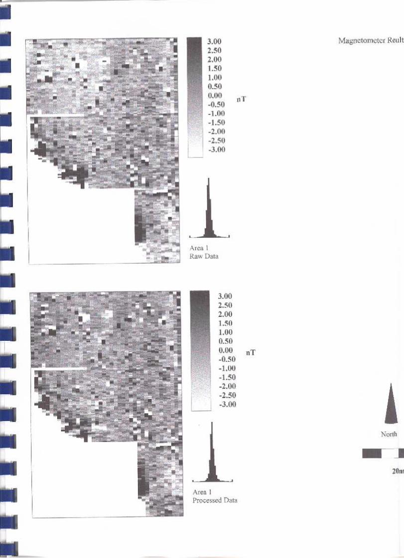
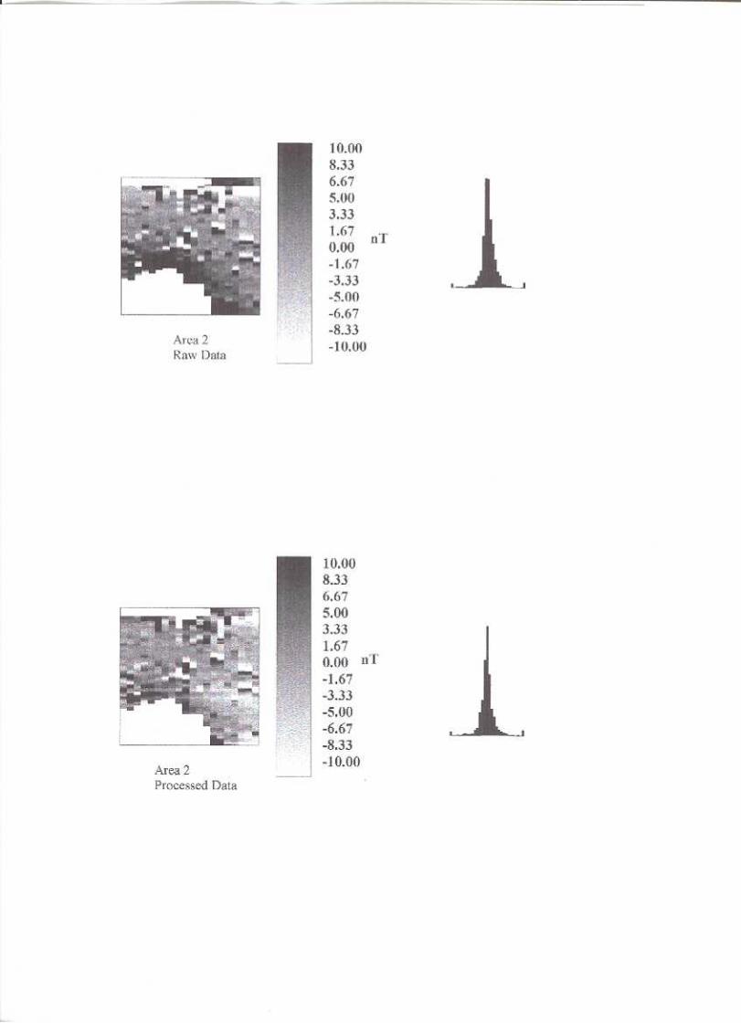
A hedge containing a chain link fence meant that the site was split into two parts: Areas 1 and 2 (Fig. 2). In
order to carry out the surveys it was necessary to define two meshes within which the surveys would be carried
out. One mesh was laid out in each of the areas. Meshes are built up from smaller components known as grids.
Each grid measured 20m x 20m. In Area 1, five grids made up the mesh while in Area 2 only one grid was
needed to cover the available area.
The gradiometer survey was carried out using a Geoscan Research FM36 Fluxgate Gradiometer fitted with
an automatic sample trigger to record readings. Each grid was surveyed by along parallel transects at 1m
separation, with readings logged at 0.25m intervals. At the end of each grid the sensor alignment of the
instrument was checked and a tilt error of below +/- 2nT per +/- 2° tilt was maintained.

3
The resistivity survey was completed using a Geoscan Research RM 15 Advanced resistivity meter. The
instrument was set up using a twin probe array spaced at 0.5m. The same transects were used as in the previous
survey except that they were walked in a zigzag fashion and readings were logged at intervals of 1m.
The overgrown nature of parts of the site made it impossible to take accurate readings over the whole
investigation area. On completion of the surveys the data were downloaded and processed using the Geoplot 3.0
(Beta) software (Geoscan 2000).
Results (Fig. 3)
The resultant plots show raw data and processed data from both surveys. The data from both surveys underwent
the same processing. Firstly, a process known as ‘de-spiking’ was carried out. This removes single anomalous
readings, which are due to modern metallic debris within the soil and may influence further processing. The
second process carried out on the data is known as ‘Zero Mean Traverse’. This process sets the background
mean of each traverse to zero and is useful for removal of stripping effects. No other processing was applied to
the data.
The resultant plots show no anomalies that could be derived from archaeological deposits or features.
Conclusion
Both surveys produced negative results with no archaeological anomalies being detected. However, this does not
mean that the site is devoid of archaeology and the survey should not be considered as the definitive
investigation of the site.
References BGS, 1971, British Geological Survey, 1:50 000, Sheet 268, Solid and Drift Edition, Keyworth English Heritage, 1995, Geophysical survey in archaeological field evaluation, Research and Professional
Services Guideline No. 1, English Heritage, London Gaffney, C, Gater, J and Ovenden, S, 2002, The use of Geophysical Techniques in Archaeological Evaluations
Institute of Field Archaeologists paper no 6 Geoscan 2000, Geoplot Version 3.00 for windows, Instruction Manual Hindmarch, E, 2002, ‘Blandford Hythe, Brimpton Road, Brimpton, West Berkshire, an Archaeological
Evaluation’, Thames Valley Archaeological Services Report 02/63b Lobb, S and Rose, P, 1996, Archaeological Survey of the Lower Kennet Valley, Berkshire, Wessex Archaeology
report 9, Salisbury PPG16, 1990, Archaeology and Planning, Dept of the Environment Planning Policy Guidance 16, HMSO

4

5

6