brookland/cua metro station small area plan · district of columbia adrian m. fenty, mayor dc offi...
TRANSCRIPT

Government of the District of Columbia Adrian M. Fenty, Mayor
DC Offi ce of Planning Harriet Tregoning, Director
Bay Area Economics Gorove/Slade Associates Justice & Sustainability Associates Robinson & Associates A. Morton Thomas Associates
B r o o k l a n d / C U A M e t r o S t a t i o n
S m a l l A r e a P l a nW a s h i n g t o n , D C
D e c e m b e r , 2 0 0 8R 1 8 - 0 0 3 2 A p p r o v e d b y C o u n c i l M a r c h 3 , 2 0 0 9


Brookland / CUA Metro Station Small Area Plan Table of Contents
BROOKLAND / CUA METRO STATION SMALL AREA PLAN
Washington, DCNovember, 2008
TABLE OF CONTENTS
EXECUTIVE SUMMARY.....................................................................................................................................................................................................1
1. INTRODUCTION..............................................................................................................................................................................9
2. EXISTING CONDITIONS ANALYSIS SUMMARY...................................................................................................................13
3. GUIDING PRINCIPLES ................................................................................................................................................................33
4. SMALL AREA PLAN......................................................................................................................................................................36
5. SUB-AREA PLANS.........................................................................................................................................................................40
6. RECOMMENDATIONS AND IMPLEMENTATION.................................................................................................................50
ACKNOWLEDGEMENTS................................................................................................................................................................................................66
APPENDIX A NOTES ON THE PLANS.............................................................................................................................................................A1
APPENDIX A1 CONCEPT PLAN ALTERNATIVES.......................................................................................................................................A1-1
APPENDIX B EXISTING CONDITIONS.............................................................................................................................................................B1
APPENDIX C TRANSPORTATION STUDY........................................................................................................................................................C1
APPENDIX D MARKET ANALYSIS.....................................................................................................................................................................D1
LIST OF FIGURES
Fig. 1 Small Area Plan illustrative drawing
Fig. 2 Small Area Plan illustrative drawing
Fig. 3 Concept diagram
Fig. 4 Metro Station sub-area framework plan
Fig. 5 Monroe Street sub-area framework plan
Fig. 6 12th Street sub-area framework plan
Fig. 7 Commercial north sub-area framework plan
Fig. 8 Commercial south sub-area framework plan
Fig. 1.1 Bird’s eye view of Metro Station
Fig. 1.2 Location map
Fig. 2.1 Regional plan
Fig. 2.2 Brookland aerial photo
Fig. 2.3 Aerial photo with Small Area Plan boundaries

Brookland / CUA Metro Station Small Area Plan Table of Contents
Fig. 2.4 Market study and transportation study boundary map
Fig. 2.5 Existing Conditions Plan
Fig. 2.6 Figure-ground diagram of the Brookland neighborhood
Fig. 2.7 Existing zoning map
Fig. 2.8 Existing land use map
Fig. 2.9 Existing Open Space
Fig. 2.10 Sub-areas key plan
Fig. 2.11 Metro Statio sub-area existing conditions plan
Fig. 2.12 12th Street existing conditions plan
Fig. 2.13 12th Street existing conditions plan (cont’d)
Fig. 2.14 Monroe Street sub-area existing conditions plan
Fig. 2.15 Commercial Area North sub-area existing conditions plan
Fig. 2.16 Commercial Area South sub-area existing conditions plan
Fig. 2.17 Transportation study area map
Fig. 3.1 Land Use and Neighborhood Character concept diagram
Fig. 3.2 Economic Development and Neighborhood Amenities concept diagram
Fig. 3.3 Transportation, Walkability and Connectivity concept diagram
Fig. 3.4 Open Space, Open Space and Environment concept diagram
Fig. 4.1 Concept Diagram
Fig. 4.2 Small Area Plan illustrative drawing
Fig. 4.3 Concept diagram
Fig 4.4 Small Area Plan illustrative drawing
Fig. 5.1 Sub-areas key plan
Fig. 5.2 Metro Station sub-area existing conditions plan
Fig. 5.3 Illustrative plan of Metro Station sub-area
Fig. 5.4 Illustrative section 1 of Metro Station sub-area
Fig. 5.5 Metro Station sub-area concept diagram
Fig. 5.6 Metro Station sub-area framework plan
Fig. 5.7 Illustrative plan of Monroe Street sub-area
Fig. 5.8 Monroe Street sub-area existing conditions plan
Fig. 5.9 Illustrative section 2 of Monroe Street sub-area
Fig. 5.10 Illustrative section 3 of Monroe Street sub-area
Fig. 5.11 Illustrative section 4 of Monroe Street sub-area

Brookland / CUA Metro Station Small Area Plan Table of Contents
Fig. 5.12 Concept diagram of Monroe Street sub-area
Fig. 5.13 Monroe Street sub-area framework plan
Fig. 5.14 Existing conditions plan of 12th Street sub-area
Fig. 5.15 Illustrative section 5 of 12th Street sub-area
Fig. 5.16 Illustrative plan of 12th Street sub-area north of Monroe Street
Fig. 5.17 Illustrative plan of 12th Street sub-area south of Monroe Street
Fig. 5.18 12th Street sub-area framework plan
Fig. 5.19 12th Street sub-area concept diagram
Fig. 5.20 Existing conditions plan of Commercial North sub-area
Fig. 5.21 Illustrative plan of Commercial North sub-area
Fig. 5.22 Illustrative section 6 of Commercial North sub-area
Fig. 5.23 Concept diagram of Commercial North sub-area
Fig. 5.24 Commercial North sub-area framework plan
Fig. 5.25 Existing conditions plan of Commercial south sub-area
Fig. 5.26 Illustrative plan of Commercial South sub-area
Fig. 5.27 Commercial South sub-area concept diagram
Fig. 5.28 Commercial South sub-area framework plan
Fig. 6.1 Recommended Traffi c Improvements
Fig. 6.2 Recommended transit improvements
Fig. 6.3 Recommended pedestrian improvements
Fig. 6.4 Recommended bicycle improvements
Fig. 6.5 Recommended area on- and off-street parking improvements
Fig. A.1 Illustrative plan - Brookland Crossing concept
Fig. A.2 Illustrative plan - Brookland Plaza concept
Fig. A.3 Illustrative plan - Brookland Green concept
Fig. A.4 Illustrative plan of Concept Plan A Metro Station area
Fig. A.5 IIustrative plan of Concept Plan A
Fig. A.6 Illustrative plan of Concept Plan B Metro Station area
Fig. A.7 IIustrative plan of Concept Plan B
Fig. A.8 Alternative Metro Station entrance option
Fig. A.9 Metro Station Option 1
Fig. A.10 Metro Station Option 2
Fig. A.11 Metro Station Option 3
Fig. A.12 Concept 1-Raised Deck

Brookland / CUA Metro Station Small Area Plan Table of Contents
Fig. A.13 Enlarged plan of plaza at deck
Fig. A.14 Section AA-Concept 1
Fig. A.15 Section BB-Concept 1
Fig. A.16 Massing study view of plaza looking west along Newton Street-Concept 1
Fig. A.17 Concept 2-Fill and Deck
Fig. A.18 Enlarged plan of plaza at deck
Fig. A.19 Section AA-Concept 2
Fig. A.20 Section BB-Concept 2
Fig. A.21 Massing study view of plaza looking west along Newton Street-Concept 2
LIST OF TABLES
Table 2.1 Market area population and household trends
Table 2.2 Recommended market unit mix and tenure for Brookland
Table 6.1 General recommendations
Table 6.2 Sub-area recommendations
Table 6.3 Transportation recommendations and implementation matrix

Brookland / CUA Metro Station Small Area Plan | 1Executive Summary
Fig. 1 – Brookland/CUA Metro Station Small Area Plan Illustrative drawing
EXECUTIVE SUMMARY
Overview
The Brookland/CUA Metro Station Small Area Plan is a framework plan - the result of an intensive 18-month long community-based planning process. The Plan has been developed for the purpose of guiding the growth, de-velopment and revitalization of under utlized areas within a quarter mile or ten-minute walk of the Brookland/CUA Metro Station, as called for in the 2006 DC Comprehensive Plan:
“The goal of the study is to guide future development in the station vicinity in a manner that respects the low den-sity scale of the nearby residential area (particularly the area along 10th Street NE and east of 10th Street NE), mitigates parking and traffi c impacts, and improves connections to nearby institutions and shopping areas.” UNE-2.6
In addition to the framework, the Small Area Plan study includes conducting an Existing Conditions Analysis, a Historic and Cultural Resources Report, a Market Conditions Analysis, a Transportation Analysis, and a Decking Feasibility Study.
This document conveys a shared vision for the Small Area Plan, records the Guiding Principles that were devel-oped through the community-based planning process, and illustrates the resulting concepts. It includes an imple-mentation strategy with recommenda-tions regarding specifi c elements of the plan. It provides residents, land owners, developers and city offi cials and District agencies with a framework and recom-mendations to guide future develop-ment in the study area.
Small Area Plan Concepts
The urban design concepts of the Brookland/CUA Metro Station Small Area Plan were derived by applying the Guiding Principles developed for the plan to the setting of the neighborhood and context, creating a physical frame-work plan. These Guiding Principles are grouped into four categories: Land Use and Neighborhood Character; Econom-

Brookland / CUA Metro Station Small Area Plan2| Executive Summary
ic Development and Neighborhood Amenities; Transportation, Walkability and Connectivity; and Open Space and Environment.
Land Use and Neighborhood
CharacterThe Small Area Plan proposes new moderate density mixed use develop-ment in key subareas, including the Metro Station and Monroe Street. New development should create active pedestrian friendly neighborhoods and provide a variety of housing types for all income levels.
To achieve these land use and zoning changes, property owners or develop-ers will be required to apply for dis-cretionary approval of Planned Unit Developments or a zoning map amend-ment. A full discussion of these tools is included in the Small Area Plan Section.
The Metro Station is envisioned to become a mixed-use, transit-oriented and civic core for the community, with the arts as a key element. A new Civic Plaza and Open Space is proposed at the Metro Station along an extension of Newton Street, and is integrated with Brooks Mansion. It is the place for community gathering and interaction, cultural and arts activities, and for the Brookland Farmers Market. Residential units above the retail overlook the plaza.
The plan envisions the relocation of the two Metro Station portals slightly south of their current location to align with Newton Street bringing residents and visitors to activate the plaza and to sup-port the new development at the Metro station, Monroe Street, and12th Street. The openness along Newton Street at the Station will maintain views toward the National Shrine of the Immaculate Conception from the east.
Brooks Mansion, and the Open Space around it, are envisioned to become an important green civic element for the community in the future. It could serve as a community building such as a community center or library, while its Open Space could become a commu-nity park space.
Monroe Street is the primary gate-
way and connector between the east and west sides of Brookland. A Open Space and plaza are proposed for Monroe Street at its intersection with Michigan Avenue, creating a western gateway to the neighbor-hood. Monroe Street is envisioned as a tree-lined mixed-use street, with neighborhood-serving retail, restau-rants, arts and cultural uses on the ground floor, and residential above.
Components of Catholic University’s arts programs, as well as neighbor-hood arts organizations such as Dance Place could become cultural ameni-ties along Monroe Street, potentially establishing a Brookland Arts District. Collaboration between area universi-ties and local arts organizations to implement the Brookland Arts District
is strongly encouraged.
12th Street is envisioned as the strengthened Main Street of Brookland and the focus of mixed-use infi ll devel-opment. Implementation of proposed streetscape improvements, additional infi ll mixed-use development, and im-proved connectivity with Monroe Street and the Metro Station will enhance businesses and the civic life of 12th Street.
Economic Development and
Neighborhood AmenitiesThe Small Area Plan proposes new mixed-use and residential development to bring people to the neighborhood, and to provide needed neighborhood retail, amenities and services.
The Metro Station area will include resi-
Brookland/CUA Metro Station Small Area Plan
Guiding Principles
Land Use and Neighborhood Character
Protect existing neighborhood character;• Highlight neighborhood historic and cultural resources;• Create an active pedestrian neighborhood with mixed-use development • and a variety of housing types for all income levels;Provide civic and cultural amenities;• Promote quality in design of buildings and public spaces.•
Economic Development & Neighborhood Amenities Strengthen and support the 12th Street Main Street commercial core;• Add new retail and businesses to compliment 12th Street and provide • needed services;Acquire services from and provide jobs for local residents;• Create an enhanced civic infrastructure and support local schools;• Create opportunities for cultural events and public art;• Enhance the public realm by addressing safety and cleanliness issues.•
Transportation, Walkability and Connectivity
Address traffi c impacts and protect the neighborhood from additional • traffi c;Promote and integrate bus, shuttles, bikes, rail and other transit options;• Provide adequate parking while in keeping with Transit-Oriented • Development principles;Improve east-west connectivity across the neighborhood; • Improve walkability around the neighborhood and connectivity to Metro • and 12th Street;Enhance the public realm through improved streetscape, way fi nding, • lighting, landscaping and burying of utilities.
Open Space and Environment Guiding Principles
Improve and maintain existing park spaces;• Increase Open Space throughout the neighborhood;• Improve and maintain street trees and plantings; • Employ sustainable building and site design strategies; •
Note 4 (See Appendix)*

Brookland / CUA Metro Station Small Area Plan | 3Executive Summary
accommodate vehicles or be limited to pedestrians. The connection could also be made via the Metropolitan Branch Trail. The Small Area Plan also proposes improved east-west connec-tivity across the neighborhood and to 12th Street primarily along a revital-ized Monroe Street. It further includes the integration of the Metropolitan Branch Trail on the west side of the CSX/Metro tracks along 8th Street and John McCormack Road.Open Space and EnvironmentNew public spaces, open spaces, ad-ditional pocket parks and civic plazas are envisioned for the Metro Station area and along Monroe Street. Specifi c areas include Monroe Street, west of 7th Street; along Newton Street between 9th and 10th Streets, at Brooks Mansion, with a future active community open space or park to include the current parking lot, and in the Commercial North sub-area, a new park central to the new residential development.
Sidewalks should include open space potentially in the form of continuous tree and planting areas. Improved streetscape including paving, light-ing and trees should be implemented with all new development. Open spaces and new street trees, made possible by the under grounding of utilities, are envisioned to be part of every new development.
New development will be subject to the requirements of the DC Green Building Act of 2006. In concert with this, buildings should be sited for the best solar orientation, wherever pos-sible, to maximize energy effi ciency. Green strategies for on-site storm water management should be imple-mented with each new development and any new buildings, public spaces, roadways and infrastructure.
Sub-Areas
The Small Area Plan focuses on under utilized areas in and surrounding the Metro Station which are within a quar-ter of a mile of the station. These sub-areas include the station itself, Monroe Street between Michigan Avenue and 12th Street, 12th Street itself, and the commercial areas north and south of
dential units above neighborhood-serv-ing retail together with public spaces for community gathering and interac-tion. Monroe Street will be lined with a mix of uses, including retail, restaurants, arts and cultural uses on the ground fl oor, and residential above stores west of the tracks, infi ll and redevelopment east of the tracks to 12th Street. 12th Street will be the focus of mixed-use infi ll development.
The commercial areas north and south of the Metro station are envisioned as new residential and small offi ce ar-eas. The commercial area north of the station would include new streets and blocks that extend the existing fabric of the neighborhood. Residential units, consisting of townhouses and apart-ments or condominiums, compatible with the existing neighborhood, would taper down in height toward existing residential. The commercial area south of the Metro Station would include ad-ditional residential and cultural devel-opment, compatible with the neighbor-ing residential area.
Transportation, Connectivity,
WalkabilityThe Small Area Plan proposes strate-gies to create better and more effi cient pedestrian and vehicular connectivity and linkages to neighborhood destina-tions. Reestablishing the fabric and grid of streets and blocks through street extensions and realignments, wherever possible, will reconnect the neighbor-hood by allowing for better circulation around the neighborhood and better pedestrian connectivity.
Street extensions include 8th Street, 9th Street, Newton Street, Perry Street, Kearney Street, and Lawrence Street. Street realignments include 7th Street at Michigan Avenue, 8th Street with John McCormack Road at Michigan Avenue, and Monroe Street at Michi-gan Avenue.
The draft plan supports connectivity between Monroe Street, Michigan Av-enue and 8th Street. That connectivity can take many forms. The conceptual plan shows an extended 8th Street that connects Monroe and Michigan Avenue; an extended 8th Street could
the station along the tracks.
Proposed zoning changes or planned unit developments that are consistent with this small area plan are discretion-ary and require separate approval by the District’s Zoning Commission. Each application requires public notifi ca-tion, as well as review by the aff ected Advisory Neighborhood Commission. The next pages summarize the vision, framework plan, recommendations and development opportunities envisioned for the sub-areas.
Fig. 2 Small Area Plan
Note 6 (See Appendix)*
Note 3 (See Appendix)*

Brookland / CUA Metro Station Small Area Plan4| Executive Summary
Small Area Plan
Concepts Summary
Land Use and Neighborhood Charac-
ter
Mixed-use transit-oriented commu-• nity civic core with arts elements;Community civic plaza and Open • Space at Metro station and Newton Street;Relocated Metro entrances to activate • plaza;Views to National Shrine;• Brooks Mansion as future civic build-• ing, and its Open Space integrated with civic plaza;Monroe Street as primary east-west • connector with mixed-use develop-ment;12th Street as revitalized and • strengthened main street for Brook-land.
Economic Development and Neigh-
borhood Amenities
Mixed-use transit-oriented • develop-ment.Strengthened 12th Street core;• Redeveloped Metro station with a mix • of uses;Mixed-use redevelopment along • Monroe Street from Michigan Avenue to 12th street;Infi ll and redevelopment opportuni-• ties along 12th street;Residential uses north and south of • the Metro Station.
Transportation, Walkability and Con-
nectivity
Restoration of street fabric through • extensions and realignments of streets;Monroe Street as strengthened east-• west connector; Gateways and arrival points along • Monroe Street at Michigan Avenue and 12th Street;Integration of Metropolitan Branch • Trail west of the tracks.Defi ne Monroe, Otis and Newton • Streets between 12th Street and the Metro Station as a walkable and invit-ing connection between the station and the commercial area.
Open Space and Environment
New plaza and open space at Metro • station along Newton Street. Brooks Mansion as civic building • and open space;New open spaces integrated into • new development;Use of green building techniques • and site design. Fig. 3 - Concept diagram

Brookland / CUA Metro Station Small Area Plan | 5Executive Summary
Metro Station Sub-Area
Vision:
Metro Station as a new mixed-use transit-oriented civic core for Brookland.
Framework Plan:
Reestablished street fabric through • extensions, realignments, and recon-nections of streets;
Mixed-use development including • community-serving retail and resi-dential surrounding public spaces;
Metro Station entries relocated to • align with Newton Street and inte-grated with public spaces;
Public spaces for civic and cultural • activities, community gathering and the Farmers Market at Newton Street and at Metro portal, Newton Street integrated with Brooks Mansion;
Busses, shuttles, kiss ‘n ride and • short-term parking integrated with street grid.
Recommendations:
Develop a moderate-density mix 1. of uses including retail, offi ce, residential and cultural uses at the Metro Station.
Provide adequate parking but at 2. low transit-oriented development parking ratios.
Add streetscape improvements to 3. Otis and Monroe Streets emphasiz-ing the connections to the station and the commercial area.
Defi ne Otis and Newton Streets 4. between 12th Street and the Metro Station as a walkable and inviting connection between the station and the commercial area.
Use streetscape enhancements and 5. signage to create more identifi -able and inviting pedestrian (and vehicular) connections from the 12th Street commercial corridor to the Brookland/CUA Metro Station along Newton and Otis Streets.
Place bus routes on the street grid 6. with bus stops along 9th Street.
Kiss ’n ride, short-term parking 7.
Fig. 4 – Metro Station sub-area framework plan
MM
along 9th and Newton Streets.
Work with the Offi ce of Property 8. Management on the design and accessibility of the open space surrounding the Brooks Mansion creating a community civic and open space along Newton Street, integrated with Brooks Mansion and it’s grounds.
Develop a shuttle consolidation 9. strategy to implement a more effi-cient shuttle pick-up and drop-off system.
Create a community civic and Open 10. Space along Newton Street, inte-grated with Brooks Mansion and its grounds.
Relocate the Metro Station portals 11. so that they align with Newton Street.
Develop low-density residential 12. along the west side of 10th Street between Otis Street and Newton Street; alternatively utilize this area as an expanded open space to tran-sition to the lower scale residential area east of 10th Street. Diagrams illustrating this option are included in the Appendix A Concept Alterna-tives, fi gure A.3.
Work with residents, local busi-13. ness, cultural and civic associations to program activities, such as the weekly Farmers Market, and arts/cultural exhibits and performances at neighborhood public spaces.
Development up to 6 stories or a 14. maximum 70 feet may be allowed through a Planned Unit Develop-ment, a discretionary approval by the District’s Zoning Commission.
WMATA will resume its transporta-15. tion access study for the Brookland Metro station to fully assess the recommendations in the draft plan and their impact on transit service delivery. WMATA representa-tives participated in the planning process and served on the advisory committee. The Offi ce of Planning anticipates that the coordination and engagement between WMATA, the District, and the community will continue when the access study
resumes.
Building facades facing a public 16. street in the sub area should step back in height at a ratio of one half (1/2) to one above 50 feet.
Building facades along Newton 17. Street and the Metro Plaza should step back in height at a ratio of one to one above 50 feet in order to preserve views to the Basilica of the National Shrine of the Immaculate Conception.
Development Opportunity:
Residential 200-250 units;• 30-35K Retail/Restaurant/Cultural;• 220-265 parking spaces.•
Note 2 (See Appendix)*
Note 5 (See Appendix)*

Brookland / CUA Metro Station Small Area Plan6| Executive Summary
Fig. 5 – Monroe Street sub-area framework plan
Monroe Street Sub-Area
Vision:
Monroe as a revitalized, tree-lined ur-ban street, connecting Brookland from west to east with retail, residential and cultural and arts uses.
Framework Plan:
Reestablished street fabric through • extensions, realignments, and recon-nections of streets.
Mixed-use development with • community-serving retail, residen-tial, cultural uses and public spaces along Monroe Street from Michigan Avenue to 12th Street to connect Brookland from west to east.
A gateway to Brookland at Monroe • Street and Michigan Avenue, and an arrival point at Monroe Street and 12th Streets.
Civic and Open Spaces west of tracks • and at Brooks Mansion.
Recommendations:
Realign Monroe Street with Michi-1. gan Avenue at western end.
Realign 7th Street north of Monroe 2.
Street at Michigan Avenue with entrance to Catholic University.
Extend 8th Street for pedestrian 3. and/or vehicular access north of Monroe Street to align with John McCormack Road at Michigan Avenue.
Develop a moderate-density mix 4. of uses along Monroe Street west of the WMATA/CSX tracks with com-munity-serving retail, residential, cultural uses and public spaces.
Provide adequate parking but at 5. low transit-oriented development parking ratios.
Development along Monroe Street 6. west of the WMATA/CSX tracks may be allowed up to 6 stories or a max-imum 70 feet through a Planned Unit Development, a discretionary approval by the District’s Zoning Commission. Building heights should taper down to transition to adjacent lower scale residential structures.
Allow infi ll and redevelopment 7. along Monroe Street east of the WMATA/CSX tracks.
Development along Monroe Street 8.
east of the WMATA/CSX tracks may be allowed up a maximum 50 feet through a Planned Unit Develop-ment, a discretionary approval by the District’s Zoning Commission.
Development should provide visual 9. and noise buff ers from train tracks and neighboring production, distri-bution, and repair (PDR) uses.
Coordinate a retail strategy to 10. encourage complimentary retail and businesses for both 12th and Monroe Streets.
Create a large civic Open Space as 11. part of new development along Monroe Street west of the WMATA/CSX tracks.
Reposition Brooks Mansion as a 12. community civic building and its grounds as a civic/Open Space. Consider removing the surface parking area to reclaim additional Open Space and integrate with the Newton Street public space.
Development Opportunity:
Residential 750-900 units; • 80-100K Retail/Restaurant/Cultural;• 650-850 parking spaces.•

Brookland / CUA Metro Station Small Area Plan | 7Executive Summary
Fig. 6 – 12th Street sub-area framework plan
blending with the design and scale of the street. Development along 12th Street may be allowed up to a maxi-mum of 50 feet. Between Otis Street and Randolph Street and between Monroe and Rhode Island Avenue, additional height up to 50 feet may be allowed through a Planned Unit Devel-opment, a discretionary approval by the District’s Zoning Commission.
4. Coordinate a retail strategy to encourage complimentary retail and businesses for both 12th and Monroe Streets. Defi ne and strengthen 12th street as a unique shopping destination.
5. Create distinct branding and mer-chandising strategies for 12th Street and Monroe Street. Monroe Street should be recognized for larger-format, mixed-use off erings, and 12th street as boutique/specialty goods and services.
6. Include way fi nding techniques to in-dicate the character of the 12th St. and Monroe Street corridors, help ensure free movement of shoppers and pe-destrians between them, and facilitate access from the Metro.
7. Investigate the viability of a creative economy cluster on 12th Street, build-ing on current assets, specialty retailers or cultural assets.
8. Retain existing retailers and seek new fi nancing options to help small, local businesses manage economic pressures. The neighborhood invest-ment fund is an example of the type of resource that can be used to assist small business.
9. Work with District government agen-cies, the business community and busi-ness organizations to establish store-front design guidelines for businesses along 12th Street. Focus on revitalizing bland building facades and inconsistent building frontage.
Development Opportunity
Commercial core of 12th Street • between Monroe and Randolph Streets;
Residential and some commercial • infi ll north of Randolph Street and south of Monroe Street.
12th Street Sub-Area
Vision:
12th Street as Brookland’s revitalized and strengthened) commercial district and historic area..
Framework Plan:
Improved connectivity to western • part of Brookland and Metro station along Newton and Monroe Streets;
New streetscape, landscape, lighting, • and storefront improvements;
Infi ll, redevelopment and revitaliza-• tion opportunities for retail, offi ce,
and residential.
Recommendations:
1. Develop mix of uses including retail, offi ce, residential and cultural uses as redevelopment and infi ll development along 12th Street.
2. Enliven the intersection at 12th and Monroe Street. Create an authentic community gathering spot that blends the main street feel from 12th street, surrounding residential and institu-tional uses on Monroe Street. Consider uses that compliment existing retail.
3. Increase infi ll development while

Brookland / CUA Metro Station Small Area Plan8| Executive Summary
Fig. 7 – Commercial North sub-area framework plan
Fig 8 - Commercial South sub-area framework plan
Commercial Area North of Metro Station Sub-Area
Vision:
New residential and small offi ce area woven into neighborhood fabric.
Framework Plan:
Reestablished street fabric through • extensions, realignments, and recon-nections of streets;
New residential and small offi ce uses • along a fabric of streets and blocks;
New central Open Space surrounded • by residential.;
Buff ering and screening from tracks • and PDR (Production, Distribution and Repair) uses.
Recommendations:
Extend Perry Street west and 9th 1. Street north to create a new fabric of streets and blocks.
Development north of an extended 2. Perry Street should consist of low to moderate density residential development.
Develop new residential and small 3. offi ce uses, created along a fabric of streets and blocks, extending and integrating with the existing neighborhood character.
Create a community open space 4. as part of development in this sub-area.
Provide adequate parking but at 5.
low transit-oriented development parking ratios.
Provide new streetscaping, land-6. scaping and lighting.
Development between Michigan 7. Avenue and an extended Perry Street may be allowed up to 6 sto-ries or a maximum 70 feet through a Planned Unit Development, a discretionary approval by the Dis-trict’s Zoning Commission. Build-ing heights should taper down to transition to adjacent lower scale residential structures.
Building facades facing a public 8. street in the sub area should step back in height at a ratio of one half (1/2) to one above 50 feet. For example, for every 10 feet in height above 50 feet, the building facade should step back 5 feet from the building edge.
Development should provide visual 9. and noise buff ers from train tracks and neighboring production, distri-bution, and repair (PDR) uses.
Development Opportunity
Residential condominiums/apart-• ments/townhouses – 400-500 units; 20,000 sf of offi ce space;• 200-330 parking spaces.•
Commercial Area South of Metro Station Sub-Area
Vision:
New residential and cultural uses woven into the neighborhood street fabric.
Framework Plan:
New residential infi ll including artists • housing and cultural facilities;
Improved streetscape, landscape and • lighting;
Integration of Metropolitan Branch • Trail;
Buff ering and screening from tracks • and PDR uses.
Recommendations:
Develop new residential uses, 1. extending and integrating with the existing street fabric.
Development south of Kearny 2. Street should consist of low to moderate density residential and limited commercial or cultural facilities.
Provide adequate parking but at 3. low transit-oriented development parking ratios.
Development south of Monroe 4. Street to Kearny Street may be allowed up to 5 stories or a maxi-mum of 60 feet through a Planned Unit Development, a discretionary approval by the District’s Zoning Commission. Building heights should taper down to transition to adjacent lower scale residential structures.
Building facades facing a public 5. street in the sub area should step back in height at a ratio of one half (1/2) to one above 50 feet. For example, for every 10 feet in height above 50 feet, the building façade should step back 5 feet from the building edge.
Integrate Metropolitan Branch Trail 6. along 8th Street.
Development Opportunity:
Residential - 150-200 units;• Arts and cultural uses;• 75-100 parking spaces.•

Brookland / CUA Metro Station Small Area Plan | 9Introduction
1. INTRODUCTION
For a variety of reasons, the coming decade will likely be a time of rapid change in our city. As a nation, Ameri-cans are entering uncharted territory. Infl ation-adjusted energy prices are higher than they have ever been and while experts are divided, many pre-dict prices will steadily climb for the foreseeable future, based on steady or dwindling supplies and growing global demand.
While traffi c and concerns about car movements have been dominating issues in the development of this plan, as is true for many plans underway around the city, we think travel behav-ior is poised to change signifi cantly. Admittedly, we cannot accurately predict exactly how that behavior will change. We have no past behavior in the US to look back upon to help us forecast how our citizens will choose to travel, or how many trips they will now take, or where and how they will now want to live. However, it is already clear that higher energy prices are shifting some trips from single occu-pancy vehicles to transit, walking or biking.
After growing inexorably for decades, our region is already seeing a historic decrease in vehicle use (down nearly 4% since last year). At the same time, the recent diffi culties in the home mortgage industry have revealed the relative strengths and weakness of home values in the region. Neighbor-hoods like Brookland with develop-ment around transit have fared much better, with auto-dependent com-munities enduring steep declines. We are already seeing changes in housing preferences.
Commuting up to two hours a day is demanding enough. But as people realize a close-to-the center residence is cheaper than a far away home plus commuting, people are newly weigh-ing their alternatives.
Transit use in the Washington, DC region is rapidly increasing (up nearly 4% since July of last year), with 5 of the past 10 peak ridership days in Met-ro history occurring in the past year. Nationally, transit use has reached a 50-year high and is climbing, up 30% or more in some communities around the country.
Before cars became so dominant on our roads, people traveled (and kept
fi t) by meeting the demands of daily life, largely on foot. Today, more than 40% of all car trips taken are 3 miles or less – short trips that might be more likely to shift to another mode. As people increasingly look at the cost of driving to a store or event as they decide how to travel, more of them may opt to bike, walk, or take transit. Walkability is becoming the sine qua non of a livable community.
Brookland is well poised to take advantage of changing transit prefer-ences to create a vibrant, attractive and walkable commercial district and neighborhood. Currently, diff erent parts of the neighborhood experience varying levels of amenities. Accord-ing to a recently developed measure to understand walkability called Walk Score, the larger Catholic University-Brookland area is considered moder-ately walkable and gained 61 out of 100 points possible. This means that only some stores and amenities are within walking distance for residents. In comparison, other District neigh-borhoods such as Dupont Circle or the U Street area have a Walk Score of 99 and 97, respectively.
Fig. 1.1 – Bird’s eye view of Metro Station and surroundings (source: Windows Live)

Brookland / CUA Metro Station Small Area Plan 10| Introduction
Within the Brookland neighborhood there are variances in accessibility to amenities and transit options. For example, areas around the metro have a very high Walk Score, averaging around 83 out of a 100 and considered ‘very walkable’. Areas farther away from the Metro have lower scores and are considered ‘car dependent’ 1. This means that residents in low-walkable areas cannot run errands or perhaps buy groceries in their immediate neighborhood. An important goal is to give all Brookland residents the op-portunity to shop and recreate close to their homes.
With more people out of their cars and in the neighborhood, increased foot traffi c will support local businesses who can better off er convenient goods and services to residents. Also, more dense and walkable neighborhoods attract and sustain a diversity of retail, which makes neighborhood shopping for items previously only available outside the area a reality.
Promoting walkability and enhanced retail opportunities is possible in Brookland, and the area is seeing a resurgence of activity. In the mid 20th century the Brookland population of nearly 11,000 supported a thriving main street, engaged in institutional off erings, and enjoyed a cohesive community. 2 As people moved out of the District starting around 1960,
neighborhoods suff ered. The current Brookland population of just over 6,000 has begun to see a resurgence of new activity. The area maintains the infrastructure and design to sup-port new residents. As more people become interested in Brookland, the neighborhood will be able to meet many more development goals, in-crease amenities and enrich the com-munity spirit.
The intimate connection between the changes happening in our region, elsewhere in the United States, and around the globe have true impacts in our communities. Energy, climate and environmental concerns will increas-ingly shape development preferences and goals for the types of uses and transit options that are desired by communities; our own choices of how we grow and develop, what form that growth takes, and the choices we make also will have their impact on climate, energy demand, and the environment.
This inter-relationship underscores how important it is to make sure our neighborhoods contain the services and amenities that allow our citizens to meet their daily needs in their neighborhoods and provide them real and economical choices about how they travel to work, school and play.
Overview
The Brookland/CUA Metro Station Small Area Plan is a community-based plan developed for the purpose of guiding the growth, development and revital-ization of under utilized areas within a quarter mile, or ten-minute walk, of the Metro Station. As areas of the city grows, under utilized land, especially at and near Metro Stations, is under pres-sure for redevelopment. This document serves as a framework for guiding that future growth.
The Small Area Plan document conveys a shared vision for the neighborhood, records the Guiding Principles that were developed through the community-based planning process, and illustrates the resulting concepts. It includes an implementation strategy for transform-ing the plan into reality with recom-mendations regarding specifi c issues. It provides residents, land owners, stake-holders, developers and city offi cials and agencies with a framework and recommendations for guiding future development in the study area.
Goals of the Area PlanThe 2006 DC Comprehensive Plan estab-lished goals and policies for develop-ment and revitalization in the District of Columbia. The Comprehensive Plan specifi cally calls for the development of a Small Area Plan for the Brookland
Commercial Area - South
Commercial Area - North
Monroe Street
Brookland/CUA Metro Station
12th Street NE
1 www.walkscore.com 2 Information for the Brookland Study Area: www.census.gov

Brookland / CUA Metro Station Small Area Plan | 11Introduction
Neighborhood:
“The goal of the study is to guide future development in the station vicinity in a manner that respects the low den-sity scale of the nearby residential area (particularly the area along 10th Street NE and east of 10th Street NE), mitigates parking and traffi c impacts, and improves connections to nearby institutions and shopping areas.” UNE-2.6
The Brookland/CUA Metro Station Small Area Plan incorporates the goals stated for the neighborhood in the Comprehensive Plan as well as the goals derived through the community and stakeholder-driven planning process. The following is a summary of the goals of the Small Area Plan:
Neighborhood Character
Protect the existing residential char-• acter of Brookland;Highlight local historic and cultural • resources.
Neighborhood Shopping
Improve neighborhood shopping • with community-serving retail;Enhance 12th Street retail.•
Development and Land Use Changes
Encourage moderate-density mixed-• use development on vacant and under utilized properties;Support long-term land use changes • on industrially zoned land in the station vicinity, particularly in the area immediately north of Michigan Avenue and in the area to the south-west along 8th Street.
Connectivity
Improve pedestrian safety and access • to the Metro station, particularly eastward along Monroe Street (link-ing to the 12th Street NE shopping area) and Michigan Avenue (linking to Catholic University).
Transportation
Retain the number of bus bays at the • station;Develop strategies to deal with over-• fl ow parking and cut-through traffi c in the station vicinity;Reduce heavy truck traffi c on resi-• dential streets-Taylor Street NE, 8th
Fig. 1.2 – Location Map (Source: DC GIS)
Maryland
Virginia
Marylan
dStreet NE.
Buff ering
Reduce the eff ects of excessive noise • and vibration from the CSX/Metro tracks on the neighborhood.
Open Space
Incorporate parks and open space • in institutional and other redevelop-ment;Address shortage of parkland in the • southwest part of Brookland.
Planning ContextThe Brookland/CUA Metro Station Small Area Plan was prepared in re-sponse to the 2006 DC Comprehensive Plan which states:
“Action UNE-2.6-A: Brookland Metro Small
Area Plan: Prepare a Small Area Plan for the Brookland Metro station area to pro-vide guidance on the future use of vacant land, buff ering of existing development, upgrading of pedestrian connections to Catholic University and 12th Street, urban design and transportation improvements, and the provision of additional open space and community facilities in the area. Ensure that community partners such as Catholic University and CSX are involved in this process.”
In addition, there have been a number of previous neighborhood planning eff orts and studies including:
A Historic Survey sponsored by the • Brookland Community Development Corporation, completed in 2001.

Brookland / CUA Metro Station Small Area Plan 12| Introduction
Community Visioning Workshop
Community Workshop Community Walking Tour
Advisory Committee Meeting
A Main Street Business District • designation for 12th Street by DC Main Street in 2003. The goal is to support retail investment in the District through the retention and expansion of existing businesses and the recruitment of new businesses in traditional neighborhood busi-ness districts. DC Main Streets is a program of the Department of Small and Local Business Development and is based on the National Trust for Historic Preservation’s model.
DC’s Industrial Land Use Study: In-• dustrial Land in a Post-Industrial City was completed in 2006. While stating that DC needs areas for industrial and PDR (Production, Distribution, and Repair) uses, it recommends that such areas along the CSX rail and WMATA Red Line near Metro Stations be redeveloped.
In 2007, DDOT completed the Brook-• land Multi-modal Transportation and Streetscape Study which proposed overall roadway and streetscape improvements for the area. The Plan incorporates those improvements.
Upon completion of the Small Area • Plan, WMATA will prepare a Station Access Study for the Brookland/CUA Metro Station, with an in-depth focus
on circulation and pedestrian access to and from the Metro station.
Upon the City Council’s adoption • of the Small Area Plan, the docu-ment will be used to guide the community, developers, and city agencies, in making decisions with regard to proposed development in Brookland.
Process and Methodology
The District of Columbia Offi ce of Plan-ning engaged a multi-disciplinary team to conduct an inclusive, collaborative, community-driven planning process. The team included SmithGroup for ur-ban design, planning and project man-agement, Bay Area Economics for the market study, Gorove/Slade Associates for the transportation study, Justice and Sustainability Associates for community engagement and facilitation, Robin-son and Associates for the historic and cultural resources study, and A. Morton Thomas for cost estimating.
Community Planning Process
Community members and stakehold-ers came together during an inten-sive 18-month long process, which included numerous public meetings and workshops, meetings with resi-dents, land owners, stakeholders, as
well as city agencies and officials. An Advisory Committee was formed to guide the process and its members served as essential participants in the process. The engagement process en-couraged all community members to participate in a forward-thinking and collaborative way.
Project Methodology
The study began with an analysis of the existing conditions around the study area, including fi eld work by the con-sultant team, neighborhood tours and discussions with community members, and an assessment of the urban design and public realm conditions focusing on connectivity issues.
A detailed Existing Conditions Report • was prepared as a separate docu-ment at the beginning of the plan-ning process. A brief summary of that document is found in Appendix of this report.
A Historic and Cultural Resources • Study was prepared detailing the history and cultural highlights of the neighborhood.
A Market Analysis was conducted to • assess the current market conditions in Brookland, and guide the consul-tant team in developing illustrative
Small Area Plan Public Meetings
Walking & Bus Tours:
- December 9, 2006- January 27, 2007- April 21, 2007
Advisory Committee Meetings:
- October 19, 2006- February 1, 2007- March 21, 2007- April 30, 2007 - June 6, 2007- June 19, 2007- July 2, 2007- April 2, 2008
Community Meetings and Workshops:
- November 29, 2006 – Existing Conditions- February 22, 2007 - Land Use, Zoning and Market Analysis - March 8, 2007 - Visioning - April 21, 2007 - Guiding Principles - May 16, 2007 - Concept Alternatives - June 23, 2007 - Draft Concept Plan - July 19, 2007 - Concept Plan Options and Transportation Study - April 26, 2008 - Final Presentation

Brookland / CUA Metro Station Small Area Plan | 13Introduction
plans addressing the future market conditions of the neighborhood. This analysis took into consideration the existing conditions of the neigh-borhood, the historic and cultural resources and a regional view of the market area around Brookland.
A Land Use and Zoning Analysis • was prepared to look at existing and potential densities in the study area. The current density, by-right maxi-mum density and potential increased density for parts of the study area were assessed.
An initial Transportation Conditions • Assessment was conducted as part of the study. Members of the com-munity expressed concerns about the potential impacts of proposed future development in the larger area. The assessment was expanded into a larger, more comprehensive area Transportation Study.
Among the many goals the com-• munity had for the Small Area Plan one was to improve connectivity throughout the neighborhood by restoring the city grid, extending streets, and placing busses on the street grid. A Decking Feasibility Study was undertaken to explore the design and cost of a community-generated concept to deck over the Metro/CSX tracks between Michigan Avenue and Monroe Street.
The consultant team carefully stud-ied the options including a complet-ing design, engineering, transporta-tion, and fi nancial feasibility analyses. The team found that the cost of either proposal was so substantial that it would take a very signifi cant public investment to implement.
The total development cost for the decking option was projected to be $65,213,450 and the cost for the fi ll option estimated at $115,311,900. Because of the projected cost and implication for District funding, the decking was not pursued further in the Small Area Plan.
Base plan information for the Small
Area Plan was derived from GIS (Geo-graphic Information System), from planimetric datasets provided by the DC Geographic Information System (DC GIS) on behalf of the D.C. Offi ce of the Chief Technology Offi cer (OCTO) and participating D.C. government agen-cies. Information on the location of street trees was derived from (DC GIS) database provided by the Casey Trees Foundation and managed by the Dis-trict Department of Transportation and Urban Forestry Administration (UFA).
Report Format
The Small Area Plan is described in the next sections of this report:
Section 2 contains the existing condi-tions analysis summary providing a re-gional and local assessment of zoning, land use and transportation;
Section 3 describes the guiding principles which guided the planning process;
Section 4 describes the overall concepts and urban design elements of the Small Area Plan;
Section 5 describes specifi c plan ele-ments related to each of the sub-areas including the vision, framework plan, recommendations and development opportunity;
Section 6 describes the recommenda-tions and an implementation strategy for the Small Area Plan;
The Appendices contain a summary alternative concepts that were explored as a part of this planning process as well as a report providing the existing conditions analysis. The Appendices also contains a transportation and market analysis

Brookland / CUA Metro Station Small Area Plan 14| Introduction
This page left blank intentionally

Existing Conditions Analysis Summary| 15Brookland / CUA Metro Station Small Area Plan
2. EXISTING CONDITIONS
ANALYSIS SUMMARY
Regional and Local Context
With its diverse, mostly middle class population, and its neighborhood main street lined with small shops, cafes and services, Brookland has many of the advantages of a small town. Homes in varying styles, some with front porches, row houses, and a few low-rise apart-
Fig. 2.1 – Regional plan
ment buildings are found along tree-lined streets.
Brookland is quite unique among the city’s suburbs in that it has served as home to a high concentration of reli-gious institutions – including colleges, religious orders, and service organiza-tions – that were drawn to the area by the strong presence of Catholic Univer-sity.
Homes of Brookland represent a variety
of architectural styles. The vernacular Victorian, Colonial Revival, bungalow, foursquare, and Modernist are some of the styles and forms one can fi nd along the neighborhood’s hilly, shaded streets.
Historically, Brookland had a much larger population than today. In the 1950’s and 60’s over 10,000 residents called Brookland their home. The 1970’s began a steady decline in population from 9,000 to 6,500 at the time of the
±

16| Existing Conditions Analysis Summary Brookland / CUA Metro Station Small Area Plan
Fig. 2.2 – Brookland Aerial Photo

Existing Conditions Analysis Summary| 17Brookland / CUA Metro Station Small Area Plan
Fig. 2.3 – Aerial photo with Small Area Plan boundaries
2000 Census. Population estimates from 2006 show a continued decline in population to 6,285. Potential develop-ment identifi ed in the draft plan would restore Brookland’s population to the levels enjoyed in the 1950’s and ‘60’s.
Brookland is home to a number of large and small institutions. Nearly 60 of these are Catholic. The establishment of Catholic University in Brookland in 1889 encouraged other Catholic institutions to locate in Brookland. They include
Trinity College, the Pope John Paul II Cultural Center, the Mount Sepulchre Franciscan Monastery, among oth-ers. Other local institutions include McMillan Reservoir, several cemeter-ies, and the Armed Forces Retirement Home. Brookland has been shaped both physically and economically by these institutions, and their infl uence continues today.
The neighborhood has several large and small park spaces. Major open spaces include Turkey Thicket, Fort Bun-ker Hill, and Noyes Park. Smaller open areas and Open Spaces dot the neigh-borhood as well. Much of the residential neighborhood in Brookland is within a 5-15 minute walk of the Metro Station. Brookland is generally laid out in a grid of streets and blocks. Major roadways traverse Brookland. Michigan Avenue, which rises into a bridge, crossing the tracks, bisects Brookland into north-ern and southern areas. Similarly, the WMATA/CSX railroad tracks bisect Brookland into eastern and western areas. While the roadways and transit serve as important means of transporta-tion and access to and from Brookland, in certain places they act as a barriers to neighborhood connectivity.
While the Brookland/CUA Metro Sta-tion Small Area Plan study addresses fi ve specifi c areas in the neighborhood which are under pressure for develop-ment, the study is informed by the whole of the Brookland neighborhood and surrounding context. These fi ve sub-areas include the Metro Station, the 12th Street corridor (Rhode Island Avenue to Taylor Street); Monroe Street between Michigan Avenue and 12th Street, and the commercial areas both north and south of the Metro Station.
A detailed existing conditions analysis was prepared at the beginning of the planning process. The results of that analysis are available as a separate document titled Existing Conditions Report: Brookland/CUA Metro Station Area Plan.
±

18| Existing Conditions Analysis Summary Brookland / CUA Metro Station Small Area Plan
±
1. Washington Gateway Retail Center
2. Rhode Island Place
3. Luke C. Moore Senior High School
4. 1386 Bryant Street
5. Emerson Park
6. Irving Street Conference Center
7. Rhode Island Avenue Gateway
8. 1300 Rhode Island Avenue
9. Dakota Crossing
10. The Basilica Lofts
11. McMillan Sand Filtration site
12. University Town Center
13. Fort Totten Park - Phase I
14. Fort Totten Park - Phase II
15. Madeline Gardens
16. Former Fairfi eld Residential Site
17. Apartments at Brookland*
18. Old Soldiers Home Redevelopment
19. Villages at Washington Gateway
20. Yes! Organic Food Market
21. New Retail at Rhode Island Avenue
Fig. 2.4 – Market Study and Transportation Study Boundaries Map
Mmetro
10
Legend
Study Area
Post Office
Police Station
Places of Worship
Library
Landmarks
Independent Schools
Public Schools
Hotels
Hospitals
Gas Stations
Fire Station
University
D.C. Agency
Cultural/Recreational Buildings
Metro Entrance
Proposed, Planned Under Construction & Recently Completed Development

Existing Conditions Analysis Summary| 19Brookland / CUA Metro Station Small Area Plan
Fig. 2.5 – Existing Conditions Plan
Small Area Plan Boundaries
The boundaries of the Small Area Plan study area generally are Taylor Street to the north, 13th Street to the east, Rhode Island Avenue to the south and 7th Street to Michigan Avenue to John McCormack Road to the west.The Market Study and Transportation Study both looked at a larger area, as shown in Fig. A.17. This allowed those analyses to capture information from existing and potential area develop-ments such as the Armed Forces Retire-ment Home, the McMillan Reservoir and the Brentwood Shopping Center.
The fi gure-ground diagram on the next page reveals the pattern of built forms in Brookland today. The residential sections of Brookland have developed along a regular pattern of streets and blocks. Larger swaths of land are oc-cupied by local institutions such as Catholic University. Development along the railway line consists of the Metro Station, large-footprint warehouses and commercial buildings with much impervious surface areas.

20| Existing Conditions Analysis Summary Brookland / CUA Metro Station Small Area Plan
Fig. 2.6 –Figure-ground diagram of the Brookland neighborhood

Existing Conditions Analysis Summary| 21Brookland / CUA Metro Station Small Area Plan
Fig. 2.7 – Existing Zoning Map
LEGENDStudy Area
Zoning District
Overlay Zoning
Recreation Center
Parks
Buildings
Roads
Bridge±
Existing Zoning
The Brookland/CUA Metro Station Study Area is comprised of primarily low density zones including residential, commercial along 12th Street, and commercial/light industrial along the Metro tracks.
C-1 Neighborhood shopping and low density development
C-2-A Low density development, including offi ce, retail, & kinds of residential uses
C-M-1 Low bulk commercial and light manufacturing uses
C-M-2 Medium bulk commercial and light manufacturing uses
D/R-1-B Single-family residential uses for detached dwellings
D/R-5-A Single-family residential uses for detached and semi- detached dwellings
D/SP-1 Medium Density Residential/ Limited Offi ce
GOV Government uses
M General industrial uses
R-1-B Single-family residential uses for detached dwellings
R-2 Single-family residential uses for detached & semi-detached dwelling units
R-4 Single-family residential uses churches and public schools
R-5-A Single-family residential uses for detached and semi-detached dwellings
R-5-D Medium/high density development of general residential uses, including single- family dwellings, fl ats, and apartment buildings

22| Existing Conditions Analysis Summary Brookland / CUA Metro Station Small Area Plan
LegendLow Density Residential Low Medium Density Residential
Medium Density Residential
High Density Residential
Commercial
Transport, Utilities, Communication
Industrial
Mixed Use
Institutional
Federal Public
Local Public
Public, Quasi-Public, Institutional
Parks & Open Spaces
Parking
Roads; Alleys; Median
Transport. Right of Way
Undetermined
Vacant
Primary Study Area
CSX/WMATA Rail Lines
Existing Land Uses
Brookland has a diversity of interde-pendent land uses, characteristic of a pleasant, low-density, pedestrian-scaled residential community. The predomi-nant land uses found in the study area are low-density residential, retail, insti-tutional, transportation/right-of-way, light industrial (PDR)/commercial and parks/open space. In addition, pockets of medium-density residential and cultural uses are found. These uses are supported by the Brookland/CUA Metro station transit node.
The neighborhood character is defi ned by blocks of single family residences. Neighborhood commercial uses, inter-spersed with residential and institution-al uses characterize 12th Street. Light industrial and warehouse uses with large amounts of surface parking defi ne the areas adjacent to the tracks north and south of the Metro station.
±Fig 2.8 – Existing Land Use Map

Existing Conditions Analysis Summary| 23Brookland / CUA Metro Station Small Area Plan
Existing Open Space
According to the District’s Geographic Information System, Brookland has 18.99 acres of park space and 1.67 acres on open space. Turkey Thicket Community Center, Noyes Park and Fort Bunker Hill are the largest park spaces in and around the study area. There are other green areas in the neighborhood including some along the Metro tracks, the area along 10th Street at the Metro Station, and the area around Brooks Mansion. There are also a number of small garden spaces developed by the Greater Brookland Garden Club.
In many areas of the neighborhood, the streetscape and public landscap-ing suff er from lack of continuity and integrity. Most notably, 12th Street is lined with street trees, although their age, condition and maintenance are not consistent from block to block. Planters are located occasionally along the block, but this too is not continuous. Grass strips are found in-consistently along the sidewalks. The Greater Brookland Garden Club has created neighborhood Open Spaces along 12th Street at Monroe Street and Newton Street.
There is a lot of landscaping in and around the Metro station, including trees, bushes and grassy areas near the Michigan Avenue overpass, the “Kiss ‘n Ride” and Brooks Mansion. The condition and maintenance of landscaping in these areas is gener-ally good. The open space at 10th Street between Newton and Bunker Hill road is especially important to the community.
LegendStudy AreaWooded AreasParksRecreation AreasUndeveloped AreasStreet Trees±
Fig. 2.9 – Existing Open Space

24| Existing Conditions Analysis Summary Brookland / CUA Metro Station Small Area Plan
Sub-Areas
The assessment of the existing neighborhood fabric and condition suggested the identifi cation of fi ve sub-areas for study in greater detail. The sub-areas are generally within a 5-minute walk, or quarter-mile of the Metro Station. These areas are distinct due to location, circulation patterns, existing development and redevelop-ment potential.
Metro Station Sub-Area •
Monroe Street Sub-Area •
12th Street NE Corridor Sub Area •
Commercial Area North of the Metro • Station Sub-Area
Commercial Area South of the Metro • Station Sub-Area
Fig. 2.10 – Sub-areas key plan
±
Legend

Existing Conditions Analysis Summary| 25Brookland / CUA Metro Station Small Area Plan
Metro Station Sub Area
±Fig. 2.11 – Metro Station sub-area existing conditions plan
Panoramic view of Metrobus transit center at Metro east entrance
Metro Station Sub-Area
The Metro Station sub-area consists of the WMATA-owned parcels of land east of the station and Metro/CSX tracks, between Michigan Avenue,10th Street NE, and Monroe Street. It does not include the Brooks Mansion. This site includes the station entrance, the bus bays and turn-around, the green area
LEGEND
Recreation Center
Wooded/Grass Area
Street Trees
Sidewalk
Roads
Institutional Uses
Commercial Uses
Low Density Res.
Low Medium Res.
Medium Density Res.
Industrial
Mixed Use
Transpt., Utilit., Comm.
Local Public
Pub. Quasi-Public Instit.
south of the Drew Bridge, the kiss ‘n ride, parking spaces, and the shuttle pick-up area under the Drew (Michigan Avenue) Bridge.
Shuttle drop-off and pick up area

26| Existing Conditions Analysis Summary Brookland / CUA Metro Station Small Area Plan
12th Street Sub Area - North
Legend
Recreation Center
Wooded/Grass Area
Street Trees
Sidewalk
Roads
Institutional Uses
Commercial Uses
Low Density Res.
Low Medium Res.
Medium Density Res.
Industrial
Mixed Use
Transpt., Utilit., Comm.
Local Public
Pub. Quasi-Public Instit.
CVS retail store in Newton Theater
Storefronts along west side of 12th Street
Storefronts along 12th Street
±
Retail corner of 12th Street & Otis Street
Storefronts along 12th Street
Fig. 2.12– 12th Street existing conditions plan
12th Street Sub-Area
This sub-area consists of 12th Street NE from Tay-lor Street to the north, to Rhode Island Avenue to the south. Brookland’s historic Main Street, 12th Street is characterized by a mix of small commer-cial and residential uses. The commercial core of 12th Street lies primar-ily between Monroe and Otis Streets, but addi-tional shops and busi-nesses and found to the north and south.
match line

Existing Conditions Analysis Summary| 27Brookland / CUA Metro Station Small Area Plan
Legend
Recreation Center
Wooded/Grass Area
Street Trees
Sidewalk
Roads
Institutional Uses
Commercial Uses
Low Density Res.
Low Medium Res.
Medium Density Res.
Industrial
Mixed Use
Transpt., Utilit., Comm.
Local Public
Pub. Quasi-Public Instit. ±
Retail along corner of 12th St. and Monroe St.
Brookland Hardware store
Streetscape along 12th Street
12th Street Sub Area - South
Institutions along corner of 12th Street
Fig. 2.13 – 12th Street existing conditions plan (cont’d)
match line

28| Existing Conditions Analysis Summary Brookland / CUA Metro Station Small Area Plan
Monroe Street Sub Area
±Fig. 2.14 – Monroe Street sub-area existing conditions plan
Panoramic view of Monroe Street looking east, to bridge. Catholic University dormitories.
Monroe Street Sub-Area
The Monroe Street Sub-Area consists of the properties along Monroe Street from Michigan Avenue to the west, to 12th Street to the east. West of the tracks, Monroe Street is home to parcels belonging to Catholic University and other property owners. East of the tracks, Monroe Street is home to residences, commercial businesses, restaurants and institutions.
Legend
Recreation Center
Wooded/Grass Area
Street Trees
Sidewalk
Roads
Institutional Uses
Commercial Uses
Low Density Res.
Low Medium Res.
Medium Density Res.
Industrial
Mixed Use
Transpt., Utilit., Comm.
Local Public
Pub. Quasi-Public Instit.
Brooks Mansion

Existing Conditions Analysis Summary| 29Brookland / CUA Metro Station Small Area Plan
±Fig. 2.15 – Commercial area north of Metro Station existing conditions plan
Comcast building along Bunker Hill Rd.
John McCormack Rd.
Warehouses at Commercial North area
Commercial Area North Sub-Area
This sub-area located east of the WMA-TA/CSX tracks, and north of the Metro Station, currently houses a number of large footprint commercial buildings, warehouses, and paved surface park-ing areas. It also contains a gas station, and small strip shopping center. It is immediately adjacent to a low-density residential area to the north and Turkey-Thicket Community Center to the east.
LEGEND
Recreation Center
Wooded/Grass Area
Street Trees
Sidewalk
Roads
Institutional Uses
Commercial Uses
Low Density Res.
Low Medium Res.
Medium Density Res.
Industrial
Mixed Use
Transpt., Utilit., Comm.
Local Public
Pub. Quasi-Public Instit.

30| Existing Conditions Analysis Summary Brookland / CUA Metro Station Small Area Plan
±Fig.2.16 – Commercial Area south of Metro Station Existing Conditions Plan
Brookland Studios along 8th Street
Commercial businesses along 8th Street
Legend
Recreation Center
Wooded/Grass Area
Street Trees
Sidewalk
Roads
Institutional Uses
Commercial Uses
Low Density Res.
Low Medium Res.
Medium Density Res.
Industrial
Mixed Use
Transpt., Utilit., Comm.
Local Public
Pub. Quasi-Public Instit.
Commercial Area South Sub-Area
This sub-area, along 8th Street NE, south of the Metro Station and west of the tracks, is across from a low and medium-density residential area.

Existing Conditions Analysis Summary| 31Brookland / CUA Metro Station Small Area Plan
Existing Transportation
Conditions Summary
The key fi ndings of the assessment are as follows:
Strengths:
The study area is traversed by several arterial facilities which provide both regional and local connectivity and mobility.
Several arterials provide east-west • connection across the CSX/WMATA railroad “barrier”.
The local area roadways are part of • the city’s grid network and therefore provide effi cient circulation and connectivity internally as well as to adjacent arterial roadway facilities.
The study area is served by a major • rail transit station on the WMATA Red Line, with Metrobus and shuttle bus connections to various locations within the Washington Metropolitan Area.
The study area includes and is adja-• cent to signifi cant land uses such as the Brookland Elementary School, Turkey Thicket Recreational Center, Catholic University of America, retail uses, and other institutional facilities. This land use relationship encourages the use of alternative travel modes, including walking and bicycling.
The majority of the study area inter-• sections operate within the accept-able Level of Service standards of the City. The City’s accident records indicate that travel within Brookland, including by pedestrians, occurs without signifi cant safety hazards.
Issues:
Three (3) of the twenty (20) study area intersections currently operate at unac-ceptable Levels of Service, represented by excessive queuing and vehicular delay, during either the morning or afternoon peak hour. This is based on intersection capacity analyses using a specialized software (Synchro) accepted by DDOT.
Field observations indicate signifi -• cant operational and safety issues
Fig. 2.17 Transportation study area map
at the Michigan Avenue/10th Street intersection, as well as inadequate gaps and safety risks for vehicles and pedestrians crossing 12th Street at Otis and Newton Streets.
Pedestrian access between the Tur-• key Thicket and Brookland neighbor-hoods is somewhat constrained by traffi c conditions along the Michi-gan Avenue corridor. This is noted partially in the area of the Brook-land Elementary School and Turkey Thicket Recreational Center. Pedes-trian circulation is also constrained in other areas due to traffi c volumes, inadequate sidewalks, crosswalks and other amenity defi ciencies.
The study area has limited on- and • off - street bicycle facilities, which dis-courages the use of this mode by area residents and regional commuters.
Inadequate facilities are provided for •
the shuttle bus operations. There are no bus bays and shelters, and passenger boarding and alighting activities occur under inconvenient and unsafe conditions.
Parking is quite limited for the retail • sector along 12th Street during the weekday and weekend peak peri-ods. This limitation is due to heavy demand, and is related to observa-tions that store patrons prefer to park mostly along 12th Street and not use available parking on the side streets.
Please refer to the full Brookland/ CUA Metro Station Small Area Plan Tranporta-tion Study for further details.
Future Transportation Conditions
Assessment
The key fi ndings of the transportation assessment are as follows:

32| Existing Conditions Analysis Summary Brookland / CUA Metro Station Small Area Plan
and delay at the Study Area intersection including those projected to operate unacceptably as noted above.
• The intersections projected to oper-ate below the city’s standards would require geometric and/or signalization improvements. Some of these improve-ments, such as for Michigan Avenue at 10th Street, which should be identifi ed by detailed engineering design studies.
• Pedestrian and bicycle traffi c would increase due to the increased develop-ment around the Metro Station and adjacent areas. There will be a greater demand for facilities serving and en-couraging those modes.
• The demand for Metrobus and shuttle services would also increase, resulting in the need for improved facilities and services at the Metro Station and within greater Brookland.
The Plan would introduce several multi-modal improvements for existing and future residents and commuters. These
would include improved Metrobus and shuttle waiting/turnaround areas and circulation patterns, and safer pedes-trian access and circulation to the Metro Station and the surrounding neighbor-hoods.
Fiinally, DC Department of Transpor-tation (DDOT) intends to develop a District-specifi c travel demand model and apply this model to a more com-prehensive transportation analysis of proposed development in the Ward 5/Northeast quadrant area. The full list of recommendations to address these fi ndings is included in the Recommen-dations and Implementation Chapter.
Existing Conditions Market
Analysis Summary
A comprehensive market analysis was prepared to review current demograph-ic and economic information related to population, housing and employment for the Brookland Market Area and the District of Columbia. Fig 3.4 shows the boundaries of the market study area.
moved to another location. Mature householders (45 to 64 years) rep-resented the highest percentage of householders at 35.4 percent followed by senior householders (age 65 years or older) at 29.6 percent. The preva-lence of older householders in the Market Area makes it somewhat vul-nerable to future decline as residents age and their need to downsize to smaller units increases. A wide variety of family structures exists in the Market Area, as female householders double that of males and two-thirds of mar-ried couples have no children under 18 years. Owners outnumber renters (58.2 to 41.8 percent) with the majority of homeowners owning their homes since 1979.
The Market Area’s 2006 median house-hold income ($48,966) exceeded the pace of infl ation over the past six years, evidencing the strength of the com-munity’s earning power. More than one-third (35.7 percent) of Market Area households earned between $35,000 and $74,999 annually in 2006 compared
to 30.3 percent of District households.
The District held a larger cumulative percentage of households earning in excess of $75,000 (32.4 percent) than the Market Area (28.2 percent). Lastly, the majority of Brookland’s housing stock consisted of single-family homes built prior to 1970.
Residential Market
Many features of Brookland heavily infl uence its residential market. Due to its large and continuous transient population, its rental market is quite
• Future traffi c conditions without the Small Area Plan would likely include annual growth in ambient traffi c and the traffi c generated by other planned developments within the Brookland area and vicinity.
• A conservative annual growth fac-tor of two percent (2%) was assumed onto year 2017. Should this growth be realized, fi ve new intersections would operate unacceptably in addition to the three intersections currently operate this way. If the other planned develop-ments were to be built-out and the annual traffi c growth were to occur con-currently, three additional intersections are projected to operate unacceptably. Eleven (11) intersection would there-fore operate at unacceptable levels of service without the Small Area Plan. These are shown in Figure ES-2 in the Brookland/CUA Metro Station Transpor-tation Study.
• The implementation of the Small Area Plan, in addition to the realization of the other factors noted above (an-nual growth and other developments), would not cause any additional inter-sections to operate at unacceptable levels of service. However, there would be moderate increases in congestion
The study also examined the nature of nearby competitive residential and commercial supply and demand, in-cluding absorption pace.
Population and Household Trends
The Brookland Market Area contains a total of 27,394 residents and 10,871 households in 2006.
Over the past 16 years (1990–2006), a steady loss in population and house-holds occurred primarily due to smaller households replacing larger ones that
Market Area Population and Household Trends, 1990 - 2006
1990 2000 2006
Annual Growth (1990 - 2000)
Annual Growth (2000 - 2006)
Population 32,826 29,817 27,394 -1.0% -1.4%
Households 12,175 11,612 10,871 -0.5% -1.1%
Avg. Household Size 2.4 2.3 2.3 -0.5% -0.5%
Table 2.1 - Market Area population and household trends (Source: US Census,1990 & 2000; Claritas, Inc.; Bay Area Economics, 2006)
Note 1 (See Appendix)*
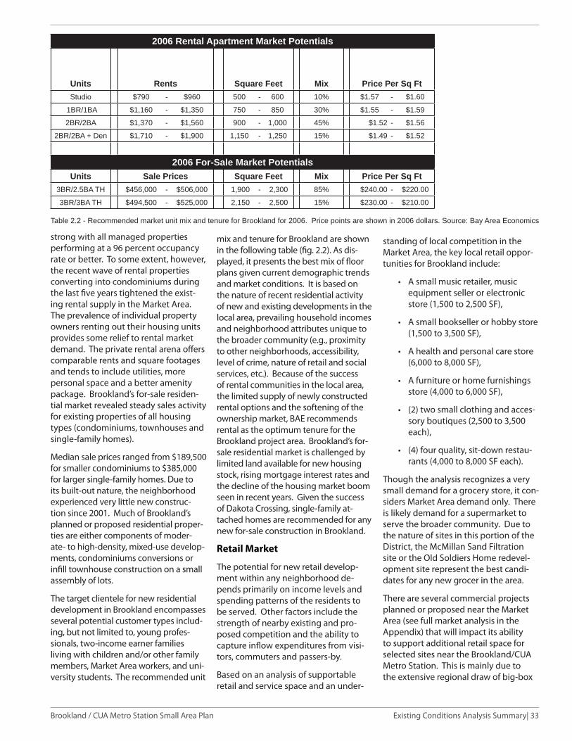
Existing Conditions Analysis Summary| 33Brookland / CUA Metro Station Small Area Plan
strong with all managed properties performing at a 96 percent occupancy rate or better. To some extent, however, the recent wave of rental properties converting into condominiums during the last fi ve years tightened the exist-ing rental supply in the Market Area. The prevalence of individual property owners renting out their housing units provides some relief to rental market demand. The private rental arena off ers comparable rents and square footages and tends to include utilities, more personal space and a better amenity package. Brookland’s for-sale residen-tial market revealed steady sales activity for existing properties of all housing types (condominiums, townhouses and single-family homes).
Median sale prices ranged from $189,500 for smaller condominiums to $385,000 for larger single-family homes. Due to its built-out nature, the neighborhood experienced very little new construc-tion since 2001. Much of Brookland’s planned or proposed residential proper-ties are either components of moder-ate- to high-density, mixed-use develop-ments, condominiums conversions or infi ll townhouse construction on a small assembly of lots.
The target clientele for new residential development in Brookland encompasses several potential customer types includ-ing, but not limited to, young profes-sionals, two-income earner families living with children and/or other family members, Market Area workers, and uni-versity students. The recommended unit
mix and tenure for Brookland are shown in the following table (fi g. 2.2). As dis-played, it presents the best mix of fl oor plans given current demographic trends and market conditions. It is based on the nature of recent residential activity of new and existing developments in the local area, prevailing household incomes and neighborhood attributes unique to the broader community (e.g., proximity to other neighborhoods, accessibility, level of crime, nature of retail and social services, etc.). Because of the success of rental communities in the local area, the limited supply of newly constructed rental options and the softening of the ownership market, BAE recommends rental as the optimum tenure for the Brookland project area. Brookland’s for-sale residential market is challenged by limited land available for new housing stock, rising mortgage interest rates and the decline of the housing market boom seen in recent years. Given the success of Dakota Crossing, single-family at-tached homes are recommended for any new for-sale construction in Brookland.
Retail Market
The potential for new retail develop-ment within any neighborhood de-pends primarily on income levels and spending patterns of the residents to be served. Other factors include the strength of nearby existing and pro-posed competition and the ability to capture infl ow expenditures from visi-tors, commuters and passers-by.
Based on an analysis of supportable retail and service space and an under-
Table 2.2 - Recommended market unit mix and tenure for Brookland for 2006. Price points are shown in 2006 dollars. Source: Bay Area Economics
standing of local competition in the Market Area, the key local retail oppor-tunities for Brookland include:
A small music retailer, music • equipment seller or electronic store (1,500 to 2,500 SF),
A small bookseller or hobby store • (1,500 to 3,500 SF),
A health and personal care store • (6,000 to 8,000 SF),
A furniture or home furnishings • store (4,000 to 6,000 SF),
(2) two small clothing and acces-• sory boutiques (2,500 to 3,500 each),
(4) four quality, sit-down restau-• rants (4,000 to 8,000 SF each).
Though the analysis recognizes a very small demand for a grocery store, it con-siders Market Area demand only. There is likely demand for a supermarket to serve the broader community. Due to the nature of sites in this portion of the District, the McMillan Sand Filtration site or the Old Soldiers Home redevel-opment site represent the best candi-dates for any new grocer in the area.
There are several commercial projects planned or proposed near the Market Area (see full market analysis in the Appendix) that will impact its ability to support additional retail space for selected sites near the Brookland/CUA Metro Station. This is mainly due to the extensive regional draw of big-box
2006 Rental Apartment Market Potentials
Units Rents Square Feet Mix Price Per Sq FtStudio $790 - $960 500 - 600 10% $1.57 - $1.60
1BR/1BA $1,160 - $1,350 750 - 850 30% $1.55 - $1.59
2BR/2BA $1,370 - $1,560 900 - 1,000 45% $1.52 - $1.56
2BR/2BA + Den $1,710 - $1,900 1,150 - 1,250 15% $1.49 - $1.52
2006 For-Sale Market PotentialsUnits Sale Prices Square Feet Mix Price Per Sq Ft
3BR/2.5BA TH $456,000 - $506,000 1,900 - 2,300 85% $240.00 - $220.00
3BR/3BA TH $494,500 - $525,000 2,150 - 2,500 15% $230.00 - $210.00

34| Existing Conditions Analysis Summary Brookland / CUA Metro Station Small Area Plan
retailers, the appeal of new stores and clustered retail to prospective shop-pers, and the competition of existing and future retailers in Prince George’s County. Capturing dollars spent by students living on CUA’s campus (a population limited by income and transportation) as well as faculty, staff and visitors will assist in the success of any new retail stock. Additional advan-tages for new retailers on selected sites are their visibility and accessibility to a main roadway and their ability to off er a selection of goods, services and/or unique entertainment options appeal-ing to residents, students and others affi liated with CUA. Current initiatives by the Brookland Community Develop-ment Corporation and reSTORE DC to improve the image and nature of 12th Street will increase the neighborhood’s appeal to potential new retailers.
Offi ce Market
As a mainly residential community with minimal offi ce (primarily Class B neigh-borhood-serving offi ce) and an absence of competitive features to attract new offi ce development, Brookland is not well positioned to attract Class A offi ce users. Large corporate offi ce tenants such as lawyers, engineers, and other consultants look for business park loca-tions and/or Class A offi ce buildings with prominent locations, excellent access to transit and transportation corridors, nearness to high-quality retail and supportive services, state-of-the-art building systems and high quality standard fi nishes. The majority of the Brookland’s offi ce tenant mix consists of supportive offi ce space for CUA and Trinity College, small non-profi t orga-nizations, neighborhood-related users (doctors, accountants, and insurance agents) and supportive offi ce space for light industrial and manufacturing ten-ants. These offi ce tenants depend on good access to their primary clientele, are often more price sensitive than larger corporations and tend to remain at these locations for long periods of time.
The strength of neighboring submar-kets in both the District and Prince George’s County as well as a small num-ber of available sites compromise the neighborhood’s ability to attract addi-
tional growth from corporate clientele. Sites such as the Old Soldier’s Home and McMillan Sand Filtration would likely capture more of the hospital-gen-erated and institutional offi ce demand. The low vacancy rate of Brookland’s offi ce market is more attributable to a small, obsolete offi ce supply than a stable offi ce market environment. The sustainability of Brookland’s existing offi ce market indicates consistent local demand for neighborhood-serving and university-related offi ce users and small nonprofi t organizations in need of more aff ordable offi ce space near their clientele.
The market could support modest of-fi ce growth of 20,000 to 30,000 square feet over the next 10 to 15 years with some of this space replacing existing structures. This space could exist as new offi ce condominiums that resemble townhouses. As the nature of the transit station shifts with new development, opportunities could exist to rehab exist-ing warehouse/fl ex space for area non-profi t organizations or other users.
Please refer to the document, Market Analysis for Brookland Station Area Plan Final Report, January 2007, for the com-plete Market Analysis.
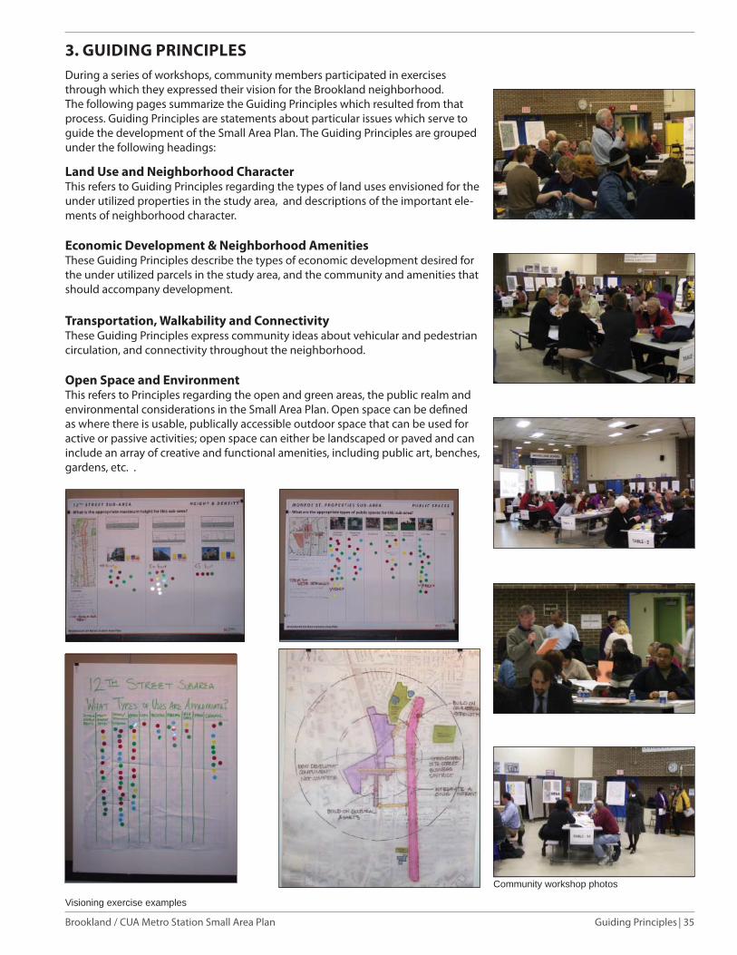
| 35Guiding PrinciplesBrookland / CUA Metro Station Small Area Plan
3. GUIDING PRINCIPLES During a series of workshops, community members participated in exercises through which they expressed their vision for the Brookland neighborhood. The following pages summarize the Guiding Principles which resulted from that process. Guiding Principles are statements about particular issues which serve to guide the development of the Small Area Plan. The Guiding Principles are grouped under the following headings:
Land Use and Neighborhood CharacterThis refers to Guiding Principles regarding the types of land uses envisioned for the under utilized properties in the study area, and descriptions of the important ele-ments of neighborhood character.
Economic Development & Neighborhood AmenitiesThese Guiding Principles describe the types of economic development desired for the under utilized parcels in the study area, and the community and amenities that should accompany development.
Transportation, Walkability and ConnectivityThese Guiding Principles express community ideas about vehicular and pedestrian circulation, and connectivity throughout the neighborhood.
Open Space and EnvironmentThis refers to Principles regarding the open and green areas, the public realm and environmental considerations in the Small Area Plan. Open space can be defi ned as where there is usable, publically accessible outdoor space that can be used for active or passive activities; open space can either be landscaped or paved and can include an array of creative and functional amenities, including public art, benches, gardens, etc. .
Community workshop photos
Visioning exercise examples

36| Guiding Principles Brookland / CUA Metro Station Small Area Plan
Economic Development & Neighborhood Amenities
Guiding Principles
Strengthen and support the 12th Street historic area and commercial core;•
Add new retail and businesses to compliment 12th Street and provide needed • services;
Acquire services from and provide jobs for local residents;•
Create an enhanced civic infrastructure and support local schools;•
Create opportunities for cultural events and public art;•
Enhance the public realm by addressing safety and cleanliness issues.•
Work with residents and stakeholders to create a list of preferred community • benefi ts that can be addressed as planned unit developments are generated.
Fig. 3.2 – Economic Development & Neighborhood Amenities concept diagram
Land Use and Neighborhood Character Guiding Principles
Protect existing neighborhood character;•
Highlight neighborhood historic and cultural resources;•
Create an active pedestrian neighborhood with mixed-use development and a • variety of housing types for all income levels;
Provide civic and cultural amenities;•
Promote quality in design of buildings and public spaces.•
Fig. 3.1 – Land Use and Neighborhood Character concept diagram
Active pedestrian neighborhood examples
Neighborhood retail examples

| 37Guiding PrinciplesBrookland / CUA Metro Station Small Area Plan
Open Space and Environment Guiding Principles
Improve and maintain existing park spaces; •
Increase Open Space throughout the neighborhood;•
Improve and maintain street trees and plantings; •
Employ sustainable building and site design strategies; •
Employ on-site green storm water management strategies.•
Identify locations for additional pocket parks•
Fig. 4.4 – Open Space and Environment concept diagram
Transportation, Walkability and Connectivity Guiding Principles
Address traffi c impacts and protect neighborhood from additional traffi c;•
Promote and integrate bus, shuttles, bikes, rail and other transit options; •
Provide adequate parking while in keeping with Transit Oriented Development • principles;
Improve east-west connectivity across the neighborhood; •
Improve walkability around the neighborhood and connectivity to Metro and • 12th Street;
Enhance the public realm through improved streetscape, way fi nding, lighting, • landscaping and burying of utilities.Fig. 3.3 – Transportation, Walkability and
Connectivity concept diagram
Fig. 3.4 – Open Space and Environment concept diagram

38| Small Area Plan Brookland / CUA Metro Station Small Area Plan
4. SMALL AREA PLAN
Urban Design Concepts
The Brookland/CUA Metro Station Small Area Plan guides the growth and development of the neighborhood. The following are the urban design concept elements of the plan.
Land Use and Neighborhood
Character
The Small Area Plan proposes new moderate density mixed use develop-ment in key subareas, including the Metro Station and Monroe Street. New development should create active pedestrian friendly neighborhoods and provide a variety of housing types for all income levels.
To achieve these land use and zoning changes, property owners or develop-ers will be required to apply for discre-tionary approval of Planned Unit Devel-opments or a zoning map amendment.
An owner can proposed changes to the current zoning of a property through a map amendment process. A map amendment application is reviewed by the District’s Zoning Commission; pub-lic review and comment is an essential part of this process.
A planned unit development (PUD) may also be proposed by a property owner or developer. A PUD is a project-specifi c zoning case, heard and decided by the Zoning Commission. The PUD process is designed to encourage high quality developments that provide public ben-efi ts. The overall goal is to permit fl ex-ibility of development and other incen-tives, such as increased building height and density provided that the project off ers a commendable public benefi ts such as public space improvements and aff ordable housing. PUD limits for height and density have already been established in the zoning regulations. The PUD is a discretionary process that includes public review and comment. PUD’s may also include a related map amendment application.
The Metro Station is envisioned to be-come a mixed-use, transit-oriented and civic core for the community, with the Fig.4.1 – Concept diagram
Note 3 (See Appendix)*

| 39Small Area PlanBrookland / CUA Metro Station Small Area Plant
arts as a key element.
A new civic plaza and open space is proposed at the Metro Station along an extended Newton Street, integrated with Brooks Mansion. It is the place for community gathering and interaction, cultural and arts activities, and for the Farmers Market. Residential units above retail overlook the plaza.
The plan envisions the relocation of the two Metro Station entrances slightly south to align with Newton Street. These portals act as Metro gateways to Brookland bringing residents and visi-tors to activate the plaza and to support the new development at the station, Monroe Street, and on 12th Street. The openness along Newton Street at the Station will maintain views toward the Shrine from the east.
Brooks Mansion, and the open space around it, are envisioned to become an important green civic element for the community in the future. It could serve as a community building such as a com-munity center or library, while its grounds could become a park or Open Space.
Monroe Street is the primary gateway and connector between the East and West sides of Brookland. A Open Space and plaza are proposed for Monroe Street at its intersection with Michigan Avenue, creating a western gateway to the neighborhood. Monroe Street is envisioned as a tree-lined mixed-use street, with neighborhood-serving retail, restaurants, arts and cultural uses on the ground fl oor, and residential above.
Components of Catholic University’s arts programs, as well as neighbor-hood organizations such as Dance Place could become cultural features of Monroe Street, potentially establishing a Brookland Arts District.
12th Street is the strengthened Main Street of Brookland and the focus of mixed-use infi ll development. Imple-mentation of proposed streetscape im-provements, additional infi ll mixed-use development, and improved connectiv-ity with Monroe Street and the Metro station will enhance businesses and the civic life of 12th Street.
Throughout the planning process, some
members of the community voiced strong concerns regarding the unique view sheds to the Shrine of the Im-maculate Conception and the transition from new higher density development to existing lower scale residential areas. In response to the these concerns, the plan includes an number of urban de-sign techniques, such as building height setbacks and steps down, as detailed in the subarea plans. Another solution to be considered through the Planned Unit Development process, is shifting height from one location to another, where lower height would preserve unique view corridors and/or provide a better transition to lower scale residen-tial areas. This would be considered in cases where the total building height in the new location does not exceed 15% of the maximum height allowed in that subarea.
Additional density may be proposed through the PUD for key sub-areas when it is necessary for the fulfi llment of the objectives of the plan.
Economic Development and Neighborhood Amenities
The Small Area Plan proposes new mixed-use and residential development to bring people to the neighborhood, and to provide needed neighborhood retail, amenities and services.
The Metro Station area will include resi-dential units above neighborhood-serv-ing retail together with public spaces for community gathering and interac-tion. Monroe Street will be lined with a mix of uses, including retail, restaurants, arts and cultural uses on the ground fl oor, and residential above stores west of the tracks, infi ll and redevelopment east of the tracks to 12th Street. 12th Street will be the focus of mixed-use infi ll development.
The commercial areas north and south of the Metro station, are proposed to be new residential and small commercial areas. The commercial area north of the station is envisioned to be formed along new streets and blocks that ex-tend the existing fabric of the neighbor-hood. Residential units, consisting of townhouses and apartments or condo-miniums would be compatible with the
Fig. 4.2 – Small Area Plan Illustrative drawing
existing neighborhood, tapering down in height toward existing residential. The commercial area south of the Metro Station is envisioned as additional resi-dential development, compatible with the neighboring residential area.
Transportation, Connectivity, Walkability
The Small Area Plan proposes strate-gies to create better and more effi cient pedestrian and vehicular connectivity and linkages to neighborhood desti-nations. Reestablishing the fabric and grid of streets and blocks wherever possible will reconnect the neighbor-hood by allowing for better, circulation around the neighborhood and better pedestrian connectivity.
Street extensions and realignments include:
The extension of 9th Street north • under Michigan Avenue and Newton Street west into the Metro Station;
The extension of Perry Street west • into the commercial area north of the Metro Station to create a new fabric of streets and blocks for that area;
The extensions of Kearny and • Lawrence Streets west to create new blocks south of Monroe Street;
The extension of 8th Street north of •

40| Small Area Plan Brookland / CUA Metro Station Small Area Plan
associated with under grounding the utility lines has posed challenges to implementation. This plan recommends that pursuing this through new development and as a potential community benefi t from proposed planned unit develop-ments.
As discussed in the Existing Conditions section, recommendations for traffi c, transit, parking, bi-cycle and pedestrian improvements are included in the Recommendations and Implementation section of the Plan. These recommendations are designed to realize the guiding principles discussed earlier in this document. More impor-tantly, the recommendations seek to strengthen the multi-modal opportunities so that residents, visitors, and workers can enjoy expanded trans-portation choices.
Develop a strategy for shared parking and • implementation of car sharing programs in all new developments
Open Space and Environment
New public spaces, open spaces, and civic plazas are envisioned for the Metro Station area and along Monroe Street. Specifi c areas include Monroe Street, west of 7th Street; along Newton Street between 9th and 10th Streets; at Brooks Mansion, with a future active community Open Space to include the current parking lot; and in the Commercial North sub-area, a new park cen-tral to the new residential development.
Several development opportunity sites within the Metro station and Monroe Street subareas are currently vacant. This unimproved land is privately held and does not function as an ac-cessible public open space.
Sidewalks should include Open Space potential-ly in the form of continuous tree and planting areas. Improved streetscape should including paving, lighting and trees will be implemented with all new development. Open Spaces and new street trees, made possible by the under grounding of utilities, are envisioned to be part of every new development.
New development will be subject to the require-ments of the DC Green Building Act of 2006. In concert with this, buildings shall be energy effi cient. Green strategies for on-site storm water management should be implemented with each new development and any new buildings, public spaces, roadways and infrastructure. These could include vegetated roofs, porous paving, and vegetated curb extension swales for the on-site collection, storage and fi ltering of storm water runoff .
Fig. 4.3 – Concept diagram
Green BuildingGreen building is an approach to buildings design, construction and operations that conserves resources while it protects human health. Green buildings use less energy, consume fewer natural resources such as water and forest products, and emit fewer pollutants into the environment. Because they are designed to make use of natural light and good ventilation, green buildings provide a healthier indoor environment for their occupants. Studies show that students in green buildings learn better and workers in green buildings are more productive.
Green building is an integral part of the District’s sustainable development strategy. The Green Building Act of 2006 requires that all District public buildings meet the US Green Building Council’s LEED certifi cation standards for environmental performance. The District supports private sector innovation by expediting LEED Gold-level projects through the permitting process. By 2012, all new private development projects will be required to meet LEED certifi cation.
Sustainable Development Resources:
Guide to Green BuildingsContains principles, practices and resources that help make sustainable, green development part of our everyday practices for both new construction and renovations.
U.S. Green Building CouncilOversees the Leadership in Energy and Environmental Design (LEED) Green Building Rating System affecting all types of green buildings, including commercial, schools and homes.
Green Building Act of 2006Establishes high-performance building standards that require the planning, design, construction, operation and maintenance of building projects, and a green buildings incentive program.
Monroe Street;
The connection of 8th Street • with John McCormack Road at Michigan Avenue;
The realignment of 7th Street • with the entrance to Catho-lic University at Michigan Avenue;
The realignment of the inter-• section of Monroe Street with Michigan Avenue;
The Small Area Plan also propos-
es improved east-west connectiv-ity across the neighborhood pri-marily along a revitalized Monroe Street. It includes the integration of the Metropolitan Branch Trail on the west of side of the CSX/Metro tracks along 8th Street and John McCormack Road.
Throughout the community plan-ning process, residents raised concerns regarding the overhead power lines that are visually unappealing and interfere with street tree growth. The high cost

| 41Small Area PlanBrookland / CUA Metro Station Small Area Plant
Fig. 4.4 – Small Area Plan illustrative drawing
Small Area Plan Urban Design Concepts Summary
Land Use and Neighborhood Character
Mixed-use transit-oriented community • civic core with arts elements;Community civic plaza and Open • Space at Metro station and Newton Street; Note 2 (See Appendix)Relocated Metro entrances to activate • plaza;Views to the National Shrine;• Brooks Mansion as future civic build-• ing, and its Open Space integrated with civic plaza;Monroe Street as primary east-west • connector with mixed-use develop-ment;12th Street as revitalized and strength-• ened main street for Brookland.
Economic Development
and Neighborhood Amenities
Mixed-use transit-oriented • develop-ment.Strengthened 12th Street core;• Redeveloped Metro station with a mix • of uses;Mixed-use redevelopment along • Monroe street from Michigan Avenue to 12th Street;Infi ll and redevelopment opportuni-• ties along 12th Street;Residential uses north and south of • Metro Station.
Transportation, Walkability
and Connectivity
Restoration of street fabric through ex-• tensions and realignments of streets;Monroe Street as strengthened east-• west connector;Gateways and arrival points along • Monroe Street at Michigan Avenue and 12th Street;Integration of Metropolitan Branch • Trail west of the tracks.
Open Space and Environment
New plaza and open space at Metro • station along Newton Street. Brooks Mansion as civic building and • open space;New open spaces integrated into • new development;Use of green building techniques • and site design.

42| Small Area Plan Brookland / CUA Metro Station Small Area Plan
This page intentially left blank

43| Sub Areas Brookland / CUA Metro Station Small Area Plan
5. SUB-AREA PLANS
The assessment of the existing neigh-borhood fabric and condition suggest-ed the identifi cation of fi ve sub-areas for study in greater detail. These sub-areas include the station itself, Monroe Street between Michigan Avenue and 12th Street, 12th Street itself, and the commercial areas north and south of the Metro Station along the tracks.
Fig. 5.1 – Sub-areas key planCommercial Area - South
Commercial Area - North
12th Street NE
Monroe Street
Brookland/CUA Metro Station
Commercial Area - North sub-area
Commercial Area - South sub-area
Metro Station sub-area
Monroe Street sub-area
12th Street sub-area
Note 6 (See Appendix)*

| 44Sub AreasBrookland / CUA Metro Station Small Area Plan
Fig. 5.3 – Illustrative Plan of Metro Station sub-area
Metro Station Sub-Area
Vision:
Metro Station as a new mixed-use transit-oriented civic core for Brookland.
Framework Plan:
Reestablished street fabric through • extensions, realignments, and recon-nections of streets;
Mixed-use development including • community-serving retail and resi-dential surrounding public spaces;
Metro Station entries relocated to • align with Newton Street and inte-grated with public spaces;
Public spaces for civic and cultural • activities, community gathering and the Farmers Market at Metro portal, Newton Street integrated with Brooks Mansion and at the Metro portals;
Busses, shuttles, kiss ‘n ride and • short-term parking integrated with street grid.
Fig. 5.2 Metro Station sub-area existing conditions plan
Monroe Street
Michiga
n Ave
.
Otis Street
Newton Street
9th Street
10th Street
Fig. 5.4 Illustrative section 1
11
R-5-A
R-2

45| Sub Areas Brookland / CUA Metro Station Small Area Plan
Recommendations:
Develop a moderate-density mix 1. of uses including retail, offi ce, residential and cultural uses at the Metro Station.
Provide adequate parking but at 2. low transit-oriented development parking ratios.
Extend 9th Street, Otis Street and 3. Newton Street into the Metro Sta-tion area.
Defi ne Otis and Newton Streets 4. between 12th Street and the Metro Station as a walkable and inviting connection between the station and the commercial area.
Use streetscape enhancements and 5. signage to create more identifi -able and inviting pedestrian (and vehicular) connections from the 12th Street commercial corridor to the Brookland/CUA Metro Station along Newton and Otis Streets.
Place bus routes on the street grid 6. with bus stops along 9th Street.
Place Kiss ’n ride, short-term park-7. ing along 9th and Newton Streets.
Work with the Offi ce of Property 8. Management on the design and accessibility of the open space surrounding the Brooks Mansion creating a community civic and open space along Newton Street, integrated with Brooks Mansion and it’s grounds.
Develop a shuttle consolidation 9.
strategy to implement a more ef-fi cient shuttle pick-up and drop-off system.
Create a community civic and Open 10. Space along Newton Street, inte-grated with Brooks Mansion and its grounds.
Relocate the Metro Station portals 11. to align with Newton Street.
Develop low-density residential 12. along the west side of 10th Street between Otis Street and Newton Street; alternatively utilize this area as an expanded open space to tran-sition to the lower scale residential area east of 10th Street. Diagrams illustrating this option are included in the Appendix A Concept Alterna-tives, fi gure A.3.
Work with residents, local busi-13. ness, cultural and civic associations to program activities, such as the weekly Farmers Market, and arts/cultural exhibits and performances at neighborhood public spaces.
Development up to 6 stories or a 14. maximum 70 feet may be allowed through a Planned Unit Develop-ment, a discretionary approval by the District’s Zoning Commission.
WMATA will resume its transporta-15. tion access study for the Brookland Metro station to fully assess the recommendations in the draft plan and their impact on transit service delivery. WMATA representa-
Fig. 5.5 – Metro Station sub-area concept diagram
Metro Portal
Mixed-use development
Fig. 5.6 – Metro Station sub-area framework plan
tives participated in the planning process and served on the advisory committee. The Offi ce of Planning anticipates that the coordination and engagement between WMATA, the District, and the community will continue when the access study resumes.
Building facades facing a public 16. street in the sub area should step back in height at a ratio of one half (1/2) to one above 50 feet.
Building facades along Newton 17. Street and the Metro Plaza should step back in height at a ratio of one to one above 50 feet in order to preserve views to the Basilica of the National Shrine of the Immaculate Conception.
Development Opportunity: Residential 200-250 units • 30-35K Retail/Restaurant/Cultural• 220-265 parking spaces (l-2 levels • below grade)
Note: Proposed zoning changes or planned unit developments that are consistent with this small area plan are discretionary and require separate approval by the District’s Zoning Commission. Each application requires public notifi cation, as well as review by the aff ected Advisory Neighborhood Commission. Note 3 (See Appendix)
Note 2 (See Appendix)*
Note 3 (See Appendix)*
Note 5 (See Appendix)*

| 46Sub AreasBrookland / CUA Metro Station Small Area Plan
Fig. 5.7 – Illustrative plan of Monroe Street sub-area
Fig. 5.11 - Illustrative section 4Fig. 5.10 - Illustrative section 3Fig. 5.9 - Illustrative section 2
Monroe Street Sub-Area
Vision:
Monroe as a revitalized, tree-lined ur-ban street, connecting Brookland from west to east with retail, residential and cultural and arts uses.
Framework Plan:
Reestablished street fabric through • extensions, realignments, and recon-nections of streets.
Mixed-use development with • community-serving retail, residen-tial, cultural uses and public spaces along Monroe Street from Michigan Avenue to 12th Street to connect Brookland from west to east.
A gateway to Brookland at Monroe • Street and Michigan Avenue, and an arrival point at Monroe Street and 12th Streets.
Civic and Open Spaces along Monroe • Street west of tracks and at Brooks Mansion.
Recommendations:
Realign Monroe Street with Michi-1. gan Avenue at western end.
Realign 7th Street north of Monroe 2. Street at Michigan Avenue with entrance to Catholic University.
Extend 8th Street north of Monroe 3. Street to align with John McCor-mack Road at Michigan Avenue.
Fig. 5.8 Monroe Street sub-area existing conditions plan
2
34
R-2
R-4

47| Sub Areas Brookland / CUA Metro Station Small Area Plan
Connectivity can take many forms. The conceptual plan shows an extended 8th Street that connects Monroe and Michigan Avenue; an extended 8th Street could accom-modate vehicles or be limited to pedestrians. The connection could also be made via the Metropolitan Branch Trail.
Develop a moderate-density mix 4. of uses along Monroe Street west of the WMATA/CSX tracks with com-munity-serving retail, residential, cultural uses and public spaces.
Provide adequate parking but at 5. low transit-oriented development parking ratios.
Development along Monroe Street 6. west of the WMATA/CSX tracks may be allowed up to 6 stories or a max-imum 70 feet through a Planned Unit Development, a discretionary approval by the District’s Zoning Commission. Building heights should taper down to transition to adjacent lower scale residential structures.
Allow infi ll and redevelopment 7. along Monroe Street east of the WMATA/CSX tracks.
Development along Monroe Street 8. east of the WMATA/CSX tracks may be allowed up a maximum 50 feet through a Planned Unit Develop-ment, a discretionary approval by the District’s Zoning Commission.
Development should provide visual 9. and noise buff ers from train tracks and neighboring production, distri-bution, and repair (PDR) uses.
Buildings in the subarea should 10. step back in height at a ratio of one half (1/2) to one (1) above 50 feet. For example, for every 10 feet in height above 50 feet, the building facade should step bqck 5 feet from the building edge.
Coordinate a retail strategy to 11. encourage complimentary retail and businesses for both 12th and Monroe Streets.
Create a large civic/open space as 12. part of new development along
Monroe Street west of the WMATA/CSX tracks.
Reposition Brooks Mansion as a 13. community civic building and its grounds as a civic open space. Consider removing the surface parking area to reclaim additional Open Space and integrate with the Newton Street public space.
Development Opportunity:
Residential 750-900 units; • 80-100K Retail/Restaurant/Cultural;• 650-850 parking spaces (l-2 levels • below grade).
Note: Proposed zoning changes or planned unit developments that are consistent with this small area plan are discretionary and require separate approval by the District’s Zoning Commission. Each application requires public notifi cation, as well as review by the aff ected Advisory Neighborhood Commission.
Fig. 5.13 – Monroe Street sub-area Framework plan
Fig. 5.12 – Concept diagram of Monroe Street sub-area
Places for gathering and interaction
Public spaces
Places for performances and public art
Note 3 (See Appendix)*

| 48Sub AreasBrookland / CUA Metro Station Small Area Plan
Fig. 5.15 - Illustrative section 5Fig. 5.16 – Illustrative plan of 12th Street sub-area north of Monroe St.
Fig. 5.17 – Illustrative plan of 12th Street sub-area south of Monroe St.
12th Street Sub-Area
Vision:
12th Street as Brookland’s revitalized and strengthened Historic Main Street.
Framework Plan:
• Improved connectivity to western part of Brookland and Metro station along Newton and Monroe Streets;
• New streetscape, landscape, lighting, and storefront improvements;
• Infi ll, redevelopment and revitaliza-tion opportunities for retail, offi ce, and residential.
Recommendations:
1. Develop mix of uses including retail, offi ce, residential and cultural uses as redevelopment and infi ll development along 12th Street.
2. Enliven the intersection at 12th and Monroe Street. Create an authentic community gathering spot that blends the main street feel from 12th street, surrounding residential and institution-al uses on Monroe Street. Consider uses that compliment existing retail.
Fig. 5.14 - 12th Street sub-area existing Conditions plan
12th Street