bushfire attack level assessment
TRANSCRIPT

BAL Assessment and Management Statement: Lot 12 Jarrahdale Road, Jarrahdale
1
AS3959 Bushfire Attack Level
Assessment Report
This report has been prepared using the Simplified Procedure (Method 1) as detailed in Section 2 of AS3959-2018.
Site Details
Address: Lot 12 Jarrahdale Road
Suburb: Jarrahdale
Local Government Area Shire of Serpentine Jarrahdale
State: Western Australia
Description of Building Works Single Class 1 Dwelling
Report Details
Report / Job Number: 2006-99 Report Version 1.0
Assessment Date: 11/5/2020 Report Date 13/6/2020
Assessor Details
Name: Rohan Carboon
Accredited Practitioner Rohan Carboon BPAD 23160
Disclaimer:
This report has been prepared in good faith and is derived from sources believed to be reliable and accurate at the time of publication. Nevertheless, this publication is distributed on the terms and understanding that the author is not responsible for results of any actions taken based on information in this publication or for any error in or omission from this publication.
Not withstanding the precautions adopted in this report, it should always be remembered that bushfires burn under a wide range of conditions. An element of risk, no matter how small always remains. The objective of the standard (AS 3959:2018) is ‘to prescribe particular construction details for buildings to reduce the risk of ignition from a bushfire while the front passes’ (Standards Australia, 2018). Building to the standard (AS 3959:2018) does not guarantee a building will survive a bushfire.
10.1.2 - Attachment 3
Ordinary Council Meeting - 11 October 2021

BAL Assessment and Management Statement: Lot 12 Jarrahdale Road, Jarrahdale
2
Site Assessment and Site Plans
The assessment of this development was undertaken on 15/04/2020 by Bushfire Safety Consulting Pty Ltd for the purposes of determining the Bushfire Attack Level in accordance with AS 3959 – 2018 Simplified Procedure (Method 1).
10.1.2 - Attachment 3
Ordinary Council Meeting - 11 October 2021

BAL Assessment and Management Statement: Lot 12 Jarrahdale Road, Jarrahdale
3
Vegetation Classification
All vegetation within 150m of the proposed dwelling was classified in accordance with Clause 2.2.3 of AS 3959-2018. Each distinguishable vegetation plot with the potential to determine the Bushfire Attack Level is identified below:
Photo ID: 1
Plot Number: 1
Vegetation classification or exclusion clause:
Class A Forest
Description/justification of classification:
Marri and Jarrah forest with minimal middlestorey, but accumulated litter fuels
Photo ID: 2
Plot Number:1
Vegetation classification or exclusion clause:
Class A Forest
Description/justification of classification:
Marri and Jarrah forest with intact middlestorey and understorey
Photo ID: 3
Plot Number: 2
Vegetation classification or exclusion clause:
Class A Forest
Description/justification of classification:
Marri and Jarrah forest with intact middlestorey and understorey
Photo ID: 4
Plot Number: 2
Vegetation classification or exclusion clause:
Class A Forest
Description/justification of classification:
Marri and Jarrah forest with intact understorey and accumulated leaf litter.
Photo ID: 5
Plot Number: 2
Vegetation classification or exclusion clause:
Class A Forest
Description/justification of classification:
Marri and Jarrah forest with intact understorey and accumulated leaf litter.
10.1.2 - Attachment 3
Ordinary Council Meeting - 11 October 2021

BAL Assessment and Management Statement: Lot 12 Jarrahdale Road, Jarrahdale
4
Photo ID: 6
Plot Number: 3
Vegetation classification or exclusion clause:
Class B Woodland
Description/justification of classification:
Marri and Jarrah forest with intact middlestorey and understorey
Photo ID: 7
Plot Number: 4
Vegetation classification or exclusion clause:
Class B Woodland
Description/justification of classification:
Open canopy of Marri and Jarrah forest no middlestorey but leaf litter fuels
Photo ID: 8
Plot Number: 4
Vegetation classification or exclusion clause:
Class B Woodland
Description/justification of classification:
Open canopy of Marri and Jarrah forest no middlestorey but leaf litter fuels
Photo ID: 9
Plot Number: 5
Vegetation classification or exclusion clause:
Class C Shrubland
Description/justification of classification:
Low shrubland south of the dwelling with grasses
Photo ID: 10
Plot Number: 5
Vegetation classification or exclusion clause:
Class C Shrubland
Description/justification of classification:
Low shrubland south of the dwelling with grasses
10.1.2 - Attachment 3
Ordinary Council Meeting - 11 October 2021

BAL Assessment and Management Statement: Lot 12 Jarrahdale Road, Jarrahdale
5
Photo ID: 11
Plot Number: 6
Vegetation classification or exclusion clause:
Glass G Grassland
Description/justification of classification:
Very low grass fuels downslope of the dwelling
Photo ID: 12
Plot Number: 7
Vegetation classification or exclusion clause:
Glass G Grassland
Description/justification of classification:
Very low grass fuels upslope of the dwelling
Photo ID: 13
Plot Number: 5
Vegetation classification or exclusion clause:
Exclusion Clause 23.2.3.2e
Description/justification of classification:
Dam filled with water
Relevant Fire Danger Index
The fire danger index for this site has been determined in accordance with Table 2.1 in AS3959–2018.
Fire Danger Index: Table
FDI : 80 2.4.3
10.1.2 - Attachment 3
Ordinary Council Meeting - 11 October 2021

BAL Assessment and Management Statement: Lot 12 Jarrahdale Road, Jarrahdale
6
Potential Bushfire Impacts
The potential bushfire impact to the dwelling from the assessment is outlined below (Table 1).
Table 1: BAL Analysis
Plot Vegetation Classification Effective Slope Separation (m) BAL
1
Class A Forest
Downslope 9
39.2 BAL-29
Class A Forest
With compliant APZ as outlined in Management Statement 46 BAL-19
2 Class A Forest Flat / upslope 66 BAL-21.5
3 Class B Woodland Flat / upslope 57.1 BAL-12.5
4 Class B Woodland Downslope 9 42 BAL-19
5 Class c Shrubland Downslope 11° 46 BAL-12.5
6 Class G Grassland Downslope 6 0 BAL-FZ
7 Class G Grassland upslope 0 BAL-FZ
Determined Bushfire Attack Level
The determined Bushfire Attack Level (highest BAL) for the proposed dwelling has been determined in accordance with clause 2.2.6 of AS3959-2018 using the above analysis.
Determined Bushfire Attack Level in existing condition: BAL-FZ
Determined Bushfire Attack Level with compliant APZ as identified in Bushfire Management Statement
BAL-19
10.1.2 - Attachment 3
Ordinary Council Meeting - 11 October 2021

BAL Assessment and Management Statement: Lot 12 Jarrahdale Road, Jarrahdale
7
Appendix 1: Site Plan
10.1.2 - Attachment 3
Ordinary Council Meeting - 11 October 2021

BAL Assessment and Management Statement: Lot 12 Jarrahdale Road, Jarrahdale
8
Appendix 2: Additional Information / Advisory Notes
A Bushfire Attack Level (BAL) Assessment is a means of measuring the severity of a buildings potential exposure to ember attack, radiant heat and direct flame contact from a bushfire event, and thereby determining the construction measures required for the dwelling.
The method used to determination of the BAL rating, and subsequent building construction standards, are directly referenced from Australian Standard AS3959-2009 Construction of buildings in bushfire prone areas.
The BAL rating is determined through the identification and assessment of the following parameters:
• Fire danger Index (FDI) rating; assumed to be FDI-80 for Western Australia
• All classified vegetation within 100m of the subject building
• Separation distance between the building and the classified vegetation
• Slope of the land under the classified vegetation
AS3959-2009 has six (6) levels of BAL, based on the radiant heat flux exposure to the building, and also identifies the relevant sections for building construction as detailed below;
Bushfire Attack Level (BAL)
Classified Vegetation within 100m of the site and heat flux
exposure thresholds
Description of predicted bushfire attack and levels of exposure
Construction Sections (within
AS3959)
BAL-LOW See Clause 2.2.3.2 There is insufficient risk to warrant specific construction requirements
4
BAL-12.5 ≤12.5kW/m² Ember attack 3 & 5
BAL-19 >12.5kW/m² to ≤19kW/m² Increasing levels of ember attack and burning debris ignited by windbourne embers together with increasing heat flux
3 & 6
BAL-29 >19kW/m² to ≤29kW/m² Increasing levels of ember attack and burning debris ignited by windbourne embers together with increasing heat flux
3 & 7
BAL-40 >29kW/m² to ≤40kW/m² Increasing levels of ember attack and burning debris ignited by windbourne embers together with increasing heat flux with the increased likelihood of exposure to flames
3 & 8
BAL-FZ >40kW/m² Direct exposure to flames from fire front in addition to heat flux and ember attack
3 & 9
10.1.2 - Attachment 3
Ordinary Council Meeting - 11 October 2021
Bushfire Management Statement prepared in accordance with the Guidelines for Planning in Bushfire Prone Areas V1.3 (December 2017)
PROPERTY:
DWELLING:
LAND OWNER:
BUSHFIRE CONSULTANT:
SIGNATURE:
DATE:This Bushfire Management Statement forms part of the terms of the planning approval as stamped and outlines the land owners ongoing land management responsibilities to minimise bushfire risk and ensure compliance with the WA Planning for Bushfire Protection Guidelines and the Shire's Annual Firebreak and Fuel Load Notice
PO BOX 84 STONEVILLE WA 6081
Mbl: 0429 949 262www.bushfiresafety.net
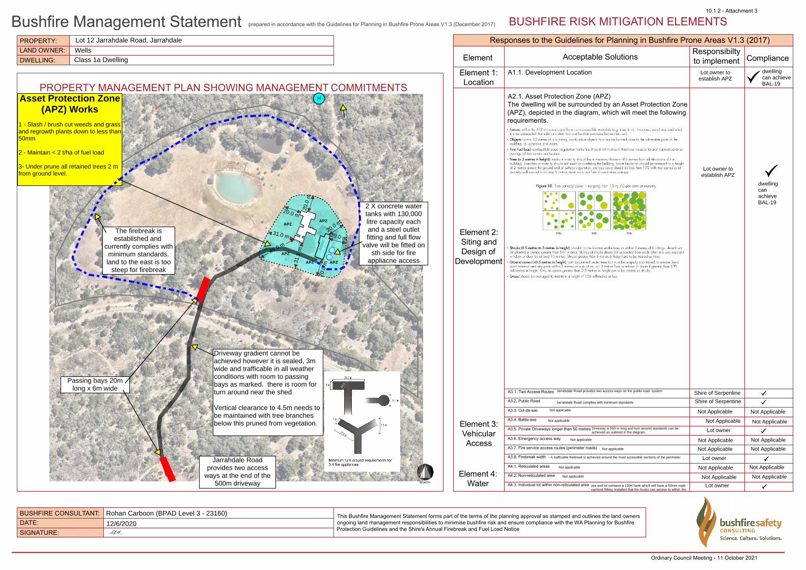
BUSHFIRE RISK MITIGATION ELEMENTS
PROPERTY MANAGEMENT PLAN SHOWING MANAGEMENT COMMITMENTS
Responses to the Guidelines for Planning in Bushfire Prone Areas V1.3 (2017)
Element Acceptable SolutionsResponsibiltyto implement Compliance
Element 1:Location
A1.1. Development Location
A2.1. Asset Protection Zone (APZ)The dwelling will be surrounded by an Asset Protection Zone (APZ), depicted in the diagram, which will meet the following requirements.
Element 2:Siting andDesign of
Development
Element 3:VehicularAccess
Element 4:Water
A3.1. Two Access Routes
A3.2. Public Road
A3.3. Cul-de-sac
A3.4. Battle-axe
A3.5. Private Driveways longer than 50 metres
A3.6. Emergency access way
A3.7. Fire service access routes (perimeter roads)
A3.8. Firebreak width
A4.1. Reticulated areas
A4.2. Non-reticulated area
A4.3. Individual lot within non-reticulated areaNORTH
Lot 12 Jarrahdale Road, Jarrahdale
WellsClass 1a Dwelling
Lot owner toestablish APZ
Lot owner toestablish APZ
The firebreak isestablished and
currently complies withminimum standards.land to the east is too
steep for firebreak
Rohan Carboon (BPAD Level 3 - 23160)
12/6/2020
Asset Protection Zone(APZ) Works
1 - Slash / brush cut weeds and grassand regrowth plants down to less than50mm
2 - Maintain < 2 t/ha of fuel load 3- Under prune all retained trees 2 mfrom ground level.
Jarrahdale Road provides two access ways on the public road system Shire of Serpentine
Jarrahdale Road complies with minimum standards
Not applicable Not Applicable
Not Applicable Not Applicable
Not Applicable Not Applicable
Lot owner
Not Applicable Not Applicable
- A trafficable firebreak is achieved around the most accessible sections of the perimeter
dwelling can achieve BAL-19
dwellingcanachieve BAL-19
Driveway is 500 m long and turn around standards can be achieved as outlined in the diagram.
Not Applicable
Not applicable
Not applicable
Not applicable
Lot owner
yes and lot contains a 130Kl tank which will have a 50mm malecamlock fitting installed that fire trucks can access to within 3m.
Passing bays 20mlong x 6m wide
H
Jarrahdale Roadprovides two access
ways at the end of the500m driveway
Driveway gradient cannot beachieved however it is sealed, 3mwide and trafficable in all weatherconditions with room to passingbays as marked. there is room forturn around near the shed
Vertical clearance to 4.5m needs tobe maintained with tree branchesbelow this pruned from vegetation.
130,000 litre colorbondtank with 2 inch male
camlock fitting
Lot owner
20.0 m
31.1
m46.0 m
20.0
m
20.0 m
20.0
m
20.0 m
31.0 m
APZAPZ
APZ APZ
APZ
2 X concrete watertanks with 130,000litre capacity eachand a steel outletfitting and full flow
valve will be fitted onsth side for fire
appliacne access
Not applicable
Shire of Serpentine
Not Applicable Not Applicable
Not applicable Not Applicable Not Applicable
10.1.2 - Attachment 3
Ordinary Council Meeting - 11 October 2021