bushfire management statement 6 railway line road, kawarren
TRANSCRIPT
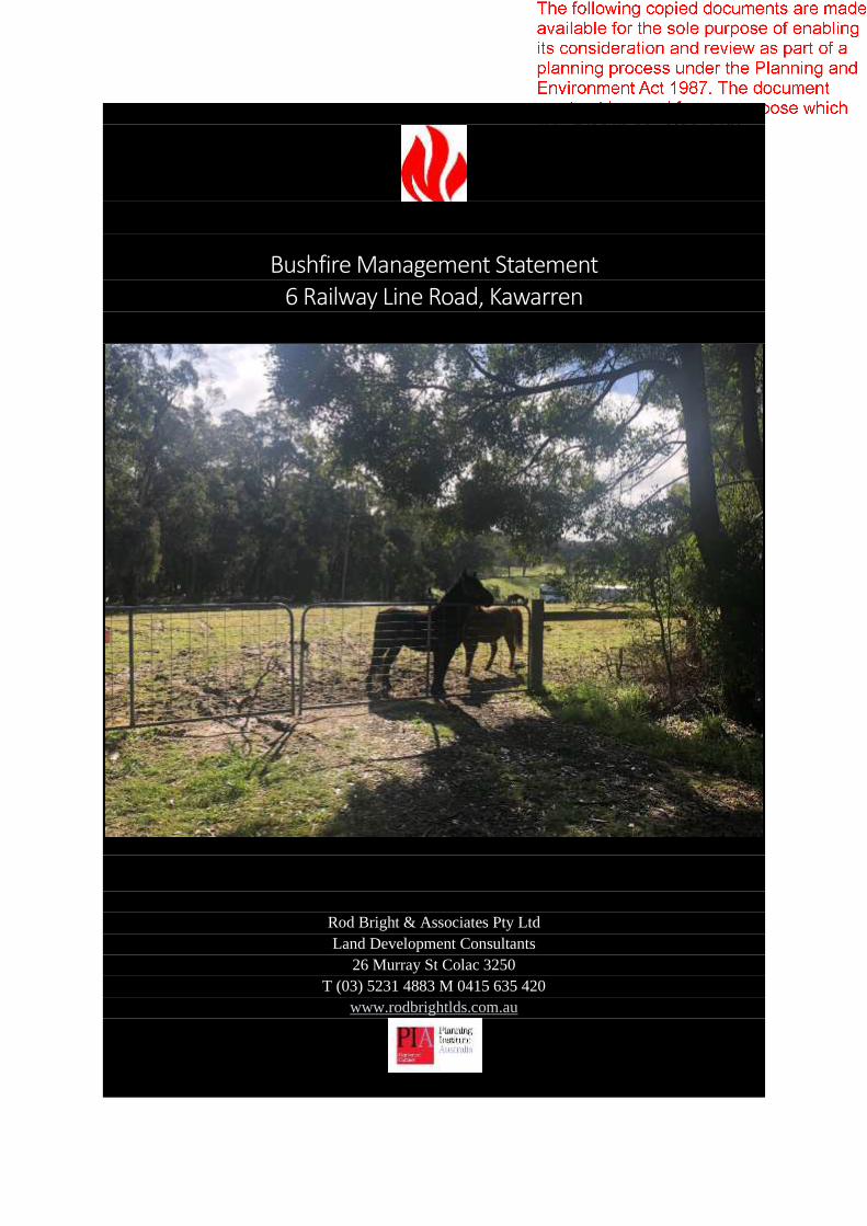
Bushfire Management Statement 6 Railway Line Road, Kawarren
Rod Bright & Associates Pty Ltd
Land Development Consultants
26 Murray St Colac 3250
T (03) 5231 4883 M 0415 635 420
www.rodbrightlds.com.au

Rod Bright & Associates Pty. Ltd. ACN 007 206 975 20-26 V1.1 25.09.20 p1
V1.1 11.09.2020 Draft for client discussion
V1.2 25.09.2020 Planning application
Rod Bright & Associates Pty. Ltd. ACN 007 206 975 20-26 V1.1 25.09.20 p2
Table of Contents
Executive Summary ........................................................................................................... 3 1.0 Introduction ............................................................................................................ 4
1.1 Scope ........................................................................................................................ 4 1.2 Methodology ............................................................................................................ 4 1.3 Proposal ................................................................................................................... 5 1.4 Planning Provisions .................................................................................................. 5
2.0 Site description ....................................................................................................... 6 2.1 Title particulars and location.................................................................................... 6 2.2 Site description ........................................................................................................ 7 2.3 Site shape, dimensions, size, topography: ............................................................... 8 2.4 Existing use and development on the site: .............................................................. 9 2.5 Existing access arrangements. ............................................................................... 10 2.6 Existing vegetation within the site. ........................................................................ 13 2.7 Other site features/constraints relevant to bushfire hazard. ................................ 18 2.8 Existing use, development and vegetation on adjoining sites ............................... 18
3.0 Bushfire Hazard Site Assessment ........................................................................... 22 3.1 Bushfire Hazard Site Assessment Plan ................................................................... 22 3.2 Vegetation classification & effective slope ............................................................ 23 3.3 Defendable Space and Building attack level (BAL) ................................................. 24 3.4 Defendable Space and Construction Requirements .............................................. 24
4.0 Bushfire Hazard Landscape Assessment ................................................................. 26 4.1 Bushfire Hazard Landscape Image. ........................................................................ 26 4.2 Landscape Bushfire Hazard .................................................................................... 27
5.0 Bushfire Management Statement .......................................................................... 28 5.1 Bushfire Planning Purpose ..................................................................................... 28 5.5 Bushfire Planning Assessment ............................................................................... 30
6.0 Additional Recommendations ................................................................................ 31 7.0 References ............................................................................................................ 32 8.0 Attachments ......................................................................................................... 33
8.1 Bushfire Management Plan. ................................................................................... 33 8.2 Tank Connections. .................................................................................................. 35 8.3 Planning Property Report ....................................................................................... 37
Rod Bright & Associates Pty. Ltd. ACN 007 206 975 20-26 V1.1 25.09.20 p3
Executive Summary
This report responds to the Bushfire Protection Planning Provisions of the Colac Otway Planning
Scheme and the Victorian Planning Provisions (VPPs), in relation to a proposed dwelling at 6 Railway
Line Road, Kawarren.
The report provides an assessment in relation to the objectives and mandatory standards for bushfire
protection in the context of the proposed farm dwelling.
All mandatory objectives and approved measures can be met within the property.
The ongoing implementation of the fire protection measures outlined in this document and within the
accompanying Bushfire Management Plan will ensure that risk to property and life from bushfire is
minimised.
Rod Bright & Associates Pty. Ltd. ACN 007 206 975 20-26 V1.1 25.09.20 p4
1.0 Introduction
1.1 Scope
Bond Homes on behalf of Lisa Hodge have engaged Rod Bright & Associates Pty Ltd to undertake a
bushfire management statement and plan to satisfy the requirements of the Bushfire Management
Overlay in relation to a proposed dwelling at Riches Access/Railway Line Road, Kawarren.
The land is affected by the Bushfire Management Overlay (BMO), which has the following purpose:
▪ To implement the Municipal Planning Strategy and the Planning Policy Framework;
▪ To ensure that the development of land prioritises the protection of human life and strengthens
community resilience to bushfire;
▪ To identify areas where the bushfire hazard warrants bushfire protection measures to be
implemented;
▪ To ensure development is only permitted where the risk to life and property from bushfire can
be reduced to an acceptable level.
Clause 53.02 Bushfire Planning has the following purpose furthering the intention of the BMO:
• To ensure that the location, design and construction of development appropriately responds to
the bushfire hazard.
• To specify location, design and construction measures for a single dwelling that reduces the
bushfire risk to life and property to an acceptable level.
This report seeks to respond to the above requirements in the context of the proposed dwelling, and
addresses relevant Bushfire planning strategies and principles of the Victorian Planning Provisions, the
planning requirements for bushfire - provisions of Clause 53.02 of the Colac Otway Planning Scheme,
and AS3959-2018 Construction of Buildings in Bushfire–prone Areas, as applicable.
A Schedule to the BMO does not apply to the subject land.
1.2 Methodology
A site inspection and assessment was undertaken on 20 August 2020. Photos contained within this
report are from this day, unless otherwise marked.
Aerial images are from Google Earth Pro, the Victorian Government or courtesy of Colac Otway Shire.
Effective slope has been either based on site measurements by a digital clinometer or calculated using
on-line contour information.
Vegetation has been classified using the CFA Document “Vegetation Classes in the Victorian Bushfire
Management Overlay” 2014.

Rod Bright & Associates Pty. Ltd. ACN 007 206 975 20-26 V1.1 25.09.20 p5
1.3 Proposal
The proposal is to use and develop the land for a dwelling & shed. The dwelling location has been
identified and plans have been viewed (20-100 25.05.2020) as part of this assessment.
The land will continue to be grazed by horses.
A detailed description of the site and surrounds is provided later in this report.
1.4 Planning Provisions
Under the provisions of the Colac Otway Planning Scheme:
• The land is zoned Rural Living (RLZ),
• Land adjacent to the site along the western boundary is zoned Road Zone Category 1 (RDZ1).
The following overlays apply:
• Bushfire Management Overlay (BMO),
• Erosion Management Overlay: Schedule 1 (EMO1) - Land susceptible to landslip and erosion,
• Environment Significance Overlay: Schedule 3 (ESO3) – Declared water supply catchments.
Part of the land is within 200 metres of Loves Creek and is located within an area of Aboriginal Cultural
Heritage Significance.
Refer to Attachments for planning scheme maps.
Relevant sections of the Planning Policy Framework are referred to in Section 5 of this report.
Rod Bright & Associates Pty. Ltd. ACN 007 206 975 20-26 V1.1 25.09.20 p6
2.0 Site description
2.1 Title particulars and location
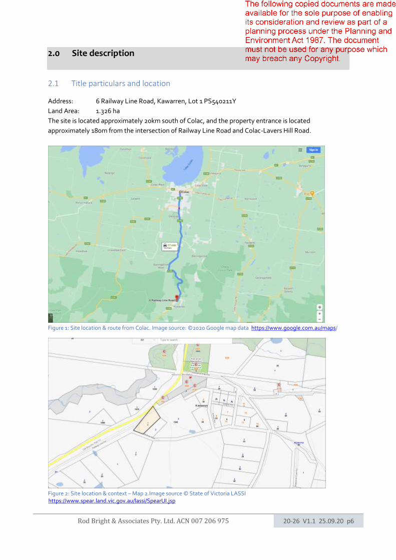
Address: 6 Railway Line Road, Kawarren, Lot 1 PS540211Y
Land Area: 1.326 ha
The site is located approximately 20km south of Colac, and the property entrance is located
approximately 180m from the intersection of Railway Line Road and Colac-Lavers Hill Road.
Figure 1: Site location & route from Colac. Image source: ©2020 Google map data https://www.google.com.au/maps/
Figure 2: Site location & context – Map 2.Image source © State of Victoria LASSI https://www.spear.land.vic.gov.au/lassi/SpearUI.jsp
Rod Bright & Associates Pty. Ltd. ACN 007 206 975 20-26 V1.1 25.09.20 p7
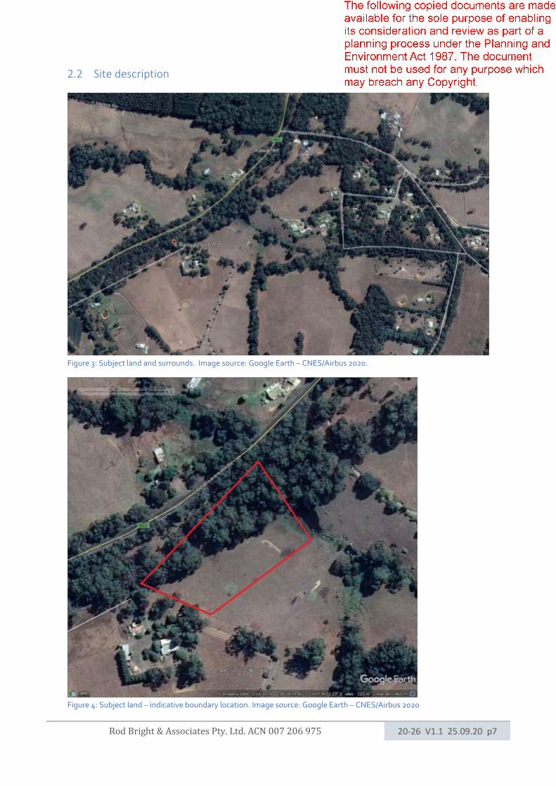
2.2 Site description
Figure 3: Subject land and surrounds. Image source: Google Earth – CNES/Airbus 2020.
Figure 4: Subject land – indicative boundary location. Image source: Google Earth – CNES/Airbus 2020
Rod Bright & Associates Pty. Ltd. ACN 007 206 975 20-26 V1.1 25.09.20 p8
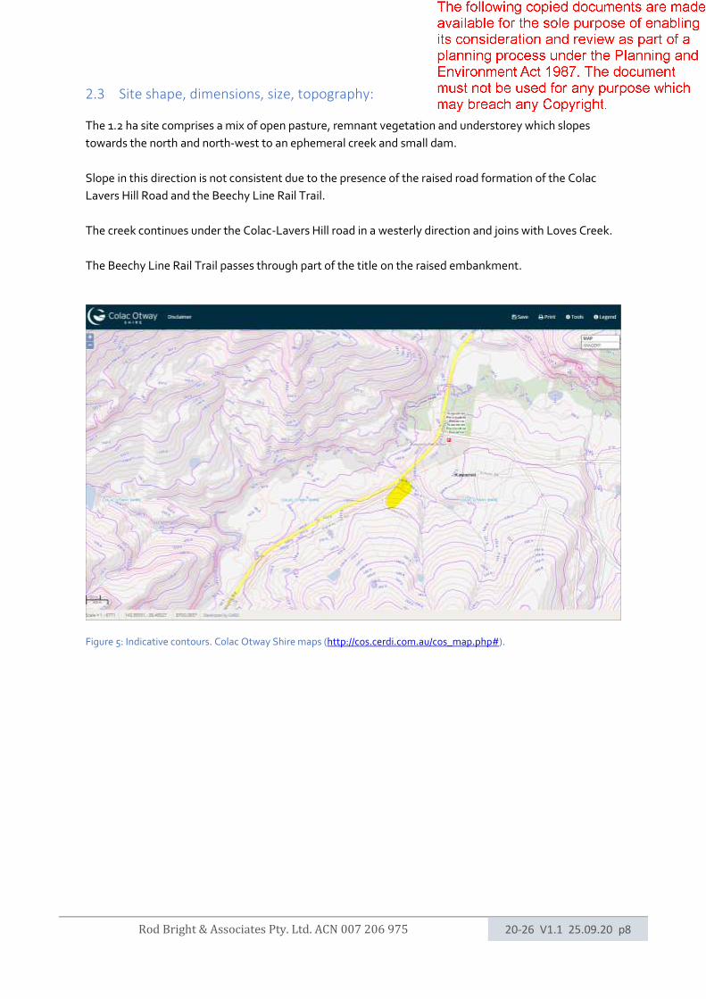
2.3 Site shape, dimensions, size, topography:
The 1.2 ha site comprises a mix of open pasture, remnant vegetation and understorey which slopes
towards the north and north-west to an ephemeral creek and small dam.
Slope in this direction is not consistent due to the presence of the raised road formation of the Colac
Lavers Hill Road and the Beechy Line Rail Trail.
The creek continues under the Colac-Lavers Hill road in a westerly direction and joins with Loves Creek.
The Beechy Line Rail Trail passes through part of the title on the raised embankment.
Figure 5: Indicative contours. Colac Otway Shire maps (http://cos.cerdi.com.au/cos_map.php#).
Rod Bright & Associates Pty. Ltd. ACN 007 206 975 20-26 V1.1 25.09.20 p9
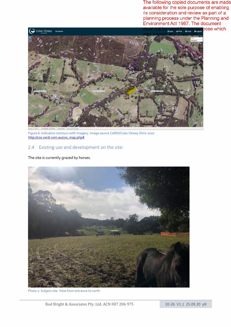
Figure 6: Indicative contours with imagery. Image source CeRDI/Colac Otway Shire 2020 http://cos.cerdi.com.au/cos_map.php#
2.4 Existing use and development on the site:
The site is currently grazed by horses.
Photo 1: Subject site. View from entrance to north.
Rod Bright & Associates Pty. Ltd. ACN 007 206 975 20-26 V1.1 25.09.20 p10
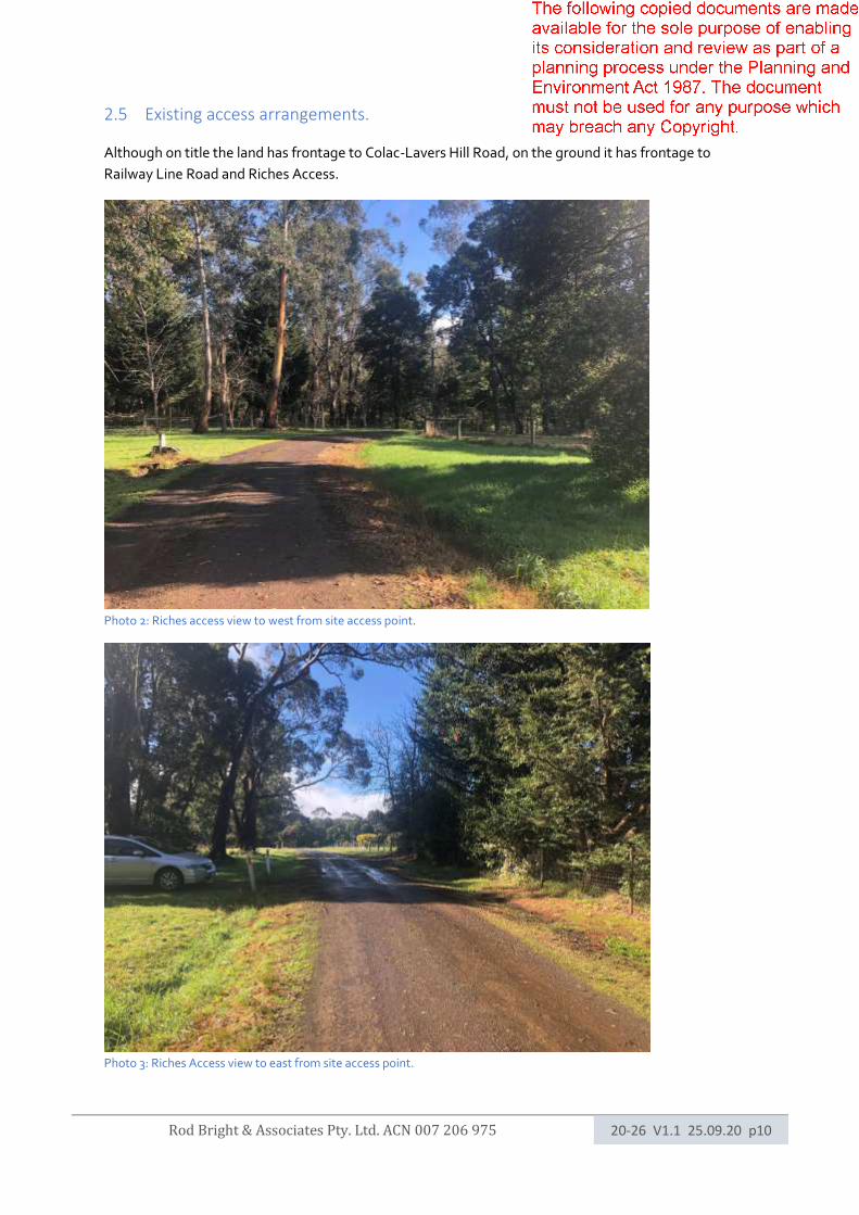
2.5 Existing access arrangements.
Although on title the land has frontage to Colac-Lavers Hill Road, on the ground it has frontage to
Railway Line Road and Riches Access.
Photo 2: Riches access view to west from site access point.
Photo 3: Riches Access view to east from site access point.
Rod Bright & Associates Pty. Ltd. ACN 007 206 975 20-26 V1.1 25.09.20 p11
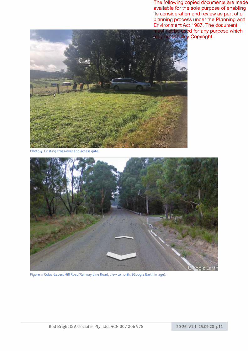
Photo 4: Existing cross-over and access gate.
Figure 7: Colac-Lavers Hill Road/Railway Line Road, view to north. (Google Earth image).
Rod Bright & Associates Pty. Ltd. ACN 007 206 975 20-26 V1.1 25.09.20 p12
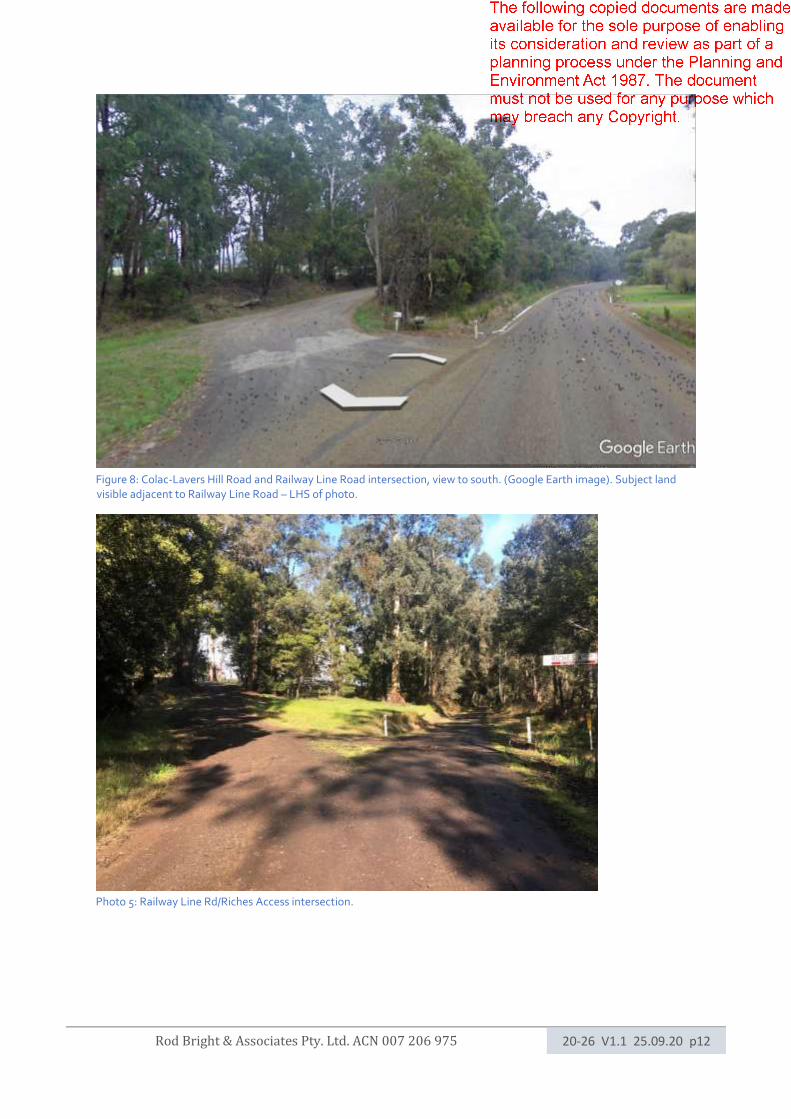
Figure 8: Colac-Lavers Hill Road and Railway Line Road intersection, view to south. (Google Earth image). Subject land visible adjacent to Railway Line Road – LHS of photo.
Photo 5: Railway Line Rd/Riches Access intersection.

Rod Bright & Associates Pty. Ltd. ACN 007 206 975 20-26 V1.1 25.09.20 p13
2.6 Existing vegetation within the site.
Vegetation comprises areas of cleared pasture with remnant vegetation to the north and west.
The vegetation has been classified under AS3959 for the purposes of this report using the document
Vegetation Classes within the Victorian Bushfire Management Overlay (2014).
Dominant vegetation within the site is classified as “Forest” and “Grassland”. A site assessment
identifies that vegetation is likely to be Forest (wet)) due to the presence of tall eucalypts and strong
presence of understorey acacia trees with rainfall exceeding a mean of 1000mm per year (Forrest State
Forest weather station, 2019, BOM). The vegetation in areas may have been disturbed, perhaps as part
of construction of the roads and railway lines.
Vegetation is classified by Ecological Vegetation Class (EVC) 16 Lowland Forest – Otway Plains
Bioregion. Typical Eucalyptus species found in the canopy layer include: Eucalyptus obliqua- Messmate
Stringybark, Eucalyptus baxteri s.l. Brown Stringybark.
For the purposes of this report the vegetation is classified as Forest and Grassland (pasture) within 150m
of the proposed building envelope as required by Clause 44.06-3 and AS3959:2018.
An additional level of modification to the Forest vegetation within the site is evident due to presence of
grazing animals. Vegetation between the creek and the east side of the Colac Lavers Hill Road has a
heavy understorey and is typical of understorey fuel in the area. For this reason, and the potential for
regeneration, Forest is not classified as modified in this direction from the dwelling.
The creek running through adjacent land to the north have potential for vegetation regeneration. The
future fuel load potential of these creek-lines is not easily predicted.
Defendable space is determined having regard to the highest risk vegetation within 150m of the site also
in accordance with the standard.
The photos on the following page indicate observed vegetation.
Rod Bright & Associates Pty. Ltd. ACN 007 206 975 20-26 V1.1 25.09.20 p14
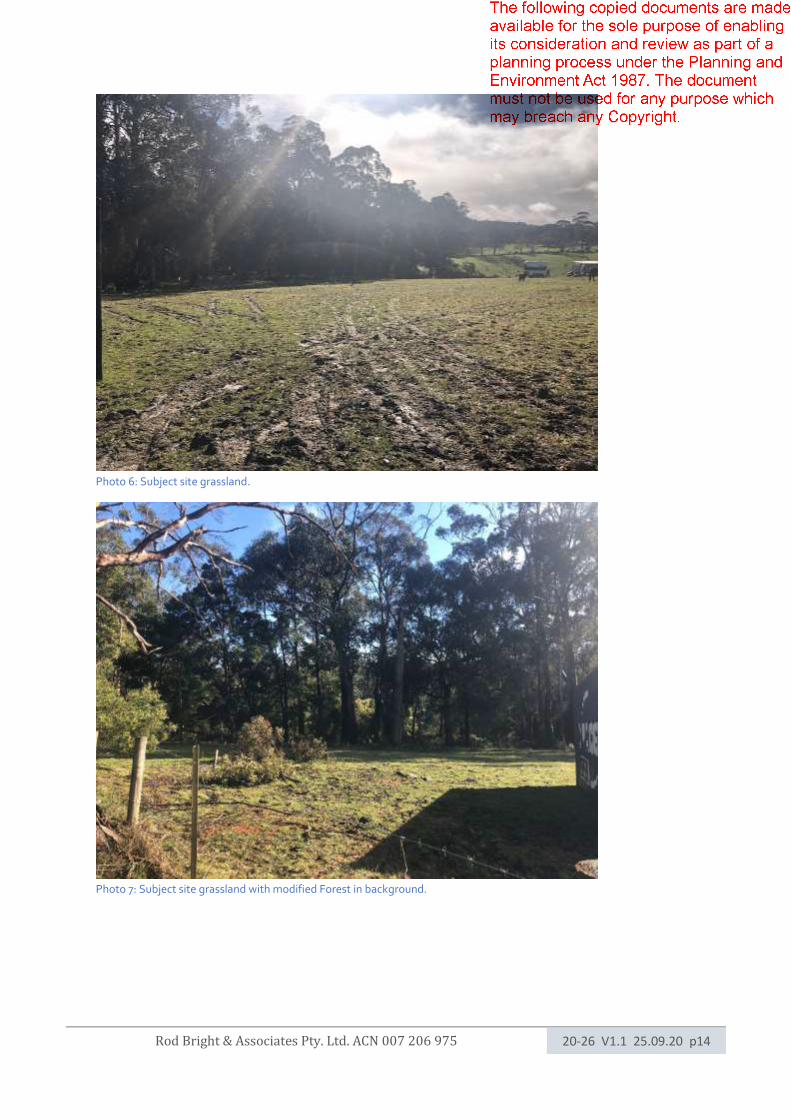
Photo 6: Subject site grassland.
Photo 7: Subject site grassland with modified Forest in background.
Rod Bright & Associates Pty. Ltd. ACN 007 206 975 20-26 V1.1 25.09.20 p15
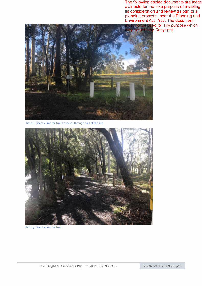
Photo 8: Beechy Line rail trail traverses through part of the site.
Photo 9: Beechy Line rail trail.
Rod Bright & Associates Pty. Ltd. ACN 007 206 975 20-26 V1.1 25.09.20 p16
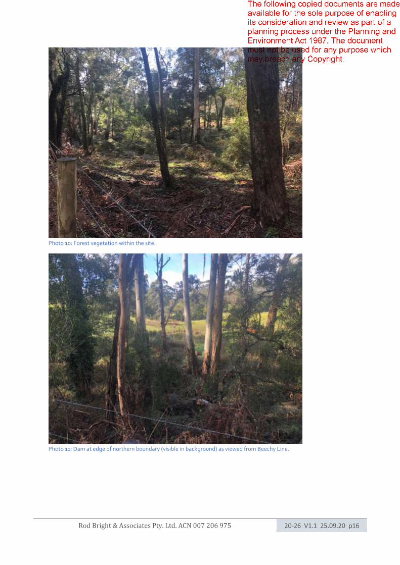
Photo 10: Forest vegetation within the site.
Photo 11: Dam at edge of northern boundary (visible in background) as viewed from Beechy Line.
Rod Bright & Associates Pty. Ltd. ACN 007 206 975 20-26 V1.1 25.09.20 p17
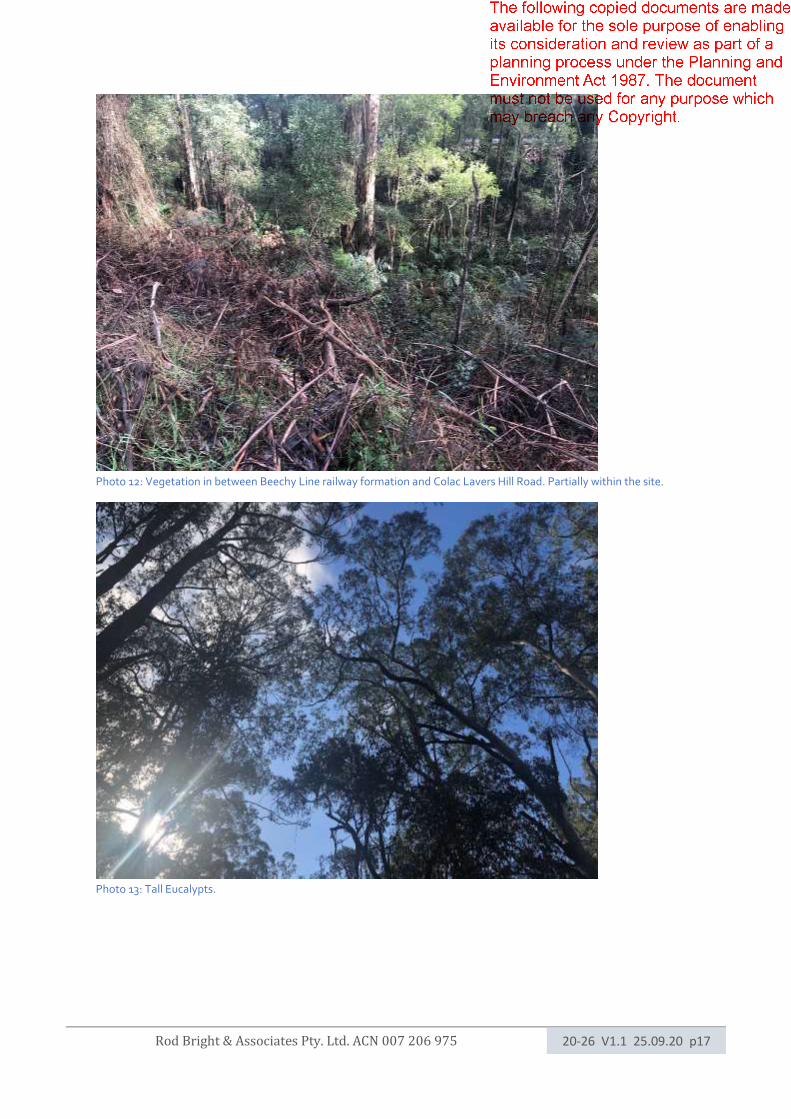
Photo 12: Vegetation in between Beechy Line railway formation and Colac Lavers Hill Road. Partially within the site.
Photo 13: Tall Eucalypts.
Rod Bright & Associates Pty. Ltd. ACN 007 206 975 20-26 V1.1 25.09.20 p18
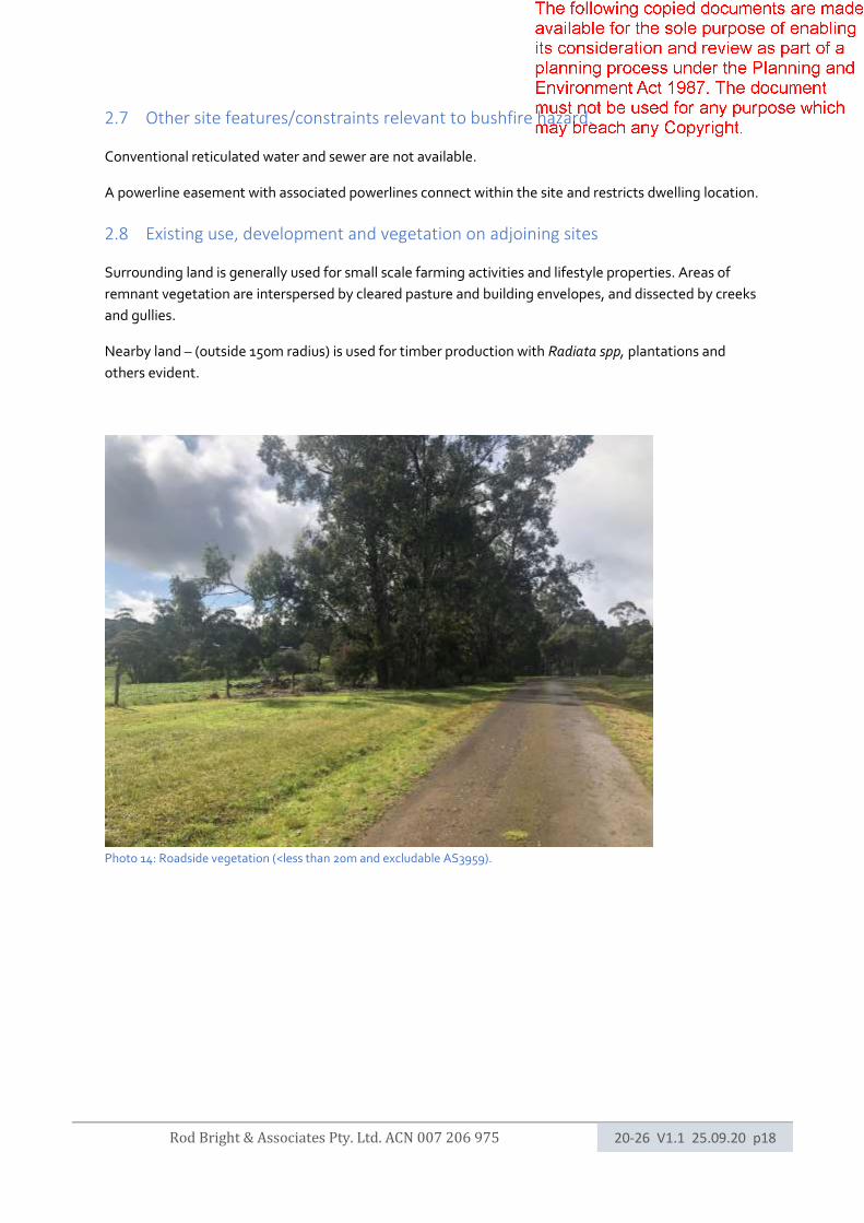
2.7 Other site features/constraints relevant to bushfire hazard.
Conventional reticulated water and sewer are not available.
A powerline easement with associated powerlines connect within the site and restricts dwelling location.
2.8 Existing use, development and vegetation on adjoining sites
Surrounding land is generally used for small scale farming activities and lifestyle properties. Areas of
remnant vegetation are interspersed by cleared pasture and building envelopes, and dissected by creeks
and gullies.
Nearby land – (outside 150m radius) is used for timber production with Radiata spp, plantations and
others evident.
Photo 14: Roadside vegetation (<less than 20m and excludable AS3959).
Rod Bright & Associates Pty. Ltd. ACN 007 206 975 20-26 V1.1 25.09.20 p19
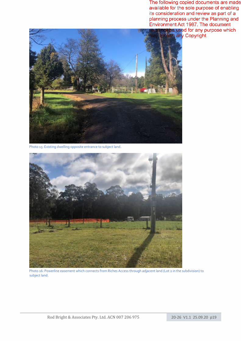
Photo 15: Existing dwelling opposite entrance to subject land.
Photo 16: Powerline easement which connects from Riches Access through adjacent land (Lot 2 in the subdivision) to subject land.

Rod Bright & Associates Pty. Ltd. ACN 007 206 975 20-26 V1.1 25.09.20 p20
Photo 17: Land opposite and upslope from proposed dwelling site.
Photo 18: Eucalyptus with shedding bark.
Rod Bright & Associates Pty. Ltd. ACN 007 206 975 20-26 V1.1 25.09.20 p21
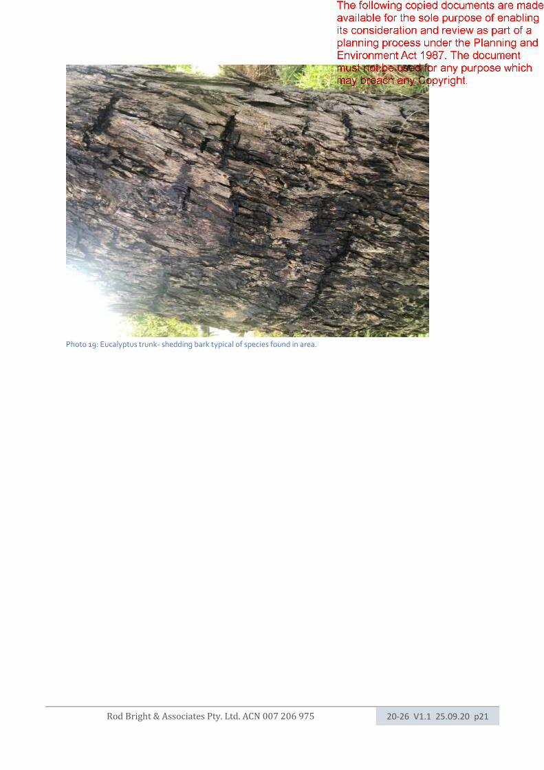
Photo 19: Eucalyptus trunk- shedding bark typical of species found in area.
Rod Bright & Associates Pty. Ltd. ACN 007 206 975 20-26 V1.1 25.09.20 p22
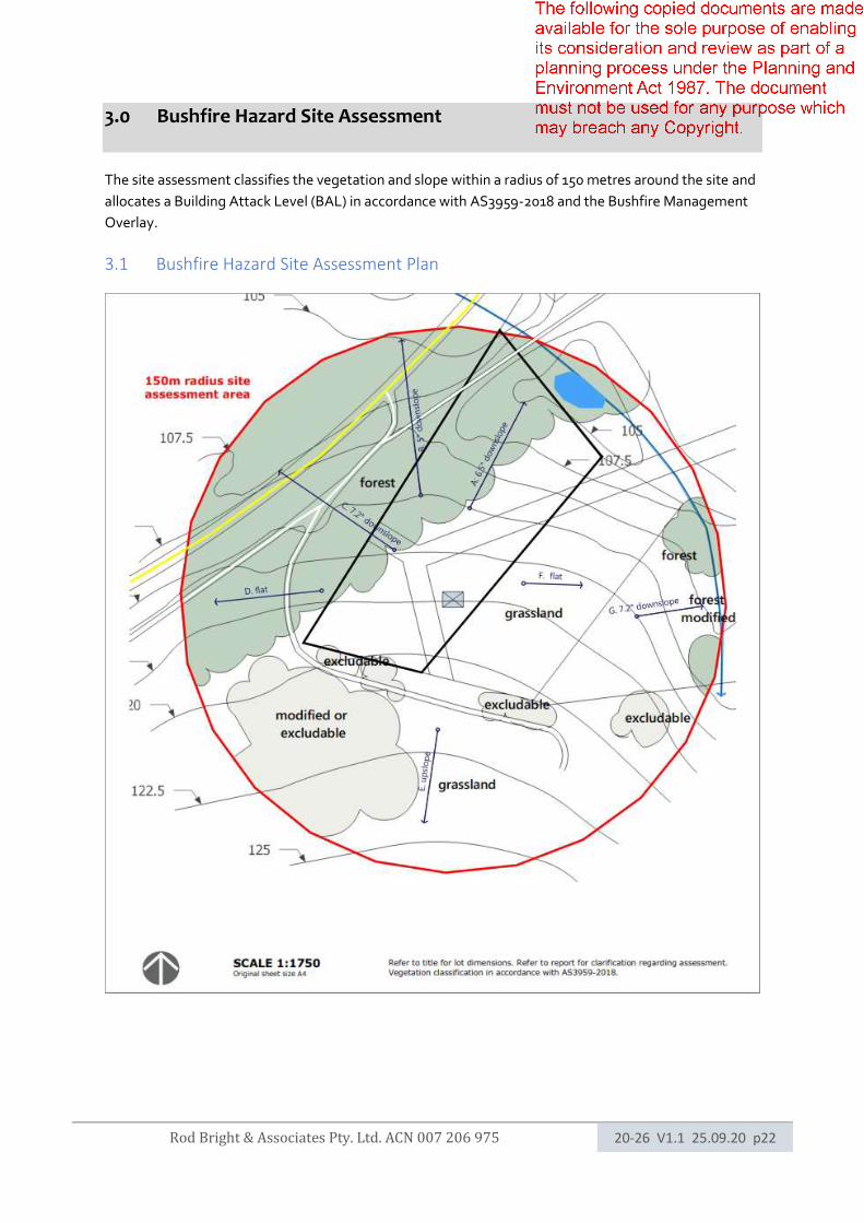
3.0 Bushfire Hazard Site Assessment
The site assessment classifies the vegetation and slope within a radius of 150 metres around the site and
allocates a Building Attack Level (BAL) in accordance with AS3959-2018 and the Bushfire Management
Overlay.
3.1 Bushfire Hazard Site Assessment Plan
Rod Bright & Associates Pty. Ltd. ACN 007 206 975 20-26 V1.1 25.09.20 p23
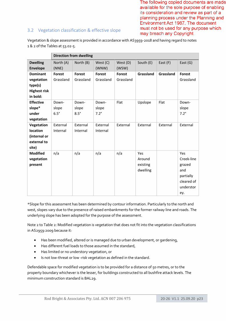
3.2 Vegetation classification & effective slope
Vegetation & slope assessment is provided in accordance with AS3959-2018 and having regard to notes
1 & 2 of the Tables at 53.02-5.
Direction from dwelling
Dwelling
Envelope
North (A)
(NNE)
North (B) West (C)
(WNW)
West (D)
(WSW)
South (E) East (F) East (G)
Dominant
vegetation
type(s)
Highest risk
in bold:
Forest
Grassland
Forest
Grassland
Forest
Grassland
Forest
Grassland
Grassland Grassland Forest
Grassland
Effective
slope*
under
vegetation
Down-
slope
6.5°
Down-
slope
8.5°
Down-
slope
7.2°
Flat
Upslope
Flat Down-
slope
7.2°
Vegetation
location
(internal or
external to
site)
External
Internal
External
Internal
External
Internal
External External External External
Modified
vegetation
present
n/a n/a n/a n/a Yes
Around
existing
dwelling
Yes
Creek-line
grazed
and
partially
cleared of
understor
ey.
*Slope for this assessment has been determined by contour information. Particularly to the north and
west, slopes vary due to the presence of raised embankments for the former railway line and roads. The
underlying slope has been adopted for the purpose of the assessment.
Note 2 to Table 2: Modified vegetation is vegetation that does not fit into the vegetation classifications
in AS2959:2009 because it:
• Has been modified, altered or is managed due to urban development, or gardening,
• Has different fuel loads to those assumed in the standard,
• Has limited or no understory vegetation, or
• Is not low-threat or low -risk vegetation as defined in the standard.
Defendable space for modified vegetation is to be provided for a distance of 50 metres, or to the
property boundary whichever is the lesser, for buildings constructed to all bushfire attack levels. The
minimum construction standard is BAL29.
Rod Bright & Associates Pty. Ltd. ACN 007 206 975 20-26 V1.1 25.09.20 p24
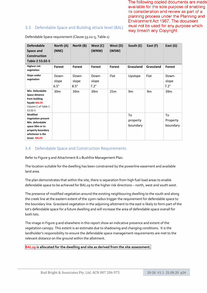
3.3 Defendable Space and Building attack level (BAL)
Defendable Space requirement (Clause 53.02-5, Table 1)
Defendable
Space and
Construction
Table 2 53.02-5
North (A)
(NNE)
North (B) West (C)
(WNW)
West (D)
(WSW)
South (E) East (F) East (G)
Highest risk
vegetation Forest
Forest
Forest
Forest
Grassland Grassland Forest
Slope under
vegetation Down-
slope
6.5°
Down-
slope
8.5°
Down-
slope
7.2°
Flat
Upslope
Flat Down-
slope
7.2°
Min. Defendable
Space distance
from building
façade BAL29
Column C of Table 1
53.02-5
39m 39m 39m 25m 9m 9m 39m
Modified
Vegetation present
Min. defendable
space 50m or to
property boundary
whichever is the
lesser. BAL29
To
property
boundary
To
Property
boundary
3.4 Defendable Space and Construction Requirements
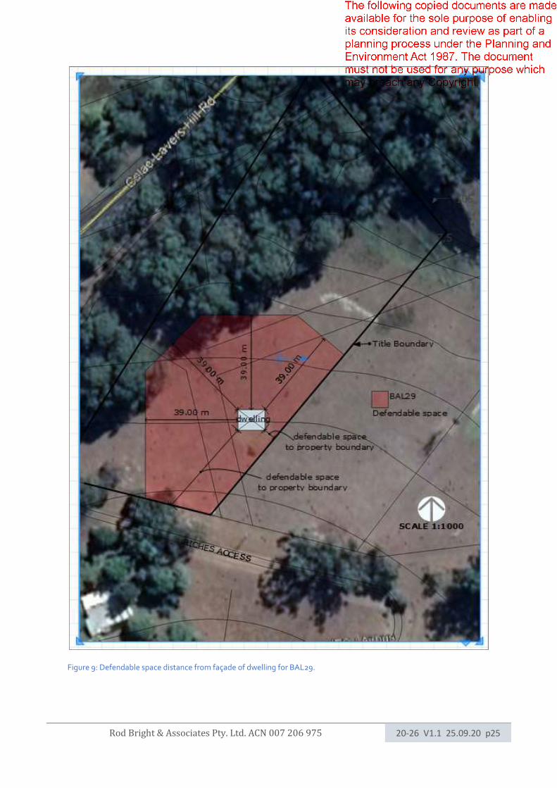
Refer to Figure 9 and Attachment 8.1 Bushfire Management Plan.
The location suitable for the dwelling has been constrained by the powerline easement and available
land area.
The plan demonstrates that within the site, there is separation from high fuel load areas to enable
defendable space to be achieved for BAL29 to the higher risk directions – north, west and south west.
The presence of modified vegetation around the existing neighbouring dwelling to the south and along
the creek line at the eastern extent of the 150m radius trigger the requirement for defendable space to
the boundary line. Grassland vegetation in the adjoining allotment to the east is likely to form part of the
lot’s defendable space for a future dwelling and will increase the area of defendable space overall for
both lots.
The image in Figure 9 and elsewhere in this report show an indicative presence and extent of the
vegetation canopy. This extent is an estimate due to shadowing and changing conditions. It is the
landholder’s responsibility to ensure the defendable space management requirements are met to the
relevant distance on the ground within the allotment.
BAL29 is allocated for the dwelling and site as derived from the site assessment.
Rod Bright & Associates Pty. Ltd. ACN 007 206 975 20-26 V1.1 25.09.20 p25
Figure 9: Defendable space distance from façade of dwelling for BAL29.

Rod Bright & Associates Pty. Ltd. ACN 007 206 975 20-26 V1.1 25.09.20 p26
4.0 Bushfire Hazard Landscape Assessment
4.1 Bushfire Hazard Landscape Image.
Figure 10: Bushfire hazard landscape image. Heavy vegetation fuel environment with potential for long fire runs, more than 30km if uncontrolled from the west/south west.
Rod Bright & Associates Pty. Ltd. ACN 007 206 975 20-26 V1.1 25.09.20 p27
4.2 Landscape Bushfire Hazard
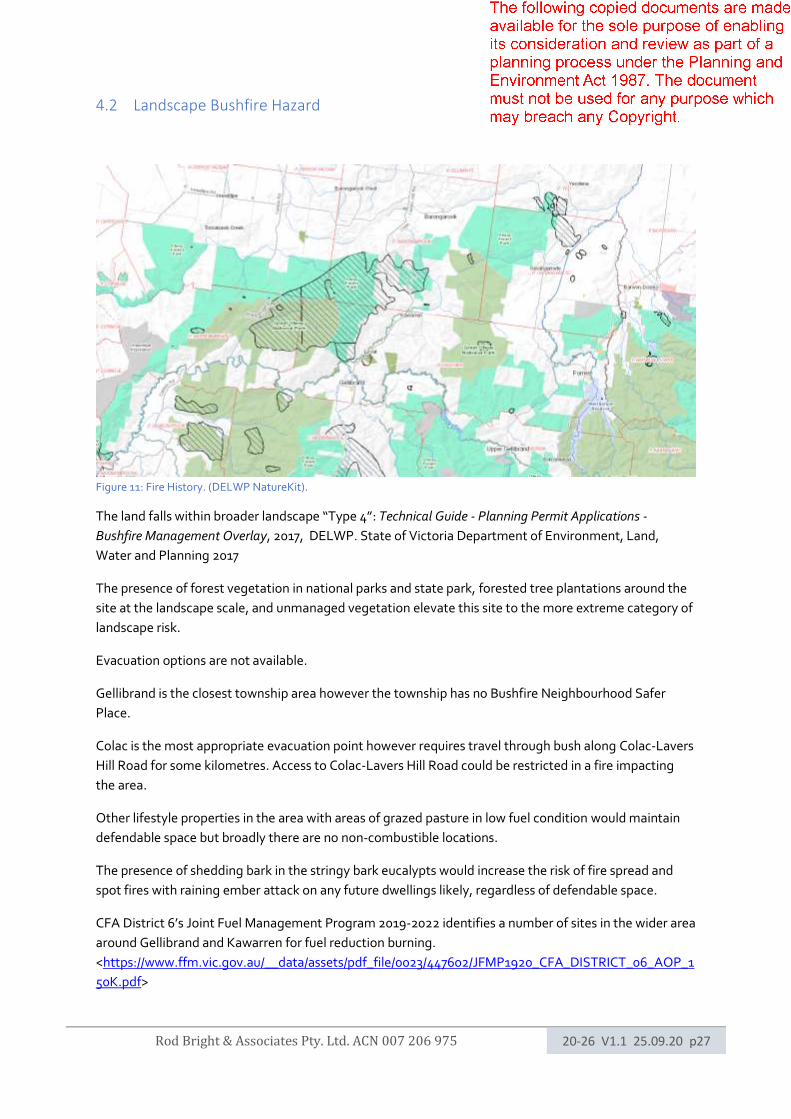
Figure 11: Fire History. (DELWP NatureKit).
The land falls within broader landscape “Type 4”: Technical Guide - Planning Permit Applications -
Bushfire Management Overlay, 2017, DELWP. State of Victoria Department of Environment, Land,
Water and Planning 2017
The presence of forest vegetation in national parks and state park, forested tree plantations around the
site at the landscape scale, and unmanaged vegetation elevate this site to the more extreme category of
landscape risk.
Evacuation options are not available.
Gellibrand is the closest township area however the township has no Bushfire Neighbourhood Safer
Place.
Colac is the most appropriate evacuation point however requires travel through bush along Colac-Lavers
Hill Road for some kilometres. Access to Colac-Lavers Hill Road could be restricted in a fire impacting
the area.
Other lifestyle properties in the area with areas of grazed pasture in low fuel condition would maintain
defendable space but broadly there are no non-combustible locations.
The presence of shedding bark in the stringy bark eucalypts would increase the risk of fire spread and
spot fires with raining ember attack on any future dwellings likely, regardless of defendable space.
CFA District 6’s Joint Fuel Management Program 2019-2022 identifies a number of sites in the wider area
around Gellibrand and Kawarren for fuel reduction burning.
<https://www.ffm.vic.gov.au/__data/assets/pdf_file/0023/447602/JFMP1920_CFA_DISTRICT_06_AOP_1
50K.pdf>
Rod Bright & Associates Pty. Ltd. ACN 007 206 975 20-26 V1.1 25.09.20 p28
5.0 Bushfire Management Statement
The following section provides a site-specific response to the Bushfire Protection – Planning
requirements (Clause 53.02) of the Victorian Planning Provisions (VPPs) and the Bushfire Protection
Objectives of 52.03-3 and/or 53.02-4.
5.1 Bushfire Planning Purpose
The purpose of the Bushfire Planning Provisions of 53.02 are:
• To Implement the Municipal Planning Strategy and the Planning Policy Framework
• To ensure the development of land prioritises the protection of human life and strengthens
community resilience to bushfire,
• To ensure that the location, design, construction of development appropriately responds to the
bushfire hazard,
• To ensure development is only permitted where the risk to life, property and community
infrastructure from bushfire can be reduced to an acceptable level.
• To specify location, design and construction measures for a single dwelling that reduces the
bushfire risk to life and property to an acceptable level.
Dwellings in existing settlements - application: PATHWAY 1: Clause 53.02-3 applies to this permit
application. The land is within a Rural Living Zone, there will only be one dwelling on the lot, and
the application meets all of the approved measures contained in clause 53.02-3 and described
below.
Approved
Measures
Requirement Response
AM1.1 A building is sited to ensure the site best
achieves the following:
• The maximum separation distance
between the building and the bushfire
hazards;
• The building is in close proximity to a
public road.
Access can be provided to the building for
emergency service vehicles.
The proposed building location achieves
maximum separation from the risk in the
context of other site constraints.
The building is in close proximity to a
public road, including the sealed Colac-
Lavers Hill Road.
Access can be provided for emergency
vehicles.
AM1.2 A building provides the defendable space in
accordance with Table 1 Columns A, B, C,
D or E and Table 6 to Clause 53.02-5.
Adjoining land may be included as
defendable space where there is a
reasonable assurance that the land will
remain or continue to be managed in that
condition as part of the defendable
space.
Defendable space for BAL29 will be
provided wholly within the title
boundaries of the land.
In the future it is likely to merge with
adjoining land defendable space when
that lot is developed.

Rod Bright & Associates Pty. Ltd. ACN 007 206 975 20-26 V1.1 25.09.20 p29
A building is constructed to the bushfire
attack level:
• That corresponds to the defendable
space provided in accordance with
Table 1 to Clause 53.02-5, or
• The next lower bushfire attack level
that corresponds to the defendable
space provided in accordance with
Table 1 to Clause 53.02-5 where all of
the following apply:
o A private bushfire shelter (a
Class 10c building within the
meaning of the Building
Regulations 2006) is
constructed on the same
land as the dwelling.
o A minimum bushfire attack
level of BAL12.5 is provided
in all circumstances.
Refer to the accompanying bushfire
management plan.
The plan requires a building to be
constructed to the corresponding BAL29
(AS3959-2018) or as amended.
The key setbacks are 32m from the tree
canopy to the north and west of the house
site, and to the south and east to the
property line.
The eastern boundary is approx. 6m from
the proposed dwelling.
AM1.3 A building is provided with:
• A static water supply for fire fighting
and property protection purposes
specified in Table 4 to Clause 53.02-
5. The water supply may be in the
same tanks as other water supplies
provided that a separate outlet is
reserved for fire fighting water
supplies.
• Vehicle access that is designed and
constructed as specified in Table 5 to
Clause 53.02-5.
Static water supply and vehicle access to
be provided in accordance with CFA
standards.

Rod Bright & Associates Pty. Ltd. ACN 007 206 975 20-26 V1.1 25.09.20 p30
5.5 Bushfire Planning Assessment
State Bushfire planning policy (cl 13.02-1S) applies to the land.
Its objective is to strengthen the resilience of settlements and communities to bushfire through risk-based
planning that prioritises the protection of human life.
Strategies to achieve the objective relevant to this site and scenario comprise Protection of Human Life
Strategy and Bushfire hazard id and assessment, shown below:

Rod Bright & Associates Pty. Ltd. ACN 007 206 975 20-26 V1.1 25.09.20 p31
Despite Kawarren being an established settlement with many lifestyle properties and zoned Rural living,
the area and landscape risk is significant.
It is recommended that additional safety measures are implemented to assist in mitigating against the
wider landscape risk.
6.0 Additional Recommendations
The following recommendations are offered in respect to ensuring bushfire protection objectives are
achieved for site on an ongoing basis:
1. The future dwelling be constructed to comply with requirements of BAL29 or higher under
AS3959-2018, as noted on the plan.
2. Defendable space vegetation maintenance could be extended to the western extent of the
driveway entry point (Riches Access).
3. Clear access to water tanks or water points should be maintained at all times (and kept clear of
any vegetation).
4. Landholders could consider installing additional protection measures, such as sprinklers or
wetting devices on the dwelling and/or surrounding garden/landscape, using gutter guards and
valley guards, where not picked up through construction requirements under AS3959.
5. Landholders should consider bushfire safety in landscaping design, such as using non-
combustible materials in fencing and other landscape features. Specifically, no mulch or garden
beds should be installed abutting the dwelling.
6. If the adjacent land/property to the east is not maintained in low fuel condition, the owners
should consider installing a steel fence along part of the property boundary between the house
and grassland vegetation.
7. Landholders should consider the likely ember attack as the greatest bushfire threat to the site
and incorporate toughened glass, shutters and screens for window protection, where not
required under AS3959.
8. Landholders should consider installing a VBA-accredited private bushfire bunker as last resort
protection, given the difficulty of evacuation from this location.
9. Landholders should familiarise themselves with current CFA advice regarding fire farm
management planning and property preparation, in addition to personal and dwelling planning
and preparation.
10. The deck, verandah and stairs – where these connect to the building façade, would be weaker
points providing combustion opportunities to the dwelling and use of non-combustible
materials for these is recommended.
Rod Bright & Associates Pty. Ltd. ACN 007 206 975 20-26 V1.1 25.09.20 p32
7.0 References
Publications:
Country Fire Authority, 2012, ‘Planning for Bushfire Victoria – Guidelines for Meeting Victoria’s Bushfire
Planning Requirements’, Version 2, November 2012.
Country Fire Authority, 2014, ‘Vegetation Classes in the Victorian Bushfire Management Overlay’.
Standards Australia, ‘As3959-2018 Construction of buildings in bushfire-prone areas’, November 2018.
https://www.standards.org.au/
State Government of Victoria, 2020, ‘Colac Otway Planning Scheme Ordinance’,
https://www.planning.vic.gov.au/schemes-and-amendments/browse-planning-scheme/planning-
scheme?f.Scheme%7CplanningSchemeName=Colac+Otway
State Government of Victoria, 2017, ‘Technical Guide - Planning Permit Applications - Bushfire
Management Overlay’, Department of Environment, Land, Water and Planning. Retrieved September
2020, https://www.planning.vic.gov.au/__data/assets/pdf_file/0029/107669/Technical-Guide-Planning-
Permit-Applications-Bushfire-Management-Overlay.pdf
State Government of Victoria, May 2008, ‘EVC/Bioregion Benchmark for Vegetation Quality Assessment
- Otway Ranges Bioregion EVC 16: Lowland Forest’, Victorian Department of Sustainability and
Environment, retrieved September 2020,
https://www.environment.vic.gov.au/__data/assets/pdf_file/0024/48741/OtR_EVCs_combined.pdf
Maps/GIS:
Colac Otway Shire, CeRDI, contour data GIS, retrieved September 2020,
<http://cos.cerdi.com.au/cos_map.php>
Google Earth Pro, 2020, satellite imagery, CNES, Airbus.
State Government of Victoria, 2020, Cadastre and survey information, LASSI: Land and Survey Spatial
Information, Department of Environment Land Water and Planning, retrieved September 2020,
https://maps.land.vic.gov.au/lassi/
State Government of Victoria, 2020, 2005 Ecological Vegetation Classes, Nature Kit, Department of
Environment Land Water and Planning, retrieved September 2020,
<http://maps.biodiversity.vic.gov.au/viewer/?viewer=NatureKit>
State Government of Victoria, 2020, Planning zones and overlay information, VicPlan, Department of
Environment Land Water and Planning, retrieved September 2020, https://mapshare.vic.gov.au/vicplan/

Rod Bright & Associates Pty. Ltd. ACN 007 206 975 20-26 V1.1 25.09.20 p33
8.0 Attachments
8.1 Bushfire Management Plan.
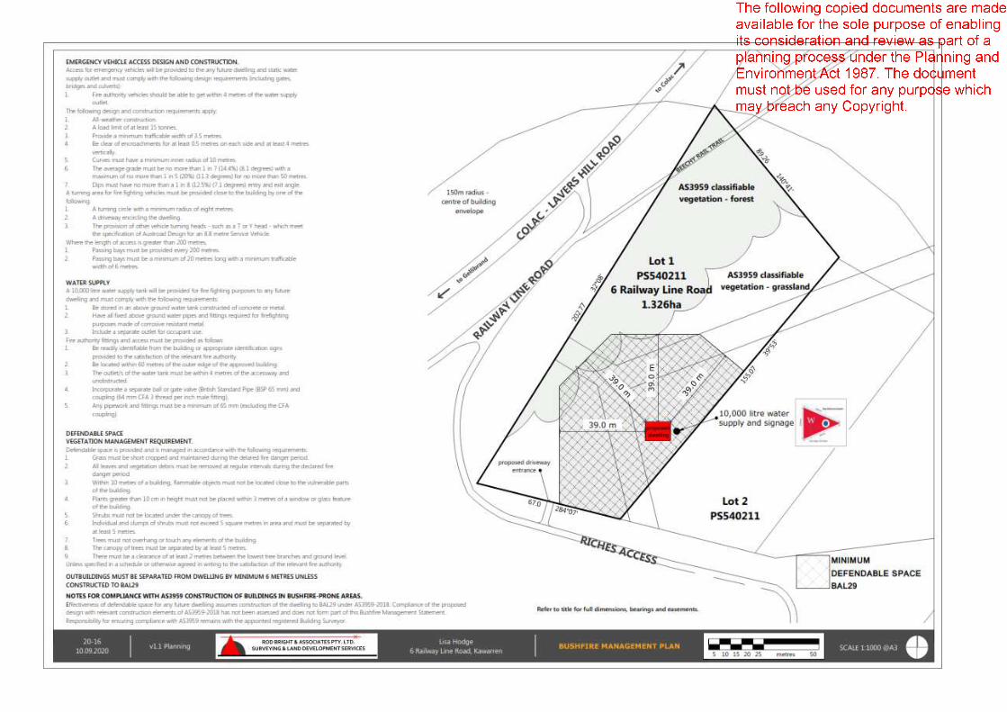
Rod Bright & Associates Pty. Ltd. ACN 007 206 975 20-26 V1.1 25.09.20 p34

Rod Bright & Associates Pty. Ltd. ACN 007 206 975 20-15 V1.2 24-07-20 p35
8.2 Tank Connections.
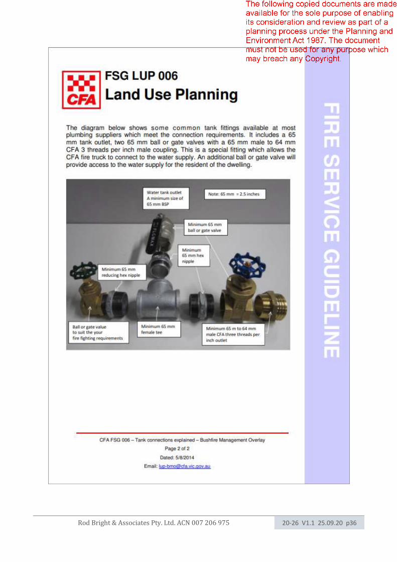
Rod Bright & Associates Pty. Ltd. ACN 007 206 975 20-26 V1.1 25.09.20 p36
Rod Bright & Associates Pty. Ltd. ACN 007 206 975 20-26 V1.1 25.09.20 p37
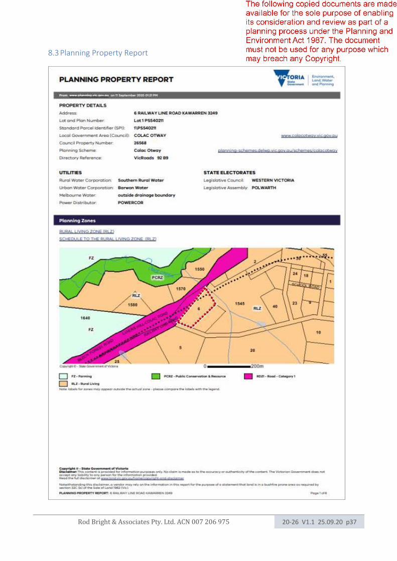
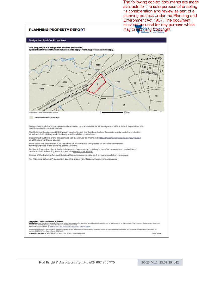
8.3 Planning Property Report
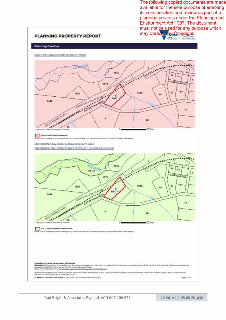
Rod Bright & Associates Pty. Ltd. ACN 007 206 975 20-26 V1.1 25.09.20 p38
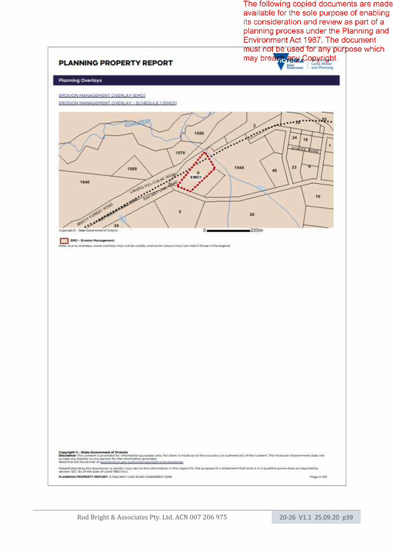
Rod Bright & Associates Pty. Ltd. ACN 007 206 975 20-26 V1.1 25.09.20 p39
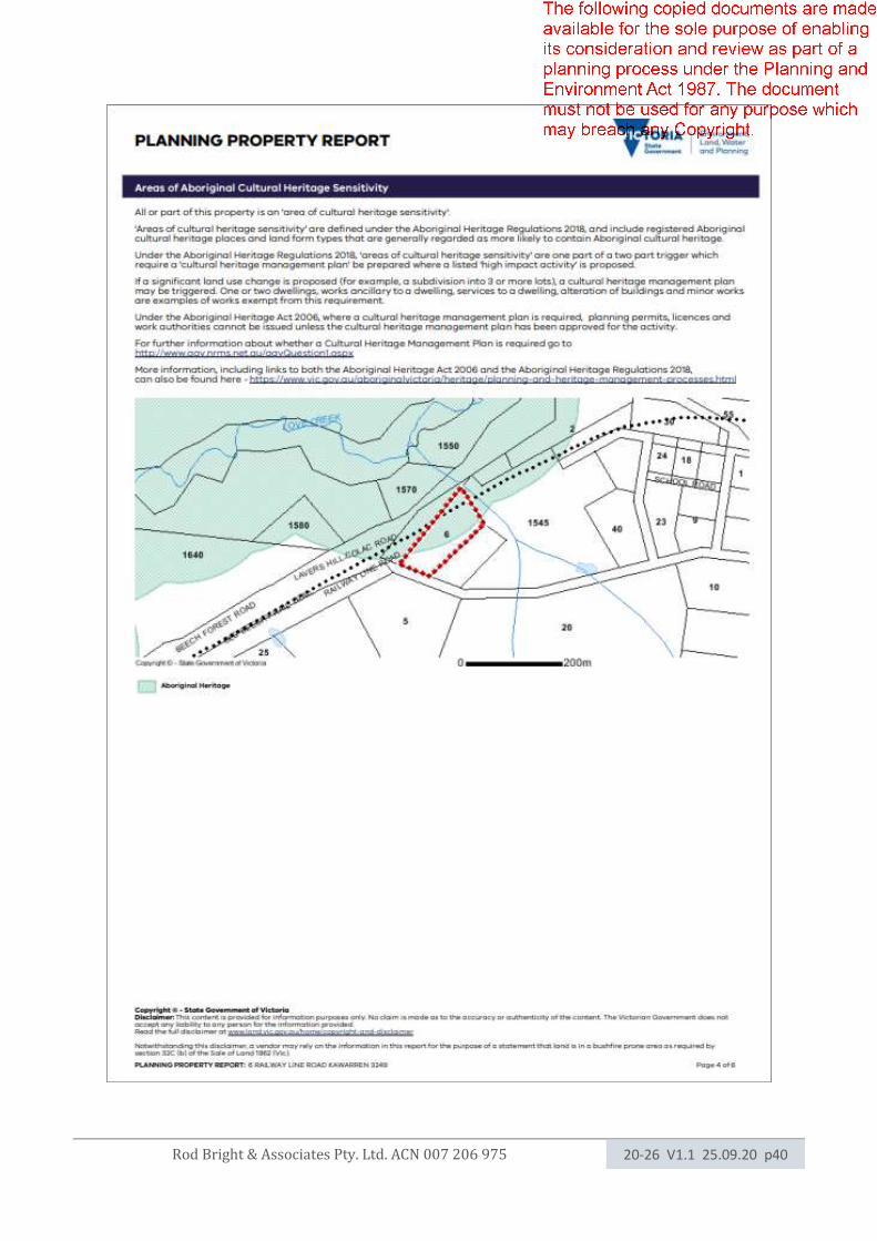
Rod Bright & Associates Pty. Ltd. ACN 007 206 975 20-26 V1.1 25.09.20 p40
Rod Bright & Associates Pty. Ltd. ACN 007 206 975 20-26 V1.1 25.09.20 p41
Rod Bright & Associates Pty. Ltd. ACN 007 206 975 20-26 V1.1 25.09.20 p42