bushfire risk unit - planning.tas.gov.au
TRANSCRIPT

State Headquarters Cnr Argyle and Melville Streets | GPO Box 1526 Hobart Tasmania 7001 | Phone (03) 6173 2740 Southern Region 1040 Cambridge Road, Cambridge Tasmania 7170 | Phone (03) 6166 5500 Northern Region 339 Hobart Road Youngtown Tasmania 7249 | Phone (03) 6777 3666 | Fax (03) 6345 5860 North West Region 15 Three Mile Line | PO Box 1015 Burnie Tasmania 7320 | Phone (03) 6477 7250 Fax (03) 6433 1551
Bushfire Risk Unit File No: AD3703 General Manager Devonport City Council [email protected] Dear Sir/Madam, DRAFT DEVONPORT LOCAL PROVISIONS SCHEDULE I write in relation to the draft Devonport Local Provisions Schedule (LPS). Please accept this as Tasmania Fire Service’s representation on this matter. This representation relates to two elements of the draft LPS:
1. The Bushfire-Prone Areas Overlay; and 2. DEV-S3.0 Devonport Reserved Residential Land Specific Area Plan.
Bushfire-Prone Areas Overlay
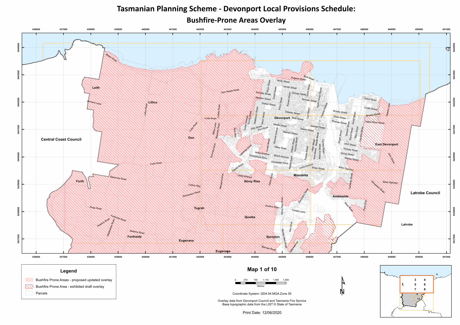
The draft Bushfire-Prone Areas Overlay was produced by Tasmania Fire Service in collaboration with Devonport City Council. The data used in the exhibited version of the draft Bushfire-Prone Areas Overlay was produced in March 2019. Since then, there have been some new developments that have proceeded and Tasmania Fire Service has received further advice on the management of some specific sites. Tasmania Fire Service and Council’s Project Officer have agreed that some minor refinements to the overlay are appropriate to avoid unnecessarily including properties that could now be mapped-out. It is therefore recommended that the overlay be modified prior to final approval. The enclosed maps show the advertised draft overlay and the proposed refined boundaries. A summary of the proposed updates is provided in Table 1. The proposed updates would remove total of 146 residential lots from the draft overlay.
Representation 16 - Tasmania Fire Service
Page 2 of 4
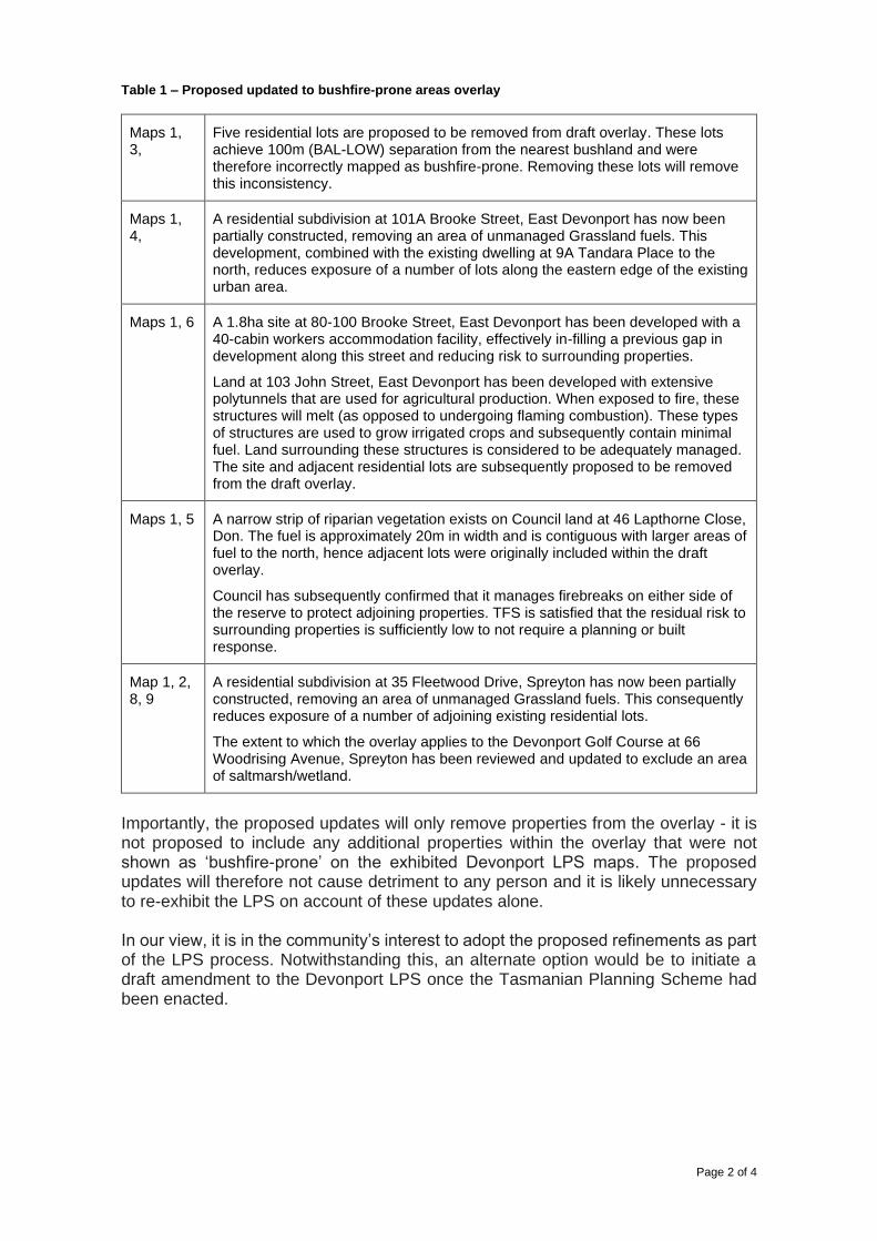
Table 1 – Proposed updated to bushfire-prone areas overlay
Maps 1, 3,
Five residential lots are proposed to be removed from draft overlay. These lots achieve 100m (BAL-LOW) separation from the nearest bushland and were therefore incorrectly mapped as bushfire-prone. Removing these lots will remove this inconsistency.
Maps 1, 4,
A residential subdivision at 101A Brooke Street, East Devonport has now been partially constructed, removing an area of unmanaged Grassland fuels. This development, combined with the existing dwelling at 9A Tandara Place to the north, reduces exposure of a number of lots along the eastern edge of the existing urban area.
Maps 1, 6 A 1.8ha site at 80-100 Brooke Street, East Devonport has been developed with a 40-cabin workers accommodation facility, effectively in-filling a previous gap in development along this street and reducing risk to surrounding properties.
Land at 103 John Street, East Devonport has been developed with extensive polytunnels that are used for agricultural production. When exposed to fire, these structures will melt (as opposed to undergoing flaming combustion). These types of structures are used to grow irrigated crops and subsequently contain minimal fuel. Land surrounding these structures is considered to be adequately managed. The site and adjacent residential lots are subsequently proposed to be removed from the draft overlay.
Maps 1, 5 A narrow strip of riparian vegetation exists on Council land at 46 Lapthorne Close, Don. The fuel is approximately 20m in width and is contiguous with larger areas of fuel to the north, hence adjacent lots were originally included within the draft overlay.
Council has subsequently confirmed that it manages firebreaks on either side of the reserve to protect adjoining properties. TFS is satisfied that the residual risk to surrounding properties is sufficiently low to not require a planning or built response.
Map 1, 2, 8, 9
A residential subdivision at 35 Fleetwood Drive, Spreyton has now been partially constructed, removing an area of unmanaged Grassland fuels. This consequently reduces exposure of a number of adjoining existing residential lots.
The extent to which the overlay applies to the Devonport Golf Course at 66 Woodrising Avenue, Spreyton has been reviewed and updated to exclude an area of saltmarsh/wetland.
Importantly, the proposed updates will only remove properties from the overlay - it is not proposed to include any additional properties within the overlay that were not shown as ‘bushfire-prone’ on the exhibited Devonport LPS maps. The proposed updates will therefore not cause detriment to any person and it is likely unnecessary to re-exhibit the LPS on account of these updates alone. In our view, it is in the community’s interest to adopt the proposed refinements as part of the LPS process. Notwithstanding this, an alternate option would be to initiate a draft amendment to the Devonport LPS once the Tasmanian Planning Scheme had been enacted.
Page 3 of 4
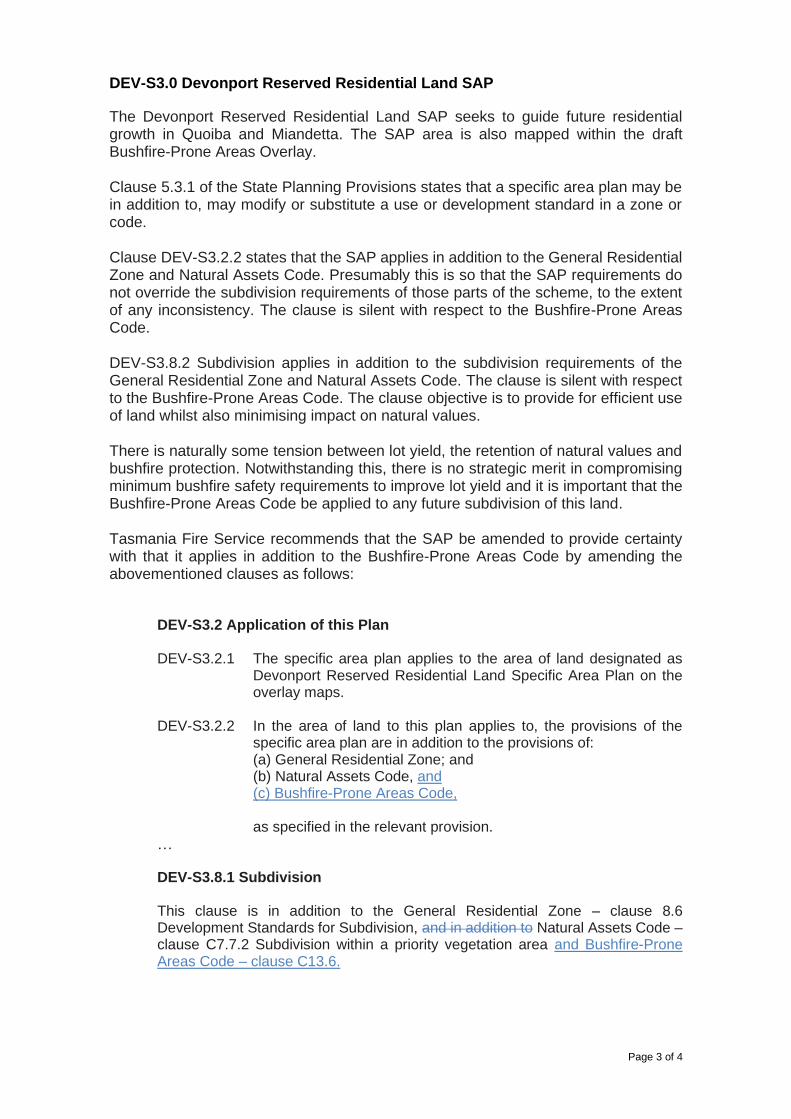
DEV-S3.0 Devonport Reserved Residential Land SAP
The Devonport Reserved Residential Land SAP seeks to guide future residential growth in Quoiba and Miandetta. The SAP area is also mapped within the draft Bushfire-Prone Areas Overlay. Clause 5.3.1 of the State Planning Provisions states that a specific area plan may be in addition to, may modify or substitute a use or development standard in a zone or code. Clause DEV-S3.2.2 states that the SAP applies in addition to the General Residential Zone and Natural Assets Code. Presumably this is so that the SAP requirements do not override the subdivision requirements of those parts of the scheme, to the extent of any inconsistency. The clause is silent with respect to the Bushfire-Prone Areas Code. DEV-S3.8.2 Subdivision applies in addition to the subdivision requirements of the General Residential Zone and Natural Assets Code. The clause is silent with respect to the Bushfire-Prone Areas Code. The clause objective is to provide for efficient use of land whilst also minimising impact on natural values. There is naturally some tension between lot yield, the retention of natural values and bushfire protection. Notwithstanding this, there is no strategic merit in compromising minimum bushfire safety requirements to improve lot yield and it is important that the Bushfire-Prone Areas Code be applied to any future subdivision of this land. Tasmania Fire Service recommends that the SAP be amended to provide certainty with that it applies in addition to the Bushfire-Prone Areas Code by amending the abovementioned clauses as follows:
DEV-S3.2 Application of this Plan DEV-S3.2.1 The specific area plan applies to the area of land designated as
Devonport Reserved Residential Land Specific Area Plan on the overlay maps.
DEV-S3.2.2 In the area of land to this plan applies to, the provisions of the
specific area plan are in addition to the provisions of: (a) General Residential Zone; and (b) Natural Assets Code, and (c) Bushfire-Prone Areas Code, as specified in the relevant provision.
…
DEV-S3.8.1 Subdivision This clause is in addition to the General Residential Zone – clause 8.6 Development Standards for Subdivision, and in addition to Natural Assets Code – clause C7.7.2 Subdivision within a priority vegetation area and Bushfire-Prone Areas Code – clause C13.6.

Page 4 of 4
If Tasmania Fire Service can provide any clarification or further information in relation to this submission, please contact me at [email protected]. Yours faithfully,
Tom O’Connor PLANNING & ASSESSMENT OFFICER 12 June 2020 Cc
Forth
Don
Leith
Devonport
Latrobe
East Devonport
Lillico
Tugrah
Forthside
Quoiba
Spreyton
Stony RiseMiandetta
Ambleside
Eugenana
Eugenana
Bass Highway
Forth Road
Lillico
Roa
d
Tugrah Road
River Road
Best Street
Forthside Road
Cutts Road
Brooke Street
Tarle
ton St
reet
Torquay Road
Don Road
John Street
Stony
Rise
Roa
d
Devon
port R
oad
Parker Street
Winspears Road
Sorel
l Stre
et
Durkins Road
Madden Street
Rona
ld Str
eet
Wave
rley R
oad
Mary
Stree
t
James Street
Bellamy Road
Watki
nson
Stree
t
Tasman StreetFormby Road
Don Heads Road
Hiller
Stree
t
Love
tt Stre
et
Bluff Road
Forbe
s Stre
et
North Street
Steele Street
Wrigh
t Stre
et
Thomas Street
Midd
le Ro
adWi
lliam
Stree
t
Victor
ia Pa
rade
Gunn
Stree
t
Valley Road
Stewart Street
George Street
Bay D
rive
Wenv
oe St
reet
Kings Road
Lyons Avenue
Surre
y Stre
et
Morris Avenue
Mersey Main Road
Carol
ine St
reet
Park
Drive
Triton Road
North
Fento
n Stre
et
Lodd
er Ro
ad
Drew Street
Hopkins Road
Leary Avenue
Upper Drew Street
Percy
Stree
t
Macfi
e Stre
et
Lawren
ce Drive
Jiloa Way
Webb
erley
s Roa
dOldaker Street
York
Stree
t
Harris
Roa
d
Milto
n Lan
e
Shaw Street
Jarmans Lane
Donv
ista D
rive
Beach Road
Bishops Road
Chichester Drive
Turners Lane
Marine Street
Mang
ana D
rive
Eugene Street
Young Street
Richardson Road
Leila A
venue
Arden Avenue
Badcocks Road
Coraki Street
Nixon
Stree
t
Victor
ia Str
eet
Teatr
ee La
ne
St Andrews Drive
Boron
ia Av
enue
David
Stree
t
Ellis Street
Collins Way
Came
ray St
reet
Nicholls Street
Curr S
treet
Tuck
er Av
enue
Nicholls Street
Cutts Road
Nixon
Stree
t
Brooke Street
Steele Street
Bass Highway
John Street
David
Stree
t
Latrobe Council
Central Coast Council
436000
436000
437000
437000
438000
438000
439000
439000
440000
440000
441000
441000
442000
442000
443000
443000
444000
444000
445000
445000
446000
446000
447000
447000
448000
448000
449000
449000
450000
450000
451000
451000
5437
000
5437
000
5438
000
5438
000
5439
000
5439
000
5440
000
5440
000
5441
000
5441
000
5442
000
5442
000
5443
000
5443
000
5444
000
5444
000
LegendBushfire Prone Areas - proposed updated overlayBushfire Prone Area - exhibited draft overlayParcels
2
19
8
3 45 67
10¹
Map 1 of 10
Print Date: 12/06/2020
0 370 740 1,110 1,480 1,850
Metres
Coordinate System: GDA 94 MGA Zone 55Overlay data from Devonport Council and Tasmania Fire Service
Base topographic data from the LIST © State of Tasmania
Tasmanian Planning Scheme - Devonport Local Provisions Schedule:Bushfire-Prone Areas Overlay

Latrobe
Melrose
Forthside
Spreyton
Forth
Paloona
Acacia Hills
Lower Barrington
Aberdeen
Eugenana
South Spreyton
Tugrah Quoiba
Melro
se R
oad
Paloo
na R
oad
Buster R
oad
Sheff
ield R
oad
Kelcey T
ier Road
Bella
my R
oad
Forth
side R
oad
Perrys Road
Wilmot Road
Mersey Main Road
Jowe
tts La
ne
Meads Road
Clayto
n Drive
Ellice Hill Drive
Dunc
ans R
oad
Woodrisi
ng Ave
nue
Bobwhite Drive
Morris Road
Layc
ock R
oad
Loone Lane
Squibbs Road
Donwood Court Gibs
on C
ourt
Wilmot Road
Latrobe Council
Kentish Council
Central Coast Council
436000
436000
437000
437000
438000
438000
439000
439000
440000
440000
441000
441000
442000
442000
443000
443000
444000
444000
445000
445000
446000
446000
447000
447000
448000
448000
449000
449000
450000
450000
451000
451000
5430
000
5430
000
5431
000
5431
000
5432
000
5432
000
5433
000
5433
000
5434
000
5434
000
5435
000
5435
000
5436
000
5436
000
5437
000
5437
000
LegendBushfire Prone Areas - proposed updated overlayBushfire Prone Area - exhibited draft overlayParcels
2
19
8
3 45 67
10¹
Map 2 of 10
Print Date: 12/06/2020
0 370 740 1,110 1,480 1,850
Metres
Coordinate System: GDA 94 MGA Zone 55Overlay data from Devonport Council and Tasmania Fire Service
Base topographic data from the LIST © State of Tasmania
Tasmanian Planning Scheme - Devonport Local Provisions Schedule:Bushfire-Prone Areas Overlay

Don
Devonport
Lillico
Parker Street
Madden Street
Bass
High
way
James Street
Sorel
l Stre
et
Best Street
Rona
ld Str
eet
Wave
rley R
oad
Don Heads Road
Cutts Road
Coles Beach Road
North Street
George Street
Watki
nson
Stree
t
Lodd
er Ro
adBluff Road
Gunn
Stree
t
Percy
Stree
t
Willia
m Str
eet
Oldaker Street
Surre
y Stre
et
Eugene Street
Upper George Street Cleme
nts St
reet
Bluff A
ccess
Road
Chalmers Lane
Nicholls Street
Curr S
treet
The Lee
Nixon
Stree
t
Waniora Street
Dean
e Stre
et
Madden Crescent
Addison Street
Morgan Court
Carter Place
Holyman Street
Haines Place
Bishton Street
Maxfield Court
Victor
y Ave
nue
Barke
r Stre
et
Monash Court
Adela
ide St
reet
Marga
ret St
reet
Kemp
ling S
treet
Monta
gue S
treet
Lindsay Place
McCabe Avenue
Brinckman Court
Eugene Street West
Glen
Cou
rt
Sharon Court
Kilrush Court
Cromwell Crescent
Wins
ton Pl
ace
Carin
ga Pl
ace
Pengali Place
Eagli
ng Pl
ace
Jabez Drive
Payto
n Plac
eMa
ringa
Plac
e
Souta
r Stre
et
Suns
et Co
urt
Clare
Court
Warru
ga Pl
ace
Kuran
da C
lose
Gordo
n Plac
e
Frede
rick P
lace
Madd
en Pl
ace
Saunders Court
Charl
otte G
arden
s
Nixon
Stree
t
Gunn
Stree
t
Best Street
Parker Street
Gunn
Stree
t
Nicholls Street
Nixon
Stree
t
Willia
m Str
eet
Oldaker Street
James Street
Oldaker Street
George StreetNicholls Street
North Street
Percy
Stree
t
Oldaker Street
Percy
Stree
t
Willia
m Str
eet
Bass
High
way
Cutts
Roa
d
Nicholls Street
Nixon
Stree
t
442000
442000
443000
443000
444000
444000
445000
445000
446000
446000
5442
000
5442
000
5443
000
5443
000
LegendBushfire Prone Areas - proposed updated overlayBushfire Prone Area - exhibited draft overlayParcels
2
19
8
3 45 67
10¹
Map 3 of 10
Print Date: 12/06/2020
0 100 200 300 400 500
Metres
Coordinate System: GDA 94 MGA Zone 55Overlay data from Devonport Council and Tasmania Fire Service
Base topographic data from the LIST © State of Tasmania
Tasmanian Planning Scheme - Devonport Local Provisions Schedule:Bushfire-Prone Areas Overlay

East Devonport
Devonport
Brooke Street
Bluff Road
Victoria Parade
James Street
Nicholls Street
Triton
Roa
d
North
Fento
n Stre
et
Drew Street
George Street
Tarle
ton St
reet
Oldaker Street
North
Caro
line S
treet
Parker Street
Gunn
Stree
t
Coraki Street
North Street
Teatr
ee La
ne
Cleme
nts St
reet
Lower Madden Street
Bluff A
ccess
Road
Pardo
e Stre
et
Churc
h Stre
et
Neely Street
Melrose Street
Curr S
treet
Wrigh
t Stre
et
Whee
ler St
reet
Ramsay Street
Gwynne Street
Bass
Stree
t
Bovill
Stree
t
Gloucester Avenue
David
Stree
t
Walpo
le Pla
ce
Arthur Street
Iluka Avenue
Mary
Stree
t
Kilrush Court
Kiah P
lace
Tandara Place
Birala
Plac
e
Pardoe Esplanade
Elanora Place
Charl
otte G
arden
s
Oran
a Plac
e
Binda Place
Parker Street
North
Fento
n Stre
et Brooke Street
Gunn
Stree
t
Wrigh
t Stre
et
446000
446000
447000
447000
448000
448000
449000
449000
450000
450000
5442
000
5442
000
5443
000
5443
000
LegendBushfire Prone Areas - proposed updated overlayBushfire Prone Area - exhibited draft overlayParcels
2
19
8
3 45 67
10¹
Map 4 of 10
Print Date: 12/06/2020
0 100 200 300 400 500
Metres
Coordinate System: GDA 94 MGA Zone 55Overlay data from Devonport Council and Tasmania Fire Service
Base topographic data from the LIST © State of Tasmania
Tasmanian Planning Scheme - Devonport Local Provisions Schedule:Bushfire-Prone Areas Overlay

Don Devonport
Stony Rise
MiandettaTugrah
Bass Highway
Best Street
Don Road
Forth Road
Tasman Street
Hiller
Stree
t
Love
tt Stre
et
Cutts Road
Forbe
s Stre
et
Willia
m Str
eet
Gunn
Stree
t
Valley Road
Waverley Road
Morris Avenue
Midd
le Ro
ad
Steele Street
Surre
y Stre
et
Stewart Street
Sorel
l Stre
et
Lyons AvenueWa
tkins
on St
reet
Rundle Road
Croft Avenue
Percy
Stree
t
Rona
ld Str
eet
Lawrence Drive
Stony Rise Road
Jiloa Way
Frond
Plac
e
York
Stree
t
Charles Street
Milto
n Lan
e
Frien
d Stre
et
Donvi
sta Dr
ive
Gree
nway
Aven
ue
Chichester DriveHil
lcres
t Roa
d
Oldaker Street
Old Coast Road
Lapthorne Close
Tugrah Road
Arden Avenue
Maroong Lane
Fento
n Stre
etGeorg
iana S
treet Nix
on St
reet
Victor
ia Str
eet
Turton Street
Harvil Way
Elizabeth StreetSt Andrews Drive
Hilltop AvenueJarrod Court
Franklin Street
Tatia
na C
lose
Weemala Lane
Boron
ia Av
enue
Dana Drive
Ellis Street
Olive Court
Lodd
er Ro
ad
Smith Street
Ashburner Street
Washington Drive
Wylie
Stree
t
Archer Street
Harold Street
Willow Avenue
Churc
hill A
venu
e
McBride Street
Matthews Way
Henry Street
Hedstrom Drive
Chettle Street
Clarke
Stree
t
Gatenby Drive
Fordh
am D
rive
Linden Heights
Tuck
er Av
enue
Maple
Aven
ue
Sumb
erg St
reet
Barke
r Stre
et Curr S
treet
Wayn
e Stre
et
Holyman Street
Griffi
ths St
reet
Macoma Close
Ashg
rove S
treetRic
hards
on Dr
ive
Victor
y Ave
nue
Wise Court
Highv
iew C
resce
nt
Cocker Place
Somm
e Stre
et
Adela
ide St
reet
Berrig
an R
oad
Wirreecoo Avenue
Leary A
venue
Moore Lane
Broa
dhurs
t Ave
nue
Valkyrie Close
Kemp
ling S
treet
Birch
Stree
t
Raym
ond A
venu
e
Allison
Court
Nyora Court
Glen
Cou
rt
Howell Lane
Victor
Cou
rt
Sprin
gfield
Cou
rt
Gatty PlacePin
e Plac
e
Mann
ing C
resce
nt
Morse Place
Tasm
an Pl
ace
Dahlia Court
Berkeley Court
College Court
Little
r Cou
rt
Rowena Court
Payto
n Plac
e
Erica Place
Auror
a Plac
e
Violet Place
Anna Place
Brufo
rd Pla
ce
Waratah Court
Jeffri
es La
ne
Middle Road
Oldaker Street
Steele Street
Hillcr
est R
oad
Cutts Road
Bass Highway
Steele Street
Lawren
ce Drive
Best Street
Willia
m Str
eet
442000
442000
443000
443000
444000
444000
445000
445000
446000
446000
5440
000
5440
000
5441
000
5441
000
LegendBushfire Prone Areas - proposed updated overlayBushfire Prone Area - exhibited draft overlayParcels
2
19
8
3 45 67
10¹
Map 5 of 10
Print Date: 12/06/2020
0 100 200 300 400 500
Metres
Coordinate System: GDA 94 MGA Zone 55Overlay data from Devonport Council and Tasmania Fire Service
Base topographic data from the LIST © State of Tasmania
Tasmanian Planning Scheme - Devonport Local Provisions Schedule:Bushfire-Prone Areas Overlay

East Devonport
Devonport
Miandetta
Ambleside
Brooke Street
Torquay Road
John Street
Tarle
ton St
reet
Bass Highway
Mary
Stree
t
Formby Road
Hiller
Stree
t
Forbe
s Stre
et
Wrigh
t Stre
et
Thomas Street
Wenv
oe St
reet
Best Street
Carol
ine St
reet
Steele Street Murray Street
Stewart Street
Drew Street
Stephen Street
Lyons Avenue
Upper Drew Street
Elizabeth Street
Turton Street
Oldaker Street
Macfi
e Stre
et
Douglas Street
York
Stree
t
Ashburner Street
Weemala Lane
Shaw Street
Hilltop AvenueFranklin Street
Marine Street
Berrig
an R
oad
Rook
e Lan
e
Young Street
Churc
h Stre
et
Loane Avenue
Pardo
e Stre
et
Bovill
Stree
t
Fento
n Stre
et
Drak
e Stre
et
Bass
Stree
t
Whee
ler St
reet
David
Stree
t
Smith Street
Cann
ing D
rive
King Street
Archer Street
Harold Street
Norton Way
Henry Street
North
Caro
line S
treet
Parker Street
Victor
ia Pa
rade
Cros
s Stre
et
Hake
a Clos
e
Curr S
treet
Edwa
rd Str
eet
Rook
e Stre
et
Griffi
ths St
reet
Wise Court
Somm
e Stre
etMoore Lane
Cedar Court
Payne AvenueFin
layso
ns W
ay
Nathan Court
Lantana CourtMa
rvan P
lace
Illalangi Drive
Chelsea Court
Princess Place
Sycamore Place
Oak Cour
t
Carol Court
Esplanade
Murray Street
Brooke Street
Espla
nade
Carol
ine St
reet
David
Stree
t
Bass Highway
John Street
Wrigh
t Stre
et
Rook
e Stre
et
Latrobe Council
446000
446000
447000
447000
448000
448000
449000
449000
450000
450000
5440
000
5440
000
5441
000
5441
000
LegendBushfire Prone Areas - proposed updated overlayBushfire Prone Area - exhibited draft overlayParcels
2
19
8
3 45 67
10¹
Map 6 of 10
Print Date: 12/06/2020
0 100 200 300 400 500
Metres
Coordinate System: GDA 94 MGA Zone 55Overlay data from Devonport Council and Tasmania Fire Service
Base topographic data from the LIST © State of Tasmania
Tasmanian Planning Scheme - Devonport Local Provisions Schedule:Bushfire-Prone Areas Overlay

Quoiba
Tugrah
Stony Rise
Miandetta
Spreyton
Don
Spreyton
Tugrah Road
Stony
Rise
Roa
d
Durkins Road
Devon
port R
oad
Midd
le Ro
ad
Berrigan Road
Bay Drive
Forest Heights Drive
Leary Avenue
Wren
swoo
d Drive
Nielsens Road
Harris
Roa
d
McCall Terrace
Turners Lane
Mang
ana D
rive
Race
cours
e Roa
d
Beaumont Drive
Williams
Reser
voir R
oad Fri
end S
treet
Wattle Road
Saleyard Road
Olive Court
Mungala Crescent
Hedstrom Drive
Tip Road
Penambul Drive
Lyons Avenue
Gatenby Drive
Greenwood Lane
Wiena Crescent
Doric Court
Formby Grove
Merse
y Main
Roa
d
Moore Lane
Somm
e Stre
et
Allison
Court
Nyora Court
Ferguson Drive
Merseyside Street
Roberton Close
McLeod Avenue
Berkeley Court
442000
442000
443000
443000
444000
444000
445000
445000
446000
446000
5438
000
5438
000
5439
000
5439
000
LegendBushfire Prone Areas - proposed updated overlayBushfire Prone Area - exhibited draft overlayParcels
2
19
8
3 45 67
10¹
Map 7 of 10
Print Date: 12/06/2020
0 100 200 300 400 500
Metres
Coordinate System: GDA 94 MGA Zone 55Overlay data from Devonport Council and Tasmania Fire Service
Base topographic data from the LIST © State of Tasmania
Tasmanian Planning Scheme - Devonport Local Provisions Schedule:Bushfire-Prone Areas Overlay

Latrobe
East Devonport
Ambleside
Miandetta
Spreyton
Quoiba
Quoiba
Devonport
River
Road
Bass Highway
Winspears Road
Devon
port R
oad
Highfield Road
Park
Drive
Torquay Road
Berrig
an R
oad
Shaw Street
Skyline
Drive
Mungala Crescent
John Street
Autumn Drive
Bel-air Crescent
Beaumont Drive
Oakwood Drive
Came
ray St
reet
Tarleton Street
Bellevue Court
Formby RoadMoore Lane
Somm
e Stre
et
Ambleside Place
Enderly Court
Piping Lane
Bass Highway
Latrobe Council
446000
446000
447000
447000
448000
448000
449000
449000
450000
450000
5438
000
5438
000
5439
000
5439
000
LegendBushfire Prone Areas - proposed updated overlayBushfire Prone Area - exhibited draft overlayParcels
2
19
8
3 45 67
10¹
Map 8 of 10
Print Date: 12/06/2020
0 100 200 300 400 500
Metres
Coordinate System: GDA 94 MGA Zone 55Overlay data from Devonport Council and Tasmania Fire Service
Base topographic data from the LIST © State of Tasmania
Tasmanian Planning Scheme - Devonport Local Provisions Schedule:Bushfire-Prone Areas Overlay

Spreyton
Quoiba
Eugenana
Tugrah
Quoiba
Aberdeen
Kelcey T
ier Road
Mersey Main Road
Sheff
ield R
oad
Bay D
rive
Woodrisi
ng Ave
nue
Wren
swoo
d Drive
Layc
ock R
oad
Loone Lane
Ellice Hill D
rive
Bishops Road
Luck Street
Leila A
venueSq
uibbs
Roa
d
Tip Road
Fleetw
ood Dr
ive
Tedmon Street
Pilgrims RoadRedruth Court
Ronan Court
Blackwood Lane
Swilkin
Drive
Wattle Bank Close
Kerrie Court
Latrobe Council
443000
443000
444000
444000
445000
445000
446000
446000
447000
447000
5436
000
5436
000
5437
000
5437
000
LegendBushfire Prone Areas - proposed updated overlayBushfire Prone Area - exhibited draft overlayParcels
2
19
8
3 45 67
10¹
Map 9 of 10
Print Date: 12/06/2020
0 100 200 300 400 500
Metres
Coordinate System: GDA 94 MGA Zone 55Overlay data from Devonport Council and Tasmania Fire Service
Base topographic data from the LIST © State of Tasmania
Tasmanian Planning Scheme - Devonport Local Provisions Schedule:Bushfire-Prone Areas Overlay

Spreyton
Aberdeen
Eugenana
South Spreyton
Melrose
Melrose Road
Sheff
ield R
oad
Jowe
tts La
ne
Clayton Drive
Bobwhite Drive
Buster Road
Ellice Hill Drive
Lakeside Road
Kelce
y Tier
Roa
d
Donwood Court
Gibs
on C
ourt
Hillwo
od Ri
se
Talbor Court
Tarleton Road
Nicholas Place
Pilgrims Road
Vons Way
Wattle Bank Close
Redruth Court
Christensen Street
Wattlepod Court
Latrobe Council
Kentish Council
442000
442000
443000
443000
444000
444000
445000
445000
446000
446000
5434
000
5434
000
5435
000
5435
000
LegendBushfire Prone Areas - proposed updated overlayBushfire Prone Area - exhibited draft overlayParcels
2
19
8
3 45 67
10¹
Map 10 of 10
Print Date: 12/06/2020
0 100 200 300 400 500
Metres
Coordinate System: GDA 94 MGA Zone 55Overlay data from Devonport Council and Tasmania Fire Service
Base topographic data from the LIST © State of Tasmania
Tasmanian Planning Scheme - Devonport Local Provisions Schedule:Bushfire-Prone Areas Overlay