business-strength geocoding - pitney bowes · business-strength geocoding ten ... latitude and...
TRANSCRIPT
W H I T E P A P E R :
Solutions for Enabling Lifetime Customer Relationships.
AMERICAS GEOCODING
Paul Barkin • Senior Product Manager, Americas Geocoding, Pitney Bowes Business Insight
Michael A. Schiff • Founder and Principal Analyst, MAS Strategies
Business-strength Geocoding
Ten requirements for more cost-efficient and effective business decisions
www.pbinsight.com
WHITE PAPER: AMERICAS GEOCODING
Business-strength Geocoding
Ten requirements for more cost-efficient and effective business decisions
2 ABSTRACT
ORGANIZATIONS MAKE CRITICAL BUSINESS DECISIONS BASED ON LOCATION DATA, DECISIONS THAT IMPACT VIRTUALLY EVERY ASPECT
OF AN ENTERPRISE FROM MARKET ANALYSIS AND RISK ASSESSMENT TO TARGETING, PORTFOLIO MANAGEMENT AND NETWORK
INVESTMENTS. BUT BEFORE YOU CAN ANALYZE, EXTRAPOLATE OR PROFIT FROM LOCATION DATA, YOU NEED TO FIRST ASSOCIATE
EACH RECORD WITH AN ACCURATE LATITUDE AND LONGITUDE COORDINATE—A PROCESS KNOWN AS GEOCODING.
GEOCODING IS COMPLEX, AND MISTAKES IN GEOCODE ASSIGNMENT CAN LEAD TO POOR BUSINESS DECISIONS THAT IMPACT RISK,
RELATIONSHIPS AND PROFITS. FORTUNATELY, EXPERTS HAVE IDENTIFIED TEN FACTORS THAT CAN HELP DETERMINE WHETHER AN
ORGANIZATION’S APPROACH TO GEOCODING MEASURES UP TO TODAY’S BEST PRACTICES ON ISSUES COVERING ACCURACY,
FLEXIBILITY, FUNCTIONALITY AND EXPERIENCE.
WITH TODAY’S TECHNOLOGY, ORGANIZATIONS CAN EVEN ACCESS WORLD-CLASS GEOCODING SOLUTIONS ON DEMAND THROUGH
CLOUD-BASED SOLUTIONS THAT OFFER ‘PAY AS YOU GO’ ACCESS WITH NO OVERHEAD EXPENSE. AS A RESULT, COMPANIES AND
GOVERNMENT AGENCIES HAVE FOUND THAT IT’S NOW EASIER AND MORE COST-EFFECTIVE TO GENERATE MORE PRECISE
INFORMATION—INCREASING CONFIDENCE IN YOUR DATA, AND YOUR DECISIONS.
ADDRESSES HELP THE UNITED STATES POSTAL SERVICE DELIVER MAIL. THEY DO NOT, HOWEVER, INDICATE IMPORTANT GEOGRAPHIC-RELATED ATTRIBUTES AND CHARACTERISTICS THAT CAN IMPACT RISK, CUSTOMER SATISFACTION AND PROFITS.
3Overview
Every business entity and government agency deals withaddress information.
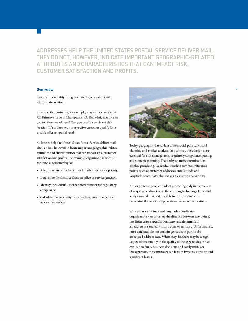
A prospective customer, for example, may request service at720 Primrose Lane in Chesapeake, VA. But what, exactly, canyou tell from an address? Can you provide service at thislocation? If so, does your prospective customer qualify for aspecific offer or special rate?
Addresses help the United States Postal Service deliver mail.They do not, however, indicate important geographic-relatedattributes and characteristics that can impact risk, customersatisfaction and profits. For example, organizations need anaccurate, automatic way to:
• Assign customers to territories for sales, service or pricing
• Determine the distance from an office or service junction
• Identify the Census Tract & parcel number for regulatory compliance
• Calculate the proximity to a coastline, hurricane path or nearest fire station
Today, geographic-based data drives social policy, networkplanning and market analysis. In business, these insights areessential for risk management, regulatory compliance, pricingand strategic planning. That’s why so many organizationsemploy geocoding. Geocodes translate common referencepoints, such as customer addresses, into latitude andlongitude coordinates that makes it easier to analyze data.
Although some people think of geocoding only in the contextof maps, geocoding is also the enabling technology for spatialanalysis—and makes it possible for organizations todetermine the relationship between two or more locations.
With accurate latitude and longitude coordinates,organizations can calculate the distance between two points,the distance to a specific boundary and determine ifan address is situated within a zone or territory. Unfortunately, most databases do not contain geocodes as part of the associated address data. When they do, there may be a high degree of uncertainty in the quality of those geocodes, which can lead to faulty business decisions and costly mistakes. On aggregate, these mistakes can lead to lawsuits, attrition and significant losses.

www.pbinsight.com
4
WHITE PAPER: AMERICAS GEOCODING
Business-strength Geocoding
Ten requirements for more cost-efficient and effective business decisions
Components of Business-strength Geocoding
Geocoding is very complex. There are several free or low-costconsumer-oriented applications that offer geocodingsolutions—but these tools were designed to support generalconsumer needs.
Business-strength geocoding, on the other hand, is meant forproblem solving. When organizations take a close look at therisks associated with a poor or inconsistent approach togeocoding, they soon find that accuracy, flexibility,functionality and experience can make all the difference.
Most business-oriented geocoding solutions consist of threeprimary components: address data standardization andvalidation, geocode determination and data enrichment.
• Just as the USPS cannot deliver a misaddressed envelope to its rightful destination, valid, well-defined addresses are important components of geocode accuracy. The USPS has established addressing conventions and guidelines governing punctuation and abbreviations, format, and address components for address standardization. The first step in augmenting an address with a geocode is to standardize and validate that address.
• When it comes to geocode determination, there will be times when it is not possible to deliver a geocode centered on a specific address. Business-strength tools will recognize this and apply consistent rules, automatically cascading to the next most-specific point of reference. In most cases, no geocode is better than a wrong geocode.
• Lastly, you will need an ability to append additional data sets, including demographics, purchasing preferences and lifestyle data. Plus, an ability to append spatial data derived from your analysis – such as territory assignment or flood zone determination.
The best business-strength tools will integrate all three ofthese components into a single solution, providing the mostaccurate results possible. In many cases, organizations cantake advantage of on demand and cloud-based solutions thatprovide “pay-as-you-go” access with no overhead expenses.
Challenges with Geocoding
Short of placing a global positioning system (GPS) at anaddress to determine its true longitude and latitude, there areseveral approaches to geocoding. These range from less precisemethods based on ZIP Codes all the way to parcel centroidlevel geocoding. Organizations interested in doing more withlocation-based data need to understand the challengesassociated with geocoding.
ZIP Code LimitationsZIP Codes are not necessarily stable over time. While a location’s latitude and longitude will never change, the USPS will often modify a location’s ZIP Code. Approximately 600,000 of the 40 million ZIP+4 Codes in the United States change each month. On top of that, many homes and businesses have been assigned addresses (e.g. for emergency 911 purposes) that are not recognized by the USPS for mail delivery.
Among the potential problems associated with ZIP Codegeocoding, is that it may span county or other municipalboundaries. Some areas, such as Carmel, California, only havemail delivery to post office boxes, not to homes. At the otherextreme are large office buildings in major metropolitan areas.These buildings may have multiple ZIP+4 codes, perhaps onefor each floor. Additionally, centralized mail delivery locations,which are used in many townhouse complexes, may have theirown ZIP+4 Codes and could be several hundred yards fromwhere the residents of the townhouse physically live.
Varying Degrees of AccuracyNot all geocodes are the same. Parcel Centroid geocodingplaces the coordinates at the center of the parcel associatedwith the physical street address (these are often referred to asa point-level or rooftop geocodes.) Street Segment Addressgeocoding is based on knowing the geocodes at nearbyintersections and then estimating the geocode of that addressby interpolation. For example, if a block runs from 101 to 201Main Street, then 149 Main Street would be approximatelyhalfway between the two end points. Some geocoding enginesgo further and improve upon standard street levelinterpolation by inserting parcel centroid data into theequation—resulting in a more accurate interpolation.
GEOCODING TOOLS SHOULD BE SOPHISTICATED ENOUGH TO ANALYZE MULTIPLE DATA SETS AND THEN COMPARE AN ADDRESS AGAINST ALL POTENTIAL GEOCODE CANDIDATES IN A SINGLE PASS.
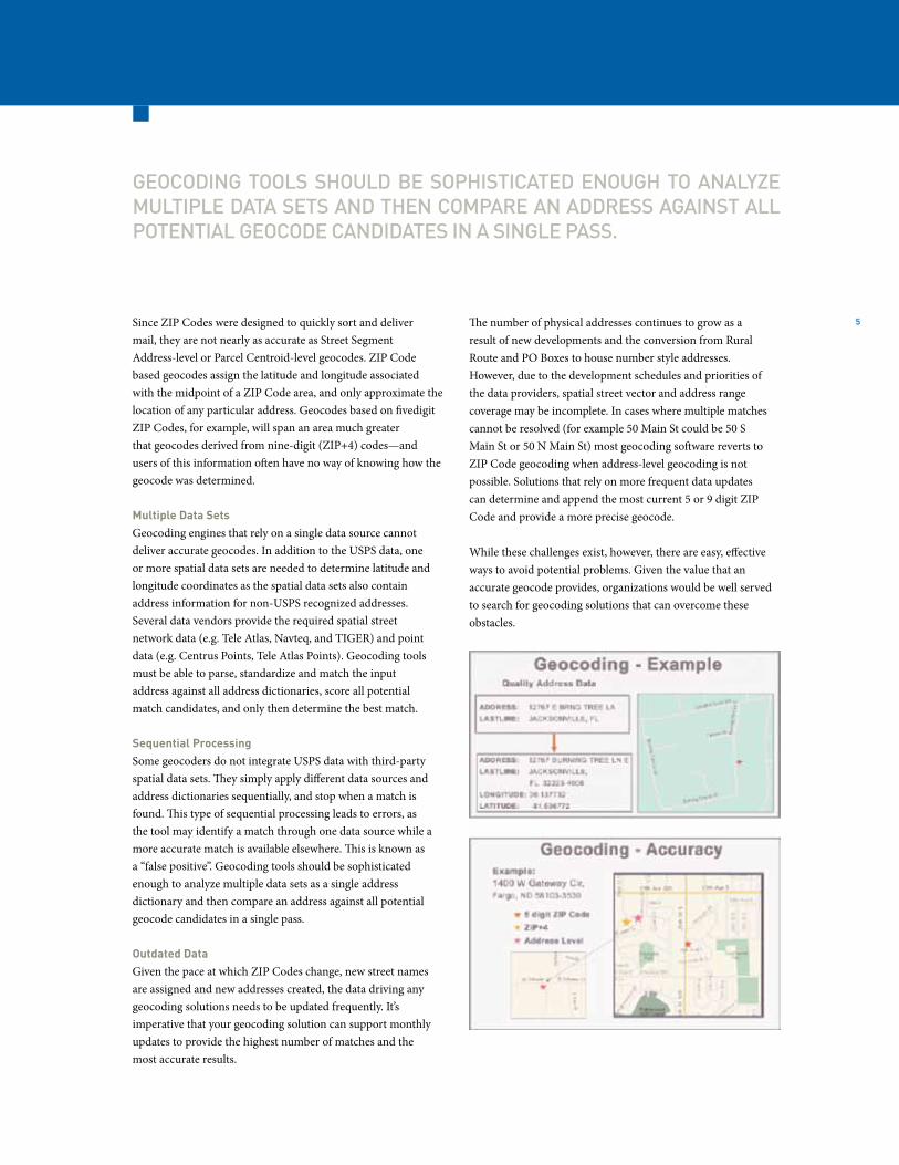
5Since ZIP Codes were designed to quickly sort and delivermail, they are not nearly as accurate as Street SegmentAddress-level or Parcel Centroid-level geocodes. ZIP Codebased geocodes assign the latitude and longitude associatedwith the midpoint of a ZIP Code area, and only approximate thelocation of any particular address. Geocodes based on fivedigitZIP Codes, for example, will span an area much greaterthat geocodes derived from nine-digit (ZIP+4) codes—and users of this information often have no way of knowing how the geocode was determined.
Multiple Data SetsGeocoding engines that rely on a single data source cannotdeliver accurate geocodes. In addition to the USPS data, oneor more spatial data sets are needed to determine latitude andlongitude coordinates as the spatial data sets also containaddress information for non-USPS recognized addresses.Several data vendors provide the required spatial streetnetwork data (e.g. Tele Atlas, Navteq, and TIGER) and pointdata (e.g. Centrus Points, Tele Atlas Points). Geocoding toolsmust be able to parse, standardize and match the inputaddress against all address dictionaries, score all potentialmatch candidates, and only then determine the best match.
Sequential ProcessingSome geocoders do not integrate USPS data with third-partyspatial data sets. They simply apply different data sources andaddress dictionaries sequentially, and stop when a match isfound. This type of sequential processing leads to errors, asthe tool may identify a match through one data source while amore accurate match is available elsewhere. This is known asa “false positive”. Geocoding tools should be sophisticatedenough to analyze multiple data sets as a single addressdictionary and then compare an address against all potentialgeocode candidates in a single pass.
Outdated DataGiven the pace at which ZIP Codes change, new street namesare assigned and new addresses created, the data driving anygeocoding solutions needs to be updated frequently. It’simperative that your geocoding solution can support monthlyupdates to provide the highest number of matches and themost accurate results.
The number of physical addresses continues to grow as aresult of new developments and the conversion from RuralRoute and PO Boxes to house number style addresses.However, due to the development schedules and priorities ofthe data providers, spatial street vector and address rangecoverage may be incomplete. In cases where multiple matchescannot be resolved (for example 50 Main St could be 50 SMain St or 50 N Main St) most geocoding software reverts toZIP Code geocoding when address-level geocoding is notpossible. Solutions that rely on more frequent data updatescan determine and append the most current 5 or 9 digit ZIPCode and provide a more precise geocode.
While these challenges exist, however, there are easy, effectiveways to avoid potential problems. Given the value that anaccurate geocode provides, organizations would be well servedto search for geocoding solutions that can overcome theseobstacles.
www.pbinsight.com
6
WHITE PAPER: AMERICAS GEOCODING
Business-strength Geocoding
Ten requirements for more cost-efficient and effective business decisions
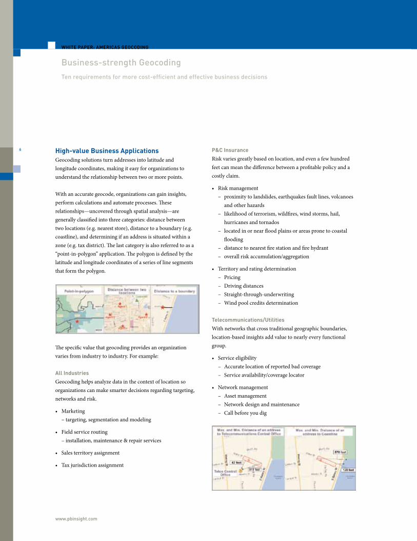
High-value Business ApplicationsGeocoding solutions turn addresses into latitude andlongitude coordinates, making it easy for organizations tounderstand the relationship between two or more points.
With an accurate geocode, organizations can gain insights,perform calculations and automate processes. Theserelationships—uncovered through spatial analysis—aregenerally classified into three categories: distance betweentwo locations (e.g. nearest store), distance to a boundary (e.g.coastline), and determining if an address is situated within azone (e.g. tax district). The last category is also referred to as a“point-in-polygon” application. The polygon is defined by thelatitude and longitude coordinates of a series of line segmentsthat form the polygon.
P&C Insurance
Risk varies greatly based on location, and even a few hundredfeet can mean the difference between a profitable policy and acostly claim.
• Risk management – proximity to landslides, earthquakes fault lines, volcanoes and other hazards – likelihood of terrorism, wildfires, wind storms, hail, hurricanes and tornados – located in or near flood plains or areas prone to coastal flooding – distance to nearest fire station and fire hydrant – overall risk accumulation/aggregation
• Territory and rating determination – Pricing – Driving distances – Straight-through-underwriting – Wind pool credits determination
Telecommunications/Utilities
With networks that cross traditional geographic boundaries,location-based insights add value to nearly every functionalgroup.
• Service eligibility – Accurate location of reported bad coverage – Service availability/coverage locator
• Network management – Asset management – Network design and maintenance – Call before you dig
The specific value that geocoding provides an organizationvaries from industry to industry. For example:
All Industries
Geocoding helps analyze data in the context of location soorganizations can make smarter decisions regarding targeting,networks and risk.
• Marketing – targeting, segmentation and modeling
• Field service routing – installation, maintenance & repair services
• Sales territory assignment
• Tax jurisdiction assignment
7
WITH AN ACCURATE GEOCODE, ORGANIZATIONS CAN GAIN INSIGHTS, PERFORM CALCULATIONS AND AUTOMATE PROCESSES.
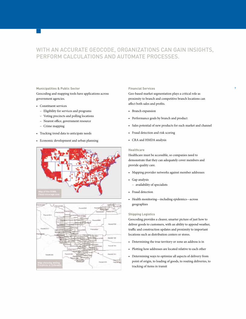
Municipalities & Public Sector
Geocoding and mapping tools have applications acrossgovernment agencies.
• Constituent services – Eligibility for services and programs – Voting precincts and polling locations – Nearest office, government resource – Crime mapping
• Tracking trend data to anticipate needs
• Economic development and urban planning
Financial Services
Geo-based market segmentation plays a critical role asproximity to branch and competitive branch locations canaffect both sales and profits.
• Branch expansion
• Performance goals by branch and product
• Sales potential of new products for each market and channel
• Fraud detection and risk scoring
• CRA and HMDA analysis
Healthcare
Healthcare must be accessible, so companies need todemonstrate that they can adequately cover members andprovide quality care.
• Mapping provider networks against member addresses
• Gap analysis – availability of specialists
• Fraud detection
• Health monitoring—including epidemics—across geographies
Shipping Logistics
Geocoding provides a clearer, smarter picture of just how todeliver goods to customers, with an ability to append weather,traffic and construction updates and proximity to importantlocations such as distribution centers or stores.
• Determining the true territory or zone an address is in
• Plotting how addresses are located relative to each other
• Determining ways to optimize all aspects of delivery from point of origin, to loading of goods, to routing deliveries, to tracking of items in transit
www.pbinsight.com
8
WHITE PAPER: AMERICAS GEOCODING
Business-strength Geocoding
Ten requirements for more cost-efficient and effective business decisions
Retail/Real Estate
Location impacts most every strategic decision facing organizations in the retail and real estate industries.
• Site selection
• Market expansion
• Managing store performance
• Trade area determination
The ten ‘must-haves’ for optimalgeocode results.
Given the wide-spread impact that geocoding can have on business decisions, organizations need to verify that their geocode technologies measure up to industry best practices. Ten factors in particular can determine how cost-efficient, effective and consistent your solution performs.
1. Integrated Address Quality
Accurate addresses are a prerequisite for accurate geocoding. Leading-edge solutions will offer the ability to cleanse data, standardize addresses and validate that source addresses are correct before applying geocodes.
While some geocoding vendors have partnerships with third-party name and address data quality vendors, it is more effective when these capabilities are integrated in one platform. This way you can standardize and correct address information in a single pass using multiple parsing and matching algorithms— giving you the ability to potentially resolve and standardize addresses a stand-alone algorithm might have rejected.
Having to conduct two or more separate passes (against multiple data sets) will also slow down data processing and potentially introduce erroneous matches and geocodes.
2. USPS-Certification
The USPS has developed rigorous standards and testing through CASS (Coding Accuracy and Support System) to ensure that vendor software can cleanse, standardize, and match common
address entry and formatting errors—and then accurately return the correct address, 9 digit ZIP Code, and other postal attributes. CASS-certified solutions also provide for Delivery Point Validation (DPV™) and Locatable Address Conversion System (LACS), other USPS technologies that help validate the accuracy of address information down to the physical delivery point.
• Previously, address-matching software could only validate that an address fell within the low-to high address range for the named street. By incorporating DPV, leading geocoding solutions can resolve multiple matches and determine if the actual address exists. DPV is also useful to identify if a location is vacant and can identify commercial mail receiving agencies (CMRAs) and private mail boxes.
• LACS converts rural addresses to city-style addressees. For example, an address like RR 1 Box 32 might be converted to a street-style address like 141 Morrison Ave. LACS also links your geocode engine to USPS updates when existing city-style addresses are renamed or renumber, or when a new delivery address is established.
3. Beyond USPS Data Sets
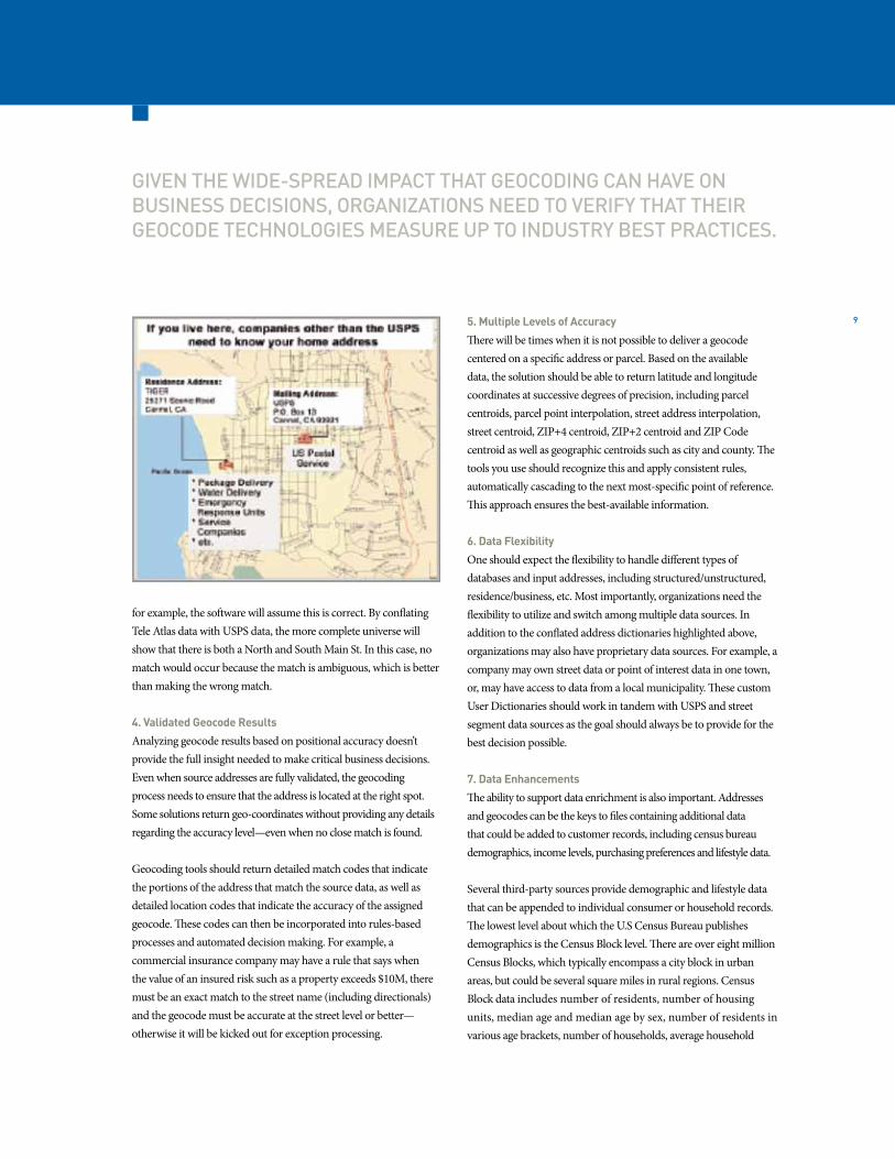
USPS data by itself, however, is not enough. It is vital that your geocoding solution can standardize and validate addresses against data sets that combine the most current USPS and non-USPS address data in a single, standardized address dictionary.
There are millions of households, for example, that receive mail at a Post Office Box; so the Smith Family may receive mail at PO Box 1934 even though their actual physical location is 31 Elm Street. The USPS will have no record of Elm Street in its database, even though it exists in street segment databases, such as Tele Atlas.
By combining information from the USPS with a street segment database, one benefits from a more complete universe of address data that provides more accurate matches. This process is known as conflation. Since any address verification and/or geocoding technology requires “fuzzy” matching – realizing the input addresses are not always perfect – this can lead to “false positives.” If 123Main St is entered and the USPS file only shows a South Main Street,
9
GIVEN THE WIDE-SPREAD IMPACT THAT GEOCODING CAN HAVE ON BUSINESS DECISIONS, ORGANIZATIONS NEED TO VERIFY THAT THEIR GEOCODE TECHNOLOGIES MEASURE UP TO INDUSTRY BEST PRACTICES.
for example, the software will assume this is correct. By conflating Tele Atlas data with USPS data, the more complete universe will show that there is both a North and South Main St. In this case, no match would occur because the match is ambiguous, which is better than making the wrong match.
4. Validated Geocode Results
Analyzing geocode results based on positional accuracy doesn’t provide the full insight needed to make critical business decisions. Even when source addresses are fully validated, the geocoding process needs to ensure that the address is located at the right spot. Some solutions return geo-coordinates without providing any details regarding the accuracy level—even when no close match is found.
Geocoding tools should return detailed match codes that indicate the portions of the address that match the source data, as well as detailed location codes that indicate the accuracy of the assigned geocode. These codes can then be incorporated into rules-based processes and automated decision making. For example, a commercial insurance company may have a rule that says when the value of an insured risk such as a property exceeds $10M, there must be an exact match to the street name (including directionals)and the geocode must be accurate at the street level or better—otherwise it will be kicked out for exception processing.
5. Multiple Levels of Accuracy
There will be times when it is not possible to deliver a geocode centered on a specific address or parcel. Based on the available data, the solution should be able to return latitude and longitude coordinates at successive degrees of precision, including parcel centroids, parcel point interpolation, street address interpolation, street centroid, ZIP+4 centroid, ZIP+2 centroid and ZIP Code centroid as well as geographic centroids such as city and county. Thetools you use should recognize this and apply consistent rules, automatically cascading to the next most-specific point of reference. This approach ensures the best-available information.
6. Data Flexibility
One should expect the flexibility to handle different types ofdatabases and input addresses, including structured/unstructured, residence/business, etc. Most importantly, organizations need the flexibility to utilize and switch among multiple data sources. In addition to the conflated address dictionaries highlighted above,organizations may also have proprietary data sources. For example, a company may own street data or point of interest data in one town, or, may have access to data from a local municipality. These custom User Dictionaries should work in tandem with USPS and street segment data sources as the goal should always be to provide for the best decision possible.
7. Data Enhancements
The ability to support data enrichment is also important. Addresses and geocodes can be the keys to files containing additional data that could be added to customer records, including census bureau demographics, income levels, purchasing preferences and lifestyle data.
Several third-party sources provide demographic and lifestyle data that can be appended to individual consumer or household records. The lowest level about which the U.S Census Bureau publishes demographics is the Census Block level. There are over eight million Census Blocks, which typically encompass a city block in urban areas, but could be several square miles in rural regions. Census Block data includes number of residents, number of housing units, median age and median age by sex, number of residents invarious age brackets, number of households, average household
www.pbinsight.com
10
WHITE PAPER: AMERICAS GEOCODING
Business-strength Geocoding
Ten requirements for more cost-efficient and effective business decisions
size, number of households with children, median household income, family income, along with several other fields. Marketing organizations can incorporate this data into their spatial analysis in order to determine where to open new stores, conduct targeted mailing campaigns, or advertise products and services.
8. Geoconfidence
As each geocoding technique is subject to varying degrees of precision, best-in-class geocoding solutions not only return the latitude and longitude, they also measure the degree of confidence in the results and the maximum possible error.
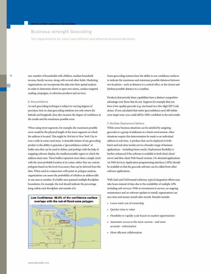
When using street segments, for example, the maximum possible error would be the physical length of the street segment on which the address is located. This might be 264 feet in New York City to over a mile in some rural areas. A desirable feature of any geocoding product is the ability to generate a “geoconfidence surface” or buffer area that can be used to define, and perhaps with the help of mapping software display, the smallest possible region in which theaddress must exist. These buffers represent more than a simple circle with the most probable location at its center, rather they are custom polygons based on the level of accuracy that can be derived from the data. When used in conjunction with point-in-polygon analysis,organizations can assess the probability of whether an address falls in one area or another. If a buffer area spanned multiple floodplain boundaries, for example, the tool should indicate the percentage lying within each floodplain and outside of it.
Some geocoding systems have the ability to use confidence surfaces to indicate the maximum and minimum possible distances between two locations—such as distance to a central office, or the closest and furthest possible distance to a coastline.
Products that provide these capabilities have a distinct competitive advantage over those that do not. Suppose for example that you have a low-quality geocode (e.g. one based on a five-digit ZIP Code alone). If you calculated that entire ‘geoconfidence area’ fell within your target zone, you could still be 100% confident in the end results.
9. Multiple Deployment Options
While some business situations can be satisfied by assigninggeocodes to a group of addresses in a batch environment, other situations require this determination be made to an individual address in real-time. A product that can be deployed in both batch and real-time modes serves a broader range of business applications—including future needs. Deployment flexibility is further enhanced if the software is available in both thick client/server and thin-client Web-based versions. On-demand applications via Web Services Application programming interfaces (APIs) shouldbe available so that the geocode software can be called from other software applications.
With SaaS and OnDemand solutions, typical integration efforts may take hours instead of days due to the availability of multiple APIs including web services. With no investment in servers, no ongoing maintenance and no software updates to install, organizations can save time and money month after month. Benefits include:
• Lower total cost of ownership
• Quicker time to value
• Flexibility to rapidly scale based on market opportunities
• Automatic access to the most current—and most accurate—information
• More efficient collaboration
11
X
10. Experienced, One-stop Service
While simple in concept, geocoding applications can have subtleties that are not obvious to those implementing them for the first time. Vendor expertise, including a track record of successful implementations across a variety of business cases, can prove invaluable both during the planning and implementation stages. Experienced vendors can often add value by suggesting the appropriate data augmentation databases and providing suggestions as to how other clients with similar issues have utilized geocoding technology. A vendor’s financial stability should also be examined indetermining future support and product stability and reliability.
Overall, solutions need to be simple to use and flexible enough to meet different business requirements. A single technology platform that matches up with your overall corporate objectives can help ensure that a consistent standard will be applied in every market. Likewise, maintaining one platform reduces cost of ownership andcan speed up system integration. A single interface also simplifies training and education, and makes it easier for your company to gain the skills and capabilities needed to achieve a competitive advantage.
Even if two vendors are using the same underlying geocoding database, match rates will vary due to differences in parsing and matching techniques. Conducting a benchmark designed to reflect your business requirements will provide valuable information in helping you select one technology over another.
ConclusionMore than 70% of all business records include a location component, so it is not surprising that location-based analysis is in such high demand nowadays. While a physical address is of paramount importance for postal delivery purposes, it does not tell you where that address is located relative to other locations, such as a sales territory, flood plain or specific tax district—or distance to the nearest office.
Spatial analysis serves as a basis for business decisions in marketing, operations and a wide variety of industries such as insurance, telecommunications and the public sector. But before you can
analyze, extrapolate or profit from location data, you need to associate each record with an accurate latitude and longitude coordinate—a process known as geocoding.
Geocoding can be complex, and mistakes in geocodeassignment can lead to poor business decisions that impact risk, relationships and profits. Organizations need to consider several factors when choosing a geocoding solution, including accuracy, flexibility, functionality and experience. Today’s leading enterprise geocoding tools combine address quality, multi-level geocoding and spatial analysis in a single solution that can apply the same standardized rules in every market—so you can act with confidence.
ABOUT PITNEY BOWES BUSINESS INSIGHT
Pitney Bowes Business Insight offers a unique combination of location and
communication intelligence software, data and services that can be used
throughout an organization. We combine our deep industry knowledge with our
strategic analysis offerings and apply our expertise to help you take action that
leads to better, more insightful decisions. You will get a more accurate view of your
customers, and integrate that intelligence into your daily business operations to
increase revenue, improve profitability and enhance operational efficiency. Call
800-327-8627 or visit www.pbinsight.com for more information.
ABOUT MAS STRATEGIES
MAS Strategies specializes in helping vendors market and position their business
intelligence and data warehousing products in today’s highly competitive market.
Typical engagements include SWOT analysis, market research, due diligence
support, white papers, public presentations, and helping organizations evaluate
tactical and strategic product and marketing decisions. MAS Strategies also assists
user organizations in their data warehouse procurement evaluations, needs
analysis, and project implementations. For more information about MAS Strategies,
visit its Web site at www.mas-strategies.com.
Every connection is a new opportunity™
© 2011 Pitney Bowes Software, Inc. All rights reserved.Pitney Bowes Business Insight is a division of Pitney Bowes Software Inc. The Pitney Bowes logo is a registered trademark of Pitney Bowes Inc. All other brand names and trademarks are the property of their respective owners.
00000 AM 1110
UNITED STATES
One Global View Troy, NY 12180
1.800.327.8627
[email protected] www.pbinsight.com
CANADA
26 Wellington Street East Suite 500 Toronto, ON M5E 1S2
1.800.268.3282
[email protected] www.pbinsight.ca
EUROPE/UNITED KINGDOM
Minton Place Victoria Street Windsor, Berkshire SL4 1EG
+44.800.840.0001
[email protected] www.pbinsight.co.uk
ASIA PACIFIC/AUSTRALIA
Level 7, 1 Elizabeth Plaza North Sydney NSW 2060
+61.2.9437.6255
[email protected] [email protected] www.pbinsight.com.au