california coastal trail san mateo county midcoast … coastal trail san mateo county midcoast...
TRANSCRIPT

California Coastal Trail San Mateo County Midcoast Pillar Point to Mirada Surf
Trails Team – Midcoast Parks and Recreation Committee
Final Report March 23, 2010
Table of Contents Introduction......................................................................................................................... 2 The Project: Pillar Point to Mirada Surf ............................................................................ 3
Pillar Point to Denniston Creek ...................................................................................... 4 Denniston Creek to Boat Launch Ramp ......................................................................... 8 Boat Launch Ramp to Mirada Surf............................................................................... 11
Appendix........................................................................................................................... 12

Introduction This report by the Trails Team of the Midcoast Parks & Recreation Committee (MPRC) focuses on the California Coastal Trail from Pillar Point south to the recently completed trail section at Mirada Surf. The report addresses:
• The route for the trail, including near and long term options • Considerations for creating an action plan for implementation.
The Midcoast California Coastal Trail will extend from Half Moon Bay to Devil’s Slide to occupy the current Highway 1 route after completion of the new tunnel.
The trail has been completed over much of the central shoreline of Half Moon Bay in projects taken on by California State Parks and the City of Half Moon Bay. The completed trail along Half Moon Bay is a consistently wide (10 – 12 feet) multi-use (pedestrian and bicycle) trail with many open ocean, bluff, and shoreline views. A distinctive feature of the trail through the remainder of the Midcoast will be a variety of trail styles and transitions through diverse terrains. Team Profile The Trails Team is a group of local volunteers from the Midcoast Parks and Recreation Committee, a Midcoast extension of the San Mateo County Parks Department, led by Parks Director Dave Holland and supported by his staff. It is anticipated that a non-profit Friends of the Midcoast California Coastal Trail will be formed to assist the project work through fund raising, publicity, work projects and addressing concerns that impact trail quality.
Midcoast Parks and Recreation Committee 2 Update: 3/23/10 Coastal Trail Team Printed: 4/7/10
Guidelines Important guidance comes from “Completing the California Coastal Trail” (CCCT) by the Coastal Conservancy and other relevant sources:
• Consistent with County and California trail standards, the trail will have a minimum four foot width with a variety of surfaces - graveled, paved, boardwalk, etc. (San Mateo County Trail Plan).
• The San Mateo County Trail Plan Design and Management Guidelines will be followed to ensure the improvements developed are consistent with County General Plan policies.
• To achieve timely and tangible results with the resources that are available, both interim and long-term alignments of the trail will be identified. (CCCT, p. 14)
• A primary objective is to keep pedestrian users close to the beach and on the west side of Highway 1. The trail will be braided in certain sections with separate options for different modes of travel. (CCCT, pp. 12-14)
• A flexible policy of supporting bicycle use and following the suggestions of CCCT for having good signage, shared access and encourage good motorist awareness will be followed (pp. 36-37).
• The diverse segments of the trail will make it difficult to provide quality opportunities for equestrians, but routing will be alert to possibilities (pp. 37-38).
• In this era of limited resources, the key point is to make the trail happen, even if it is not perfect. It is important to have a designated trail versus no trail at all. Signage on trail segments that may need more improvements in the future is considered a critical step, since it "puts down an anchor" and establishes that the trail exists. (Una Glass, Executive Director, Coastwalk California)
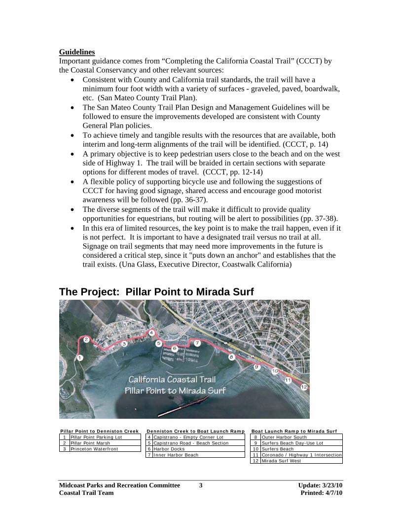
The Project: Pillar Point to Mirada Surf
Pillar Point to Denniston Creek Denniston Creek to Boat Launch Ramp Boat Launch Ramp to Mirada Surf1 Pillar Point Parking Lot 4 Capistrano - Empty Corner Lot 8 Outer Harbor South2 Pillar Point Marsh 5 Capistrano Road - Beach Section 9 Surfers Beach Day-Use Lot3 Princeton Waterfront 6 Harbor Docks 10 Surfers Beach
7 Inner Harbor Beach 11 Coronado / Highway 1 Intersection12 Mirada Surf West
Midcoast Parks and Recreation Committee 3 Update: 3/23/10 Coastal Trail Team Printed: 4/7/10

Pillar Point to Denniston Creek 1. Pillar Point Parking Lot is a small unimproved lot next to Pillar Point Marsh at the end of West Point Ave. where it enters the Air Force Tracking Station. It is the trailhead for the West Shoreline Access Trail which follows the edge of the marsh to the outer harbor beach, then follows the shoreline to the west breakwater and Mavericks beach. Across West Point Ave. from the parking lot is gated access to Pillar Point Bluff with informal trails leading to Ross’s Cove and the Jean Lauer section of the California Coastal Trail. Recommendations: Improve lot, signage, and upgrade to vault toilet 2. Pillar Point Marsh is divided into fresh and salt-water environments by an old earthen dam topped by the raised roadbed of West Point Ave. which is the only vehicle access to Pillar Point. West Point Ave. is narrow, with no shoulders, has a steep drop-off on both sides, and much of it is closely lined with thick marsh willows creating a long blind curve. It is a no-parking designated fire lane. Bikes use this route. Pedestrians have to walk in the road, hugging the edge of the pavement when cars come by. Alternate beach route between West Shoreline Access Trail and the harbor end of West Point Ave. is usually walkable, though monthly highest tides and storm surge enter and drain from the marsh cutting changing channels across the beach. Recommendations:
• Willows on the south side of West Point Ave. should be cut back at least 6 feet from the road edge to improve visibility. They will require regular maintenance.
• Create a separate pedestrian trail along the roadway. • Signage/map should indicate the alternate beach route.
Midcoast Parks and Recreation Committee 4 Update: 3/23/10 Coastal Trail Team Printed: 4/7/10

3. Princeton Waterfront Proposed trail route through Princeton is via Princeton Ave., Broadway, and Prospect to Denniston Creek. Princeton Ave. is 3 blocks long, parallels and is closest to the waterfront, with intermittent harbor views and potential beach access. Princeton Ave. has only local traffic, in contrast to other streets through Princeton which carry considerable through traffic. At the east end of Princeton Ave, a short jog north on Broadway connects the trail to Prospect Way which is a very busy street, being the sole southern outlet for Princeton, Pillar Ridge, and Seal Cove neighborhoods. These streets, between West Point Ave. and Denniston Creek, have no sidewalks or curbs, storm drainage is poor, and unpaved shoulders are often blocked by parked, stored, or abandoned vehicles, leaving bikes and even pedestrians in the street.
Midcoast Parks and Recreation Committee 5 Update: 3/23/10 Coastal Trail Team Printed: 4/7/10

There are four short unpaved road stubs connecting Princeton Ave. to the shoreline for views and possible beach access. From west to east:
• West Point Ave.: The grade change from road to beach is easy, but an intermittent seawater pond forms in a low area created by past storm erosion and subsequent barrier beach buildup. When the pond is present beach access depends on climbing over ice-plant-covered ledge or getting wet feet. The beach west of West Point is walkable even at high tide. Just east of West Point, at Romeo Pier, an extensive section of recent unpermitted riprap on the beach blocks passage even when the beach further east is still above the tide line.
• Vassar: 2002 Coastal Access Improvement Plan includes plans for ramp through riprap at Vassar.
• Columbia: Beach access is hindered by riprap. Improving access at this point would gain the most beach-walking benefit because the two blocks between West Point and Columbia are walkable except at high tide. Thus Coastal Trail walkers could take an alternate beach route between Pillar Point and Columbia except at each day’s highest tide.
• Broadway: 2002 Coastal Access Improvement Plan includes plans for stairs to beach at the mouth of Denniston Creek. There is a 20-foot-wide trail easement across the creek mouth and a 10-foot-wide trail easement along the east side of the creek to Prospect Way. The harbor bluff east of Columbia is mostly armored and the beach is underwater except at very low tides.
Midcoast Parks and Recreation Committee 6 Update: 3/23/10 Coastal Trail Team Printed: 4/7/10

Recommendations: • Coordinate with Department of Public Works on street improvements planned for
2011 to ensure adequate provision for CCT pedestrian and bicycle safety. Previous street improvements in Princeton have only repaved and added V-channel gutters, leaving pedestrians and bicycles in the gutter and street. Consider one-way traffic on Princeton to accommodate all users safely without losing parking space. Paving Vassar between Princeton and Harvard would be necessary for good circulation if Princeton Ave. were one way. Tree removal on Princeton at Broadway will be minimized to the extent practicable. Speed bumps or other traffic calming measures should be considered if necessary where increased trail use is proposed.
• Improve beach access at four shoreline street stubs, including landscaping and weed management. The most complete beach alternative along the Princeton shoreline would be created by improving access at Columbia.
• The Princeton waterfront needs a clear and accepted plan for dealing with erosion, construction at the shoreline, and illegal/ haphazard riprap, all of which impact public access and enjoyment of this coastal resource.
Midcoast Parks and Recreation Committee 7 Update: 3/23/10 Coastal Trail Team Printed: 4/7/10

Denniston Creek to Boat Launch Ramp 4. Denniston Creek & Capistrano/Prospect corner lot Near-term, route the trail along existing sidewalk at street edge of empty corner lot. Prospect sidewalk is 5-1/2 ft wide east of the creek. Capistrano sidewalk is 7 ft wide with jogs around parking cutouts. An existing wide informal trail cuts diagonally across the empty lot and is a popular bike and pedestrian route avoiding narrow and busy streets. Another informal trail follows the creek and harbor edge of the lot. All these routes converge at the 5-1/2 ft wide bottleneck at Denniston Creek culvert and Prospect Way. Parking and trail confusion exists on Prospect Recommendations:
• On Prospect Way at the creek culvert, alleviate
bottleneck by widening sidewalk and reducing parking cutout . Paint curb red on either side of parking cutout.
• On Prospect Way west of creek,
create uniform sidewalk or multi-use trail extending to Broadway, separated from street and parking.
• If development of the lot is proposed, seek to obtain a multi-use trail easement. A 10 ft. wide trail easement exists along the creek, but none at harbor edge. A 20 ft. wide trail easement exists across the mouth of Denniston Creek.
• If stairs to beach are built at foot of Broadway, consider constructing stairs to
beach at junction of creek trail easements.
• Long term: If appropriate trail easements are obtained, consider feasibility of bridge across mouth of Denniston Creek connecting foot of Broadway to corner lot.
Midcoast Parks and Recreation Committee 8 Update: 3/23/10 Coastal Trail Team Printed: 4/7/10

5. Capistrano Road at Beach section The sidewalk is 5 ft wide at this section & often congested with restaurant patrons. Capistrano narrows at this section with no parking allowed. It is a designated bike route but bicyclists often use the sidewalk due to busy, narrow street with no bike lanes. At the south end of this trail section there is no ramp at the curb for bikes entering/exiting the harbor. Sometimes delivery trucks park in front of the restaurant blocking the entire lane.
The beach at this section is walkable except at the highest tides but its use as an alternate route is limited by riprap, particularly difficult at the north end. An existing small complex of planters, stairs, & sidewalks at the north end above the beach leads naturally to the spot for stairs to the beach. Recommendations:
• Improve access to beach at both ends. • Consider feasibility of bypassing this section with a boardwalk, attaching to the
seawall at the roadway (to minimize beach impact), then bending behind Barbara’s Fishtrap and across to the harbor sidewalk. This concept would be dependent on obtaining an easement for the north terminus at Capistrano corner lot.
Midcoast Parks and Recreation Committee 9 Update: 3/23/10 Coastal Trail Team Printed: 4/7/10

6. Harbor Docks Use existing waterfront sidewalks. 7. Inner Harbor Beach The segment along the south edge of the harbor dock has only a narrow informal trail between a small parking lot & the riprap waterfront. Currently people are either using the narrow dirt trail or the parking lot pavement.
An informal trail cuts across the open area inland of the kayak business and joins the completed multi-use trail along the road to the boat launch ramp. The Harbor District may have long-term plans to develop this open flat area by dredging and construction of new dock, parking lot, and restroom. The area was also proposed as possible site for a Community Center.
Recommendations:
• Consult with the Harbor District about the possibility of eliminating up to 8 parallel parking spaces along the outside edge of the lot to allow for the multi-use Coastal Trail there. Alternatively, could a formal pedestrian trail be created via the existing narrow informal trail route, and bikes via the parking lot?
• Provide a firmer multi-use surface for the soft sand areas of the informal trail connection behind the kayak stand.
Midcoast Parks and Recreation Committee 10 Update: 3/23/10 Coastal Trail Team Printed: 4/7/10

Boat Launch Ramp to Mirada Surf 8. Outer Harbor South Trail is complete except for formal designation and signage. 9. Surfers Beach Day-Use Lot Multi-use trail around the outer edge is complete. Lot has outdoor shower. Recommendations:
• Needs trash receptacles that won’t blow over. • Needs restroom.
10. Surfers Beach This trail along the west edge of Hwy 1 is severely threatened by erosion. Recent re-armoring and trail paving along the northern section has gained a temporary reprieve. At the mid portion the bluff is so eroded there is inadequate space for the trail. The southern unpaved section has overgrown willows severely crowding the trail, and utility covers above grade creating trip hazards. Beach access is down the steep slippery grade where the bluff is most eroded. Beach access via an informal trail on the beach side of the ravine can only be accessed from Coronado and has the drawback of routing people close to the crumbling bluff edge. The beach is popular and gets heavy use in summer and on weekends. Recommendations:
• Ultimately both trail and highway may need to move inland. In the meantime it seems worthwhile to make interim repairs for the trail and beach access.
• Explore short-term methods to bridge narrow eroded section of the trail, and improve beach access. Relatively inexpensive and easily replaced improvements would be prudent in this location.
• On-going willow pruning program is needed to keep the trail clear. Prune willows off level bluff area needed for trail, but leave willows on slopes to help hold soil. Remove pampas grass, an invasive weed.
• On the southern section raise grade to level of utility covers.
Midcoast Parks and Recreation Committee 11 Update: 3/23/10 Coastal Trail Team Printed: 4/7/10

11. Coronado/ Hwy 1 intersection
• County/ Caltrans/ HMB agree on plan for old road remnants/ barriers, and smooth trail connection.
• Possible rest room site. • Improve Hwy 1 crossing. • Need trash receptacles that won’t blow over.
12. Mirada Surf West
• Trail construction completed summer 2009 • Possible rest room site at south end near bridge • Provide public parking at south end • Consider one-way traffic on Magellan/Mirada Rd. to better accommodate CCT.
Appendix • Reports from the study phase of this project • San Mateo County Harbor District comments • Comments from public meeting 1/26/10
Midcoast Parks and Recreation Committee 12 Update: 3/23/10 Coastal Trail Team Printed: 4/7/10