carlton county land use and cover - mn it services
TRANSCRIPT
41 0 1 2 3 4 Miles
1 0 1 2 3 4 5 Kilometers
Liability StatementThe Land Management Information Center (LMIC) does not warrant the results you may obtain by using this map. This map is provided 'as is' without express or implied warranties, including warranties of merchantability and fitness. In no event will LMIC be liable for any consequential, incidental or special damages, including any lost profits or lost savings, even if a LMIC representative has been advised of the possibility of such damages or any other claim by any third party.
This map was prepared in April, 1999. Both the map and the data used to create it are available from the Land Management Information Center at Minnesota Planning.
You may also view a generalized, interactive land use map of Minnesota, along withdetailed information about land use data at:
Distribution Information
Land Management Information Center658 Cedar StreetCentennial Building, Room 330St. Paul, MN 55155Phone: (651) 296-1211FAX: (651) 296-1212email: [email protected]
For further assistance, or to order copies of this map, contact:
Source: The Land Management Information Center (LMIC)
Land Use Data Sources*Bemidji State University - Department of GeographyBeltrami and Clearwater CountySoil and Water Conservation DistrictsSource Photography Date: 1986Manitoba Remote Sensing CentreSource Imagery Dates: 1991-1996Rochester - Olmsted Planning DepartmentSource Photography Date: 1992The International CoalitionSource Photography Dates: 1988-1990Metropolitan CouncilSource Photography Date: 1990
* Land use classifications vary slightly between data sources.
Department of Natural ResourcesDivision of Forestry - Resource AssessmentSource Imagery Dates: 1992, 1993 and 1996
Mapped County Location
Linnett Geosystems, WinnipegThe Manitoba Remote Sensing Centre, WinnipegMinnesota Department of Natural ResourcesUniversity of Minnesota - Department of Forest ResourcesWidseth, Smith and Nolting
Credits and AcknowledgementsData collection and interpretation supported by the Minnesota Future Resources Fund as recommended by the Legislative Commission on Minnesota Resources (LCMR).
The following groups also participated over an extended period:
Urban/IndustrialFarmsteads and Rural ResidencesOther Rural DevelopmentsCultivated LandGrasslandShrubby GrasslandRegeneration/Young ForestMixed ForestDeciduous ForestConiferous ForestWetlands: BogsWetlands: Marsh and FensWaterGravel Pits and Open MinesBare Rock
Land Use
R25WTownshipRange & Direction
T34
SectionTownship & RangeCounty Boundary
4Public Land SurveyState Boundary
Municipal Boundary
Interstate HighwayU.S. Trunk HighwayState Trunk HighwayCounty State-Aid Highway (CSAH)
',
Æ"
#S
(/
3Highways
COUNTY SEATOther Cities
Cities2
Data Sources4 Produced by the Minnesota Land Management Information Center from U.S. Geological Survey (USGS), 1:100,000 scale, 30'x60' quadrangle maps published between 1977 and 1986.
1 Manitoba Remote Sensing Centre, Source Imagery Dates: 1991-19962 TIGER/Line Census Files, U.S. Bureau of the Census, 1995.3 Minnesota Department of Transportation, 1997-98.
MAP FEATURES
R17WR20W R18W R16WR21W R19W
T46
T47
T48
T49
http://mapserver.lmic.state.mn.us/landuse
Map Projection: UTM, Extended Zone 15NAD83Datum:
1
6123 54
7
6
6
2
7
5
7
4 3 5
6
36
6
6
6
7
4 2
7
8 7
1
6
21
4 6
6
8
6
1
9
5
1
4
6 6
9 7
9
9
9
2
8
98
2
4
9
4
7
6
4 3
5 6
5
3
7
2
87
5
9
8
9
1
8 9
8
5
2 1
4
98
1
2
35
8
8
7
9
7
23
9
7
5
7
11
5
1
9
8
3
3
8
6
4
5 4
5
8
2
9
4
1
9
1
3
5
8
4
3
2
8
3
9
3
7
2
8
9
9
2
5
5
8
7
4 1
3
8
1
1
2
1
9
9
24
9
2
22
5
8
2
4 3
1
2
7
8
8
1
4
5
2
53
8
1
12
4
6
7
9
3
3
1
23
9
3
1
4
1
3
4
4
2
3
1
1 15
2
8
2
3
5
4
2
3 41
15
2
3
2
8
3 12
4
4
1
6 35
5
43
7
5
6
5
5
1
6
12
3
1
5
6
7
6
1
5
5
5 4
6
4
7
2
6
6
3
7
6
2
7
4
5
4 2
6
7
7
6 6
6
6
4
9
19
31
19
30
4
18
30
31
34
18
18
31
19
30
30
31
31
23
30
12
18
19
18
30
18
2828
19
36
30
19
10
10
19
19
35
30
19
31
24
11
15
31 32
30
20
32
18
20
30
19 21
19
34
31
20
18
31
26
23
12
26
2220
16
29
35
11
31 34
24
11
32
21
23
23
33
30
35
32
30
14
10
19
11
25
34
21
33
31
14
22
30
10
17
36
12
28
24
25
34
31
3633
14
36
14
18
28
11
33
35
25
13
23
24
31
29
33
1316
12
33
23
24
31
36
31
21
32
21
15
23
13
31
31
22
24
14
33 35
35
35
11
23
34
21
10
29
35
35
33
34
19
28
26
3536
16
18
25
11
33
2825
34
34
20
34
17
36
23
34
24
33
12
28
35
21
33
18
16
16
29
21
24
33
22
11
36
15
14
23
26
18
21
25
29
23
33
21
29
19
13
19
32
34
32
26
13
14 17
10
29 29
32
28
22
15
10
17
22
24
31
23
12
14
24
22
36
29
21
16
22
31 34
33
29
22
17
21
28
32
12
28
24
28
17
19
21
33
16 13
21
14
13
24
16
32
11
22
35
17
25
26
17
34
25
35
14
15
21
11
22
36
25
13
24
35
12
35
33
26
36
35
23
14
23
32
27
32
20
14
14
11
13
20
16
17
10
17
29
24
35
27
21
36
13
27
25
36
21
10
20
26
36
12
20
33
14
21
26
23
13
12
35
20
2324
24
36
13
34
30
10
35
27
23
11
11
27
26
18
23
17
36
32
10
28
1417
35
26
34
24
23
33
24
27
20
34 35
22
24
27
32
17
11
10
25
28
10
34
16
35
13
32
15
25
23
29
26
13
1517
13
16
27
25
26
14
14
35
31
16
34 33
35
10
15
12
12
12
22
13
21
17
27
11
29 28
16
1715
32 34
11
33
26
20
15
35
14
24
30
22
27
26
31
26
12
12
34
15
20
35
35
20
32
14
13
12
11
26
32
20
11
26
12
29
29
36
24
25
16
36
22
25
35
11
22
34
13
34
20
23
32
25
27
12
36
36
35
25
20
34
23
28
13
27
16
18
21
16
12
25
36
20
11
17
27
14
23 20
16
10
22
16
16
23
36
32
14
27
23
35
24
33
32
36
28
31
17
36
21
12
29
2422
15
28
16
36
15
17
27
10
36
12
33
28
12
1413
23
34
29
33
29
32
11
20
36
10
15
20
26
10
32
11
28
28
12
27
15
12
29
34
21
14
33
25
3235 35
10
11
32
36
22
22
21
28
36
20
11
16
25
24
12
20
12
31
10
20
15
15
15
35
26
20
23
34
11
32
26
33
24
35
13
22
34
29 26
36
31
13
24
10
36
10
27
26
22
32
14
29
12
21
11
22
2529
10
33
36
33
32
32
36
17
16
15 18
28
36
17
33
14
26 2527
34
28
13
14
15
25
24
35
29
36
32
18
11
27 26
19
25
23
14
14
30
13
27
13
31
25
27
15
29
15
26
17
27
25
31
32
13
30
34
13
30
26
33
13
22
17 17
25
29
27
24
15
28
31
18
16 17
3
30
18 18
27
3
10
25
11
30
18
19
33
16
31
32
31
19
19
19
26
30
15
31
19
31
18
12
30
18
19
3
18
19
3030
30
19
31
18
6
18
7
7
7
6
6
33
16
21
28
28
33
87 9 9878 9 7
9
7
22
34
8
10
7
27
9
15
30
9
29
22
8
27
19
34
30 25 3025
15
10
26 2627
7
2925 29
18
28
31
25
30
19
18
30
9
25
19
2728272629 26
18
31
28 30 28 26
30
31
8
2930 27 3029 27 26 252828 2728
1211 11
29
12
26
3
101211 1210 1110 1111 111212 10 1210 10
25 30
7
34
7
10
6
10
15
27
22
34
27
3
34
10
27
PINE
AITKIN
ST LOUIS
./2
./7./23
./7
./12 ./12
./13
./56./51
./22
./5
./5
./4
./4
./1
./35
./8
./8
./8
./61
./61 *+35
()33
()73
()210
()210 ()210
()210
()27
()23
()23
()23
Barnum
Wright CARLTON
Cloquet
Scanlon
Thomson
Cromwell
Wrenshall
Moose Lake
Kettle River
Carlton County Land Use and CoverState of Minnesota
June 13, 1996
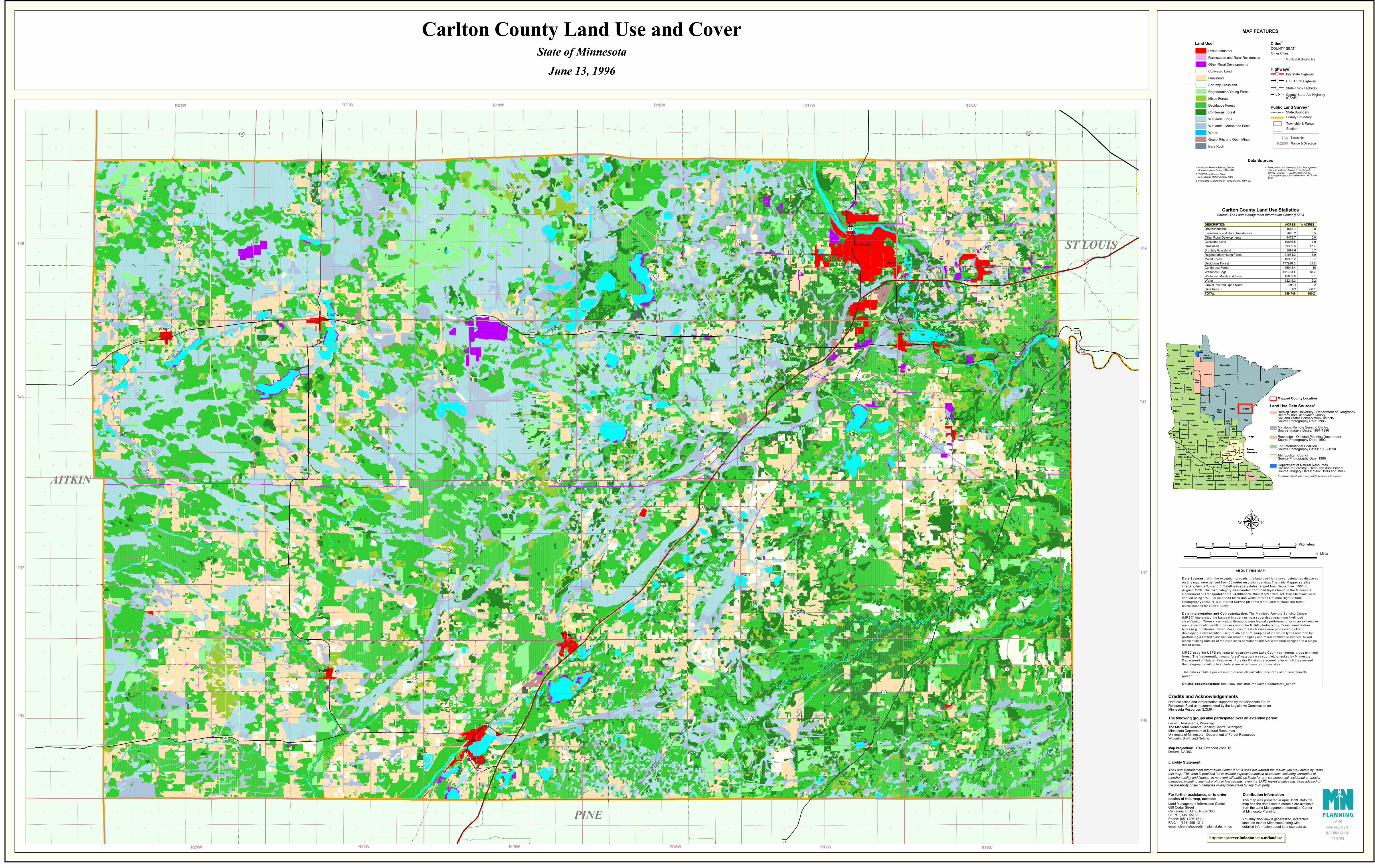
Carlton County Land Use Statistics
DESCRIPTION ACRES % ACRESUrban/Industrial 4657.1 0.8Farmsteads and Rural Residences 2620.2 0.5Other Rural Developments 4472.7 0.8Cultivated Land 10886.5 1.9Grassland 99352.5 17.7Shrubby Grassland 3897.6 0.7Regeneration/Young Forest 21951.3 3.9Mixed Forest 16992.2 3Deciduous Forest 177928.5 31.8Coniferous Forest 56048.4 10Wetlands: Bogs 101953.4 18.2Wetlands: Marsh and Fens 45603.6 8.1Water 12215.3 2.2Gravel Pits and Open Mines 996.1 0.2Bare Rock 171 < 0.1TOTAL 559,746 100%
St. LouisItascaLake
Cass
Polk
Aitkin
Pine
Cook
Koochiching
Clay
Roseau
Becker
Todd
Stearns
Kittson
Swift
Lyon
Pope
Morrison
Renville
WilkinCarlton
Hubbard
Rice
Norman
Fillmore
Wright
Mower
Crow Wing
Grant
Sibley
Brown
Clear-water
Rock
Lake of the Woods
Redwood
Kandiyohi
Jackson
Meeker
Goodhue
Isanti
Winona
Faribault
Dakota
Freeborn
Olmsted
Lincoln
Blue Earth
Scott
Anoka
Mille Lacs
Houston
SteeleDodge
Traverse
Wade-na
McLeodHennepin
Nicollet
Kana-bec
Chippewa
Benton
Wabasha
Lac Qui Parle
Carver
Pennington
Cottonwood
Big Stone
Wase-ca
Le Sueur
Yellow Medicine
Pipe-stone
Red Lake
Sherburne
# Washington# Ramsey
#Chisago
Murray
Nobles Martin
Waton-wan
Stevens
Marshall
Beltrami
Mah-nomen
Otter Tail
Douglas
# Washington# Ramsey
#Chisago
T49
T48
T47
T46
R19WR21W R16WR18WR20W R17W
ABOUT THIS MAP
Data Sources: With the exception of roads, the land use / land cover categories displayedon this map were derived from 30 meter resolution Landsat Thematic Mapper satelliteimagery, bands 3, 4 and 5. Satellite imagery dates ranged from September, 1991 toAugust, 1996. The road category was created from road layers found in the MinnesotaDepartment of Transportation's 1:24,000-scale BaseMap97 data set. Classifications wereverified using 1:60,000 color and black-and-white infrared National High AltitudePhotography (NHAP). U.S. Forest Service plot data were used to check the forestclassifications for Lake County.
Data Interpretation and Computerization : The Manitoba Remote Sensing Centre(MRSC) interpreted the Landsat imagery using a supervised maximum likelihoodclassification. Three classification iterations were typically performed prior to an exhaustivemanual verification-editing process using the NHAP photography. Transitional featuretypes (e.g. coniferous, mixed, deciduous forest classes) were processed by firstdeveloping a classification using relatively pure samples of individual types and then byperforming a limited classification around a tightly controlled confidence interval. M ixedclasses falling outside of the pure class confidence interval were then assigned to a singlemixed class.
MRSC used the USFS plot data to reclassify some Lake County coniferous areas to mixedforest. The �regeneration/young forest� category was spot field-checked by MinnesotaDepartment of Natural Resources, Forestry Division personnel, after which they revisedthe category definition to include some older trees on poorer sites.
This data exhibits a per class and overall classification accuracy of not less than 95percent.
On-line docum entation : http://lucy.lmic.state.mn.us/metadata/mrsc_lu.html