ch 7 riverfront district - trenton · buildings that step down in height and development density as...
TRANSCRIPT

Chapter 7
Riverfront District Downtown Capital District Master Plan Trenton, New Jersey

CHAPTER 7: Riverfront District
Page 48
Riverfront District Trenton will reclaim its connection with the Delaware River to enhance the experience of living, working and visiting Downtown. Route 29 will be rebuilt as an Urban Boulevard and surface parking lots will be replaced by pedestrian-oriented, mixed-use development.
Description The Riverfront District is bounded by East Lafayette on the north, U.S.
Route 1 on the south, South Broad Street on the east, and the Delaware
River on the west. Predominant land uses within this area include large
office buildings, surface parking lots and road infrastructure. This area is
the former site of Stacy Park, which was once the primary downtown open
space linking the State House to the Delaware River.
In the 1950s, the State of New Jersey purchased a large portion of Stacy Park from the City and
constructed the NJ Route 29 Freeway. This roadway provides access to Downtown Trenton from
outlying suburbs to the east and west, as well as controlled access between the north-south radial
routes that connect to New York and Philadelphia. After completion of the roadway, a series of state
office buildings were constructed with land consuming surface parking lots. As the result, Downtown
Trenton became disconnected from the river, both physically and spiritually.
Riverfront District
CHAPTER 7: Riverfront District
Downtown Capital District Master Plan Page 49 The City of Trenton, New Jersey
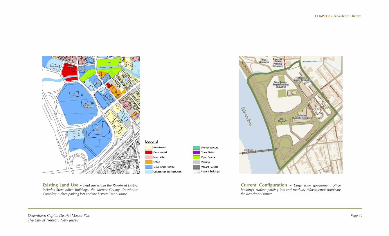
Existing Land Use – Land use within the Riverfront District includes State office buildings, the Mercer County Courthouse Complex, surface parking lots and the historic Trent House.
Current Configuration – Large scale government office buildings, surface parking lots and roadway infrastructure dominate the Riverfront District.

CHAPTER 7: Riverfront District
Page 50
Beautiful Stacy Park once served as the signature open space for the Statehouse of New Jersey and Downtown Trenton. This park was the City’s connection to the Delaware Riverfront. The park was characterized by large open lawns, quality landscape, and promenades.
In the 1950’s, Stacy Park was demolished in the name of progress when the State constructed the New Jersey Route 29 Freeway. Subsequent phases of development by government agencies have produced an area characterized by scattered office buildings, surface parking lots and disconnection from the river.
History of Stacy Park & NJ Route 29

CHAPTER 7: Riverfront District
Downtown Capital District Master Plan Page 51 The City of Trenton, New Jersey
NJ Route 29 Urban Boulevard Study New Jersey Route 29 is currently configured as a high speed freeway that runs along the riverfront in
Downtown Trenton. Multiple access points are provided from adjacent parking areas via a web of
circular ramps and drives that consume land and further restrict access to the Riverfront.
The reconstruction of Route 29 into an urban boulevard is proposed to accomplish the following goals:
Reclaim the Delaware River Waterfront
Improve Access to the Waterfront
Improve Safety and Provide Traffic Calming
Promote Urban and Economic Redevelopment
Provide Environmental Enhancements along the Assunpink Creek and Delaware River
To support the City of Trenton’s vision and goals for the Riverfront, NJ DOT conducted the Route 29
Urban Boulevard Study, with consultants Glatting Jackson Kercher Anglin Rinehart, Inc. Vollmer & Act
Engineering, to examine alignment and access alternatives for Route 29 throughout the entire length of
the City.
The recommendations contained in this Master Plan are based upon the preferred scenario identified in
the NJDOT study. The proposed alignment would veer Route 29 inland away from the River between
the State House and the U.S. Route 1 Bridge in order to recapture developable land and restore
opportunities for pedestrian access to the riverfront (see illustrations at right). This configuration recalls
the alignment of the road through historic Stacy Park that once brought motorists alongside the
landmark War Memorial building, thereby creating a memorable experience of being in Downtown
Trenton.
Proposed Road Network Reconfiguration of Route 29 into an urban boulevard, as depicted in red, is proposed to establish a signature experience for arrival into Downtown Trenton. This improvement will increase motorist and pedestrian safety while enabling access to the Delaware Riverfront. Extension of the City’s street grid in adjacent areas, as depicted in yellow, provides large-scale economic development opportunities.
Existing Road Network Route 29 is currently configured as a high-speed freeway along the Delaware River, though it is not built to modern safety standards. Multiple circular ramps and access points unnecessarily consume land. Adjacent areas are used primarily as surface parking lots.
New Street Grid

CHAPTER 7: Riverfront District
Page 52
This illustration depicts New Jersey Route 29 reconstructed as an urban boulevard and the establishment of a new mixed-use district and public amenities along the Delaware River.

CHAPTER 7: Riverfront District
Downtown Capital District Master Plan Page 53 The City of Trenton, New Jersey
Improvement Program Reconnecting Downtown Trenton to the Delaware Riverfront is a high priority for the City.
Redevelopment of the Riverfront District is envisioned to include the reconfiguration of Route 29 into
an Urban Boulevard that facilitates vehicular and pedestrian mobility through the District. Also
proposed is the replacement of surface parking lots with strategically located parking structures sized to
accommodate parking demand, and the development of mixed-use office, commercial and residential
buildings that step down in height and development density as they approach the River. Improved
pedestrian access to the River and paths along the Riverfront are envisioned to provide a signature
experience of being in Downtown Trenton.
The illustration to the left highlights redevelopment opportunities within the Riverfront District.
Opportunity sites are depicted in orange. The reconfiguration of Route 29 and the extension of the
street grid create a cluster of new development parcels to accommodate tax-generating development
in Downtown Trenton. A mix of uses is proposed that includes residential, office, retail and recreational
uses. Key projects are described in the text that follows.
A. Riverfront Low-Rise Residential/Mixed-Use This block is approximately 4.2 acres in size. Development
should be organized around an alley system to provide service
and parking access. Mixed-use with ground level commercial
and upper floor residential is proposed for the area that fronts
Route 29, with a maximum building height of four stories
recommended. Residential development is proposed for the
area that fronts the Delaware River, with a maximum building
height of three stories recommended. Opportunity sites are depicted in orange. Key sites and projects are keyed to the text that follows.

CHAPTER 7: Riverfront District
Page 54
B. Riverfront Low-Rise Residential/Mixed-Use This block is approximately 2.12 acres in size. Development should be organized around an alley
system to provide service and parking access. Mixed-use with ground level commercial and upper floor
residential is proposed for the area that fronts Route 29. A maximum building height of four stories is
recommended. Residential development is recommended along the River, with a maximum building
height of three stories.
C. Riverfront Low-Rise Mixed-Use This small block is approximately 0.75 acres in size. Service and parking access should be provided
from the northern edge of the block, and restricted from Route 29 and Market Street. Mixed-use with
ground level commercial and upper floor residential is proposed, with a maximum building height of
four stories. Market site for a signature restaurant or other entertainment destination oriented toward
the river on this high visibility parcel.
D. Assunpink Creek Office/Commercial This block is approximately 3.2 acres in size and currently contains the thirteen-story New Jersey
Department of Labor building. Infill sites fronting Assunpink Creek are identified for mixed office and
commercial development. Buildings heights should step down toward the Creek; a maximum building
height of six stories is recommended.
E. Public Square This block is approximately 2.45 acres in size. This site is partially owned by Trigen Energy Corporation,
which operates a cogeneration facility that provides for the thermal and electricity needs of over 40
buildings in Downtown Trenton.
A circular helipad covered with grass is
located in the center of the block above
the utility infrastructure. The utility use
should remain but the helipad should be
relocated to another site. This entire block
should be reconceived as a Public Square
around which development on
surrounding blocks is focused.
Landscape enhancements and pedestrian amenities should be installed around the perimeter of the
block in a way that would allow service access to the utility to be maintained.
F. Mid-Rise Mixed-Use This block is approximately 2.2 acres in size. Development should be organized around an alley
system to provide service and parking access primarily from the street that defines the north block face.
Vehicular access should be restricted from Route 29. A mix of retail, office and residential uses is
recommended for this block, with a maximum building height of thirteen stories. This block is ideal for
a mid-block parking structure around which development could be wrapped in subsequent phases of
development (if not included in an initial development phase).

CHAPTER 7: Riverfront District
Downtown Capital District Master Plan Page 55 The City of Trenton, New Jersey
G. Trent House Museum Site This 3 acre site is the founding place of Trenton and the location of the William Trent House Museum.
The proposed road reconfiguration expands the
land area dedicated to the Museum, which could
be utilized to accommodate visitor parking along
the south and east perimeters of the block. The
prominence of the intersection of Route 29 and
Market Street will secure the stature of the Trent
House as a landmark destination. Fencing and
gateway signage features should be enhanced at
this intersection.
H. Mid-Rise Mixed-Use This small block is approximately 1 acre in size, and service and parking access should be provided
from the street that defines either the west or the south block face, and restricted from South Warren
Street. A mix of office and retail uses is recommended for this block with a maximum building height of
seven stories.
I. Department of Health, Senior Services, & Agriculture Site This block is approximately 2.4 acres in size. Existing
development includes older office buildings that house the
Departments of Health, Senior Services and Agriculture. These
buildings are scheduled to be demolished within three to five years. Service and parking access should
be provided from the street that defines either the north or the south block face, and restricted from
Warren Street.
This block is ideal for a mid-block parking structure around which development could be wrapped in
subsequent phases of development if not included in an initial development phase. A mix of retail,
office and/or residential uses is recommended for this block when redeveloped with a maximum
building height of thirteen stories.
J. Mid-Rise Mixed-Use & Parking This block is approximately 2.5 acres in size. Service and parking access should be provided from the
street that defines either the north or west block face, and restricted from South Warren and Market
Streets. This block is ideal for a mid-block parking structure around which development could be
wrapped in subsequent phases of development, if not included in initial phase. A mix of retail, office
and/or residential uses is recommended, with a maximum height of 13 stories, though anticipated
building heights are four-to-six stories. The illustration to the right depicts the mixed-use office, retail
residential district envisioned for the Riverfront District of Trenton.
K. Mercer County Parking Structure Site This is the site of the proposed Mercer County Parking Structure described in detail in the Mill Hill
section of this plan. This project is reemphasized in this section because it is a key element of the
redevelopment staging. This site has capacity for 800-1,000 spaces in a new parking structure which
could be utilized to accommodate displaced parking while construction projects that include
structured parking are underway. Utilization of this parking facility could be temporary or permanent
as negotiated with Mercer County.

CHAPTER 7: Riverfront District
Page 56
This illustration depicts the character of the mixed-use office, retail residential district envisioned for the Riverfront District of Trenton.
CHAPTER 7: Riverfront District
Downtown Capital District Master Plan Page 57 The City of Trenton, New Jersey
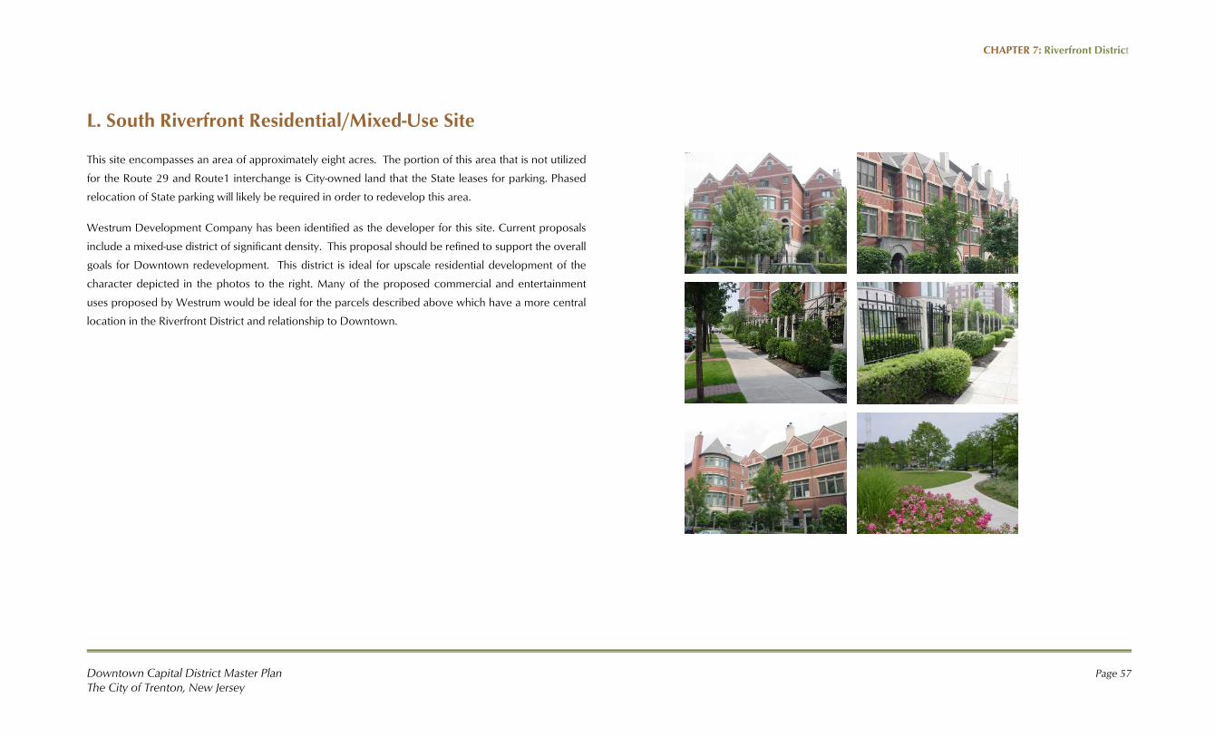
L. South Riverfront Residential/Mixed-Use Site
This site encompasses an area of approximately eight acres. The portion of this area that is not utilized
for the Route 29 and Route1 interchange is City-owned land that the State leases for parking. Phased
relocation of State parking will likely be required in order to redevelop this area.
Westrum Development Company has been identified as the developer for this site. Current proposals
include a mixed-use district of significant density. This proposal should be refined to support the overall
goals for Downtown redevelopment. This district is ideal for upscale residential development of the
character depicted in the photos to the right. Many of the proposed commercial and entertainment
uses proposed by Westrum would be ideal for the parcels described above which have a more central
location in the Riverfront District and relationship to Downtown.

CHAPTER 7: Riverfront District
Page 58
Riverfront District Character Improvements
The establishment of a high-quality public image is a key opportunity for the City of
Trenton. Public sector investments in infrastructure support elevated levels of
private sector investment in development projects.
Character imparting details, such as median treatments, signature street lighting,
landscape, signage and pedestrian amenities should be incorporated into City,
County and State designs for this area.
The images to the right depict a range of public improvements and character
details that could be emulated to enhance the function and appearance of the
Riverfront District.