chapter 2 land use element - carson, california
TRANSCRIPT

LAND USE ELEMENTCHAPTER 2
Carson General Plan LU-1 Chapter 2
CHAPTER 2
LAND USE ELEMENT
GUIDING PRINCIPLE
The City of Carson is committed to providing a sustainable balance of land
uses, including residential, commercial, industrial, educational, recreational,
and open space. The City is also committed to providing quality development
that incorporates features such as integrated, walkable, and mixed use
neighborhoods. Furthermore, the City is committed to facilitating the adaptive
reuse of former landfills and contaminated sites. The City of Carson is
committed to creating an attractive environment for its citizens by developing,
implementing and enforcing community design guidelines which will assure
quality development and the maintenance and beautification of properties.
1.0 INTRODUCTION
To quote the State’s General Plan Guidelines, “The land use element functions as a guide
to planners, the general public, and decision makers as to the ultimate pattern of
development for the city or county at buildout.”1
The Land Use Element has perhaps the broadest scope of the mandatory elements. It
plays a central role in correlating all land use issues into a set of coherent development
policies. Its objectives, policies, and programs relate directly to the other elements.
Although all general plan elements carry equal weight, the Land Use Element is often
perceived as being most representative of “the General Plan.” The Land Use Element has
1 State of California, General Plan Guidelines, Governors Office of Planning and Research, 1998, p.38.
LAND USE ELEMENT
Chapter 2 LU-2 Carson General Plan
a pivotal role in zoning, subdivision, and public works decisions. The Element’s
objectives and policies provide a long-range context for those short-term actions.
2.0 STATE LAW REQUIREMENTS
The State of California Government Code Section 65302(a) requires that a General Plan
include:
“… a land use element which designates the proposed general distribution and
general location and extent of the uses of the land for housing, business, industry,
open space including agriculture, natural resources, recreation, and enjoyment
of scenic beauty, education, public buildings and grounds, solid and liquid waste
disposal facilities and other categories of public and private uses of land. The
land use element shall include a statement of the standards of population density
and building intensity recommended for the various districts and other territory
covered by the plan which are subject to flooding and shall be reviewed annually
with respect to those areas.”
In addition to the State’s requirements set forth in the Government Code, above, it has
also been legally established that, while the location of a particular land use may be
expressed in general terms, a property owner must be able to identify the General Plan
designation for his/her parcel from the land use diagram contained in the Land Use
Element.
Among the important implementation mechanisms for the Land Use Element are
redevelopment, specific plans and the zoning ordinance. The California Government
Code requires that a city’s zoning ordinance and map be consistent with its general plan
land use element and map, and that all provisions of specific plans and redevelopment
projects adopted by a city must be consistent with the general plan they implement.
3.0 SUMMARY OF FINDINGS
3.1 LAND USE ISSUES
CARSON VISION
Prior to beginning work on the Carson General Plan Update, an extensive effort was
made to identify citizens’ concerns for the future of their City. The effort culminated in
the development of the Carson Vision, adopted by the Carson City Council on September
2, 1997. A number of methods were used to identify citizens’ concerns in the
development of the Carson Vision. These methods included group and confidential
interviews, community workshops, a random-sample community survey, meetings with a
General Plan Advisory Committee, City Council/Planning Commission Workshops,
articles in the Carson Report and press releases.
GENERAL PLAN UPDATE OUTREACH EFFORTS
Since the adoption of the Carson Vision, new information and concerns have been
identified during the General Plan Update process via the preparation of an Existing
Conditions Report, interviews and community workshops, meetings with the General
LAND USE ELEMENT
Carson General Plan LU-3 Chapter 2
Plan Advisory Committee, City Council/Planning Commission workshops, newsletter
articles, and press releases. Issues important to the City are addressed in Section 5.0,
Planning Factors, Goals, Policies, and Implementation, of this Element.
3.2 EXISTING LAND USE DESIGNATIONS AND RELATED PLANS
EXISTING GENERAL PLAN
The Carson General Plan currently consists of the State-mandated elements, such as Land
Use and Circulation, as well as what are termed “optional” elements, such as Historical
Preservation and Scenic Highway. All of these elements were adopted in 1981 and 1982,
with the exception of the Housing Element, which was last adopted in March 2002, and
the Air Quality Element, adopted in 1994.
The Land Use Element identifies land use designations and locations and a general
description of the uses permitted in each land use category. The location and extent of
land uses for each designation are illustrated on the existing General Plan Map, shown as
Exhibit LU-1, Existing General Plan. The current General Plan land use designations
include:
Low Density Residential (1-8 dus/ac.),
Medium Density Residential (9-12 dus/ac.),
High Density Residential (13-25 dus/ac.),
General Commercial,
Regional Commercial,
Light Industry,
Heavy Industry, and
Public Facilities.
CITY OF CARSON ZONING ORDINANCE
The Zoning Ordinance is the most important implementing tool for the General Plan. The
Ordinance text and Zoning Map provide permitted land uses and development standards
for each category of land use, consistent with the land use designations on the General
Plan. The Ordinance includes the following zoning classifications:
Residential Zones
RS - Residential, Single Family
RM (8) - Residential, Multiple Dwelling (up to 8 dus/ac.)
RM (12) - Residential, Multiple Dwelling (up to 12 dus/ac.)
RM (25) - Residential, Multiple Dwelling (up to 25 dus/ac.)
RA - Residential, Agriculture

LAND USE ELEMENT
Carson General Plan LU-5 Chapter 2
Commercial Zones
CN - Commercial, Neighborhood Center
CR - Commercial, Regional Center
CG - Commercial, General
Industrial Zones
ML - Manufacturing Light
MH - Manufacturing, Heavy
Open Space Zone and Special Uses
OS - Open Space
SU - Special Uses
Overlay Districts
Design Overlay
Organic Refuse Landfill Overlay
Mixed Use Residential Overlay
Electronic Marquee Signage Overlay
More detailed descriptions of these designations are given in the Existing Conditions
Report for the General Plan Update.
EXISTING LAND USE AND ZONING EQUIVALENCE
Table LU-1, Existing Development By General Plan Land Use Category With Zoning
Equivalence, provides a summary of existing General Plan land use categories and their
respective implementing zoning designation(s). Also shown in Table LU-1 is the acreage,
density/intensity, and total number of residential units or non-residential square footage
associated with each land use category.
SPECIFIC PLANS
In addition to the Zoning designations summarized above, there are five Specific Plan
areas in the City of Carson: Dominguez Technology Centre, Dominguez Hills Village,
Villages of Brighton and Strathmore (formerly Cambria Pines), Monterey Pines, and
Carson Town Center. These areas are governed by detailed land use regulations, unique
to each Specific Plan area. A full description of these Plans is given in the Existing
Conditions Report.

LAND USE ELEMENT
Chapter 2 LU-6 Carson General Plan
Table LU-1
Existing Development By General Plan Land Use Category With Zoning Equivalence
March 14, 2001
Existing General Plan Land Use Category
Existing Zoning Acreage Density/ Intensity
No. of Units/ Sq. Footage
Residential
Low Density RS, RA, RM-8 2,432.9 1 – 8 dus/ac. 18,244 dus
Medium Density RM-12 109.7 9 – 12 dus/ac. 1,127 dus
High Density RM-25 350.7 13 – 25 dus/ac. 4,203 dus
Commercial
General Commercial CG, CN 288.8 0.32 (avg.) 0.7 (max.)
2,383,114 sf
Regional Commercial CR 320.3 0.32 (avg.) 0.7 (max.)
1,652,268 sf
Industrial
Light Industry ML 1,496.6 0.34 (avg.) 0.5 (max.)
17,268,562 sf
Heavy Industry MH 4,000.2 0.2 – 0.7 (avg.)
1.0 (max.) 23,200,526 sf
Other
Public Facilities OS, SU 1,177.3 N/A
Total 10,176.4 24,830 dus*/44,504,470 * Includes 989 mobile home units currently located in areas designated for non-residential uses, as well as 267 other residential units currently located in areas designated for non-residential purposes. NOTES: 1) Acreage: Calculated by RBF Consulting, GIS Department, July 25, 2000, based on information provided by the City of Carson. 2) Residential number of units: Based on information supplied by City of Carson, GIS Department, January, 2001. Includes 989 mobile home units currently located in areas designated for non-residential uses, as well as 267 other residential units currently located in areas designated for non-residential purposes. 3) Square footage for non-residential uses: Non-residential square footages are based on information supplied by the City of Carson Planning Department, December 14, 2000, which was based on the City of Carson GIS data base (information provided by the Los Angeles County Assessors Office). 4) General Commercial: Includes Goodwill, Auto Zone, RV Center and Blockbuster projects under construction. 5) Light Industry – Includes Dominguez Technology Center, Lakeshore and Ducommun projects under construction. A total of 282,360 sq. ft of Light Industry are used for commercial purposes, including 110,700 sq. ft. at the Carson Depot Center (Home Depot) and 171,660 sq. ft. at the Super K-Mart Center. 6) Heavy Industry – Includes IDS, Watson Land (220th Street), Watson Land (Arnold Center), IDI, and the Hewson Development project on Sepulveda Boulevard, as well as the southern corners of Victoria and Figueroa Streets. A total of 361,700 sq. ft. of Heavy Industry are used for office purposes, including the Nissan headquarters. 7) Floor area ratios (FARs) – FARs for non-residential uses were developed using the City of Carson GIS data base (original information provided by the Los Angeles County Assessors Office). For purposes of estimating FARs, those properties with a “zero” value for either building or land area in the Assessors Office parcel information have not been included. Also these estimates do not include the following properties (due to the types of facilities on these properties): Shell/Ashland, ARCO, GATX, Fletcher Oil, and the Los Angeles County Sanitation District property in the southwestern corner of the City.

LAND USE ELEMENT
Carson General Plan LU-7 Chapter 2
REDEVELOPMENT PLANS
The City’s Redevelopment Agency has adopted three redevelopment project areas:
Redevelopment Project Area No. 1, Merged and Amended Redevelopment Project Area
(formerly Redevelopment Project Area No. 2 and 3), and Redevelopment Project Area
No. 4. Project Area No. 1 consists of approximately 2,044 acres, the Merged and
Amended Project Area consists of approximately 1,634 acres, and Project Area No. 4
consists of approximately 1035 acres. The Redevelopment Plans for all Project Areas are
available for review at the City of Carson, Economic Development Group.
LIVABLE COMMUNITIES PROGRAM
Through grant funding, the South Bay Cities Council of Governments (SBCCOG) has
created a guidebook entitled Creating Livable Places. The guidebook, containing
background information, a model resolution and reference materials, describes the
concepts which create livable communities. It also identifies some of the barriers which
impede the creation of such communities and strategies to overcome those barriers. The
concepts which are addressed in the guidebook include, among others, integrated
communities, design, center focus, public spaces, balanced transportation, diversity,
environmental sustainability, public safety, and full community participation.
ECONOMIC DEVELOPMENT STRATEGY
The City Council approved the City of Carson Economic Development Strategy in 1998.
This Strategy contains a Mission Statement, goals, objectives and action steps (specifying
the time frame within which the action should occur). The primary focus of the
Economic Development Strategy, as described in the Strategy’s Mission Statement, is to
“Enhance the quality of life in the City of Carson through promotion of a strong local
economy that offers growing employment and business opportunities and supports a
healthy and diversified tax base vital to the long-term viability of the City and its
citizens.” The Economic Development Strategy is on file at the City of Carson Economic
Development Group.
4.0 PLANNED LAND USE FOR THE GENERAL PLAN
4.1 DEVELOPMENT OF ALTERNATIVES
AREAS STUDIED FOR PURPOSES OF THE GENERAL PLAN UPDATE
Because the City of Carson is mature and generally built-out (approximately 9 percent of
the City is currently vacant and 8.5 percent is considered underutilized), the focus in
developing the Land Use Alternatives was on certain “Study Areas”. These areas were
identified through the work efforts and public outreach conducted during the
development of the Carson Vision and throughout the General Plan Update process.
The alternatives which were developed for purposes of the General Plan Update were
prepared with the advice of the General Plan Advisory Committee (GPAC). Land use
tours were conducted and significant research and discussion occurred in evaluating
appropriate alternatives for each of the targeted Study Areas. The results of these efforts
were the development of a Proposed Plan and two variations of that plan. Appendix G,

LAND USE ELEMENT
Chapter 2 LU-8 Carson General Plan
Study Area Recommendations, contains a written summary of the land use and policy
recommendations by Study Area and Alternative. The Study Area Location Map, shows
the locations of the Study Areas evaluated in terms of land use for the General Plan
Update. Appendix H, General Plan Land Use Alternatives, contains the alternatives
discussion.
After the completion of the GPAC recommendations, additional revisions to the existing
land use were suggested and added to the Land Use Plan. Additional study areas were
also developed. The Land Use Plan described in this Land Use Element is the plan
adopted by the City.
4.2 SPHERE OF INFLUENCE
California Law provides for county agencies called Local Agency Formation
Commissions which are charged with determining a sphere of influence for each city in
the State. The purpose of these determinations is to provide for the orderly growth and
development of urbanizing areas. Once a sphere of influence is designated, the cities can
plan and zone the areas and logical annexations to the cities can take place.
Carson’s Sphere of Influence is approximately 700 acres of an unincorporated section of
Los Angeles County located generally to the northeast of the current City boundaries. It
was designated by the Los Angeles County Local Agency Formation Commission in
1973. The unincorporated section is divided into three city spheres of influence—
Carson; Compton, to the north; and Long Beach, to the east.
Carson’s Sphere is 95 percent developed with industrial uses. There is one mobile home
park in the center of the area. The land has no known history of landfill or hazardous
waste contaminations.
Annexation proceedings have been initiated by the City in the past but none was
completed. The latest effort terminated in 1986 when Carson dropped an attempt to
annex 788 acres, including the Rancho Dominguez Seminary and Del Amo Estates
Mobile Home Park which are in the Compton Sphere of Influence. Two mobile home
park homeowners’ associations had requested the annexation.
The Sphere of Influence is included on the Land Use Plan with appropriate land uses
designated. These designations reflect the land uses existing.

LAND USE ELEMENT
Carson General Plan LU-9 Chapter 2
4.3 LAND USE DESIGNATIONS
RESIDENTIAL LAND USES
This Land Use Element classifies the residential areas of the City into Low, Medium and
High Density residential land use designations. A description of each residential land use
designation and its equivalent zoning follows.
Low Density Residential (LDR)
“Low Density Residential” includes all residential areas composed of single-family
detached dwellings and other development considered harmonious with such low density
residential development. The maximum density allowed is 8 dwelling units per acre
(du/ac). This land use category will be implemented by the RS - Residential, Single-
Family; RA - Residential Agriculture; and RM(8) - Residential Multiple Family zones.
Medium Density Residential (MD)
“Medium Density Residential” is intended to provide for multiple dwelling units, single-
family attached and detached dwellings, and other development considered harmonious
with such medium density residential development. Residential densities of up to 12
du/ac are allowed. This land use category will be implemented by the RM(12) -
Residential Multiple Family zone.
High Density Residential (HD)
“High Density Residential” areas are intended to provide for multiple dwelling units,
combinations of multiple- and single-family residential units, and other development
considered harmonious with such high density residential development. Residential
densities of up to 25 du/ac are allowed. This land use category will be implemented by
the RM(25) - Residential Multiple Family zone.
Urban Residential (UR)
“Urban Residential” is intended to provide for multiple dwelling units and a range of
commercial uses, including retail, offices, hospitals, and private community gathering
facilities. Residential densities up to 65 du/ac are allowed. The allowable density/
intensity for mixed-use development will be determined using an allowable range of FAR
(1.0 to 4.0). This land use category will be implemented with a Specific Plan zone.
COMMERCIAL LAND USES
Commercial land uses encompass those retail and service establishments which are
planned to serve neighborhood, city-wide or regional clientele. Below is a description of
each commercial land use designation, a discussion of floor-to-area ratios (FARs), and
the equivalent zoning for each designation.

LAND USE ELEMENT
Chapter 2 LU-10 Carson General Plan
General Commercial (GC)
This “General Commercial” designation includes both general and neighborhood
commercial land uses, which provide both highway-oriented and smaller neighborhood
retail opportunities. The maximum allowable FAR is 0.5, the average FAR which will
ultimately be built out for this land use is expected to be approximately 0.25 to 0.32.
This land use designation is implemented by the CN - Commercial, Neighborhood and
CG - Commercial, General zones.
Regional Commercial (RC)
The “Regional Commercial” category includes uses intended to serve a broad population
base and offer a wide range of services to both the community and the region. Businesses
in this designation include major department stores, specialty shops, other retail and
service uses, automobile and other vehicle dealerships, and hotels and motels. Regional
Commercial is intended to provide for the City’s primary regional shopping center and its
peripheral areas. Although the maximum allowable FAR is 0.6, the average FAR which
will ultimately be built out for this land use is expected to be approximately 0.32.
This land use designation is implemented by the CR - Commercial, Regional zone.
Office Park (OP)
The Office Park designation is intended to provide for the development of
professional/administrative offices and personal services rather than commodities. Site
development regulations and performance standards are designed to make such uses
relatively compatible with residential uses. The Office Park is intended to provide a
harmonious transition to residential development and neighborhoods by: 1) providing
high quality and attractive buildings that are compatible with existing and anticipated
development in the area, 2) providing open space, quality landscaping, and berms which
achieve a park-like setting, and 3) including buffering of parking, loading docks, and
other similar functions.
A new zoning designation will be developed to implement this new General Plan land use
category.
INDUSTRIAL LAND USES
Industrial areas are intended to accommodate the manufacturing, processing,
warehousing and distribution functions of the community. Below is a description of each
of the three industrial designations and the equivalent zoning for each designation.

LAND USE ELEMENT
Carson General Plan LU-11 Chapter 2
Business Park (BP)
The Business Park designation is intended to provide an attractive, high quality
industrial/business park primarily for offices, light manufacturing and assembly, and
research and development. Warehousing of a small scale (for example, no more than one
ground level loading door per x square feet of building) in conjunction with a permitted
primary use will be allowed. It may contain a very limited amount of supportive retail
and service uses, when those uses are of a scale and design providing support only to the
needs of businesses and their employees in the immediate industrial area. These are two
scales of Business Park designated in the General Plan: one for large properties that can
be planned and constructed as planned industrial/business parks, and two, for small
properties that can have adequate landscaping and small scale uses. The small scale BP
could allow churches and other institutional uses with a conditional use permit.
Both scales of Business Park are intended to provide harmonious transition to residential
development and neighborhoods by: 1) conducting all business activities and essentially
all storage inside buildings, 2) consisting of low profile, high quality, and attractive
buildings that are compatible with existing and anticipated development in the area, 3)
providing open space, quality landscaping, and berms that achieve a park-like setting, and
4) including buffering of parking, loading doors, and other similar functions. The
maximum allowable FAR is 0.5, and the average FAR which will ultimately by built out
for this land use is expected to be approximately 0.42.
Two zoning designations will be developed to implement this new General Plan land use
category. The Zoning Ordinance should provide parameters for the size and intensity of
buildings and uses.
Light Industrial (LI)
The Light Industrial designation is intended to provide for a wide variety of industrial
uses and to limit those involving hazardous or nuisance effects. Typical uses are
manufacturing, research and development, wholesaling, and warehousing. It may contain
a very limited amount of supportive retail and services uses, when those uses are of a
scale and design providing support only to the needs of businesses and their employees in
the immediate industrial area. Uses identified as not exceeding Group 3, businesses
handling acutely or highly hazardous materials, in the Hazardous Materials Disclosure
Program pursuant to the Los Angeles County Fire Code would be permitted with proper
safeguards. Performance and development standards are intended to allow a wide range
of uses as long as those uses will not adversely impact adjacent uses. Any exterior
storage and limited operations must be fully screened from any public view, and
residential and commercial uses. The maximum allowable FAR is 0.5, and the average
FAR which will ultimately be built out for this land use is expected to be approximately
0.42.
This land use designation is implemented by the ML – Manufacturing, Light zone.
Heavy Industrial (HI)
The Heavy Industrial designation is intended to provide for the full range of industrial
uses that are acceptable within the community, but whose operations are more intensive
and may have nuisance or hazardous characteristics, which for reasons of health, safety,
LAND USE ELEMENT
Chapter 2 LU-12 Carson General Plan
environmental effects, or general welfare, are best segregated from other uses.
Extractive, primary processing, construction yards, rail operations, truck yards and
terminals, and food processing industries are typical of this designation. Uses identified
as Group 4 or 5, businesses handling acutely or highly hazardous materials in the
Hazardous Materials Disclosure Program pursuant to the Los Angeles County Fire Code
would be permitted with proper safeguards. Outdoor storage operations may be
permitted, but extensive outdoor uses may require a conditional use permit. Performance
standards still must be met, but the development standards are the minimum necessary to
assure safe, functional, and environmentally sound activities. Any expansion of existing
heavy industrial uses adjacent to residential must include buffered setback areas to the
extent feasible. The designation may contain a very limited amount of supportive retail
and service uses, when those uses are of a scale and design providing support only to the
needs of businesses and their employees in the immediate industrial area. The maximum
allowable FAR is 1.0, and the average FAR upon ultimate buildout is expected to range
between 0.5 and 0.7.
This land use designation is implemented by the MH – Manufacturing, Heavy zone.
OPEN SPACE USES
The two open space designations under the Plan include “General Open Space” and
“Recreational Open Space”.
General Open Space (GOS)
“General Open Space” consists of land or water that is essentially unimproved for the
purposes of management of natural resources, production, preservation and/or
enhancement of natural resources, or public health and safety. The Dominguez Channel,
the Blimp Port, utility easements, and like uses are found within this land use category.
This land use designation will be implemented by the OS - Open Space zone.
Recreational Open Space (ROS)
The “Recreational Open Space” designation provides for public recreational uses
designed to meet the active and passive recreational needs of the community. City-owned
parks, regional parks, golf courses, and other similar uses are allowed in this category.
A more specific zoning designation, than the present OS - Open Space, will be developed
to implement this new land use category.
OTHER LAND USES
Mixed Use (MU)
The “Mixed Use” designation provides opportunities for mixtures of commercial, office,
business park/limited industrial and/or residential uses in the same building, on the same
parcel, or within the same area. There would be two MU categories—MU-R would allow
for commercial and residential uses but not business park/limited industrial and MU-BP
would allow for commercial and business park/limited industrial uses but not residential.

LAND USE ELEMENT
Carson General Plan LU-13 Chapter 2
The densities and intensities will vary within this land use designation based on actual
uses proposed. In general, it is envisioned that the maximum allowable FAR will be 0.5
for the non-residential components of any mixed use project. The residential densities
will also vary, but are expected to be in the Medium to High Density ranges, but may not
exceed 60 du/ac for the Carson Marketplace Specific Plan and 35 du/ac for all remaining
mixed use areas. Below is a description of expected square footage and number of
dwelling units for each of the Mixed Use areas:
The Carson Street Mixed Use Corridor, is designated to be MU-R, with a
combination of residential and general commercial uses, as identified in the
adopted Zoning Overlay for the area. It is anticipated that there will be an
additional 528 dwelling units and 39,600 square feet of commercial and office
uses developed over the next 20 years along this corridor. No business
park/limited industrial uses would be allowed.
All areas southwest of I-405 and north of Torrance Boulevard and the Carson
Marketplace Specific Plan site are designated MU-BP, with a combination of
regional commercial and business park/ limited industrial uses. No residential
uses would be allowed.
The Carson Marketplace Specific Plan site is designated MU-R for a
combination of residential, general commercial and regional commercial uses.
No business park/ limited industrial uses would be allowed.
South Bay Pavilion site is designated MU-R, with a combination of regional
commercial and residential uses. It is anticipated that it would be compatible
with the existing commercial uses to add some high density residential to the
eastern and southern portions of the site in place of some of the commercial floor
area. No business park/limited industrial uses would be allowed.
The area located south of Sepulveda Boulevard, generally between Marbella
Avenue and Avalon Boulevard, is designated MU-R with a combination of
residential and general commercial uses.
The area at the northeast corner of Central Avenue and Victoria Street, part of the
Dominguez Hills Village Specific Plan, is designated MU-R for a combination of
residential and general commercial uses.
A new zoning overlay will be created for each of the Mixed Use areas. These zoning
overlays could be patterned after the existing Carson Street Mixed Use Overlay Zone.
INDUSTRIAL/COMMERCIAL USES BUFFER (*)
The Industrial/Commercial Uses Buffer symbol has been added to the Land Use Plan to
indicate those areas of industrial or commercial property, generally a 100-foot strip
abutting the property line, which requires structures and uses to be set back and/or walls
and landscaping to be provided in order to buffer or protect the residential uses from the
impacts of the industrial or commercial uses.
LAND USE ELEMENT
Chapter 2 LU-14 Carson General Plan
Public Facilities (PF)
This land use designation includes a broad range of civic, governmental, institutional, and
utility related uses in Carson. Within this category are schools, public buildings and
associated grounds, and California State University at Dominguez Hills.
It is intended that a new zoning category be created to implement the Public Facilities
land use designation.
4.4 LAND USE PLAN
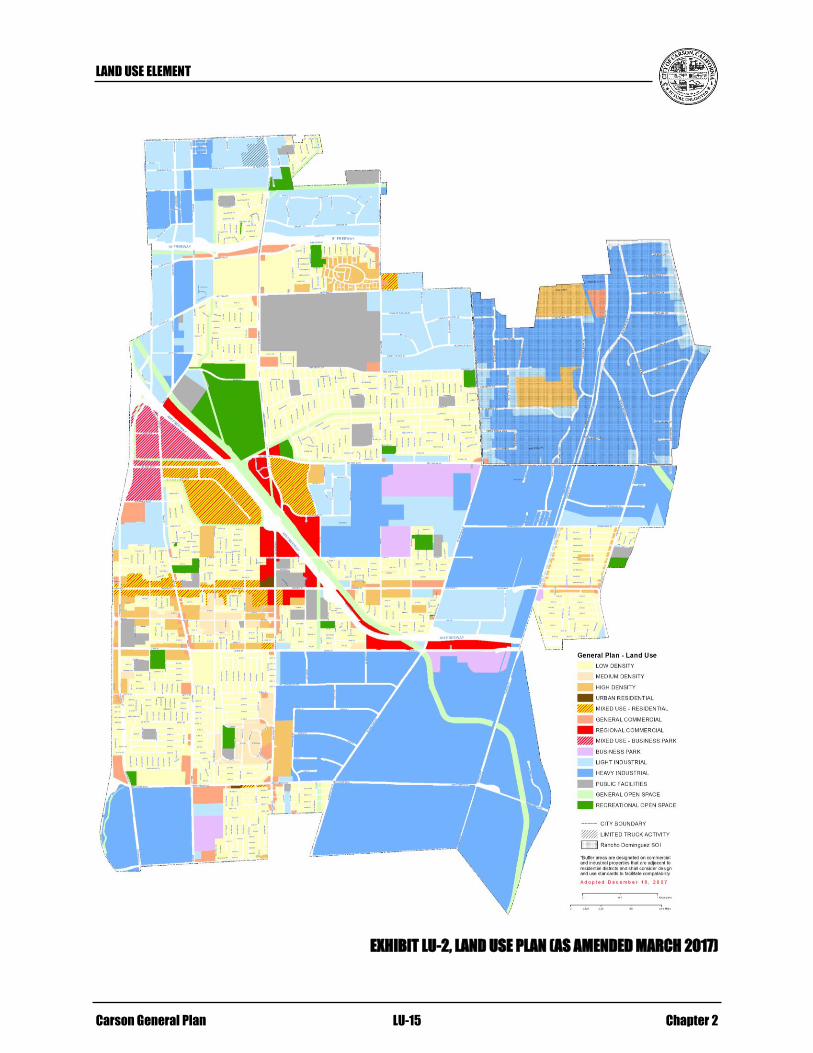
The land use plan, shown in Exhibit LU-2, Land Use Plan (As Amended March 2017), is
adopted in this Land Use Element.
LAND USE SUMMARY
Table LU-2, Land Use Summary, shows the amount of acreage in each land use category
under the Land Use Plan. Because the City is largely built out, the Plan reflects the fact
that most of the land in the City is already devoted to industrial and low density
residential uses. However, two new categories of Mixed Use have been added to provide
for the new mixed use projects described earlier in this Element.
The square footage associated with all commercial uses is expected to increase by almost
3.7 million square feet over the next 20 years. It should be noted that the General and
Regional Commercial land use categories are projected to decrease in square footage and
commercial in Mixed Use is anticipated to increase. Sites such as the Dominguez Golf
Course and the Cal Compact site are located in prime areas for commercial development.
Under the Land Use Plan there will be a net increase of almost 11.25 million square feet
of industrial land uses in the City over the next 20 years.
LAND USE ELEMENT
Carson General Plan LU-15 Chapter 2
EXHIBIT LU-2, LAND USE PLAN (AS AMENDED MARCH 2017)

LAND USE ELEMENT
Chapter 2 LU-16 Carson General Plan
Table LU-2
Land Use Summary
Land Use Acreages
Residential
Low Density 2,463.2 AC.
Medium Density 129.6 AC.
High Density 348.9 AC.
Urban Residential 6.7 AC.
Commercial
General Commercial 220.1 AC.
Regional Commercial 223.3 AC.
Industrial
Business Park 285.2 AC.
Light Industrial 2,113.0 AC.
Heavy Industrial 2,647.3 AC.
Other
Mixed Use – Residential 323 AC.
Mixed Use – Business Park 134.3 AC.
Recreational Open Space 314.7 AC.
General Open Space 225.6 AC.
Public Facilities 698.1 AC.
Total 10,133.0 AC.
More detailed information is contained in Appendix G, Study Area Recommendations,
and Appendix A, Existing and Buildout Land Use Projections.
5.0 PLANNING FACTORS, GOALS, POLICIES AND IMPLEMENTATION
The acronyms listed below are used for the implementation measures:
RA/D: Responsible Agency/Division
FS: Funding Source
TF: Time Frame
ISSUE: ADAPTIVE REUSE OF “BROWNFIELDS”
There are a number of sites in Carson with contaminated soils and groundwater,
including not only the 14 former landfills but other properties; such uses should be
remediated.
Goal: LU-1: Productive reuse of “brownfield” sites.
Policies: LU-1.1 Continue to explore the opportunities associated with the
establishment of a Brownfield Redevelopment Program.
LAND USE ELEMENT
Carson General Plan LU-17 Chapter 2
LU-1.2 Explore the opportunities associated with the establishment of a
landfill improvement district and/or like options.
LU-1.3 Monitor Federal, State and regional programs and funding
sources designed to reclaim brownfields.
LU-1.4 As projects are proposed at brownfield sites, establish a task
force to include representatives from the City and State, the
prospective developer, consultant team, and if necessary, County
and/or Federal representatives. The purpose of each task force
will be to ensure appropriate and timely development of the
brownfield site.
LU-1.5 Support, monitor and participate in the United States Conference
of Mayors and their Brownfields Redevelopment Expanded
Action Agenda.
See also the Goals and Policies in the Economic Development Element.
Implementation Measures:
LU-IM-1.1: Systematically identify contaminated sites and prioritize
those sites with the most redevelopment potential. Develop
remediation alternatives for those sites with the most
redevelopment potential. Find resources to prepare each site
for productive and desirable reuse. (Implements LU-1.1)
RA/D: Planning, Economic Development, City
Manager’s Office
FS: General Fund, State and Federal Funds/Grants
TF: Ongoing, until all contaminated sites are
redeveloped
LU-IM-1.2: Consider lobbying for legislation which will allow the City
to issue bonds to finance the development of brownfields.
Said bonds to be paid off through tenant fees within the
landfill improvement district(s). (Implements LU-1.2)
RA/D: Planning, Economic Development, City
Manager’s Office
FS: General Fund, State and Federal Funds/Grants
TF: Ongoing, until all contaminated sites are
redeveloped
LU-IM-1.3: Continue to monitor federal, state and regional programs and
funding sources to include: HUD’s and EPA’s Brownfields
Economic Development Initiative, the Department of
Transportation’s Brownfields Revitalization Initiative, the
IRS’ and Department of Treasury’s Environmental Cleanup
Cost Brownfields Tax Deduction, and similar programs.
(Implements LU-1.3)
LAND USE ELEMENT
Chapter 2 LU-18 Carson General Plan
RA/D: Planning, Economic Development, City
Manager’s Office
FS: General Fund, State and Federal Funds/Grants
TF: Ongoing, until all contaminated sites are
redeveloped
LU-IM-1.4: City Staff shall establish a task force as projects are
proposed at brownfield sites, to include representatives from
the City and State, developer, consultant team, and if
necessary, county and/or federal representatives. Each task
force will ensure that permits are secured in a timely manner,
financing is in place and new sources of funding are
identified, environmental compliance/remediation of the site
is achieved, and that state and local approval processes are
coordinated. (Implements LU-1.4)
RA/D: Planning, Economic Development, City
Manager’s Office
FS: General Fund, State and Federal Funds/Grants
TF: Ongoing, until all contaminated sites are
redeveloped
LU-IM-1.5: Encourage the Federal government to enact the following
measures:
Liability protection provided to innocent parties
involved in brownfield redevelopment,
Tax incentives provided to attract potential investors to
brownfield sites,
Increased federal program resources to assist cities with
site assessment, cleanup, redevelopment, infrastructure
improvements, and related needs,
Increased regulatory flexibility and latitude in the use of
federal resources to address brownfields needs of cities,
and
Other similar measures. (Implements LU-1.5)
RA/D: Planning, Economic Development, City
Manager’s Office
FS: General Fund, State and Federal Funds/Grants
TF: Ongoing, until all contaminated sites are
redeveloped
ISSUE: EFFECTIVE DEVELOPMENT OF UNDERUTILIZED PROPERTIES AND
REDEVELOPMENT OF THOSE PROPERTIES WHICH DETRACT FROM THE
COMMUNITY
LAND USE ELEMENT
Carson General Plan LU-19 Chapter 2
Abandoned buildings should be rehabilitated or removed. It is important that
incompatible and non-conforming uses, such as scrap yards, which detract from the
community be removed or relocated.
Goal: LU-2: Rehabilitation and/or removal of abandoned buildings and
facilities.
Policies: LU-2.1 Aggressively enforce the Property Maintenance Ordinance in
order to maintain properties in transition, abandoned residential,
commercial and industrial buildings and properties.
LU-2.2 Develop an incentive rehabilitation program to complement
mandatory code enforcement and property maintenance
programs.
Implementation Measures:
LU-IM-2.1: Use code enforcement to require owners of all abandoned
buildings and/or structures that pose safety hazards to adhere
to applicable zoning and building code standards.
(Implements LU-2.1)
RA/D: Planning
FS: General Fund
TF: Ongoing
LU-IM-2.2: Examine the potential to allow the City to fine those parties
not in compliance with the City’s Ordinance. (Implements
LU-2.1 and 2.2)
RA/D: Planning
FS: General Fund and property owner fines
TF: Ongoing
LU-IM-2.3: In the incentive rehabilitation program, explore opportunities
to provide low-interest loans and other incentives to assist
property owners in the redevelopment and/or rehabilitation
of their properties. (Implements LU-2.2)
RA/D: Planning
FS: General Fund
TF: Ongoing
LAND USE ELEMENT
Chapter 2 LU-20 Carson General Plan
Goal: LU-3: Removal of incompatible and non-conforming uses which
detract from the aesthetics and safety of the community.
Policies: LU-3.1 Continue to aggressively enforce the Non-Conforming Use
Ordinance in order to eliminate non-conforming and/or
incompatible land uses, structures and conditions.
LU-3.2 Through the zoning ordinance, control uses such as salvage
yards, automobile dismantling, and scrap metal recycling
operations which are not compatible with existing and
anticipated development.
Implementation Measures:
LU-IM-3.1: Use code enforcement to require owners of non-conforming
uses to adhere to the Non-Conforming Use Ordinance.
(Implements LU-3.1)
RA/D: Planning
FS: General Fund
TF: Ongoing
Goal: LU-4: Implementation of the Redevelopment Plan to enhance the
redevelopment project areas.
Policies: LU-4.1 Direct Redevelopment Agency investments to those economic
activities and locations with the greatest potential economic
return.
LU-4.2 Consider amending the boundaries of the Redevelopment Project
Areas to take full advantage of redevelopment tools.
LU-4.3 Bring the site assembly tools and marketing efforts of
redevelopment to bear on the revitalization of the Carson Street
Corridor and the Northwest Industrial Corridor, and to other
appropriate areas.
LU-4.4 Use redevelopment financing in conjunction with code
enforcement efforts to assist in the rehabilitation of both non-
residential and residential developments.
LU-4.5 Prioritize and coordinate redevelopment area public
improvements with those in the City’s Capital Improvement
Program.

LAND USE ELEMENT
Carson General Plan LU-21 Chapter 2
Implementation Measure:
LU-IM-4.1: Require a fiscal impact analysis for all new commercial and
industrial projects in excess of ten acres to ensure that
governmental service costs are covered by anticipated
project revenues or that a finding of special circumstance is
applied. (Implements LU-4.1 through 4.5)
RA/D: Planning
FS: Developer
TF: Ongoing
ISSUE: EXPANSION OF THE COMMERCIAL BASE
Commercial opportunities lacking in the City should be sought, including quality
restaurants and retail and commercial recreation choices.
Goal: LU-5: Maximize the City’s market potential in order to enhance and
retain shopping and entertainment opportunities to serve the
population, increase revenues to the City, and provide new
employment opportunities.
Policies: LU-5.1 Coordinate Redevelopment and Planning activities and resources
to maximize commercial opportunities.
LU-5.2 Implement and expand strategies to market, attract, and/or retain
retail commercial areas and encourage businesses to participate.
LU-5.3 Identify unique economic opportunities, such as niche markets,
that will allow the City to capitalize on its location, its cultural
diversity, and the tourism industry in the region.
LU-5.5 Utilize redevelopment planning and the City’s Capital
Improvement Program to improve infrastructure and streetscapes
throughout the City and redevelopment project areas.
LU-5.6 Provide rehabilitation assistance in targeted commercial districts
to enable the upgrading of commercial properties.
See also the Goals and Policies in the Economic Development Element.

LAND USE ELEMENT
Chapter 2 LU-22 Carson General Plan
Implementation Measures:
LU-IM-5.1: Develop strategies to focus development in targeted areas,
i.e., Carson Street, 223rd
Street Corridor, Cal Compact Site
(157-acre landfill), and other important areas within the City.
These strategies should, at a minimum address: the amount
and location of land designated for such uses, target areas,
and tools necessary to implement such strategies.
(Implements LU-5.1 and 5.2)
RA/D: Planning, Economic Development
FS: General Fund, Development Fees
TF: Ongoing
LU-IM-5.2: Periodically evaluate which retail categories are
experiencing leakage. And approach existing retailers within
these categories (specifically the higher-scale restaurants and
retailer) and encourage their relocation to, or expansion in,
Carson. (Implements LU-5.1 through 5.4)
RA/D: Planning, Economic Development
FS: General Fund, Development Fees
TF: Ongoing
LU-IM-5.3: Encourage higher-scale restaurants to locate in clusters in
areas targeted for specialty retail. (Implements LU-5.1
through 5.4)
RA/D: Planning, Economic Development
FS: General Fund
TF: Ongoing
LU-IM-5.4: Monitor development of “catalyst” land uses (e.g., hotels,
regional office space, etc.) to identify “follow-on”
development opportunities for related land uses (e.g.,
entertainment and recreation facilities to serve hotel guests
and business hotels to serve office users). (Implements LU-
5.1 through 5.4)
RA/D: Planning, Economic Development
FS: General Fund, Development Fees
TF: Ongoing
LU-IM-5.5: Continue to coordinate with the Chambers of Commerce,
Los Angeles County economic development groups, and
other business associations to retain and attract businesses.
(Implements LU- 5.1 through 5.4)
RA/D: Economic Development
FS: General Fund, Development Fees
TF: Ongoing

LAND USE ELEMENT
Carson General Plan LU-23 Chapter 2
LU-IM-5.6: Encourage support services as part of industrial/ commercial
development (i.e., child care, convenience shopping,
personal services, restaurants, etc.). (Implements LU-5.1, 5.2
and 5.4)
RA/D: Planning, Economic Development
FS: General Fund, Development Fees
TF: Ongoing
LU-IM-5.7: Use redevelopment tools to assemble land, assist
development and provide for on-going area improvement.
(Implements LU-5.1 through 5.6)
RA/D: Economic Development
FS: Redevelopment Fees
TF: Ongoing
LU-IM-5.8: Encourage specialty retail development to concentrate in
targeted areas of the City to enable “critical mass” thresholds
of such uses to be established. (Implements LU-5.2 through
5.4)
RA/D: Planning, Economic Development
FS: General Fund
TF: Ongoing
LU-IM-5.9: Target, through the Capital Improvement Program, those
areas and/or structures in most need of improvement,
focusing on targeted redevelopment project areas.
(Implements LU-5.5 and 5.6)
RA/D: Planning, Economic Development
FS: General Fund, Redevelopment funds
TF: Ongoing
LU-IM-5.10: Provide informational material to the owners of properties in
targeted commercial areas identifying the types of assistance
available and work with them in the upgrading of their
properties. (Implements LU- 5.6)
RA/D: Planning, Economic Development
FS: General Fund, Redevelopment funds
TF: Ongoing
ISSUE: A BALANCE OF USES
A land use plan which provides a balance of residential, commercial, industrial,
educational, recreational and civic facilities which meet the needs of the citizens of
Carson.

LAND USE ELEMENT
Chapter 2 LU-24 Carson General Plan
Goal: LU-6: A sustainable balance of residential and non-residential
development and a balance of traffic circulation throughout the
City.
Policies: LU-6.1 Monitor development trends in Carson to ensure that future
development/redevelopment provides for the needs of the
community.
LU-6.2 Achieve a sustainable land use balance through provision of
incentives for desired uses; coordination of land use and
circulation patterns; and promotion of a variety of housing types
and affordability.
LU-6.3 Consider establishing minimum land use density requirements in
certain areas such as mixed use zones to provide more efficient,
consistent, and compatible development patterns while also
promoting greater potential for pedestrian and transit-oriented
development.
LU-6.4 Coordinate redevelopment and planning activities and resources
to balance land uses, amenities, and civic facilities.
LU-6.5 Coordinate strategies with the County, Southern California
Association of Governments (SCAG), South Bay Cities Council
of Governments (SBCCG), and other appropriate agencies
and/or organizations to meet housing and employment needs.
LU-6.6 Attract land uses that generate revenue to the City of Carson,
while maintaining a balance of other community needs such as
housing, open space, and public facilities.
LU-6.7 Implement and monitor the development intensities identified
earlier in this Element. Periodically review these intensities and
densities based on market demand and other conditions to
confirm their appropriateness.
LU-6.8 Manage truck-intensive uses.

LAND USE ELEMENT
Carson General Plan LU-25 Chapter 2
Implementation Measures:
LU-IM-6.1: Review the General Plan and Land Use Map to identify the
effect of land development and uses in the community on
City revenue and costs of providing public facilities and
services. (Implements LU-6.1, 6.4, 6.6, 6.7, and 6.8)
RA/D: Planning
FS: General Fund
TF: Annually
LU-IM-6.2: Provide incentives for desired commercial and industrial
uses. (Implements LU-6.1, 6.2 and 6.6)
RA/D: Planning, Economic Development
FS: General Fund
TF: Ongoing
LU-IM-6.3: Coordinate land use and circulation patterns to ensure proper
circulation capacity and infrastructure. (Implements LU-6.1,
6.2, and 6.8)
RA/D: Planning, Public Works
FS: General Fund
TF: Ongoing
LU-IM-6.4: Promote a variety of housing types and affordability to meets
the development goals of the Housing Element, and provide
needed housing opportunities to support employment
growth. (Implements LU-6.1, 6.2, and 6.5)
RA/D: Planning
FS: General Fund
TF: Ongoing
LU-IM-6.5: Periodically review the General Plan intensities and densities
of development. This review should examine market demand
and other conditions to confirm the appropriateness of these
densities and intensities. When necessary, establish
minimum land use density requirements. (Implements LU-
6.1, 6.3, and 6.6 through 6.8)
RA/D: Planning, Economic Development
FS: General Fund
TF: Annually, or as necessary on a project-by-project
basis
LU-IM-6.6: Conduct systematic monitoring of the impact and intensity
of development in Carson and areas around the City to
ensure that affected public agencies can provide necessary

LAND USE ELEMENT
Chapter 2 LU-26 Carson General Plan
facilities and services in support of that development.
(Implements LU-6.1, 6.4, 6.6, and 6.8)
RA/D: Planning, Public Works
FS: General Fund, Development fees
LU-IM-6.7: Review carefully any zone change and/or General Plan
Amendment to permit development or modify intensity.
Factors to be considered include, but are not limited to: the
maximum intensity allowed pursuant to the General Plan;
circulation patterns; environmental constraints; and
compatibility with surrounding land uses. (Implements LU-
6.7 and 6.8)
RA/D: Planning
FS: General Fund
TF: Ongoing on a project-by-project basis
LU-IM-6.8: Analyze the Zoning Ordinance for truck-intensive uses,
determine how such uses may impact other land uses, traffic,
and truck routes, and make changes as necessary to the uses
permitted and the review processes required. Such changes
shall include a jobs and fiscal impact report to determine
affects of the proposed changes to uses permitted and review
process required. (Implements LU-6.8)
RA/D: Planning
FS: General Fund
TF: 2003-05
ISSUE: INCOMPATIBLE LAND USES
Incompatible land uses immediately adjacent to one another, such as residential and
industrial uses, may significantly hinder the health of a community. Uses should be
appropriately buffered or incompatibilities addressed through redesignation of uses in
the area.
Goal: LU-7: Adjacent land uses that are compatible with one another.
Policies: LU-7.1 Periodically review, and amend if necessary, the City’s Zoning
Ordinance to ensure the compatibility of uses allowed within
each zoning district.
LU-7.2 Locate truck intensive uses in areas where the location and
circulation pattern will provide minimal impacts on residential
and commercial uses.
LU-7.3 Promote the use of buffers between more intensive industrial
uses and residential uses.

LAND USE ELEMENT
Carson General Plan LU-27 Chapter 2
LU-7.4 Through the discretionary review process, ensure that the siting
of any land use which handles, generates, and/or transports
hazardous substances will not negatively impact existing
sensitive receptor land uses.
LU-7.5 Monitor existing uses, and carefully review all new proposals to
expand intensive commercial and industrial uses.
LU-7.6 Coordinate with adjacent landowners, cities and the County in
developing compatible land uses for areas adjacent to the City’s
boundaries.
LU-7.7 Coordinate with California State University at Dominguez Hills
in the planning of its property to ensure compatible land uses.
Implementation Measures:
LU-IM-7.1: Amend the Zoning Ordinance to accommodate the Office
Park, Business Park, Mixed Use, General Open Space, and
Recreational Open Space land use designations. And amend
the Zoning Map to be consistent with the adopted General
Plan Map. In addition, review and amend the Zoning
Ordinance to: clarify permitted and conditionally permitted
uses in all districts (i.e., churches and other uses); and to
address non-conforming uses. (Implements LU-7.1)
RA/D: Planning
FS: General Fund
TF: Within one year
LU-IM-7.2: Establish zoning standards that properly designate uses
appropriate for Office Park, Business Park, Light Industrial
and Heavy Industrial areas. (Implements LU-7.1)
RA/D: Planning
FS: General Fund
TF: Within one year, and periodically updated
LU-IM-7.3: Where a discretionary review may be required, address
compatibility issues (e.g., maneuverability of trucks on site,
scheduling and hours of operation, visual screening, noise,
etc.). (Implements LU-7.2)
RA/D: Planning
FS: Development
TF: Ongoing
LU-IM-7.4: Review and amend, as necessary, the Zoning Ordinance to
provide consistency with new State legislation and court
decisions. (Implements LU-7.1 and 7.2)

LAND USE ELEMENT
Chapter 2 LU-28 Carson General Plan
RA/D: Planning
FS: General Fund
TF: Annually
LU-IM-7.5: Review and amend, as necessary, the City’s Subdivision
Ordinance to provide consistency with new State legislation
and court decisions, and to make other desired changes to
provisions of the ordinance. (Implements LU-7.1 and 7.2)
RA/D: Planning, Public Works
FS: General Fund
TF: Annually
LU-IM-7.6: Use buffers such as the Business Park land use designation
and the Commercial Uses/Industrial Buffer symbol between
more intensive industrial uses and residential uses. Require
that commercial and industrial development which adjoins
residential uses be adequately screened and buffered from
the residential neighborhood(s). (Implements LU-7.4 and
7.6)
RA/D: Planning
FS: General Fund and Development Fees
TF: Annually
LU-IM-7.7: Utilize the site development permit process and the
California Environmental Quality act in the review of
proposed development projects to promote compatibility and
minimize environmental impacts. Where uses are marginally
compatible, require a Conditional Use Permit and consider
special mitigation measures. (Implements LU-7.3 through
7.8)

LAND USE ELEMENT
Carson General Plan LU-29 Chapter 2
RA/D: Planning
FS: Development Fees
TF: Ongoing
LU-IM-7.8: Continue to enforce the Zoning and other ordinances to
achieve the desired level of regulation. (Implements LU- 7.3
through 7.8)
RA/D: Planning
FS: General Fund
TF: Ongoing
LU-IM-7.9: Develop landscape requirements for public and private
development projects to promote greater visual and
functional compatibility with residential development.
(Implements LU-7.4 and 7.6)
RA/D: Planning
FS: General Fund
TF: Within two years
ISSUE: MIXED USE DEVELOPMENTS
There is a need for mixed use developments which provide a variety of uses, including
residential, retail, office, limited industrial, and recreational. Such projects should
provide an integrated development theme, quality design, easy access to public
transportation, and a safe environment.
Goal: LU-8: Promote mixed use development where appropriate.
Policies: LU-8.1 Amend the Zoning Ordinance to provide for those Mixed Use
areas identified on the General Plan Land Use Plan.
LU-8.2 Continue to monitor the success of mixed use projects within the
Carson Street mixed use corridor and promote mixed use
projects at appropriate sites within this area.
LU-8.3 Locate higher density residential uses in proximity to
commercial centers in order to encourage pedestrian traffic and
provide a consumer base for commercial uses.
Implementation Measures:
LU-IM-8.1: Amend the Zoning ordinance to include those Mixed Use
areas identified on the General Plan Land Use plan,
specifically:
The area formerly occupied by Cal Compact (157-acre
landfill), along the 405 Freeway; uses to be permitted

LAND USE ELEMENT
Chapter 2 LU-30 Carson General Plan
include a mix of High Density Residential, General
Commercial and Regional Commercial.
The Carson Street Corridor between Avalon Boulevard
and the western City Limits; uses to be permitted include
a mix of General Commercial, and Medium and High
Density Residential.
The area formerly occupied by the Samerika Hall
northwest of the intersection of Avalon Boulevard and
223rd
Street; uses to be permitted include a mix of
General Commercial, and Low, Medium and/or High
Density Residential.
The South Bay Pavilion site; uses to be permitted
include Regional Commercial and Medium and High
Density Residential.
(Implements LU-8.1 through 8.3)
RA/D: Planning
FS: General Fund
TF: Within one year
ISSUE: PROPERTY ENHANCEMENT
Property maintenance is important in Carson. In both residential neighborhoods and
non-residential areas, focus should be placed on property maintenance and
improvement.
Goal: LU-9: Eliminate all evidence of property deterioration throughout
Carson.
Policies: LU-9.1 Aggressively enforce the City’s codes.
LU-9.2 Develop incentive programs for the improved appearance of
residential, commercial and industrial areas.
LU-9.3 Continue to promote and expand programs such as the Carson
Beautiful Program which recognize excellence in property
upkeep in residential areas.
LU-9.4 Continue to promote programs which offer loans and grants for
home repairs.
LU-9.5 Develop design standards to address permanent and effective
screening of areas in transition and heavy industrial uses such as
outdoor storage yards, pallet yards, salvage yards, auto
dismantling yards, and similar uses.

LAND USE ELEMENT
Carson General Plan LU-31 Chapter 2
LU-9.6 Continue to maintain graffiti suppression and removal programs.
LU-9.7 Maintain and upgrade the City’s parks, eliminating evidence of
vandalism, wear and deterioration.
LU-9.8 Maintain City properties in compliance with applicable
regulations and adhere to design and maintenance standards as a
model for private development.
Implementation Measures:
LU-IM-9.1: Strengthen the City’s code enforcement program. To this
end, conduct windshield surveys in order to identify zoning
and code enforcement infractions on all times of day and
days of the week. Also, consider the development of a
program by which fines are imposed if properties are
repeatedly not maintained. (Implements LU-9.1)
RA/D: Planning
FS: General Fund
TF: Ongoing
LU-IM-9.2: Develop firm and fair code enforcement policies understood
and supported by residents and business owners.
(Implements LU-9.1)
RA/D: Planning
FS: General Fund
TF: Ongoing
LU-IM-9.3: Adopt a property maintenance ordinance. (Implements LU-
9.1)
RA/D: Planning
FS: General Fund
TF: Within two years
LU-IM-9.4: Implement the housing rehabilitation policies adopted in the
Carson Housing Element. (Implements LU-9.1 through 9.4)
RA/D: Planning
FS: General Fund
TF: Ongoing
LU-IM-9.5: In areas where deferred maintenance is visible, assist with:
Maintenance loans or grants,
Rehabilitation loans or grants,
Tool banks, and/or
Instructional programs in property maintenance skills
and techniques. (Implements LU-9.2 and 9.4)

LAND USE ELEMENT
Chapter 2 LU-32 Carson General Plan
RA/D: Planning
FS: General Fund, State and Federal monies
TF: Ongoing
LU-IM-9.6: Support and expand public programs, such as Neighborhood
Pride and the Homes and Gardens Improvement Programs.
To this end, publicize the loans and grants available, as well
as the achievements of neighborhoods and non-residential
areas which have improved maintenance and appearance.
(Implements LU-9.2 through 9.4)
RA/D: Planning, Public Information, Public Services
FS: General Fund, State and Federal monies
TF: Ongoing
LU-IM-9.7: Develop a design and improvement plan based on the City
Capital Improvement Plan including strengthened
landscaping, identification graphics, and other physical
improvements to enhance major public thoroughfares and
activity areas. (Implements LU-9.3)
RA/D: Planning, Public Works
FS: General Fund
TF: Within two years, and annually updated with
budget process
LU-IM-9.8: Review and amend the City’s Zoning Ordinance to include
the screening and landscaping of commercial and/or
industrial properties which have been abandoned.
(Implements LU-9.5)
RA/D: Planning
FS: General Fund and Development Fees
TF: Within two years
LU-IM-9.9: Review and amend the City’s Zoning Ordinance to address
the permanent and effective screening of heavy industrial
uses such as outdoor storage yards, pallet yards, salvage
yards, auto dismantling yards, and similar uses. (Implements
LU-9.5)
RA/D: Planning
FS: General Fund and Development Fees
TF: Within two years
ISSUE: ALAMEDA CORRIDOR
While there are distinct advantages to the Alameda Corridor, there are also
disadvantages. Traffic, noise and economic impacts to businesses and residential
neighborhoods immediately adjacent are among the primary issues.

LAND USE ELEMENT
Carson General Plan LU-33 Chapter 2
Goal: LU-10: Development along the Alameda Corridor which is beneficial to
residents, property owners, businesses, and the City.
Policies: LU-10.1 Continue to work with regional and State agencies to ensure
adequate transportation facilities along the Corridor to serve the
adjacent areas.
LU-10.2 Work with the existing applicable task forces and prepare a
special study for those areas adversely impacted by the
development of the Corridor.
LU-10.3 Promote the benefits of the Alameda Corridor to businesses and
industries considering relocating to Carson.
Implementation Measures:
LU-IM-10.1: Prepare a special study for those area(s) adversely impacted
by the development of the Corridor, specifically that area
east of the Alameda Corridor, between Dominguez Street
and the southern boundary of the City. Provide appropriate
mitigation for the impacts associated with the Corridor on
the neighborhood. (Implements LU-10.2)
RA/D: Planning
FS: General Fund
TF: Within two years
See also LU-IM-85.
LU-IM-10.2: Develop a program which specifically identifies and markets
the benefits of the Alameda Corridor within the City of
Carson. (Implements LU-10.3)
RA/D: Economic Development, Development Services
FS: General Fund
TF: Within two years
ISSUE: DEVELOPMENT OF A “SIGNATURE PROJECT”
It is important to develop a focal point within the community, such as a “Main Street”
along the Carson Street Corridor or a “Signature Project” along the I-405 Freeway.
Quality retail and restaurant uses, as well as entertainment uses such as movie theaters,
performing arts center, or other commercial recreational uses would locate in such an
area. It would be an area serving the entire region, for which the City would become
known.
Goal: LU-11: Development of one or more “Signature Project” to create a
focal point or points for the City.

LAND USE ELEMENT
Chapter 2 LU-34 Carson General Plan
Policies: LU-11.1 Target potential sites or areas for the development of signature
projects.
LU-11.2 Encourage development of desired uses such as quality retail,
restaurant uses, and entertainment in targeted areas.
See also the Goals and Policies in the Economic Development Element.
Implementation Measures:
LU-IM-11.1: Determine which sites or areas would be most appropriate
for a “Signature Project” in Carson. Pursue development at
these site(s) or area(s) which would support the purpose of
creating such a project. Sites for consideration include, but
are not limited to: Carson Street and the site formerly
occupied by Cal Compact (157-acre landfill). (Implements
LU-11.1)
RA/D: Planning, Economic Development
FS: General Fund
TF: Within two years
LU-IM-11.2: Determine what type of facilities/uses would be desirable in
a “Signature Project.” This determination should be based on
market considerations as well as community support.
(Implements LU-11.2)
RA/D: Planning, Economic Development
FS: General Fund
TF: Within two years
LU-IM-11.3: Consider offering public incentives, such as assistance in the
assembly of land, to promote the development of a project.
(Implements LU-11.1)
RA/D: Planning, Economic Development
FS: General Fund, Redevelopment Funds
TF: As needed
ISSUE: CITY IMAGE
There are a number of unattractive and/or nonconforming land uses located along highly
visible freeway corridors which impact the public’s perception of the community. Many
of these properties are located in areas which can be considered “gateways” into the
City. Appropriate screening, landscaping and buffering should be encouraged in order to
improve the City’s image. In addition, entries into the City and key streets should be
enhanced with landscaping and entry statements as appropriate.
Goal: LU-12: Create a visually attractive appearance throughout Carson.
LAND USE ELEMENT
Carson General Plan LU-35 Chapter 2
Policies: LU-12.1 Develop and implement a Citywide Urban Design Plan.
LU-12.2 Adopt a “Carson Green” program to encourage public/private
partnerships in the landscaping of the community.
LU-12.3 Review landscape plans for new development to ensure that
landscaping relates well to the proposed land use, the scale of
structures, and the surrounding area.
LU-12.4 Amend the landscaping requirements in the Zoning Ordinance to
enhance the appearance of the community and to provide for the
use of trees to provide shade.
LU-12.5 Improve City appearance by requiring landscaping to screen,
buffer and unify new and existing development. Mandate
continued upkeep of landscaped areas.
Implementation Measures:
LU-IM-12.1: Develop a Citywide Urban Design Plan which addresses:
Site planning and design,
Architectural design guidelines,
Landscape programs,
Entries into the city,
View corridors such as the I-405 and I-110 Corridors,
Streetscape programs (to include street furnishings,
lighting, walls and fencing, monumentation),
Design guidelines appropriate for each area of the City,
Financing, and
Priorities. (Implements LU-12.1)
RA/D: Planning
FS: General Fund, Development Fees
TF: Within three years
LU-IM-12.2: Provide economically feasible Urban Design Plan
implementation strategies by:
Establishing public/private partnerships,
Researching funding sources, and
Prioritizing design projects to be scheduled within the
City’s Capital Improvement Program. (Implements LU-
12.1)
RA/D: Planning
FS: General Fund, Development Fees
TF: Ongoing

LAND USE ELEMENT
Chapter 2 LU-36 Carson General Plan
LU-IM-12.3: Foster neighborhood participation in the program.
(Implements LU-12.2)
RA/D: Planning, Public Information, Public Services
FS: General Fund
TF: Ongoing
LU-IM-12.4: Encourage business organizations to support and participate
in the program. (Implements LU-12.2)
RA/D: Planning, Public Information, Public Services
FS: General Fund
TF: Ongoing
LU-IM-12.5: Collaborate with the School District and local civic
organizations to celebrate Arbor Day by planting trees on
public lands. (Implements LU-12.2)
RA/D: Planning, Public Information, Public Services
FS: General Fund
TF: Ongoing
LU-IM-12.6: Require new development to incorporate street tree planting
mature enough to shade and beautify the area. (Implements
LU-12.3)
RA/D: Planning
FS: Development
TF: Ongoing
LU-IM-12.7: Require new development processed as a Planned Unit
Development to ensure permanent maintenance of
landscaped areas through maintenance agreements,
“Conditions, Covenants and Restrictions”, or similar
contracts guaranteeing perennial maintenance. (Implements
LU-12.3 and 12.5)
RA/D: Planning
FS: Development
TF: Ongoing
LU-IM-12.8: Address tree preservation and the removal and replacement
of mature trees in the landscape section(s) of the City’s
Ordinance. (Implements LU-12.4)
RA/D: Planning
FS: General Fund
TF: Within three years
LU-IM-12.9: Enhance landscaping requirements and maintenance
standards in the landscape section(s) of the City’s Ordinance.
(Implements LU-12.4)

LAND USE ELEMENT
Carson General Plan LU-37 Chapter 2
RA/D: Planning
FS: General Fund
TF: Within three years
LU-IM-12.10: Encourage drought tolerant plant species, water conservation
and related features in the landscape section(s) of the City’s
Ordinance. (Implements LU-12.4)
RA/D: Planning
FS: General Fund
TF: Within three years
LU-IM-12.11: Require exposed structural sidewalls to be screened with
landscaping. (Implements LU-12.5)
RA/D: Planning
FS: Development
TF: Ongoing
LU-IM-12.12: Require landscaping to provide visual continuity along a
street, even where the buildings are in different zones or land
use districts. (Implements LU-12.5)
RA/D: Planning
FS: Development
TF: Ongoing
LU-IM-12.13: When conflicting land uses adjoin, require a dense landscape
screen to mitigate the friction between land uses.
(Implements LU-12.5)
RA/D: Planning
FS: Development
TF: Ongoing
Goal: LU-13: Encourage interesting and attractive streetscapes throughout
Carson.
Policies: LU-13.1 Promote a rhythmic and ceremonial streetscape along the City’s
arterial roadways, continuing the use of landscaped medians.
LU-13.2 Develop a street tree planting and replacement program for the
City’s arterial roadways.
LU-13.3 Continue and, when possible, accelerate the undergrounding of
utility lines throughout the City.
LU-13.4 Encourage architectural variation of building and parking
setbacks along the streetscape to create visual interest, avoid
monotony and enhance the identity of individual areas.
Encourage pedestrian orientation by appropriate placement of
buildings.

LAND USE ELEMENT
Chapter 2 LU-38 Carson General Plan
LU-13.5 Continue to require landscaping treatment along any part of a
building site which is visible from City streets.
LU-13.6 Consider the use of contrasting paving for pedestrian crosswalks
to add visual interest to the streetscape and create pedestrian
amenity.
LU-13.7 Ensure proper maintenance of parkways along arterial streets and
landscaping of private property visible from the public right-of-
way.
Implementation Measures:
LU-IM-13.1: Examine the potential of extending special median
treatments along the entire lengths of important arterials and
prioritize these treatments. (Implements LU-13.1)
RA/D: Planning, Public Works
FS: General Fund, Development Fees
TF: Ongoing
LU-IM-13.2: Encourage new developments along arterials scheduled for
median extension to provide landscaped medians adjacent to
the development. (Implements LU-13.1)
RA/D: Planning, Public Works
FS: General Fund, Development Fees
TF: Ongoing
LU-IM-13.3: Require a comprehensive landscape and streetscape program
to be developed for critical corridors such as Carson Street,
Main Street, Avalon Boulevard, and Wilmington Avenue
(with these corridors given priority). The program should
include guidelines for banners, signage, landscaping,
lighting, and street furniture. In addition, consideration
should be given to: the incorporation of gardens and
landscape areas in both public and private developments;
pedestrian orientation; and public transit opportunities.
(Implements LU-13.2)
RA/D: Planning, Public Works
FS: General Fund, Development Fees
TF: Within three years
LU-IM-13.4: Examine the potential to develop the following in an effort
to facilitate the beautification of important corridors:
Benefit Assessment District,
Lighting and Maintenance Assessment District,
Parking District,

LAND USE ELEMENT
Carson General Plan LU-39 Chapter 2
Business Association,
Street Overlay District, and
Merchant’s Association. (Implements LU-13.2)
RA/D: Planning, Public Works
FS: General Fund, Fees
TF: Within three years
LU-IM-13.5: Continue to require the undergrounding of utilities through
the City’s standard list of conditions. (Implements LU-13.3)
RA/D: Planning
FS: General Fund, Development Fees
TF: Ongoing
LU-IM-13.6: Continue to pursue funding sources for the undergrounding
of utilities throughout the City. (Implements LU-13.3)
RA/D: Planning
FS: General Fund, other funding sources
TF: Ongoing
LU-IM-13.7: Require electrical vaults which are placed above ground to
be aesthetically screened. (Implements LU-13.3)
RA/D: Planning
FS: General Fund, Development Fees
TF: Ongoing
LU-IM-13.8: Require that all sides of a building visible from City streets
display fully finished architectural detail, including: finished
doors, and windows and exterior surfaces identical to, or
which complement, the front of the building. (Implements
LU-13.4)
RA/D: Planning
FS: Development
TF: Ongoing
Goal: LU-14: Enhance freeway corridors and major arterials which act as
gateways into the City of Carson.
Policies: LU-14.1 Work with Caltrans to provide and maintain an attractive
freeway environment in Carson, including access ramps.
LU-14.2 Require new commercial or industrial development adjacent to
and visible from freeways and freeway ramps to incorporate full
architectural and landscape treatment of the building on the
freeway side.
LU-14.3 Seek all available funds and consider using redevelopment funds
to enhance freeway portals into the City.
LAND USE ELEMENT
Chapter 2 LU-40 Carson General Plan
LU-14.4 Provide entry markers with landscaping on the major arterials.
Implementation Measures:
LU-IM-14.1: Provide and properly maintain appropriate freeway
landscaping. (Implements LU-14.1)
RA/D: Caltrans with cooperation of Planning, Public
Works
FS: State and Federal monies, General Fund
TF: 2003-05
LU-IM-14.2: Enhance the landscaping near freeway on- and off-ramps to
announce the driver’s entry into Carson. (Implements LU-
14.1)
RA/D: Planning, Public Works
FS: General Fund, state and federal monies
TF: Ongoing
LU-IM-14.3: Improve the surfaces of freeway structures visible to
travelers with scoring, tile, landscaping, or other treatments
to improve the raw, unfinished appearance of these
structures. (Implements LU-14.1)
RA/D: Caltrans with cooperation of Planning, Public
Works
FS: State and Federal monies, General Fund
TF: Ongoing
LU-IM-14.4: Require the design of new buildings visible from the freeway
and its ramps to include:
Variation in plane and texture sufficient to prevent
monotonous or massive appearance from the freeway,
Adequate landscaping on all parts of the site visible from
the freeway,
Architectural accent through use of trim materials,
accent color, pop-out and recessed relief features,
Fully finished window details, and
Concealment of mechanical equipment on the roof.
(Implements LU-14.2)
RA/D: Planning
FS: Development
TF: Ongoing
LU-IM-14.5: Design and fund attractive entry markers and areas for the
major arterials.

LAND USE ELEMENT
Carson General Plan LU-41 Chapter 2
RA/D: Planning, Engineering
FS: General Fund, Gas Tax, grant funds
TF: 2003-05
ISSUE: LIVABLE COMMUNITIES
As part of a nationwide effort to address urban sprawl, neighborhood safety, pedestrian
access and environmental protection, the South Bay Cities Council of Governments,
which the City of Carson is a part, has developed a program which identifies planning
concepts to be used creating Livable Communities.
Goal: LU-15: Promote development in Carson which reflects the “Livable
Communities” concepts.
Policies: LU-15.1 Encourage the location of housing, jobs, shopping, services and
other activities within easy walking distance of each other.
LU-15.2 Maintain a diversity of housing types to enable citizens from a
wide range of economic levels and age groups to live in Carson.
LU-15.3 Ensure that community transportation facilities are connected to
a larger transit network.
LU-15.4 Develop a center focus within the community that combines
commercial, civic, cultural and recreational uses.
LU-15.5 Ensure that the design of public spaces encourages the attention
and presence of people at all hours of the day and night.
LU-15.6 Ensure development of pedestrian-oriented improvements which
provide better connections between and within all developments
while reducing dependence on vehicle travel.
LU-15.7 Provide for the efficient use of water through the use of natural
drainage, drought tolerant landscaping, and use of reclaimed
water, efficient appliances and water conserving plumbing
fixtures.
LU-15.8 Ensure that the street orientation, placement of buildings and the
use of shading in existing and new developments contribute to
the energy efficiency of the community.
Implementation Measures:
LU-IM-15.1: Locate as many activities as possible within easy walking
distance of transit stops. (Implements LU-15.1)
LAND USE ELEMENT
Chapter 2 LU-42 Carson General Plan
RA/D: Planning, Public Works
FS: General Fund
TF: Ongoing
LU-IM-15.2: Promote a variety of housing types and affordability to meets
the development goals of the Housing Element, and provide
needed housing opportunities to support employment
growth. (Implements LU-15.2)
RA/D: Planning
FS: General Fund
TF: Ongoing
LU-IM-15.3: Continue to work with the appropriate regional agencies to
develop the regional transportation network, careful to retain
the character of the City. (Implements LU-15.3)
RA/D: Planning
FS: General Fund
TF: Ongoing
Please refer to LU-IM-15.1 through LU-IM-15.3 for implementation relating
to Policy LU-15.6.
LU-IM-15.4: Review projects to ensure an ample supply of specialized
open space in the form of squares, greens and parks whose
frequent use is encouraged through placement and design.
(Implements LU-15.7)
RA/D: Planning, Parks and Recreation
FS: Development
TF: Ongoing
LU-IM-15.5: Require streets design to include: promotion of pedestrian
and bicycle use, creation of attractive and pedestrian friendly
areas through the implementation of traffic calming
techniques, human scale design of buildings, use of trees,
landscaping and lighting, reduction of road widths, the use of
diagonal parking, and similar measures. (Implements LU-
15.8)
RA/D: Planning, Public Works
FS: Redevelopment funds, Development Fees
TF: Ongoing
LU-IM-15.6: Encourage materials and methods of construction which are
specific to the region and show compatibility with the
climate. (Implements LU-15.8)
RA/D: Planning
FS: Development
TF: Ongoing

LAND USE ELEMENT
Carson General Plan LU-43 Chapter 2
ISSUE: SPECIAL STUDY AREAS
There are a number of areas in the City which offer special opportunities for
development and redevelopment based on their size, location, access, or freeway
visibility. These areas require more detailed study than that provided in the General
Plan.
Goal: LU-16: Clear direction for development in each of the Special Study
Areas.
Policies: LU-16.1 Evaluate the importance and value to the City of each of the
Special Study Areas.
LU-16.2 Based on City priorities, determine whether a specific plan,
redevelopment plan, urban design plan, streetscape improvement
program, or other plan or program is appropriate for the
identified area. The City should then embark upon such a study.
Implementation Measures:
LU-IM-16.1: Special Study Areas to be evaluated include, but are not
limited to those described below:
Carson Street (I-110 Freeway to Avalon Blvd.),
Carson Street (north side of the street between the
Alameda Corridor and Santa Fe Ave.),
Eastern side of the Alameda Corridor between
Dominguez Street and the southern boundary of the
City,
Cal Compact site (157-acre landfill),
Scottsdale Townhomes,
Main Street Industrial Corridor,
Shell/Ashland site, and the
South Bay Pavilion area.
(Implements LU-16.1)
RA/D: Planning
FS: General Fund, Development
TF: Ongoing
LU-IM-16.2: Studies of these areas should address the following, as
appropriate: signage, infrastructure, financing, special curb
treatment (e.g., pinched curbs, enhanced pacing at crossings,
etc.), banners, enhanced landscaping, hardscape features, etc.
In addition, the following should be addressed in the
referenced areas:

LAND USE ELEMENT
Chapter 2 LU-44 Carson General Plan
On Carson Street, east of the Alameda Corridor, the
enhancement of the commercial uses and the use of
redevelopment funds to rehabilitate the storefronts
should also be considered.
Along the eastern side of the Alameda Corridor between
Dominguez Street and the southern boundary of the
City, land uses should provide as much flexibility as
possible to more easily facilitate
development/redevelopment. Previous studies of this
area should be reviewed and, as appropriate,
incorporated into any special study.
At the Scottsdale Townhomes, review and, as
appropriate incorporate the recommendations contained
in Appendix G relating to this area. Recommendations
include: use of open fencing; renovation of common
areas; addition of access; development of socially-
minded programs; and fostering of partnerships between
Fannie Mae, lenders, and the Redevelopment Agency.
Along the east side of the Main Street Industrial
Corridor, resubdivide portions of the residential/non-
residential edge to protect the residential neighborhood.
(Implements LU-16.2)
RA/D: Planning
FS: General Fund, Development, Redevelopment
Funds
TF: Ongoing