land use element - welcome to the city of...
TRANSCRIPT
City of Perris General Plan
Land Use Element i
Land Use Element
(City Council Adoption - April 26, 2005) (2014 March Air Reserve Base/Inland Port Airport Land Use Compatibility Plan
Amendment - City Council Adoption– August 30, 2016)

City of Perris General Plan
Land Use Element ii
Table of Contents
Introduction ....................................................................................................................... 1
Existing Conditions ......................................................................................................... 2
Overview of Planning-Areas ......................................................................................... 4
Planning Area 1: North Industrial.................................................................................................................. 4 Planning Area 2: North Residential .............................................................................................................. 4 Planning Area 3: Agricultural Conversion Area ........................................................................................ 4 Planning Area 4: Freeway Business Park .................................................................................................... 4 Planning Area 5: Central Core ........................................................................................................................ 5 Planning Area 6: Downtown Specific Plan Area ....................................................................................... 5 Planning Area- 7: Westside Residential ...................................................................................................... 5 Planning Area-8: Perris Valley Airport ........................................................................................................ 5 Planning Area 9: South Specific Plans .......................................................................................................... 5 Planning Area 10: South Residential ............................................................................................................. 6
Planning Area 1: North Commercial/Industrial ..................................................... 12
Issues, Opportunities, and Constraints ...................................................................................................... 12
Planning Area 2: North Residential .......................................................................... 14
Issues, Opportunities, and Constraints ...................................................................................................... 14
Planning Area 3: Agricultural Conversion Area .................................................... 17
Issues, Opportunities, and Constraints ....................................................................................................... 18
Planning Area 4: Freeway Business Park .................................................................. 19
Issues, Opportunities, and Constraints ...................................................................................................... 19
Planning Area 5: Central Core .................................................................................... 21
Issues, Opportunities, & Constraints ......................................................................................................... 22
Planning Area 6: Downtown Specific Plan Area .................................................. 24
Issues, Opportunities & Constraints .......................................................................................................... 24
Planning Area 7: Westside Residential ................................................................... 28
Issues, Opportunities, & Constraints ......................................................................................................... 28
Planning Area 8: Perris Valley Airport/ South Industrial .................................. 30
Issues, Opportunities & Constraints .......................................................................................................... 30
Planning Area 9: Southeast Commercial ................................................................ 32
Issues, Opportunities, & Constraints ......................................................................................................... 33

City of Perris General Plan
Land Use Element iii
Planning Area 10: South Residential ........................................................................34
Issues, Opportunities, & Constraints ........................................................................................................ 34
Infrastructure................................................................................................................... 36
Storm Drains .......................................................................................................................................................36 Potable Water .................................................................................................................................................... 38 Wastewater Facilities ...................................................................................................................................... 41 Natural Gas ......................................................................................................................................................... 41 Electricity ............................................................................................................................................................ 43 Solid Waste ........................................................................................................................................................ 43 Cable Television ................................................................................................................................................ 44
Flood Zone Overview ................................................................................................... 45
Schools ............................................................................................................................... 56
Planning Area 2 ................................................................................................................................................. 56 Planning Area 3 ................................................................................................................................................. 56 Planning Area 4 ................................................................................................................................................. 56 Planning Area 5 ................................................................................................................................................. 56 Planning Area 6 .................................................................................................................................................. 57 Planning Area 7................................................................................................................................................... 57 Planning Area 9 .................................................................................................................................................. 57 Planning Area 10 ................................................................................................................................................. 57
Issues, Opportunities, and Constraints .................................................................... 59
Issue #1: Increasing City Revenues through Land Planning ............................................................... 59 Issue #2: Downtown Revitalization .......................................................................................................... 59 Issue #3: Multiple Species Habitat Conservation Plan (MSHCP) ................................................... 60 Issue #4: Housing ............................................................................................................................................ 60 Issue #5: Parks/Bike Trails ............................................................................................................................ 60 Issue #6: Vacant Land ..................................................................................................................................... 61 Issue #7: Infrastructure and Service Delivery ........................................................................................... 61
Land Use Plan .................................................................................................................. 63
Land Use Types ..................................................................................................................................................63 Land Use Intensity ........................................................................................................................................... 68 Special Study Area Overlay ............................................................................................................................ 68 Land Use Map .................................................................................................................................................... 73 Special Study Area Overlay ............................................................................................................................. 79 Infrastructure Concept Plan .......................................................................................................................... 79 Residential Site Design ................................................................................................................................... 80 Multiple Species Habitat Conservation Plan ............................................................................................ 81 Hazards as Constraints to Development ................................................................................................... 82 Changes in Land Use Map ............................................................................................................................. 82
Strategy for Action ........................................................................................................ 90

City of Perris General Plan
Land Use Element iv
Goals, Policies, and Implementation Measures ........................................................................................ 90 Airport Overlay Zone (AOZ) ....................................................................................................................... 93

City of Perris General Plan
Land Use Element v
List of Exhibits Exhibit LU-1: Planning Areas .......................................................................................................................... 3 Exhibit LU-2: Perris Valley Channel .......................................................................................................... 37 Exhibit LU-3: City of Perris Water District ............................................................................................ 40 Exhibit LU-4: City of Perris Sewer District ............................................................................................ 42 Exhibit LU-5: Planning Area 1 Flood Zones ............................................................................................ 46 Exhibit LU-6: Planning Area 2 Flood Zones ........................................................................................... 47 Exhibit LU-7: Planning Area 3 Flood Zones ............................................................................................ 48 Exhibit LU-8: Planning Area 4 Flood Zones ........................................................................................... 49 Exhibit LU-9: Planning Area 5 Flood Zones ........................................................................................... 50 Exhibit LU-10: Planning Area 6 Flood Zones ........................................................................................... 51 Exhibit LU-11: Planning Area 7 Flood Zones ........................................................................................... 52 Exhibit LU-12: Planning Area 8 Flood Zones ........................................................................................... 53 Exhibit LU-13: Planning Area 9 Flood Zones .......................................................................................... 54 Exhibit LU-14: Planning Area 10 Flood Zones ........................................................................................ 55 Exhibit LU-15: Existing and Future Schools ........................................................................................... 58 Exhibit LU-16: MSHCP Reserve and Criteria Areas .............................................................................. 83 Exhibit LU-17: Land Use Designation Changes ..................................................................................... 84 Exhibit LU-18: March ARB/IPA Land Use Compatibility Map ........................................................ 96
City of Perris General Plan
Land Use Element vi
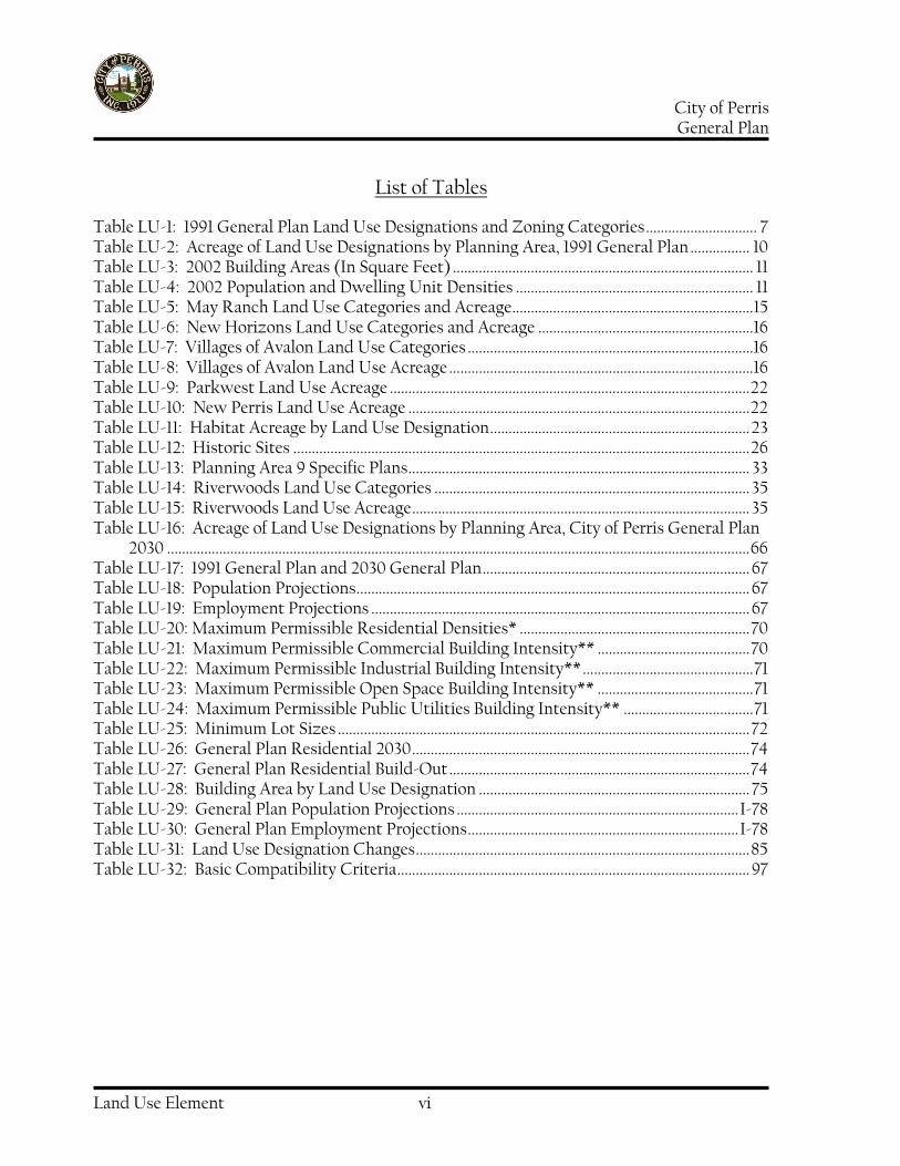
List of Tables
Table LU-1: 1991 General Plan Land Use Designations and Zoning Categories .............................. 7 Table LU-2: Acreage of Land Use Designations by Planning Area, 1991 General Plan ................ 10 Table LU-3: 2002 Building Areas (In Square Feet) ................................................................................. 11 Table LU-4: 2002 Population and Dwelling Unit Densities ................................................................ 11 Table LU-5: May Ranch Land Use Categories and Acreage................................................................. 15 Table LU-6: New Horizons Land Use Categories and Acreage ..........................................................16 Table LU-7: Villages of Avalon Land Use Categories .............................................................................16 Table LU-8: Villages of Avalon Land Use Acreage ..................................................................................16 Table LU-9: Parkwest Land Use Acreage ................................................................................................. 22 Table LU-10: New Perris Land Use Acreage ............................................................................................ 22 Table LU-11: Habitat Acreage by Land Use Designation ...................................................................... 23 Table LU-12: Historic Sites ........................................................................................................................... 26 Table LU-13: Planning Area 9 Specific Plans ............................................................................................ 33 Table LU-14: Riverwoods Land Use Categories ..................................................................................... 35 Table LU-15: Riverwoods Land Use Acreage ........................................................................................... 35 Table LU-16: Acreage of Land Use Designations by Planning Area, City of Perris General Plan
2030 ............................................................................................................................................................. 66 Table LU-17: 1991 General Plan and 2030 General Plan ........................................................................ 67 Table LU-18: Population Projections .......................................................................................................... 67 Table LU-19: Employment Projections ...................................................................................................... 67 Table LU-20: Maximum Permissible Residential Densities* .............................................................. 70 Table LU-21: Maximum Permissible Commercial Building Intensity** ......................................... 70 Table LU-22: Maximum Permissible Industrial Building Intensity** .............................................. 71 Table LU-23: Maximum Permissible Open Space Building Intensity** .......................................... 71 Table LU-24: Maximum Permissible Public Utilities Building Intensity** ................................... 71 Table LU-25: Minimum Lot Sizes ............................................................................................................... 72 Table LU-26: General Plan Residential 2030 ........................................................................................... 74 Table LU-27: General Plan Residential Build-Out ................................................................................. 74 Table LU-28: Building Area by Land Use Designation ......................................................................... 75 Table LU-29: General Plan Population Projections ............................................................................ I-78 Table LU-30: General Plan Employment Projections ......................................................................... I-78 Table LU-31: Land Use Designation Changes .......................................................................................... 85 Table LU-32: Basic Compatibility Criteria ............................................................................................... 97

City of Perris General Plan
Land Use Element vii
Page Left Intentionally Blank

City of Perris General Plan
Land Use Element 1
Introduction
The Land Use Element of the General Plan is a 30-year guide for local government decisions on growth, capital investment, and physical development in the City of Perris. The Land Use Element is comprised of four sections:
I. Existing Conditions provides a year 2003 inventory of the types and extent of land uses (residential, commercial, industrial, open space, etc.). Information on the general locations, quantities, and characteristics of existing development associated with these land uses is included.
II. Issues, Opportunities, and
Constraints reflects the community perspective on the strengths and shortcomings of the City of Perris in 2003. Those who live and work in Perris offered their visions for the future of the physical environment of the City. A synthesis of these inputs included in this section, together with Existing Conditions, is the foundation upon which the General Plan is built.
III. The Land Use Plan delineates the
locations and extent of each of the types of land uses envisioned in development over the 30-year time period associated with the General Plan. General guidelines for the size and intensity of future development are set forth and are the basis for changes in development standards in the City’s Zoning and Subdivision
Ordinances. The aggregate floor area for all new buildings, the numbers of new housing units, and increases in population and employment accompanying new development are estimated for the 30-year General Plan period.
IV. Each Strategy for Action section
sets forth the steps to be taken by the City of Perris to promote physical development consistent with the Land Use Plan. Changes to the Zoning Ordinance, the Subdivision Ordinance, and Redevelopment Plans, as well as future decisions on capital improvement plans, annual municipal budgets, and municipal department work programs are the primary means available to the City in promoting development described in the Land Use Element Land Use Plan.

City of Perris General Plan
Land Use Element 2
Existing Conditions
The Existing Conditions section of the Land Use Element provides an overview of land uses and patterns and intensities of development that characterize the built environment of the City of Perris in 2003. Existing Conditions describes this environment as the starting point of a 30-year strategy for managing and accommodating land use and development. Information in this section will inform the community and its leaders when setting development priorities, understanding necessary trade-offs, and choosing among alternatives. The City of Perris is divided into ten (10) Planning Areas (Exhibit LU-1) for purposes of analysis in Existing Conditions. Boundaries of some planning areas were drawn to reflect natural or manmade physical divisions: the I-215 Freeway and the San Jacinto River are examples of manmade and natural boundaries, respectively. Other planning areas encompass communities defined by similarities in land uses or development patterns: properties in Planning Area 6 are in Downtown Perris and include the bulk of the oldest structures and infrastructure in the City. Yet other planning areas are comprised of properties whose future development will be shaped by common constraints or opportunities: for example, large, undeveloped parcels covered by portions of the Multiple Species Habitat Conservation Plan corridor are joined as Planning Area 10. The Existing Conditions section begins with an overview of the ten Planning Areas. A summary table of land use characteristics of each Planning Area follows and provides
an “at-a-glance” view of the City. Lastly, an area-by-area analysis of existing conditions within each planning area is included with the Issues, Opportunities, and Constraints affecting how land use and development alternatives are formulated. Existing Conditions contains data on population, land area, amount of commercial and industrial building area, and number of dwelling units. A Flood Zone Overview depicts development limitations associated with periodic flooding in Perris.

City of Perris General Plan
Land Use Element 3
Exhibit LU-1: Planning Areas
City of Perris General Plan
Land Use Element 4
Overview of Planning-Areas
Planning Area 1: North Industrial
This area is generally made up of “industrial” land use designations and uses. While there are some residential uses in this area, the majority of land uses are non-residential. There are no schools or parks. This area is near March Global Port, and future land uses could include air-cargo support and air-cargo dependent businesses. Noise-sensitive uses that would be disturbed by air cargo or military plane overflights, such as residential development, should be discouraged. Heavy truck traffic can be expected in this area, affecting future roadway design and maintenance.
Planning Area 2: North Residential
This area is almost exclusively residential and is adjacent to the Lake Perris Recreation Area. Residential communities in the planning area were built in the late 1990’s and early 2000s pursuant to Specific Plans which incorporate complementary retail uses, schools, and parks and open space. The supporting infrastructure within the project areas was built concurrent with the housing.
Planning Area 3: Agricultural Conversion Area
This Planning Area consists of large tracts of land currently used for agriculture. Proximity to the Interstate 215 corridor suggests conversion of agricultural land,
over the long term, to uses that are compatible with surrounding commercial and industrial uses. Conversion could enhance the economy of the City by attracting new uses that complement the existing Lowe’s and Ross distribution centers and provide jobs for local residents. Nearby residential development may support some level of retail uses in this planning area. Infrastructure demands will depend on the ultimate uses of the land. Business park uses including product distribution centers will require upgraded roadways to accommodate significant numbers of large trucks. Roadway widths may require revisions and future roadway maintenance intervals may be shortened. Storm drains, water lines, and sanitary sewer lines will be needed as agricultural uses are discontinued.
Planning Area 4: Freeway Business Park
Agriculture is the primary land use in this area. As in Planning Area 3, the proximity of this property to Interstate 215 makes it a candidate for uses that are dependent upon freeway access and visibility. Business park development will be accompanied by an expansion of local job opportunities. Infrastructure construction and upgrades will be required and will include significant roadway improvements to accommodate significant increases in vehicular traffic. Development impact fees applicable in this area should be evaluated and revised to eliminate potential shortfalls in funding for required infrastructure. Planning Area 4 will contribute significantly to the daytime population of the City of Perris between the hours of 7 AM to 6 PM, Monday through Friday.

City of Perris General Plan
Land Use Element 5
Planning Area 5: Central Core
This area includes significant residential development and the primary retail/commercial centers in the City. Centers include grocery stores and retail outlets providing both convenience goods and durable goods for residents from both within and outside of the planning area. None of the other planning areas include a similar concentration of retail establishments. Residents of Perris must do their shopping here or go outside the City. This Planning Area also includes the undeveloped Parkwest and New Perris Specific Plans. These Specific Plans anticipate a mix of residential, office, and commercial uses.
Planning Area 6: Downtown Specific Plan Area
City Hall, the Community Center and Gymnasium, the Senior Center, and the proposed Metrolink Station are all within this Planning Area, which functions as the City’s civic center. Revitalization plans call for the development of new retail opportunities and renovation of historic buildings to create a destination for residents from all parts of the City as well as outside of Perris. Aging infrastructure including water and sanitary sewer lines that comprise the majority of the City’s municipal water district are of concern. Anticipated increases in vehicle trips and parking demand associated with downtown revitalization and the future development of a Metrolink station need to be addressed.
Planning Area- 7: Westside Residential
This Planning Area is located on the western edge of the city and is primarily made up of residential uses. The infrastructure in this area is aging and in need of repair. While the Rimrock Wilderness Area in the northwest corner of the Planning Area provides passive recreational uses, there is a need for active parkland and sports fields for use by the residents. Minimal retail commercial development exists in this Planning Area.
Planning Area-8: Perris Valley Airport
The Perris Valley Airport is the most prominent use in the area. General and Light Industrial land use designations predominate. Planning Area 8 also includes the Orange Empire Railway Museum. Other uses include a transfer station for refuse and recycling operations, boat sales lots, and auto repair shops. Two portions of the Green Valley Specific Plan extend into the area from across the San Jacinto River Channel and are designated for industrial uses. Portions of the undeveloped New Perris Specific Plan also extend into Planning Area 8 from Planning Area 5.
Planning Area 9: South Specific Plans
The Riverglen Specific Plan together with the Green Valley Specific Plan make-up the majority of this planning area. Public and quasi-public land uses include an Eastern Municipal Water District sewage treatment facility. Community Commercial land use designations

City of Perris General Plan
Land Use Element 6
surround the existing Case Road interchange on Interstate 215. An additional interchange at Ellis Avenue has been approved with construction dependent upon compliance with criteria in the Multiple Species Habitat Conservation Plan. This area may provide opportunities for retail commercial and business park uses that draw upon a regional market made accessible by the I-215 Freeway. The existing Specific Plans allow for a mixture of business and residential uses that are compatible with surrounding land use designations.
Planning Area 10: South Residential
This Planning Area is characterized by low-density residential uses and open space. Future development will require significant infrastructure improvements. Emergency services response times need to be addressed because of the distance to existing police and fire facilities, and because of the impact of deteriorated roadways on those response times. New facilities for fire and police services may need to be built to accommodate new growth in this area. The nearest future school site is in the Riverwoods Specific Plan area, across the river to the north of the Planning Area.
Data Summary
The 1991 General Plan Land Use designations and corresponding Zoning Categories are listed in Table LU-1, and provide the starting point from which the Perris General Plan 2030 evolved. Table LU-2 lists acreages of the 1991 Perris General Plan Land Use Categories, City-wide, by Planning Area. The table illustrates the distribution of various land
uses by Planning Area, and as a percentage of the City as a whole. Table LU-3 provides building area information, and Table LU-4 provides residential and population density information.

City of Perris General Plan
Land Use Element 7
Table LU-1: 1991 General Plan Land Use Designations and Zoning Categories
1991 General Plan
Designation
Zoning Designation
Maximum Permissible
Intensity/Density Other Allowed Uses
Residential
Rural Residential/ Agriculture
RR/A 0.0-2.0 DU/AC* Church, school, child care
Residential 4 SFD
R4
2.0-4.0 DU/AC Church, school, child care
Residential 7 SFD, duplex, condominium, town home
R7 4.0-7.0 DU/AC Church, school, child care
Residential 14 MFD
R14 7.0-14.0 DU/AC Church, school, child care
Residential 22 MFD
R22 14.0-22.0 DU/AC Church, school, child care, congregate care
No corresponding category
R-4 Mobile-home Park
Projects shall not exceed an average 10 DU/AC; Minimum park shall be no less than 5 acres
Mobile home parks, trailer parks, accessory uses and buildings, recreational vehicle parks.
No corresponding category
R-5 Mobile-home Subdivision
Minimum lot size 6,000 SF
Mobile homes, manufactured homes and factory built homes for single family residential use, public utilities and public service facilities, recreational facilities for the use of lot owners, temporary real estate tract offices
Commercial
Commercial Neighborhood (CN)
CN 0.50:1 FAR** Business offices, clothing stores, food and drug stores, furniture and appliance stores, hardware stores, restaurants, specialty retail, sporting goods <50,000 s.f.
*DU/AC=Dwelling Units Per Acre **FAR= Floor Area Ratio (Floor Area of Building ÷ Lot Area)

City of Perris General Plan
Land Use Element 8
1991 General Plan
Designation
Zoning Designation
Maximum Permissible
Intensity/Density Other Allowed Uses
Continued from previous page
Commercial Community (CC)
CC 0.75:1 FAR Professional offices, department stores, discount stores, furniture/appliance outlet. Home improvement centers, Entertainment centers, sub regional/ regional shopping centers
Office
Professional Office (PO)
PO 1.0:1 FAR Corporate offices, cultural and community facilities, financial institutions, legal and medical services
Industrial
Business Park (BP)
BP 0.75:1 FAR Business/professional offices, light manufacturing, storage, warehousing/ distribution, wholesaling, large-scale warehouse retail, automobile dealerships, service commercial, public uses
Light Industrial (LI)
LI 0.75:1 FAR Manufacturing, research, warehousing/ distributing, assembly of non-hazardous products and materials, retail related to manufacturing
General Industrial (GL)
GI 0.75:1 FAR Warehousing and distribution facilities, industrial
Other
Public/Semi-Public Facilities/ Utilities (PF)
P 0.5:1 FAR Community recreation facilities, equestrian centers, golf courses/driving ranges, indoor/outdoor athletic facilities, public parklands

City of Perris General Plan
Land Use Element 9
1991 General Plan
Designation
Zoning Designation
Maximum Permissible
Intensity/Density Other Allowed Uses
Parks/Recreation/ Open Space (OS)
OS 0.25:1 FAR Schools, government administrative offices and facilities, public utilities, institutes of higher learning, religious institutions, libraries, hospitals, cultural recreational activities, major transportation corridors
Continued from previous page
No corresponding category
A1 Light Agriculture
Any use permitted in R7 zone, agricultural operations, water, electricity facilities, way stations of passenger transport facilities, recreational and educational uses, RV park, convalescent rest home
No corresponding category
Downtown Design Overlay
Same as any residential or commercial zone, consistent with the Central Redevelopment Plan
*DU/AC=Dwelling Units Per Acre **FAR= Floor Area Ratio (Floor Area of Building ÷ Lot Area)

City of Perris General Plan
Land Use Element 10
Table LU-2: Acreage of Land Use Designations by Planning Area, 1991 General Plan
1991 General Plan Land Use Designation
PA1 PA2 PA3 PA4 PA5 PA6 PA7 PA8 PA9 PA10 Total % of City
Residential
RR/A 62 101 0 0 169 21 319 0 0 455 1,127 6.1% R4 269 12 0 0 645 0 762 0 0 279 1,967 10.7% R7 145 215 0 0 543 158 650 0 364 1,236 3,311 18% R14 0 578 22 0 972 125 28 0 830 32 2,587 14% R22 0 40 0 0 16 0 0 0 49 0 105 0.6%
Commercial
CN 11 4 16 0 23 33 0 9 7 0 103 0.6% CC 316 76 207 261 437 52 113 55 374 10 1,901 10.3%
Industrial
BP 127 0 0 392 36 0 0 0 64 0 619 3.4% LI 528 0 1,062 134 0 93 0 587 25 0 2,429 13.2% GI 431 0 0 0 0 0 0 504 0 0 935 5.1%
Office
PO 0 0 0 0 83 14 0 0 0 0 97 0.5%
Other
P 27 1 46 10 284 67 79 160 500 153 1,327 7.2% OS 9 75 68 0 231 17 385 7 98 1,029 1,919 10.4%
Totals 1,925 1,102 1,421 797 3,439 580 2,336 1,322 2,311 3,194 18,427 % of City 10.4% 6% 7.7% 4.3% 18.7% 3.1% 12.7% 7.2% 12.5% 17.3% 100%

City of Perris General Plan
Land Use Element 11
Table LU-3: 2002 Building Areas (In Square Feet)
Source: City of Perris Planning Department, GIS data
Table LU-4: 2002 Population and Dwelling Unit Densities
Planning Area
Acres Population People/Acre* Dwelling
Units Dwelling
Units/Acre*
1 1,925 552 0.3 187 .10 2 1,102 2,230 2.02 633 .57 3 1,421 625 0.44 374 .26 4 797 199 0.25 28 .04 5 3,439 21,903 6.37 6,029 1.75 6 580 4,387 7.56 1,148 1.97 7 2,331 6,033 2.59 1,765 .76 8 1,322 32 0.02 9 .007 9 2,311 7 0.003 5 .002 10 3,194 79 0.02 26 .008
Total 18,422 36,047 10,204 City-Wide Average
1.96 0.55
Source: City of Perris, Planning Department; US Census, 2000 *Acreage component includes undeveloped land
Planning Areas
Business Park
Commercial Industrial
1 0 19,340 380,694 2 0 0 0 3 0 132,962 1,705,681 4 117,159 289,503 499,678 5 0 288,798 0 6 0 564,693 331,645 7 0 85,200 0
8 0 150,600 497,896 9 0 7,000 35,000
10 0 0 0
Totals 117,159 1,538,096 3,118,949
City of Perris General Plan
Land Use Element 12
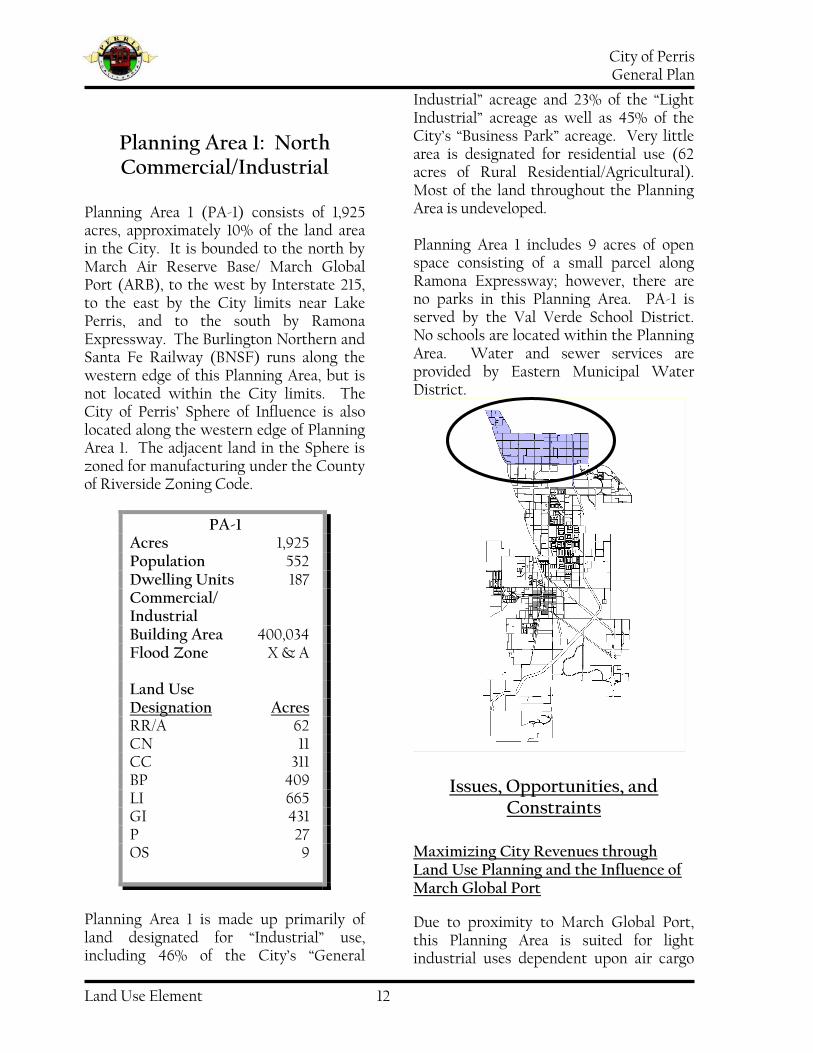
PA-1 Acres 1,925 Population 552 Dwelling Units 187 Commercial/ Industrial Building Area 400,034 Flood Zone X & A Land Use Designation Acres RR/A 62 CN 11 CC 311 BP 409 LI 665 GI 431 P 27 OS 9
Planning Area 1: North Commercial/Industrial
Planning Area 1 (PA-1) consists of 1,925 acres, approximately 10% of the land area in the City. It is bounded to the north by March Air Reserve Base/ March Global Port (ARB), to the west by Interstate 215, to the east by the City limits near Lake Perris, and to the south by Ramona Expressway. The Burlington Northern and Santa Fe Railway (BNSF) runs along the western edge of this Planning Area, but is not located within the City limits. The City of Perris’ Sphere of Influence is also located along the western edge of Planning Area 1. The adjacent land in the Sphere is zoned for manufacturing under the County of Riverside Zoning Code.
Planning Area 1 is made up primarily of land designated for “Industrial” use, including 46% of the City’s “General
Industrial” acreage and 23% of the “Light Industrial” acreage as well as 45% of the City’s “Business Park” acreage. Very little area is designated for residential use (62 acres of Rural Residential/Agricultural). Most of the land throughout the Planning Area is undeveloped. Planning Area 1 includes 9 acres of open space consisting of a small parcel along Ramona Expressway; however, there are no parks in this Planning Area. PA-1 is served by the Val Verde School District. No schools are located within the Planning Area. Water and sewer services are provided by Eastern Municipal Water District.
Issues, Opportunities, and Constraints
Maximizing City Revenues through Land Use Planning and the Influence of March Global Port
Due to proximity to March Global Port, this Planning Area is suited for light industrial uses dependent upon air cargo

City of Perris General Plan
Land Use Element 13
transportation. Future infrastructure and development should be planned to accommodate cargo airport-related land uses. Such uses bring jobs and accompanying increases in total disposable income, ultimately supporting retail uses that generate sales tax revenue to the City.
Vacant Land
The bulk of properties in this Planning Area (1,470 acres or 76% of the land in this Planning Area) are vacant. Nine property owners, whose holdings consist of 25 or more contiguous acres each, control 658 acres comprising more than 1/3 of the land in this Planning Area.
Redevelopment Agency Areas
Fifty-two percent (1,003 acres) of Planning Area 1 is included in Redevelopment Project Area 2. The City of Perris has three redevelopment project areas which were determined to have blighting conditions at the time of adoption of the Redevelopment Plans. Redevelopment provides for needed public improvements by encouraging rehabilitation and repair of deteriorated structures, allows for land assembly, and promotes development in accordance with the General Plan.
Accident Potential Zone
Portions of Planning Area 1 are included within March Air Reserve Base Accident Potential Zones I and II and the Clear Zone. These impact zones restrict the types and intensities of uses on some properties within the Planning Area to mostly non-residential, low-occupancy uses.
Infrastructure Development
Most of the infrastructure required to support development, such as roads, sewers and storm drains, is lacking. This area will require substantial infrastructure funding and construction concurrent with new development.
Service Delivery
This Planning Area is at the northern edge of the City. There are no police or fire stations near this planning area, resulting in increased emergency services response times.

City of Perris General Plan
Land Use Element 14
PA-2 Acres 1102 Population 2230 Units 633 Commercial/ Industrial Building Area 0 sq. ft. Flood Zone A, X and X500 Land Use Designation Acres RR/A 102 R4 12 R7 215 R14 578 R 22 40 CN 4 CC 76 P 2 OS/Park 74
Planning Area 2: North Residential
Planning Area 2 represents approximately 6% of the total City land area. It is a short distance southeast from the Lake Perris Recreation Area and bordered by the Ramona Expressway to the north and east, Walnut Avenue and Placentia Avenue to the south, and the Perris Valley Storm Channel on the west. PA-2 consists mainly of planned residential communities. The communities include land set aside for schools, parks, and neighborhood commercial uses. The communities were designed using specific
plans and include May Ranch, New Horizons, and Villages of Avalon. Construction on the homes in the area began in the mid-1990s. Infrastructure was
constructed in conjunction with residential development. The Eastern Municipal Water District provides water and sewer services to the May Ranch and New Horizons communities. A separate district was established specifically to provide potable water for the Villages of Avalon. The Eastern Municipal Water District, however, provides sanitary sewer service to the Villages of Avalon. PA-2 falls within the boundaries of the Val Verde Unified School District. The Avalon Elementary School is slated for development within the Villages of Avalon Specific Plan area at the southeast corner of Rider Street and Bradley.
Issues, Opportunities, and Constraints
Existing Housing
The planned residential developments in PA-2 are within Specific Plan areas that

City of Perris General Plan
Land Use Element 15
allow for 85% of the lots to be less than 7,200 square feet.
Parks
Although there are areas of open space included within the planned communities of PA-2, the amount of land set forth for active parks, in relation to the number of planned residential units, is inadequate.
Service Delivery
The Planning Area is located in the north part of the City at some distance from police and fire stations. Emergency services response times are increased accordingly. A fee program linked to the residential development has been adopted to finance a new fire station.
Specific Plans
May Ranch - 744 acres May Ranch extends north to south over two-thirds of Planning Area 2, and is the City’s largest residential planned community with 3,000 residential units slated to occupy 623 acres. With the exception of the areas planned for high density/multi-family uses, the specific plan’s residential land use designations are based on lot sizes that range from 4,000 to 20,000 square feet. Future development of May Ranch also includes 77 acres designated for commercial development, and 24 acres for parkland. There are also 14 acres of open space where the Colorado River Aqueduct passes through the community.
Table LU-5: May Ranch Land Use Categories and Acreage
May Ranch Specific Plan
GP Designation
SP Designation
Acreage
RR/A R-20000 118
R 4 R-10000 30
R 4 R-7000 64
R 7 R-5400 113
R 7 R-5000 108
R 7 R-4500 50
R 14 R-4000 115
R 22 Multi-Family 25
CC Commercial 77
OS/ Rec/Park Public Parks 24 Drainage Channel 6
MWD Aqueduct 14
Total 744
New Horizons – 135 acres Located in the middle of Planning Area 2, immediately to the east of the Perris Valley Storm Drain Channel and bordered to the north, south and east by May Ranch, the New Horizons Specific Plan includes 805 residential units on 126 acres. Residential densities within this Specific Plan area are identified as “planning areas” defined by lot sizes and permissible densities. Lot sizes range from 5,000 to 6,000 square feet. One of the five residential designations allows for high density/multi-family development. The only open space designation within the New Horizons Specific Plan consists of 9.1 acres of the Colorado River Aqueduct that runs east to west in the area.

City of Perris General Plan
Land Use Element 16
Table LU-6: New Horizons Land Use Categories and Acreage
Land Use Designation
SP Designation
Acreage
R 7 PA-1 32.3 R 7 PA-3 13.3 R 7 PA-5 28.3 R 7 PA-6 9.1 R 22 PA-2 25.6 OS PA-4 26.4 OS/Rec/Park Public Parks
Total 135
Villages of Avalon – 262 acres The Villages of Avalon Specific Plan encompasses 262 acres in the northeast corner of PA-2, and is the community nearest the Lake Perris Recreation Area. The community is planned for single-family residential lots ranging from 3,600 to 5,000 square feet. The specific plan includes an elementary school, 12 acres of open space included on the aqueduct easement, a 2-acre recreation facility owned by the homeowners association, a water supply tank, and approximately 3 acres for neighborhood commercial uses.
Table LU-7: Villages of Avalon Land Use Categories
Land Use Designation
SP Designation
R 7 5,000 Residential R 7 4,000 Residential
R 7 3,600 Residential OS/ Rec/Park Parks Parks Public Parks
Table LU-8: Villages of Avalon Land Use Acreage
Land Use Designation
Acreage
5,000 Residential 41.29 4,000 Residential 113.65 3,600 Residential 33.83 Water Tank 1.06 Neighborhood Comm. 2.84 School Site(s) 28.23 HOA Recreation Facility 1.96 Parks 12.23 Circulation 27.60
Total 262.69
Sphere of Influence A Sphere of Influence (SOI) is the area outside of and adjacent to a city's border that has been identified by the County Local Agency Formation Commission as a future logical extension of the city's jurisdiction. The County of Riverside has land use authority over City Sphere areas, but typically must include the City in making land use decisions within the Sphere. The City’s Sphere of Influence includes an area adjacent to and south of PA-2. The County of Riverside currently designates this area for residential uses. Only scattered residential development exists in this otherwise undeveloped area.

City of Perris General Plan
Land Use Element 17
Planning Area 3: Agricultural Conversion Area
Planning Area 3 is in the northern part of the City and is bordered by the Ramona Expressway to the north, Interstate 215 to the west, the Perris Valley Storm Channel to the east and Walnut and Orange Avenues to the south. The BNSF railway runs along the western edge of the Planning Area. The Planning Area consists of large tracts of agricultural-zoned land that represents 42% of the city’s agricultural zoning, although there is no agricultural land use designation under the 1991 General Plan. The largest land use category within the Planning Area is Light Industrial. Due to the Planning Area’s proximity to Interstate 215, the cargo airport, other industrial and commercial
land uses, and an existing rail line along the western edge, future development should be planned to expand industrial and commercial opportunities. This Planning Area contains 288 acres of Redevelopment Area 3.
Served by the Val Verde Unified School District, Planning Area 3 is home to the school district’s main office located on Morgan Street. Val Verde High School is located across the street from the District Office. The Eastern Municipal Water District (EMWD) provides water and sewer service. There are no parks in this Planning Area. The Colorado River Aqueduct runs underground, east-west, and represents the Planning Area’s only Open Space. The Sphere of Influence adjoins the western edge of Planning Area 3 and is zoned for Manufacturing under the County of Riverside Zoning Code. Planning Area 3 contains property held by 11 landowners each of whom controls more than 25 contiguous acres. As a group, they own 310 acres, about 22% of the Planning Area. Undeveloped land in this Planning Area totals 352 acres, or 25% of the Area.
PA-3 Acres 1,421 Population 625 Units 374 Commercial/ Industrial Building Area 1,848,643 Flood Zone A, X and X500 Land Use Designation Acres R14 22 CN 5 CC 207 LI 1,073 P 46 OS 68

City of Perris General Plan
Land Use Element 18
Issues, Opportunities, and Constraints
Maximizing City Revenues through Land Use Planning
This area contains land currently under agricultural cultivation. While the zoning code includes an Agricultural zoning designation, there is no corresponding agricultural land use designation in the 1991 General Plan. These agricultural lands could be converted to uses that generate revenue and create jobs within the City.
Infrastructure
This area is currently used for agriculture and needs intensive infrastructure development, from storm drains and sewers to any necessary police and fire facilities to serve the area. Additionally, roads need to be developed to support heavy truck traffic.
Vacant Land
One-fourth of the land in this Planning Area is vacant. Additionally, one-fourth of the Planning Area is currently in agricultural production.
March Global Port
Due to the proximity of PA-3 to March Global Port and the growth of distribution and freight services in the region, future infrastructure and development should be planned to accommodate and maximize the benefits from cargo airport-related land uses. Current uses in the Planning Area, such as the Lowe’s and Ross distribution centers are examples of the types of uses well suited for this planning area. The facilities
are close to rail, air-cargo, and the interstate highway system.
Single-Owner Land Holdings
Due to the large amount of land held by 11 property owners in the Planning Area (roughly 22% of the Planning Area), communication with these property owners is key to jointly developing objectives that meet both the City’s and owners goals for future growth and development as land use changes are considered. In addition, changing land use designations for land currently under cultivation could allow an increase in retail and commercial development, which in turn contributes to increased revenues to the city to the extent that future residential development and demand for non-retail commercial development warrant. The terms of Williamson Act agreements with current land holders, the reluctance of those land holders to increase their tax burden, or the reluctance to sell land which may have been held within a family for several generations need to be considered.
Interstate 215 Corridor
This Planning Area is located along the Interstate 215 corridor. Commercial and light industrial uses may benefit from freeway visibility and access.
Accident Potential Zone II
The Accident Potential Zone for March Air Reserve Base is configured to decrease the likelihood of damage to people or property from any potential aircraft accidents. A portion of this zone lies within Planning Area 3. This impact zone affects potential land uses within the Planning Area.

City of Perris General Plan
Land Use Element 19
Planning Area 4: Freeway Business Park
Planning Area 4 consists of 797 acres and is bordered by Interstate 215 to the west, by Rider Street to the north, Perris Boulevard to the east and Nuevo Road on the south. The BNSF rail line also runs along the western edge of PA-4. Representing approximately 4% of the City’s total area it contains over 35% of the City’s existing Business Park land use designation. With Wal-Mart, a theater and other commercial entities, this planning area generates much of the City’s sales tax revenues. The Val Verde Unified School district serves most of Planning Area 4 and the Val Verde High School and Val Verde Elementary School are both located here. The Perris Elementary School District serves the southern tip of the Planning
Area, located south of Citrus Avenue. The Eastern Municipal Water District provides water and sewer service.
Issues, Opportunities, and Constraints
Maximizing City Revenues through Land Use Planning
The proximity of Planning Area 4 to I-215 makes it ideal for freeway-oriented land uses. New Business Park and freeway-oriented business can create additional employment opportunities, resulting in a larger customer base to support retail outlets, restaurants, and other service-oriented businesses that serve the before-during-after work needs of workers and professionals.
Vacant and/or Agricultural Land
Although predominantly designated for Business Park, Light Industrial and Commercial uses, a majority of land in the Planning Area is still under agricultural production. The agricultural land uses
include 343 acres currently under Williamson Act contract, which provides tax incentives for lands kept under agricultural production for specific periods
PA-4 Acres 797 Population 199 Units 28 Commercial/ Industrial Building Area 906,340 Flood Zone X Land Use Designation Acres R22 76 CC 245 BP 316 LI 150 P 10
City of Perris General Plan
Land Use Element 20
of time. Approximately 25% of the land in PA-4 is vacant and not given to productive use.
Development Fee Program
The area can benefit from a development fee program that will pay for road improvements that will make business operation in this Planning Area more appealing.
Redevelopment Agency Areas
Planning Area 4 includes land in two of the City’s Redevelopment Agency Areas.
Sphere of Influence
The Sphere of Influence located to the west of Planning Area 4 encompasses the area known as Mead Valley. The land is designated for a variety of land uses including manufacturing, agricultural and residential uses.

City of Perris General Plan
Land Use Element 21
Planning Area 5: Central Core
This Planning Area is bounded by Perris Blvd. and Interstate 215 to the west and southwest, the city limits to the east, and segments of Rider, Placentia, and Orange Avenues to the north. Planning Area 5 includes the two specific plan areas, Parkwest and a portion of the New Perris Specific Plan. PA-5 contains 4% of the land designated R22 in the City, the most dense residential land use allowed. The Planning Area also contains 41% of all R14 designated land,
the second most dense zoning allowed. Both R22 and R14 are intended for multiple-family dwellings. This Planning Area contains 22.4% of the Neighborhood Commercial and 23% of the Community Commercial land use designations within the City.
The Eastern Municipal Water District (EMWD) provides water and sewer service to a majority of this Planning Area. The City of Perris Sewer District and City of Perris Water District each serve an area generally bounded by Evans Road, Ruby Drive, Interstate 215 and Nuevo Road. The south portion of this planning area is largely undeveloped, with 769 acres of vacant land. The Parkwest and New Perris Specific Plans comprise the bulk of large, single-owner land holdings in Planning Area 5. Nineteen landowners each own more than 25 contiguous acres, with combined holdings of 1,813 acres (53% of the Planning Area).
One part of the City’s sphere of influence borders the northern edge of the Planning Area and is zoned residential by the County of Riverside. The Perris Valley Drainage Channel, which runs north-south, bisects the Planning Area. The San Jacinto River runs through the south portion in the New Perris Specific Plan area.
PA-5 Acres 3,439 Population 22,045 Units 6,029 Commercial/ Industrial Building Area 288,798 Flood Zone A, X and X500 Land Use Designation Acres RR/A 169 R4 645 R7 604 R14 972 R22 27 CN 23 CC 342 BP 36 PO 106 P 284 OS 231

City of Perris General Plan
Land Use Element 22
Three school districts serve Planning Area 5. Val Verde serves all areas north of Citrus Avenue, and provides both elementary and secondary education. Perris Elementary School District and Perris Union High School District serve the areas south of Citrus. Palms Elementary School and Perris High School are located within this Planning Area,
Table LU-9: Parkwest Land Use Acreage
The Specific Plan areas call for residential, commercial, open space, and parkland development. Below are charts outlining the Specific Plan areas.
Issues, Opportunities, & Constraints
Maximizing City Revenues through Land Use Planning
The existing land use designations create an opportunity to place additional commercial and retail establishments in this area. Increased retail uses provide durable and convenience goods for residents so that sales tax revenues are not lost to nearby jurisdictions.
Housing
The housing stock in Perris is viewed as aged and in need of repair. In addition, there is a perception that there are too many small-lot homes and too few move-up opportunities in the City.
Table LU-10: New Perris Land Use Acreage
Land Prices
The price of land is reasonably affordable, and this could create opportunities for homes with larger lot sizes such as a 7,200 s.f. minimum, and move-up opportunities for people already living in Perris.
Open Space, Parks and Recreation Facilities
There are 3 existing parks totaling 25.9 acres: Paragon Park-14.1 Acres 2 lighted tennis courts, 2 handball courts, lighted basketball court, play structure, shelter, portable restrooms, parking lot,
Land Use Designation Acreage
R-5000 92 R-6000 151 R-7000 57 MF (Senior) 19 Commercial 32 Parks 20 Water Basins 6 Open Space/Retention 150 Circulation 40
Total 567 Total Residential
Units 2,027
Land Use Designation
Acreage
Single Family Residential
37
Research & Development
40
Commercial 24 Office/Commercial 55 Residential 37 Golf Course 171 Hotel 12
Total 376 Total Residential
Units 114
*Part of the New Perris Specific Plan is in Planning Area 8. These figures reflect only those portions within Planning Area 5

City of Perris General Plan
Land Use Element 23
picnic tables, benches, barbeque area, open space Copper Creek Park-7.39 Acres Picnic tables, benches, shelter, barbeque area, play structure, open space Bob Long Memorial Ballpark-4.41 Acres Amenities include 2 baseball fields, 1 T-ball field, bleachers, lights, covered dugouts, restrooms, snack bar
Redevelopment Agency Areas
Portions of Redevelopment Areas 1, 2, and 3 comprise 774 acres (22%) of the Planning Area.
Future Residential Development
Impact fees levied on new development do not fully fund new police or fire facilities or other infrastructure requirements. New housing development should be subject to fees adequate to provide upgraded or expanded facilities for police and fire services as well as the roads, drains, sewers, and other infrastructure necessary to serve the new development.
Multiple Species Habitat Conservation Plan
The County of Riverside has adopted a Multiple Species Habitat Conservation Plan (MSHCP) that designates land to be set aside for habitat conservation. Development of land within the Plan boundaries, which encompasses 1,300 acres, will be limited. Affected lands will fall into two area boundaries—Reserve Area and Criteria Area. The Reserve Area properties will ultimately be acquired to provide habitat area, while property within the Criteria Area may be developed, but with limitations that conserve existing habitat on those properties. All development plans will be subject to specialized review procedures.
The following development is impacted by the MSHCP Reserve area:
Table LU-11: Habitat Acreage by Land Use Designation
Lack of Parkland
This Planning Area has the largest number of parks within the City. The City would like to increase the number and quality of its parks and trails. There are not enough parks to satisfy the demands of user groups and the community at large. There is also a desire to complete a trail system throughout the City that connects to regional or Countywide trail systems. Future parklands proposed within the Specific Plan Areas are not adequate to meet the needs of the City’s residents. The New Perris Specific Plan does not include parkland. Consistent with accepted standards, 22 acres of active parkland should be provided in the Planning Area
New Perris Specific Plan
Residential 37 acres Commercial 6 acres R & D 40 acres Office/Commercial 55 acres Golf Course 171 acres Hotel 12 acres Circulation 54 acres
Future Habitat 375 acres
Parkwest Specific Plan
Residential 70 acres Commercial 12 acres Open Space/Retention 52 acres
Future Habitat 134 acres
City of Perris General Plan
Land Use Element 24
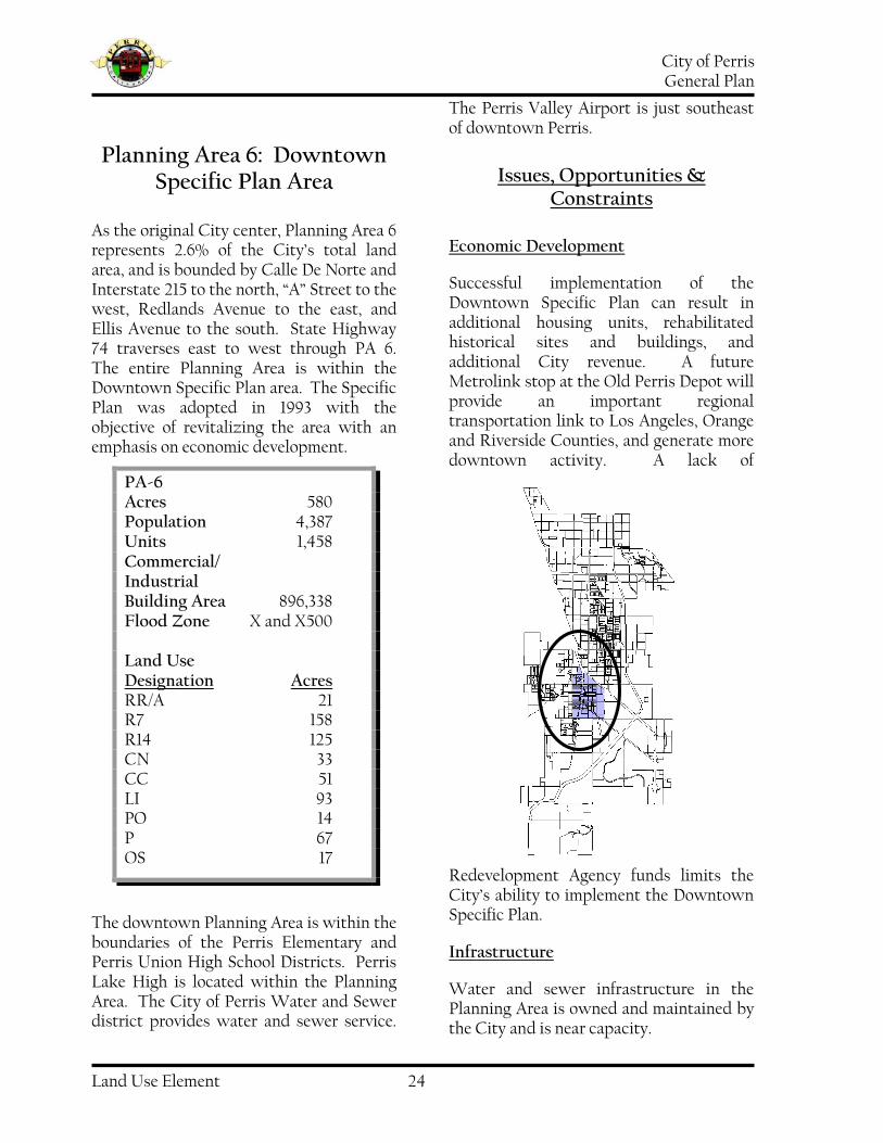
Planning Area 6: Downtown Specific Plan Area
As the original City center, Planning Area 6 represents 2.6% of the City’s total land area, and is bounded by Calle De Norte and Interstate 215 to the north, “A” Street to the west, Redlands Avenue to the east, and Ellis Avenue to the south. State Highway 74 traverses east to west through PA 6. The entire Planning Area is within the Downtown Specific Plan area. The Specific Plan was adopted in 1993 with the objective of revitalizing the area with an emphasis on economic development.
The downtown Planning Area is within the boundaries of the Perris Elementary and Perris Union High School Districts. Perris Lake High is located within the Planning Area. The City of Perris Water and Sewer district provides water and sewer service.
The Perris Valley Airport is just southeast of downtown Perris.
Issues, Opportunities & Constraints
Economic Development
Successful implementation of the Downtown Specific Plan can result in additional housing units, rehabilitated historical sites and buildings, and additional City revenue. A future Metrolink stop at the Old Perris Depot will provide an important regional transportation link to Los Angeles, Orange and Riverside Counties, and generate more downtown activity. A lack of
Redevelopment Agency funds limits the City’s ability to implement the Downtown Specific Plan.
Infrastructure
Water and sewer infrastructure in the Planning Area is owned and maintained by the City and is near capacity.
PA-6 Acres 580 Population 4,387 Units 1,458 Commercial/ Industrial Building Area 896,338 Flood Zone X and X500 Land Use Designation Acres RR/A 21 R7 158 R14 125 CN 33 CC 51 LI 93 PO 14 P 67 OS 17

City of Perris General Plan
Land Use Element 25
Open Space, Parks and Recreation Facilities
Banta Beatty Senior Citizen Park 1.16 acres at 118 N. “D” Street. Facilities: parking lot, Senior Citizen’s Center, barbeque area, benches, picnic tables. Civic Center Complex 6.41 acres at 101 N. “D” Street Facilities: Bob Glass Gymnasium and Community Rooms, full basketball court, stage, bleachers, restrooms, meeting/activity room, kitchen facilities, Statler Youth Center, game/activity/TV room. Foss Field Park 4.95 acres at 138/120 N. Perris Blvd. Facilities: 1 lighted baseball field, 1 lighted basketball court, 1 sand volleyball court, play structure, restrooms, shelters, picnic tables, benches, barbeques, 2 lighted tennis courts, parking. Howard Schlundt Park 0.5 acres at 150 E. 4th Street Facilities: benches. Russell Stewart Park 1.5 acres at 160 E. 1st Street Facilities: benches & gazebo. Rotary Park 8 acres at “A” Street and Ellis Ave. Facilities: play equipment, picnic areas, improved sports fields. This park is a joint use facility with 3.4 acres of city-owned property, while the remainder of the park is school-owned property.
Points of Interest & Historic Sites
The Perris Valley Historical Association and the Riverside County Office of Historic Preservation has identified fifty-seven historic sites and structures within the City of Perris. All of these structures exist
in the Downtown area and are listed in Table LU-12. The Santa Fe Depot was listed in 1994 on the National Register of Historic Places and is currently home to Perris Valley Historical Museum. The Southern Hotel is listed on the State list of historic places.
Redevelopment Agency Areas
This Planning Area includes property within one or more Redevelopment Agency Areas.

City of Perris General Plan
Land Use Element 26
Table LU-12: Historic Sites
Building/Site Location
Santa Fe Depot/ Perris Valley Historical Museum 120 W. 4th Smith Brothers Potato Shed 3rd and “C” Streets Perris City Hall, Gymnasium, Police Department 101 N. “D” Street Hook Garage/Perris Garage 225 S. “D” Street Perris Theatre 295 S. “D” Street Sharpless-Coudures Building/ Perris Hotel 4th and Streets Nance Building 318 S. “D” Street Mapes General Store SE Corner 4th and “D” Street JW McCanna Home 155 E. 4th Street Bell A. McCanna Home 149 E. 4th Street Mapes-Cummins Home 196 E. 6th Street First Congregational Church 177 E. 6th Street Formerly Brun's Fashion Livery Stable 600 S. "D" Street Formerly Reynolds Hardware & Plumbing Co. 566 S. "D" Street Hook Brothers Store 505 S. "D" Street Mission Inn Building 502 S. "D" Street Southern Hotel 445 S. “D” Street Lung Sing’s Club House Café SE Corner 4th and “D” Street Formerly Bank of Perris 400 S. “D” Street Formerly Robertine Hotel and Boarding House 504 and 510 “C” Street Holloway Home 230 W. 7th Street A.W. Hook Home 223 W. 7th Street Merritt/C Kirkpatrick Home 239 W. 7th Street W.A. Morrison Home 233 W. 4th Street E.E. Morrison Home 239 W. 4th Street Thompson Home 191 W. 7th Street J.F. Hook/Stewart Home 650 Park Avenue Shelton/Mitchler/Stewart Home 496 W. 4th Street Formerly Stationmaster’s Home 328 W. 5th Street Austin/Reese Home 306 W. 5th Street Boardman Home 270 W. 5th Street A.W. Metz/Homer Smith Home 400 S. “B” Street C.R. Stewart Home 326 W. 4th Street T. Kirkpatrick Home 251 W. 4th Street Reynold’s Home 246 W. 4th Street Railway/Pinacate Station 2201 S. “A” Street Rock House 246 Lomita Drive Blue and White Market 329 S. “D” Street John Reynolds/Kingston Home SE corner 4th & Perris Blvd. Harford/Sheldon/Stewart Home 240 W. 4th Street Hook and Oaks Building 7th and “D” Street Van Dodson Ford Dealership 234 South “D” Street Site of the Old Perris Ice House NW 2nd & “D” Street

City of Perris General Plan
Land Use Element 27
Building/Site Location
Continued from previous page Russell J. Stewart Park SW San Jacinto Ave & Perris Blvd. Site of Evelyn Hall 319 South “D” Street Masonic Lodge 321 South “D” Street Open Air Market 325 South “D” Street Dora Nelson African - American History Museum 316 E. Seventh Street Site of Akin Homestead 147 East Fourth Street

City of Perris General Plan
Land Use Element 28
Planning Area 7: Westside Residential
Planning Area 7 makes up 12.6% of the City’s land area and is bounded by Nuevo Road to the north, the City limits to the west, downtown to the east and Mapes Road to the south. Located on the western edge of the City, it is primarily a residential area. Planning Area 7 contains 28.3% of the city’s RR/A land use designation, 38.7% of the city’s R4 land use designation, and 19.6% of the city’s R7 land use designation. The AT&SF and future Metrolink rail lines run along the northeast corner of this Planning Area near the Civic Center. Highway 74 passes through the Planning Area, running east to west. The Sphere of Influence is adjacent to the entire western edge of this Planning Area. The Perris Elementary School District and Perris Union High School District serve PA-7. There are five existing elementary
schools, the Rob Reiner Children and Families Development Center, and one middle school. The water district that serves this Planning Area is the Eastern Municipal Water District (EMWD). There are 12 landowners each of whom own land in excess of 25 contiguous acres. Together, they own 836 acres, 36% of the Planning Area. There are 1,596 undeveloped acres comprising 573 parcels in Planning Area 7 (68%). There are no active parks in Planning Area 7; however, a 346-acre portion of the Rimrock Nature Preserve is located in the northwestern corner of the Planning Area. Bellamo Lane, a 39-acre former landfill site, completes the open space in Planning Area 7.
Issues, Opportunities, & Constraints
Housing
The housing in this area is aging and in need of repair.
PA-7 Acres 2,336 Population 6,033 Units 1,765 Commercial/ Industrial Building Area: 85,200 Flood Zone: X and X500 Land Use Designation Acres RR/A 319 R4 836 R7 610 R14 28 CC 70 P 88 OS 385

City of Perris General Plan
Land Use Element 29
Parks/Bike Trails
There are no parks in this Planning Area to serve the residential population.
Vacant Land
There are 1,596 undeveloped acres among 573 parcels in Planning Area 7. There are 12 landowners that own land in excess of 25 acres. Together, they own 836 acres.
Redevelopment Areas
This Planning Area includes 676 acres in a Redevelopment Project Area (29% of the Planning Area).
Limited Retail
Only 3% of the Planning Area allows commercial uses. Residents must cross Interstate 215, go to the Downtown area, or go outside of the City to do their shopping.
Aging Infrastructure
The infrastructure in this area is aging and in need of repair.
Topography/Soils
This Planning Area has many large rock outcroppings. These conditions make development difficult and expensive. They also create challenges for drainage, grading, and constructing in-ground infrastructure, including underground utilities. The rock outcroppings are also considered significant, natural features to be protected and preserved.

City of Perris General Plan
Land Use Element 30
Planning Area 8: Perris Valley Airport/ South Industrial
The Perris Valley Airport anchors this Planning Area and is surrounded by industrial land use designations. Ellis Avenue and Interstate 215 border the Planning Area at the north, to the south and east is the San Jacinto River, and Ash Street is to the west. The BNSF rail line parallels Case Road through PA-8. The Planning Area represents approximately 7% of the City land area. Two specific plans set forth land use designations in this Planning Area: the Green Valley Specific Plan and the New Perris Specific Plan. The Perris Elementary and Union High School Districts serve PA-8. Both EMWD and the City’s water and sewer district provide water and sewer services.
Issues, Opportunities & Constraints
Maximizing City Revenues through Land Use Planning
The Perris Valley Airport and related sky diving facilities are a popular attraction in the City. Off-site commercial entities can benefit by providing dining, lodging or other support services for visitors of the airport.
MSHCP
Roughly one-half of PA-8 falls within the MSHCP boundary, including the Perris Valley Airport and part of the New Perris Specific Plan. Fifty-eight acres of commercial land uses and thirty-three acres of industrial land uses are affected.
PA-8 Acres 1,322 Population 32 Units 9 Commercial/ Industrial Building Area 648,496 Flood Zone A, X and X500 Land Use Designation Acres CN 9 CC 55 LI 587 GI 504 P 160 OS 7

City of Perris General Plan
Land Use Element 31
Specific Plan Areas
There are portions of the Green Valley and New Perris Specific Plans in Planning Area 8. Those portions of Green Valley are designated for industrial uses and total 107 acres. The portion of the New Perris Specific Plan that is in PA-8 is southwest of Interstate 215 and include 66 acres of land designated as commercial and 104 acres as industrial. Additional summary information from the New Perris and Green Valley Specific Plans can be found in the Background Reports for Planning Areas 5 and 9, respectfully.
Redevelopment Areas
This Planning Area contains land within two of the City’s Redevelopment Project Areas.
Orange Empire Railway Museum - 2201 S. "A" Street
The museum is the West's largest operating railway museum. The Orange Empire Railway Museum is dedicated to the preservation, restoration and operation of historic large mainlines, interurban, and streetcar trains and trolleys. It has large collection of streetcars including cars from the San Diego Electric Railway, the Los Angeles Railway and the San Francisco Municipal Railway.

City of Perris General Plan
Land Use Element 32
Planning Area 9: Southeast Commercial
Planning Area 9 is located at the southern end of the City astride the Interstate 215 corridor. It is bounded to the north by Ellis Road, to the east and south by the city limits, to the northwest by the San Jacinto River, and to the west by Goetz Road. The BNSF rail line runs parallel to Case road in this Planning Area. This Planning Area is served by 2 elementary school districts. Romoland School District covers most of the Planning Area, with small areas within the Perris Elementary School District. Perris Union High School District also serves this Planning Area. There are
no schools located within the Planning Area. EMWD provides sewer and water service to this Planning Area. Two interchanges of I-215 provide access to this Planning Area, at Case Road and at
Ethanac. A third interchange is planned at Ellis Avenue. There are no parks in this Planning Area. Nine land owners each own land in excess of 25 acres. This includes 1,536 acres divided into 121 parcels (66% of the Planning Area). There are 133 undeveloped parcels totaling 1,377 acres (60% of the Planning Area). A small piece of land in the City’s Sphere of Influence, which is zoned Manufacturing by the County of Riverside, lies east of the I-215 and Ethanac Road interchange.
The Riverglen and Green Valley Specific Plans provide land use and development standards for the majority of this Planning Area. Public Land Use designations include a Metropolitan Water District water treatment facility. Community Commercial land use designations surround the Ethanac interchange on Interstate 215. The Specific Plans include a mixture of business, commercial and residential uses that are compatible with existing land uses.
PA-9 Acres 2,311 Population 7 Units 5 Commercial/ Industrial Building Area 42,000 Flood Zone A, and X500 Land Use Designation Acres R7 364 R14 831 R22 50 CN 7 CC 374 BP 64 LI 25 P 5001 OS 98

City of Perris General Plan
Land Use Element 33
Table LU-13: Planning Area 9 Specific Plans
Issues, Opportunities, & Constraints
Maximizing City Revenues through Land Use Planning
The large undeveloped commercial land surrounding the Ethanac interchange with I-215 provides an opportunity to increase revenues to the city.
Interstate 215 corridor
The Interstate 215 corridor affords opportunities for new retail and commercial development. Access and visibility along the corridor are often highly prized by developers and landowners.
Vacant Land
Vacant land in this Planning Area totals 1377 acres, over 50% of the land within the Planning Area. The MSCHP will limit the extent of development.
Parks and Bike Trails
There are neither existing parks nor open space for public use in this Planning Area. The San Jacinto River provides an opportunity to develop a bike trail along the river’s edge. With implementation of the MSHCP, much of the land in this area may be redesignated as open space for the protection of wildlife habitat and corridors.
Redevelopment Area
Redevelopment Area 3 includes 174 acres of commercial property within this Planning Area.
MSHCP
The boundaries of the MSHCP Reserve area include 65 acres of the Riverglen Specific Plan area and EWMD property on the eastern side of Interstate 215. In addition, all of the Planning Area properties to the north of Watson Road are included in the MSHCP Criteria Area boundary.
Riverglen R-5000 75 acres R-6000 57 acres R-10000 27 acres Open Space 17 acres Park 12 acres School 12 acres Community Center 2 acres Trails 3 acres Roads 22 acres
Total Residential Units 750 Total 227 acres
Green Valley* R-7200-8000 80 acres R-6000-7200 85 acres R-5500-7200 110 acres R-5500-6000 457 acres Parks 51 acres Schools 24 acres Commercial 73 acres Business & Professional 43 acres Industrial 41 acres Open Space 98 acres
Total Residential Units 4210 Total 1129 acres * Portions of Green Valley Specific Plan lie in PA8. The totals listed here reflect only those acres in PA9

City of Perris General Plan
Land Use Element 34
Planning Area 10: South Residential
This Planning Area is characterized by low-density residential uses and open space. It is mostly undeveloped and will require significant infrastructure improvements. There are no police, fire or commercial services nearby. PA-10 represents approximately 17% of City land area. The San Jacinto River runs from the northeast toward the southwest corner of the Planning Area. Open space represents approximately 32% of the total acreage in PA 10. Within the open space areas are a portion of Kabian County Park, 184 acres comprised of the flood control setback along the San Jacinto River, and the Kabian utility easement.
The Perris Elementary and Perris Union High School Districts serve Planning Area 10, and a 19-acre school site is identified in the Riverwoods Specific Plan. The Eastern
Municipal Water District provides water and sewer service.
Issues, Opportunities, & Constraints
Vacant Land
A majority of the land in Planning Area 10 is vacant. The parcels that exceed 25 acres are all owned by a single entity.
Parks
There are no existing parks for active recreation in Planning Area 10. One 9-acre park is planned for the Riverwoods Specific Plan Area.
Infrastructure Development
The area lacks improved roads, sewers, and storm drains
MSHCP
The MSHCP affects a small portion of this Planning Area; however, the affected land is already within the San Jacinto River
PA-10 Acres 3,194 Population 79 Dwelling Units 26 Commercial/ Industrial Building Area 0 Flood Zone A, X and X500 Land Use Designation Acres RR/A 455 R4 279 R7 1,236 R14 32 CC 10 P 153 OS 1,029

City of Perris General Plan
Land Use Element 35
floodway easement which effectively precludes most development there.
Specific Plan Areas
The Riverwoods Specific Plan provides development standards for a residential project with 750 units on a 22l-acres. The Riverwoods Specific Plan includes 12.2 acres for a future school site, an 11.7 acre park, a 2 acre community center, 17 acres of hillside open space and a water supply tank on 1.4 acres. The residential designations are based on lot sizes that range from 5,500 to 7,200.
Table LU-14: Riverwoods Land Use Categories
Riverwood Specific Plan
General Plan Land Use Designations
Residential 4 R-7200 Residential 7 R-6000 Residential 7 R-5500
Table LU-15: Riverwoods Land Use Acreage
Riverwood Specific Plan
Land Use Designations
Acreage
PA-1 64.9 PA-3 31.1 PA-5 28.0 PA-6 27.6 PA-2 32.2
Total 183.3
Redevelopment Agency Areas
Portions of Planning Area 10 contain land within the City’s Redevelopment Project Areas.
Sphere of Influence
The City’s Sphere of Influence abuts the western edge of the Planning Area. Current land use designations are residential; however, the area is generally undeveloped with the exception of scattered residential sites.
City of Perris General Plan
Land Use Element 36
Infrastructure
Storm Drains
The backbone of the storm water drainage system is the Perris Valley Channel owned by the Riverside County Flood Control District. The Channel generally flows from the City of Moreno Valley through the east side of Perris before emptying into the San Jacinto River floodplain to the south. The Channel outfall into the San Jacinto River is located east of the I-215 Freeway north of Ellis Avenue in Perris. The Channel collects stormwater run-off from a series of east-west oriented, smaller drains and channels along its course through the City. Smaller drains and channels flowing to the Perris Valley Channel are owned and maintained by the City of Perris or the Riverside County Flood Control District (Exhibit LU-2). The storm drainage system in Perris includes two detention basins that collect concentrated runoff flow from wider geographic areas. Outflow pipes from the basins restrict the rates of discharge into the Perris Valley Channel so that flooding along the Channel is minimized during severe storms. The Perris Valley Channel is a “soft-bottom” (permeable, not paved) channel with sidewalls that are either earthen embankments or lined with “rip-rap” (large stones). Because of the relatively shallow depths of the Channel and the San Jacinto River into which it empties, and the generally flat terrain of the City, proposed stormwater channels shown on the Master Drainage Plan will not have sufficient slope for water to flow to the Perris Valley Channel. Deepening the Perris Valley Channel and the San Jacinto River are
required for future stormwater channels to have sufficient slope. Deepening of the San Jacinto River to accommodate construction of new stormwater channels requires approval of the Army Corps of Engineers, as the agency responsible for waters of the United States, and the California Department of Fish and Game as the agency responsible for wildlife and wildlife habitat along the riverbed. A Multi Species Habitat Conservation Plan (MSHCP) prepared by the County of Riverside in conjunction with eight western Riverside County cities, including Perris, is proposed as a means to resolve habitat issues and clear the way for deepening of the River channel. The MSHCP was approved by Riverside County in June 2003 and by the City of Perris in September 2003. Funding for the multi-million dollar program to deepen the Perris Valley Channel and San Jacinto River has not been identified. The resultant lack of channel capacity is a significant limitation to future development. Currently, storm water detention basins sized to accommodate individual developments are generally required. Alternative, interim methods for handling stormwater runoff are required in the near term to accompany development on expanses of land throughout the Perris Valley.

City of Perris General Plan
Land Use Element 37
Exhibit LU-2: Perris Valley Channel

City of Perris General Plan
Land Use Element 38
Potable Water
The Eastern Municipal Water District (EMWD) provides and distributes potable water throughout all but a small portion of the City of Perris and its Sphere of Influence. The City of Perris Water District owns and maintains water lines in and around Downtown Perris in an area generally extending north to Nuevo Road, west to Arapahoe, south to Mountain Avenue, and east to Redlands Boulevard (Exhibit LU- 3). The Perris Water District buys all of its water from the EMWD that, in turn, delivers the water through five metered connections to the Perris Water system. Imported water purchased from the Metropolitan Water District of Southern California (MWD) is and will continue to make up over 75% of the District’s water supply. Of water imported by the District, 75% is from Northern California from the State Water Project, and 25% from the Colorado River via the Colorado River Aqueduct and Lake Perris. MWD potable water from the State Water Project water is piped into the EMWD system serving the northern section of Perris from the Mills Filtration plant north of the City. The Skinner Filtration Plant south of the City supplies water to the southern portion of Perris from both the California Water Project and the Colorado River Aqueduct. Both facilities are operated by MWD.
Twenty-five percent (25%) of EMWD water is supplied by groundwater wells, most of which comes from EMWD wells in the Hemet and San Jacinto areas. Other EMWD wells are located in
the Moreno Valley, the Perris Valley, and Murrieta areas.
Eight (8) EMWD storage tanks contribute to the water supply for the City of Perris:
Oleander Tanks I and II in northeastern Perris with capacities of 4 million gallons each;
Citrus Tanks I and II at the east end of Citrus Avenue with capacities of 4 million and 7.2 million gallons respectively;
Cajalco Tank on Cajalco Road west of Decker Road with capacity of 1.25 million gallons;
Decker Tank west of Decker Road and Redwood Drive with a capacity of 8.4 million gallons;
Ellis Tank at Ellis Avenue and Post Road with a capacity of 0.25 million gallons;
Motte Tank on Metz Road east of Graham Street with a capacity of 0.5 million gallons.
Five (5) EMWD booster stations pump water throughout Perris:
Harvill Booster at Harvill Avenue and “A” Street;
Cajalco Road Booster at Morgan Street and the I-215 Freeway;
Good Hope II Booster at Ellis Avenue and Thelma Street;
Nuevo & Webster Booster at Nuevo Road and Webster Avenue;
Murrieta Road Booster @ Murrieta Road and Ethanac Road.
EMWD constructed the Menifee Desalter to recover high total dissolved solids (TDS) groundwater for potable use. In addition to being a source of water, the desalter plays a part in managing the groundwater subbasins

City of Perris General Plan
Land Use Element 39
by addressing the migration of brackish groundwater into areas of good quality groundwater. Construction of a second desalter has begun next to the Menifee Desalter at the Sun City Regional Water Reclamation Facility. This desalter will expand the production of desalinated water from 3 to 7 million gallons per day. A third desalter is also in the design stage. Test wells are being drilled to help determine options and requirements for final design and construction of production facilities. EMWD also has a microfiltration plant south of the Ramona Expressway. This plants treats raw water supplied from the Colorado River and provides potable water to its customers including those in Perris. Future plans call for the expansion of the existing plant and the addition of several other plans throughout EMWD’s service area.

City of Perris General Plan
Land Use Element 40
Exhibit LU-3: City of Perris Water District
City of Perris General Plan
Land Use Element 41
For planning purposes, projected water consumption is based on the following rates:
Residential Low Density 200 gallons/day/person
Residential Medium Density 180 gallons/day/person
Residential High Density 120 gallons/day/person
Residential Mobile Home 100 gallons/day/person
Commercial/Industrial 2000 gallons/day/gross acre
Institutional 3000 gallons/day/gross acre
Wastewater Facilities
The Eastern Municipal Water District (EMWD) owns and maintains the sanitary sewer system serving most of the City of Perris and its Sphere of Influence. The City of Perris Sewer District owns and maintains sanitary sewers in and around Downtown Perris in an area generally extending north to Nuevo Road, west to Arapahoe, south to Mountain Avenue, and east to Redlands Boulevard (See Exhibit LU-4). The City of Perris Sewer District sewers discharge into EMWD trunk lines. EMWD trunk line sewers convey sewage from both EMWD and Perris Sewer District systems to the 300-acre Perris Valley Regional Water Reclamation Facility (PVRWRF) south of Case Road and west of the I-215 Freeway. Sewage is processed at the PVRWRF into biosolids, that may be used for soil enrichment, and into recyled water. In 2001, all of more than 25,000 acre feet of recycled water produced at the facility was consumed by CALPINE energy company, the San Jacinto Wildlife Area, agricultural irrigators, and
“municipal irrigators” for use in irrigation of golf courses, school athletic fields, and municipal parks.
Natural Gas
The Southern California Gas Company provides natural gas service to Perris via existing 6” gas mains in Perris Blvd., Morgan, Nuevo, Goetz Road (south of Watson), Ethanac, and Murrietta (north of Ethanac). Estimated consumption rates for natural gas are based on average figures provided by the South Coast Air Quality Management District1 (SCAQMD). Residential consumption is broken down into single and multi-family units. Single-family units consume, on average, 6,665 cubic feet of natural gas per unit per month while multi-family units consume 4,011.5 cubic feet per unit per month. Commercial/office consumption rates average 24 cubic feet per square foot per year and retail consumption rates average 34.8 cubic feet per square foot per year.
1 Table A9-12-A, Appendix 9, SCAQMD CEQA Air Quality Handbook, adopted April 1993. Consumption averages are based on The Gas Company’s average usage rates.

City of Perris General Plan
Land Use Element 42
Exhibit LU-4: City of Perris Sewer District

City of Perris General Plan
Land Use Element 43
Electricity
Southern California Edison (SCE) provides electricity within the City of Perris. Based on data provided by SCE for the twelve months ending July 31, 2002, electricity consumption in kilowatt hours per year (kWh) within the City of Perris was as follows: Residential
56,248,575 kWh/year Commercial/Industrial 99,473,418 kWh/year Agriculture/pumping 4,828,427 kWh/year Street lighting 86,266 kWh/year Traffic control 233,340 kWh/year Total 160,870,026 kWh/year For planning purposes, projected electricity consumption rates are those set forth by the Air Quality Management District as follow: Residential 5,626.50 kWh/dwelling unit/year Food Store 53.30 kWh/square feet/year Restaurant 47.45 kWh/square feet/year Hospital 21.70 kWh/square feet/year Retail 13.55 kWh/square feet/year High School 10.50 kWh/square feet/year Elementary School 5.90 kWh/square feet/year Office 12.90 kWh/square feet/year Hotel/Motel 9.95 kWh/square feet/year
Warehouse 4.35 kWh/square feet/year Miscellaneous 10.50 kWh/square feet/year
Solid Waste
Solid waste collection service in the City of Perris is provided by CR&R Disposal. Waste is transported to Perris Materials Recovery Facility at 1706 Goetz Road where recyclable materials are separated from solid wastes. Recyclable materials are sold in bulk and transported for processing and transformation for other uses. Solid wastes are transported to either the El Sobrante Landfill on Dawson Canyon Road in Corona or to the Badlands Landfill on Ironwood Avenue in Moreno Valley. In the most recent year reported by the State of California (2000), solid waste generated in the City and disposed in landfills totaled 44,460 tons. Of this, 14,227 tons were generated from residential uses and the remaining 30,233 tons were generated by commercial and industrial uses. Waste generated in Perris during the same year and destined for recycling (diversion) totaled 38,298 tons. It is estimated that residents in Perris produce an average of 2.2 pounds of waste day. Non-residential land uses are estimated to generate an average 19 pounds of waste per employee per day.

City of Perris General Plan
Land Use Element 44
Cable Television
Adelphia offers television cable subscription services to residential customers in the City of Perris. As of November 2002, of the 11,317 homes for which service is available, residents of 6,530 of those dwellings subscribed to Adelphia cable services. Services offered include radio from the DMX digital music network and television programming for basic, expanded, and premium channels line-ups in traditional and digital formats.

City of Perris General Plan
Land Use Element 45
Flood Zone Overview
The National Flood Insurance Program is a Federal Program organized through the Federal Emergency Management Agency (FEMA) enabling property owners in participating communities, such as the City of Perris, to purchase insurance protection against property losses from flooding. Participation in the National Flood Insurance Program is based on an agreement by the local community to adopt and enforce a floodplain management ordinance to reduce future flood risks to new construction in Special Flood Hazard Areas in exchange for the Federal Government making flood insurance available within the community.
The degree of risk from flooding is indicated on Flood Insurance Rate Maps prepared by FEMA for the City of Perris. The City contains flood zones X, X500, AE and A (Exhibit LU-5 - Exhibit LU-14). The description of risk associated with each flood zone follows.
Zone X is the flood insurance rate zone that corresponds to areas outside the 100-year coastal floodplains, areas of 100-year sheet flow flooding where average depths are less than 1 foot, areas of 100-year stream flooding where the contributing drainage area is less than 1 square mile, or areas protected from the 100-year flood by levees. Flood insurance purchase requirements do not apply to development in this zone.
Zone X500 is the flood insurance rate zone that corresponds to areas outside the 500-year floodplains that are determined in the Flood Insurance Study. Flood insurance
purchase requirements do not apply in this zone for any development.
Zone AE is the flood insurance rate zone that corresponds to the areas of 100-year floodplains that are determined in the Flood Insurance Study by detailed methods. Mandatory flood insurance purchase requirements apply for any development in this zone.
Zone A is the flood insurance rate zone that corresponds to the 100-year floodplains that are determined in the Flood Insurance Study by approximate methods. Mandatory flood insurance purchase requirements apply for any development in this zone.
In order to promote the public health, safety and general welfare, and to minimize public and private losses due to flood conditions in specific areas, a development permit must be obtained from the floodplain administrator before construction or development begins within an area of special flood hazards. In addition, provisions or development constraints have been designed and are required in all areas of special flood hazards. Examples of these include:
All manufactured homes, new construction and substantial improvements shall be anchored to prevent flotation, collapse or lateral movement of the structures.
All development shall be constructed with materials and utility equipment resistant to flood damage and with electrical, heating, ventilation, plumbing and air conditioning equipment and other service facilities that are designed and/or located so as to prevent water from entering or accumulating within components during flooding.
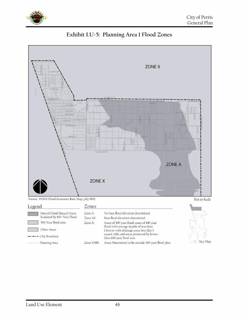
City of Perris General Plan
Land Use Element 46
Exhibit LU-5: Planning Area 1 Flood Zones

City of Perris General Plan
Land Use Element 47
Exhibit LU-6: Planning Area 2 Flood Zones

City of Perris General Plan
Land Use Element 48
Exhibit LU-7: Planning Area 3 Flood Zones

City of Perris General Plan
Land Use Element 49
Exhibit LU-8: Planning Area 4 Flood Zones

City of Perris General Plan
Land Use Element 50
Exhibit LU-9: Planning Area 5 Flood Zones

City of Perris General Plan
Land Use Element 51
Exhibit LU-10: Planning Area 6 Flood Zones

City of Perris General Plan
Land Use Element 52
Exhibit LU-11: Planning Area 7 Flood Zones

City of Perris General Plan
Land Use Element 53
Exhibit LU-12: Planning Area 8 Flood Zones

City of Perris General Plan
Land Use Element 54
Exhibit LU-13: Planning Area 9 Flood Zones
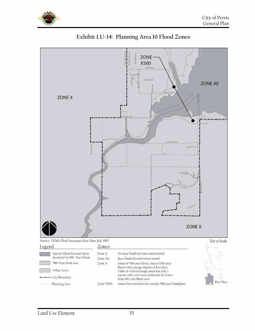
City of Perris General Plan
Land Use Element 55
Exhibit LU-14: Planning Area 10 Flood Zones

City of Perris General Plan
Land Use Element 56
Schools
The City of Perris is served by five (5) school districts: the Val Verde Unified School District (VVUSD), the Perris Union High School District (PUHSD), the Perris Elementary School District (PESD), the Romoland School District (RSD), and the Menifee Union School District (MUSD). Existing schools and future school sites are shown on the map in exhibit LU-15.
Planning Area 2
Future Schools:
Avalon Elementary Northeast corner of Rider Street and Bradley Val Verde Unified School District May Ranch Elementary West/Southwest of May Ranch Val Verde Unified School District
Planning Area 3
Existing School(s):
New Val Verde High School Adjacent to the existing Val Verde School District Offices at 975 W. Morgan Street Val Verde Unified School District
Planning Area 4
Existing School(s):
Val Verde High School, 9-12 Continuation 2935 Indian Avenue, Perris Val Verde Unified School District Current Capacity: 324 Current Enrollment: 481 Val Verde Elementary K-6 2656 Indian Ave., Perris Val Verde Unified School District Current Capacity: 1,024 Current Enrollment: 1,084
Planning Area 5
Existing School(s):
Perris High School 9-12 175 E. Nuevo Road, Perris Perris Union High School District Current Capacity: 2,268 Current Enrollment: 5,163 Palms Elementary School K-5 255 East Jarvis Street, Perris Perris Elementary School District Current Capacity: 878 Current Enrollment: 878
Future School(s):
Southeast corner Mildred and Murrieta 2 sites-Parkwest Specific Plan Perris Elementary School District Elementary School North of Orange between Redlands and Wilson Val Verde Unified School District High School North of Citrus between Dunlap and Evans Val Verde Unified School District

City of Perris General Plan
Land Use Element 57
Planning Area 6
Existing School(s):
Perris Lake High School, 9-12 Continuation 418 W. Ellis Avenue, Perris Perris Union High School District Current Capacity: 252 Current Enrollment: 408
Planning Area 7
Existing School(s):
Pinacate Middle School 7-8 1990 S. A Street, Perris Perris Union High School District Current Capacity: 513 Current Enrollment: 1,405 A Street Elementary K-6 755 North A Street, Perris Perris Elementary School District Current Capacity: 922 Current Enrollment: 922 Enchanted Hills School K-5 1357 Mt. Baldy Street , Perris Perris Elementary School District Current Capacity: 577 Current Enrollment: 577 Nan Sanders Elementary School K-5 1461 North A Street, Perris Perris Elementary School District Current Capacity: 851 Current Enrollment: 851 Park Avenue Elementary School K-5 445 South Park Avenue, Perris Perris Elementary School District Current Capacity: 611 Current Enrollment: 611
Perris Elementary School K-5 5000 South A Street, Perris Perris Elementary School District Current Capacity: 757 Current Enrollment: 757
Future School(s):
Northwest corner Alpine and A Streets Perris Elementary School District
Planning Area 9
Future School(s):
3 sites, Green Valley Specific Plan Romoland School District
Planning Area 10
Future School(s):
1 site, Riverwoods Specific Plan

City of Perris General Plan
Land Use Element 58
Exhibit LU-15: Existing and Future Schools

City of Perris General Plan
Land Use Element 59
Issues, Opportunities, and Constraints
Issues, Opportunities, and Constraints is a synthesis of the input provided by those who live and work in Perris and participated in the General Plan process. It is from this synthesis of perceptions and ideas from the community that the Objectives for the future-oriented Strategy for Action were derived.
Issue #1: Increasing City Revenues through Land Planning
The need to increase municipal revenues is an important issue for the City. Sales tax revenues are a significant part of the City’s budget and can be affected by land use decisions. The City receives a portion of the sales tax on merchandise sold in Perris. For this reason, retail outlets and particularly automobile dealerships, home improvement centers, and major appliance and electronics stores are often preferred over residential uses that generate relatively little revenue to the City. Land use decisions often reflect this fact.
Opportunities
The distribution and location of land use designations may expand the variety of goods and services for residents while expanding sales tax revenue to the City
Property frontages along Interstate 215 and freeway on and off ramps in the City provide visibility for businesses and enable easy access
Constraints
The image of Perris may be a hindrance to new business attraction
Issue #2: Downtown Revitalization
Downtown Perris has historical significance and is an asset to the City. The City has invested in revitalization of the downtown area including preparation of a Specific Plan and infrastructure improvements.
Opportunities
Implementation of the Downtown Specific Plan including related infrastructure improvements will improve the appearance of Downtown
A Metrolink Station is planned for the old Perris Depot area, providing a new spur to Riverside, Los Angeles and Orange Counties, and expanding commuting options for residents of Perris
New development Downtown will increase retail opportunities, and consequently increase sales tax revenues to the City
The Downtown Specific Plan includes a strategy for rehabilitating existing housing
Constraints
Downtown Perris is characterized by deteriorated buildings and empty lots
The City does not have sufficient revenues to complete Downtown revitalization
Perris has an image problem that may make it difficult to attract

City of Perris General Plan
Land Use Element 60
businesses typically associated with upscale, historic downtown areas
Issue #3: Multiple Species Habitat Conservation Plan (MSHCP)
The City of Perris is within the boundaries of the Western Riverside Multiple Species Habitat Conservation Plan (MSHCP). The MSHCP is a criteria-driven, multi-jurisdictional Habitat Conservation Plan intended to create a network of permanent open space to conserve a variety of natural communities and other undeveloped lands that would ensure long-term survival of 146 species of plants and animals. The Plan aims to create a 500,000-acre conservation area from approximately 347,000 acres of existing public/quasi-Public lands and 153,000 acres of existing private land in a 1.26 million-acre MSHCP area. The City of Perris contains 1,300 acres of land within the MSHCP area.
Opportunities
The MSHCP may facilitate regulatory approvals for deepening the Perris Valley Channel and the San Jacinto riverbed to accommodate construction of needed storm drains
Constraints
The MSHCP will reduce the land area available for commercial, retail, or residential development
Construction of proposed on- and off-ramps at I-215 has been delayed because of potential impacts on wildlife habitat areas
Issue #4: Housing
Residential areas in Perris have been characterized as too many homes on small
lots, many of which are in need of repair. An increase in minimum lot size is perceived as a means to promote development of larger, more expensive houses within the City.
Opportunities
Extensive tracts of undeveloped land are available and will accommodate larger minimum lot sizes for more upscale, move-up housing opportunities for current Perris residents
A larger minimum residential lot size may allow expanded outdoor recreation opportunities on residential home sites and eliminate the need for maintenance-intensive “pocket” parks
Constraints
Existing housing in need of rehabilitation may discourage new development on nearby tracts of land.
New affordable housing consistent with the Regional Housing Needs Assessment may conflict with efforts to promote upscale housing
New housing does not generate sufficient revenues to pay for increased demands for municipal services including police and fire protection and maintenance of roads and public facilities
Issue #5: Parks/Bike Trails
The City would like to increase the number and quality of its parks and trails. There are not enough parks to satisfy the demands of user groups and the community at large. A complete trail system throughout the City that connects to other Countywide or regional trail

City of Perris General Plan
Land Use Element 61
systems is desired (please refer to Exhibit CE-14 in the Circulation Element).
Opportunities
A large, centrally-located ballpark would attract regional tournament play and increase revenues to the City
Joint City-school district use of new school facilities can reduce the need for municipally-owned sports playing fields
Participation in public/private partnerships such as the “Field of Dreams” may be a means to providing recreation venues
A larger minimum residential lot size may allow expanded outdoor recreation opportunities and eliminate the need for maintenance-intensive “pocket” parks
Constraints
Existing parks are in need of rehabilitation and upgrading
City impact fees levied on new residential construction do not fully fund acquisition and development of new parks
Extensive “open space” areas indicated for passive recreational uses such as Edison easements, the aqueduct and smaller, one-acre pocket parks do not afford appropriate recreation opportunities for residents
Issue #6: Vacant Land
Significant tracts of land in the City are vacant and/or undeveloped.
Opportunities
The extent of vacant and undeveloped land is an opportunity for the City of Perris to evolve as a balanced community including options for both living and working in the City
Available vacant land accessible to rail, highways, and air transport will allow development of light industry and commerce centers accompanied by new jobs
The March Global Port may create a demand for buildings to accommodate businesses dependent upon air cargo transportation
An expanding labor pool accompanying new residential development may promote new business development and expansion
Constraints
Infrastructure is lacking in the undeveloped areas, and urbanized clusters are dispersed over a wide area
Existing development may not be adequately served by infrastructure characterized by deteriorated roadways, inadequate storm drain capacity, and limited public safety facilities
Issue #7: Infrastructure and Service Delivery
Significant segments of the City’s roadways are in need of substantial repair or reconstruction. Newer developments in outlying areas of the City are not joined with existing urbanized areas by improved roadways. Deteriorated roadways increase timely response by emergency services personnel. Impact fees on new

City of Perris General Plan
Land Use Element 62
development do not fully fund parkland acquisition and development or pay for improving and expanding existing infrastructure. Significant land areas will be needed for detention basins to compensate for lack of adequate regional storm drain capacity and to meet more stringent storm water pollution reduction standards.
Opportunities
The pattern and timing of future development cannot be allowed to outpace construction of infrastructure or the City’s ability to provide essential services
The City may update the existing development impact fee structure to ensure that future development fully funds needed infrastructure
Constraints
New development may be burdened and delayed by increased development impact fees for parks, fire stations, police stations, and storm drain facilities.
Current levels of municipal revenues do not provide for adequate maintenance, repair, and upgrade of existing infrastructure

City of Perris General Plan
Land Use Element 63
Land Use Plan
The Land Use Plan broadly describes the types of land uses and intensity of physical development that will be accommodated in the City of Perris through the year 2030. Land uses are organized and defined in this part of the Land Use Element according to permitted intensity of physical development and types of uses appropriate on a given property. The Land Use Map assigns a land use classification to each property in the City. Together, the Land Use Plan and Land Use Map establish the desired pattern of development for the City of Perris. Decisions about future development reflected in the Land Use Plan and Land Use Map were guided by Objectives formulated for the Policy Document of the Land Use Element. The Objectives reflect input from those who live and work in the City of Perris about the kinds of development that will be accepted as positive change.
Land Use Types
Physical development in the City of Perris is classified according to land use type such as residential, commercial, or industrial. Each land use classification, or designation, is defined below in terms of permissible uses and intensity of physical development. The use and intensity classifications are the basis for permitted uses. Minimum and maximum development standards are described in greater detail and implemented through the Zoning Ordinance. Intensity and density standards are also the basis for minimum lot size and lot street frontage requirements of the Subdivision Ordinance.
“Residential” land use designations include as principal uses all dwelling units equipped for independent living i.e. kitchen, bathroom, and sleeping quarters. The residential land use designations in the General Plan are as follows:
R-20,000 Single-Family Residential, 20,000 sq ft lot is comprised of low-density, single-family dwelling units in a semi-rural or agricultural setting. Other permitted uses include churches and schools. This designation allows for single-family residential dwellings at densities of up to 2 units per acre.
R-10,000 Single-Family Residential, 10,000 sq ft lot is comprised of low-density, single family dwellings at densities of up to 4 dwelling units per acre.
R-8,400 Single-Family Residential, 8,400 sq ft lot allows for low-density, single-family dwellings at densities up to 5 units per acre.
R-7,200 Single-Family Residential, 7,200 sq ft lot allows for low-density, single-family dwellings at densities up to 6 units per acre.
R-6,000 Single-Family Residential, 6,000 sq ft lot allows for low-density, single-family dwellings at densities up to 7 units per acre. Note: Mobilehome subdivisions (zoning classification R5) will also be allowed within this Land Use category. Minimum lot size is consistent with those for SFR 6, which will not increase intensity or density in these areas. By allowing Mobilehome subdivisions within this Land Use category, this City can provide opportunities for affordable housing.

City of Perris General Plan
Land Use Element 64
MFR-14 Multiple-Family Residential is comprised of medium-density, multiple-family residential units. This land use designation allows for a density of up to 14 dwelling units per acre.
MFR-22 Multiple-Family Residential includes high-density, multiple-family dwellings at densities of up to 22 units per acre.
“Commercial” land use categories cover a broad range of non-residential, non-industrial uses. The commercial land use designations in the General Plan are as follows:
Neighborhood Commercial/Urban Residential accommodates mixed-use development. Permitted uses include, but are not limited to, all retail, service and food oriented uses allowed in Neighborhood Commercial category, all professional office oriented uses allowed in Professional Office land use designation, ad all residential uses as described within the MFR-14 land use category. All residential uses are limited to the second floor unless otherwise designated by the Community Development Director.
Neighborhood Commercial accommodates uses including but not limited to business offices, clothing stores, food and drug stores, hardware stores, restaurants and specialty retail stores. This land use designation accommodates retail centers anchored by stores that are less than 50,000 square feet in size and providing goods and services primarily for consumers within two miles of the center.
Community Commercial provides for professional offices, department stores, discount stores, and furniture or appliance outlets. It also allows for home improvement centers, entertainment centers and regional shopping centers. Principal uses in this category typically serve a much broader geographic market than those in the Commercial Neighborhood category.
Professional Office allows administrative and professional offices as principal uses as well as support uses that may include copy centers and food service. Principal uses may also include cultural facilities, financial institutions, and medical facilities.
The “Industrial” category includes small business uses including businesses that require small warehouses or equipment yards (such as General Contractors, carpet and flooring installers, or other construction related trades), light manufacturing uses, materials processing and assembly, distribution centers, and large-scale warehousing. Industrial land use designations in the General Plan are as follows:
Business Park typically includes administrative offices in low-rise buildings often accompanied by accessory inventory storage and distribution, business services including small-scale reprographic and printing uses, warehouse retailers, and automobile dealerships, service commercial.
Light Industrial uses include limited assembly and packaging operations, self-storage warehouses, distribution centers, and business-to-business retail operations.

City of Perris General Plan
Land Use Element 65
General Industrial uses include warehousing facilities, assembly plants, and manufacturing operations that do not involve drop punches or metal casting equipment.
The “Specific Plan” land use designation allows for a variety of uses, densities and building intensities on parcels of seventy-five or more acres subject to a master site plan and comprehensive development standards that provide for flexibility in design, creation of unique neighborhoods, amenities including parks and inclusion of appropriate infrastructure. “Open Space” designates land used for active or passive parkland. In addition, Open Space may apply to undeveloped, natural areas such as the San Jacinto River. Open Space may be either publicly or privately owned, developed or undeveloped, and includes land retained in its undisturbed, natural state or developed areas that include play equipment, ball fields, or other, recreational equipment or facilities. “Public/Semi-Public” land use categories are locations for government facilities, public schools, and public services and utilities such as water and sewer district operations. The “Special Study Area Overlay” designation is juxtaposed on the land use designation of parcels where flexibility in use and development standards may be needed to adapt to infrastructure, including roadways and storm drain facilities.

City of Perris General Plan
Land Use Element 66
Table LU-16: Acreage of Land Use Designations by Planning Area, City of Perris General Plan 2030
2030 General Plan Land Use Designation
PA1 PA2 PA3 PA4 PA5 PA6 PA7 PA8 PA9 PA10 Total % of City
Residential
R-20,000 58 40 0 0 158 21 319 0 0 455 1,051 5.7% R-10,000 0 61 0 0 229 0 727 0 0 279 1,296 7.0% R-8,400 0 0 0 0 26 0 0 0 0 0 26 0.1% R-7,200 0 0 0 0 0 0 0 0 0 0 0 0.0% R-6,000 124 215 0 0 770 146 670 0 246 1,236 3,407 18.5% MFR-14 0 758 22 0 1,099 144 28 0 603 32 2,686 14.6% MFR-22 0 40 0 0 16 0 0 0 49 0 105 0.6%
Commercial
NC/UR 0 0 0 0 0 9 0 0 0 0 9 0.0% NC 0 0 10 0 22 33 6 9 0 0 80 0.4% CC 282 76 207 261 308 53 70 55 287 10 1,609 8.7%
Industrial
BP 261 0 0 280 40 0 0 0 235 0 816 4.4% LI 528 0 1,080 134 0 83 0 587 277 0 2,689 14.6% GI 431 0 0 0 0 0 0 504 0 0 935 5.1%
Office
PO 0 0 0 0 61 14 0 0 0 0 75 0.4%
Other
P 25 2 46 10 289 87 89 160 456 153 1,317 7.2% OS 0 57 55 0 231 17 385 7 72 924 1,748 9.5% SP 465 0 0 113 0 0 0 0 0 0 578 3.2%
Totals 2,174 1,249 1,420 798 3,249 607 2,294 1,322 2,225 3,089 18,427 % of City 11.8% 6.8% 7.7% 4.3% 17.6% 3.3% 12.4% 7.2% 12.1% 16.8% 100%

City of Perris General Plan
Land Use Element 67
Table LU-17: 1991 General Plan and 2030 General Plan
1991 Land Use Designation
1991 Total
2030 Land Use Designation
2030 Total
Change in Acres
Residential
RR/A 1,127 R-20,000 1,051 -76 R4 1,967 R-10,000 1,296 -671 0 R-8,400 26 +26 0 R-7,200 0 0 R7 3,311 R-6,000 3,407 +96 R14 2,587 MFR-14 2,686 +99 R22 105 MFR-22 105 0
Commercial
NC/UR 9 +9 CN 103 NC 80 -23 CC 1,901 CC 1,609 -292
Industrial
BP 619 BP 816 +197 LI 2,429 LI 2,689 +260 GI 935 GI 935 0
Office
PO 97 PO 75 -22
Other
P 1,327 P 1,317 -10 OS 1,919 OS 1,748 -171 0 SP 578 +578
Totals 18,427 18,427
Table LU-18: Population Projections
Year Population
2002 35,848
2030 84,284
Table LU-19: Employment Projections
Year Employment
2002 11,857
2030 23,787

City of Perris General Plan
Land Use Element 68
Land Use Intensity
State law requires that standards for intensity of development be included for each land use category. For residential uses, the maximum permissible number of dwelling units that may be constructed on each acre indicates intensity of development. Population density is estimated by applying data for average number of persons per household to the number of dwellings per acre. Intensity of development in commercial and industrial areas is expressed as Floor Area Ratio (FAR). Floor Area Ratio is the maximum permissible building floor area divided by lot area (FAR = Floor Area of
Building Lot Area). For example, a FAR of “0.5” allows 5,000 square feet of building area on each ten thousand square feet of lot
area (0.5 = 5,000 10,000). FAR allows the building area to be distributed on one, two, or more floors and is not in and of itself a standard for building height. Allowable development intensity for Open Space uses is generally set forth as a function of both maximum lot area coverage and building height. A shower and locker room facility at a swimming pool site, for example, may be limited to ten percent (10%) of lot area and one-story in height as a measurement of maximum permissible density. Appropriate building intensities/ densities for each land use category are established in the General Plan. Table LU-20 shows maximum building density for future development in each of the seven Residential categories of the Land Use Element, expressed as dwelling unit density. Table LU-21 represents maximum building intensity for future development for properties included within Commercial land use categories. Table LU-22
represents maximum building intensity for future development in the industrial land use designations. Table LU-23 shows maximum building intensity for properties designated as Open Space. The maximum building intensities for development in the Public/Semi-Public land use designation are represented in Table LU-24.
Specific Plan
The General Plan land use designation “Specific Plan” promotes flexibility in the arrangement, mix, and intensity of land uses, encourages integration of residential uses with non-residential uses, supports development of amenities including community parks, and intends that building and site design result in attractive neighborhoods consistent with General Plan Goals, Policies, and Implementation Measures. The Specific Plan may to designated properties for development consistent with a master plan development incorporating seventy-five (75) acres or more contiguous acres. A master plan development shall be prepared for each Specific Plan area and will indicate the locations and parcel sizes for each proposed land use. Each proposed land use shall be assigned an appropriate zoning district designation from Title 19, “Zoning”, of the Perris Municipal Code that accommodates the uses and densities or intensities intended for each. The master development plan shall be accompanied by a Specific Plan text that includes proposed design standards, and development criteria if different from those of the applicable zoning district. The Specific Plan text shall include all the information as required by California Government Article 8 “Specific Plans”, Section 65450 et. Seq. The master development plan shall also incorporate the requirements of an “Infrastructure

City of Perris General Plan
Land Use Element 69
Concept Plan” as defined in the Perris General Plan 2030 Land Use Element. Maximum non-residential building area and maximum number of dwelling units permitted within each Specific Plan area shall be determined based on the following:
1) The number of A.M. and P.M. vehicular peak hour trips projected to be generated from within the area subject to the Specific Plan;
2) The number of Average Daily Trips
projected to be generated from within the area subject to the Specific Plan;
3) The assignment and distribution of
projected trips to secondary and arterial roadways providing access to the area subject to the Specific Plan.
Each master development plan shall be accompanied by a traffic study, in a form acceptable to the City Engineer. Permissible intensities and densities of land uses that may be included in the Specific Plan will be determined upon confirmation by traffic study that the total Average Daily Trips projected to be generated from within the area subject to the Specific Plan do not exceed the total Average Daily Trips allocated to that area in the General Plan. The permissible mix and locations of land uses within the area subject to the Specific Plan will be that which minimizes coincident peak hour trips to and from the area subject to the Specific Plan. In no event, however, shall more than seventy-five percent (75%) of the land area included within a Specific Plan, exclusive of right-of-way and parkland, be for residential use.
Special Study Area Overlay
Planning Areas 1, 5, 8, 9, and 10 are comprised of large tracts of vacant land and lack roadway, water, sewer, and storm drain systems. Development of parts of Planning Areas 8, 9 and 10 are dependent upon completion of long-term, large-scale flood control improvements tied to approval of the MSHCP. As a result, these may develop slowly and only as demand for land justifies substantial infrastructure investment. The Special Study Area Overlay recognizes that adjustment of boundaries between adjacent land use designations and changes in types of permitted uses may be needed to accommodate changed, long-term demand.

City of Perris General Plan
Land Use Element 70
Table LU-20: Maximum Permissible Residential Densities*
*Acreage net of dedications and/or easements for streets, rights-of-way, and public facilities.
Table LU-21: Maximum Permissible Commercial Building Intensity**
** FAR = Floor Area Ratio
Single-Family Residential, 20,000 sq ft lots Single-Family Residential, 10,000 sq ft lots Single-Family Residential, 8,400 sq ft lots Single-Family Residential, 7,200 sq ft lots Single-Family Residential, 6,000 sq ft lots Multi-Family Residential, 14.0 units per acre Multi-Family Residential, 22.0 units per acre Neighborhood Commercial/ Urban Residential 14.0 units per acre
0.0-2.0 DU/AC
Up to 4.0 DU/AC
Up to 5.0 DU/AC
Up to 14.0 UN/AC
Commercial Community Neighborhood Commercial Professional Office Neighborhood Commercial/ Urban Residential
0.75:1 FAR
0.50:1 FAR
1.0:1 FAR
Up to 22.0 UN/AC
Up to 6.0 DU/AC
Up to 7.0 DU/AC
Up to 14.0 UN/AC
0.50:1 FAR

City of Perris General Plan
Land Use Element 71
Table LU-22: Maximum Permissible Industrial Building Intensity**
** FAR = Floor Area Ratio
Table LU-23: Maximum Permissible Open Space Building Intensity**
** FAR = Floor Area Ratio
Table LU-24: Maximum Permissible Public Utilities Building Intensity**
** FAR = Floor Area Ratio
Parks/ Recreation/ Open Space:
0.25:1 FAR
Public/ Semi-Public Facilities and Utilities.
0.50:1 FAR
Light Industrial General Industrial Business Park
0.75:1 FAR
0.75:1 FAR
0.75:1 FAR

City of Perris General Plan
Land Use Element 72
Table LU-25: Minimum Lot Sizes
Land Use Category Lot Size
Residential
R-20,000 Single-Family Residential 20,000 square feet R-10,000 Single-Family Residential 10,000 square feet R-8,400 Single-Family Residential 8,400 square feet R-7,200 Single-Family Residential 7,200 square feet R-6,000 Single-Family Residential 6,000 square feet MFR-14 Multi-Family Residential 6,000 square feet MFR-22 Multi-Family Residential 6,000 square feet
Commercial
Neighborhood Commercial/Urban Residential 20,000 square feet Neighborhood Commercial 20,000 square feet Commercial Community 43,560 square feet Professional Office 20,000 square feet
Industrial
Light Industrial 10,000 square feet General Industrial 15,000 square feet Business Park 20,000 square feet
Other
Parks/Recreation/Open Space 5 acres Public/Semi-Public None Specific Plan 75 acres

City of Perris General Plan
Land Use Element 73
Land Use Map
The Land Use Map shows the locations and distribution of land in each of the land use categories identified in the Land Use Plan (Map provided separate from this document).
Development Potential
The planning period for the General Plan is 2030. Rapid growth and consequent changes in the City of Perris will likely require significant update of this General Plan prior to 2030. A planning period through the year 2030 for the General Plan was selected, however, so that future traffic conditions for the City could be projected using the computer traffic model for western Riverside County. This model incorporates development potential and employment projections included in the City of Perris General Plan 2030. The General Plan provides development data for the base year of 2002, for the year 2030, and at full-build-out consistent with the General Plan. Because of the abundance of undeveloped land in the City of Perris in 2003, the General Plan assumes that complete build-out of the City will occur sometime after the year 2030. Implementation of the land use plan including the types of land uses, their distribution, the density and intensity of development, and assumptions about the timeframe within which this development will occur yields the projections about residential and non-residential development in Tables LU-26, LU-27 and LU-28.

City of Perris General Plan
Land Use Element 74
Table LU-26: General Plan Residential 2030
General Plan Residential Land Use Designation
PA1 PA2 PA3 PA4 PA5 PA6 PA7 PA8 PA9 PA10 Total
R-20,000 58 40 0 0 158 21 319 0 0 455 1,051 R-10,000 0 91 0 0 342 0 1,090 0 0 418 1,941 R-8,400 0 0 0 0 65 0 0 0 0 0 65 R-7,200 0 0 0 0 0 0 0 0 0 0 0 R-6,000 1,132 645 0 0 2,311 438 2,010 0 738 3,708 11,182 MFR-14 0 2,656 80 0 3,850 507 101 0 2,113 115 9,422 MFR-22 0 160 0 0 64 0 0 0 196 0 420
Total Units 1,390 3,592 80 0 6,790 966 3,520 0 3,047 4,696 24,081 Population1 4,865 12,572 280 0 23,765 3,381 12,320 0 10,665 16,436 84,284
Table LU-27: General Plan Residential Build-Out
1 Population is derived using an average of 3.5 persons per dwelling unit
General Plan Residential Land Use Designation
PA1 PA2 PA3 PA4 PA5 PA6 PA7 PA8 PA9 PA10 Total
R-20,000 58 60 0 0 158 21 319 0 0 465 1,081 R-10,000 0 91 0 0 622 0 3,692 0 0 697 5,102 R-8,400 0 0 0 0 0 0 0 0 0 0 65 R-7,200 0 0 0 0 0 0 0 0 0 0 0 R-6,000 1,611 1,2,90 0 85 5,606 901 2,412 0 1,207 5,044 18,156 MFR- 14 325 5,976 200 99 7,864 756 201 0 3,599 202 19,222 MFR-22 0 320 0 0 348 0 0 0 392 0 1,060
Total Units 1,994 7,737 200 184 14,663 1,678 6,624 0 5,198 6,408 44,686 Population1 6,979 27,080 700 644 51,320 5,873 23,184 0 18.193 22,428 156,401

City of Perris General Plan
Land Use Element 75
Table LU-28: Building Area by Land Use Designation
Building Area by Land Use Designations Planning Area 1 Year 2002 Year 2030 Build-Out
General Industrial 280,6943 479,000 4,504,750 Light Industrial See Footnote 3 711,847 6,658,097 Business Park -0- 294,465 3,627,465 Professional Office -0- -0- -0- Community Commercial 19,340 300,000 744,000 Neighborhood Commercial -0- -0- -0- Public Facilities -0- -0- -0-
Total Building Area 300,034 1,785,312 15,534,312
3 Data includes “General Industrial” and “Light Industrial” classifications.
Planning Area 2 Year 2002 Year 2030 Build-Out
General Industrial -0- -0- -0- Light Industrial -0- -0- -0- Business Park -0- -0- -0- Professional Office -0- -0- -0- Community Commercial -0- 35,000 206,038 Neighborhood Commercial -0- -0- -0- Public Facilities -0- -0- -0-
Total Building Area -0- 35,000 206,038
Planning Area 3 Year 2002 Year 2030 Build-Out
General Industrial -0- -0- -0- Light Industrial 917,681 3,613,974 10,891,380 Business Park -0- -0- -0- Professional Office -0- -0- -0- Community Commercial 102,962 333,500 1,521,000 Neighborhood Commercial -0- 90,000 90,000 Public Facilities 58,000 267,000 267,000
Total Building Area 1,88,643 4,304,474 12,769,380
Planning Area 4 Year 2002 Year 2030 Build-Out
General Industrial -0- -0- -0- Light Industrial 349,678 478,514 648,514 Business Park -0- 706,679 1,268,302 Professional Office -0- -0- -0- Community Commercial 239,503 400,342 2,200,684 Neighborhood Commercial -0- -0- -0- Public Facilities 88,000 138,000 138,000
Total Building Area 647,181 1,723,535 4,255,500

City of Perris General Plan
Land Use Element 76
Building Area by Land Use Designations Planning Area 5 Year 2002 Year 2030 Build-Out
General Industrial -0- -0- -0- Light Industrial -0- -0- -0- Business Park -0- 90,000 90,000 Professional Office -0- 72,000 163,466 Community Commercial 288,798 341,006 673,006 Neighborhood Commercial -0- 10,000 21,000 Public Facilities 265,000 298,220 298,220
Total Building Area 553,798 811,226 1,245,692
Planning Area 6 Year 2002 Year 2030 Build-Out
General Industrial -0- -0- -0- Light Industrial 176,000 250,545 421,545 Business Park -0- -0- -0- Professional Office 74,000 114,500 131,000 Community Commercial 185,000 371,000 525,000 Neighborhood Commercial 124,000 165,000 226,000 Neighborhood Commercial/ Urban Residential
45,000 45,000
Public Facilities 452,000 550,010 550,010
Total Building Area 1,011,000 1,399,500 1,807,000
Planning Area 7 Year 2002 Year 2030 Build-Out
General Industrial -0- -0- -0- Light Industrial -0- -0- -0- Business Park -0- -0- -0- Professional Office -0- -0- -0- Community Commercial 45,000 67,000 87,902 Neighborhood Commercial -0- 30,000 30,000 Public Facilities 408,000 557,000 557,000
Total Building Area 453,000 654,000 674,902
Planning Area 8 Year 2002 Year 2030 Build-Out
General Industrial 383,000 667,000 1,139,848 Light Industrial 115,000 863,000 4,647,098 Business Park -0- -0- -0- Professional Office -0- -0- 377,000 Community Commercial 79,600 158,000 184,000 Neighborhood Commercial -0- 40,000 60,000 Public Facilities -0- -0- -0-
Total Building Area 577,600 1,728,000 6,407,946

City of Perris General Plan
Land Use Element 77
Building Area by Land Use Designations Planning Area 9 Year 2002 Year 2030 Build-Out
General Industrial -0- -0- -0- Light Industrial 35,000 285,000 400,000 Business Park -0- 211,000 656,000 Professional Office -0- -0- -0- Community Commercial 7,000 364,000 2,810,000 Neighborhood Commercial -0- -0- 185,000 Public Facilities 50,000 95,000 95,000
Total Building Area 92,000 955,000 4,146,000
Planning Area 10 Year 2002 Year 2030 Build-Out
General Industrial -0- -0- -0- Light Industrial -0- -0- -0- Business Park -0- -0- -0- Professional Office -0- -0- -0- Community Commercial -0- -0- 82,000 Neighborhood Commercial -0- -0- -0- Public Facilities -0- 80,000 200,000
Total Building Area -0- 80,000 282,000
All Planning Areas Year 2002 Year 2030 Build-Out
General Industrial 663,694 1,146,000 5,644,598 Light Industrial 1,593,359 6,202,880 23,666,634 Business Park -0- 1,302,144 5,641,767 Professional Office 74,000 186,500 759,368 Community Commercial 967,203 2,369,848 8,956,630 Neighborhood Commercial 124,000 335,000 612,000 Neighborhood Commercial/ Urban Residential
45,000 45,000
Public Facilities 1,321,000 1,985,230 2,105,230
Total Building Area 4,743,256 13,575,602 47,434,227

City of Perris General Plan
Land Use Element 78
Population Projections
Implementation of the land use plan including the types of land uses, their distribution, the density and intensity of
development, and assumptions about the timeframe within which this development will occur yields the population projections in Table LU-29.
Table LU-29: General Plan Population Projections
Employment Projections
Implementation of the land use plan including the types of land uses, their distribution, the density and intensity of
development, and assumptions about the timeframe within which this development will occur yields the employment projections in Table LU-30.
Table LU-30: General Plan Employment Projections
General Plan Employment Projections Planning Area Year 2002 Year 2030 Build-Out
Planning Area 1 923 2,312 20,307 Planning Area 2 -0- 70 412 Planning Area 3 4,271 5,737 14,986 Planning Area 4 1,979 3,580 8,411 Planning Area 5 839 2,278 3,196 Planning Area 6 2,046 3,657 4,377 Planning Area 7 130 2,051 2,093 Planning Area 8 1,570 2,115 7,750 Planning Area 9 99 1,720 7,801 Planning Area 10 -0- 267 831
Total 11,857 23,787 70,164
General Plan Population Projections Planning Area Year 2002 Year 2030 Build-Out
Planning Area 1 552 4,865 6,978 Planning Area 2 2,230 12,572 27,080 Planning Area 3 625 280 700 Planning Area 4 -0- -0- 644 Planning Area 5 21,903 23,765 51,320 Planning Area 6 4,387 3,380 5,871 Planning Area 7 6,033 12,320 23,184 Planning Area 8 32 -0- -0- Planning Area 9 7 10,664 18,193 Planning Area 10 79 16,436 22,428
Totals 35,848 84,284 156,398
City of Perris General Plan
Land Use Element 79
Special Study Area Overlay
Properties within the Special Study Area Overlay are allowed flexibility in their designated land use in order to reflect the location of regional roadway improvements and the changing development demands and patterns of the City. There are three areas where the Special Study Area Overlay may be applied: the Oleander Road corridor, the Ethanac Road corridor and the Ramona Expressway corridor. In Planning Area 1, the land use demand for the area along the Ramona Expressway is dependent on the future alignment and expansion of the roadway. By applying the Special Study Area Overlay to properties along the corridor, the City and property owners are given the latitude to adapt to changing market demand. For example, growth may result in a long-term increase in the amount of land designated for Light Industrial and Business Park, and a simultaneous reduction in the amount of land designated as Community Commercial, or may result in a need for more Community Commercial land and a reduction in Business Park/Industrial land. The same concept can be applied to the Oleander Road corridor given that it is also dependent on the future alignment of the roadway. Oleander Road will be located to the south of its originally projected alignment, impacting existing parcels in its path. New right-of-way dedications will be required for the realignment. In Planning Areas 9 and 10, additional appropriately located land designated for Community Commercial will be required over the long term, accompanying extensive residential development. Appropriate locations for Community Commercial will be identified when design details and access restrictions for the
Ramona Expressway and in the Ethanac Road corridor become known. Early identification in the development review process of opportunities and obstacles to integration require that entitlement applications for properties in the Special Study Area Overlay include an Infrastructure Concept Plan (see following section).
Infrastructure Concept Plan
The City of Perris is characterized by several physical attributes which warrant improvement through the Year 2030. These include:
Unimproved or badly deteriorated roadways and roadways without sufficient capacity for anticipated new development;
Inadequate storm drain infrastructure;
Insufficient parkland and recreation facilities;
Inadequate public safety facilities.
In the extreme, inadequate roadway infrastructure and lack of public safety facilities are an impediment to rapid response by emergency services. Flooding of streets and private properties because of lack of adequate storm drain capacity is a risk to public safety. The community’s youth are at a disadvantage for lack of recreation options. In all instances, inadequate infrastructure is a detriment to the quality of life of those living and working in Perris and the overall image of the City. A comprehensive approach to meeting these infrastructure needs will ensure that:
Development does not precede construction of appropriate infrastructure;

City of Perris General Plan
Land Use Element 80
Opportunities for cost sharing of improvements among property owners are identified;
Joint-use and dual use facilities are developed wherever feasible; and
Proposed development is consistent with the community’s vision for Perris.
A comprehensive approach to meeting infrastructure needs in Perris will include preparation of an Infrastructure Concept Plan to accompany each application for discretionary approval for any of the following:
General Plan Amendment;
Tentative Parcel or Tentative Tract Map;
Development proposal that includes extension of an existing street or construction of a new street;
Each Infrastructure Concept Plan shall include at a minimum the following:
Indication of existing development on adjoining properties;
Arrangement of proposed uses on site;
Existing and proposed rights-of-way for vehicular access to the property;
Locations of vehicular access to the site;
Location of community park to be funded and/or dedicated if development is residential;
Location and size of shared regional interim storm water and water quality detention facilities;
Infrastructure Concept Plans will identify precise locations, land requirements, and timing of required infrastructure development. Each Infrastructure Concept Plan will be the basis for conditions of project approval requiring that infrastructure will be developed in a timely
manner and that the costs for same are allocated proportionate to benefit received. Additional information may be required for an Infrastructure Concept Plan as needed to support development project approval findings as follows:
Improvements on private property will not conflict with potential right-of-way land acquisitions and the placement of future roadway improvements;
Vehicular access to properties will not interfere with attainment of project objectives for planned roadway improvements or conflict with the configuration of future roadway improvements;
Configuration of both on-site and off-site improvements will not be an impediment to future extension or construction of new public roadways providing access to other properties in the area;
Land of appropriate size and location will be reserved and acquired for infrastructure and municipal facilities consistent with those set forth in the Land Use Plan and in the Open Space Element;
Necessary funding of land acquisition and/or improvements for identified infrastructure and municipal facilities will be available consistent with the need for such improvements.
Residential Site Design
Quality housing in attractive neighborhoods is a stated goal of the General Plan. Standards for building design and development should reflect the community’s perception of the ideal neighborhood.
City of Perris General Plan
Land Use Element 81
Positive design changes for new neighborhoods may be accomplished by revising residential development standards addressing the following:
Crowded appearance among dwellings on lots with frontages of less than 40 feet;
Dominance of streetscapes by garages and driveways;
Dwelling entries far removed from street frontages;
Narrow and deep front yards in shadow of and dominated by adjacent attached garage.
The Zoning Ordinance may be amended to promote attractive streetscapes. This is important to the goal of accommodating a range of lot sizes and housing types consistent with changing market demands. The following may be incorporated into design guidelines requiring affirmative findings of consistency as a condition of site plan approval:
The placement of dwellings throughout the tract provides sufficient variety so as not to present a visually monotonous streetscape
Exterior walls of living areas including pedestrian entry doors, rather than garages, are visually prominent along the streetscape;
Floor plans and site orientation of adjacent dwellings afford privacy in both outdoor and indoor living areas
Attention also needs to be paid to street-side perimeters on the exteriors of subdivisions. Visual dominance of this streetscape by unbroken expanses of pavement and sidewalks and deteriorated wooden fencing is a detriment to both the City’s image and property values. Street-side perimeters of new subdivisions may be enhanced through inclusion of perimeter
landscaping and well-defined subdivision entry points. This minimum requirement for new residential developments would be accomplished by incorporating the following requirements into the Subdivision Ordinance:
Each tentative tract map shall include common area lot(s) for perimeter landscaping and entryway monumentation;
Each tentative tract map shall be accompanied by Conditions, Covenants, and Restrictions defining the organizational structure, rules for governance, and method of funding maintenance of common area amenities including perimeter walls, fences, and landscaping.
Multiple Species Habitat Conservation Plan
An individual property could be affected by the MSHCP in one of two ways: the property can lie within the MSHCP Reserve area; or it may lie in the Criteria Area (Exhibit LU-16). It is expected that property within the Reserve Area will be acquired to ensure conservation of the species (animal and plant) specified within the Plan. Owners of property in the MSHCP Reserve area may be eligible for various incentives in lieu of or in addition to monetary compensation in exchange for the conveyance of a property interest. These incentives may include but are not limited to:
Waiver and/or reduction of certain development fees
Monetary compensation for entering into an option agreement
Fast track processing
Density bonuses

City of Perris General Plan
Land Use Element 82
Dwelling Unit Clustering
Density transfers (and property reassessment and tax credits if determined to be feasible)
The incentives are intended to provide a form of compensation to property owners who convey their property. As properties are acquired they will become part of the MSHCP Reserve. Any development proposals involving property within the Reserve area boundaries will be subject to specialized review procedures. Exhibit LU-16 depicts the Criteria Area as a series of numbered “cells”. The Reserve area is also depicted on Exhibit LU-16.
Hazards as Constraints to Development
Various areas of the City are at risk of damage due to disasters such as floods, wildfires, or seismic events. Development within these areas is subject to development restrictions to protect both people and property from those hazards. As a result, the following hazards maps (located in the Safety Element) will be consulted by planning staff as part of the review process for all development applications:
Wildfire Constraint Areas
Flood Zones
Dam Inundation Areas
Earthquake Fault Zones
Liquefaction Hazards
Slope Instability
March ARB Influence Areas
Perris Valley Airport Influence Area
Changes in Land Use Map
Table LU-31 on the following page and Exhibits LU-17 through LU-27, provided under separate cover, indicate the land use changes effected by adoption of the Perris General Plan 2030.

City of Perris General Plan
Land Use Element 83
Exhibit LU-16: MSHCP Reserve and Criteria Areas

City of Perris General Plan
Land Use Element 84
Exhibit LU-17: Land Use Designation Changes
(Provided under separate cover)

City of Perris General Plan
Land Use Element 85
Table LU-31: Land Use Designation Changes
Site Number
Location/Description Acres 1991 GP Land Use
Designation
New Land Use
Designation
Planning Area 1
PA 1-1
Webster to the west, Ramona to the south, Brennan to the east
6 RR/A NC
PA 1-2
Oleander to the north, Perris Blvd. to the west, Jason to the south, Johnson to the east
17 R7 BP
PA 1-3
Oleander to the north, Redlands to the west, Perry to the south, Perris Valley Storm Drain to the east
85 R7 SP
PA 1-4
Oleander to the north, Perris Valley Storm Drain to the west, Ramona Expressway to the south, and the City limits to the east
244 R4 SP
PA 1-5
Oleander to the north, Murrieta to the west, and the City limits to the east
137 R4 R-6,000
PA 1-6
Perry to the north, Redlands to the west, Ramona Expressway to the south, Perris Valley Storm Drain to the east
25 CC SP
PA 1-7
Northwest corner of Murrieta and Ramona Expressway
5 CN SP
150’ north and south of the centerline on Ramona Expressway, with extended widths at Perris Blvd.
Ramona Expressway
Overlay
150’ north and south of centerline on Oleander Ave.
Oleander Road
Overlay

City of Perris General Plan
Land Use Element 86
Site Number
Location/Description Acres 1991 GP Land Use
Designation
New Land Use
Designation
Planning Area 2
PA 2-1
MWD Aqueduct to the north, Wilma to the east (Including all of the MWD Aqueduct)
OS P
PA 2-2
Bradley to the west, Rider to the south, Main to the east
17 RR/A MFR-14
PA 2-3
Rider to the north, Bradley to the west, Main to the east
14 RR/A R-10,000
150’ north and south of the centerline on Ramona Expressway, with extended widths at Perris Blvd.
Ramona
Expressway Overlay
Planning Area 3
PA 3-1 MWD Aqueduct
OS P
PA 3-2 Rider to the north, Wilson to the east
11 CN LI
150’ north and south of the centerline on Ramona Expressway, with extended widths at Perris Blvd.
Ramona
Expressway Overlay
Planning Area 4
PA 4-1
Placentia to the north, Frontage to the west, Orange to the south, Barrett to the east
113 BP SP
Planning Area 5
PA 5-1
Rider to the north, Perris to the west, Lakeview to the east
35 R4 R-6,000
PA 5-2
North of Avocado between Perris and Medical Center
9 CC MFR-14
PA 5-3 Southeast corner of Nuevo & Wilson
2 PO R-6,000

City of Perris General Plan
Land Use Element 87
Site Number
Location/Description Acres 1991 GP Land Use
Designation
New Land Use
Designation
Planning Area 5 (Continued)
PA 5-4
Bowen to the north, Metz to the south, Richards to the east
4 R14 R-6,000
PA 5-5
Bowen to the north, Jarvis to the south, Perris Blvd. to the east
26 R14 R-8,400
PA 5-6
Jarvis to the north, I-215 to the southeast, Perris Blvd. to the east
3 PO MFR14
PA 5-7
North of Orange between Redlands and Wilson
10 R4 P
PA 5-8
Nuevo to the south, Citrus to the north, Redlands to the west
47 R4 MFR-14
PA 5-9 Northeast corner of Citrus & Evans
4 R4 R-6,000
PA 5-10 Southeast corner of Sunset &Nuevo
12 R4 R-6,000
PA 5-11
South of Sunset, approx. 200’ north of Nuevo, Evans to the west, El Nido to the east
13 CC R-6,000
PA 5-12
Sunset to the north, Approx. 200’ north of Nuevo, Perris Valley Storm Drain to the east
15 PO R-10,000
PA 5-13 Northeast corner of El Nido & 7th Street
5 P MFR-14
PA 5-14 Northwest corner of San Jacinto & Murrieta
10 CC R-6,000
From eastern City Limit to the west along the San Jacinto River
MSHCP Overlay
Planning Area 6
PA 6-1 South of 7th between Perris and “G” Street
17 R7,LI MFR-14
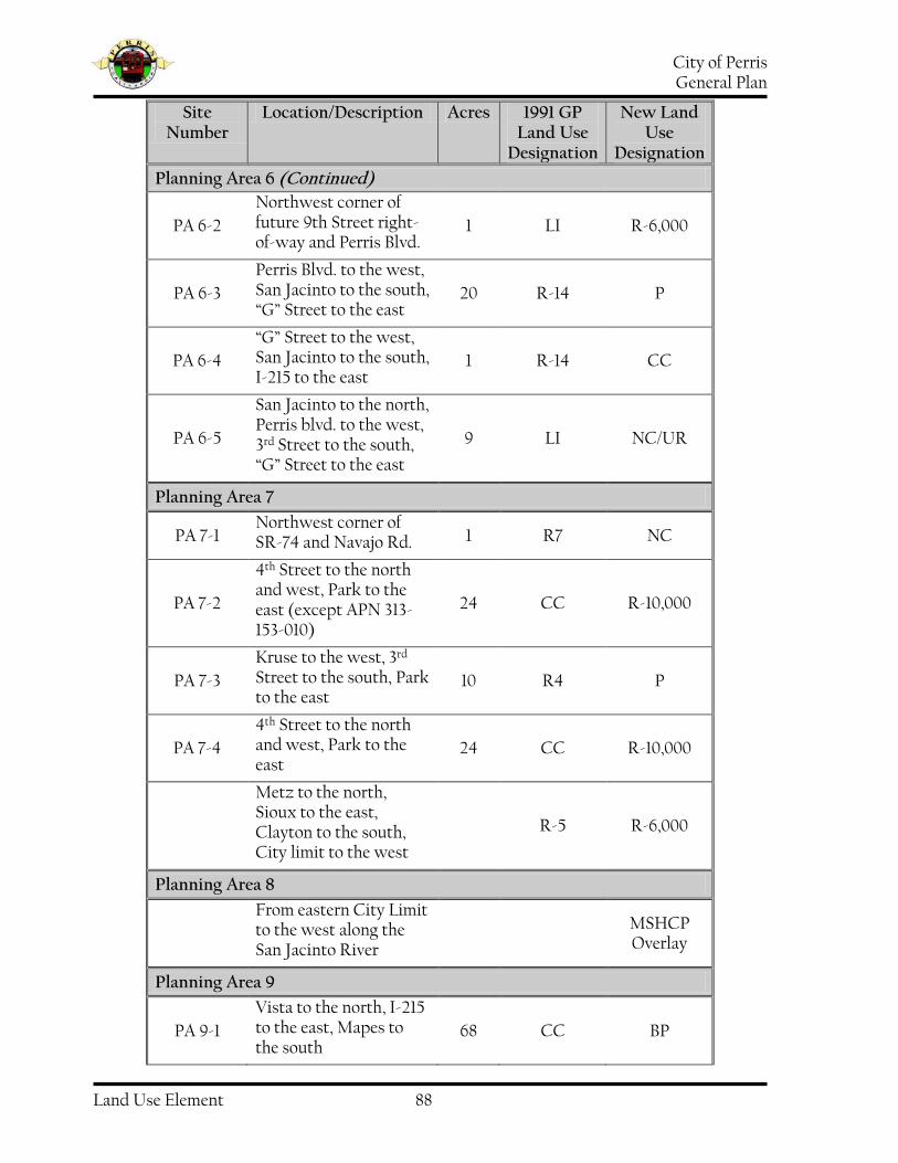
City of Perris General Plan
Land Use Element 88
Site Number
Location/Description Acres 1991 GP Land Use
Designation
New Land Use
Designation
Planning Area 6 (Continued)
PA 6-2
Northwest corner of future 9th Street right-of-way and Perris Blvd.
1 LI R-6,000
PA 6-3
Perris Blvd. to the west, San Jacinto to the south, “G” Street to the east
20 R-14 P
PA 6-4
“G” Street to the west, San Jacinto to the south, I-215 to the east
1 R-14 CC
PA 6-5
San Jacinto to the north, Perris blvd. to the west, 3rd Street to the south, “G” Street to the east
9 LI NC/UR
Planning Area 7
PA 7-1 Northwest corner of SR-74 and Navajo Rd.
1 R7 NC
PA 7-2
4th Street to the north and west, Park to the east (except APN 313-153-010)
24 CC R-10,000
PA 7-3
Kruse to the west, 3rd Street to the south, Park to the east
10 R4 P
PA 7-4
4th Street to the north and west, Park to the east
24 CC R-10,000
Metz to the north, Sioux to the east, Clayton to the south, City limit to the west
R-5 R-6,000
Planning Area 8
From eastern City Limit to the west along the San Jacinto River
MSHCP Overlay
Planning Area 9
PA 9-1
Vista to the north, I-215 to the east, Mapes to the south
68 CC BP

City of Perris General Plan
Land Use Element 89
Site Number
Location/Description Acres 1991 GP Land Use
Designation
New Land Use
Designation
Planning Area 9 (Continued)
PA 9-2
Vista to the north, San Jacinto River to the west, Mapes to the south, Sherman to the east
40 P BP
150’ north and south of the centerline, with an extended northern width to Watson from I-215 to the east and River to the west
Ethanac Road
Overlay
From eastern City Limit to the west along the San Jacinto River
MSHCP Overlay
Planning Area 10
150’ north and south of the centerline, with an extended northern width to Watson from I-215 to the east and River to the west
Ethanac Road
Overlay
From eastern City Limit to the west along the San Jacinto River
MSHCP Overlay

City of Perris General Plan
Land Use Element 90
Strategy for Action
The Land Use Element Strategy for Action reflects the community’s expectations and ambitions for positive changes in the physical environment of the City and how these are to be achieved. Strategy for Action “Goals” represents a synthesis of input from those who live and work in the City of Perris and define desired General Plan outcomes. Outcomes consistent with these Objectives will coalesce into an environment of the highest quality and livability possible for the City of Perris in the year 2030. “Policies” included in the Strategy for Action provide the overall direction for choosing among alternative courses of action necessary to achieve the Objectives set forth in the Strategy for Action. Policies provide a measure of flexibility needed to adapt the course of action to changes in the circumstances occurring during the estimated thirty-year time span of the General Plan. “Implementation Measures” are specific, discreet actions the City may take to make the Land Use Plan a reality. Implementation Measures define the municipal work program for building the future physical environment envisioned in Objectives, depicted in the Land Use Plan, and consistent with Land Use Element Policies.
Goals, Policies, and Implementation Measures
Goal I Quality housing in attractive neighborhoods for households at all income levels and stages of life
Policy I.A Promote variety in dwelling types, densities, and locations to satisfy changing demands as the community evolves and matures Implementation Measures I.A.1 Revise the Zoning Ordinance to
include performance-based standards for site plan and unit design for residential subdivisions substantially consistent with “Residential Site Design” in the Land Use Plan
I.A.2 Revise the Subdivision and Zoning
Ordinances to require common area lot(s) for perimeter landscaping and entryway monumentation
I.A.3 Require inclusion of new
residential development within a Landscape and Lighting District or comparable organization as a condition of tentative tract map approval for the purpose of funding maintenance of common area improvements
I.A.4 Revise the Zoning Ordinance to
increase the minimum lot size and include maximum permissible densities as follow:
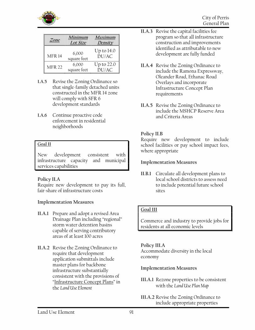
City of Perris General Plan
Land Use Element 91
Zone Minimum Lot Size
Maximum Density
MFR 14 6,000
square feet
Up to 14.0 DU/AC
MFR 22 6,000
square feet Up to 22.0
DU/AC I.A.5 Revise the Zoning Ordinance so
that single-family detached units constructed in the MFR 14 zone will comply with SFR 6 development standards
I.A.6 Continue proactive code
enforcement in residential neighborhoods
Goal II New development consistent with infrastructure capacity and municipal services capabilities
Policy II.A Require new development to pay its full, fair-share of infrastructure costs Implementation Measures II.A.1 Prepare and adopt a revised Area
Drainage Plan including “regional” storm water detention basins capable of serving contributory areas of at least 100 acres
II.A.2 Revise the Zoning Ordinance to
require that development application submittals include master plans for backbone infrastructure substantially consistent with the provisions of “Infrastructure Concept Plans” in the Land Use Element
II.A.3 Revise the capital facilities fee program so that all infrastructure construction and improvements identified as attributable to new development are fully funded
II.A.4 Revise the Zoning Ordinance to
include the Ramona Expressway, Oleander Road, Ethanac Road Overlays and incorporate Infrastructure Concept Plan requirements
II.A.5 Revise the Zoning Ordinance to
include the MSHCP Reserve Area and Criteria Areas
Policy II.B Require new development to include school facilities or pay school impact fees, where appropriate Implementation Measures II.B.1 Circulate all development plans to
local school districts to assess need to include potential future school sites
Goal III Commerce and industry to provide jobs for residents at all economic levels
Policy III.A Accommodate diversity in the local economy Implementation Measures III.A.1 Rezone properties to be consistent
with the Land Use Plan Map III.A.2 Revise the Zoning Ordinance to
include appropriate properties

City of Perris General Plan
Land Use Element 92
within Special Study Areas and identify milestones for changing their land use designations to provide a balance among Community Commercial, Business Park, and Light Industrial properties
III.A.3 Include funding in municipal
budgets necessary to implement sustained, methodical code enforcement in “Planning Area 1: North Commercial/Industrial” as a means to promoting private investment
III.A.4 Prepare a City marketing brochure
to supplement broker and property owner offerings to businesses considering locating in Perris
III.A.5 Conduct a Comprehensive Fiscal
Analysis for possible annexation of Sphere of Influence properties on the westerly edge of Interstate 215 as a means to effect property upgrades in the area
Goal IV Consistency among all planning documents
Policy IV.A The General Plan and the Zoning Code shall be revised and updated to maintain consistency with each other, and with regional plans Implementation Measures IV.A.1 Change the Zoning Code and
Zoning Map to ensure consistency with the Land Use Plan.
Goal V Protection from natural or man-made disasters
Policy V.A Restrict development in areas at risk of damage due to disasters Implementation Measures V.A.1 Consult hazards maps as part of the
review process for all development application
Policy V.B. Ensure land use compatibility near March Air Reserve Base/Inland Port (ARB/IP) by implementing the policies of the 2014 March ARB/IP Airport Land use Compatibility Plan (ALUCP). Implementation Measures V.B.1. Create and prepare an Airport
Overlay Zone (AOZ) to reflect the boundaries and policies of the 2014 March ARB/IP ALUCP.
Policy V.C Ensure land use compatibility within current Air Force Guidance found in the most recent Air Force Instruction (AFI) 32-7063 which addresses Air Force policies on Land use Compatibility IAW DoDI 4165.57 Implementation Measures V.C.I. Circulate all development plans within the Clear Zone and Accident Potential Zones of the March Air Reserve Base/Inland Port Plan to Department of the Air Force, MARCH Air Reserve Base to provide recommendations and guidance on land use compatibility in accordance with the policies of the most recent Air Force Instruction (AFI) 32-7063.
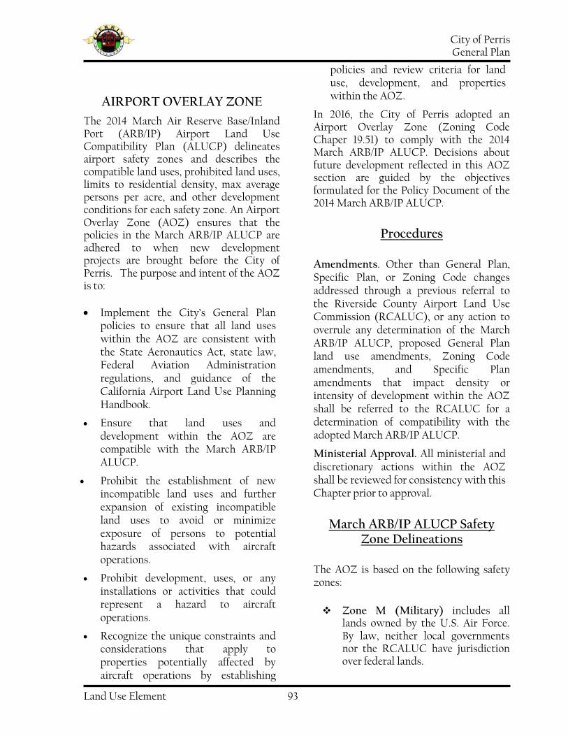
City of Perris General Plan
Land Use Element 93
AIRPORT OVERLAY ZONE
The 2014 March Air Reserve Base/Inland Port (ARB/IP) Airport Land Use Compatibility Plan (ALUCP) delineates airport safety zones and describes the compatible land uses, prohibited land uses, limits to residential density, max average persons per acre, and other development conditions for each safety zone. An Airport Overlay Zone (AOZ) ensures that the policies in the March ARB/IP ALUCP are adhered to when new development projects are brought before the City of Perris. The purpose and intent of the AOZ is to:
Implement the City’s General Plan policies to ensure that all land uses within the AOZ are consistent with the State Aeronautics Act, state law, Federal Aviation Administration regulations, and guidance of the California Airport Land Use Planning Handbook.
Ensure that land uses and development within the AOZ are compatible with the March ARB/IP ALUCP.
Prohibit the establishment of new incompatible land uses and further expansion of existing incompatible land uses to avoid or minimize exposure of persons to potential hazards associated with aircraft operations.
Prohibit development, uses, or any installations or activities that could represent a hazard to aircraft operations.
Recognize the unique constraints and considerations that apply to properties potentially affected by aircraft operations by establishing
policies and review criteria for land use, development, and properties within the AOZ.
In 2016, the City of Perris adopted an Airport Overlay Zone (Zoning Code Chaper 19.51) to comply with the 2014 March ARB/IP ALUCP. Decisions about future development reflected in this AOZ section are guided by the objectives formulated for the Policy Document of the 2014 March ARB/IP ALUCP.
Procedures
Amendments. Other than General Plan, Specific Plan, or Zoning Code changes addressed through a previous referral to the Riverside County Airport Land Use Commission (RCALUC), or any action to overrule any determination of the March ARB/IP ALUCP, proposed General Plan land use amendments, Zoning Code amendments, and Specific Plan amendments that impact density or intensity of development within the AOZ shall be referred to the RCALUC for a determination of compatibility with the adopted March ARB/IP ALUCP.
Ministerial Approval. All ministerial and discretionary actions within the AOZ shall be reviewed for consistency with this Chapter prior to approval.
March ARB/IP ALUCP Safety Zone Delineations
The AOZ is based on the following safety zones:
Zone M (Military) includes all lands owned by the U.S. Air Force. By law, neither local governments nor the RCALUC have jurisdiction over federal lands.
City of Perris General Plan
Land Use Element 94
Zone A (Clear Zone) contains lands within the Clear Zone (CZ) at each end of the runway, but not on the base property. As defined by the 2005 Air Installation Compatible Use Zone (AICUZ), the clear zones are 3,000 feet wide and 3,000 feet long beginning at the runway ends. Zone A at the south end of the runway includes privately owned land. The U.S. Air Force has acquired restrictive use easements preventing the development of this property.
Zone B1 (Inner Approach/Departure Zone) - encompasses areas of high noise and high accident potential risk within the inner portion of the runway approach and departure corridors. The zone is defined by the boundaries of Accident Potential Zones (APZs) I and II, adjusted on the north to take into account the turning departure flight tracks. The majority of the zone is exposed to projected noise levels in excess of 65 dB CNEL.
Zone B2 (High Noise Zone) - is similar to Zone B1 in terms of noise impact, but is subject to less accident potential risk. The projected 65 dB CNEL contour forms the basis for the zone boundary. The actual boundary follows roads, parcel lines or other geographic features that lie generally just beyond the contour line. Lands within the APZs are excluded from Zone B2. Most of the zone lies adjacent to the runway. To the north, portions extend along the sides of Zone B1. To the south, a small area borders the sides of Zones A and B1 and a larger area extends two (2) miles beyond the south end of Zone B1.
Zone C1 (Primary Approach/Departure Zone) -
encompasses most of the projected 60 dB CNEL contour plus immediately adjoining areas. The zone boundary follows geographic features. Accident potential risks are moderate in that aircraft fly at low altitudes over or near the zone. To the south, an area beginning just beyond Nuevo Road—approximately five (5) miles from the runway end—is excluded from the zone. Exposure to noise in this area is greater (above 60 dB CNEL), however, the accident potential risks at this distance from the runway are reduced by the altitude at which aircraft typically fly over the area. Single-event noise levels are potentially disruptive in this zone.
Zone C2 (Flight Corridor Zone) contains the remainder of the lands within the 60 dB CNEL contour to the south. Although aircraft overflying this area are at 2,000 feet or more above the runway on descent and generally 3,000 feet or more on takeoff, single-event noise levels combined with the frequency of overflights, including at night, make noise a moderate compatibility concern. A larger portion of Zone C2 is situated to the west of the airport and includes locations above which most of the military closed-circuit flight training aircraft activity takes place. Aircraft overfly this area at circuit altitude (3,000 feet) or higher (similar to the south portion of Zone C2), but high terrain in some locations makes the flight altitude above ground level comparatively lower. Single-event noise levels in this area can be intrusive. However, at present, nearly all of the flight training activity takes place on weekdays during daylight hours, thus reducing the significance of

City of Perris General Plan
Land Use Element 95
the noise impact on residential land uses. Accident potential risk levels in both portions of Zone C2 are judged to be moderate to low with flight training aircraft activity being the primary concerns
Zone D (Flight Corridor Buffer) - is intended to encompass other places where aircraft may fly at or below 3,000 feet above the airport elevation either on arrival or departure. Additionally, it includes locations near the primary flight paths where aircraft noise may be loud enough to be disruptive. Direct overflights of these areas may occur occasionally. Accident potential risk levels in this zone are low.
Zone E (Other Airport Environs) - contains the remainder of the Airport Influence Area (AIA). Noise impacts are low (this area is beyond the 55-CNEL noise contour), and risk of accidents is low. Airspace protection is the major concern in that aircraft pass over these areas while flying to, from, or around March ARB/IPA.
The High Terrain Zone - serves a more focused purpose than the preceding eight zones. It is intended to identify locations where objects may be hazards to the aircraft operating in the airport’s airspace and require careful review. This zone is within the FAR Part 77 surfaces for March ARB/IP.

City of Perris General Plan
Land Use Element 96
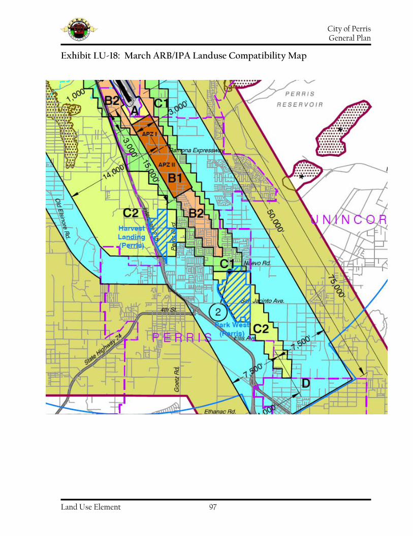
City of Perris General Plan
Land Use Element 97
Exhibit LU-18: March ARB/IPA Landuse Compatibility Map

City of Perris General Plan
Land Use Element 98
Table LU-32: March ARB/IP ALUCP Basic Compatibility Criteria
Table S-5
Zone
Residential (d.u./ac)1
Other Uses (people/ac)2 Req’d
Open Land
Prohibited Uses3
Other Developmental
Conditions4
Average5
Single Acre6
M (Military)
Federal Lands -No ALUC authority
A Clear Zone
(if not base)7
No New Dwellings Allowed
0 0 All
remaining
-All non-aeronautical structures
Assemblages of people
-Objects exceeding FAR Part 77 height
limits -All storage of
hazardous materials -Hazards to flight8
-Electromagnetic radiation
notification -Avigation easement
dedication and disclosure4,7
B1 Inner
Approach/Departure Zone
No new dwellings allowed10
25 (APZ I)
50
(APZ II and outside
APZs)11
100
100
Max. 50% lot
coverage within APZs12
-Children’s schools, daycare centers,
libraries -Hospitals,
congregate care facilities,
hotels/motels, restaurants, places of
assembly -Bldgs with >1 aboveground
habitable floor in APZ I or >2 floors in APZ II and outside of APZs13
-Hazardous materials manufacture/storage14
-Noise sensitive outdoor15
nonresidential uses -Critical community
infrastructure facilities16
-Hazards to flight8
-Uses listed in AICUZ as not
compatible in APZ I or APZ II17
-Locate structures maximum
distance from extended runway
centerline -Sound
attenuation as necessary to meet
interior noise level criteria18
-Zoned fire sprinkler systems
required -Airspace review req’d for objects
>35 ft. tall19
-Electromagnetic radiation
notification9
-Avigation easement
dedication and disclosure4
B2 High Noise Zone
No new dwellings allowed10
100 250 No Req’d
-Children’s schools, day care centers,
libraries -Hospitals,
congregate care facilities,
hotels/motels, places of assembly
-Bldgs with >3
-Locate structures max. distance from
runway -Sound
attenuation as necessary to meet
interior noise level criteria18

City of Perris General Plan
Land Use Element 99
aboveground habitable floors -Noise-sensitive
outdoor nonresidential uses15
-Critical community infrastructure
facilities16
-Hazards to flight8
-Aboveground bulk storage for
hazardous materials
discouraged14,20
-Airspace review req’d for objects
>35 ft. tall19
-Electromagnetic radiation
notification9
-Avigation easement
dedication and disclosure4
C1 Primary
Approach/Departure Zone
< 3.0 100 250 No Req’d
-Children’s schools, day care centers,
libraries -Hospitals,
congregate care facilities, places of
assembly -Noise-sensitive
outdoor nonresidential uses15
-Hazards to flight8
-Critical community
infrastructure facilities
discouraged16,20
-Above ground bulk storage of
hazardous materials
discouraged14,20
-Sound attenuation as
necessary to meet interior noise level criteria18
-Airspace req’d for objects >70 ft.
tall19
-Electromagnetic radiation
notification9
-Deed notice and disclosure4
C2 Flight Corridor Zone
< 6.0 200 500 No Req’d
-Highly noise-sensitive outdoor
nonresidential uses15
-Hazards to flight8
-Children’s schools
discouraged20
-Airspace review req’d for objects
>70 ft. tall19
-Electromagnetic radiation
notification9
-Deed notice and disclosure4
D Flight Corridor
Buffer No Limit
No restriction21 No restriction No Req’d -Hazards to flight8
-Major spectator-oriented sports
stadiums, amphitheater, concert halls discouraged21
-Electromagnetic radiation
notification9
-Deed notice and disclosure4
E Other Airport
Environs No Limit
No restriction21 No restriction No Req’d -Hazards to flight8 -Disclosure only4

City of Perris General Plan
Land Use Element 100
* High Terrain
Same as Underlying Compatibility Zone
Same as Underlying
Compatibility Zone
Not Applicable
-Hazards to flight8
-Other uses restricted in accordance with
criteria for underlying zone.
-Airspace review req’d for objects
>35 ft. tall19
-Avigation easement
dedication and disclosure4
NOTES: Policies referenced here are from the Riverside County Airport Land Use Compatibility Plan adopted by the Riverside County ALUC for other airports beginning in October 2004. A complete copy of the Riverside County Airport Land Use Compatibility Plan is available on the Riverside County Airport Land Use Commission website at www.rcaluc.org. 1. Residential development must not contain more than the indicated number of dwelling units (excluding secondary units) per gross acre. Clustering of units is encouraged provided that the density is limited to no more than 4.0 times the allowable average density for the zone in which the development is proposed. Gross acreage includes the property at issue plus a share of adjacent roads and any adjacent, permanently dedicated, open lands. Mixed-use development in which residential uses are proposed to be located in conjunction with nonresidential uses in the same or adjoining buildings on the same site shall be treated as nonresidential development for the purposes of usage intensity calculations; that is, the occupants of the residential component must be included in calculating the overall number of occupants on the site. A residential component shall not be permitted as part of a mixed use development in zones where residential uses are indicated as incompatible. See Countywide Policy 3.1.3(d). All existing residential development, regardless of densities, is not subject to ALUC authority. 2. Usage intensity calculations shall include all people (e.g., employees, customers/visitors, etc.) who may be on the property at a single point in time, whether indoors or outside. 3. The uses listed here are ones that are explicitly prohibited regardless of whether they meet the intensity criteria. In addition to these explicitly prohibited uses, other uses will normally not be permitted in the respective compatibility zones because they do not meet the usage intensity criteria. See Riverside County Airport Land Use Compatibility Plan, Volume 1, Appendix D for a full list of compatibility designations for specific land uses. 4. As part of certain real estate transactions involving residential property within any compatibility zone (that is, anywhere within an airport influence area), information regarding airport proximity and the existence of aircraft overflights must be disclosed. This requirement is set by state law. See Countywide Policy 4.4.2 for details. Easement dedication and deed notice requirements indicated for specific compatibility zones apply only to new development and to reuse if discretionary approval is required. Avigation easements are to be dedicated to the March Inland Port Airport Authority; the federal government is precluded from receiving easement dedications. See sample language in www.marchjpa.com/docs_forms/avigationeasement.pdf. 5. The total number of people permitted on a project site at any time, except rare special events, must not exceed the indicated usage intensity times the gross acreage of the site. Rare special events are ones (such as an air show at the airport) for which a facility is not designed and normally not used and for which extra safety precautions can be taken as appropriate. 6. Clustering of nonresidential development is permitted. However, no single acre of a project site shall exceed the indicated number of people per acre. See Countywide Policy 4.2.5 for details. 7. Clear zone (equivalent to runway protection zone at civilian airports) limits that delineate Zone A are derived from locations indicated in the March Air Reserve Base AICUZ study. Zone A is on Air Base property or otherwise under military control. 8. Hazards to flight include physical (e.g., tall objects), visual, and electronic forms of interference with the safety of aircraft operations. Land use development that may cause the attraction of birds to increase is also prohibited. Man-made features must be designed to avoid heightened attraction of birds. In Zones A, B1, and B2, flood control facilities should be designed to hold water for no more than 48 hours following a storm and be completely dry between storms (see FAA Advisory Circular 150/5200-33B). Additionally, certain farm crops and farming practices that tend to attract birds are strongly discouraged. These include: certain crops (e.g., rice, barley, oats, wheat – particularly durum – corn, sunflower, clover, berries, cherries, grapes, and apples); farming activities (e.g., tilling and harvesting); confined livestock operations (i.e., feedlots, dairy operations, hog or chicken production facilities, or egg-laying operations); and various farming practices (e.g., livestock feed, water, and manure). Fish production (i.e., catfish, trout) conducted outside of fully enclosed buildings may require mitigation measures (e.g., netting of outdoor ponds, providing covered structures) to prevent bird attraction. Also see Countywide Policy 4.3.7. 9. March ARB must be notified of any land use having an electromagnetic radiation component to assess whether a potential conflict with Air Base radio communications could result. Sources of electromagnetic radiation include microwave transmission in conjunction with a cellular tower, radio wave transmission in conjunction with remote equipment inclusive of irrigation controllers and other similar EMR emissions. 10. Other than in Zone A, construction of a single-family home, including a second unit as defined by state law, on a legal lot of record is exempted from this restriction where such use is permitted by local land use regulations. Interior noise level standards and avigation easement requirements for the compatibility zone in which the dwelling is to be located are to be applied. 11. Non-residential uses are limited to 25 people per gross acre in Accident Potential Zone (APZ) I and 50 people per acre in APZ II and elsewhere in Zone B1. Single-acre intensity limits are 100 people/acre throughout Zone B1. 12. In APZ I, any proposed development having more than 20% lot coverage must not provide on-site services to the public. Zoned fire sprinklers are required. Also, in APZ I, site design of proposed development should to the extent possible avoid placement of buildings within 100 feet of the extended runway centerline; this center strip should be devoted to parking, landscaping, and outdoor storage. Maximum lot coverage is not limited outside the APZs. 13. Within APZ II and outside APZs, two-story buildings are allowed. 14. Storage of aviation fuel and other aviation-related flammable materials on the airport is exempted from this criterion. In APZ I, manufacture or bulk storage of hazardous materials (toxic, explosive, corrosive) is prohibited unless storage is underground; small quantities of materials may be stored for use on site. In APZ II and elsewhere within Zone B1, aboveground storage of more than 6,000 gallons of nonaviation flammable materials per tank is prohibited.

City of Perris General Plan
Land Use Element 101
15. Examples of noise-sensitive outdoor nonresidential uses that should be prohibited include major spectator-oriented sports stadiums, amphitheaters, concert halls and drive-in theaters. Caution should be exercised with respect to uses such as poultry farms and nature preserves. 16. Critical community facilities include power plants, electrical substations, and public communications facilities. See Countywide Policy 4.2.3(d). 17. For properties in either APZ I or II, any use listed as ―N – not compatible‖ for that particular APZ in Table 3-1 of the 2005 Air Installation Compatible Use Zone Study for March Air Reserve Base. Beyond the boundaries of the APZs in Zone B1, such uses are discouraged, but not necessarily prohibited unless otherwise specified herein. 18. All new residences, schools, libraries, museums, hotels and motels, hospitals and nursing homes, places of worship, and other noise-sensitive uses must have sound attenuation features incorporated into the structures sufficient to reduce interior noise levels from exterior aviation-related sources to no more than CNEL 40 dB. This requirement is intended to reduce the disruptiveness of loud individual aircraft noise events upon uses in this zone and represents a higher standard than the CNEL 45 dB standard set by state and local regulations and countywide ALUC policy. Office space must have sound attenuation features sufficient to reduce the exterior aviation-related noise level to no more than CNEL 45 dB. To ensure compliance with these criteria, an acoustical study shall be required to be completed for any development proposed to be situated where the aviation-related noise exposure is more than 20 dB above the interior standard (e.g., within the CNEL 60 dB contour where the interior standard is CNEL 40 dB). Standard building construction is presumed to provide adequate sound attenuation where the difference between the exterior noise exposure and the interior standard is 20 dB or less. 19. This height criterion is for general guidance. Shorter objects normally will not be airspace obstructions unless situated at a ground elevation well above that of the airport. Taller objects may be acceptable if determined not to be obstructions. See Countywide Policies 4.3.3 and 4.3.4. Objects up to 35 feet in height are permitted. However, the Federal Aviation Administration or California Department of Transportation Division of Aeronautics may require marking and lighting of certain objects. See Countywide Policy 4.3.6 for details. 20. Discouraged uses should generally not be permitted unless no feasible alternative is available. 21. Although no explicit upper limit on usage intensity is defined for Zone D and E, land uses of the types listed—uses that attract very high concentrations of people in confined areas—are discouraged in locations below or near the principal arrival and departure flight tracks.