chapter 2 spatial patterns for landslide ecology
TRANSCRIPT

University of Nebraska - LincolnDigitalCommons@University of Nebraska - LincolnUSDA National Wildlife Research Center - StaffPublications
U.S. Department of Agriculture: Animal and PlantHealth Inspection Service
2013
Chapter 2 Spatial patterns for Landslide EcologyLawrence R. WalkerUniversity of Nevada, [email protected]
Aaron B. ShielsUSDA/APHIS/WS National Wildlife Research Center, [email protected]
Follow this and additional works at: https://digitalcommons.unl.edu/icwdm_usdanwrc
Part of the Life Sciences Commons
This Article is brought to you for free and open access by the U.S. Department of Agriculture: Animal and Plant Health Inspection Service atDigitalCommons@University of Nebraska - Lincoln. It has been accepted for inclusion in USDA National Wildlife Research Center - Staff Publicationsby an authorized administrator of DigitalCommons@University of Nebraska - Lincoln.
Walker, Lawrence R. and Shiels, Aaron B., "Chapter 2 Spatial patterns for Landslide Ecology" (2013). USDA National Wildlife ResearchCenter - Staff Publications. 1641.https://digitalcommons.unl.edu/icwdm_usdanwrc/1641

2 Spatial patterns
Key points
1. Remote sensing tools have greatly improved the mapping of both terrestrial and submarine landslides, particularly at global scales. At regional and local scales, environmental correlates are being found that help interpret spatial patterns and related ecological processes on landslides.
2. Landslides are frequent on only 4% of the terrestrial landscape and coverage varies over time because new landslides do not occur at a constant rate.
3. Multiple landslides triggered by the same event, such as an earthquake or severe rainstorm, can vary in physical characteristics. This variety contributes to a mosaic of landslide conditions across the landscape.
4. A landslide environment contrasts with the more stable conditions found in adjacent habitats. The transitions between landslide and adjacent habitats in light, fertility, stability, and other characteristics can be abrupt to gradual, sometimes making it difficult to define where a landslide begins or ends.
2.1 Introduction
The distribution oflandslides is determined by background factors (ultimate causes) such as rock type and soil properties and by immediate triggers (proximate causes) such as rainfall or earthquake occurrence (Dai et al., 2002). While the prediction of the location and timing of a particular landslide remains inexact, mapping of existing landslides at global spatial scales is improving with the use of remote sensing tools such as satellite imagery (Hong et al., 2007). There are also discernible spatial patterns at regional and local scales, driven particularly by the location of landslide triggers (e.g., earthquake epicenters, regions of high rainfall) interacting with topography (Zhou et al., 2002). Within a given landslide,
Published in LANDSLIDE ECOLOGY (New York: Cambridge University Press, 2013), by Lawrence R. Walker (University of Nevada, Las Vegas) and Aaron B. Shiels (USDA National Wildlife Research Center, Hila, Hawai’i). This document is a U.S. government work, not subject to copyright in the United States.

2.2 Where landslides occur . 19
there can also be spatial patterns that influence local ecological processes. The dramatic impacts that landslides have on plants, animals, and soils represent important alterations of the spatial patterns of many ecosystems that can influence future ecosystem processes for decades (Foster et al., 1998).
The consideration of spatial patterns oflandslides can be viewed hierarchically, where smaller-scale patterns driven by local erosion events such as microhabitat heterogeneity are nested within patterns driven at regional to global scales by such processes as succession and tectonic activity (regional to global; Fig. 2.1). Time scales are also considered hierarchically (e.g., larger-scale phenomena are measured on longer time scales). Geomorphological (and ecological) events at a given scale are linked to other scales by the exchange of matter, and energy (O'Neill etal., 1986; de Boer, 1992; Restrepo etal., 2009). Brunsden & Jones (1980) consider such links across scales for landslides occurring on coastal cliffs in southern England during a 100-year period. The average rate of erosion during that time by large, occasional landslides was similar to the rate of erosion by smaller, more frequent landslides. Landslides at these two scales were linked through processes occurring at the cliff bases at intermediate temporal and spatial scales that provided a positive feedback loop between large and small scales. Blocks of eroded cliff rocks from large landslides reduced overall erosion rates and the likelihood of further large landslides but promoted local, smaller scale erosion and the break-up of the large blocks. Meanwhile, many small landslides gradually led to the destabilization of larger portions of the cliffs, increasing the likelihood of a larger landslide occurring during the 100-year period. In this chapter, we consider the distribution oflandslides at global, regional, and local scales, and then discuss how physical attributes of landslides are spatially heterogeneous. This chapter establishes the visually obvious parameters of physical aspects oflandslides, followed in Chapter 3 by the visually less obvious mechanics of how landslides slide and how their soils are altered.
2.2 Where landslides occur
2.2.1 Global scales
Landslides are an occasional feature of over half of all terrestrial landscapes but are only abundant on 4% of the terrestrial surface (Hong et al., 2007). They are most common in the tropics, in earthquake-prone regions, and


2.2 Where landslides occur . 21
where rainfall events tend to be short but intense (Plate 2). Lands bordering the Pacific Ocean (e.g., western South and North America, Kamchatka, Japan, the Philippines, and New Zealand) are earthquake prone and therefore susceptible to landslides where the terrain is sloped (see Chapter 1). Other tectonically active faults include those in Indonesia, northern India, and Tibet. High levels of rainfall and land degradation by dense human populations make eastern China, southern India, eastern Africa, and eastern Brazil particularly susceptible to landslides.
The detection and description of landslides across large spatial scales can be done using a variety of techniques. Aerial photography (particularly with stereoscopic or digital interpretation) has been a standard way to map and monitor landslides (Restrepo et al., 2003). Typical data include estimates of landslide number, local rock type, and regional land use (Singhroy & Molch, 2004). However, the likelihood of finding landslides with aerial photographs decreases with landslide age because vegetation obscures the landform (Turner et al., 2010). More sophisticated tools (e.g., geographical information systems (GIS), laser altimetry (LIDAR), and synthetic aperture radar (SAR)) use inputs from both airplanes and satellites to make remote measurements, even when the landslides are covered by vegetation (McKean & Roering, 2004). Typical parameters that can be measured remotely include landslide number, rock type, size (length, width, depth), distribution of debris types, mass movements over time, and detailed topographic profiles or digital elevation models (Metternicht et al., 2005). Creeping (or slow deformation) of landslide surfaces can also be monitored to help predict when re-sliding will occur (Chadwick et al., 2005). Advances continue to be made in the accuracy of prediction of landslides (see Chapter 6) through the analysis of soil water content using infrared imagery (Carrara et al., 1991), GIS models (Fabbri etal., 2003), and remote mapping of the volumes of potential debris flows (Metternicht et al., 2005).
Submarine landslides move sediments from shallow water to deeper regions of the ocean floor. The source of these sediments is often from erosion of terrestrial surfaces, especially coastal cliffs (Plate 3). Submarine landslides resemble terrestrial landslides in general types (slides and flows) and morphology (slip face, chute, deposition zone) but are often much larger and frequently slide on less steep slopes (Hampton et al., 1996; Elverhoi etal., 2010). Flows are more diverse in submarine than terrestrial landslides and include turbidity currents, which are downhill movements of sediment-laden water (Table 2.1). Submarine landslides most

22 . Spatial patterns
Table 2.1. Classification of submarine landslide types
Type of General movement characteristics
Mass slide Cohesive material, distinct boundary, fluids have minor role
Gravity flow No cohesion, indistinct boundary, fluids have major role
(Modified from Masson et al., 2006).
Nature of movement
Indistinct failure surface
Distinct failure surface
Isolated block collapse
Laminar, mass flow Turbulent flow
Classification of landslide
Creep Slide (translational or
rotational) Debris avalanche
Debris flow Turbidity current
(high or low density)
commonly occur in regions with rapid accumulations of sedimentary deposits and sloping sea floors (Masson et al., 2006). The collapse of sedimentary deposits often generates tsunamis, and biological forces can both destabilize (e.g., by bioerosion) and stabilize (e.g., by providing fungal hyphae) submarine slopes (see Chapter 4; Diaz etal., 1994; Glynn, 1997; Meadows et al., 1994; Walker, 2012). Six locations that provide conditions that promote submarine landslides are discussed below. These locations include fjords, river deltas, submarine canyons, continental margins, areas experiencing changes in sea level, and volcanic islands.
First, fjords, or glacially eroded valleys inundated by the sea, have sediment-rich inputs from glacial melt water that create unstable debris fans on the steep submarine slopes. The 1964 earthquake in Alaska, for example, resulted in several types of landslides where debris fans had accumulated sediments that were several hundred meters deep in the 7000 years since the glaciers that carved the fjords had receded. These accumulated sediments collapsed as debris falls and debris flows (Lee et al., 2006). Fjord-related landslides are also common throughout the North Atlantic Ocean and are generally limited by the geomorphology of the channel with widths up to 0.5 km, slip faces matching the height of accumulated sediments, and shallower deposition zones because the sediments tend to dissipate through turbidity currents (Hiihnerbach & Masson, 2004).

2.2 Where landslides occur . 23
Second, submarine river deltas are created at the mouths of silt-rich rivers. Some are subject to slope failure, particularly where heavy loads of relatively coarse sediments build upon already unstable, finer sediments. River delta landslides have been found at the mouths of the Mississippi (U.S.) and Yellow (China) Rivers (Prior & Coleman, 1980; Prior et al., 1986; Hampton et at., 1996). The absence of landslides in other sediment-rich river deltas (e.g., the Yangtze and Pearl Rivers, China, and the Columbia River, U.S.) suggests that other triggers are needed. Such triggers might include earthquakes, hurricanes (that can affect water currents to 100 m depth; Henkel, 1970), or decaying organic material that destabilizes sediments through the production of methane gas (Nisbet & Piper, 1998).
Third, submarine canyons are conducive to submarine landslides, especially when they have steep, incised walls. Common ways to determine if submarine canyons are locations for landslides are to look for debris fans and displaced blocks at their outlets, or losses of sediments following storms or earthquakes (Malo uta et al., 1981).
Fourth, the slopes along continental margins can produce landslides, and there are many examples from around the world (Plate 4; Piper et al., 1985; Hampton et at., 1996). Many of these coastal landslides produce turbidity currents, which can deposit organically rich sediments in deeper ocean water (Fig. 2.2; Heezen etat., 1955a). Earthquakes are presumably the cause of most of these landslides, but this has only occasionally been documented (e.g., for the 220 km3 Grand Banks landslide near Nova Scotia in 1929; Fine et al., 2005).
Fifth, changes in sea level are presumed to be important in generating submarine landslides, resembling conditions in reservoirs where water level fluctuations within short time intervals can trigger landslides. Changes in temperature and pressure accompanying the lowering of sea level can generate gas bubbles (especially methane) in sediment layers and, as the gases are released, slopes can become destabilized (Kayen & Lee, 1991). Gas hydrates released at the base of a continental shelf are associated with eroding continental slopes (Crutchley et al., 2007). Such zones of instability can experience repeated landslides for thousands of years, as demonstrated off the California coast (Greene etat., 2006).
Sixth, submarine landslides are common on slopes of young, active volcanoes, and other tectonically active parts of the sea floor (Whelan & Kelletat, 2002). On the Island of Hawaii, lava flows have

(a)
(b)
Cape Verde
~ Islands '.,.. , •
.• \6
Tenerife
Debris avalanche (age in years)
< 200 . 200 - 600 • >600
Fig. 2.2. Submarine landslides in the eastern Atlantic Ocean off the African coast. (a) Debris avalanches, debris flows, and turbidity currents; and (b) details of debris avalanches around the Canary Islands with approximate ages of formation. From Masson etal. (2006) with permission from The Royal Society (U.K.).
2.2 Where landslides occur . 25
built mountains that are up to 9 km tall (5 km of which is submarine) (Lipman et al., 1988). There appears to be a two-way, causal relationship between magma and landslides, because landslides can modify the location and eruption dynamics of volcanoes and magma displacement can trigger landslides (Moore et al., 1989). Submarine (and terrestrial) landslides are also found on older volcanoes wherever slopes are destabilized (Fig. 2.2). Earthquakes are common causes of landslides but also can be caused by landslides (e.g., on submarine volcanic slopes; Hampton et al., 1996).
The detection of submarine landslides is a relatively new endeavor. Submarine landslides can now be detected remotely using side-scan sonar, acoustic signals, and swath-bathymetry systems (Hampton et al., 1996). Submarine landslides can also be deduced from evidence of deformed sediments in cores of the ocean floor or by terrestrial deposits of marine sediments purported to come from submarine-triggered tsunamis. Examples of the latter come from Hawaii and Scotland. On the south coast of Lanai, Hawaii, gravel deposits reach an elevation of 326 m a.s.l. and contain skeletons of reef organisms presumed to have been brought there by three separate landslide-induced tsunamis (occurring approximately 105000 years ago; Moore & Moore, 1984). In Scotland, diatom-rich deposits of fine sands 4 m a.s.l. are likely to have originated from a tsunami in the North Atlantic triggered by the second Storegga landslide about 7000 years ago (Fig. 2.3; Box 2.1; Long etal., 1989). Other methods of detection of submarine landslides come from interactions with man-made features. For example, landslides broke submarine telegraph cables off the coast of Newfoundland in 1929 (Heezen et al., 1955a); harbor facilities were lost in Alaska (U.S.), British Columbia (Canada), Norway, and France; and offshore drilling platforms were disrupted in the Gulf of Mexico (Hampton et al., 1996). The 1964 earthquake in Alaska triggered many landslides in Anchorage (Fig. 2.4; Box 2.2) and caused a submarine landslide that removed 75 million m 3 of the harbor at Valdez (Coulter & Migliaccio, 1966). Submarine landslides can also cause earthquakes (Lipman et al., 1985), as well as being caused by earthquakes, so there are multiple avenues to pursue in detecting and studying them. Submarine landslides differ in many intriguing ways from terrestrial ones (e.g., they have much longer run-outs on shallower slopes; Elverhoi et al., 2010), so detection is the first step to increasing our understanding of them.
Landslides also occur in freshwater ecosystems, triggered mostly by river bank erosion but also by abrupt changes in water levels, particularly

26 Spatial patterns
Fig. 2.3. The huge submarine Storegga landslide (black) off the west coast of Norway, which occurred about 7000 years ago. The westernmost, finger-like deposits are from turbidity currents. Other large landslides in the North Atlantic Ocean are shown in light grey. Contour lines of ocean depth in m. From Haflidason et al. (2004) with permission from Elsevier.
in lakes and reservoirs. Landslides can affect freshwater ecosystems by the deposition of sediments that alter flow dynamics and the contours of stream and lake beds (Schuster, 2001). Most (e.g., 80%) of the sediment in some rivers comes from landslides, as demonstrated in the Rocky Mountains, Idaho, U.S. (Wilson et al., 1982) and in Puerto Rico

2.2 Where landslides occur . 27
Box 2.1 Storegga: a massive submarine landslide
Recent advances in remote sensing of submarine landslides are showing just how unstable the ocean floor can be, particularly along continental margins. One of the largest submarine landslides ever measured is Storegga ("Great Edge"), located 100 km off the coast of Norway. It is so large that it reaches half the distance from Norway to Greenland (Fig. 2.3), or nearly the length of the U.K. The first of five phases (Elverhoi et al., 2010) was the most massive and occurred about 30000-50000 years ago; it created a slide that had enough volume (about 4000 km3
) that it would have covered Alaska 2 m deep and left a scar the size of the state of Maryland (U.S.; Nisbet & Piper, 1998). The second phase mostly occurred on the surface produced by the first event and was composed of a series oflandslides in rapid succession (about 6000-8000 years ago) that had a total volume between 2400 and 3200 km3 and covered about 95000 km2
(Haflidason etal., 2004). The remaining three phases were shorter and smaller in volume and continued the erosion toward the coast of Norway. The slip face (headwall) of the second phase was 310 km long and the landslides together had a run-out distance of 41 0 km of debris and another 400 km of turbidite (from turbidity currents). One of the landslides moved two blocks, each lOx 30 km in size, 200 km downslope. These landslides were caused by layers of clay-rich sediments deposited from ocean currents (contourites) that become unstable when under great pressure from layers of glacial sediments (Masson etal., 2006). The tsunami created by the second event deposited sediments in Scotland and probably destroyed early human populations on the now submerged land between Denmark and the U.K. called Doggerland.
(Larsen & Torres-Sanchez, 1992). Sediment loads in rivers depend in part on the width of the floodplain, because narrow valleys are more likely to funnel landslide sediments directly into the river (Fig. 2.5) than are wide valleys where (terrestrial) debris fans can accumulate (May & Gresswell, 2004). The input of sediments from landslides can occur quickly through rock avalanches and debris flows or more slowly through slumps and earth flows (Swanston, 1991). Rapid additions of sediments to rivers can increase flood damage downstream, particularly when rivers are already swollen from high levels of precipitation. The damage from

28 Spatial patterns
_ _ _ _ ~-~kE!..Plu!!..!in~
\ Swale pond
y ~ Current bluff
Cook Inlet
(a)
(b)
Fig. 2.4. The Alaskan earthquake of 1964 and coastal slumping around Anchorage. (a) Artistic rendering of the slump at the edge of the coast of the Cook Inlet (horizontal displacement = several hundred meters; vertical displacement = 11 m, so horizontal scale collapsed relative to vertical scale); (b) current bluff displaced about 11 m downward into the Inlet; (c) swale pond created after the displacement. See Box 2.2 for details. Drawing modified from sign provided by the City of Anchorage. Both photographs by L.R. Walker.
earthquake-triggered landslides on the Reventador Volcano in Ecuador in 1987 was largely from flooding that was aggravated by sediments from the many landslides (Nieto & Schuster, 1991). Landslides also provide a critical conduit of organic matter and nutrients (particularly phosphorus) to freshwater ecosystems (see Chapter 3).

2.2 Where landslides occur 29
(c)
Fig 2.4. (cant.)
FiR. 2.5. Landslide entering the Yangtze River in Tiger Leaping Gorge, Yunnan Province, China. Photograph by X. Yang.

30 . Spatial patterns
Box 2.2 The Alaska earthquake of 1964
On 27 March 1964, southern Alaska experienced a powerful earthquake that registered 9.2 on the Richter Scale, making it the second most intense earthquake ever recorded. With its epicenter on land 125 km east of Anchorage, it caused soilliquifaction, fissures, and many landslides; over 130 people were killed. The port of Valdez, 64 km east of the epicenter, lost its entire port to a large, submarine landslide and subsequent 12 m tall tsunami. Tsunamis caused additional damage as far away as Japan. Marine clays (Bootlegger Cove Clay) deposited by glaciers over many centuries in the Cook Inlet liquified along the coast of Anchorage. A bluff (2500 x 350 m) composed of more recent sediments overlying the clay (Naptowne Outwash) slid with the clay several hundred meters seaward (Fig. 2.4), depositing over 12 x 106 m3 of sand, gravel, and clay into the ocean. Large areas of forests and wetlands were destroyed, but new habitats were created, including swale ponds. The vertical displacement of about 11 m was not limited to the Cook Inlet, but affected a 250 000 km2 area of Alaska.
Sometimes landslides dam rivers, especially in steep-walled, narrow canyons where minimal landslide volume is required (Schuster, 1995). Dams rearrange sediment deposits in the floodplain (Mackey etal., 2011), and can trigger further landslides upstream of the dam, particularly if water levels drop quickly when the dam is breached (Kojan & Hutchinson, 1978). Downstream, landslides can also occur during the flash flood following a breach. The amount of sediment transported during a dam failure can be substantial; 3 000 000 m3 of sediment was deposited 700 m downstream after a 100 m tall landslide dam was breached on the Toro River in Costa Rica (Mora etal., 1993). Most landslide dams are short-lived, with about 90% failing within 1 year (Costa & Schuster, 1991). For example, when the Dadu River in China was danuned by a landslide in 1786, water pooled behind it and it broke 10 days later (Li, 1989). The debris flow that resulted extended 1400 km downstream and killed about 100000 people (Schuster, 2001). Other landslide dams can last for centuries to millennia. Lake Waikaremoana on the NQrth Island, New Zealand is 250 m deep and was formed by a landslide 2200 years ago (Riley & Read, 1992). The 1911 Usoi

2.2 Where landslides occur . 31
landslide in the Pamir Mountains of Tajikistan created the still extant, 500 m deep Lake Sarez (Gasiev, 1984). If the Usoi landslide dam were to fail, the resulting flood could affect 2100 km of floodplain - all the way to the Aral Sea (Schuster, 2002). Long-lived landslide dams can provide clues about past climates. For example, in northwestern Argentina, sediments in lakes that formed from landslide dams between 40 000 and 25000 years ago have been used to suggest past environmental conditions of increased humidity and more pronounced seasonality, conditions which are generally associated with reduced thresholds for landsliding (Trauth & Strecker, 1999).
2.2.2 Regional scales
At regional levels, several studies have quantified the spatial extent of landslides over time using various tools (Table 2.2). Time intervals for these studies ranged from decades to several centuries over areas from several to hundreds ofkm2
• The area affected by landslides in these studies (usually expressed as a percentage of the land affected per century) ranged from 0.01% to 15%, although subsets of these examples had over 50% of the land area affected where landslides were most dense. Studies that focused on small areas prone to landsliding had higher percentages of land affected than studies of larger areas; extrapolations using small study areas could therefore be misleading. Although rainfall was the most common trigger in these examples, earthquakes were also important. Return intervals of landslides to a specific site were not always calculated, but in the mountains of Mexico and Central America, return intervals ranged from 75-500 years; more land was affected at low than at high elevations and in wet than in dry forests (Restrepo & Alvarez, 2006). The average size of landslides alters the percentage of land affected. For example, in eastern Puerto Rico, 41 rainstorms between 1960 and 1990 created 1100 landslides, but their total coverage was not large due to their generally small size (Larsen & Torres-Sanchez, 1996). The median size of a landslide was larger (220 m2
) on hill slopes affected by roads than those affected by crops or pasture (70 m2
). Similarly, the mean area oflandslides on Oahu, Hawaii, was only 291 m2 and landslides affected a relatively small percentage of the measured land area (Peterson et ai., 1993). The rate of landslide formation varies over time. For example, on the North Island, New Zealand, landslides covered 1.7% of a catchment in 1946 but 2.7% in 1963, likely due to increased rainfall coupled with overgrazing by


2.2 Where landslides occur . 33
1930 1940 1950 1960 1970 1980
Decade
Fig. 2.6. Landslide occurrence on Oahu, Hawaii varied by decade, largely due to rainfall patterns. From Peterson et al. (1993).
introduced animals Games, 1973). In Hawaii, large variations in the number of landslide per decade were attributed to rainfall patterns (Fig. 2.6; Peterson et al., 1993).
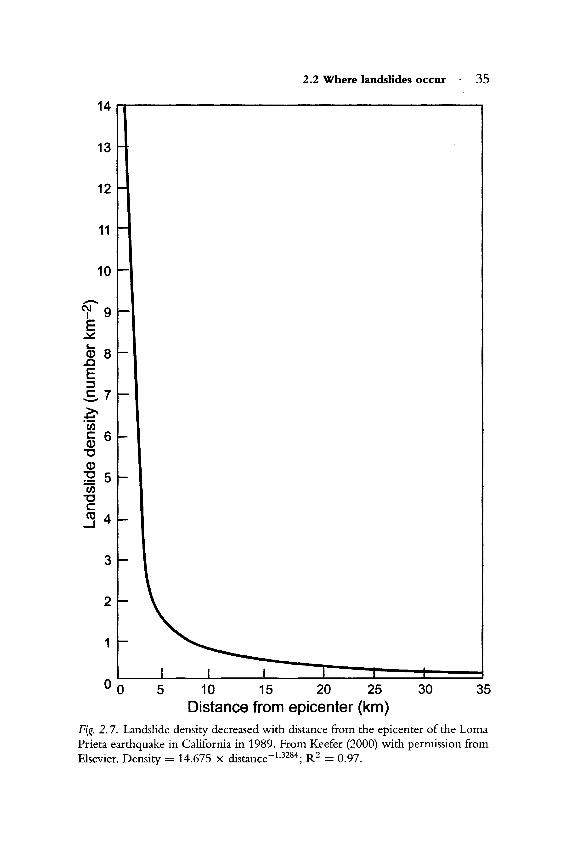
Many landslides can be generated by a single trigger event (Table 2.3), although the landslides may be quite distinct in size and density, due to underlying environmental correlates. Landslides created in 1989 in Puerto Rico during Hurricane Hugo, for example, ranged in size from 18 to 4500 m 2 (Larsen & Torres-Sanchez, 1992) and density from 0.8 landslides km-2 in drainage basins furthest from the path of the hurricane to 15 km-2 in drainage basins closest to the hurricane. Landslide densities also vary across a landscape, typically decreasing exponentially with distance from the earthquake epicenter (Fig. 2.7). For example, landslide densities on bluffs along the Mississippi River in Missouri and neighboring states (U.S.) declined with distance from the epicenter of the 1811-1812 New Madrid earthquake Gibson & Keefer, 1989). Similar concentrations around earthquake epicenters were found in two California earthquakes in 1989 (Keefer, 1994; 2000) and 1994 (Parise & Jibson, 2000). Additional explanations of the spatial distributions of landslides come from lithology, topography, aspect, and vegetation. Landslides created by a 1929 earthquake in New Zealand were most frequent and largest on mudstone and siltstone, particularly along rock folds and steep

2.2 Where landslides occur . 35
14~--------------------------------------~
13
12
11
10
3
2
1
5 10 15 20 25 30 35 Distance from epicenter (km)
Fig. 2. 7. Landslide density decreased with distance from the epicenter of the Lorna Prieta earthquake in California in 1989. From Keefer (2000) with permission from Elsevier. Density = 14.675 x distance-1.3284; R2 = 0.97.

36 . Spatial patterns
scarps, and least common and smallest on granite and sandstone (Pearce & O'Loughlin, 1985). Unconsolidated sediments and sedimentary rocks were most erosion prone during earthquakes in 1994 (California; Parise & Jibson, 2000) and 1999 (Taiwan; Khazai & Sitar, 2003). Steep slopes are nearly universally more susceptible to sliding than flatter ones, if all other characteristics are similar. Aspect can influence landsliding when slopes exhibit distinct geological formations or when an earthquake features directional differences in seismic shaking (Pearce & o 'Loughlin, 1985). In addition, aspect can be a factor when slopes are differentially exposed to relatively horizontal rain, as occurred during Hurricane Hugo in Puerto Rico (Larsen & Torres-Sanchez, 1992). Finally, vegetation cover can provide variable resistance to erosion, as it did in the northwestern U.S. in 2007 when slopes with intermediate-aged forests were most resistant to landsliding during heavy rainstorms combined with snowmelt (Turner et al., 2010). Landslides formed during a single event are therefore quite distinct except for their age.
2.2.3 Local scales
The local distribution of landslides has several environmental correlates, including rock and soil types, topography, climate, and vegetation (Table 2.3). Rocks of sedimentary origin and unconsolidated sediments are most likely to erode (see Chapter 3), while geological faults and areas of folding are also susceptible. Steep slopes, valley headwalls, scarps from former landslides, and undercut cliffs along river channels are some of the topographical features that promote landslides. Rainfall is the principal climatic variable that influences landslide distributions and it is affected by topography, elevation, and vegetation, factors which are all interrelated. Mountain ranges cause air currents to ascend and cool, resulting in increasing precipitation with elevation. Losses of water from vegetation to the air (evapotranspiration) also increase humidity and therefore rainfall. The sudden loss of foliage from Puerto Rican forests following Hurricane Hugo, for example, contributed to a temporary increase in the elevational belt of high rainfall (Scatena & Larsen, 1991). Mountains also provide rain shadows on the leeward side of the prevailing winds because air masses warm up as they descend and thereby moisture is removed from the air. Therefore, leeward slopes may be less prone to landsliding because they are drier than windward slopes. Most landslides in northeastern Puerto Rico, for example, are on north- and north-east-facing slopes (Larsen & Torres-Sanchez, 1996), which are most exposed to the

2.3 Spatial heterogeneity . 37
prevailing northeasterly trade winds. In contrast, south-facing slopes had fewest landslides during three large storms (Shiels & Walker, in press). Within a slope prone to landsliding, smaller scale variations in slope and vegetation can be influential in determining whether or not a given portion of the slope erodes. Most landslides do not create homogeneous patches of mineral soil, but instead result in complex surfaces representing a mosaic of erosion rates.
2.3 Spatial heterogeneity
2.3.1 Gaps and patchiness
Landslides create spatial heterogeneity in landscapes and are also internally heterogeneous. The sharpest contrast at both levels is between landslide habitats and adjacent, unaffected habitats. Landslides initially form a gap with more light and bare soil and less vegetation than the undisturbed matrix. Thus, a gradient of resources is created where early successional organisms find refuge. There can also be contrasts among and within landslides. Across a landscape prone to hill slope erosion, there may be several to many landslides differing in size and age. Landslides of similar age may have resulted from a single earthquake or heavy rainstorm (see Section 2.2.2) and form "populations" of landslides (Fig. 2.8). Many of these populations created during different triggering events can be considered "communities" of landslides across wider spatial scales (Restrepo et al., 2009). Landslides within populations may be more similar to each other than to those in other populations, thus forming regional heterogeneity within landslide communities. Alternatively, within-population variability in size, aspect, elevation, or other physical characteristics is also possible. Landslides within a population are also likely to diverge (become more distinct) in their biological characteristics during succession because of their scattered distribution, variation in remnant soil or vegetation, and local dispersal dynamics (Restrepo & Alvarez, 2006; Walker etal., 2010b; see Chapter 5). A mountainous region with landslides is therefore a patchwork of habitats differing in soil, vegetation, and successional stage (Pickett & White, 1985). This patchwork influences regional distributions of nutrients, organic matter, and vegetation, and landslides are important as agents of transfer of these elements from ridges to valleys (see Chapter 3; Restrepo et al., 2003; Walker & Shiels, 2008).
Local heterogeneity is provided both by the distinct change from landslide to undisturbed matrix along landslide edges and by the patchiness of

38 Spatial patterns
Fig. 2.8. Multiple earthquake-induced landslides in the Avoca River drainage of the Southern Alps, New Zealand. Photograph by 1~J. Bellingham.

2.3 Spatial heterogeneity . 39
Fig. 2.9. Landslide edges are accompanied by often abrupt changes in microsite conditions; Puerto Rico. Photograph by A.B. Shiels.
habitats within most landslides. Increased light levels are the most obvious physical alteration when a landslide occurs in a forested landscape; landslide-forest borders are generally intermediate in light levels (Myster & Fernandez, 1995). The increase in light levels within a landslide parallels increases found in forest gaps created by treefalls and hurricanes (Chazdon & Fetcher, 1984; Denslow et al., 1990; Fernandez & Fetcher, 1991). Light levels on landslides can be reduced by tall canopies in adjacent forests, an aspect that reduces exposure to the sun (Fernandez & Myster, 1995), and by rapid re-growth of vegetation, especially when it produces dense thickets (Walker, 1994; see Chapter 5). Light quality is also altered within landslides, where red:far red ratios are increased compared to adjacent forest edges and forests (Fig. 2.9); these changes have implications for plant colonization, generally favoring germination of early successional species (Vazquez-Yanes & Smith, 1982).
The interior of a landslide derives its heterogeneity from the dynamics of erosion (Hansen, 1984b). Landslide scars often resemble amphitheaters because they have a generally rounded and convex upper boundary (crest) and a rounded, concave lower area (Plate 5). However, those
40 . Spadal patterns
landslides that are elongated do not resemble an amphitheater. The steepness of a landslide is partly determined by the erosion resistance of the underlying bedrock and partly by surface erosion factors such as water flow. Standardized descriptions of landslides help compare variable landslide surfaces. Typical measurements include the width, length, and depth of the rupture and the displaced mass as well as the total length of the landslide (IAEG Commission on Landslides, 1990). Volumes can then be estimated (Fort et al., 2010) based on spoon-shaped models of half an ellipsoid, but such estimates become more problematic when landslide pathways are elongated or irregular in shape.
Terrestrial landslides generally have a recognizable slip face (also called a failure scar or scarp) at the top that is usually a steep, occasionally vertical headwall. The top of the slip face where it meets undisturbed substrate above is called the crown (Plate 6; see Fig. 1.1; Cruden & Varnes, 1996). The entire area that slides is sometimes called the source area (Brunsden, 1984) where most soils are removed and few nutrients remain. The zone of depletion is a related term that indicates where a landslide has lowered the original ground surface. The next discernible feature of most landslides is a chute (or zone of depletion) that is typically the narrowest part of the landslide and it is often clearly delineated from the stable slopes on either side by steep sheer zones (Plate 6). Finally, there is usually a deposition zone where the slope decreases sharply and the transported material stops (see front cover image; Fig. 1.5). The deposition zone can be characterized by lobes of successive flows that often spread out horizontally and where the ground level is raised from its original level. The foot is the area where eroded material has moved beyond the area of rupture and spread onto new ground. The foot can be quite extensive and include portions of both the chute and deposition zones. The mix of vegetation, topsoil, and subsoil that has slid down slope and stopped in the deposition zone provides an area of relatively high fertility when compared to the slip face and chute. Sometimes the end (toe) of the deposition zone is removed by wave action (at the ocean shore), currents (in a river), or bulldozers (on a road).
2.3.2 Sizes and shapes
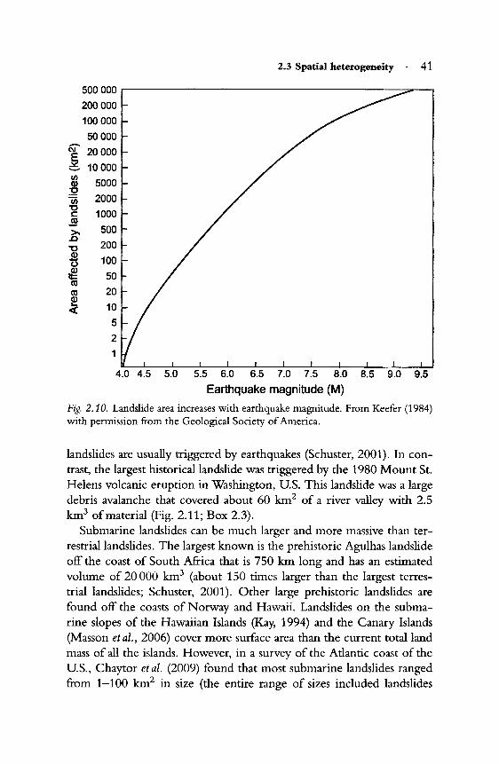
Terrestrial landslides can vary from slumps of only 10-20 m2 to massive disruptions of whole valleys or mountainsides reaching as much as 500 000 km2 (Fig. 2.10; Keefer, 1984). The largest landslides are prehistoric and include some with volumes up to 135 km3; such large

42 Spatial patterns
Fig. 2.11. Debris flow of the North Fork of the Toutle River, 24 years after the 1980 eruption of Mount St. Helens, Washington (U.S.). This is the largest recorded terrestrial debris flow. See Box 2.3 for details. Photograph by L.R. Walker.
0.9-2410 km2) and 0.1-10 km3 in volume (entire range: 0.002-179 km3). The elongation of submarine landslides is sometimes due to turbidity currents (dense currents of suspended sediments) down continental slopes, even when the slopes are only slightly inclined (Nisbet & Piper, 1998).
Although large landslides affect more surface area than small landslides, they are usually less frequent (Guariguata, 1990; Dalling & Iremonger, 1994) and therefore may contribute less total sediment erosion than small landslides (Stark & Hovius, 2001). However, large landslides can also contribute more erosion, depending on the group of landslides one compares. For example, in a comparison of the volumes of twelve South American landslides that occurred during the twentieth century, seven were < 10 x 106 m3, five were 10 x 106-99 X 106 m3 , and only two were > 1000 x 106 m3 (Schuster et al., 2002). The largest (2000 x 106 m3) was the result of failure of a landslide dam, and it approximated the volume of the Mount St. Helens debris avalanche. Several other recent landslides

2.3 Spatial heterogeneity . 43
Box 2.3 Toutle River landslide: the world's largest recorded debris avalanche
Mount St. Helens is the best known and most studied volcano in the u.S. It erupted in May 1980 and dramatically altered the once heavily forested landscape, in part through the destruction caused by the world's largest historical debris avalanche (area: 60 km2, volume: 2.5 km3). One of the lobes of the avalanche entered and passed through a lake, creating a new lake that was larger and shallower. A second lobe overtopped a ridge that reached over 380 m above the lake. A third lobe swept 23 km down the North Fork of the Toutle River in about 10 minutes, erasing existing vegetation and soils and radically altering the region's hydrology. The river valley was transformed into a poorly sorted, hummocky terrain of sand and gravel that was 10-195 m deep (mean: 45 m) (Swanson & Major, 2005). New lakes were formed where tributary streams were blocked. Most of the debris had little organic matter or soil, although some was deposited at the landslide margins and terminus. Over the next few years, the loose debris began to erode and deep new drainage channels were carved out that provided drainage for both entrapped ground water and new inputs from precipitation. Within 10 years, 35% of the surface had been altered into channels and terraces (Meyer & Martinson, 1989). Ponds formed between some of the 30 m tall hummocks and have become centers for plant colonization (Fig. 2.11; Crisafulli et al., 2005). A landslide that caused great landscape changes has become one of the much-studied features of the Mount St. Helens eruption.
have had estimated volumes of 1000-2000 x 106 m3 (e.g., Tajikistan in 1911; New Guinea in 1988), but most are much smaller (Sidle & Ochiai, 2006).
Landslides are typically longer than they are wide (see Fig. 1.7). In a study of over 2000 landslides in Hong Kong, horizontal length varied from 5-785 m (mean = 43 m; Dai & Lee, 2002). Slopes (in conjunction with rainfall patterns and soil structure) largely determine the location of the initial landslide, but the surrounding topography (slopes, ridges, valleys, lakes) continues its influence on the velocity of the sediments and
44 . Spatial patterns
the final shape of the landslide through its effects on re-sliding. Abrupt decreases in slope can slow sediment loss and, where not constrained by valley walls, cause debris fans to spread out over the land surface. Short landslides occur when there is a small volume of soil dislodged from the slope, a sudden decrease in slope, or opposing slopes or structures that restrict sediment flow. On a similar slope, flows normally travel further than falls, while slides are intermediate in length. Short landslides fall, slide, or flow only 5-10 m, while some landslides can travel hundreds to thousands of meters (Schuster et al., 2002).
2.3.3 Gradients
The spatial heterogeneity oflandslide surfaces is pardy a mosaic of clearly defined patches but it is also a combination of abiotic and biotic gradients. Changes in physical and abiotic conditions on landslides and between landslides and their matrix can be initially abrupt, but more often they are gradual, producing indistinct gradients between landslide and nonlandslide surfaces. A fresh landslide scar can be hotter, drier, better lit, more unstable, and less fertile than the surrounding vegetated matrix. However, designating the actual edges of a landslide can be a challenge, especially at smaller scales. Does a landslide begin where there is 0%, <25%, or <75% of the original vegetative cover? Or should landslide edges be defined by soil removal and deposition, thereby disregarding vegetative cover? Are islands of soils and vegetation that survived the landslide or rafted down from the top to be considered as a part of the landslide? Are branches of canopy trees that overhang a part of the landslide a part of the landslide, particularly if tree roots are growing into the landslide soil? How deep do mineral soil deposits over the top of undisturbed soil (e.g., at the base of a landslide) have to be to be included as part of the landslide? A similar problem arises with volcanic ash that can vary in depth from several millimeters to many meters (Zobel & Antos, 1991). The spatial gradients on a landslide are complex and affect not only attempts to draw boundaries or categorize habitats, but also the temporal dynamics of a landslide (Myster & Fernandez, 1995; Fetcher et al., 1996). For example, fertile soils and surviving organisms in the deposition zone often accelerate ecological succession on landslides compared to the less fertile patches of a landslide (see Chapter 5; Walker et al., 1996). The boundaries of within-landslide patches and the shapes of entire landslides can also vary with time, because sharp edges erode, nutrients are rearranged, plants grow, and animals return.

2.4 Conclusions . 45
2.4 Conclusions
Landslides are distributed around the world wherever there are slopes and at least one trigger such as an earthquake, an intense rainfall, recent volcanic activity, or a construction project. Landslides also can trigger earthquakes, tsunamis, and floods and even modify the eruption patterns of volcanoes. Therefore, landslides are closely linked to many other types of disturbances. Their spatial characteristics at regional and global scales have been much easier to assess since the advent of high-resolution remote-sensing imagery and GIS technology (Keefer & Larsen, 2007). Advances are also being made in the detection and mapping of submarine landslides. Landslides can occur irregularly and often re-slide (Shiels &
Walker, in press), so multi-year studies give a better picture of their importance in the landscape. When many landslides are triggered by the same event, they can be considered a population of landslides, but these landslides may vary greatly from each other in size, shape, aspect, and successional recovery trajectories. The local distribution of landslides is affected by topographical and climatic features, including aspect, slope, and rainfall.
Landslides contribute to a heterogeneous patchwork of gaps that influences many subsequent geological and biological processes. Multiple landslide shapes and sizes add variety to this patchwork. The stark differences between a landslide and a stable slope include changes in light and soil conditions. These changes can be abrupt, or gradual, providing many gradients of stability, fertility, and light levels. This spatial complexity provides a rich and fascinating variety of habitats in which to study ecological processes.