circulation - california
TRANSCRIPT

.
CHAPTER NINE
CIRCULATION


Granite Bay Community Plan CIRCULATION
Page | 111
9. Circulation The purpose of the circulation chapter of the Granite Bay Community Plan is to set forth goals, policies and implementation programs that will provide a transportation system that serves the future needs of the community and has the following qualities:
• Accommodates pedestrian, equestrian and cyclist needs
• Establishes level of service goals • Retains and enhances rural and
scenic qualities of the area • Provides “Scenic” and “Country”
roads • Accommodates new development
projects • Reduces impacts on air quality • Improves safety • Balances local and county priorities • Optimally utilizes available funds • Identifies adequate funding sources for recognized needs
The transportation system plays a major role in shaping the form, character and growth of a community. There is a s trong interaction between the availability of adequate transportation facilities, and decisions about the direction of growth and the uses of land along with their spatial distribution and density of development. 9.1 GOALS AND POLICIES The County is committed to the provision and enhancement of an efficient transportation system. The Circulation Element envisages the harmonious integration of all modes and elements of transportation with a long-term vision to provide a ‘balanced transportation system’ that is accessible to all members of the Granite Bay community including persons with disabilities. GOAL
1. To provide a balanced system of roadways that ensure safe and efficient movement of local and through traffic, accommodate area growth, retain the area’s rural and scenic qualities, and accommodate pedestrian and cycle traffic.
Objectives: 1. Accommodates pedestrian, equestrian and cyclists 2. Establishes level of service goals 3. Retains rural and scenic qualities of the area 4. Accommodates development 5. Provides for designated “Scenic” and “Country” roadways 6. Balances local and County priorities 7. Improves safety
Figure 9.0.1: Two-lane roads contribute to the rural atmosphere of Granite Bay.

CIRCULATION Granite Bay Community Plan
Page | 112
POLICIES 1. The County shall plan, design and r egulate roadways in accordance with the functional
classification system shown on the Circulation diagram and the typical cross sections included in the Community Plan.
2. The rights-of-way for roadways shall be wide enough to accommodate appropriate road paving, trails, paths and bikeways, drainage, public utility services, and substantial trees and shrubs.
3. The level of service (LOS) on major roadways (i.e., arterial and collector routes) and intersections shall be at Level "C" or better during the A.M. and/or P.M. peak hour. The exceptions to this are intersections along Auburn-Folsom from Douglas Boulevard southerly, and along Douglas Boulevard from Auburn-Folsom Road westerly, where the level of service shall be LOS “E” or better during the A.M. and/or P.M. peak hour.
4. The intersection of Douglas Boulevard and Sierra College Boulevard shall have a LOS goal of “E” or better. The County shall work towards providing LOS E at this location until all reasonable improvements (three through lanes, two left turn lanes and a separate right turn lane on all approaches) are made. It is recognized that after all reasonable improvements have been made that the LOS may become worse than LOS “E” during the A.M. and/or P.M. peak hour.
5. Land development projects shall be approved only if LOS C (or the exception cited earlier) can be achieved on roads and intersections after: a) traffic from approved projects has been added to the system, and b) improvements funded by the capital improvement program (CIP) have been constructed. This will result in temporary slippage of the LOS below the adopted standards until adequate funding has been collected for the construction of CIP improvements.
6. The County shall plan and implement a complete road network to serve the needs of local traffic. This network shall include low-speed roadways parallel to regional facilities to allow local circulation without requiring the use of regional facilities.
7. "Through" traffic that must pass through the community shall be accommodated in a manner that will not encourage the use of residential or private roads. T hrough traffic shall be d irected to Douglas Boulevard, Auburn-Folsom Road and Sierra College Boulevard. These routes provide access to Folsom Lake from all directions, and provide a through north-south route as well as a west-south route.
8. The County shall work with neighboring jurisdictions and t he Regional Transportation Planning Agencies to develop alternative routes for through traffic, as this through traffic has significant impacts on roads in the Granite Bay community.
9. Street lights, traffic signals and signs should be used only where essential or practical for safety purposes or for efficient traffic flow.
10. Through trucks shall be limited to Auburn-Folsom Road, Douglas Boulevard and Sierra College Boulevard.
11. Scenic or conservation easements over properties adjacent to the roadway shall be a condition of approval of new development on designated Scenic or Country Roadways to ensure preservation of a vista from the road and to preserve the natural, rural character of the community.
12. When major construction is proposed on any of the arterial roadways designated as a Scenic Roadway, the County shall request the establishment of an Underground Utility District to place utilities underground to protect and enhance the scenic qualities of the roadway unless the County presents justification for not making such a r equest. A ll new developments shall be required to have underground utilities.
13. Meandering paths, separated from the roadway, shall be used in lieu of sidewalks in all developments with a parcel size of 0.9 acres or more and shall be encouraged in developments with parcel sizes of 0.4 acres or more.
14. Contouring and planting of cut-and-fill slopes shall be an integral part of the road design and construction process; effective planting of these slopes with trees, shrubs, and groundcover is necessary for erosion control and to restore the scenic quality of the road corridor.
15. Designated Scenic or Country Roadways shall be established and shall have specific development rules to maintain their scenic and country qualities.
16. Roadway surfacing shall be performed in accordance with accepted pavement management strategies within the guidelines for Scenic and Country Roadways and the constraints of limited financial resources.

Granite Bay Community Plan CIRCULATION
Page | 113
17. Non-residential properties shall be interconnected to allow traffic to circulate freely between such adjacent properties.
18. Roads with two or more lanes in each direction shall have a raised landscaped median unless findings are made for not having the median on any given roadway.
19. New freeways or expressways shall not be considered, planned or permitted within the Plan area east of Sierra College Boulevard and north of East Roseville Parkway.
20. As development or construction occurs at the intersection of Douglas Boulevard and Auburn-Folsom Road, each of the four approaches to the intersection shall include standardized raised medians unless the County can present justification for not including standardized raised medians at these locations. Vegetation shall be incorporated if sufficient space is available, or cobblestone should be used if space for vegetation is not adequate.
21. The community's desire to retain the character of the Country Roadways and the design guidelines for Country Roadways shall be earnestly considered when designing improvements to arterial or collector roads designated as Country Roadways. The County shall strive for a balance between local community desires and engineering solutions and shall present proposed designs to the community for review prior to approval. Upgrades made to minor arterial and c ollector roads designated as Country Roadways should be limited to critical safety issues and sufficient shoulder for cyclists and pedestrians.
22. No new driveways should be added to any arterial roadway unless it is the only access available to a parcel. An exception to this requirement may be granted where there is a planned stop sign or traffic signal on the arterial adjacent to the parcel.
23. A map creating new parcels should not be a pproved if it creates parcels requiring access to a major arterial roadway (see Table 9.7.1).
24. The County shall pursue regional, state and federal monies to fund needed transportation capital improvements.
25. Roadway projects shall avoid, minimize or appropriately mitigate adverse environmental impacts on natural heritage features, functions and linkages.
26. Ensure the provision of adequate and accessible road, transit, pedestrian and cycle links between Granite Bay and adjacent communities.
27. Roadway design should complement and enhance surrounding land use and community character.
28. To help preserve the rural character of Granite Bay and promote interconnectivity between neighborhoods, gated subdivisions shall only be allowed under the following circumstances: a. Instances in which the entrance is located adjacent to a substantial traffic generator (i.e.
regional park, church or school) that creates a parking issue within the subdivision; or, b. Instances in which the entrance to the subdivision is contiguous to or accessed through a
non-residential land use such as a business/professional or commercial use, and separating the uses with a gate is the most practicable solution; or,
c. Is directly accessed off a major arterial roadway (see Table 9.7.1).
29. Even if the circumstances listed in Policy 28 above are demonstrated, gates are only allowed where a neighborhood is surrounded by existing development making thru road connections to adjoining neighborhoods impractical to achieve.
Any gated entrance thus conditionally approved must incorporate into its construction and design the following: a. The private road and gate shall not preclude, compromise or deny convenient and
practical (including any other non-motorized forms of movement) access into a neighborhood that features public amenities (i.e. public park) and/or places (i.e. public open space or school); and,
b. Unrestricted pedestrian access shall be maintained from dawn to dusk either through a public easement or other mechanism; and,

CIRCULATION Granite Bay Community Plan
Page | 114
c. The private gated entrance design shall allow for adequate paved turn-around and keypad/callbox setback from the public right-of-way per the Engineering and Surveying Department’s recommended design detail; and,
d. The proposed gate and entrance features conform to the landscaping, setback and design guidelines outlined in the Community Design Section 4.2.6; and,
e. The road to be gated shall be privately maintained, and any irrevocable offer of dedication to Placer County and/or for a public road easement over the private road easement is properly abandoned; and,
f. The subdivision has a recorded maintenance provision for the gate and frontage and perimeter landscape/improvements, i.e. a Homeowner’s Association or Road Maintenance Agreement; and,
g. Continuous 24-hour access is provided for all public safety, utility service and public support providers including egress for the public in evacuation situations.
GOAL 2. Local and inter-area public and private transit shall be encouraged and transportation systems
management strategies shall be applied to reduce peak-period traffic, total vehicle miles traveled, reduce impact on air quality, improve level of service, and improve safety.
Objectives: 1. Reduces impact on air quality 2. Improves safety 3. Establishes level of service goals 4. Balances local and County priorities
POLICIES
1. Placer County shall work with the cities of Roseville, Rocklin and Folsom to investigate transit service linking these communities in a m anner that will reduce auto traffic through the Granite Bay area.
2. Bus stop turnouts shall be required at appropriate locations as conditions of approval of development.
3. Park-and-Ride areas shall be r equired at appropriate locations as conditions of approval of development.
4. Other facilities or programs to encourage ridesharing will be planned to reduce traffic growth. 5. Placer County shall work with major traffic generators (such as Folsom Lake State Recreation
Area, schools, employment centers, etc.) to manage traffic in an efficient manner. 6. The County shall work with PCTPA and other agencies to promote measures that increase auto
occupancy and decrease single occupant automobile use. 7. During the development review process, the County shall require that land development projects
meet adopted trip reduction ordinance requirements. 8. The County shall continue to work with regional transit providers for delivery and coordination of
public transit needs, including intermodal facilities if necessary. 9. County officials shall work closely with Folsom Lake State Recreation Area management to
develop and implement strategies to minimize the impact of State Park visitors on local roads and residents.

Granite Bay Community Plan CIRCULATION
Page | 115
GOAL 3. A Capital Improvement Program (CIP) and other funding mechanisms shall be developed to
provide for the transportation system.
POLICIES 1. The County shall annually report to the Granite Bay Municipal Advisory Council on transportation
issues affecting the community and efforts to deal with community traffic problems. This report shall discuss such issues as traffic counts, road improvements, air pollution concerns (Spare the Air days), traffic management strategies, intersection improvements, speed zoning, financing (fee revenue and expenses), and planned roadway projects and trails development.
2. The County shall develop and administer a C apital Improvements Program (CIP) that contains roadway improvements necessary to achieve level of service standards defined in this Plan.
3. Capital improvements shall be undertaken in response to development of the area. 4. On-site and " frontage" improvements of land development projects shall be r equired as
conditions of approval for all land development projects. 5. Traffic mitigation fees to fund the CIP described in this Plan shall be required as a condition of
approval for all land development projects within the Plan area. 6. Improvements that enhance safety shall be given a high priority. After considering community
recommendations, the Placer County Board of Supervisors shall determine priority and scheduling of projects from the CIP.
7. All new traffic signals or modifications to existing traffic signals shall incorporate emergency vehicle preemption.
8. The County shall develop and administer a CIP that implements the prioritized trails and Class I paths included in the Community Plan.
GOAL 4. Provide safe and comfortable routes for walking, cycling, and public transportation to encourage
use of these modes of transportation, enable convenient and active travel as part of daily activities, reduce pollution, and meet the needs of all users of the streets.
POLICIES
1. The Engineering and Surveying Department and the Department of Public Works shall view all transportation improvements as opportunities to improve safety, access, and mobility for all travelers and recognize cycling, pedestrian, and transit modes as integral elements of the transportation system.
2. Integrate Complete Streets infrastructure and design features into street design and construction to create safe and inviting environments for all users.
3. Consider the accessibility and accommodation of cycle and pedestrian traffic, where appropriate, on and across major thoroughfares.
CIRCULATION Granite Bay Community Plan
Page | 116
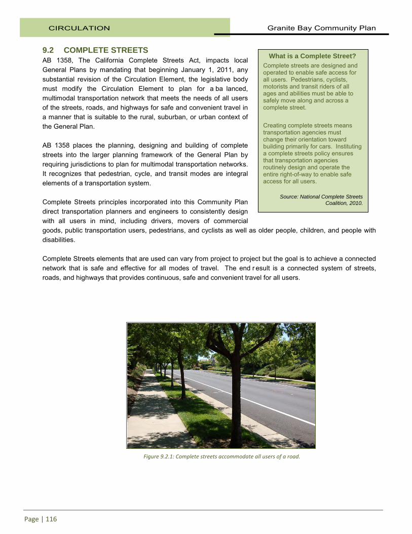
9.2 COMPLETE STREETS AB 1358, The California Complete Streets Act, impacts local General Plans by mandating that beginning January 1, 2011, any substantial revision of the Circulation Element, the legislative body must modify the Circulation Element to plan for a ba lanced, multimodal transportation network that meets the needs of all users of the streets, roads, and highways for safe and convenient travel in a manner that is suitable to the rural, suburban, or urban context of the General Plan. AB 1358 places the planning, designing and building of complete streets into the larger planning framework of the General Plan by requiring jurisdictions to plan for multimodal transportation networks. It recognizes that pedestrian, cycle, and transit modes are integral elements of a transportation system. Complete Streets principles incorporated into this Community Plan direct transportation planners and engineers to consistently design with all users in mind, including drivers, movers of commercial goods, public transportation users, pedestrians, and cyclists as well as older people, children, and people with disabilities. Complete Streets elements that are used can vary from project to project but the goal is to achieve a connected network that is safe and effective for all modes of travel. The end r esult is a connected system of streets, roads, and highways that provides continuous, safe and convenient travel for all users.
What is a Complete Street? Complete streets are designed and operated to enable safe access for all users. Pedestrians, cyclists, motorists and transit riders of all ages and abilities must be able to safely move along and across a complete street. Creating complete streets means transportation agencies must change their orientation toward building primarily for cars. Instituting a complete streets policy ensures that transportation agencies routinely design and operate the entire right-of-way to enable safe access for all users.
Source: National Complete Streets
Coalition, 2010.
Figure 9.2.1: Complete streets accommodate all users of a road.

Granite Bay Community Plan CIRCULATION
Page | 117
9.3 EXISTING TRANSPORTATION SYSTEM The transportation system that currently serves the Granite Bay community includes a network of streets and highways, cycle lanes, multiple use trails, public transit and park-n-ride facilities. The existing conditions of each of these components of the transportation network are discussed in this section.
Streets and Highways The most prominent feature of the existing transportation network is the system of local and regional roadways that serve the Community Plan area. This is obviously due to the predominance of automobile travel in serving the community’s transportation needs. The network of streets and highways that serve a community is ordered in a hierarchical fashion, ranging from local streets intended to serve only adjacent land uses to freeways that are intended to serve only long distance, high speed travel and provide no access to adjacent properties. In between these two extremes are collector and arterial roadways. Roadways serve two conflicting purposes from a design standpoint: to provide mobility and to provide access to adjacent land uses. High and constant speed is desirable for mobility, while access to adjacent land uses is accomplished at low speeds. The functional classification of roadways serves to emphasize the functional design requirements of a r oadway. Local facilities emphasize the land access function and arterial roadways emphasize a hi gh level of mobility for through traffic and collector roadways offer a m ore balanced service to both functions. Only at the extremes of the functional classification system do r oadways serve an exclusive function: a c ul-de-sac serves a land access function only and does not serve any through traffic; a f reeway serves only through traffic and provides no l and access function. Between these two extremes, the functional classification of a roadway more realistically represents the function of a roadway within a continuum between the land access emphasis of a local road and the higher speed mobility emphasis of an arterial roadway. A description of the roadway functional classification is presented below.
Figure 9.3.1: Douglas Boulevard.
Figure 9.3.2: A Median is used for aesthetic reasons and as a traffic-calming measure along East Roseville Parkway.

CIRCULATION Granite Bay Community Plan
Page | 118
Freeways Freeways are multi-lane roadways that serve to move people and goods long distances at high speeds. No direct access to adjacent properties is allowed or provided. Rather, access to freeways is provided via access ramps that connect to local and regional surface streets. All crossings of freeways are grade separated to alleviate any conflict with through travel on the freeway. Arterial Roadways Arterial roadways are streets and highways that function to move traffic at relatively high speeds between major activity centers and from collector roadways to freeways. A secondary and subordinate purpose of an arterial roadway is to provide access to abutting properties. T he public uses these roadways as primary circulation routes for through traffic, and they carry higher volumes of traffic than local streets and collector roadways. In urban/suburban areas, major arterials will generally carry higher traffic volumes than minor arterials and thus require more right-of-way and have more access restrictions. Rural arterial roadways may or may not carry high traffic volumes, but do provide primary access routes for travel into, out of, and through the rural areas of the community. Collector Roadways Collector roadways are intended to “collect” traffic from local streets and carry it to roadways higher in the street classification hierarchy (e.g., arterials). The public uses these roadways as secondary circulation routes, and they generally carry light to moderate traffic volumes. Access to abutting land is normally permitted, but may be restricted to certain uses dependent upon future traffic volumes. I n urban/suburban areas, major collector roadways will generally carry higher traffic volumes than minor collectors and thus require more right-of-way and have more access restrictions. Local Streets Local streets provide direct access to abutting land, and access to the collector street system. Residents and the public use these streets for local circulation. They carry little, if any, through traffic, and generally carry very low traffic volumes. 9.4 EXISTING ROADWAY CONDITIONS Traffic Operations Traffic operating conditions on streets and highways and at intersections are quantified in terms of “level of service”, or LOS. LOS is a qualitative measure of the effect of a number of factors which include speed and travel time, traffic interruptions, freedom to maneuver, safety, driving comfort and convenience and operating costs. LOS is expressed as a letter grade, ranging from LOS “A” to LOS “F” and r epresenting progressively worsening traffic operating conditions. LOS “A” can be characterized as free-flow traffic conditions with little or no delay. LOS “F” on the other hand represents forced traffic flow conditions often
Figure 9.4.1: Local streets may be either public or private.

Granite Bay Community Plan CIRCULATION
Page | 119
characterized by excessive delays. LOS at intersections is quantified for a one-hour period- typically either the A.M. or P.M. peak hour.
To provide a foundation for assessing future traffic conditions in the Granite Bay area, the existing LOS for major roadways and intersections has been determined. The LOS at major intersections is provided in Table 9.4.1 and the LOS for major roadways is provided in 9.4.2. It is important to understand that LOS for a roadway segment and LOS for an intersection are based on different criteria. LOS for an intersection is based on turning movements, lane geometries, intersection control and hourly volumes. LOS for a roadway segment is based on daily traffic volumes, the number of lanes and generalized volume thresholds derived from typical traffic distribution curves. Therefore, the LOS for an i ntersection and for a r oadway segment are not directly comparable, with the intersection LOS typically better reflective of traffic operating conditions. As shown in Tables 9.4.1 and 9.4.2, existing traffic congestion and delays are focused in the Sierra College Boulevard, Douglas Boulevard and Auburn-Folsom Road areas of Granite Bay. The majority of the Community Plan area presently enjoys good traffic operating characteristics, reflected by the predominance of LOS A and B conditions.
Table 9.4.1 Existing Level of Service
Intersection Level of Service Date
Auburn-Folsom Road at Eureka Road E 2002 Auburn-Folsom at Oak Hill Road E 2002 Auburn-Folsom at Fuller Drive D 2002 Barton Road at Eureka Road C 2001 Douglas Blvd at Auburn-Folsom Road E 2002 Douglas Blvd at Barton Road C 2001 Douglas Blvd at Berg Street D 2001 Douglas Blvd at Cavitt-Stallman South C 2000 Sierra College Blvd at Douglas Boulevard F 2002 Sierra College Blvd at Cavitt-Stallman Road E 2000 Sierra College Blvd at Olympus A 2000 Cavitt-Stallman Road at Olive Ranch Road A 2000 Laird Road at Wells Avenue A 2000

CIRCULATION Granite Bay Community Plan
Page | 120
Table 9.4.2 Existing Average Daily Traffic and Level of Service
Roadway Segment ADT* LOS
Auburn-Folsom Road Sacramento Co Line to Eureka 26,500 F Eureka to Douglas 23,200 F Douglas to Joe Rodgers 15,800 D Joe Rodgers to Cavitt-Stallman 10,200 A Cavitt-Stallman to Dick Cook 5,300 A
Barton Road Sacramento Co. to East Roseville 2,400 A Eureka to Douglas 5,000 A Olive Ranch to Cavitt-Stallman 2,200 A
Berg Street Douglas to Olive Ranch 700 A
Cavitt-Stallman Road Sierra College to Cavitt-Stallman South 4,000 A Cavitt-Stallman South to Olive Ranch 4,800 A Olive Ranch to Barton 550 A Barton to Laird 1,200 A Laird to Auburn-Folsom 3,200 A
Cavitt-Stallman South Cavitt-Stallman to Douglas 3,100 A
Dick Cook Road Val Verde to Auburn-Folsom 500 A
Douglas Blvd. Sierra College to Cavitt-Stallman South 30,900 D Cavitt-Stallman South to Seeno 32,000 D Seeno to Barton 28,400 C Barton to Auburn-Folsom 28,300 C Auburn-Folsom to Folsom Lake 7,900 A
East Roseville Pkwy Roseville City Limits to Wellington 10,400 A Wellington to Elmhurst 9,500 A Elmhurst to Elmhurst 8,600 A
Eureka Road Hillsborough to Wellington 7,500 A Wellington to Barton 4,400 A Barton to Auburn-Folsom 4,900 A
Joe Rodgers Road Douglas to Auburn-Folsom 1,400 A
Laird Road South of Wells 2,500 A North of Cavitt-Stallman 3,800 A
Old Auburn Road West of Sierra College Blvd 9,500 B
Olive Ranch Road Cavitt-Stallman to Berg 2,500 A Berg to Barton 2,000 A
Sierra College Blvd. Sacramento Co Line to Old Auburn 19,500 F Old Auburn to East Roseville 20,000 A East Roseville to Eureka 20,000 A Eureka to Douglas 22,800 B Douglas to Cavitt-Stallman 11,000 A Cavitt-Stallman to Olympus 10,000 A
Val Verde Road Wells to Dick Cook 1,000 A
Wells Avenue Loomis Town Line to Laird 1,400 A Laird to Val Verde 900 A
*ADT=Average Daily Traffic

Granite Bay Community Plan CIRCULATION
Page | 121
Scenic and Country Roadways A major goal of the Granite Bay community is to preserve the “rural nature” of the Plan area. Within the context of the Circulation Element, this desire is expressed in the concept of designating, retaining, maintaining and developing “Scenic” and "Country” roadways. Scenic Roadways are those roads that traverse areas that provide an aesthetically pleasing view of natural vegetation, wildlife habitat, natural geologic features, wetlands, parks, vistas or open space. They can also be areas where natural scenic qualities have been disturbed or deteriorated to a point that landscaping must be des igned and installed to re-establish their scenic qualities. The following roads in the Granite Bay community are designated as Scenic Roads: • Auburn-Folsom Road, south of Douglas Boulevard commercial area • Douglas Boulevard • Barton Road, south of Douglas Boulevard commercial area • Cavitt-Stallman Road, south of Olive Ranch Road • East Roseville Parkway
Country roadways are those designated two lane roads that traverse areas of predominantly large acreage or large lots, low density housing, orchards, ranches, farms, wetlands, geologic features, open space, and s tands of trees and s hrubs. Many of these roadways have developed over time, resulting in roadways that are not built to current highway design standards. As such, roadway widths are often substandard, but they also often possess scenic qualities as horizontal and vertical curves that follow the “lay of the land” and divert around such obstacles as rock outcroppings and t rees. It is the intent of this Plan to retain the character of these roads, but also to encourage targeted widening to improve safety for all road users.
Figure 9.4.3: Scenic and Country Roadways help preserve the rural nature of Granite Bay.
Figure 9.4.4: Country roadways typically do not have sidewalks.

CIRCULATION Granite Bay Community Plan
Page | 122
The following collector roads in the Granite Bay community are designated as Country Roadways: • Cavitt-Stallman Road, from Olive Ranch Road to Auburn-Folsom Road • Barton Road, north of Douglas Boulevard commercial area • Eureka Road • Wells Avenue • Laird Road • Val Verde Road • Dick Cook Road • Olive Ranch Road • Berg Street • Auburn-Folsom Road, north of the Douglas Boulevard commercial area
Scenic and Country Roadways normally do not have sidewalks or curbs and gutters, although there are exceptions to this such as Douglas Boulevard and in areas where parcel sizes are less than 0.9 acres. Meandering paths of a native material and paved shoulders take the place of sidewalks and roadside ditches handle drainage needs. Streetlights are kept to a minimum and are generally only provided at major intersections or where specific significant safety issues make lighting essential. Homes and b uildings along Scenic and Country Roadways are usually set back from the roadway a distance substantially greater than the minimum dictated by the Zoning Ordinance. For specifics on design characteristics along Scenic and Country Roadways, see the Community Design section. 9.5 PUBLIC TRANSPORTATION The following provides a discussion of the transit services provided within Granite Bay, and two adjacent jurisdictions that provide transit services which influence travel patterns within Granite Bay. Placer County Transit. There are no established transit routes in Granite Bay. The community is currently served by a demand responsive public transit system. It is operated by the Consolidated Transportation Services Agency (CTSA) under contract to Placer County Transit (PCT). Service is provided Monday through Friday. The service transports patrons to the Sierra Gardens Transfer Center in the City of Roseville where linkages to other PCT routes and to Roseville Transit are available. Western Placer Consolidated Transportation Services Agency. The Placer County Transportation Planning Agency (PCTPA) has designated the Western Placer Consolidated Transportation Service Agency as the
Figure 9.5.1: Placer County Transit does not provide regular service to Granite Bay.

Granite Bay Community Plan CIRCULATION
Page | 123
Consolidated Transportation Service Agency (CTSA) to serve western Placer County, which includes the Granite Bay community. As defined by California law, a CTSA is an agency that coordinates and/or provides transportation services for a particular region. T his may include services for the elderly and individuals with disabilities who cannot use conventional transit services. Since June 2008, the CTSA has developed a p ublic/private partnership (Transit Operator Working Group, Seniors First and its key partners) to run three pilot programs that are intended to serve elderly persons and persons with disabilities who are unable to use conventional public transit services. They are described as follows:
1. Health Express – This program is a non-emergency medical transportation service that is provided by
Seniors First.
2. Volunteer Door-to-Door Transportation – This service is intended for individuals who are not able to use conventional public transit services.
3. Transportation Vouchers – This program is intended to provide vouchers for members of the community to ensure that essential non-emergency medical transportation needs of elderly persons and persons with disabilities are met. Seniors First is responsible for evaluating and approving each volunteer request.
These pilot programs operated until December 31, 2010. Based upon an evaluation, it was decided to continue the programs. Roseville Transit. The City of Roseville operates Roseville Transit, providing a comprehensive system of fixed route services throughout the city as well as a D ial-A-Ride service and a commuter service to downtown Sacramento. The commuter service operates eight express routes into downtown Sacramento and back Monday through Friday during peak commute hours. Dial-A-Ride is operated throughout the city to serve persons with specialized transportation needs. Fixed route service is provided on eight routes operated throughout the city and provides connections to adjoining transit service providers (Placer County Transit (PCT) and Sacramento Regional Transit (RT)). Van Pool Program. Placer County Transit offers a vanpool program to Placer County residents. PCT provides a 7, 12 or 15 passenger van to qualified drivers. The driver is responsible for soliciting riders and collecting monthly fares from riders. Insurance, maintenance and vehicle leasing is provided by PCT. PCT assists in promoting vanpools to attract riders. Park-N-Ride. Within the Granite Bay community, Placer County has started to develop Park-N-Ride facilities in conjunction with land development projects that include large parking lots - usually commercial or office development. This is done as a condition of approval of discretionary land use permits and the facilities take the form of joint-use parking spaces that can be used for Park-N-Ride purposes.
Figure 9.5.2: Dial-a-Ride service is available in Granite Bay.
CIRCULATION Granite Bay Community Plan
Page | 124
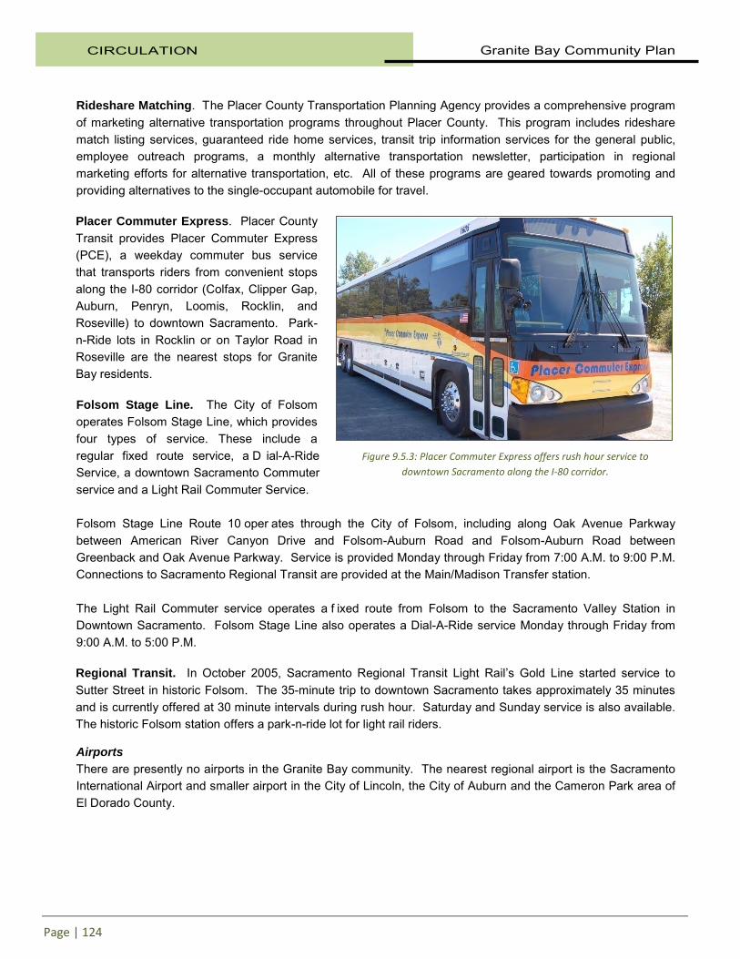
Rideshare Matching. The Placer County Transportation Planning Agency provides a comprehensive program of marketing alternative transportation programs throughout Placer County. This program includes rideshare match listing services, guaranteed ride home services, transit trip information services for the general public, employee outreach programs, a monthly alternative transportation newsletter, participation in regional marketing efforts for alternative transportation, etc. All of these programs are geared towards promoting and providing alternatives to the single-occupant automobile for travel. Placer Commuter Express. Placer County Transit provides Placer Commuter Express (PCE), a weekday commuter bus service that transports riders from convenient stops along the I-80 corridor (Colfax, Clipper Gap, Auburn, Penryn, Loomis, Rocklin, and Roseville) to downtown Sacramento. Park-n-Ride lots in Rocklin or on Taylor Road in Roseville are the nearest stops for Granite Bay residents. Folsom Stage Line. The City of Folsom operates Folsom Stage Line, which provides four types of service. These include a regular fixed route service, a D ial-A-Ride Service, a downtown Sacramento Commuter service and a Light Rail Commuter Service. Folsom Stage Line Route 10 oper ates through the City of Folsom, including along Oak Avenue Parkway between American River Canyon Drive and Folsom-Auburn Road and Folsom-Auburn Road between Greenback and Oak Avenue Parkway. Service is provided Monday through Friday from 7:00 A.M. to 9:00 P.M. Connections to Sacramento Regional Transit are provided at the Main/Madison Transfer station. The Light Rail Commuter service operates a f ixed route from Folsom to the Sacramento Valley Station in Downtown Sacramento. Folsom Stage Line also operates a Dial-A-Ride service Monday through Friday from 9:00 A.M. to 5:00 P.M. Regional Transit. In October 2005, Sacramento Regional Transit Light Rail’s Gold Line started service to Sutter Street in historic Folsom. The 35-minute trip to downtown Sacramento takes approximately 35 minutes and is currently offered at 30 minute intervals during rush hour. Saturday and Sunday service is also available. The historic Folsom station offers a park-n-ride lot for light rail riders. Airports There are presently no airports in the Granite Bay community. The nearest regional airport is the Sacramento International Airport and smaller airport in the City of Lincoln, the City of Auburn and the Cameron Park area of El Dorado County.
Figure 9.5.3: Placer Commuter Express offers rush hour service to downtown Sacramento along the I-80 corridor.

Granite Bay Community Plan CIRCULATION
Page | 125
9.6 FUTURE TRANSPORTATION SYSTEM
Roadways To assess future roadways needs in the Granite Bay community, projections of future traffic conditions for the year 2020 were developed. These projections were developed using a travel demand model developed as part of the Southeast Placer Transportation Study. A travel demand model translates growth in future residential development (single and multi-family housing units) and non-residential development (represented by estimates of the square footage by development type, plus the number of enrolled students) into projections of traffic on arterial and collector roadways throughout Placer County. The County’s travel demand model covers Placer, Sacramento, El Dorado and Yolo counties as well as South Sutter County. Thus, the model captures the impacts of regional growth on traffic demand in the Granite Bay community. Estimates of the growth in residential and non-residential development between 1999 and 2020 in Placer County are based on general plan land use densities and the best estimates of market absorption from each local jurisdiction. Estimates of 2020 development outside of Placer County are based on projections prepared by the Sacramento Area Council of Governments (SACOG). Table 9.6.1 shows the estimated growth in the Granite Bay Community Plan area as well as surrounding communities that was used to forecast improvements needed in the transportation system. Much of Granite Bay is zoned for rural residential/low density uses and is already close to “buildout.” Residential uses in the study area will reach buildout levels before 2020 with an increase in population of about 6,300, which represents a 39 percent increase over 1999 levels. Non-residential land in the study area is limited to a few areas, primarily near Sierra College Boulevard and Auburn-Folsom Road intersections with Douglas Boulevard. Employment within the study area is expected to increase by 1,100 between 1999 and 2020, an increase of about 42 percent. While available land and low zoning densities will limit growth within the study area over the next 20 years, a tremendous amount of growth is expected in communities surrounding Granite Bay. As shown in Table 9.6.1, an additional 42,000 and 31,000 people are expected to be l iving in the cities of Roseville and Rocklin respectively by 2020. The combined population of 177,000 for those two cities represents a 70 per cent increase over 1999 levels. Western El Dorado County and Folsom are expected to add 56,000 and 28,000 residents over the next 20 years, respectively. Employment in Roseville and Rocklin is expected to increase even faster than their population, with an estimated 77,000 jobs added by 2020. The number of jobs in western El Dorado County and Folsom is expected to nearly double by 2020. The large amount of growth that is expected in communities east and west of Granite Bay will result in a large increase in commuting through the Granite Bay community. Table 9.6.1 is presented only to provide a benchmark of growth and development in the Granite Bay area versus surrounding area. This data was derived from socio-economic forecasts prepared by SACOG in 1999. The travel demand modeling uses different socio-economic data- such as number of dwelling units rather than population - also developed by SACOG.

CIRCULATION Granite Bay Community Plan
Page | 126
Table 9.6.1 Projected Population and Employment Growth 1999-2020
Population Employment
Community 1999 2020 Total
Growth %
Growth 1999 2020
Total Growth
% Growth
Granite Bay Comm. Plan area 16,229 22,505 6,276 38.7% 2,604 3,698 1,094 42.0%
Horseshoe Bar Area 7,286 10,510 3,224 44.2% 535 890 355 66.4%
City of Folsom 41,109 69,164 28,055 68.2% 19,219 31,537 12,318 64.1%
El Dorado Hills 18,454 64,740 46,286 250.8% 5,517 17,539 12,022 217.9%
Cameron Park 26,260 36,353 10,093 38.4% 4,568 8,724 4,156 91.0%
Subtotal Folsom/ West El Dorado
85,823 170,257 84,434 98.4% 29,304 57,800 28,496 97.2%
City of Roseville 72,273 114,731 42,458 58.7% 47,804 107,219 59,415 124.3%
City of Rocklin 31,741 62,844 31,103 98.0% 11,777 29,826 18,049 153.3%
Subtotal Roseville/Rocklin 104,014 177,575 73,561 70.7% 59,581 137,045 77,464 130.0%
Source: Sacramento Area Council of Governments, 1999
Note: The population and employment numbers, and resulting traffic volume projections, contained within this table were considered accurate when utilized in the Circulation update in 2002. Development proposals will be required to
utilize current population, employment and traffic volumes to determine impacts and mitigations.
See Table 2.2.2 for an updated Granite Bay Population Projection.
Figure 9.6.1: Aerial of Granite Bay. Sierra College and Douglas Boulevard at bottom right. Image courtesy of Jeff Glazner.

Granite Bay Community Plan CIRCULATION
Page | 127
Growth in Through Travel The Placer County travel demand model was used to estimate the amount of “through traffic” (trips that have neither their origin nor destination within the study area) that uses study area roadways. The model’s estimate of the origins and destinations of traffic on Auburn-Folsom Road illustrates the magnitude of change anticipated between 1995 and 2020. The model estimates that in 1995 just over half of the vehicles on Auburn-Folsom Road at the County line (about 9,000 out of 17,500 daily vehicle trips) had one end of their trip within the study area (i.e. within Granite Bay or the Horseshoe Bar communities). The other 8,500 daily vehicle trips were “through traffic.” By 2020, the amount of “through traffic” on that section of roadway is expected to grow by 17,300 daily vehicle trips, an increase of 204 percent. Local study area traffic using Auburn-Folsom Road at the County line is expected to increase by only about 2,100 daily vehicle trips over 1995 levels, or about 23 percent. Evaluation of 2020 Roadway Network The travel demand model was used to develop traffic projections for 2020 in the Granite Bay community. Analysis of the community under 2020 conditions indicates that there will be significant congestion along Douglas Boulevard and Eureka Road. The analysis also concludes that there would not be significant traffic congestion issues on study area roadways north of Douglas Boulevard. Numerous community-wide forums were conducted during preparation of the Southeast Placer Transportation study. The community overwhelmingly supported no further widening of Douglas Boulevard or Eureka Road to deal with the influx of through trips in Granite Bay. I n response to these community desires, the Southeast Placer Transportation Study recommended that no additional lanes be added to either Douglas Boulevard or Eureka Road. Rather, the study recommends improvements to key intersections along both Douglas Boulevard and Eureka Road. This is due to the fact that the performance of the major street system is dictated largely by the ability of major intersections to handle peak hour traffic flows. It must be understood that the traffic projections for Southeast Placer, and Granite Bay in particular, are based on long-range plans (residential and non-residential development) and were developed using computer simulation programs. Development plans can change and the degree of accuracy of long-range projections is uncertain. For these reasons, the Southeast Placer Transportation Study recommends that right-of-way along Douglas Boulevard be pr eserved for six lanes and the right-of-way along Eureka Road (Wellington Way to Auburn-Folsom) be preserved for four lanes. This provides an opportunity to re-assess roadway needs in the future. Figure 9.6.2 shows the projected 2020 daily traffic volumes on the major roadways in the Granite Bay community.

CIRCULATION Granite Bay Community Plan
Page | 128
Figure 9.6.2: Future Traffic Projections.

Granite Bay Community Plan CIRCULATION
Page | 129
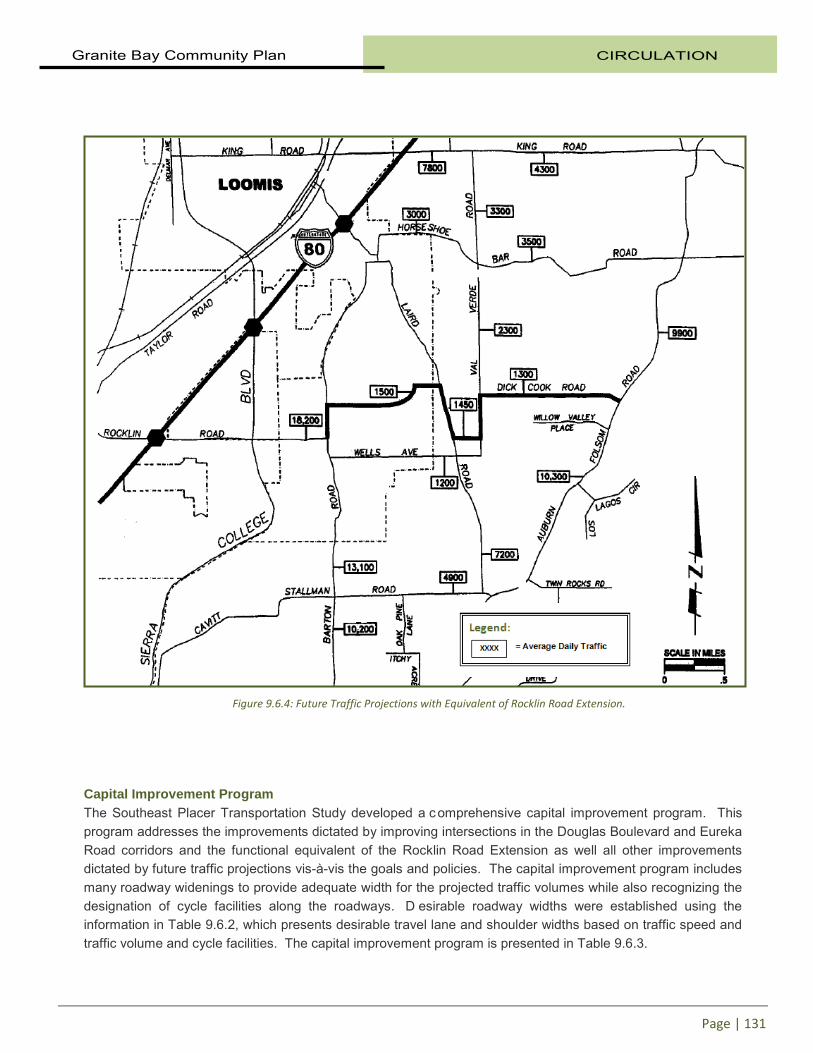
The level of service policies set forth earlier were developed to provide a balance between providing good traffic operating conditions on roadways and intersections in Granite Bay and accommodating through traffic. Level of service E has been established as the level of service goal for major intersections along Auburn-Folsom Road and Douglas Boulevard. This service level recognizes that congestion will occur during the peak travel hours. This congestion is acceptable only as a lesser of two evils. In other words, a higher level of service standard would likely encourage additional through traffic while the congestion attendant to LOS E will serve to discourage additional trips during the peak hours. The large amount of through traffic is an issue that must be a ddressed within a regional forum. This forum would include SACOG, PCTPA, Placer, Sacramento and El Dorado counties and the cities of Roseville, Rocklin and Folsom. The purpose would be to establish a regional cooperative effort to deal with travel interchanges between these jurisdictions and ex plore measures to reduce the impact of these trips on the Granite Bay community. The Circulation Elements of the Placer County General Plan and the Granite Bay Community Plan include the extension of Rocklin Road from Barton Road to Auburn-Folsom Road. When these plans were prepared, it was felt that this roadway extension would be needed to provide alternative east-west access through the Granite Bay area and potentially relieve congestion on other roadways. As part of the Southeast Placer Transportation Study, two alternatives for meeting the objectives of this roadway extension were tested. These involve the Rocklin Road Extension as shown in the existing Granite Bay Circulation Element and a “functional equivalent” to this extension that relies on existing roadways (with shoulder widening and spot improvements) and planned new roadways between Barton and Laird Roads and Laird and Val Verde Roads. Figures 9.6.3 and 9.6.4 show the projected daily traffic volumes in 2020 with the Rocklin Road Extension and with the “functional equivalent” to this extension, respectively. T hese figures indicate that while the Rocklin Road extension would reduce traffic volumes on some east-west roadways near this extension, such as Wells Road and Horseshoe Bar Road, it would also increase volumes somewhat on Rocklin Road west of Barton Road. More importantly, the extension of Rocklin Road would not significantly reduce traffic congestion on roadways in the southern area of Granite Bay (i.e. Douglas Boulevard and Eureka Road). The Rocklin Road Extension would be a c ostly improvement. Since it would provide very little benefit in reducing volumes on congested roadways, it does not appear to be a cost-effective solution. Therefore, it is recommended that this extension be e liminated from the General Plan Circulation Element and C ommunity Plan and replaced with a “functional equivalent” to this extension. This functional equivalent would rely on two new roadways (between Barton and Laird Roads and between Laird and Val Verde Roads and selected improvements (shoulders and intersection turn lanes) to Dick Cook, Val Verde and Laird Roads. Without the two new roadways that are part of the functional equivalent, traffic volumes will increase on Wells Avenue and portions of Val Verde. Therefore, these two new roadways serve to mitigate traffic increases on Wells Avenue and on southern Val Verde Road by providing alternative route choices. Without the mitigating effects of the new roadways, traffic volumes on both of these roadways would be higher. Another issue raised in the Southeast Placer Transportation Study was traffic control measures at the intersection of Barton Road and Eureka Road. The intersection does not currently meet warrants for a signal and one measure recommended for future consideration is a t raffic circle or roundabout. This traffic circle would replace the intersection widening and signalization identified in the capital improvement program. When the intersection does meet warrants, both traffic signal and traffic circle options will be offered to the public for consideration.

CIRCULATION Granite Bay Community Plan
Page | 130
Figure 9.6.3: Future Traffic Projections with Rocklin Road Extension.
Granite Bay Community Plan CIRCULATION
Page | 131
Capital Improvement Program The Southeast Placer Transportation Study developed a c omprehensive capital improvement program. This program addresses the improvements dictated by improving intersections in the Douglas Boulevard and Eureka Road corridors and the functional equivalent of the Rocklin Road Extension as well all other improvements dictated by future traffic projections vis-à-vis the goals and policies. The capital improvement program includes many roadway widenings to provide adequate width for the projected traffic volumes while also recognizing the designation of cycle facilities along the roadways. D esirable roadway widths were established using the information in Table 9.6.2, which presents desirable travel lane and shoulder widths based on traffic speed and traffic volume and cycle facilities. The capital improvement program is presented in Table 9.6.3.
Figure 9.6.4: Future Traffic Projections with Equivalent of Rocklin Road Extension.

CIRCULATION Granite Bay Community Plan
Page | 132
Table 9.6.2 Arterial and Collector Roadway Standards
Not a Designated Bike Route Designated Bike Route
Daily Traffic Volume1
Posted Speed (mph)
Lane Width (ft)
Shoulder Width (ft)
Total Width (ft)
Lane Width (ft)
Shoulder Width (ft)
Total Width (ft)
10,000 to 14,400
Over 40 12 6/2* 36 12 6/2 36
40 or less 11 5/3 32 11 6/2 34
2,000 to 10,000
Over 40 12 4/4 32 12 4/4 32
40 or less 10 4/3 28 11 4/2 30
Less than 2,000
Over 40 11 3/3 28 11 4/3 30
40 or less 10 2/2 24 10 4/2 28
1 Roadways with more than 14,400 vehicles per day will typically require more than two lanes. Additional roadway and right of way width will be required for turn lanes where needed at intersections.
* Paved shoulder width/gravel shoulder width
Special consideration is given to bridge deck and approach widths, which may be wider than the roadway standard.
The maximum lane width on minor arterials and collectors classified as Scenic or Country Roads will be 11 feet and the maximum shoulder width on Country Roads shall be four feet except on Auburn-Folsom Road where six foot paved shoulders will be the standard.
Figure 9.6.5: Eureka Road.

Granite Bay Community Plan CIRCULATION
Page | 133
Table 9.6.3 Prioritized Road and Intersection Improvements
Location Improvement
Top Priority Auburn-Folsom Rd. (Sac Co Line to 500 ft n/o Douglas) Widen to 4 lanes with class II bikeway 1 Auburn-Folsom Rd. at Fuller Drive New Signal 2 Douglas Blvd. at Joe Rodgers New Signal when park is constructed Barton Rd. (Sac Co Line to Loomis Town Line) Widen pavement, Class II bikeway, trail High Priority Major Arterial Roadways Douglas Blvd (Cavitt-Stallman So. to Sierra College Blvd) Widen to 6 lanes with Class II bikeway Douglas Blvd. and Sierra College Blvd. Additional turn lanes on both roads 2 Barton Rd. at Douglas Blvd. Additional turn lanes on Barton 2 Minor Arterial Roadways Auburn-Folsom Road (Douglas to Joe Rodgers) Class II bikeway Barton Rd. at East Roseville Pkwy. New Signal East Roseville Pkwy at Wellington Way New Signal Eureka Road (Wellington to Sierra College Blvd) Widen to 4 lanes, Class II bikeway Eureka Rd. at Barton Road Traffic circle or additional turn lanes Eureka Rd. at Barton Road New Signal (not needed with traffic circle) Eureka Rd. at Wellington Way New Signal Collector Roadways Wells (Loomis Town Limit to Laird Road) Widen pavement, trail Lower Priority Major Arterial Roadways Douglas Blvd. at Berg Street New Signal 3 Douglas Blvd. at Quail Oaks Drive New Signal 3 Sierra College Blvd (Sac Co. Line To Old Auburn) Widen to 6 lanes with Class II bikeway Sierra College Blvd (Old Auburn Rd to Roseville Pkwy) Widen to 6 lanes with Class II bikeway Sierra College Blvd (Eureka Rd to Douglas Blvd) Widen to 6 lanes with Class II bikeway Sierra College Blvd (Douglas Blvd to Cavitt-Stallman) Widen to 6 lanes with Class II bikeway Minor Arterial Roadways Old Auburn Rd (w/o Sierra College to City of Roseville) Complete north side of roadway Auburn-Folsom Rd. at Cavitt-Stallman Road New Signal 3 Cavitt-Stallman Rd (Cavitt-Stallman So. to Barton Rd.) Widen pavement, Class l bikeway Cavitt-Stallman Rd (Barton Rd. to Auburn-Folsom Rd.) Widen pavement, Class II bikeway, trail Eureka Rd. (Auburn-Folsom Rd. to Wellington) Widen pavement, Class II bikeway, trail Collector Roadways Berg St. (Olive Ranch to Douglas Blvd) Widen pavement, trail Dick Cook Rd. (Val Verdi Rd. to Auburn-Folsom Rd.) Widen pavement, trail Laird Rd. (Cavitt-Stallman to Loomis Town Line) Widen pavement, Class II bikeway, trail Olive Ranch Rd. (Cavitt-Stallman Rd. to Barton Rd) Widen pavement Val Verde Rd. (Wells to Rocklin Road Extension) Widen pavement, trail Val Verde Rd. (Rocklin Road Extension to Dick Cook) Widen pavement, trail Wells (Laird to Val Verde Road) Widen pavement, trail Connector between Laird Rd and Val Verdi Rd New two lane roadway with shoulders
1. Three of four phases complete as of September 2011.
2. Complete.
3. It is the desire of the community to avoid these three signal projects. They should be implemented only to correct identified safety or traffic operational problems and only after other measures have been explored and either implemented or rejected. The signals may be necessary as a result of approval of specific land development projects.
Note: When this list was developed, the top priority of the County, Granite Bay MAC and the residents was the widening of Auburn-Folsom Road. Once the Auburn-Folsom Road improvements are completed, the County and MAC may review the projects and priorities list to determine what improvements may be warranted and the timing of same.

CIRCULATION Granite Bay Community Plan
Page | 134
The improvements identified in Table 9.6.3 are all needed to serve traffic projected as a result of new growth and development identified in the Granite Bay Community Plan area and the surrounding region. The traffic projections are based on development levels anticipated in 2020. The veracity of these projections is subject to many influences over the twenty-year projection timeframe. Therefore, the improvements have been prioritized based on existing traffic volumes, existing development patterns, functional classification and future traffic projections. It is intended that this prioritization be periodically reviewed by the County and the community. Any changes to the priority listing that are recommended by the County and/or community would be forwarded to the Board of Supervisors for consideration. Three traffic signals are identified in Table 9.6.3 as being needed based on projected traffic volumes but which the community has expressed a desire to avoid. These signals are on Douglas Boulevard at Quail Oaks Drive and at Berg Street and at the Cavitt-Stallman/Auburn-Folsom Road intersection. The reason that these signals are not desired is they would impede the free-flow of traffic, potentially resulting in through traffic diverting to less desirable through routes. I n other words, any additional delays along Douglas Boulevard may cause through traffic to divert to parallel routes. By keeping Douglas Boulevard more free-flowing, through traffic is less likely to divert to other roadways on which through traffic is to be discouraged. The capital improvements program presented in Table 9.6.3 will form the basis for updating the traffic mitigation fee program for the Granite Bay area. However, it is clear that the majority of the improvements identified in Table 9.6.3 cannot be funded by traffic mitigation fees because the aggregate cost of the improvements will far exceed estimates of mitigation fee revenue. T herefore, the majority of the improvements in Table 9.6.3 will remain unfunded without significant new funding sources. T he County will update the traffic mitigation fee program based on the most current and refined estimates of growth (updated from Table 9.6.1) and estimates of the cost of capital improvements. The fee program spreads the cost of capital improvements to new growth and development creating the need for the improvements. The spread of costs is accomplished by assessing the impacts of various land use types and expressing that impact in terms of dwelling unit equivalents. After meetings with local residents, the Granite Bay MAC, and Board of Supervisors, a list of capital improvement projects and resulting traffic impact fees was agreed upon and adopted by the Board in 2009. The fee, currently $5,928, is projected to generate $11.4 million over the next 20 years to be applied towards funding future capital improvements in the Granite Bay area. Table 9.7.1 presents the ultimate recommended design characteristics for the future roadway system within the Granite Bay community.

Granite Bay Community Plan CIRCULATION
Page | 135
9.7 IMPLEMENTATION The County shall prepare and adopt a Capital Improvement Program (CIP) that includes roadway improvements designed to achieve the adopted level of service standards.
Responsibility: Department of Public Works/Board of Supervisors Time Frame: Adopted 2009 Funding: Road Fund
The County shall update the Countywide Traffic Mitigation Fee Program for the Granite Bay District to fund the CIP.
Responsibility: Department of Public Works/Board of Supervisors Time Frame: Adopted 2009 Funding: Road Fund
The County shall continue to pursue appropriate funding sources for transportation improvements and shall continue to identify new funding sources.
Responsibility: Department of Public Works/County Executive Office Time Frame: Ongoing Funding: Road Fund/General Fund
The County shall monitor existing and projected level of service at intersections throughout the Granite Bay community during the land development review process to insure that the established level of service standards are being met.
Responsibility: Department of Public Works Time Frame: Ongoing Funding: Road Fund/General Fund
The County shall take appropriate actions to discourage traffic that passes through the Granite Bay community from using roadways other than Auburn-Folsom Road, Douglas Boulevard and Sierra College Boulevard.
Responsibility: Department of Public Works Time Frame: Ongoing Funding: Road Fund
The County shall require new development to dedicate rights of way along roadways that are wide enough to accommodate road paving, trails, paths, bike ways, drainage public utilities and substantial landscaping as appropriate.
Responsibility: Engineering and Surveying Department/Planning Time Frame: Ongoing Funding: Road Fund/General Fund
The County shall continue to pursue low volume connector roadways parallel to regional facilities to allow community circulation without requiring the use of regional facilities.
Responsibility: Department of Public Works/Engineering and Surveying Time Frame: Ongoing Funding: Road Fund

CIRCULATION Granite Bay Community Plan
Page | 136
The County shall monitor through truck traffic and take appropriate steps to discourage or prohibit through trucks on all roadways except Sierra College Boulevard, Douglas Boulevard and Auburn-Folsom Road south of Douglas Boulevard.
Responsibility: Department of Public Works Time Frame: Ongoing Funding: Road Fund
The County shall work with neighboring jurisdictions and Regional Transportation Planning Agencies to evaluate and develop alternative routes for traffic that passes through the Granite Bay community.
Responsibility: Department of Public Works Time Frame: Ongoing Funding: Road Fund
The County shall review and revise as necessary its roadway design standards to ensure consistency with the Plan. Such standards should include right-of-way dedication requirements for new development to accommodate long-range forecasted traffic volumes beyond 2010.
Responsibility: Department of Public Works/Engineering and Surveying Time Frame: Ongoing Funding: Road Fund
The County shall work with the Placer County Transportation Planning Agency periodically reviewing and updating its short-range transit plan at least as often as required by State law.
Responsibility: Department of Public Works Time Frame: Ongoing- every five years Funding: Transportation Development Act funds
The County shall work with the Placer County Transportation Planning Agency in preparing, adopting, and implementing a long-range strategic transit master plan to develop and maintain a viable transit system for the county. The master plan should include planning for transit corridors through the Granite Bay area in concert with the transit providers in the Cities of Folsom and Roseville. The plan should be reviewed and updated on a regular basis.
Responsibility: Department of Public Works Time Frame: Ongoing Funding: Transportation Development Act funds
The County shall work with CALTRANS, other agencies and private landowners to determine the need for additional or expanded park-and-ride lots and to identify additional sites for such lots, whether stand-alone sites or joint use parking agreements.
Responsibility: Department of Public Works Time Frame: Ongoing Funding: Transportation Development Act funds, Grants
The County shall require that bikeways and trails recommended in the Plan be developed (or in-lieu fees paid) when street frontage improvements are required of new development.
Responsibility: Departments of Public Works and Facility Services Time Frame: Ongoing Funding: Developer fees, Road Fund, Grants

Granite Bay Community Plan CIRCULATION
Page | 137
Table 9.7.1-A Recommended Future Design Characteristics
Facility By Type # of Lanes1
ROW Width
Design Speed
Median Width
Lane Width
Bike LaneClass
Shoulder Width
Major Arterials
Douglas- Sierra College to Cavitt-Stallman South 6 140 55 2 12 II 4 Douglas- Cavitt-Stallman South to Auburn-Folsom 4 140 55 20 12 II 4
Auburn-Folsom- south of Douglas 4 110 45 14 12 II 4 Sierra College- Olympus to Sac. County 6 110 55 14 12 II 4
Minor Arterials
Auburn-Folsom- Douglas to Joe Rogers 2 88 45 None 11 II 6
Auburn-Folsom- Joe Rodgers to Dick Cook 2 88 45 None 11 II 6 Barton Road- Sac County to Carolinda 2 88 45 None 11 II 4 Barton Road- Carolinda to Cavitt-Stallman 2 60 45 None 11 II 4
Barton Road- Cavitt-Stallman to Town of Loomis 2 60 45 None 11 II 4 Cavitt-Stallman Road 2 60 40 None 11 II 4
Cavitt-Stallman South Road 2 60 45 None 12 III 4 Douglas- Auburn-Folsom to Iris Place 4 100 35 14 11 4 Douglas- Iris Place to end 2 100 35 None 11 4
Eureka Road- Sierra College to Wellington 4 88 45 None 11 II 4 Eureka Road- Wellington to Auburn-Folsom 2 88 50 None 11 II 4 Old Auburn Boulevard 4 88 35 None 12 II 4
Roseville Parkway 2 120 45 20 12 II 4 Wellington Way- Eureka to Roseville Parkway 2 88 45 None 12 II 4
Collector Roads Berg Street 2 60 35 None 10 2
Dick Cook Road 2 60 40 None 11 III 4 Elmhurst 2 60 30 None 12 III 4
Fuller Street 2 60 35 None 12 III 4 Laird Road 2 60 40 None 11 II 4 Mooney- Douglas to Sierra Drive 2 60 25 None 10 2
Oak Hill Drive 2 60 25 None 12 III 4 Olive Ranch Road- Cavitt-Stallman to Berg 2 60 40 None 11 III 4
Olive Ranch Road- Berg to Barton 2 60 40 None 11 III 4 Rocklin Road Extension-Val Verde to Laird 2 60 35 None 10 III 4 Seeno Road 2 60 30 None 12 III 4
Swan Lake Drive- Roseville Pkwy to Village Ctr Dr 2 60 25 None 12 4 Tree Lake Road 2 60 25 None 12 4 Val Verde Road-Wells Ave. to Rocklin Road Ext. 2 60 35 None 10 2
Val Verde Road-Rocklin Road Ext to Dick Cook 2 60 35 None 11 III 4 Village Center Drive-Swan Lake to Roseville Pkwy 2 60 25 None 12 4
Wells Avenue- Town of Loomis to Laird 2 60 35 None 10 III 4 Wells Avenue- Laird Road to Val Verde 2 60 35 None 10 2
CIRCULATION Granite Bay Community Plan
Page | 138
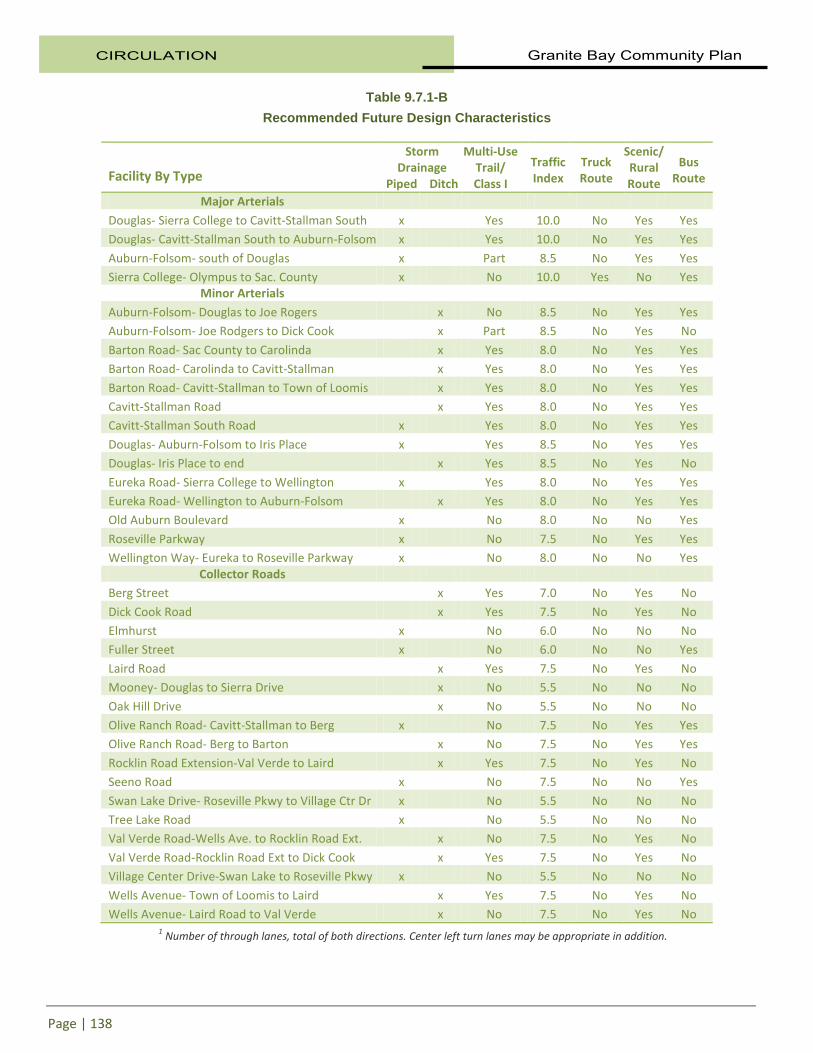
Table 9.7.1-B Recommended Future Design Characteristics
Facility By Type
Storm Drainage
Piped Ditch
Multi-Use Trail/ Class I
Traffic Index
Truck Route
Scenic/ Rural Route
Bus Route
Major Arterials
Douglas- Sierra College to Cavitt-Stallman South x Yes 10.0 No Yes Yes Douglas- Cavitt-Stallman South to Auburn-Folsom x Yes 10.0 No Yes Yes
Auburn-Folsom- south of Douglas x Part 8.5 No Yes Yes Sierra College- Olympus to Sac. County x No 10.0 Yes No Yes
Minor Arterials
Auburn-Folsom- Douglas to Joe Rogers x No 8.5 No Yes Yes Auburn-Folsom- Joe Rodgers to Dick Cook x Part 8.5 No Yes No
Barton Road- Sac County to Carolinda x Yes 8.0 No Yes Yes Barton Road- Carolinda to Cavitt-Stallman x Yes 8.0 No Yes Yes
Barton Road- Cavitt-Stallman to Town of Loomis x Yes 8.0 No Yes Yes Cavitt-Stallman Road x Yes 8.0 No Yes Yes Cavitt-Stallman South Road x Yes 8.0 No Yes Yes
Douglas- Auburn-Folsom to Iris Place x Yes 8.5 No Yes Yes Douglas- Iris Place to end x Yes 8.5 No Yes No
Eureka Road- Sierra College to Wellington x Yes 8.0 No Yes Yes Eureka Road- Wellington to Auburn-Folsom x Yes 8.0 No Yes Yes Old Auburn Boulevard x No 8.0 No No Yes
Roseville Parkway x No 7.5 No Yes Yes Wellington Way- Eureka to Roseville Parkway x No 8.0 No No Yes
Collector Roads Berg Street x Yes 7.0 No Yes No
Dick Cook Road x Yes 7.5 No Yes No Elmhurst x No 6.0 No No No Fuller Street x No 6.0 No No Yes
Laird Road x Yes 7.5 No Yes No Mooney- Douglas to Sierra Drive x No 5.5 No No No
Oak Hill Drive x No 5.5 No No No Olive Ranch Road- Cavitt-Stallman to Berg x No 7.5 No Yes Yes Olive Ranch Road- Berg to Barton x No 7.5 No Yes Yes
Rocklin Road Extension-Val Verde to Laird x Yes 7.5 No Yes No Seeno Road x No 7.5 No No Yes
Swan Lake Drive- Roseville Pkwy to Village Ctr Dr x No 5.5 No No No Tree Lake Road x No 5.5 No No No Val Verde Road-Wells Ave. to Rocklin Road Ext. x No 7.5 No Yes No
Val Verde Road-Rocklin Road Ext to Dick Cook x Yes 7.5 No Yes No Village Center Drive-Swan Lake to Roseville Pkwy x No 5.5 No No No
Wells Avenue- Town of Loomis to Laird x Yes 7.5 No Yes No Wells Avenue- Laird Road to Val Verde x No 7.5 No Yes No
1 Number of through lanes, total of both directions. Center left turn lanes may be appropriate in addition.

Granite Bay Community Plan CIRCULATION
Page | 139
9.8 Bikeways and Trails The benefits of non-motorized trails are multi-fold. Community connectivity, enhanced recreational opportunities, reduced environmental and noise pollution, local economic benefits, and improved health and quality of life are all positive outcomes that can be expected as the planned trails within the Granite Bay Community Plan are constructed. Residents of Granite Bay place high value on opportunities to walk, bike, or ride a horse, either for personal enjoyment, or simply to get from one pl ace to another. While these activities might often be regarded as recreational in nature, there are many important transportation benefits to be realized as well, particularly from walking and cycling within and between communities. Trails and bikeways within this plan are classified as follows:
• Class I Bikeway (Bike Path) provides a completely separated facility designed for the exclusive use of cycles and pedestrians with minimal crossflows by motorists. Motorized vehicles are not allowed on Class I Bike Paths. Class I bikeways should have a minimum 8 f oot width of hard surfaced pavement with 2 f oot graded shoulders on ei ther side. C lass I Bike Paths that are regional in nature should have a minimum 10 foot paved width. In some cases, a wider shoulder or separated native earth pathway would provide adjacent use for equestrians and those who prefer a native trail surface. Class I Bike Paths must be at least 5 feet from the edge of a paved roadway.
• Class II Bikeway (Bike Lane) provides a restricted right-of-way designated for the exclusive or semi-exclusive use of cycles with through travel by motor vehicles or pedestrians prohibited, but with vehicle parking and crossflows by pedestrians and motorists permitted. Class II Bike Lanes generally require a 4 foot bike lane with a 6 inch white stripe separating the roadway from the bike lane. Class II Bike Lanes are typically maintained as a part of the road system by the Department of Public Works.
• Class III Bikeway (Bike Route) provides a right-of-way designated by signs or permanent markings and s hared with pedestrians and m otorists. Roadways designated as Class III Bike Routes should have sufficient width to accommodate motorists, bicyclists, and pedestrians. O ther than a street sign, there are not special markings required for a Class III Bike Route. C lass III Bike Routes are typically maintained as a par t of the road system by the Department of Public Works.
• Multiple Use Trails are designed to support pedestrian, cycle, and eq uestrian traffic. Mot orized vehicles are not allowed on Multiple Use Trails. T hey are generally 6 feet in width but may be reduced in width to accommodate physical and easement restrictions. Depending on the stability of local soil conditions, Multiple Use Trails are constructed of native graded soil, decomposed granite (or similarly graded imported aggregate), or native soil treated with a stabilizing agent.
Figure 9.8.1: Hiking and cycling trails are located throughout Granite Bay.

CIRCULATION Granite Bay Community Plan
Page | 140
Trail Classifications Typical bikeways and trails are schematically depicted below.
Figure 9.8.2: Bike and Trail Classifications.

Granite Bay Community Plan CIRCULATION
Page | 141
This bikeways and trails section outlines a pr actical framework for the community’s goal of increasing non-motorized transportation and recreation options for all residents of Granite Bay. Bikeways and trails typically serve two different circulation purposes:
1. Bikeways may be a linked network of on-street bikeways that provide local residents and visitors to the area a commuting alternative to the automobile as well as providing a recreational opportunity for bicyclists and pedestrians.
The intent of the planned on-street bikeway system is to reduce automobile trips. They provide safe and direct routes linking residential neighborhoods, commercial districts, and public facilities and services.
2. Class I Bike Paths and Multiple Use Trails are valuable for commuting and transportation, but may also be a part of a network utilized for recreation and exercise. Trails along natural corridors, such as through parks and natural areas, are desirable routes because they provide a more scenic experience for the recreational user.
The Community Plan Trail Map (next page) depicts a long range vision for an interconnected system of hiking, riding, and cycling trails suitable for safe recreation as well as transportation and circulation. The proposed trail plan balances the need for a f unctional community network with respect for private property and the funding needed for full implementation. The vision is realized by acquiring trail segments as opportunity is presented through development and willing donors and completing missing sections of longer trails through capital projects. Rules and regulations governing the use of County trails and bikeways are contained within Chapter 12 of the Placer County Code. AB 1358, The California Complete Streets Act, requires the County to plan for a balanced, multimodal transportation network. Complete Streets are designed and operated to enable safe access for all users. Pedestrians, bicyclists, motorists, and transit riders of all ages and abilities must be able to safely move along and across a complete street. The Governor’s Office of Planning and Research (OPR) recommends that local jurisdictions view all transportation projects, new or retrofit, as opportunities to improve safety, access and mobility for all travelers and recognize pedestrian, cycle and transit modes as integral element of the transportation system. As key components of any multimodal transportation system, facilities for walking and cycling offer a wide range of benefits, including reduced traffic and congestion, reduced pollution, noise and other environmental impacts, and enhanced public safety. For the purpose of this chapter, “bikeway” means Class I Bike Paths, Class II Bike Lanes, and/or Class III Bike Routes collectively or interchangeably. A lso for the purpose of this chapter, “cyclist” means riders of non-motorized wheeled vehicles. Any exclusion to non-motorized wheeled vehicle use would be regulated within Chapter 12 of the Placer County Code.
Figure 9.8.3: Bike lane along E. Roseville Parkway.

CIRCULATION Granite Bay Community Plan
Page | 142
9.8.1 GOALS AND POLICIES
GOALS
1. Develop and implement a long-term plan for an interconnected system of hiking, riding, and cycling trails and paths suitable for safe recreation as well as transportation and circulation that meets the needs of users of all ages and abilities.
2. Establish a Class I Bike Path connection between the City of Roseville and Folsom Lake State Recreation Area (FLSRA) that would function as a c onnecting segment in the American River, Dry Creek, and Ueda Parkway Regional Loop Trail.
3. Support alternative non-motorized transportation by forming connections to and between new and existing neighborhoods, commercial centers, schools, and employment centers in accordance with the provisions of this Plan as opportunity arises through development and cooperation with willing property owners and neighboring jurisdictions.
4. Make use of opportunities for multiple use trails within the community while respecting private property ownership and funding limitations.
5. Encourage walking and cycling as a healthy, environmentally friendly and as an alternative mode of travel.
POLICIES
1. Trails and paths shall provide reasonably direct and convenient routes of travel for intended users and shall be conveniently located and shall not be unreasonably restricted.
2. Routes for trails and paths intended primarily for recreational use shall be designed and routed to enhance the recreation experience.
3. Multiple use trails shall be open t o all non motorized trail use by pedestrians, cyclists, and equestrians unless certain uses are excluded for safety or resource protection purposes. Special restrictions on trail use are contained within Chapter 12 of the Placer County Code. The local trail system shall be connected to the regional public trail system by the following considerations: a. Incorporate logical linkages to the adopted trail networks identified in adjacent
Community Plans and agency trail planning documents; b. Incorporate the Placer County Regional Bikeway Plan; c. Consider recreational trail circulation on a regional level; d. Promote consistency and unity between Community Plan trail elements in
nomenclature, graphic formatting, and points of connection; and, e. Provide common design standards where appropriate.
4. The development of privately owned and maintained feeder trails should be encouraged in lieu of public trail easements in areas that do not provide through connection to identified nodes or have limited potential to serve the community as a whole. Private trails that serve a specific neighborhood shall be maintained by a Homeowner’s Association or other appropriate organization.
5. At such time as Park Dedication Fees are updated in association with County Code Sections 15.34, 16.08.100 and 17.54.100 (D), the cost of trail acquisition and construction associated with the full implementation of the Community Plan trails network (for those portions outside of road rights-of-way) should be considered as a component of the park facility standards.
6. As lands are developed, dedication and improvement of multiple use trails and bikeways along with their corresponding easements shall be required where depicted in the Community Plan Trail Map. Construction of such trails and paths shall also be required by conditions of approval for land development projects. In situations when it is not feasible to construct isolated trail
Granite Bay Community Plan CIRCULATION
Page | 143
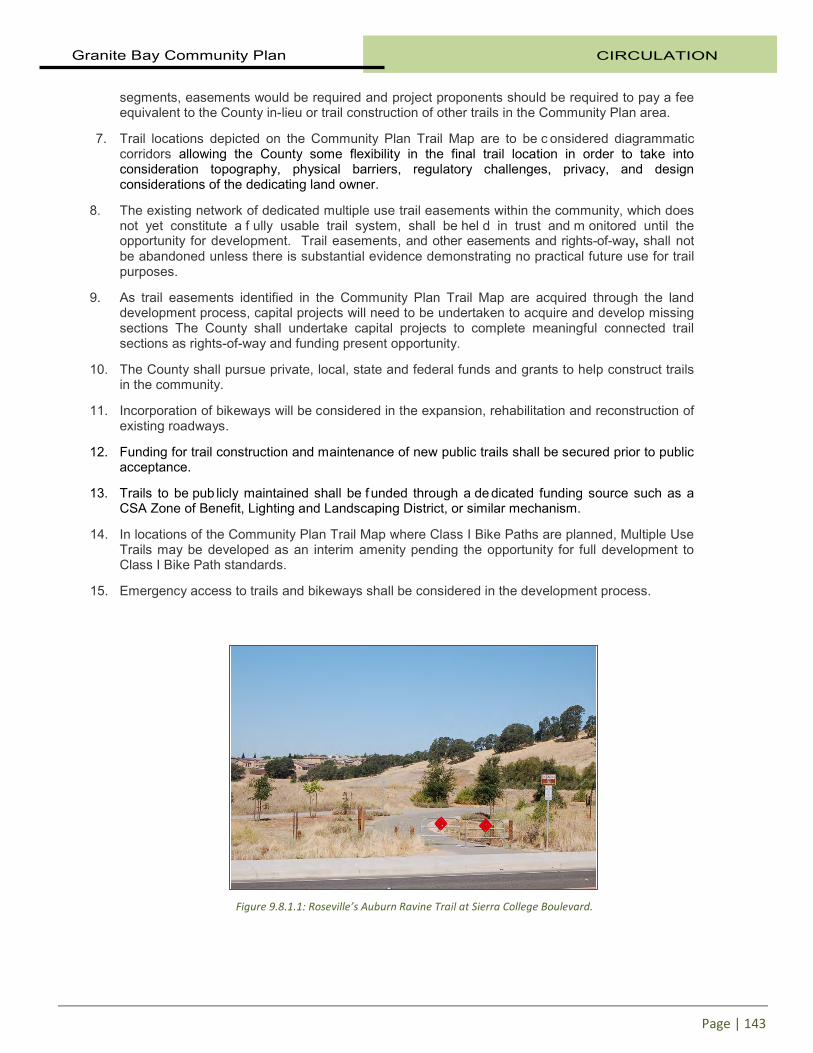
segments, easements would be required and project proponents should be required to pay a fee equivalent to the County in-lieu or trail construction of other trails in the Community Plan area.
7. Trail locations depicted on the Community Plan Trail Map are to be c onsidered diagrammatic corridors allowing the County some flexibility in the final trail location in order to take into consideration topography, physical barriers, regulatory challenges, privacy, and design considerations of the dedicating land owner.
8. The existing network of dedicated multiple use trail easements within the community, which does not yet constitute a f ully usable trail system, shall be hel d in trust and m onitored until the opportunity for development. Trail easements, and other easements and rights-of-way, shall not be abandoned unless there is substantial evidence demonstrating no practical future use for trail purposes.
9. As trail easements identified in the Community Plan Trail Map are acquired through the land development process, capital projects will need to be undertaken to acquire and develop missing sections The County shall undertake capital projects to complete meaningful connected trail sections as rights-of-way and funding present opportunity.
10. The County shall pursue private, local, state and federal funds and grants to help construct trails in the community.
11. Incorporation of bikeways will be considered in the expansion, rehabilitation and reconstruction of existing roadways.
12. Funding for trail construction and maintenance of new public trails shall be secured prior to public acceptance.
13. Trails to be pub licly maintained shall be f unded through a de dicated funding source such as a CSA Zone of Benefit, Lighting and Landscaping District, or similar mechanism.
14. In locations of the Community Plan Trail Map where Class I Bike Paths are planned, Multiple Use Trails may be developed as an interim amenity pending the opportunity for full development to Class I Bike Path standards.
15. Emergency access to trails and bikeways shall be considered in the development process.
Figure 9.8.1.1: Roseville’s Auburn Ravine Trail at Sierra College Boulevard.

CIRCULATION Granite Bay Community Plan
Page | 144
9.8.2 TRAIL PLANNING HISTORY Trail and park planning has taken place for this area in the past as part of the 1975 Loomis Basin General Plan. The 1986 Granite Bay-South Placer County Park and Recreation Plan, adopted on May 19, 1987, built on the work done at that time and addressed park planning in greater detail. The 1986 Recreation Plan was incorporated into the 1989 Granite Bay Community Plan as the Recreational Element. The 1994 Placer County General Plan establishes policies for trails in the Transportation and Circulation and the Recreational and Cultural Resources sections (sections 3 and 5, respectively). It calls for establishment of “a safe, comprehensive and integrated system of facilities for non-motorized transportation” (Transportation and Circulation Goal 3.D) and development of “a system of interconnected hiking, riding, and cycling trails and paths suitable for active recreation and transportation and circulation” (Recreational and Cultural Resources Goal 5.C). The County has established several other General Plan policies pertaining to trails including:
• Support development of a comprehensive and safe system of recreational and commuter cycle routes that provides connections between major employment and housing areas and between existing and planned bikeways;
• Integrate public trail facilities into the design of flood control facilities and other public works projects whenever feasible;
• Pursue all available sources of funding for the development and improvement of trails for non-motorized transportation;
• Work with other public agencies to coordinate the planning and development of equestrian, pedestrian, and cycling trails;
• Require the proponents of new development to dedicate rights-of-way and/or the actual construction of segments of the countywide trail system pursuant to trails plans contained in the County’s various community plans; and,
• Encourage preservation of linear open space along rail corridors and other public easements for future use as trails.
Figure 9.8.2.1: Equestrian trails crisscross the northern portion of Granite Bay.
Figure 9.8.2.2: Multiple use trails are a community priority.

Granite Bay Community Plan CIRCULATION
Page | 145
The County’s primary objectives in establishing trails are to: • Provide safe, pleasant, and convenient travel by foot, horse, or cycle; • Provide connections between residential areas, schools, community buildings, parks and other
community facilities; • Provide access to recreation areas, major waterways, and vista points; • Protect sensitive open space and natural resources; and, • Provide connections to state and city trails and regional recreational and natural resources
outside of the county for the benefit of county residents.
To meet these objectives, the County must have: • A framework of policies that serves as the basis for decision making; • Coordination within the transportation, natural resources, and recreational components of
planning documents and capital improvement plans; • Coordination among the various government and private parties involved; and, • An implementation plan addressing priorities and funding for both the near and long-term.
Related Planning Documents The Placer County Regional Bikeway Plan, prepared by the Placer County Transportation Planning Agency, provides a directory of both the existing regional bikeways and proposed improvements to regional bikeways. The primary purpose of the Regional Bikeway Plan is to provide for a r egional system of bikeways for transportation and recreation purposes. This plan places an emphasis on "regionally significant” bikeways and was adopted by the Placer County Board of Supervisors in September 2002. The proposed Dry Creek Greenway will provide a connecting corridor of walking, equestrian, and cycle trails from the Sacramento border to Dry Creek’s sources, and to the Folsom Lake State Recreation Area. The Greenway passes through several local jurisdictions, specifically the Town of Loomis, the City of Rocklin, the City of Roseville, and Placer County. The vision of the Dry Creek Greenway is for a connected open space system linking the Dry Creek Parkway with Folsom Lake State Recreation Area and the uplands of the watershed. Creation of an off-street trail system along the southern streams within the Greenway will form the final link in a s ixty to seventy mile recreational trail loop uniting the Folsom Lake State Recreation Area (FLSRA), the American River Parkway, the Ueda Parkway, the Dry Creek Parkway (DCP), and the Dry Creek Greenway. However, significant barriers stand in the way of trail development along the stream corridors including private ownership and permitting requirements inherent in riparian proximity.
Figure 9.8.2.3: The Dry Creek Greenway calls for a multiple use trail connecting Folsom Lake to Roseville and beyond.

CIRCULATION Granite Bay Community Plan
Page | 146
The Dry Creek Greenway Concept Plan (Figure 9.8.2.4 below) depicts several proposed trails along stream corridors that are not included on official Community Plan Trail Maps. In the case of these additional proposed trails, acquisition and d evelopment would only occur once a v iable segment could be identified taking into consideration ownership status, funding, connectivity to the Community Plan trail network, and physical/regulatory constraints.
Figure 9.8.2.4: Dry Creek Greenway Concept Plan

Granite Bay Community Plan CIRCULATION
Page | 147
9.8.3 EXISTING FACILITIES The trail system in Granite Bay has both a recreational and utilitarian component. Multi-use trails can provide an alternative mode of transportation. It is important to identify existing routes and facilities, as well as significant opportunities to expand on the current system. The long-range trails plan for Granite Bay provides for new or improved linkages between neighborhoods, major parks and n atural areas, points of interest, and neighboring communities. Establishing a system of trails in an existing built community is a challenge. Granite Bay was primarily developed around automobile transportation and pedestrian and bike facilities were secondary considerations. T he present popularity of cycling and walking as a mode of transportation and the emphasis on active living and other current trends were not anticipated or planned. P edestrian connectivity in Granite Bay is limited and is primarily provided with sidewalks and road shoulders. Bikeways From a regional perspective, facilities for cycling are of paramount interest due to their efficiency as a t ravel mode over short, medium, and l onger distances. Pedestrian travel, while still very important, tends to be a much more localized form of non-motorized transportation and is, for most people, a more practical option in or near urban areas where population density is higher and trip lengths are relatively short. The existing on-road system in Granite Bay consists of approximately 11.7 miles of Class II and Class III bikeways, as identified in the table below.
Table 9.8.3.1
Existing On Road Class II and Class III Bikeway Facilities in Granite Bay
Corridor Beginning Point End Point Type Miles Auburn-Folsom Road Sacramento County Douglas Boulevard Class III 2.2
Cav-Stallman So. Road Cavitt-Stallman Road Douglas Boulevard Class II 0.3
Douglas Boulevard Sierra College Blvd Auburn-Folsom Road Class II 3.0
E. Roseville Parkway Roseville City Limit Barton Road Class II 2.3
Eureka Road Rockingham East of Wellington Class II 0.6
Old Auburn Road Sierra College Blvd. Roseville Class II 0.8
Sierra College Blvd. Sacramento County Cavitt-Stallman Road Class II 2.0
Wellington Way E. Roseville Parkway Eureka Road Class II 0.5
Total 11.7
Figure 9.8.3.1: Class II bikeway along Douglas Boulevard.

CIRCULATION Granite Bay Community Plan
Page | 148
Trails The system of off-road trails in the community consists of over 40 miles of Class I and multiple-use trails. It includes trail segments in Folsom Lake State Park with connections to the American River Parkway, recognized as one of the premier, regional off-road pathway systems in the United States. It also includes connections to the famous Pioneer Express Trail that is planned to connect to Carson City, Nevada. The Placer County Parks Division has the responsibility for identifying funding methods, planning and developing multiple use and Class I trails that are separated from the roadway. The table below identifies the existing trail facilities in the community. Key segments in a community trail system are available, but these routes are incomplete or intermittent at best.
Table 9.8.3.2
Existing Multiple Use and Class I Trail Facilities in Granite Bay
Corridor or Trail Name Beginning Point End Point Type Miles
Miner’s Ravine Sierra College Blvd Cavitt-Stallman Rd. Class l 0.2
Douglas Boulevard Oak Knoll Drive Folsom State Park Class l 0.6
American River Bikeway Sacramento County Beal’s Point Class l 3.0
Treelake Parkway Roseville City Limits Treelake Park Class l 1.0
Treelake Trail Treelake Park Barton Road Multi-use 1.1
Baldwin Reservoir Trail Barton Road Beal’s Point Multi-use 1.3
Greyhawk Drive Douglas Boulevard Eureka Road Multi-use 0.3
Eureka Road Greyhawk Drive Silverwood subdiv. Multi-use 0.2
Barton Road Sacramento County E. Roseville Parkway Multi-use 1.0
Boulder Road Boulder Road Folsom State Park Multi-use 1.0
Miner’s Ravine Reserve Miner’s Ravine Park Loop and spurs Multi-use 0.5
Lomida Lane/Sterling Point Auburn-Folsom Rd. Folsom State Park Multi-use 2.5
Pioneer Express Trail Sacramento, Co. Auburn Multi-use 12.0
Folsom State Park Douglas Boulevard Loop Multi-use 10.0
Sierra College Blvd. Cavitt-Stallman Rd. Rocklin City Multi-use 3.0
Los Lagos Trail Moss Lane Folsom State Park Multi-use 3.0
Total Miles 40.7

Granite Bay Community Plan CIRCULATION
Page | 149
9.8.4 RECOMMENDATIONS The proposed bikeway and trail routes, shown on the Community Plan Trail Map, create a vision for a coordinated system of trails throughout Granite Bay and beyond. The Parks Division of the Department of Facility Services coordinates trail planning, acquisition, development, and management with appropriate jurisdictions including the cities and adjacent counties. The Department of Public Works coordinates the planning and development of bike routes and lanes within the road right-of-way including the conditioning of private development requirements and management of capital improvement projects. Primary interaction with the Placer County Transportation Planning Agency over bikeway planning is coordinated by the Department of Public Works. Long-range “connectivity” is a principal planning element for regional trails that extend beyond the borders of Placer County. The County trail system is planned to be linked to provide for regional trails including connections to the Folsom Lake State Recreation Area/American River Parkway, Auburn State Recreation Area, and the Dry Creek Parkway in Sacramento County. Bikeways The bikeway plan for the Granite Bay community was developed with consideration given to both local and adjacent communities’ needs. The local land uses that could generate cycle traffic such as schools, parks, etc. were identified, and the plan is designed to provide reasonable connectivity within the community to those facilities along with the major residential areas, employment and business centers. Additionally, the bikeway plans for the Town of Loomis, the cities of Roseville and Folsom and the Horseshoe Bar/Penryn community were considered to assure reasonable connectivity with regional facilities. A prioritized list of Class II Bike Lanes is provided in the table below.
Table 9.8.4.1
Prioritized Plan for Class II Bikeway Improvements in Granite Bay
Corridor Beginning Point End Point
Top Priority
Auburn-Folsom Road Folsom City Limit Douglas Boulevard Barton Road Sacramento County Loomis Town Limit
High Priority
Cavitt-Stallman Road Barton Road Auburn-Folsom Road American River na na Dry Creek na na Ueda Parkway na na
Lower Priority
Auburn-Folsom Road Douglas Boulevard Dick Cook Road Old Auburn Road Sierra College Boulevard Roseville Eureka Road Wellington Way Auburn-Folsom Road
Regional Connections
In terms of on-street bikeways, wide, paved shoulders which are important to safe and efficient cycling can be found along many County roads. However, shoulder conditions and widths can be highly variable, and cyclists are likely to encounter sections with narrow or non-existent shoulders along some routes. This may be

CIRCULATION Granite Bay Community Plan
Page | 150
generally acceptable on quiet back roads with low traffic volumes and good visibility, but is not desirable for key connecting routes between communities or major destinations. Trails The intent of the trails system identified in this Community Plan is to implement an interconnected system of trails and paths suitable for safe recreation as well as transportation and circulation. This is accomplished with connections between and through future development, thereby providing the feeder system for the major trails and enhancing overall connectivity of the trail system. The local trails should link to regional trails as well as to major residential areas and areas of horse populations, employment centers, park and r ecreation areas, schools, creek corridors and vista locations. To the extent allowed by law, the proponents of new development are required to dedicate easements and, where appropriate, construct those segments of the Community Plan identified trails that coincide with the parcels to be developed. In the case of smaller development projects that provide trail easements, the likelihood of near term usefulness and connectivity may be taken into consideration when determining whether trail construction would be a beneficial requirement at the time of project improvements. In cases where trail construction is not required at the time of development, the collection of an in-lieu fee should be considered. Trail easements may also be acquired by willing sellers or donors including private owners, utilities, and other agencies. As portions of longer trail segments fill in through acquisition, the County would evaluate means to fund and develop final connecting sections in order to complete meaningful connected trails. An example of this strategy is the 2010 capital project that constructed missing sections of meandering sidewalk along the north side of Douglas Boulevard. In the case of feeder trails that serve a single neighborhood or small number of users, private ownership with maintenance provided by the affected property owners should be enc ouraged as an al ternative to public ownership. Private trail easements, construction, and maintenance funding can be required during the process of new development as a condition of approval and/or a provision of CC&R’s. Private ownership and operation of trails that have limited circulation value can reduce public costs and alleviate privacy and security concerns. Although certain natural areas like streams and shorelines possess linear characteristics that would be attractive to trail development, acquiring access may be c omplicated, especially where multiple ownerships break up the corridor. Regulatory compliance can also present challenges where construction is to take place in proximity to riparian areas, wetlands, and flood plains. The alignments depicted on the Community Plan Trail Map ar e to be c onsidered diagrammatic corridors allowing some flexibility in the final trail location in order to take into consideration topography, physical barriers,
Figure 9.8.4.1: Class I trail on the north side of Douglas Boulevard.

Granite Bay Community Plan CIRCULATION
Page | 151
regulatory challenges, privacy, and design considerations of the developer. In the case of Bike Paths and multiple use trails that are not connected to roadways, final trail alignments should be required to adhere to sound trail building principles for the construction of sustainable trails that are not prone to erosion or require the excessive removal of trees and other natural features. While acquisition of trail easements in a l ong range plan is a v igilant process, so is the protection and maintenance of existing public trail easement rights. Where various trail easements are held in trust for future development when connecting segments are acquired, the presence and value of the trail easements may not be readily visible. It is therefore necessary to periodically monitor trail easements for incompatible encroachments and take corrective action. The value of a balanced long range plan for a functional network and the necessary persistence for implementation must be reinforced over time. 9.8.5 FUNDING Granite Bay Parks, Trails, and Open Space Maintenance and Recreation District The Improvement District provides funding for improvement and maintenance of specific recreational facilities currently serving approximately 8,000 parcels within the Granite Bay area. The District was established by the Board of Supervisors in 2001 following an assessment ballot proceeding in accordance with the requirements of Article XIIID of the California Constitution (“The Taxpayer’s Right to Vote on Taxes Act”) and the Landscape and Lighting Act of 1972. A more detailed discussion of the Improvement District is located in Section 10.4 “Funding” of the Recreation chapter. The Improvement District funds specific recreational amenities as outlined in the budget that is included in an Engineer’s Report updated annually. Trail development is not included in the budget. Also, bikeways within the road right-of-way are not funded by the Improvement District. Maintenance of trails is budgeted at the level of current activity on existing trails and takes into account the reliance on volunteers to perform a s ignificant proportion of necessary trail maintenance. As new parcels develop within the Improvement District, additional funds will be generated to support recreation amenities at the current service level. However, funding would not rise to a sufficient level to completely fund maintenance of the fully-implemented Community Plan trail network. County Service Area Zones of Benefit A CSA Zone of benefit should be considered as a source of supplemental maintenance funding in cases where the recreation and trail maintenance burden related to a particular development would be greater than funding provided by through annexation into the existing Improvement District. Countywide Capital Improvement Program The Placer County Department of Public Works (DPW) developed a s eparate Capital Improvement Program (CIP) within each benefit district in the county. Each CIP identifies roadway improvements needed to serve the future transportation demands on the roadway system. Projects identified in the CIP can be funded partially or wholly with fees collected through the County’s traffic fee program. The Granite Bay Benefit District includes Class II bike lanes along portions of Auburn-Folsom Road, Barton Road, Cavitt-Stallman Road, Douglas Boulevard, Eureka Road, Laird Road, and Sierra College Boulevard.

CIRCULATION Granite Bay Community Plan
Page | 152
Frontage Improvements Development projects are conditioned to fund and construct improvements for the portion of the public road on which they front. This generally requires construction of the equivalent of up to one lane and shoulder, which may include a bike lane. Concrete curb, gutter and sidewalk improvements are also required within the urban areas of the County. Park Dedication Fees (PDF’s) Park Dedication Fees (PDF) is the collective term for in-lieu recreation mitigation fees collected under two sections of state law, the Subdivision Map Act (“Quimby Fees”) and the Mitigation Fee Act (“AB1600 Fees”), and enabled by ordinance passed by the Placer County Board of Supervisors. A detailed discussion of PDF’s is located in Section 10.4 “Acquisitions” of the Recreation section. PDF’s provide funding for active and passive recreation development to sustain recreation service levels as they are impacted by new development. While trails are an eligible item for funding within active parks and o pen space/passive recreation areas, the fee amounts are not sufficient to provide funding for full implementation of the Community Plan public trail network. Grants Placer County has been successful in obtaining grant funding for acquisition and development of passive recreation facilities throughout unincorporated areas of the county. Grant programs that have served the acquisition and d evelopment of open s pace and passive recreation include
• River Parkway Grant Program (Natural Resources Agency)
• California Conservation Corps grant funded labor forces
• Riparian & Riverine Grant Program (State Parks)
• Recreational Trails Program (State Parks)
• Proposition 84 Sierra Nevada Cascade (Sierra Nevada Conservancy)
Other potential grant sources include:
• Safe Routes to Schools • Surface Transportation Program • National Recreational Trails Program • Land and Water Conservation Fund • Transportation Enhancement Grants
Figure 9.8.5.1: The Loomis Basin Horsemen’s Association maintains a number of private equestrian trails in Granite Bay.

Granite Bay Community Plan CIRCULATION
Page | 153
Additional funding sources for trails and bikeways: • Volunteers: Trail user groups provide an important component of trail maintenance by organizing
volunteer work parties for trail maintenance. Consistent volunteer service requires a level of support and coordination of the County.
• Adopt-a-Trail: Corporate, organization, and individual sponsorships of trail segments could promote a sense of ownership and help define volunteer maintenance expectations
• Use of Inmate Labor: Can be an efficient use of maintenance funds as inmate labor tends to be subsidized by the Department of Corrections. However, care must be taken to limit inmates to appropriate areas away from schools and other sensitive locations.
• Use Patterns and Deferred Maintenance: Heavily used natural surface trails incur a level of vegetation management simply by use patterns. Natural surface trails can endure deferred maintenance without extraordinary costs of rehabilitation as in the case of paved trails. Directing maintenance funding away from low-use natural surface trails may be the best candidate for savings when there is a shortfall of maintenance funding and volunteer labor.
9.8.6 IMPLEMENTATION The County shall require new development to dedicate rights of way along roadways that are wide enough to accommodate road paving, trails, paths, bike ways, drainage public utilities and substantial landscaping as appropriate.
Responsibility: Engineering and Surveying Department/Planning Division Time Frame: Ongoing Funding: Road Fund/General Fund
Review development projects for compliance with the goals, policies, and specific discussions contained in the Trails Section and throughout the Community Plan. Condition projects to provide easements and construction of trail facilities accordingly
Responsibility: Facility Services Time Frame: Ongoing Funding: Application Fees / General Fund
Require new development to annex into an existing Lighting & Landscape District and/or form of a new CSA Zone of Benefit or L&L District in order to fund improvements and maintenance associated with Trails and Bike Paths that serve the new development.
Responsibility: Facility Services Time Frame: Ongoing Funding: Development Fees / General Fund
Maintain an official Community Plan Trail Map. An official version should be adopted with each update of the Bikeways and Trails section. As actual trail easements are acquired and bikeways developed, the Trail Map should be updated to delete proposed trail corridors and replace with actual corresponding acquired easements and alignments. A copy of the official Community Plan Trail Map (electronic and/or hard copy) shall be dated and kept by the Community Development Resource Agency for public access.
Responsibility: Facility Services / CDRA Time Frame: Ongoing as easements and bikeways are acquired, as funds and
staffing permit Funding: General Fund

CIRCULATION Granite Bay Community Plan
Page | 154
Prepare for adoption by the Board of Supervisors and inclusion in the Placer County Code, enforceable regulations for orderly, safe use of trails and bikeways.
Responsibility: Public Works / Facility Services / Parks Commission Time Frame: Periodically as needed Funding: General Fund
Undertake capital projects to acquire and develop missing segments of trails when not available through land development requirements in order to form meaningful extended trail sections consistent with the Community Plan identified trail network
Responsibility: Facility Services / Public Works Time Frame: As rights-of-way and available funding present opportunities Funding: Fees / Grants / Other to be Determined
Periodically review trail acquisition policy against the broader legal setting governing land development, exactions, and trails in general in order to ensure consistency with state and federal law.
Responsibility: Facility Services / County Counsel Time Frame: Ongoing Funding: General Fund
Figure 9.8.6.1: Class I trail (left) and Class II bike lane (center) on the south side of Douglas Boulevard.