climate change adaptation using on-farm …...climate change adaptation and on-farm drainage...
TRANSCRIPT
Climate Change Adaptation and On-Farm Drainage Management in Delta, British Columbia: Current Knowledge and Practices Final Report for the Delta Farmers’ Institute, Drainage and Sub-irrigation in Delta, British Columbia Project

Climate Change Adaptation and On-Farm Drainage Management in Delta, British Columbia: Current Knowledge and Practices
Final Report for the Delta Farmers’ Institute, Drainage and Sub-irrigation in Delta, Brit-ish Columbia Project
Prepared by: 1.Bryanna Thiel, 1.Gladys Oka, 1.Michelle Radley and 1.Sean M. Smukler
Advisory Committee: 2.Emily MacNair, 2.Samantha Charlton, 3.Geoff Hughes-Games, 4.Leisa Yee, 4.Da-vid Ryall, 5.Jack Bates, 5.Brent Harris, and 5.Jerry Keulen
1.University of British Columbia2.British Columbia Agriculture & Food Climate Action Initiative3.British Columbia Ministry of Agriculture4.Delta Farmers’ Institute5.Delta farmers and Delta Farmer’s Institute members
Report funded by: Growing Forward 2, a federal-provincial-territorial initiative
Acknowledgements: This report was initiated by the BC Agriculture & Food Climate Action Initiative to address drainage and sub-irrigation issues identified through the Climate Change Risk & Opportunity Assessment, and the BC Agriculture & Climate Change Delta Adaptation Strategies series (available at http://www.bcagclimateaction.ca/wp/wp-content/media/RegionalStrategies-Delta.pdf).
Thank you to the Delta Farmers’ Institute for facilitating the participation of agricultural producers. A special thank you to the 17 agricultural producers who volunteered their time to participate in lengthy interviews and share their experiences, expertise, and perceptions.
Thank you to the project Advisory Committee members in Delta who participated in Committee meetings and helped to develop the agricultural producer interviews. The project could not have been successfully completed without their valuable insights, assistance and input throughout the process.

Published: April 14, 2015
Project contact: Sean Smukler [email protected]
Opinions expressed in this document are those of the authors and not necessarily reflect those of Agriculture and Agri-Food Canada and the BC Ministry of Agriculture. The Government of Canada, the BC Ministry of Agriculture, and its directors, agents, employees, or contractors will not be liable for any claims, damages, or losses of any kind whatsoever arising out of the use of, or reliance upon, this information.

Table of Contents List of Figures ....................................................................................................................... 6
List of Tables ........................................................................................................................ 8
List of Abbreviations ............................................................................................................. 9
Executive Summary ............................................................................................................ 10
Introduction ......................................................................................................................... 12
Methods .............................................................................................................................. 14
Literature Review ............................................................................................................ 14
Farmer Interviews ........................................................................................................... 15
Mapping .......................................................................................................................... 16
Data Analysis .................................................................................................................. 17
Introduction to Delta Conditions .......................................................................................... 18
Introduction to Types of On-Farm Drainage Systems ..................................................... 21
Less Permanent Systems ............................................................................................ 21
More Permanent Systems ........................................................................................... 22
Drainage and Irrigation System Considerations ........................................................... 24
Drainage and Subirrigation Research: Delta, BC ................................................................ 27
Water table control ...................................................................................................... 27
Soil structure and drainage .......................................................................................... 31
Interview Results ................................................................................................................ 34
Demographic Information ................................................................................................ 34
Farm Information ............................................................................................................. 35
Drainage and Salinity Problems ...................................................................................... 37
On-Farm Drainage Systems ............................................................................................ 39
On-farm Drainage System Alterations ............................................................................. 43
Climate Change Perceptions ........................................................................................... 45
Research Priorities Identified by Farmers ....................................................................... 45
Discussion .......................................................................................................................... 48
Conclusions and Options for Action .................................................................................... 52
References ......................................................................................................................... 53
Appendix ............................................................................................................................ 60
A. Delta Drainage and Sub-Irrigation Project | Producer Interview Guide .................. 60

B. Adaptation to Climate Change in Delta BC: Interview Consent Form .................... 62
C. DF&WT Delta, BC Field Maps Used for Interviews ............................................... 64
D. Summary of Quantitative and Qualitative Data Analysis ....................................... 70
E. Drainage and Subirrigation Research: Other regions ............................................ 71
Canada ........................................................................................................................ 71
The United States ........................................................................................................ 72
Europe ......................................................................................................................... 73

List of Figures
Figure 1. Map of the study area in Delta BC, illustrating the five sub-regions of interest .... 16
Figure 2. Average and maximum monthly rainfall (mm) at the Vancouver International Airport ................................................................................................................................. 19
Figure 3. Shallow surface drain dug in (a) random, (b) herringbone, and (c) parallel drainage arrangements. Source: (Gartley et al. 1986) ........................................................ 21
Figure 4. Mole drains schematic and equipment details. Source: (Gartley et al. 1986) ..... 22
Figure 5. Open itch design recommendations for different soil textures. Source: (Gartley et al. 1986) ............................................................................................................................. 22
Figure 6. Field contours can be (from left to right) sloped, crowned, or dead level. The solid lines represent rainwater and the dotted lines represent runoff/drainage water. Source: (Delta Farmland & Wildlife Trust, 2014) .............................................................................. 23
Figure 7. Controlled systems showing a) controlled drainage and b) controlled subirrigation from a ditch. Source: (Lalonde & Hughes-Games 1997b).................................................. 25
Figure 8. Singular drainage systems in comparison to composite drainage systems. Singular systems consist of buried pipe laterals, and open collector drains. In composite systems, both the laterals and the collector drains are buried. Source: (Smedema et al. 2004) .................................................................................................................................. 26
Figure 9. Sustainable soil management cycle of adequate drainage and improved soil tilth showing impact of field management practise (ie subsoiling or covercropping) on the workability, trafficability, and opportunity days for farming. Source: (Lalonde & Hughes-Games 1997c) .................................................................................................................... 27
Figure 10. Boundary Bay Water Control Project experimental design. Source: (Chieng et al. 1987) .................................................................................................................................. 29
Figure 11. Relationship between the number of consecutive workable days and their probability of occurrence in March for a fine textured soil. Source (Prasher et al. 1985) ..... 30
Figure 12. Experimental sites of the UBC and Delta Farmers’ Soil and Water Conservation
Groups. Source: (Bomke et al. 1996).................................................................................. 32
Figure 13. Reclamation site experimental layout. Source: (Bomke et al. 1992) ................. 34
Figure 14. Division of farms operated by different numbers of a) primary operators and b) secondary operators. Primary operators make operational decisions for the agricultural

operation, while secondary operators participate in managerial discussions, but do not have the authority to make the final decision on an issue. ........................................................... 35
Figure 15. Total farm area captured in each sub-region through participant interviews as reported by participants on field maps. ............................................................................... 36
Figure 16. Percent of farmers (n=17) that a) report drainage problems and b) report salinity issues. ................................................................................................................................ 37
Figure 17. Occurrence of drainage problems a) reported by farmers (n=17) and b) soil clay content in Delta, BC. For each region, drainage problems are reported out of the number of farmers interviewed that farm fields in that region. .............................................................. 38
Figure 18. Occurrence of salinity on farmland a) reported by farmers (n=17) and b) digital soil survey map (as reported by electrical conductivity). For each region, salinity problems are reported out of the number of farmers interviewed that farm fields in that region.......... 39
Figure 19. Less permanent measures that were practiced in the past or are currently practiced by farmers (n=17). A past measure is one that a farmer no longer uses in their farming operation but has used at an earlier time in their practice. A current measure is one that the farmer uses for regular operations today. .............................................................. 40
Figure 20. More permanent measures that were practiced in the past or are currently practiced by farmers (n=17). A past measure is one that a farmer no longer uses in their farming operation but has used at an earlier time in their practice. A current measure is one that the farmer uses for regular operations today. .............................................................. 42
Figure 21. Reasons farmers (n=16) provided for cover cropping. ...................................... 43
Figure 22. Drainage alterations farmers (n=17) reported making to better respond to weather conditions. ............................................................................................................. 44
Figure 23. Percent of farmers (n=17) who a) responded they would make changes in the future to their on-farm drainage system, and b) of those who responded ‘Yes’ or ‘Maybe’
(59%), what activities they were considering for implementation. ....................................... 44
Figure 24. Future areas of research identified as priorities by farmers. .............................. 46
Figure 25. Percentage (a) of farmers who receive or have received monetary support for various farm management activities, and (b) from which organization they receive support. ........................................................................................................................................... 48

List of Tables Table 1. Opportunity Days (1 March to 31 May) and crop Yields (tonnes per hectare) for four drainage regimes at the boundary bay experimental site. Yields are fresh weight unless indicated by * which are dry matter yields. Adapted from (Chieng et al. 1987) ................... 30
Table 2. Monthly average a) volumetric water content (m3 water m-3 soil) and b) soil moisture potential (cm) in the bare (control), spring barley, and winter wheat plots at the Nottingham site (1991-92). Four replicates were used per plot and depth. Adapted from Bomke et al. 1996. .............................................................................................................. 33
Table 3. Time of year farmers (n=17) reported their water table being highest, and having salinity issues. .................................................................................................................... 37

List of Abbreviations Delta – The District Municipality of Delta
DFI – Delta Farmers’ Institute
DF&WT – Delta Farmland and Wildlife Trust
FFD – frost free days
GDD – growing degree days
GIS – geographic information systems
GPS – global positioning system
UBC – University of British Columbia
UBC B-REB – University of British Columbia Behavioural Research Ethics Board
US - United States
YVR – Vancouver International Airport

Executive Summary The lower Fraser River delta of British Columbia is one of the most productive regions in the province, yet farmers in this area are challenged with conditions of poor drainage and soil salinization that adversely impact their operations. Climate change projections predict increased intensity of rainfall and variability in weather patterns, making the need for improved drainage conditions necessary to maintain and improve the production capability of the area in the future. To better understand the state of existing knowledge and the potential needs for further drainage and subirrigation work on farmland in Delta, a team of researchers from the University of British Columbia were contracted by the Delta Farmers’
Institute to: 1) compile a comprehensive review of past drainage and sub-irrigation studies in Delta; 2) review drainage and sub-irrigation research from other regions that could provide insight for alternative management options in Delta; and 3) assess how farmers across production and soil types in Delta are currently coping with drainage related problems to gauge the need and interest for further research.
An extensive literature review was conducted to document the information that has already been generated on these issues. Grey literature, including provincial and national reports, and scientific literature, focused on, but not limited to Delta, was reviewed. All literature (276 documents) was categorized in a centralized and open source portable document format (PDF) organization system (www.mendeley.com) now publicly available.
The literature review revealed that substantial research has been conducted in the Delta region since the 1980s; topics include water table management, sustainable soil management through cover cropping, and soil reclamation. Challenges of drainage and salinity in agriculture are also faced in other regions in Canada, the United States, and Europe. Literature from these regions was reviewed to identify additional resources to assist farmers in making informed on-farm management decisions.
In-person interviews were conducted with vegetable, berry, and forage farmers throughout Delta, to evaluate management practices currently employed, and perceptions on their effectiveness; areas within Delta continuing to have drainage and salinity problems; and areas of research farmers felt were valuable for, moving forward to alleviate drainage and salinity problems.
Interviews revealed that 76% of farmers currently experience drainage and/or soil salinity problems. Less permanent measures that are used to drain fields include mole drains, shallow surface drains, and subsoiling, while more permanent measures include drainage tiles, laser levelling, and open ditches. It was evident from the interviews that the farming community in Delta is very diverse, with different seasonal water management needs, farming experience, and resources, illustrating the improbability of developing a “catch-all”
drainage solution for the region.
It is clear from the interviews that a knowledge gap exists between the research that has already been conducted and farmers’ current understanding of solutions. Furthermore, our
results indicate that the body of research on drainage in Delta has been, and continues to be, difficult to access and not well used.
Findings from this study suggest that farmers are using a number of drainage and soil salinity management systems, but remain unclear about how best to address persisting problems. The variability in landscape, land use, farmer experience, and farmer management approaches throughout Delta suggest different solutions will be appropriate for different farmers. Findings from the literature, while useful, may be outdated in terms of costs and current landscape conditions, presenting a need to update this information to best serve Delta farmers in the future. Finally, incentives would likely assist with adoption of appropriate drainage and soil salinity management practices in the context of short-term land tenure.

12 Climate Change Adaptation Using On-Farm Drainage Management in Delta
Introduction The District Municipality of Delta (Delta), located within the delta of the lower Fraser River, is a substantial agricultural producer in the province of British Columbia (BC). In 2010, farm receipts in Delta totaled $170 million (CAD), and the region accounted for 50% of potato, 50% of greenhouse vegetable, and 25% of field vegetable provincial production by area (Metro Vancouver 2012). Although extremely productive, most soils in Delta are fine textured and do not drain well (Luttmerding 1981). Drainage problems are exacerbated by a high water table, low land elevation (0 to 3 meters above sea level), and an average annual rainfall of 930 mm that comes mainly during the winter months (Environment Canada, 2014). These conditions make appropriate drainage critical for agricultural production. Drainage problems can reduce the number of days famers can access their fields, result in yield reducing salt build up in soils, cause losses of soils through erosion and, in extreme weather conditions, result in total crop losses due to flooding. There have also been shifting climatic conditions in this region that have made these problems worse including major floods that resulted in substantial crop loss and inability to harvest, such as the unseasonal rains in the late summer of 2010 (Temple et al. 2011). Climate models for the region that there will be changes in conditions that will result in increased difficulties with drainage.
Climate projections for Delta indicate that changes in temperature and precipitation could result in both positive and negative outcomes for agriculture. Temperatures are expected to increase 1˚C by the 2020s and 1.7˚C by the 2050s (B.C. Agriculture & Food Climate Action Initiative 2013a). It is also expected that by the 2020s Delta will have 14 more frost free days (FFD) and 224 more growing degree days (GGD) annually and substantially more by the 2050s (22 FFD and 415 GGD). These types of temperature shifts could mean increased agricultural productivity. However, the predictions for precipitation are likely to result in increased drainage problems. Overall, precipitation patterns are expected to continue to shift and increase slightly, resulting in drier summers and wetter winters. An overall 4% annual increase in precipitation is anticipated by the 2020s, and 7% by the 2050s (B.C. Agriculture & Food Climate Action Initiative 2013a). Probably most important for Delta’s
agricultural production is the predicted increased magnitude, frequency, and intensity of extreme rainfall events .
Changes in precipitation patterns will impact the hydrology in a number of ways. Most important, would be if the intensity of rainfall increases, (i.e. increased amount over a short duration of time), flooding events would be likely as soil infiltration capacity or drainage infrastructure is overwhelmed. If these events occur when crops are still in the ground it will likely result in the loss of those crops. Although annual watershed runoff is predicted to increase, spring runoff is expected to occur earlier resulting in decreased flows in the summer when irrigation is in demand. Long-term projections suggest climate change impacts combined with land subsidence could result in a net sea level rise between 0.35 and 1.2 m (1.1 to 3.9 ft) by 2100 (B.C. Agriculture & Food Climate Action Initiative 2013a). This will force salt water farther up the Fraser River, and potentially raise Delta’s water

Climate Change Adaptation Using On-Farm Drainage Management in Delta 13
table, which could lead to increased surface soil salinity. Together these changes are likely to have impacts on agriculture including: limited water supply during late summer and fall; increased demand for irrigation water; inability to pump water at high tide out of the system; increased pressure on drainage and water management; and increased salinization of soils and a time lag for recovery (B.C. Agriculture & Food Climate Action Initiative 2013a).
Farmers in Delta have recognized for some time that drainage is an important problem, but it is unclear if current drainage management strategies are adequate for recent changes let alone future changes in precipitation. Farmers have long used a variety of drainage practices on their farmland throughout Delta which vary in infrastructure and financial investment, maintenance effort and durability. These include less permanent measures such as surface drains, mole drains, and subsoiling, or more permanent measures such as laser levelling, private ditches, and tile drains. Additionally, a network of ditches, sloughs, dykes, flood gates, and pumps support these on-farm measures and are managed by the Corporation of Delta.
The drainage practices that have been employed have been developed from a substantial body of scientific research, some of which was done in Delta starting in the 1980s. Field experiments were conducted in Delta to determine: the impact of subsurface drainage and subirrigation on crop yields (Chieng et al. 1987); the effect of controlling the water table on field workability and trafficability (Driehuyzen 1985); the use of cover crops for sustainable soil management to build soil structure (Bomke et al. 1996; Liu et al. 2005; Hermawan 1995); and the impact of altering tillage practices on soil structure (Krzic et al. 2000). Much of this work has been compiled into a few key drainage related documents such as the B.C. Agricultural Drainage Manual (Lalonde & Hughes-Games 1997a), and Factsheets produced by the BC Ministry of Agriculture on Drainage, Constructed Ditch, and Riparian Management (http://www.agf.gov.bc.ca/resmgmt/publist/Water.htm).
While there have been a number of studies of on-farm drainage management in Delta, there are concerns about the current utility of this work (Zbeetnoff Agro-Environmental Consulting & Quadra Planning Consultants Inc. 2011). The primary concern is that despite substantial efforts to better understand drainage management problems and develop materials for farmers to utilize this information, on-farm drainage problems seem to be increasing and could increase even further as climate patterns shift. It may be that the research that has been done to date was done in the context of past climatic conditions, farm management (e.g., different crops and technologies), or economic conditions (e.g., infrastructure installation costs have changed since the 1980s). Another concern is that the information that farmers need to make drainage management decisions may not be perceived as readily available or in a useful format.
To begin to address some of the contemporary concerns, and to better understand the need for further drainage and subirrigation work on farmland in Delta, a team of researchers from the University of British Columbia were contracted by the Delta Farmers’ Institute for the

14 Climate Change Adaptation Using On-Farm Drainage Management in Delta
current study. The researchers were supported by an Advisory Committee, which included representation from the BC Ministry of Agriculture, the BC Agriculture and Food Climate Action Initiative, Delta Farmers Institute (DFI), and a number of producers from the region. The primary objectives of this study were to: 1) compile a comprehensive review of past drainage and sub-irrigation studies in Delta; 2) review drainage and sub-irrigation research from other regions that could provide insight for alternative management options in Delta; and 3) assess how farmers across production and soil types in Delta are currently coping with drainage related problems to gauge the need and interest for further research.
To achieve objectives 1 and 2 we reviewed information provided by provincial and national reports, scientific literature, and grey literature and compiled these into an online bibliography that is freely available. For objective 3 we conducted in-person semi-structured interviews with farmers targeting conventional and specialty (certified organic) vegetable, forage, and berry producers in a sampling effort that was stratified across Delta to capture variation in crops, soil and climate. Through these interviews we were specifically trying to answer the following overarching questions: 1) What drainage system configurations respond best under the most common weather, soil, and cropping conditions in Delta?; 2) Are farmers currently making changes to their drainage systems to address climate change impacts, specifically the increased likelihood of flooding and salinization? and, What are these changes?; and 3) What information would help make on-farm drainage management decisions more feasible in the context of the predicted outcomes of climate change in Delta? In this report we present details of our methodology, the findings of this literature review and farmer survey, and provide a set of recommendations for future work.
Methods
Literature Review We reviewed grey literature, including provincial and national reports, and scientific literature focused but not limited to Delta in order to: identify current management practices used for on-farm drainage management by farmers; determine anticipated climate change effects in the 20, 50 and 100 year timeframe and how these may impact drainage management; and identify potential barriers or opportunities other studies have identified for farmers to adopt alternative drainage technologies. The review also included literature on alternative drainage technologies from areas with comparable conditions including: low elevation, fine textured soils, temperate climates, high levels of precipitation, and similar cropping systems (Appendix F).
Specific categories of interest were identified and systematically targeted (i.e. used as search terms) to prepare a comprehensive bibliography of all available research carried out to date on the topic of on-farm drainage, flood risk, and salinity management in Delta, BC. Reports unavailable in electronic format were scanned and made available electronically.

Climate Change Adaptation Using On-Farm Drainage Management in Delta 15
Literature were imported, tagged, and organized in a free reference and PDF organization software, Mendeley (http://www.mendeley.com/). This literature is publicly accessible under the “Delta, BC Drainage and Sub-irrigation” reference group which currently contains 276 documents.
Farmer Interviews We used three categories from the most recent census data, collected in 2011 (Metro Vancouver 2012), number of farms (202), size of farms (average of 35 ha/86 ac), and number of operators (280) to determine an optimal and representative number of participants to be interviewed in Delta. Our priority was to capture a large percentage of the farmed area in Delta and the variability across the region. The Advisory Committee identified three producer types and delineated five sub-regions of Delta that they thought would stratify the region by variations in soil and climate. A sample size of 15 farmers was targeted to represent at least 20% of the farmland (by area) in the region. Interviewees were recruited primarily through the DFI and as a result not, all Delta farmers had an equal chance of being selected for participation. During the selection process a preference was also given to interviewing farmers that operate on larger areas of land to maximize our understanding of how most of the region is being managed.
The semi-structured interviews were conducted taking into account the age, ancestry, farm size, farm location, and production type of farmers and farms (Posthumus et al. 2008). Semi-structured interviews were used because this method allows for the collection of targeted information, and also for new ideas to be brought up to respond to what the interviewee finds meaningful about the topic being discussed (Stringer et al. 2006). We used an interview guide of 44 questions that was divided into three distinct areas of inquiry (see Appendix A for full list of questions). Participants were recruited in one of three ways: by an email sent out on October 30, 2014 to all DFI members, by sign-up sheet after a presentation of the project at a DFI meeting November 5, 2014, or by snow-ball sampling (Posthumus et al. 2008) from participants.
In-person interviews were conducted between November 1, 2014 and January 10, 2015. Participation was entirely voluntary and prior to conducting the interview, participants were briefed on the purpose of the research, questions they would be asked, dissemination of the findings, maintenance of privacy and anonymity, and their right to decline participation at any time. Participants signed an informed consent form acknowledging their rights in the research process (see Appendix B).
During the approximately 90 minute interview, participants were asked to share information about how they manage their drainage on-farm, what issues they have faced in the past, what solutions they believe are viable in the future, and what information would be valuable to them for making drainage management decisions in the future. When asked about drainage and salinity problems farmers were instructed to use their own definition of “problem” as it applied to their operation; this means what was considered a problem for

16 Climate Change Adaptation Using On-Farm Drainage Management in Delta
one farmer may not be considered a problem for another. Demographic and farm information were also collected to help categorize responses from participants. There were no anticipated risks or direct benefits to participants.
The interviews were audio-recorded to help with analysis. All data were encrypted and kept on a password protected hard-drive. If participants desired to have any of their personal information shared, they were able to indicate this on the informed consent form. Otherwise all interview responses were aggregated and are not traceable back to the individual participant.
These methods were rigorously reviewed by the University of British Columbia Behavioural Research Ethics Board (B-REB) and an Approval Certificate was issued on October 29, 2014 (project ID H14-02412). Only approved UBC B-REB researchers had access to any identifying participant information throughout the study, and following completion of the study, data will be kept for at least 5 years in an encrypted and password protected format in a secure location at UBC.
Mapping The Lowland areas of the Municipality of Delta were divided into five sub-regions of interest: Westham Island, Crescent Slough, Ladner South/Brunswick Point, Ladner East/Boundary Bay Airport, and East Delta (Figure 1). During the interview, participants were asked to identify the fields they farmed on a series of hard-copy maps (see Appendix C) originally developed by Agriculture and Agri-Food Canada in 2000. The information that was requested included identifying which fields were rented or owned, and which fields experienced the most extreme drainage and salinity problems.
Figure 1. Map of the study area in Delta BC, illustrating the five sub-regions of interest

Climate Change Adaptation Using On-Farm Drainage Management in Delta 17
The information recorded on the hard-copy maps during the interviews was then transferred to a geographical information system (GIS) and satellite imagery in ArcGIS 10.2 (ESRI 2015). Visual estimation was used to identify the individual fields from the hard-copy maps on the satellite images, based on their relative size, shape, and proximity to streets. Using this information, it was possible to determine the geographical reach of the interviews. The total area captured in each region as described by participants on field maps deviated from the total area reported verbally by participants by approximately 5%. Reasons for the deviation include: 1) area changes in farmed land from year to year because of changing leases, 2) omissions of certain areas on the map (a possible source of error since the area reported by map was lower than the area reported verbally by farmers), and 3) uncertainty in the area estimations through conversions of hard-copy maps to an electronic format. Once the fields were located on the satellite imagery, shapefiles for information that the farmers had provided were created. The same process of visual estimation was used to identify the total potential farmable area. Any area greater than 1 acre (0.4 ha) in size that appeared undeveloped and lacking in infrastructure, and was in close proximity to other known fields or agricultural areas was considered to be potential farmland. In order to estimate how many hectares of the total Delta farmland were assessed through this study, an additional shapefile was created within each of the five sub-regions to represent the total farmable area. The field area reported in the study was then reported as a percent of the total farmable area.
We used the British Columbia Detailed Soil Survey data (Agriculture and Agri-Food Canada, 2010), to assess the biophysical similarities and differences within and across the five sub-regions. Maps of clay content, sand content, and organic matter across Delta were compared to the spatial distribution of survey responses.
Data Analysis Based on the information collected using the interview guide, we organized the farmer responses into the following categories: demographics, drainage and salinity issues, drainage and irrigation systems, response of drainage system to weather, and information for future drainage decisions. Responses were recorded using field notes during the interview. After the interview, responses were categorized into a response grid for each participant. The audio-recordings were then listened to in their entirety by a second reviewer and responses were confirmed or amended as needed. Once the response grid was complete, data were analyzed either quantitatively or qualitatively based on the nature of the question (Appendix D). Quantitative assessment was completed when responses could be categorized while maintaining the depth of information the participant wished to convey. When this was not possible, a qualitative, descriptive summary was generated.

18 Climate Change Adaptation Using On-Farm Drainage Management in Delta
Introduction to Delta Conditions
The soils and topography in the study area are fairly typical of those found in deltaic regions. The soils are formed in sediments deposited by the Fraser River as it reaches the Straight of Georgia. According to the Canadian System of Soil Classification, 6 soil series make up 92% of the land area in Delta, 56% of which are Humic Gleysols in saline phase, and 36% are not in saline phase (Luttmerding 1981). This region is slightly undulating with 1-3% slopes and elevations 1 to 3 m above sea level. Soil textures can be classified as silt loam to silty clay loam at the surface transitioning to sand and loamy sand in the subsoil. These types of soils have a high water holding capacity and poor drainage. During the winter, water tables are close to the surface, but recede in the summer. The cultivated top 20 cm of soil are friable to firm with a weighted average organic matter content of 6% for the dominant mineral soils. In the deeper layers of the soil profile, salinity and massive textures can restrict crop rooting. These soils are also characterized by high to very high nutrient holding capacity, and pH is generally acidic throughout the profile.
Delta’s maritime climate is characterized by relatively warm, rainy winters, and relatively cool, dry summers (Luttmerding & Sprout 1969). July and August are the driest months of the year but also the warmest and most productive, therefore requiring the greatest amount of irrigation. Conversely, 75% of the annual precipitation occurs between October and March, making drainage most important during these months (Dakin 2014). The average annual temperature and precipitation measured at the Delta Tsawwassen Beach station for the period of 1981-2010 is 11˚C and 930 mm, respectively (Environment Canada, 2014). Long-term climate monitoring at the nearby Vancouver International Airport (YVR) illustrates shifting climate patterns. YVR climate data shows rainfall between 1993-2012, both monthly average and maximums, occurring later in the spring compared historic (1953-1992) records.

Climate Change Adaptation Using On-Farm Drainage Management in Delta 19
Figure 2. Average and maximum monthly rainfall (mm) at the Vancouver International Airport
In Delta, 80% of the area in the Agricultural Land Reserve (ALR) is used for agriculture (B.C. Agriculture & Food Climate Action Initiative 2013a). According to the 2011 Statistics Canada census (Metro Vancouver 2012), land in agricultural production in Delta totalled nearly 7,000 ha (17,300 acres) and was comprised of 202 farms at the time. A farm is defined in both the census and current study as an agricultural operation that is managed by the same agricultural operator(s) (Statistics Canada, 2015); the geographic reach of the land managed does not need to be continuous. The total land farmed in Delta in 2011 had decreased by 532 ha (1,339 ac) since the previous five years, and the average size of a farm was 35 ha (86 ac). The distribution of farm size was skewed towards midsize farms in the range of 4 to 28 ha (10 to 69 ac) for 91 farms. Only 9 farms were over 162 ha (400 ac), and 47 were under 4 ha (10 ac). Over half of the farms were owned (51%), while 8% were leased from the government, and 39% were rented or leased from other providers (Metro Vancouver 2012). A trend of aging farm operators was evident in 2011; 320 farm operators were present, and had a median age of 54.5 yrs. Of the crop production farms that were present, 103 produced hay and field crops; 45 vegetables; 55 fruit, nuts and berries; 12 nursery products; 23 greenhouse products; and 23 potatoes (Metro Vancouver 2012).
Delta is managed by an extensive dyke system to protect against crest elevations of 3.2 to 4 m (Hemmera 2012). The South Delta Watershed is 13,500 ha (33,359 ac) in area (Hemmera 2012). From fall to spring, “drainage mode” is induced where water is collected through a network of drainage ditches and released into the Fraser River, Strait of Georgia, and Boundary Bay through 21 outfalls. During this time, water levels are kept low as much as possible. In Delta, the drainage system is comprised of a 360 km network of constructed ditches, 73 km of closed conduit storm drains (mainly in urban areas), and three major and
0.0
50.0
100.0
150.0
200.0
250.0
300.0
350.0
400.0
Jan Feb Mar Apr May Jun Jul Aug Sep Oct Nov Dec
Pre
cip
ita
tio
n (
mm
)
Month
1953-1992 average
1993-2012 average
1953-1992 maximum
1993-2012 maximum

20 Climate Change Adaptation Using On-Farm Drainage Management in Delta
two secondary outfalls. Of this 360 km network system, the Corporation of Delta manages 127 km, while farmers, private entities, and operators of transportation corridors manage the rest. The major outfalls are Chillukthan Slough, Mason Canal, and Brandrith—these are comprised of flood boxes and pump stations which allow for gravity outflow when the tide is low and pumping of water out when the tide is high (Hemmera 2012). Approximately 25% is discharged by gravity, and the rest by pumping. The three major outfalls are responsible for 94% of discharge, while the secondary outfalls only account for 6%. The Chillukthan Slough water level control structure limits the maximum water level rise in the Ladner section by managing the northbound runoff flows originating from farmland in the south (Opus International Consultants, 2014). Agricultural drainage is detained and diverted to the south. This system incorporates sluice gates that allow for irrigation flows to move south during the summer when there is little flood risk and a high demand for irrigation water.
The irrigation and drainage system(s) in Delta are closely linked. Despite plentiful annual rainfall, irrigation is needed to supplement the limited rainfall occurring during July and August, and to reduce salinity in soil. The irrigation system in Delta is made up of gravity water intakes at multiple locations along a 15 km (9 mi) stretch of Lower Fraser River (GMV Engineering, 2012). Diurnal tides can influence water levels 120 km (75 mi) upriver, with a salt wedge penetrating 22 km (14 mi) upstream to the City of New Westminster during low flow in the winter. The tidal influence on the availability of water is related to the tide height and salinity of the Fraser River (GMV Engineering, 2012). Water is mainly distributed by gravity and two lift stations across 3,000 ha (7,413 ac) to approximately 50% of the total agricultural acreage. In the future, it is estimated irrigation needs will increase to 75% of total area (GMV Engineering, 2012). Water with low levels of salinity is available in spring and early summer when the Fraser River flows are high (Hemmera 2012). From late summer to fall, flows in the Fraser River are low and salinity levels are high; thus irrigation is dependent on water stored in ditches.
In 2012, to address and sustain Delta’s future agricultural water needs, the Delta Irrigation Enhancement program (DIEP) was developed to improve on the quality of supplied water and the reliability of this water supply (GMV Engineering, 2012). This program involves a new irrigation water intake at 80th Street, Delta, BC. Upon completion, there will be a 32 km (20 mi) long delivery route which will include 8 km (5 mi) of new irrigation channels and 3 km (2 mi) of closed conduits. The 80th Street Pump Station is reversible; this allows for intake during the irrigation season and discharge during the drainage season. The pump is instrumented with salinity sensors which can detect when Fraser River salinity exceeds the pre-set threshold and stop the pump, resuming when salinity falls below the threshold. A demand controlled system will be used which will arrest delivery once irrigation is stopped or water is supplied by storm events.

Climate Change Adaptation Using On-Farm Drainage Management in Delta 21
Introduction to Types of On-Farm Drainage Systems Here we categorized drainage systems primarily as either less permanent, or more permanent management types. Each has their own considerations, advantages, and disadvantages for management. Systems that we have defined as less permanent options as they need to be practiced nearly every year to maintain their efficacy include subsoiling, shallow or surface drains, and mole drains. We consider more permanent options to maintain their effectiveness over multiple years and include open ditches, field levelling and field, land forming, grassed waterways, tile drains, and controlled drainage.
Less Permanent Systems Subsoiling is an effective method to increase drainage in soils to break up, shatter, and aerate compacted soil layers (BC Ministry of Agriculture 1982), which are commonly a problem in Delta. Subsoiling can be performed using tractor attachments. In clayey soils, like those found in the Ladner region, it is useful to perform subsoiling in combination with subsurface drains (Ministry of Agriculture 1982) in order to encourage the flow of water to the drains.
Shallow surface drains are commonly used in Delta to remove pooling water from fields. They may be dug in random, parallel, or herringbone arrangements (Figure 3), depending on the topography, slope, and drainage capability of the land. Random arrangements are designed according to the natural contours of the land so that drainage will be targeted to wet areas. Typically this system is used when some areas are well drained, and others are not (Nijland et al. 2005). Parallel arrangements move in straight lines across field, and are designed to provide uniform drainage across an entire area. Herringbone arrangements are used to take advantage of natural depressions in the land, and consist of angled lateral drains running into a main central drain.
Figure 3. Shallow surface drain dug in (a) random, (b) herringbone, and (c) parallel drainage arrangements. Source: (Gartley et al. 1986)

22 Climate Change Adaptation Using On-Farm Drainage Management in Delta
Mole drains are similar to drainage tiles; however they do not require the installation of pipes (Figure 4). Instead, a circular-shaped mole plow is pulled through the subsurface soil layer, creating a channel in the soil. This type of drainage is only effective in stable and clayey soils. It can provide rapid drainage from the upper soil profile. However it has a limited lifespan and typically may need to be renewed every 2-3 years. In Delta has been found to need to renewal almost every year in some cases.
Figure 4. Mole drains schematic and equipment details. Source: (Gartley et al. 1986)
More Permanent Systems Open ditches are open waterways that serve as collection reservoirs for drainage water from fields and the areas surrounding fields, and have been well established in Delta for many generations. The depth and slope of the ditch must promote water movement from the landscape. Slumping and vegetation in-growth from grasses are common problems, and the design of the sides of the ditch should be determined based on the stability of the soil (Figure 5). Yearly maintenance in the form of dredging using an excavator is often needed to keep ditches performing optimally.
Figure 5. Open ditch design recommendations for different soil textures. Source: (Gartley et al. 1986)

Climate Change Adaptation Using On-Farm Drainage Management in Delta 23
Field levelling and smoothing are practices that improve drainage by levelling the topography of a field, and are supported by the Delta Farmland and Wildlife Trust (DF&WT) in Delta. Field levelling is intended to create uniformly sloped field surfaces, thus eliminating the existence of any rapidly draining high or low lying areas that are prone to ponding. If the topsoil is shallow in any area of the field, it is beneficial for future crop productivity to remove the topsoil prior to levelling, redistribute and level the subsoil, and then reapply the topsoil over top (Gartley et al. 1986). Today, the levelling practice is highly precise as a result of the use of laser emitters, global positioning systems (GPS) and GIS data, and specialized ploughs to create uniform slopes in fields (Delta Farmland and Wildlife Trust 2011).
Land forming is a technique in which customized contours and landforms are introduced into a field in order to direct the flow of drainage in a beneficial path (Delta Farmland and Wildlife Trust 2011). For example if any other drainage infrastructure exists in the field, such as tiles or ditches, the contours can be used to direct water towards them and thus improve their efficiency (Figure 6).
Figure 6. Field contours can be (from left to right) sloped, crowned, or dead level. The solid lines represent rainwater and the dotted lines represent runoff/drainage water. Source: (Delta Farmland & Wildlife Trust, 2014)
Grassed waterways are broad, shallow, vegetated waterways that serve to carry low volumes of surface water on a periodic basis, or to act as emergency waterways for flood or extreme weather events. They typically do not carry a continuous flow of water, are constructed in natural depressions of fields, and empty into open ditches (Gartley et al. 1986). Because of their broad shallow size and vegetated cover, grassed waterways are able to transport surface water without causing soil erosion, and farm equipment can pass over them easily (Gartley et al. 1986). The disadvantage of grassed waterways is that they need to be quite wide, and therefore they take away from the amount of total farmable land available; to the best of our knowledge, use of grassed waterways is not common practice in Delta.
Subsurface drainage techniques remove water from beneath the soil surface, and these can also be arranged in random, parallel, or herringbone designs. Subsurface drainage is typically used to address high water tables and/or salinity problems (Nijland et al. 2005). What follows are detailed information about various subsurface drainage techniques.

24 Climate Change Adaptation Using On-Farm Drainage Management in Delta
Drainage tiles refer to corrugated plastic tubing (high density polyethylene (HDPE) tubing often referred to as “Big-O”) or short lengths of clay pipes (“tiles”) that are laid in networks
beneath the soil surface. Excess water in the soil enters the tubing or seeps into the spaces between the tiles, is carried horizontally through the tile network, and finally drains out of the soil into a ditch. The lines of tiles are usually laid at a slightly downward sloping grade in order to ensure that backwards flow of water does not occur (Gartley et al. 1986). As a result, the water table in the soil is lowered to the level of the tile. Tiles are typically surrounded by envelopes and filters. An envelope is a layer of highly permeable material, such as gravel, which is placed surrounding the tile in order to encourage the flow of water from the soil into the tile (Ministry of Agriculture and Food 2000). Filters are permeable materials, such as geotextiles, that encase the tile in order to prevent fine particles from entering it and causing a blockage (Ministry of Agriculture and Food 2000). The choice of both the envelope and filter materials should be determined based on the texture of the soil (Gartley et al. 1986).
Drainage and Irrigation System Considerations There are three other critical components to consider when designing tile drainage systems: the depth of the drain, the spacing of the drains, and the drain outlet (Gartley et al. 1986). The depth of the drain will determine the level to which the water table will be lowered. It is important to place the drain above any impermeable layer but below the level of reach of any agricultural implements in order to prevent damage (Gartley et al. 1986). The spacing of the drains should be determined based on the hydraulic conductivity of the soil. In soils with low hydraulic conductivity, such as Delta, drains will need to be spaced closer together in order to ensure that enough water is flowing out of the crop root zone.
The drain outlet is arguably the most important component of a tile drainage system because it provides a means for water to exit the soil system, and requires the most maintenance. Drainage outlets can be driven by gravity, in which the level of the outlet reservoir (for example a ditch) is lower than the outlet pipe; or they can be driven by pumps if the outlet pipe is below the level of the reservoir (Gartley et al. 1986).
In many soils, maintenance of tile drainage systems is generally low, and focuses primarily on the maintenance of the outlet, the receiving reservoir, and the pump, if one is present. The outlet and reservoir area should be checked and repaired annually in the case of erosion of the bank surrounding the outlet pipe, clogging of outlet, or evidence of rodent activity (Vander Veen 2010). The reservoir may require dredging if vegetation or sediment is blocking the outlet.
Drainage tiles are often used in controlled drainage systems where the water table level is managed by control structures at the drains (Figure 7). In wet periods when the water table is high, the control structures are opened and the excess water will flow into a storage area either via gravity or electric pumping. A benefit of this system is that it can also be used for subirrigation where water can be raised in the ditches and backfilled into the tiles drains and provide water to the soil matrix for plant growth in dry periods.

Climate Change Adaptation Using On-Farm Drainage Management in Delta 25
The system includes manholes, usually made of concrete, that are located on the collector drain at a spacing of about 3 to 4 lateral drains (Nijland, 2005). These manholes are necessary for maintenance and periodic flushing of the pipes. Drain or sewer rods can be used to manually clean our blocked pipes, or specialized drain flushing equipment can be used.
Figure 7. Controlled systems showing a) controlled drainage and b) controlled subirrigation from a ditch. Source: (Lalonde & Hughes-Games 1997b)
Drainage tile can be formed into composite or singular systems (Figure 8); singular systems are most commonly used in Delta. Composite systems have drainage tiles that feed into a secondary pipe and are often pumped in order to move the water into an open drainage canal and out of the system. Singular systems have drainage tiles that feed directly into open ditches. Although singular drainage systems are more cheaply installed and provide the additional function of collecting surface water, they require more frequent (1 to 2 times per year) maintenance of the ditches, and reduce the amount of land available to be farmed (Smedema et al. 2004). Composite systems are more expensive to install and usually require pumping due to their need for a greater hydraulic gradient than open ditches; however they require much less frequent (once every 5-10 years) maintenance, and increase the amount of land available to be farmed (Smedema et al. 2004; Abdel-dayem et al. 2007). Since the up-front costs are more for composite systems, and the maintenance costs are more for singular systems, the difference in overall costs between the two methods is minimal (Smedema et al. 2004).
a)
b)

26 Climate Change Adaptation Using On-Farm Drainage Management in Delta
Figure 8. Singular drainage systems in comparison to composite drainage systems. Singular systems consist of buried pipe laterals, and open collector drains. In composite systems, both the laterals and the collector drains are buried. Source: (Smedema et al. 2004)
Controlled drainage and irrigation systems are best suited for level fields with uniform soil and a maximum constant slope equal or below 0.5% to ensure the available depth for root growth is consistent throughout the field (Ministry of Agriculture and Food 1998).
When designing a controlled drainage and irrigation system, it is critical to consider the following factors to maximize its effectiveness for plant growth and water control: crop rooting depth, crop tolerance to water stress, soil water holding capacity, soil hydraulic conductivity, and presence of any impermeable layers within the soil profile (Ministry of Agriculture and Food 1998). Factors that will determine the cost of such a system include: pipe length, installation costs, number of drains (soil type dependent), control structures, land preparation (e.g., grading and leveling), and maintenance (Evans et al. 1996).
The ideal water table depth (and depth at which the drainage tile will be installed), must be determined based on the effective crop rooting depth, capillary zone thickness, the upward flux of water from the saturated zone (which is based on soil texture), and the potential evapotranspiration rate of the region (Ministry of Agriculture and Food 1998). In Delta the optimal water table depth was determined to be at or below 50 cm (Driehuyzen 1985).
The disadvantages of such a system include intensive management requirements in terms of time and skill, including the need for regular maintenance, and a high cost of installation and upkeep. Advantages include providing farmers with the capacity to manage water table levels should be altered several times throughout the season to accommodate the different stages of plant growth; to allow for capture and storage of rainwater; and to prepare for extreme weather events. An additional benefit includes providing farmers with the capacity to flush salts downward to subsurface drains and from their fields.

Climate Change Adaptation Using On-Farm Drainage Management in Delta 27
Drainage and Subirrigation Research: Delta, BC
There is a long history of research on drainage and subirrigation in Delta that has been conducted by farmers, farming groups, academic institutions, and government to try and find better management practices to improve operations. This research can be broadly grouped into three categories: water table control; soil structure and drainage; and regional water management and policy. The ultimate purpose of this research has been to provide information to farmers that will help them improve their crop yields and the workability of their field (Figure 9). Workability is when a field can be worked without compromising the soil structure; for example, a medium to fine textured soil is usually workable when the soil water content is below the plastic limit but is not friable (Lalonde & Hughes-Games 1997c). Opportunity days are when a field is both workable and trafficable, which means that it can be worked without compacting the soil (Lalonde & Hughes-Games 1997c).
Figure 9. Sustainable soil management cycle of adequate drainage and improved soil tilth showing impact of field management practise (i.e. subsoiling or covercropping) on the workability, trafficability, and opportunity days for farming. Source: (Lalonde & Hughes-Games 1997c)
Water table control
Prasher (1982) wrote a dissertation that examined the development of design procedures for effective drainage and subirrigation in Delta. Research suggested that a drainage system designed to meet workability requirements in early spring should be more than sufficient to meet other seasonal requirements, and that these requirements would be met by designing a drainage system that ensures at least one workable period of 12 days in March. Design curves were presented for some local soils to aid drainage designers to satisfy the requirements of individual farmers. A design methodology was proposed that can be used in designing drainage systems on a steady state basis in the absence of any knowledge about the saturated hydraulic conductivity of the soil or the location of the impermeable layer. The environmental impacts of agricultural drainage were discussed.

28 Climate Change Adaptation Using On-Farm Drainage Management in Delta
Extensive research was then done on the benefits of controlling the water table at different levels by the B.C. Ministry of Agriculture and others during the Boundary Bay Water Control Project from 1983-1990 (Driehuyzen 1985). The objectives of this research were to investigate the impact on crop yields as well as workability and opportunity days realized by the different drainage management options. The premise for the research was that lowered water tables can result in increased crop yields as a result of: “1) increased depth of root development, 2) improved soil aeration, 3) warmer soil temperature earlier in the growth season, and 4) improved trafficability and timeliness of farm operations” (Chao 1987). The research group established an experimental plot at the Boundary Bay Airport on 72nd Street in Delta with four water table regime treatments at 0 cm (control), 40 cm, 60 cm, and 110 cm below the soil surface (Figure 10). Conclusions were that technologies (tile drains, pumps, standpipes, and open ditches) made drainage ‘practically feasible’ and also
provided a number of advantages to farmers including: keeping the water table below 50 cm; providing more opportunity days relative to the control treatment with an average increase of 64 days per season mainly in April and May; increasing soil strength by 83% at the soil surface; increasing crop yields for strawberries (24.7%), corn (80%), grass (30%), and potatoes (17%); and earthworm populations were 1200% greater promoting improved aeration (Driehuyzen 1985).

Climate Change Adaptation Using On-Farm Drainage Management in Delta 29
Figure 10. Boundary Bay Water Control Project experimental design. Source: (Chieng et al. 1987)
The experimental site provided opportunity for a number of focused research projects that complemented the overall objectives of the Boundary Bay Water Control Project. A series of M.Sc. and Ph.D. theses from UBC were written to this effect. Argawala (1992) investigated the reliability of using a modeling system (DRAINMOD) to simulate subsurface drainage and subirrigation under different water regimes and compared this to the Boundary Bay field data collected over four years. Argawala (1992) found that the model overestimated water storage capacity relative to field data. Chao (1987) also did a simulation study evaluating drainable porosity as a function of water table depth. Investigations included a laboratory core-sample analysis, a comparison of rainfall rate and water table depth analysis, and a drainage rate and water table depth analysis for the four treatments at the Boundary Bay experimental site. Good agreement between simulated and actual water table depths of each regime for 1984 and 1985 were found. Similar research was conducted by Gao (1990), who found significant curvilinear correlation between the drainage flow rate and the water table height above a drain; and that drainable porosity between the four treatments varied between 4-6%. Prasher et al. (1985) also determined a new approach to agricultural drainage management using a transition matrix that can provide the probability of soils being at a particular

30 Climate Change Adaptation Using On-Farm Drainage Management in Delta
moisture state at the end of the winter period for the lower Fraser River delta; this information is used to help determine the probability of workable days during the planting season (Figure 11). Similarly, Richard (1988), using the Boundary Bay study site, conducted a computer analysis of the flow of water and nutrients in agricultural soils as affected by subsurface drainage in Delta and found that the model provided good agreement for flow data and nitrate movement. A validation of the model was conducted using a numerical solution calculation method for comparison.
Figure 11. Relationship between the number of consecutive workable days and their probability of occurrence in March for a fine textured soil. Source (Prasher et al. 1985)
Chieng et al. (1987) found that subsurface drainage at the Boundary Bay study site improved the trafficability and workability (Table 1) of Delta soil as well as increased crop yield for four common crops (strawberries, corn, grass, and potatoes) in the region. A cost benefit analysis was conducted in 1985 using the fixed and variable costs for installing and operating the four water table management systems as well as for producing the four crops at Boundary Bay experimental site. The analysis compared crop yields achieved for each management systems, their marketable crop yields, and market value at the time (Driehuyzen 1985). Table 1. Opportunity Days (1 March to 31 May) and crop Yields (tonnes per hectare) for four drainage regimes at the boundary bay experimental site. Yields are fresh weight unless indicated by * which are dry matter yields. Adapted from (Chieng et al. 1987)
Regime 1983 1984 1985 Potatoes Corn* Forage Grass* Strawberries110 cm depth (A) 83 90 89 37.1 16.3 12.1 6.660 cm depth (B) 75 59 80 38.3 18.7 12.5 640 cm depth (C) 80 54 74 40.1 17.8 12.1 4.50 cm depth (D) 19 4 29 41.1 10.1 8.8 0.8
Opportunity Days Crop Yields (1985)

Climate Change Adaptation Using On-Farm Drainage Management in Delta 31
The Boundary Bay Water Control research culminated in the development of multiple extension materials available to farmers initially in paper format and currently online via the B.C. Ministry of Agriculture Publications and Conceptual Plans website (http://www.agf.gov.bc.ca/resmgmt/publist/Water.htm; retrieved March 4, 2015). The most important of these is arguably the B.C. Agricultural Drainage Manual (Lalonde & Hughes-Games 1997a) first published in 1986 and updated in 1997. This manual was developed in order to: help farmers improve their on-farm drainage through better soil and water management, assist farmers in identifying drainage problems and finding appropriate solutions, provide professionals with design parameters for drainage systems, and provide ideas and technical information on proper drainage practices. The chapters in the manual include information that will help identify irrigation and drainage problems, and plan for solutions. Other important resources include B.C. Drainage and Drainage Management Factsheets, B.C. Constructed Ditch Factsheets, and B.C. Riparian Factsheets, developed by the B.C. Ministry of Agriculture, Food and Fisheries. For example, these resources can be used to better understand the buildup of iron ochre and how to mitigate or remove such a problem (B.C. Ministry of Agriculture and Food 1988a; B.C. Ministry of Agriculture and Food 1988b)
Soil structure and drainage
In 1991, the UBC and Delta Farmers’ Soil and Water Conservation Groups were formed to find solutions to problems of soil degradation in Delta - mainly compaction and declining soil organic matter levels (Bomke et al. 1996). Their main objective was to evaluate a series of cover cropping techniques for their capacity to: maintain soil organic matter, provide overwinter soil protection, improve soil physical properties, conserve nitrogen, and reclaim degraded farmland in Delta (Bomke et al. 1996). Two treatments of continuously cropped well-drained soil with waterfowl grazing and continuously cropped poorly drained soil with limited waterfowl grazing were establish over four years rotating on four different sites (Figure 12); a reclamation site was also established.

32 Climate Change Adaptation Using On-Farm Drainage Management in Delta
Figure 12. Experimental sites of the UBC and Delta Farmers’ Soil and Water Conservation Groups. Source: (Bomke et al. 1996)
For three of the four years, the effects of spring barley and fall rye on soil structure were measured on the crop rotation sites. The properties known to prevent surface sealing, increase water and air flows through the soil, promote infiltration, and aeration porosity were measured. It was found that the cover crops tended to increase aggregate stability (measured by mean weight diameter) in the short term (1-3 years) compared to a bare control, and significantly increase soil infiltrability and aeration porosity in the 0-10 cm layer (Bomke et al. 1996; Hermawan 1995). It was found that the aggregates sizes comparatively were at least three times larger in a neighbouring seven-year pasture than in the continuously cropped fields; similarly, the earthworm population, which promotes soil porosity, increased from 0/m2 to 270/m2 from the cropped to pasture system (Bomke et al. 1996; Hermawan 1995). Liu et al. (2005; 1995) determined that acid-extractable polysaccharides from fall rye or annual ryegrass cover crops increased the stability of 2-6 mm aggregates as well as the mean weight diameter of soil aggregates after just one year. Krzic et al. (2000) found that tilling in spring barley and winter wheat in either the spring or fall also impacted soil physical properties, specifically aeration porosity and bulk density; in 2 of the 3 years, fields without spring tillage were drier than spring tilled soils.
Properties to determine water movement through the soil were also measured. Bulk densities were greater in bare fields while most pore water <50 cm depth released under a tension of 4000 to 8000 cm (1 atm = 1000 cm of tension) (Bomke et al. 1996). Soil moisture (Table 2) was found to be similar between treatments and depths though matric potential became more negative in the spring months; high matric potentials indicate slow drainage.
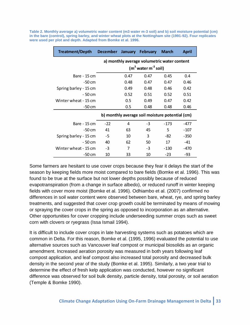
Climate Change Adaptation Using On-Farm Drainage Management in Delta 33
Table 2. Monthly average a) volumetric water content (m3 water m-3 soil) and b) soil moisture potential (cm) in the bare (control), spring barley, and winter wheat plots at the Nottingham site (1991-92). Four replicates were used per plot and depth. Adapted from Bomke et al. 1996.
Some farmers are hesitant to use cover crops because they fear it delays the start of the season by keeping fields more moist compared to bare fields (Bomke et al. 1996). This was found to be true at the surface but not lower depths possibly because of reduced evapotranspiration (from a change in surface albedo), or reduced runoff in winter keeping fields with cover more moist (Bomke et al. 1996). Odhiambo et al. (2007) confirmed no differences in soil water content were observed between bare, wheat, rye, and spring barley treatments, and suggested that cover crop growth could be terminated by means of mowing or spraying the cover crops in the spring as opposed to incorporation as an alternative. Other opportunities for cover cropping include underseeding summer crops such as sweet corn with clovers or ryegrass (Issa Ismail 1994).
It is difficult to include cover crops in late harvesting systems such as potatoes which are common in Delta. For this reason, Bomke et al. (1995, 1996) evaluated the potential to use alternative sources such as Vancouver leaf compost or municipal biosolids as an organic amendment. Increased aeration porosity was measured in both years following leaf compost application, and leaf compost also increased total porosity and decreased bulk density in the second year of the study (Bomke et al. 1995). Similarly, a two year trial to determine the effect of fresh kelp application was conducted, however no significant difference was observed for soil bulk density, particle density, total porosity, or soil aeration (Temple & Bomke 1990).
Treatment/Depth December January February March April
Bare - 15 cm 0.47 0.47 0.45 0.4
-50 cm 0.48 0.47 0.47 0.46
Spring barley - 15 cm 0.49 0.48 0.46 0.42
- 50 cm 0.52 0.51 0.52 0.51
Winter wheat - 15 cm 0.5 0.49 0.47 0.42
-50 cm 0.5 0.48 0.48 0.46
Bare - 15 cm -22 4 -3 -173 -477
-50 cm 41 63 45 5 -107
Spring barley - 15 cm -5 10 3 -82 -350
- 50 cm 40 62 50 17 -41
Winter wheat - 15 cm -3 7 -3 -130 -470
-50 cm 10 33 10 -23 -93
a) monthly average volumetric water content
(m3 water m-3 soil)
b) monthly average soil moisture potential (cm)

34 Climate Change Adaptation Using On-Farm Drainage Management in Delta
Reclaiming degraded soils in Delta that no longer drain well as a result of poor soil structure and reduced porosity, or from high levels of salinity was determined to be important for the long term vitality of farming in the region. Bomke et al. (1992; 1996) established a demonstration site (Figure 13) to show how a combination of treatments - subsurface tile drains, land levelling, the use of winter cover cropping with continued cash cropping, and a three year set-aside with forage – could reclaim degraded soils. The tile drains installed at 10 m spacing and 1.2 m depth improved drainage relative to no tile drains.
Figure 13. Reclamation site experimental layout. Source: (Bomke et al. 1992)
Interview Results
Demographic Information A total of 17 Delta farmers participated in the interview process between November 2014 and January 2015. All participants were at least second generation producers in the area; 12% were second generation only, 53% were third generation, 24% were fourth generation, and 12% were fifth generation. The ancestry of participants included European mix, Dutch, Indian, English, Irish, French, Canadian, and Chinese. The age of primary operators, operators who have the final say in the operational decisions for the agricultural operation, for the different farms were 6% below 35 years, 18% between 35 and 54 years, 41% over

Climate Change Adaptation Using On-Farm Drainage Management in Delta 35
55 years. Additionally, we found that often multiple generations were involved in the day-to-day operation of the farm (Figure 14) and so 35% of the farms were managed by multiple age groups.
Figure 14. Division of farms operated by different numbers of a) primary operators and b) secondary operators. Primary operators make operational decisions for the agricultural operation, while secondary operators participate in managerial discussions, but do not have the authority to make the final decision on an issue.
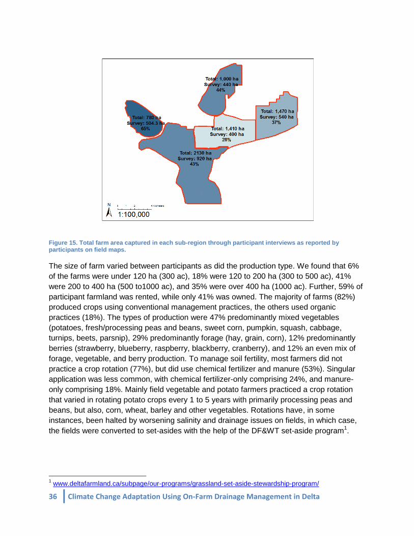
Farm Information In total 45% of farmable land in Delta was captured by the survey with 65% captured in Westham Island, 43% in Ladner South/Brunswick point, 28% in Ladner East/Boundary Bay, 44% in Crescent Slough, and 37% in East Delta (Figure 15). Most survey participants did not farm exclusively in one sub-region. Of the 17 participants, 6 farmed on Westham Island, 4 on Crescent Slough, 9 on Ladner South/Brunswick Point, 7 on Ladner East/Boundary Bay Airport, and 7 on East Delta land.
a)
b)
36 Climate Change Adaptation Using On-Farm Drainage Management in Delta
Figure 15. Total farm area captured in each sub-region through participant interviews as reported by participants on field maps.
The size of farm varied between participants as did the production type. We found that 6% of the farms were under 120 ha (300 ac), 18% were 120 to 200 ha (300 to 500 ac), 41% were 200 to 400 ha (500 to1000 ac), and 35% were over 400 ha (1000 ac). Further, 59% of participant farmland was rented, while only 41% was owned. The majority of farms (82%) produced crops using conventional management practices, the others used organic practices (18%). The types of production were 47% predominantly mixed vegetables (potatoes, fresh/processing peas and beans, sweet corn, pumpkin, squash, cabbage, turnips, beets, parsnip), 29% predominantly forage (hay, grain, corn), 12% predominantly berries (strawberry, blueberry, raspberry, blackberry, cranberry), and 12% an even mix of forage, vegetable, and berry production. To manage soil fertility, most farmers did not practice a crop rotation (77%), but did use chemical fertilizer and manure (53%). Singular application was less common, with chemical fertilizer-only comprising 24%, and manure-only comprising 18%. Mainly field vegetable and potato farmers practiced a crop rotation that varied in rotating potato crops every 1 to 5 years with primarily processing peas and beans, but also, corn, wheat, barley and other vegetables. Rotations have, in some instances, been halted by worsening salinity and drainage issues on fields, in which case, the fields were converted to set-asides with the help of the DF&WT set-aside program1.
1 www.deltafarmland.ca/subpage/our-programs/grassland-set-aside-stewardship-program/

Climate Change Adaptation Using On-Farm Drainage Management in Delta 37
Drainage and Salinity Problems
The majority of farmers experience flooding and salinity problems (as defined by the farmer) in their fields. Drainage is a concern for 76% of farmers, while 24% responded that drainage was either manageable or not a concern (Figure 16). Similarly, 76% of farmers identified salinity as a problem, while 24% said they did not have salinity problems.
Figure 16. Percent of farmers (n=17) that a) report drainage problems and b) report salinity issues.
The participants who responded that they are experiencing drainage problems were not the same as those who are having salinity problems. These issues are prominent at different times in the production season for farmers: the fall-winter period for drainage and the spring-summer period for salinity (Table 3). The combined impact of flooding and salinization of soils and irrigation water further limits farmers’ capacities to grow crops within the confines of the growing season. For the most part, the low-lying nature of Delta, which makes it productive for agriculture, was also identified as the dominant (41%) reason for fields facing the most extreme drainage issues; other reasons included farmers having ineffective personal drainage systems (24%), perception that the municipal drainage system was ineffective (6%) and proximity to the river (6%).
Table 3. Time of year farmers (n=17) reported their water table being highest, and having salinity issues.
When is water table highest?
When is salinity an
issue?
Winter 53 6
Winter/Spring 24
Spring 6
Summer 35
All year long 18 6
Not applicable 24
Not indicated 6 24
% Farmers
a) b)

38 Climate Change Adaptation Using On-Farm Drainage Management in Delta
The proportion drainage problems varied across the sub-regions (Figure 17) with: 2/6 farmers that have fields in Westham Island, 4/9 farmers for Ladner South/Brunswick Point, 1/7 farmers for Ladner East/ Boundary Bay, 2/4 farmers for Crescent Slough, and 5/7 farmers for East Delta. Higher incidence of drainage issues in Ladner South/Brunswick Point may be the result of higher clay content in the soil (Figure 17) which often causes massive soil structures with poor porosity resulting in very poor drainage. In East Delta, farmers reported problems with drainage due to low-lying fields and proximity to Burns Bog.
Figure 9. Occurrence of drainage problems a) reported by farmers (n=17) and b) soil clay content in Delta, BC. For each region, drainage problems are reported out of the number of farmers interviewed that farm fields in that region.
The proportion of salinity problems also varied across the subregions (Figure 18) with: 3/6 farmers that have fields in Westham Island, 5/9 farmers for Ladner South/Brunswick Point, 3/7 farmers for Ladner East/ Boundary Bay, 1/4 farmers for Crescent Slough, and 5/7 farmers for East Delta. Higher incidence of soil salinity in Ladner South/Brunswick Point reported by farmers was supported by measurements of higher electrical conductivity in the soil in that region (Figure 18). For East Delta, farmers reported salt water in ditches as a major concern.
a) b)

Climate Change Adaptation Using On-Farm Drainage Management in Delta 39
Figure 18. Occurrence of salinity on farmland a) reported by farmers (n=17) and b) digital soil survey map (as reported by electrical conductivity). For each region, salinity problems are reported out of the number of farmers interviewed that farm fields in that region.
On-Farm Drainage Systems The majority of farmers surveyed used a combination of surface and subsurface drainage management systems that were either considered less permanent or more permanent. Since many of the farming families have been in the region or on the same property for multiple generations, we were able to document changes in the drainage systems used. Farmers differentiated management practices that they used in the past but have discontinued, and practices that they are currently using.
Less permanent measures farmers reported using were mole drains, shallow surface drains, and subsoiling (Figure 19). Mole drains have been tried by most participants mainly before the 1960-1970s, however are still used experimentally or opportunistically today by farmers to complement their other practices. Mole drains have typically been dug by 10 to 13 cm (4 to 5 in) diameter torpedoes in the fall, at a depth range of 50 to 80 cm (20 in to 54 in) anywhere from 8 to 18 (25 to 60 ft) apart. Almost all farmers have stopped using mole drains because the drains tended to collapse within a year (due to the relatively low clay content in the soil), were plugged by rodents, or moved too much soil from the fields to ditches.
Shallow surface drains are used by most farmers currently, but with less frequency in terms of area covered than in the past. Surface drains were reported to range in depth from 20 to 90 cm (8 to 36 in). Some farmers reported digging the drains in the spring, while others reported digging drains in the fall. The reason farmers reported for digging in the spring, is to drain specific areas where water is ponding before planting; essentially to dry up the field as quickly as possible to increase the number of workable days for the year. The reason farmers reported for digging in the fall, is to create pathways for water to drain in case of heavy rainstorms. This activity is an easy fix for low or wet spots in fields. The need for this kind of work has largely been reduced by the ubiquity of laser levelling; however it is still a
a) b)

40 Climate Change Adaptation Using On-Farm Drainage Management in Delta
common practice. Farmers who have stopped altogether report the practice was too labour intensive or they were experiencing too great a loss of soil from fields into ditches in the winter months.
Subsoiling has been performed in Delta for 2 to 3 generations. Of the farmers who subsoiled, 64% performed their subsoiling in the fall, 21% spring and fall both, 7% spring only, and 7% did not specify the time of year they subsoiled. Subsoiling was reported ranging from 40 to 60 cm (16 to 24 in) deep (to break up the plow pan) and 50-60 cm (18 to 24 in) apart.
Figure 19. Less permanent measures that were practiced in the past or are currently practiced by farmers (n=17). A past measure is one that a farmer no longer uses in their farming operation but has used at an earlier time in their practice. A current measure is one that the farmer uses for regular operations today.
More permanent measures farmers reported using were cedar tile drains, clay tile drains, plastic (Big-O) tile drains, laser levelling, and ditches (Figure 20). The main reasons farmers have moved away from old drainage systems are that they are too labour intensive, no longer effective, and newer more efficient technologies have become available. For example, cedar tiles were reported by some of the older generation famers as being common practice from the 1900-1950s. Workers from the canneries, often Chinese, when out of work would be employed by farmers to hand dig ditches and install cedar blocks in a triangle or post and lintel formation for field drainage. The practice ceased as technology improved and the labour cost became too expensive.
Installed mainly from 1950-1970s, clay tiles were reported as effective. They have been installed anywhere from 60 to 120 cm (24 to 48 in) deep and 9 to 18 m (30 to 60 ft) apart. Generally, their performance was reported to be longer lasting than the plastic tiles; for this reason, though a general decline in new clay installations was reported, clay tiles are still reported as a highly used current measure as most farmers reported still receiving drainage benefit from their clay tiles. Installed from 1970s – present day, plastic tiles (also known as Big-O) are commonly used with 59% respondents having some type of plastic tile installed. Farmers reported that they installed tile drains anywhere from 20 to 120 m (9 to 48 in) deep
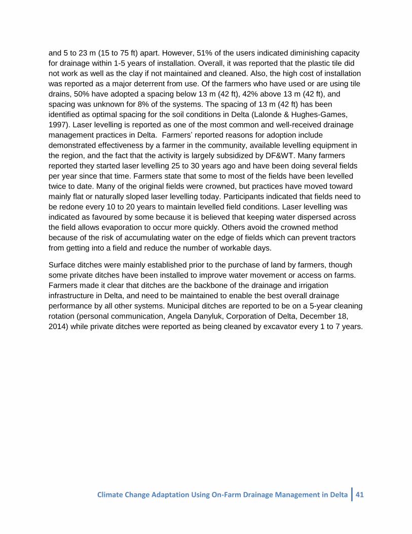
Climate Change Adaptation Using On-Farm Drainage Management in Delta 41
and 5 to 23 m (15 to 75 ft) apart. However, 51% of the users indicated diminishing capacity for drainage within 1-5 years of installation. Overall, it was reported that the plastic tile did not work as well as the clay if not maintained and cleaned. Also, the high cost of installation was reported as a major deterrent from use. Of the farmers who have used or are using tile drains, 50% have adopted a spacing below 13 m (42 ft), 42% above 13 m (42 ft), and spacing was unknown for 8% of the systems. The spacing of 13 m (42 ft) has been identified as optimal spacing for the soil conditions in Delta (Lalonde & Hughes-Games, 1997). Laser levelling is reported as one of the most common and well-received drainage management practices in Delta. Farmers’ reported reasons for adoption include demonstrated effectiveness by a farmer in the community, available levelling equipment in the region, and the fact that the activity is largely subsidized by DF&WT. Many farmers reported they started laser levelling 25 to 30 years ago and have been doing several fields per year since that time. Farmers state that some to most of the fields have been levelled twice to date. Many of the original fields were crowned, but practices have moved toward mainly flat or naturally sloped laser levelling today. Participants indicated that fields need to be redone every 10 to 20 years to maintain levelled field conditions. Laser levelling was indicated as favoured by some because it is believed that keeping water dispersed across the field allows evaporation to occur more quickly. Others avoid the crowned method because of the risk of accumulating water on the edge of fields which can prevent tractors from getting into a field and reduce the number of workable days.
Surface ditches were mainly established prior to the purchase of land by farmers, though some private ditches have been installed to improve water movement or access on farms. Farmers made it clear that ditches are the backbone of the drainage and irrigation infrastructure in Delta, and need to be maintained to enable the best overall drainage performance by all other systems. Municipal ditches are reported to be on a 5-year cleaning rotation (personal communication, Angela Danyluk, Corporation of Delta, December 18, 2014) while private ditches were reported as being cleaned by excavator every 1 to 7 years.
42 Climate Change Adaptation Using On-Farm Drainage Management in Delta
Figure 20. More permanent measures that were practiced in the past or are currently practiced by farmers (n=17). A past measure is one that a farmer no longer uses in their farming operation but has used at an earlier time in their practice. A current measure is one that the farmer uses for regular operations today.
To better manage on-farm drainage, 18% of farmers have established closed (controlled) drainage systems on their farms. However, most farmers (65%) have open (uncontrolled) systems and 18% have a combination of fields that have closed or open systems. To manage the movement of water from a closed system for either drainage or irrigation purposes 47% have one way stationary pumps, 35% of farmers do not have pumps to manage their water movement, 12% of farmers use portable pumps, and 6% have two-way pumps.
While subsurface drainage systems can often be used for sub-irrigation, we found that 59% used surface irrigation only on their farms, 29% percent did not irrigate at all, and 12% used a combination of surface and subsurface irrigation. When farmers did use irrigation, most specified that irrigation was necessary in July and August when precipitation was limited.
We found that 94% of farmers currently practice cover cropping. Crops that have been used for cover cropping include barley (50%), grass (31%), winter wheat (25%), tillage radish (19%), winter/fall rye (13%), mixed crops such as sunflower, sorghum, lentil, sugar beet, fava beans, and buckwheat (13%) and oats (6%). Several of the reasons farmers provided for cover cropping have direct and indirect benefits to on-farm water management (Figure 21).

Climate Change Adaptation Using On-Farm Drainage Management in Delta 43
Figure 21. Reasons farmers (n=16) provided for cover cropping.
Farmers reported a number of reasons as to why they selected their drainage systems including: appropriateness for size of field, production type, or soil type; generational knowledge along with optimization of the practice over the years; recommendations from other farmers or trusted organizations; seeing the positive effects on drainage and continually adopting the practice over a period of time; seeing the positive effects on crop yield, capacity to get on the field earlier in the season and increasing the total workable days; and cost considerations such as affordability to install and upkeep and/or receiving a subsidy.
On-farm Drainage System Alterations
Farmers had mixed responses about alterations they have made to their drainage systems to better respond to weather conditions (Figure 22) and their plans for implementation to respond to changing patterns in the future (Figure 23).

44 Climate Change Adaptation Using On-Farm Drainage Management in Delta
Figure 22. Drainage alterations farmers (n=17) reported making to better respond to weather conditions.
Figure 23. Percent of farmers (n=17) who a) responded they would make changes in the future to their on-farm drainage system, and b) of those who responded ‘Yes’ or ‘Maybe’ (59%), what activities they were considering for implementation.
While some farmers believe they can make effective changes to respond to shifts in the weather, others believe that there are too many variables to consider making effective on-farm management decisions to address the problems, particularly since ‘normal’ weather
conditions no longer exist in their opinion. For some, flooding was not an issue on their fields, and their systems were responsive even during heavy rain events. Overall it was reported that the response of drainage systems depends greatly on the fields (well vs. poorly drained), the nature of the rain event (heavy and short vs. moderate and long), the moisture content of the soil prior to the rain event, and the capacity to pump water out of the farm system.
a) b)

Climate Change Adaptation Using On-Farm Drainage Management in Delta 45
Climate Change Perceptions Farmer perceptions of climate change are difficult to assess. Farmers may recognize that weather patterns are changing and reactively adjust their management accordingly without acknowledging the impacts are related to climate change or shifting their long-term plans. In our interviews, although most of the farmers responded that drainage and salinity were problems, when asked directly about their perceptions of climate change, most of the farmers surveyed did not overtly recognize climate change projections as a part of their long-term management decision framework. Of the famers interviewed, 65% do not incorporate climate change projections for their region into their long-term planning. Reasons include: feeling no management option will effectively address the problem; focused on short-term management issues; impeded by the financial costs of action; limited by short-term leases; and waiting for a problem to present itself. 35% of the farmers surveyed consider climate change to be an issue of concern for their operation and have started to take action to alter their management practices to be better prepared. These actions include: focusing on ways to increase workable days; learning about disease and temperature tolerant cultivars; focusing on seed selection and choosing quick-growing varieties, early-maturing fescues and grasses; getting crops harvested as quickly as possible; being informed about the variation in conditions (soil and climate) within Delta; increasing capacity for shorter window of operation for planting and harvesting; anticipating 1 in 5 years will not be a good year; investing in land raising; avoiding soil-based agriculture in fields with severe drainage problems; and moving away from soil-based farming altogether (to cranberry or greenhouse production).
Research Priorities Identified by Farmers
These interviews were designed to elucidate the local understanding of drainage and salinity issues in the context of agricultural adaptation to changing weather conditions, and identify issues with the current drainage systems, but also to develop potential areas of research to improve on-farm drainage management decisions. Farmers were asked what future drainage research they would like to see performed. Three main themes emerged from the responses: drainage tile, salinity, and financial subsidy research (Figure 24). Farmers were interested in improving their drainage and salinity problems through alternative farm management, but identified financial constraints as a major obstacle.
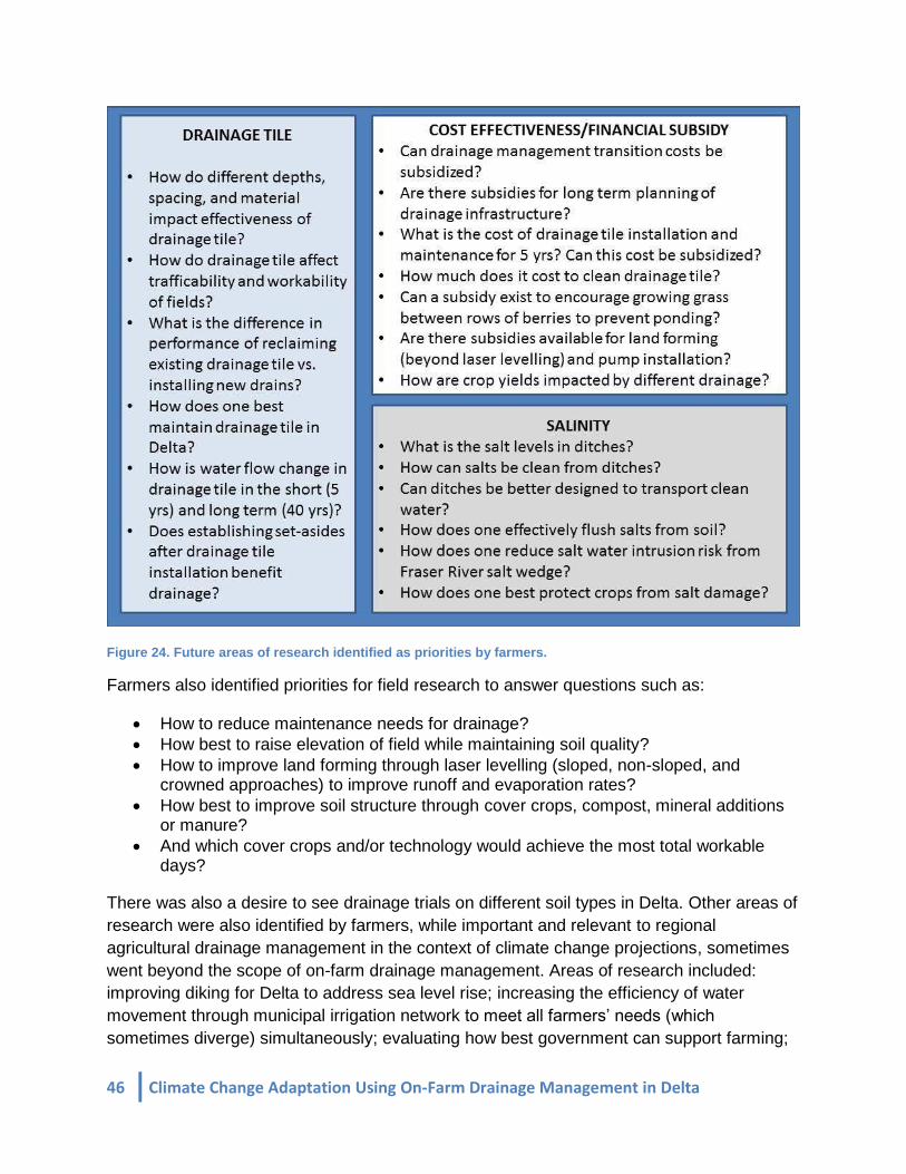
46 Climate Change Adaptation Using On-Farm Drainage Management in Delta
Figure 24. Future areas of research identified as priorities by farmers.
Farmers also identified priorities for field research to answer questions such as:
How to reduce maintenance needs for drainage? How best to raise elevation of field while maintaining soil quality? How to improve land forming through laser levelling (sloped, non-sloped, and
crowned approaches) to improve runoff and evaporation rates? How best to improve soil structure through cover crops, compost, mineral additions
or manure? And which cover crops and/or technology would achieve the most total workable
days?
There was also a desire to see drainage trials on different soil types in Delta. Other areas of research were also identified by farmers, while important and relevant to regional agricultural drainage management in the context of climate change projections, sometimes went beyond the scope of on-farm drainage management. Areas of research included: improving diking for Delta to address sea level rise; increasing the efficiency of water movement through municipal irrigation network to meet all farmers’ needs (which
sometimes diverge) simultaneously; evaluating how best government can support farming;

Climate Change Adaptation Using On-Farm Drainage Management in Delta 47
and improving communication with municipal staff. Finally, some farmers were more forward thinking and wished to know more about what drainage systems have worked in other areas with similar conditions to Delta.
Delta farmers reported financial constraints as a major obstacle to altering their farm management practices, and the literature supports that barriers expressed by farmers to making on-farm alterations are often economic (Bjornlund et al. 2009). For this reason, drainage activities in Delta may be better incorporated into farm management systems with the help of external organizations. To date, the most active sources of on-farm support are the B.C. Agriculture Council’s Environmental Farm Plan program
2, Delta Farmland and Wildlife Trust’s Environmental Stewardship programs
3, the Agricultural Land Development Assistance Program (discontinued), and Ducks Unlimited local agriculture support programs4.
The Environmental Farm Plan program was launched in 2003 and is a collaborative effort between Agriculture and Agri-food Canada, the BC Ministry of Agriculture and the BC Agriculture Research and Development Corporation5. The program provides farmers with a range of cost-shared funding levels for on-farm projects that improve the environmental sustainability of their operation including drainage best management practices. Delta farmers have used the program to install fencing, new fuel tanks, and chemical storage sheds, and to purchase GPS units for tractors, herder weed cutting buckets for cleaning ditches, and livestock waste management infrastructure (personal communications, November 2014 – January 2015). Many farmers in Delta have been actively involved with the DF&WT, a not-for-profit organization active since 1993 that provides incentives and cost sharing for sustainable soil management and the provision of wildlife habitat through activities including but not limited to: cover crops, grassland set asides, liming, and laser levelling (Merkens 2005). The Agricultural Land Development Assistance program, was active from 1975 -1990 as a provision under the Agricultural Credit Act by the B.C. Ministry of Agriculture and Food, but has since been discontinued. This program allowed for low interest loans to farmers for projects ranging from $5,000 - $75,000 amortized over 15 years at half the interest rate of the bank prime rate allowing many Delta farmers to make major capital investments into their land such as installing tile drains for improved drainage and subirrigation (Golder Associates 2003). Lastly, Ducks Unlimited, known for their environmental stewardship, has been providing support by encouraging sustainable soil management by promoting cover cropping and providing farmers with land tenure security through long-term leases of land they own.
2 https://www.bcac.bc.ca/ardcorp/program/environmental-farm-plan-program; retrieved February 20, 2015 3 http://www.deltafarmland.ca/page/our-programs/; retrieved February 20, 2015 4 http://www.ducks.ca/what-we-do/your-land/british-columbia-programs/; retrieved February 20, 2015 5 https://www.bcac.bc.ca/ardcorp/program/environmental-farm-plan-program; retrieved February 20, 2015

48 Climate Change Adaptation Using On-Farm Drainage Management in Delta
The interviews demonstrated that most farmers (94%) of the Delta farming community are already receiving monetary or other forms of support as described above for their farming activities (Figure 25).
Figure 25. Percentage (a) of farmers who receive or have received monetary support for various farm management activities, and (b) from which organization they receive support.
Discussion The flexibility of semi-structured interviews was important for this research because it allowed specific drainage and salinity questions to be addressed in relation to issues farmers felt were most important (e.g., local policies, specific farm or crop challenges). Overall, the demographics of the farmers interviewed were representative of the Delta community. A diversity of ancestry and generations of farming experience were captured, as were a variety of farm sizes, conventional and organic means of production, and different crop types. Further, the nearly equal proportion of rented to owned land farmed by respondents is consistent with the census findings for the broader farming community.
Results from this survey show that farmers in Delta vary in the way they perceive climate related problems and their desired approach to addressing them. Most farmers reported that they do not directly plan for predicted changes in climate in their operation. Reasons include, they currently do not find projected climate issues pressing enough relative to their other farm management activities, or they do not believe they can make changes to their drainage or salinity management that would effectively address current or future problems. When farmers did consider variable weather patterns in their planning, many of the changes farmers had made or planned to make were not directly drainage related (e.g., choosing alternative crop varieties). Regardless of their view of climate change, it was clear from the farmer interviews, that the majority recognized drainage management and soil salinization as serious problems. While the exact reasons why these problems persist are unknown, there are a number of potential causes:
a) b)

Climate Change Adaptation Using On-Farm Drainage Management in Delta 49
It may be the extensive research that has been conducted in Delta has not identified optimal solutions to the problem, or as climate models suggest, these problems have become a moving target.
It is also possible that the findings of past research materials are not available in a format that is readily accessible to farmers.
It is a possibility that farmers have the required information to make sound management decisions but are hampered by onerous financial and/or policy barriers.
Our research suggests that drainage and soil salinity problems persist due to a combination of these issues.
We have reviewed and compiled a large amount of information generated through decades of research on drainage and soil salinity in Delta. Findings show, some drainage management practices investigated have been adopted on a wide-scale (e.g., laser levelling). Others are not as widely used such as plastic drainage tiles and closed (controlled) systems. Farmers consistently stated an interest in increasing their knowledge about drainage tiles and increasing the affordability of installing closed systems. Specifically, for drainage tiles, farmers reported wanting to determine optimal spacing, depth, and length for new installations to address the needs of different crops, soil types, and climatic conditions. The research projects investigating many of these issues in Delta have now been compiled, and we have identified that the projects may have had limited applicability given a lack of replication across various crop and soil types found in Delta. Farmers reported improving workability and trafficability of their field particularly in the spring as a crucial previous studies that focused on optimizing workability and trafficability (Prasher et al. 1985; Odhiambo & Bomke 2007; Hermawan 1995; Gao 1990; Prasher 1982) may need to be revisited because of changing landscape conditions, management practices, and weather patterns.
While existing resources provide guidance on how to maintain tile drains for optimal function (e.g. to protect from iron ochre in iron rich soils) (British Columbia Ministry of Agriculture and Food 1988), minimal information is provided about the benefits of maintaining tile drains in terms of crop yield, soil structure, or drainage flows. Farmers interviewed often indicated they were considering improving their subsurface drainage capacity more often by installing new tile drains, rather than cleaning or maintaining poorly functioning ones. Although other provinces have provided a relative cost-benefit analysis of new installation verses maintenance (e.g., Ontario), this has not been investigated in Delta. Recommendations in Ontario specify that subsurface drains should be maintained to manage the buildup of sediment and iron ochre but if the projected costs of maintaining existing drainage tile exceeds 70% of the cost of installing new drains, new drainage should be installed instead (OMAFRA, 2013).
Most farmers have adopted cover cropping and/or set-aside practices and several reported experimenting with different seed mixes or crop types to optimize the desired outcomes.

50 Climate Change Adaptation Using On-Farm Drainage Management in Delta
Tillage radish for example, was noted as being particularly beneficial because of its deep-rooting abilities to promote drainage. Additionally, the above-ground component of tillage radish has been reported to die-off in the winter reducing soil moisture levels in the spring compared to crops that leave surface residues. Farmers have reported dense surface residues prevent early field access. Despite these anecdotal benefits, there is little published research on this cover crop, and none has been conducted in Delta.
Interviewed farmers recognized the benefits of closed or controlled drainage systems, and many stated they would be interested in converting their management system to one that is closed. Reasons for converting their system were to mitigate competing water needs from neighbours, to effectively keep the water table at a desired depth, and to flush salts from their fields if present. Indeed there has been substantive research demonstrating the value of closed or controlled drainage systems for reducing soil moisture in the root zone, at times reducing surface runoff, and increasing the trafficability and workability of a field. This is a situation where a lack of research is likely not the barrier for adoption. Obstacles to farmers adopting closed systems include: access problems because of variable ‘right-of-ways’ being
controlled by the Corporation of Delta (personal communication, Angela Danyluk, December 18, 2014); policies that protect habitat by preventing the alteration of regional drainage patterns (Ministry of Agriculture 2005); and most notably, installation costs.
Salinity problems clearly remain a widespread concern among the farmers interviewed. Strategies to mitigate soil salinity in Delta identified in previous research (Bomke et al. 1992) have been adopted by some of the interviewed farmers. For example, farmers have adopted practices of installing tile drains below salt affected fields, and putting the field into set-aside for multiple years to improve the drainage on the site with the goal of flushing salts from the soil with heavy winter rains. Alternatively, farmers who have reported being primarily salt affected by high levels of irrigation water in summer months have opted to either monitor salt levels or to stop irrigating their crops altogether. The cost for installing tile drains and taking land out of production for set-asides to reclaim salt affected areas are prohibitive and the cost and benefits unclear. It is also unclear how long set-asides need to be in place to optimize their benefit, and ultimately what the returns are for such an investment.
Unfortunately, it was not discernable from the interview process whether farmers who reported needing more information had reviewed the available published research materials, or if these materials were in a format that is accessible, straightforward, or helpful for addressing the issues about which farmers are concerned. We can report that locating many of the research documents was challenging, and farmers could very well have difficulty locating the desired information. Further, some of the research materials may be out-dated or irrelevant in terms of economic evaluation, the spacing of the drainage systems, or farmers may have perceived the information as not being applicable to the conditions of their fields.

Climate Change Adaptation Using On-Farm Drainage Management in Delta 51
Other barriers for adopting appropriate drainage management practices, beyond the existence and availability of information, need to be recognized. The availability of financial support is important when considering the likelihood of farmers to adopt alternative management practices. In southern Alberta, a study investigating the adoption of more efficient irrigation technology, found farmers that were more reliant on irrigation for crop production, and who participated in more government support programs (i.e. crop insurance, income stabilization program, environmental farm plan program, or energy subsidies) were more likely to adopt new technologies (Bjornlund et al. 2009).
In Delta, drainage and salinity management have been identified as critical for profitable crop productions by farmers, and as such have been, are currently, and will likely continue to have financial support mechanisms in place indicating that farmers in this region are more likely to adapt their on-farm management practices than other areas. For example, adoption of practices such as laser levelling, cover crops and set-asides may have been enhanced because of the financial support provided by DF&WT and Ducks Unlimited. Bjorlund et al. (2009) also suggest cash subsidies are needed along with a substantial increase in commodity prices to stimulate adoption of new on-farm management technologies. Further, since farmers are generally risk adverse (e.g., not willing to invest capital into projects that do not have clear economic benefit), affordable management options that support, or draw on, existing farm management knowledge and skills are preferred relative to complex technological fixes (Bjornlund et al. 2009). Finding appropriate subsidy mechanisms to address specific drainage management practices, such as installing and maintaining tile drains, or converting open systems to closed (controlled) systems, will likely be important for farmers to alleviate drainage and salinity problems. Furthermore, these mechanisms must be designed to address the prevalence of short-term land tenures that prevents farmers from making long-term investments (Zbeetnoff Agro-Environmental Consulting & Quadra Planning Consultants Inc. 2011).
Other factors that could influence the adoption and/or incentives of drainage management practices include adverse environmental impacts of farmland drainage systems, regional policies and resources, and biophysical barriers. As discussed in the literature review, drainage systems can degrade natural habitat (Glenn et al. 1996), cause sedimentation (Lecce et al. 2006), or increase nutrient leaching (Tan et al. 2002). Delta is not isolated from such concerns. The impacts of changes to on-farm drainage on natural systems, particularly with the proximity of sensitive ecosystems such as the Boundary Bay estuary and Burns Bog, should be considered.
Another key issue identified by farmers (59%) was the need to enhance municipal drainage coordination with the Corporation of Delta to enhance the effectiveness of shared resources such as pumps, ditches, floodboxes, and water intake stations for improved drainage and irrigation. Further, pressures to meet competing demands for land use in Delta make it difficult to secure land for long term; for example, 207 ha of agricultural land was recently signed over to the Tsawwassen First Nations some of which is currently being leased by the

52 Climate Change Adaptation Using On-Farm Drainage Management in Delta
First Nations band to farmers (Zbeetnoff Agro-Environmental Consulting & Quadra Planning Consultants Inc. 2011). Biophysical challenges include the wide array of soil types, crop production, and local weather patterns across Delta, as well as damming of ditches by local beavers or compaction of surface soil by waterfowl.
Conclusions and Options for Action
From this research, it is clear that Delta farmers recognize flooding and excess soil moisture are important obstacles for production, but struggle to find a clear solution to remediate their drainage problems. Similarly, farmers are having problems with salinity in spite of their management efforts, and questions remain on how best to remove excess salt from both the soil and open ditch irrigation water in a cost effective way. Results of this study have shown that financially supported practices such as laser levelling (more permanent), cover crops, and set-asides, as well as proven techniques such as subsoiling (less permanent) are the most used drainage management strategies in Delta. It is clear that there are substantial hurdles for the adoption of promising drainage management practices such as subsurface drainage tiles/tubing. These hurdles include installation and maintenance costs, and concerns about investing in lands without secure tenure. Our results also show that some farmers are attempting to mitigate the effects of changing weather patterns by growing alternate crops that are less weather sensitive, increasing planting and harvesting capabilities, and accepting a loss of production once every few years.
The results of our literature review and interviews highlight the need to address: information and outreach gaps, regional management, communication between farmers, and farmers and the municipality, and relevant policies to successfully enable farmers to manage their drainage and salinity problems. To address the concerns highlighted in the literature review and interviews that future research should target tile drain spacing to accommodate increased precipitation intensity and provide cost benefit analysis across the variable farming landscape in Delta. This information should be used to update and enhance existing drainage and soil salinity management resources. Finally, it is clear from this study that providing information is not enough to ensure the adoption of practices that will enable farmers to adapt to future climate related challenges in Delta. Given the positive response reported by the farmers to cost share initiatives provided by the DF&WT or the Environmental Farm Plan, incentive programs for the adoption of appropriate drainage and soil salinity management practices in the context of short-term land tenure should be investigated.

Climate Change Adaptation Using On-Farm Drainage Management in Delta 53
References
Abdel-dayem, S., Abdel-gawad, S. & Fahmy, H., 2007. Drainage in Egypt: A story of determination, continuity, and success. Irrigation and Drainage, 56, pp.101–111.
Agarwala, S., 1992. Modeling of Water Table Profile for a Subirrigation System and Evaluation of Reliability of Drainmod for the Lower Fraser Valley. pp. 1-80
Agriculture and Agri-Food Canada, 2010. Detailed Soil Survey, British Columbia version 3, (digital map and database at 1:50000 scale) Retrieved January 2015 from: http://sis.agr.gc.ca/cansis/nsdb/dss/v3/index.html
Aragüés, R., V. Urdanoz, M. Cetin, C. Kirda, H. Daghari, W. Ltifi, M. Lahlou, & A. Douaik, 2011. Soil salinity related to physical soil characteristics and irrigation management in four Mediterranean irrigation districts. Agricultural Water Management, 98, pp.959–966.
B.C. Agriculture & Food Climate Action Initiative, 2013a. BC Agriculture & Climate Change Regional Adaptation Strategies series: Delta., pp. 1-39
B.C. Agriculture & Food Climate Action Initiative, 2013b. BC Farm Practices & Climate Change Adaptation: Drainage, pp.1-24
B.C. Ministry of Agriculture and Food, 1988a. B.C. Drainage Factsheet: Iron Ochre Problems in Agricultural Drains, pp.1-2
B.C. Ministry of Agriculture and Food, 1988b. B.C. Drainage Factsheet. Iron ochre control methods - A literature review, pp.1-6
B.C. Ministry of Agriculture, Food and Fisheries, 1982. Subsoiling , pp.1–10.
Bjornlund, H., Nicol, L. & Klein, K.K., 2009. The adoption of improved irrigation technology and management practices—A study of two irrigation districts in Alberta, Canada. Agricultural Water Management, 96(1), pp.121–131.
Bomke, A.A., L.E. Lowe, M.D. Novak, & W.D. Temple, 1992. Conservation Farming Systems in the Western Fraser Valley. 1991-92 Annual Report of the UBC Soil and Water Conservation Group, pp.1-28
Bomke, A.A., L.E. Lowe, M.D. Novak, & W.D. Temple, 1996. Conservation Farming Systems in the Western Fraser Valley. Final Report for Project #S2205; Canada-British Columbia Soil Conservation Agreement, pp.1-47
Bomke, A.A., S.B. Traichel, W.D. Temple, & J.M. Rogers, 1995. Suitability of Vancouver leaves and leaf compost for amending agricultural soils, pp.1-84

54 Climate Change Adaptation Using On-Farm Drainage Management in Delta
Boyle, C.A., L. Lavkulich, H. Schreier, & E. Kiss, 1997. Changes in Land Cover and Subsequent Effects on Lower Fraser Basin Ecosystems from 1827 to 1990. Environmental Management, 21(2), pp.185–196.
Bryant, C., B. Smit, M. Briklacich, T.R. Johnston, J. Smithers, Q. Chiotti, & B. Singh., 2000. Adaptation in Canadian Agriculture to Climatic Variability and Change. Climatic Change, 45, pp.181–201.
Buckland, G.D., Harker, D.B. & Sommerfeldt, T.G., 1986. The influence of drain depth on the rate of soil reclamation in irrigated areas of Southern Alberta. Canadian Journal of Soil Science, 66, pp.531–535.
Buckland, G.D. & Hendry, M.J., 1992. Groundwater response and salt removal in a saline-seep soil in southern Alberta. Canadian Agricultural Engineering, 34(2), pp.125–134.
Castanheira, P.J.N. & Serralheiro, R.P., 2010. Impact of mole drains on salinity of a vertisoil under irrigation. Biosystems Engineering, 105(1), pp.25–33.
Chao, E.C.Y., 1987. Water Table Depth Simulation for Flat Agricultural Land Under Subsurface Drainage and Subirrigation Practices. pp. 1-93
Chieng, S.T., Keng, J. & Driehuyzen, M.G., 1987. Effects of subsurface drainage and subirrigaiton on the yields of four crops. Canadian Agricutural Engineering, 29(1), pp. 21-26
Crawford, E. & Beveridge, R., 2013. Strengthening BC ’s Agriculture Sector in the Face of Climate Change, pp. 1-20
Dakin, A., 2014. Chapter 9 — Ground Water Resources of the Basins, Lowlands and Plains. Ground Water Resources of British Columbia. Available at: http://www.env.gov.bc.ca/wsd/plan_protect_sustain/groundwater/gwbc/C0911_Fraser_Lowland.html.
Delta Farmland and Wildlife Trust, 2011. Program Overview and Co-operator Guidelines: Land Laser Levelling, pp. 1-2
Driehuyzen, M.G., 1985. Boundary Bay Water Control Project - report 1985, pp. 1-53
Droy, N., 2010. Lowland Agricultural Land Drainage Systems: Function and modification for wetland conservation, pp. 1-23
Environment Canada. 2014. Canadian climate normals 1981-2010 Station Data. Retrieved September 27, 2014 from: http://climate.weather.gc.ca/climate_normals/results_1981_2010_e.html?stnID=766

Climate Change Adaptation Using On-Farm Drainage Management in Delta 55
&lang=e&StationName=Delta+&SearchType=Contains&stnNameSubmit=go&dCode=0 on
Evans, R., Skaggs, W. & Sneed, R.E., 1996. Economics of Controlled Drainage and Subirrigation Systems, pp. 1-19
Filipovic, V., F.J.K. Mallmann, Y. Coquet, & J. Simunek, 2014. Numerical simulation of water flow in tile and mole drainage systems. Agricultural Water Management, 146, pp.105–114.
Gao, Y., 1990. Influence of Subsurface Drainange and Subirrigation Practices on Soil Drainable Porosity. pp. 1-102
Gartley, C., L. Cochrane, R. DeHaan, & A. Madani, 1986. Farm Drainage in the Atlantic Provinces. , pp.1–20.
Glenn, E.P., C. Lee, R. Felger, & S. Zengels, 1996. Effects of Water Management on the Wetlands of the Colorado River Delta , Mexico. Conservation Biology, 10(4), pp.1175–1186.
GMV Engineering, 2012. Retrieved February 2015 from: http://gmveng.ca/
Golder Associates, 2003. Analysis of Agricultural Water Supply Issues: National Water Supply Expansion Program British Columbia, pp. 1-104
Grigg, B.C., L.M. Southwick, J.L. Fouss, & T.S. Kornecki, 2003. Drainage System Impacts on Surface Runoff, Nitrate Loss, and Crop Yield on a Southern Alluvial Soil. Transactions of the ASAE, 46(6), pp.1531–1537.
Hall, K.J. & Schreier, H., 1996. Urbanization and agricultural intensification in the Lower Fraser River valley : Impacts on water use and quality. GeoJournal, 40.1(2), pp.135–146.
Hanson, T., 2010. Holding the Line: The Value of Agricultural Land in Delta, BC. pp. 1-96
Hemmera, 2012. Environmental Assessment Report: Deltaport Terminal Road and Rail Improvement Project, pp. 1-450
Hermawan, B., 1995. Soil Structure Associated with Cover Crops and Grass Leys in Degraded Lowland Soils of Delta. pp. 1-154
Herzon, I. & Helenius, J., 2008. Agricultural drainage ditches, their biological importance and functioning. Biological Conservation, 141, pp.1171–1183.

56 Climate Change Adaptation Using On-Farm Drainage Management in Delta
Howie, S.A., P.H. Whitfield, R.J. Hebda, T.G. Munson, R.A. Dakin, & J.K. Jeglum, 2009. Water Table and Vegetation Response to Ditch Blocking: Restoration of a Raised Bog in Southwestern British Columbia. Canadian Water Resources Journal, 34(June), pp.381–392.
Issa Ismail, A.A., 1994. Establishment and Evaluation of Cover Crops Underseeded in Sweet Corn in Delta, British Columbia. pp. 1-78
Krzic, M., Fortin, M. & Bomke, A.A., 2000. Short-term responses of soil physical properties to corn tillage-planting systems in a humid maritime climate. Soil and Tillage, 54, pp.171–178.
Lalonde, V., C.A. Madramootoo, L. Trenholm, & R.S. Broughton, 1996. Effects of controlled drainage on nitrate concentrations in subsurface drain discharge. Agricultural Water Management, 29, pp.187–199.
Lalonde, V. & Hughes-Games, G., 1997a. B.C. Agricultural Drainage Manual. Chapter 1: Introduction, pp. 2-4
Lalonde, V. & Hughes-Games, G., 1997b. B.C. Agricultural Drainage Manual. Chapter 11: Controlled Drainage and Subirrigation, pp. 234-244
Lalonde, V. & Hughes-Games, G., 1997c. B.C. Agricultural Drainage Manual. Chapter 6: Benefits of Drainage, pp. 85-96
Lecce, S., Gares, P. & Pease, P., 2006. Drainage Ditches as Sediment Sinks on the Coastal Plain of North Carolina. Physical Geography, 2, pp.447–463.
Liu, A., 1995. Soil Organic Components and Aggregation as Influenced by Cover and Ley Crops. pp. 1-97
Liu, A., Ma, B.L. & Bomke, A.A., 2005. Effects of Cover Crops on Soil Aggregate Stability, Total Organic Carbon, and Polysaccharides. Soil Science Society of America Journal, 69(6), pp.2041–2048.
Luttmerding, H.A., 1981. Soils of the Langley-Vancouver Map Area. Report No. 15. Volume 3 Description of Soils, pp. 1-242
Luttmerding, H.A. & Sprout, P.N., 1969. Soil Survey of Delta and Richmond Municipalities, pp. 1-132
Manitoba Agriculture, Food, and Development, 2015. Retrieved March 12, 2015 from: http://www.gov.mb.ca/agriculture/environment/soil-management/soil-management-guide/drainage-management.html

Climate Change Adaptation Using On-Farm Drainage Management in Delta 57
Mastrocicco, M., N. Colombani, D. Di Giuseppe, B. Faccini, & M. Coltorti, 2013. Contribution of the subsurface drainage system in changing the nitrogen speciation of an agricultural soil located in a complex marsh environment (Ferrara, Italy). Agricultural Water Management, 119, pp.144–153.
McNamara, K., 2011. Small Farms and Climate Change Adaptation in British Columbia. pp. 1-89
Mejia, M.N., Madramootoo, C. A. & Broughton, R.S., 2000. Influence of water table management on corn and soybean yields. Agricultural Water Management, 46, pp.73–89.
Merkens, M., 2005. Partners in Stewardship : An Example of Using Incentives for Agricultural Wildlife Habitat Enhancement. In Species at Risk 2004 Pathways to Recovery Conference. pp. 1–12.
Metro Vancouver, 2012. 2011 Census of Agriculture Bulletin (Agriculture in Metro Vancouver), pp. 1-16
Miller, M.R., P.L. Brown, J.J. Donovan, R.N. Bergatino, J.L. Sonderegger, & F.A. Schmidt, 1981. Saline seep development and control in the North American Great Plains - Hydrogeological aspects. Agricultural Water Management, 4, pp.115–141.
Ministry of Agriculture and Food, 1998. B.C. Drainage Factsheet. Controlled Drainage/Subirrigation, pp. 1-10
Ministry of Agriculture and Food, 2000. B.C. Drainage Factsheet. Drain filters and envelopes, pp. 1-4
Ministry of Agriculture, Food and Fisheries, 2005. B.C. Watercourse Maintenance Factsheet. Agency Contact Requirements for Channelized and Natural Stream Maintenance, pp. 1-6
Minitab, 2014. Retrieved January 2015 from: http://support.minitab.com/en-us/minitab/17/topic-library/modeling-statistics/multivariate/item-and-cluster-analyses/linkage-methods/
Ng, H.Y.F., C.S. Tan, C.F. Drury, & J.D. Gaynor, 2002. Controlled drainage and subirrigation influences tile nitrate loss and corn yields in a sandy loam soil in Southwestern Ontario. Agriculture, Ecosystems & Environment, 90(1), pp.81–88.
Nijland, B.H.J., Croon, F.W. & Ritzema, H.P., 2005. Subsurface Drainage Practices: Guidelines for the implementation , operation and maintenance of subsurface pipe drainage systems, pp. 1-180

58 Climate Change Adaptation Using On-Farm Drainage Management in Delta
Odhiambo, J.J.O. & Bomke, A.A., 2007. Cover crop effects on spring soil water content and the implications for cover crop management in south coastal British Columbia. Agricultural Water Management, 88(1-3), pp.92–98.
OMAFRA, 2013. Ontario Ministry of Agriculture, Food and Rural Affairs. Retrieved March 12, 2015 from: http://www.omafra.gov.on.ca/english/engineer/facts/13-037.htm
Opus International Consultants. 2014. Chillukthan Slough—Delta, BC. Retrieved October 5, 2014. from: http://www.opusdaytonknight.ca/projects/chillukthan-slough-delta-bc/
Posthumus, H., C.J.M. Hewett, J. Morris, & P.F. Quinn, 2008. Agricultural land use and flood risk management: Engaging with stakeholders in North Yorkshire. Agricultural Water Management, 95, pp.787–798.
Prasher, S.O., S.O. Russell, S.T. Chieng, & T.H. Podmore, 1985. A Probabilistic Approach to Agricultural Drainage Design. Transactions of the ASAE, 28(5), pp.1494–1498.
Prasher, S.O., 1982. Examination of the Design Procedures for Drainage/Subirrigation Systems in the Lower Fraser Valley, British Columbia. pp. 1-213
R Core Team, 2014. R: A language and environment for statistical computing. R Foundation for Statistical Computing, Vienna, Austria. URL http://www.R-project.org/.
Richard, P.F., 1988. A Computer Analysis of the Flow of Water and Nutrients in Agricultural Soils as Affected by Subsurface Drainage. pp. 1-197
Robinson, M. & Armstrong, A.C., 1988. The extent of agricultural field drainage in England and Wales, 1971-80. Transactions of the Institute of British Geographers, 13(1), pp.19–28.
Robinson, M. & Gibson, H., 2011. Assessing the status of drainage in the UK, pp.1-12
Singh, R., Helmers, M.J. & Qi, Z., 2006. Calibration and validation of DRAINMOD to design subsurface drainage systems for Iowa’s tile landscapes. Agricultural Water Management, 85, pp.221–232.
Skaggs, R.W., Youssef, M. A. & Chescheir, G.M., 2012. DRAINGMOD: model use, calibration, and validation. Transactions of the ASABE, 55(4), pp.1509–1522.
Smedema, L.K., Vlotman, W.F. & Rycro, D., 2004. 4.1 Pipe Drain Systems. In Modern Land Drainage: Planning, Design and Management of Agricultural Drainage Systems. pp. 60–63.

Climate Change Adaptation Using On-Farm Drainage Management in Delta 59
Statistics Canada, 2015. Glossary. Retrieved March 12, 2015 from: http://www.statcan.gc.ca/eng/ca2011/gloss
StatSoft, 2015. Cluster Analysis. Retrieved January 2015 from: http://www.statsoft.com/Textbook/Cluster-Analysis, retrieved January 2015
Stringer, L.C., A.J. Dougill, E.Fraser, K. Hubacek, C. Prell, & M.S. Reed, 2006. Unpacking “participation” in the adaptive management of social ecological systems: A critical review. Ecology and Society, 11(2), p.22.
Tan, C.S., C.F. Drury, W.D. Reynolds, P.H. Groenevelt, & H. Dadfar, 2002. Water and nitrate loss through tiles under a clay loam soil in Ontario after 42 years of consistent fertilization and crop rotation. Agriculture, Ecosystems and Environment, 93(1-3), pp.121–130.
Temple, W.D. & Bomke, A.A., 1990. The short-term effects of fresh kelp (Macrocystis integrifolia) on physical properties of a fine-textured soil. Plant and Soil, 125, pp.293–295.
Temple, W.D., Lewis, D. & Bomke, A., 2011. Delta Farmers’ Institute & UBC Faculty of Land and Food Systems. Interim Report. Eco-Friendly Crop Rotations, pp. 1-85
Vander Veen, S., 2010. Operating and Maintaining a Home Irrigation System, pp. 1-4
Zbeetnoff Agro-Environmental Consulting & Quadra Planning Consultants Inc., 2011. Delta Agricultural Plan. Phase 2 Report : Issues and Options, pp. 1-49

60 Climate Change Adaptation Using On-Farm Drainage Management in Delta
Appendix
A. Delta Drainage and Sub-Irrigation Project | Producer Interview Guide
The following list of questions is designed to guide the interview and is not designed to be a strict question and response process. The interview is expected to take between 60-90 minutes.
Demographic & Background Questions
1. How long have you been a farmer in Delta, BC? How did you come to the industry? 2. In what age category do you fall?
a. < 35 yrs, 35-54 yrs, over 55 yrs 3. Do you receive support from any institution or community organization (eg. Ducks Unlimited,
DF&WT, (old) Alda) for any of your farming activities (eg credit, farmer extension, incentives, tax deductions) ? If so, which activities?
4. How many acres do you farm? Is it owned, rented, or some of both? 5. Where are your fields on the map? 6. Are your fields for berry, forage (includes corn/grass), or vegetable (includes grain/barley/set
asides part of veg. rotation) production? If so, how many of each? Other? (MAP) 7. Please describe your crop rotation if any for your different crops. 8. Do you apply manure or chemical fertilizer? Is this different in different fields? If so which
ones? (MAP) 9. Typically, at what time of year is your water table highest, and how high is it? 10. Are there fields that have problems with drainage? (MAP) 11. Are there fields that never have problems with drainage? (MAP) 12. Are there fields that you have issues with salinity? (MAP)
Drainage and Irrigation Questions
13. What kind of drainage and irrigation system(s) do you use – surface, subsurface, a combination, or none for each of these fields (MAP)?
If answered subsurface only:
14. Do you use temporary measures (mole drains/subsoiling) or permanent measures (ditch/tile drainage)?
15. If temporary, what time of year do you perform subsoiling? 16. How deep is your subsurface drainage? How far are channels spaced? 17. Is your system open or closed (privately controlled)? 18. Do you have a one-way or two-way pump? 19. When (season, months of the year) do you drain and when do you irrigate?
If answered surface only:
20. Do you use temporary measures (shallow surface drains –eg in winter) or permanent measures (ditches, surface grading, laser levelling, or fill)?
21. Is cover cropping or residue management used to protect field surfaces? 22. What kind of surface irrigation (drip included) system do you use? And why? If answered a combination of subsurface and surface: 23. What combinations do you use?

Climate Change Adaptation Using On-Farm Drainage Management in Delta 61
a. Subsurface temporary and surface temporary b. Subsurface permanent and surface temporary c. Subsurface temporary and surface permanent d. Subsurface permanent and surface permanent
24. If temporary, what time of year do you perform subsoiling? 25. How deep is your subsurface drainage? How far are channels spaced? 26. Is your system open or closed (privately controlled)? 27. Do you have a one-way or two-way pump? 28. Is cover cropping or residue management used to protect field surfaces? 29. When (season, months of the year) do you drain and when do you irrigate? 30. What kind of surface irrigation (drip included) system do you use? And why?
If answered none (no laser leveling or subsurface drainage): 31. Why are these not drained?
General
32. Why do you use these systems? 33. How old are your systems? 34. Have you ever used another drainage system? If so, why do you no longer use that system? 35. Have you ever used another irrigation system? If so, why do you no longer use that system? 36. Do you currently have drainage problems in your fields? If so which ones? 37. How well does your current system respond to typical weather conditions? 38. How well did your system respond to past storms? Are there any in particular storms that
stand out in your mind? (e.g. Summer 2010, January 1988, December 1982) 39. Where do you get information about drainage technologies or how to drain/irrigate your
fields?
Climate Change Questions
40. Have you made any alterations to your drainage system(s) to adapt to changes in the weather? 41. Do you plan to make changes to your drainage system(s) to adapt to events like the 2010
storm in the future? If yes, what changes do you plan to make? 42. Is there information that would support you in making these decisions about future changes? 43. If we were to do some research on drainage and subirrigation in Delta, BC, what research
would you like to see done? 44. Do you take climate change outcomes such as increased flooding from higher intensity or
prolonged rain events into consideration for your on-farm planning and for future generations on your farm?

62 Climate Change Adaptation Using On-Farm Drainage Management in Delta
B. Adaptation to Climate Change in Delta BC: Interview Consent Form Full title: Drainage on Farms: Adaptation to Climate Change in Delta BC Who is doing the study?: Investigator: Bryanna Thiel Graduate student, Faculty of Land and Food Systems, UBC 604-220-7389; [email protected] Co-Investigator: Gladys Oka Graduate student, Faculty of Land and Food Systems, UBC 604-783-6977; [email protected] Supervisor: Dr. Sean Smukler Associate Professor, Faculty of Land and Food Systems, UBC 604-728-2816; [email protected] Why are we doing the study?: To understand the limitations to, and opportunities for, adaptation to climate change related to increased rainfall or sea level rise on farmland in Delta, British Columbia. As a key actor within Delta, BC, your input will help us define a local vision for adaptation, identify issues within the current drainage systems, and develop potential areas of research to improve on-farm drainage management decisions. What we are asking of you?: Participants are asked to complete a single-stage interview process. The in-person interview will take between 60-90 minutes. The interview will take place at a time and date that is convenient to the participant. During the interview, you will be asked to share information about how you manage your drainage on-farm, what issues you have faced in the past, what solutions you believe are viable in the future, and also what biophysical information about your farm would be valuable to you for making different management decisions in the future. We will also need to know a little about your personal and work history for comparison with other farmers. There are no anticipated risks or direct benefits to participants, but we hope that this research will benefit current and potential Delta, BC farmers at being able to better cope with a changing climate. What will we do with the findings?: With your permission, these interviews will be audio-recorded for analysis. Results from interviews will be used by Bryanna Thiel, Gladys Oka, and Dr. Sean Smukler in the Faculty of Land and Food Systems at UBC, for a report that will be presented to a representatives from the Delta Farmer’s Institute, the BC Ministry of Agriculture, and BC Climate
Action. Results may also be included in reports produced by these organizations , in public media (eg. newspaper articles), or published in academic journals. The data from this research may be kept for future comparative studies by Dr. Sean Smukler. If you would like a copy of the final report sent directly to you please contact Bryanna Thiel at [email protected]. How will your privacy be maintained?: All data will be kept on a secure hard-drive in a locked research facility. Your personal responses will be strictly confidential and only accessible to the UBC research team (individuals listed above). Your name will not be used in any research publication, nor will any other information that clearly identifies you; all interview responses will be aggregated as research results and will not be traceable back to the individual participant. The only exception is if you consent to be identified (by personal name, farm/organization name, and position), in which case

Climate Change Adaptation Using On-Farm Drainage Management in Delta 63
you may be identified in research results and publications. Any risk of identification will be discussed prior to the interviews, and you are free to revoke your consent at any time. For further information with respect to this study, please contact Bryanna Thiel at 604-220-7389 or at [email protected]. If you have any concerns or complaints about your rights as a research participant and/or your experiences while participating in this study, contact the Research Participant Complaint Line in the UBC Office of Research Ethics at 604-822-8598 or if long distance e-mail [email protected] or call toll free 1-877-822-8598 (Toll Free: 1-877-822-8598). Your participation in these interviews is entirely voluntary. You are free to decline to answer any question or withdraw your participation from the study at any time. I acknowledge receipt of a copy of the Informed Consent Form and consent to participate in the study: _______________________ Participant Name
_______________________ Participant Signature
_______________________ Date
If you consent to have your identity revealed (including name, position and affiliated farm or organization), please sign here: _______________________ Participant Name
_______________________ Participant Signature
_______________________ Date

64 Climate Change Adaptation Using On-Farm Drainage Management in Delta
C. DF&WT Delta, BC Field Maps Used for Interviews

Climate Change Adaptation Using On-Farm Drainage Management in Delta 65

66 Climate Change Adaptation Using On-Farm Drainage Management in Delta

Climate Change Adaptation Using On-Farm Drainage Management in Delta 67

68 Climate Change Adaptation Using On-Farm Drainage Management in Delta

Climate Change Adaptation Using On-Farm Drainage Management in Delta 69

70 Climate Change Adaptation Using On-Farm Drainage Management in Delta
D. Summary of Quantitative and Qualitative Data Analysis
Quantitative Qualitative Demographics: # years/generations
farming, ancestry, number of primary and secondary operators, age category of main operators(s), receive monetary support (y/n), acres farmed (farm/owned/rented), types of production (broken down by # farms and acres), crop rotation, manure/chemical fertilizer
Drainage and salinity issues: when is water table highest, reasons for why fields have current drainage problems
Drainage and irrigation systems: surface vs combination; current and old systems: temporary and permanent; subsoiling (fall vs. spring), tile drains (spacing and depth); irrigation system used (surface, subsurface, combo, none); time of year for; closed or open system; one-way or two-way pump; fields covered through cover cropping; types of cover crops; reasons for cover cropping
Response of drainage system to weather: impact of 2010 event on fields or crop production; alterations have been made to drainage system; alterations will be made to drainage system and changes proposed
Information for future drainage decisions: information sources for drainage technology
Demographics: monetary support (organizations and types of projects), general design for crop rotation, method and time for application of manure and chemical fertilizer.
Miscellaneous: influence of neighbours on water level, lease of TFN/Musqueam land, effect of beavers or ducks on drainage of fields, addition of fill to raise farmland
Drainage and salinity issues: how high does water table get, reasons for why fields have no drainage problems, what are characteristics of fields with salinity issues, when is salinity and issue, what actions are taken to address salinity
Drainage and irrigation systems: specifications for mole drains, shallow drains, laser levelling, ditches; reasons drainage systems are used; age of systems; reasons old drainage systems are no longer used; time of year for drainage; why fields have no drainage system installed; cover crops (after which crop)
Response of drainage system to weather: response of drainage system to typical weather conditions
Information for future drainage decisions: information needed to make drainage decisions (summarize all); areas of research for the future (summarize all); is climate change part of long term plan (summarize all)

Climate Change Adaptation Using On-Farm Drainage Management in Delta 71
E. Drainage and Subirrigation Research: Other regions
There are a number of regions in the world where increased flooding as a result of a changing climate is a risk for agricultural production. Here we evaluate drainage and desalinization management options in other regions to explore other options may be appropriate for Delta, BC. The following examples are from agricultural regions that share a similar climate, are at low elevation, and whenever possible are part of a river delta ecosystem.
Canada The process of land drainage began in Canada more than 200 years ago, with the need for effective drainage being most pronounced in Eastern Canada and the coastal valleys of BC (The Canadian Encyclopedia, 2013; http://www.thecanadianencyclopedia.ca/en/article/farm-drainage/ retrieved March 12, 2015). Prior to the 1900s, drainage was managed by deepening rivers and streams to provide better outlets; however, ditches dug by humans and animal power soon followed. By the mid-19th century, subsurface drains (tiles, stones, and wooden pipes) were introduced in to increase soil aeration and crop production. Prior to 1920, trenches were dug by hand and by 1968 mechanization of pipe-laying was introduced. Since then, subsurface drains have been widely adopted across Canada: currently installations exceed 25,000 km (16,000 mi) per year.
Much of the scientific research conducted in Canada has focused on the optimization of drainage practices, on the environmental impact of drainage in agricultural systems or soil salinity. In the Atlantic provinces, subsurface drainage installations for the most common soils are recommended at 1 m (3.3 ft) deep and 9 -18 m (30-60 ft) apart with a grade of at least 0.3% and not exceeding 2% on the laterals (Gartley et al. 1986). Additionally, mole drains are recommended to be inserted 40 to 60 cm (1.3-2 ft) deep with a diameter of 5-10 cm (in), and spaced 2.5-3 m (8.2 – 9.8 ft) apart. For surface drainage, Manitoba Agriculture, Food, and Development (2015) recommends grades of 0.1-0.3% for ditches, and ditch walls to not exceed slopes of 10%. They recommend to affordably include tile drainage systems, farmers should install tile drains deep enough to prevent damage from tillage and with a grade greater than 0.05%, an average spacing of 12-15 m (39-49 ft) apart for loam, 30-91 m (98-299 ft) for sandy loam, and 9-21 m (30-69 ft) for clay loam. Further, OMAFRA (2013) suggests flushing using a large volume of water at low pressure (480 kPa) to clean a longer distance of the drain if the system is not functioning properly and suspected of being filled with sediment.
Since the 1980s, scientific research has been directed towards integrated soil and water management, introducing concepts of controlled drainage, water conservation drainage, and subsurface irrigation typically in the context of reducing nutrient losses and associated environmental contamination. In field studies in Ontario, Ng et al. (2002), Mejia et al. (2000), and Lalonde et al. (1996) found that controlled drainage and subirrigation during dry periods was better able to increase soil moisture, and reduce nitrate concentrations and losses in

72 Climate Change Adaptation Using On-Farm Drainage Management in Delta
tile drainage water, while increasing crop yields. Water table depths for these studies ranged from 50 to 80 cm (1.6-2.6 ft) below the surface for controlled drainage and subirrigation respectively, and was greater than 1 m (3.3 ft) for free drainage systems which indicates greater fluctuation.
Saline seepage is mainly an issue of the arid Northern Great Plains which encompasses the Prairie Provinces of Alberta, Saskatchewan and Manitoba (Miller et al. 1981). Most (95%) of salinity problems seems to occur in glaciated, poorly drained regions associated with swell-and-swale topography as well as in high soil clay content soils which allow water to pond for extended periods of time, especially during the spring months. Manitoba Agriculture, Food and Rural Development (http://www.gov.mb.ca/agriculture/environment/soil-management/soil-management-guide/soil-salinity.html; retrieved March 12, 2015) recommend the use of salt-tolerant vegetation for tilled areas affected by primary (natural) salinity, and management strategies to improve secondary (human-induced) salinity. Recommended management strategies include effective drainage to lower the water table and minimize the upward movement of salt; avoiding deep tillage; and using manure or crop residues to increase soil organic matter and reduce evaporation. In Southern Alberta, the use of subsurface drainage with irrigation to reclaim saline land is well established, but has been found not to be efficient at shallow drain depths (Buckland et al. 1986). Buckland and Hendry (Buckland & Hendry 1992) also found that irrigation alone was able to remove salts in initial years, but the beneficial effect was diminished after three years.
The United States In the United States (US) numerous studies have also been conducted to evaluate and model the efficiency of on-farm drainage or on the environmental impact of agricultural drainage at both the farm-scale and landscape scale.
Both in-field and simulation research has been conducted to determine the best on-farm management strategies for different regions in the US. Grigg et al. (2003) studied the impact of water table management on poorly drained soils with shallow water tables on farmland in the lower Mississippi River valley of Louisiana. The study evaluated the efficiency of two subsurface treatments relative to a surface only management system (control) on the volume of surface runoff, soluble nitrate loss through drainage, and crop yield under common minimal tillage practices. This region receives approximately 1600 mm of rainfall per year, and their findings suggest that subsurface drainage needs to be paired with deep tillage to reduce runoff rates relative to surface drainage only conditions, and in the absence of deep tillage, surface drainage could be considered the best management practice particularly with respect to mitigating nitrate loss and providing adequate crop yields (Grigg et al. 2003).
DRAINMOD, a field-scale hydrology model first developed in the 1970s to describe the hydrology of poorly drained or artificially drained soils with shallow water tables, has been used extensively in the US to assess the hydrological function and water management practices of farmers. Advantages of the system are that it is a process-based model that

Climate Change Adaptation Using On-Farm Drainage Management in Delta 73
uses inputs that can be measured, calculated independently, or when necessary described as a range (Skaggs et al. 2012). These inputs include weather data, soil properties, seepage data, and site and drainage system properties. The information can also be well calibrated and validated for specific regions; for example in a case study using four years of data from a long-term 14 ha experimental drainage site near Plymouth, North Carolina where parallel drains were installed 23 m apart and 1.1 to 1.3 m deep, DRAINMOD accurately predicted daily water table depths (Skaggs et al. 2012). Contemporary versions of DRAIMOD (e.g., DRAINMOD-DSSAT) are developing whole-system models to simulate hydrology, biogeochemistry, and plant growth for agricultural systems (Skaggs et al. 2012). Similarly, a study on the efficiency of agricultural tile drains in a continuous corn, and a corn-soybean rotation in Iowa, used existing common data sources for the time period of 1990 to 2003 to calibrate and validate a DRAINMOD model for the area (Singh et al. 2006). Their findings suggest a subsurface drainage system can maximize yields (~98%), minimize subsurface drainage requirements, and minimize nitrate-nitrogen losses if designed to drain at a rate of 0.46 cm day-1 with a tile drain depth of 1.05 m (3.4 ft) and spacing of 25 m (82 ft) (Singh et al. 2006).
Environmental research on the impact of farmland drainage has also been evaluated. In a small agricultural watershed in North Carolina, USA, a study found that the sedimentation in drainage ditches varied both spatially and temporally but was largely controlled by the presence of vegetation (Lecce et al. 2006), confirming the importance of ditch maintenance for optimal water management on farmland. In a review of agricultural ditches and ditch networks, Herzon and Helenius (2008) investigated their impact on biodiversity and ecosystem services, and their widespread replacement with subsurface drainage revealed that ditches are important areas of biodiversity and are often some of the only non-production areas on farmland, which needs to be considered when developing agricultural drainage management plans. Similarly, in the lower delta of the Colorado River which crosses the US/Mexico border, large wetland areas are threatened by reduced access to river water as a result of up-river water use by urban and agricultural purposes, flood control structures that channel river water directly to the sea or evaporation basins (Glenn et al. 1996). Recommendations from the study include developing a binational water management plan that both maximizes water flows to benefit the wetland ecosystem in the delta, and also minimizes flood risks for other land uses (Glenn et al. 1996).
Europe In Europe the use of agricultural drainage varies between nations, but is a commonly used practice to manage on-farm flooding and extensive research to improve practices has been done in a number of countries. Salinity is also an issue, though tends to be concentrated in the more arid and semi-arid nations.
For example, a study was conducted on the efficiency of three treatments 1) tile drainage only, 2) tile drainage with gravel filled trench, and 3) tile drainage with gravel filled trenches and perpendicular mole drains installed to determine the drainage efficiency in heavy clay

74 Climate Change Adaptation Using On-Farm Drainage Management in Delta
agricultural soils of East Croatia (Filipovic et al. 2014). A 2-dimensional (for treatments 1 and 2) and 3-dimensional (for treatment 3) HYDRUS model was used to determine the effectiveness under three scenarios: time to drain an initially saturated system, high intensity rainfall (> 2mm/hr), and a real case scenario. Results showed that tile drainage with gravel trenches and mole drains was always most efficient (21.1 d vs. 24.7 d vs 28.4 d), and also demonstrated the greatest reductions in surface runoff from fields (75%) compared to tile drainage only (Filipovic et al. 2014). A spacing trial was also conducted for tile drainage and tile drainage with gravel filled trenches between 6-12 m (20-39 ft), but it was found the spacing required to achieve the same results as the treatment with mole drains was not economically viable for farmers (Filipovic et al. 2014).
In the Netherlands, where agriculture is naturally challenged with high water tables as 25% of the land is below sea level and 65% would be flooded were it not for their diking network (Nijland et al., 2005), on-farm drainage has always been the responsibility of the land user, while regional drainage systems are the responsibility of water boards, or private or municipal land or water reclamation companies. The government has financed long-term programs managed by IJsselmeerpolders Development Authority (for the newly reclaimed areas) and the Government Service for Land and Water Use (for the "old lands") for the construction of subsurface drainage systems throughout the country. Subsurface drainage systems are used on almost all agricultural lands, with the exception of peat areas (Nijland et al., 2005; Oosterban, 1994). The most commonly installed system being a singular system with piped field drains discharging into open collector drains to control the water table level. Plastic field drains are typically installed 1 to 1.3 m (3.3 to 4.3 ft) deep, and discharge from field drains and surface runoff is removed by gravity through a system of open collector drains. Peat lands are usually equipped with a shallow open drainage system, which maintains the water level at 50 cm (1.6 ft) below the surface (Nijland et al., 2005; Oosterban, 1994). Current drainage activity is targeted towards improvement or replacement of defunct system, and drainage of urban and industrial sites.
Similarities in terms of historical glaciation, temperate climates, and intensive, mechanized agricultural practices in the United Kingdom and Delta can provide meaningful comparisons to drainage challenges faced in both production systems. Following the second World War, mechanization and extensive government grants were provided by the U.K. Ministry of Agriculture, Fisheries, and Food allowing for a centralized expansion of drainage activity (Robinson & Gibson 2011). This work was mainly concentrated on arable farmland in the southern and eastern lowlands of England, which are dominated by cereal production. Recent (last 40 years) installations of tile drains have been commonly used with spacing ranges between 10 to 40 m (30 to 130 ft) for moderately permeable to permeable soils (Robinson & Armstrong 1988; Droy 2010). Secondary treatments that have been adopted for approximately 60% of the drainage systems include incorporating mole drains or subsoiling. About 34% of on-farm drainage systems are used to manage below ground water sources often through comprehensive systems of tile drains at 1 m (3.3 ft) depth and 40 m (130 ft) spacing have been recommended. Conversely, about 58% of on-farm

Climate Change Adaptation Using On-Farm Drainage Management in Delta 75
drainage systems are used to control surface water which is likely high due to the presence of clay subsoils which have reduced infiltration. In Norfolk, drains have commonly been used alone and spaced 14 to 20 m (46 to 66 ft) apart, while in Suffolk drains have been used with permeable backfill and secondary treatments and spaced 20 to 40 m (66 to 131 ft) apart. Mole drains have typically only been used in areas with high clay content, as farmers are resistant to use this technique which has been found to require frequently renewal which interferes with cereal cultivation (Robinson & Armstrong 1988; Droy 2010). Notably, subsoiling is the most commonly adopted drainage design as it breaks compaction in the upper subsoil; thus its use overlaps with mole drainage areas.
In Europe, salinity has generally been an issue on irrigated agricultural land located in arid and semi-arid regions of the Mediterranean, including Spain, Italy and Portugal. Quantification of soil salinity using electromagnetic induction techniques, found that soil salinity was mainly affected by irrigation water salinity and irrigation efficiency (Aragüés et al. 2011). Sprinkler irrigation applied to corn in Spain was found to result in high drainage water salinity and at a high irrigation concentration factor due to low leaching capacity and the presence of saline features in the water basin. Natural soil salinity on farmland in the Po River lowland in Italy was found to be ameliorated with the use of subsurface drainage when an average spacing of 10 m (33 ft) was used at depths varying from 0.85 to 1.35 m (2.8 to 4.4 ft) and a grade of 3% (Mastrocicco et al. 2013). However, salts were found to accumulate in drainage ditches. A study in Portugal simulated (using HYDRUS2D) the effect of tile drainage spaced 27 m (89 ft) apart and at a depth of 0.9 m (3 ft) with gravel filters, and tile drainage with gravel filters and additionally mole drains spaced 1.5 m (4.9 ft) apart, 0.7 m (2.3 ft) deep, and perpendicular to the tile drains to determine the impact on soil desalinization in a clay-limestone soil (Castanheira & Serralheiro 2010). The study determined the impact of rainfall on salt quantity and quality in the soil, and if preferential flow was an efficient means of removing salt from the soil at deeper layers. Rainfall was reported to fall mainly between the months of February and May, and findings suggest winter rainfall was not adequate to reduce salinity levels (Castanheira & Serralheiro 2010).
In contrast, to these ecosystems, salinity in coastal areas of the Netherlands results from complex fresh-brackish-saline groundwater systems. Electromagnetic measurements were used to develop a variable-density transient model of the Netherlands under climate change scenarios, which found that farmers were likely to encounter salinization on a local scale due to diminished freshwater lenses and high salt loads by groundwater seepage in almost 60% of the area (Sanchez et al., 2012).