coastal planning strategy - cgg.wa.gov.au · south greenough 2 cape burney coastal planning...
TRANSCRIPT

South Greenough 2 Cape Burney Coastal Planning Strategy (final)
SOUTH GREENOUGH
2
CAPE BURNEY
COASTAL PLANNING STRATEGY
PREPARED AND ADOPTED AS A LOCAL PLANNING STRATEGY
PURSUANT TO REGULATIONS 12A AND 12B OF THE TOWN PLANNING REGULATIONS 1967
Final – May 2013

South Greenough 2 Cape Burney Coastal Planning Strategy (final)
DOCUMENT CONTROL
Revision Description Date
0 Draft Strategy 17 August 2012
1 Draft Strategy Modified as per WAPC letter 30 November 2012.
30 November 2012
2 Final Strategy Modified as per Council resolution 26 March 2013 and WAPC letter 16 May 2013.
23 May 2013
ACKNOWLEDGEMENT:
The City of Greater Geraldton acknowledges the work undertaken by We Are Arising and Coastal Focus in the preparation of this Strategy.


South Greenough 2 Cape Burney Coastal Planning Strategy (final)
EXECUTIVE SUMMARY
The 2010 Status of Coastal Planning in Western Australia Report recommended the
development of a planning strategy for the coastline between Greenough River mouth and
Dongara to address increasing development and recreational pressures. The need for a
more detailed planning and management strategy for this area was also identified in the
Batavia Coast Strategy. The South Greenough to Cape Burney Coastal Planning Strategy (the
Strategy) is a document developed in response to these pressures and needs.
The Strategy encompasses the coastal area west of the Brand Highway and Company Road
from the Greenough River mouth at Cape Burney to the southern boundary of the City of
Greater Geraldton, south of Headbutts beach. The study area has been divided into two
sections based on the two dominant landscape features: the Dune System and the Coastal
Plain.
The Strategy provides strategic planning guidance for future land use, development and
subdivision that is consistent with local and State Government policy and sustainable
development principles. It also provides management recommendations by taking into
account the environmental, cultural and social values of the coastal systems.
During 2009 and 2010 (as part of the Dongara to Cape Burney Coastal Strategy project) the
preparation and collation of important background information, including technical reports,
was undertaken. These studies, undertaken by external consultants, included a Coastal
Geomorphology report a Visual Landscape Assessment and a Vegetation Survey which are
available from the WA Planning Commission’s website (www.planning.wa.gov.au).
The development of the Strategy included substantial community and stakeholder
engagement through varied consultation methods such as public information displays,
online surveys and community workshops.
All large scale, high impact, residential and tourist resort type development should be
located within the existing urban settlement of Geraldton. Coastal nodes (major and minor
day use) within the study area are identified. Major nodes should continue to be managed
and upgraded to ensure a high level of facilities. Overnight accommodation of a low to
medium scale could potentially be developed in the immediate Flat Rocks vicinity. Minor
day use nodes should provide for a lower level of facilities.
Provision of formal access to the coast will assist in reducing indiscriminate, illegal access
and associated environmental degradation and management implications. It is envisaged
that additional coastal access locations may be appropriate as part of low impact rural
tourism proposals in appropriately located sites.
Land use, development and subdivision proposals will only be supported if proven to be in
accordance with the relevant criteria for either the Dune system or the Coastal Plain.
Proposals should also align with the key objectives and the local vision of the Strategy.

South Greenough 2 Cape Burney Coastal Planning Strategy (final)
The South Greenough to Cape Burney Coastal Planning Strategy will be used to guide
decision making within the strategy area. Implementation of the strategy’s
recommendations will occur through various mechanisms, including:
scheme amendments;
local planning schemes;
local planning strategies;
local planning policies;
subdivision and development applications; and
state and local government policies and strategies.

South Greenough 2 Cape Burney Coastal Planning Strategy (final)
TABLE OF CONTENTS
1 PART I: CONTEXT ................................................................................................... 1
1.1 INTRODUCTION ............................................................................................. 1
1.1.1 Background ............................................................................................ 1
1.1.2 Study Area ............................................................................................. 1
1.1.3 Purpose .................................................................................................. 2
1.2 PLANNING CONTEXT ..................................................................................... 3
1.2.1 State Planning ........................................................................................ 3
1.2.2 Regional Planning .................................................................................. 4
1.2.3 Local Planning ........................................................................................ 5
1.3 TECHNICAL REPORTS ..................................................................................... 9
1.4 COMMUNITY CONSULTATION ..................................................................... 10
1.4.1 On-line Survey and Website ................................................................ 10
1.4.2 Community Workshops ....................................................................... 10
1.4.3 Other Consultation .............................................................................. 11
1.5 REGIONAL CHARACTERISTICS ...................................................................... 12
1.5.1 Biophysical Environment ..................................................................... 12
1.5.2 Coastal Geomorphology ...................................................................... 14
1.5.3 Vegetation ........................................................................................... 15
1.5.4 Heritage ............................................................................................... 16
1.5.5 Visual Landscape ................................................................................. 17
1.5.6 Land Use .............................................................................................. 19
2 PART II: STRATEGY ............................................................................................... 23
2.1 Principles and Objectives ............................................................................. 23
2.1.1 Scope ................................................................................................... 23
2.1.2 Guiding Principles ................................................................................ 23
2.1.3 Local Vision .......................................................................................... 23
2.1.4 Key Objectives ..................................................................................... 24
2.2 Settlement and Coastal Tourism Hierarchy .................................................. 25
2.2.1 Coastal Nodes ...................................................................................... 25
2.2.2 Major Nodes ........................................................................................ 26
2.2.3 Minor Day Use Nodes .......................................................................... 26
2.2.4 Access .................................................................................................. 26
2.3 Land Use, Development and Subdivision Guidelines ..................................... 27
2.3.1 Planning Precincts ............................................................................... 27
2.3.2 Dune System ........................................................................................ 28
2.3.3 Dune System Land Use Guidelines ...................................................... 28
2.3.4 Dune System Development Guidelines ............................................... 28
2.3.5 Dune System Subdivision Guidelines .................................................. 30
2.3.6 Coastal Plain ........................................................................................ 30
2.3.7 Coastal Plain Land Use Guidelines ....................................................... 31
2.3.8 Coastal Plain Development Guidelines................................................ 31
2.3.9 Coastal Plain Subdivision Guidelines ................................................... 32
2.3.10 Planning Approval................................................................................ 33
2.3.11 Revegetation Guidelines ...................................................................... 33

South Greenough 2 Cape Burney Coastal Planning Strategy (final)
2.3.12 Cash-in-Lieu of Revegetation ............................................................... 34
3 PART III: MANAGEMENT ...................................................................................... 35
3.1 Management Goals ..................................................................................... 35
3.2 Management Recommendations ................................................................. 35
3.2.1 Land Use .............................................................................................. 35
3.2.2 Built Environment ................................................................................ 36
3.2.3 Heritage ............................................................................................... 36
3.2.4 Visual Landscape ................................................................................. 36
3.2.5 Coastal Geomorphology ...................................................................... 36
3.2.6 Fire Management ................................................................................ 37
3.2.7 Water and Waste Management .......................................................... 37
3.2.8 Tourism and Recreation ...................................................................... 37
4 GLOSSARY OF TERMS ............................................................................................ 38
FIGURES
Figure 1 – Study Area
Figure 2 – Landscape Features
Figure 3 – Land Tenure
Figure 4 – Coastal Nodes
APPENDICES
Appendix A – Summary of Community Workshop Outcomes & Online Survey Results
Appendix B – Coastal Nodes Site Plans (Lucy’s Beach & Flat Rocks)
Appendix C – Flood Mapping
Appendix D – Tourism WA Visitor Survey
Appendix E – Vegetation Condition Mapping
List of Technical Reports
(available from the WA Planning Commission’s website www.planning.wa.gov.au)
Dongara to Cape Burney, Western Australia: Coastal Geomorphology, October 2011
Prepared by Damara WA Pty Ltd
Dongara to Cape Burney: Visual Landscape Assessment, October 2011
Prepared by Ecoscape (Australia) WA Pty Ltd
Dongara to Cape Burney Coastal Vegetation Survey, August 2010
Prepared by Ecoscape (Australia) WA Pty Ltd

South Greenough 2 Cape Burney Coastal Planning Strategy (final)
1
1 PART I: CONTEXT 1.1 INTRODUCTION
1.1.1 Background
The coastline, stretching from the
Greenough River mouth at Cape Burney
to the southern boundary of the City, is
rich in ecological, socio-economic and
heritage values with its sandy beaches,
high dune ridges and productive
farmland. Like many other coastal
stretches in Western Australia this area is
under increasing pressure from human
activity, conflicting user demands and
accelerated climate change. If not
adequately managed soon, these
pressures will result in degradation of the
coastal environment and loss of
invaluable ecosystems services and
functions.
The South Greenough to Cape Burney
Coastal Planning Strategy (the Strategy) is
a document developed in response to
these pressures. Specifically, the Strategy
provides strategic planning guidance and
management strategies for future land
use, subdivision and development that is
consistent with local and State
Government policy, sustainable
development principles, and takes into
account the environmental values of the
coastal systems and best practice coastal
management.
1.1.2 Study Area
The study area (see Figure 1) is a coastal
strip approximately 28km long and 2km
wide, located west of Company Road and
the Brand Highway from the Greenough
River mouth at Cape Burney to the
southern boundary of the City of Greater
Geraldton (south of Headbutts beach).
For the purpose of this Strategy, the study
area has been divided into two sections
based on the two dominant landscape
features rather than cadastral lines. The
two distinctive landscape features
throughout the study area are the dune
system and the coastal plain (see Figure
2).
The high ridge of dunes is fragmented by
privately owned rural properties that
generally extend to Company Road and
the Brand Highway. There are narrow
stretches of foreshore, which are either
Unallocated Crown Land or reserves
vested in local government. These vary in
width but are generally less than 100m
wide. The majority of the study area is
private freehold land, with pockets of
crown reserve, crown lease, Unallocated
Crown Land and local government
reserves (see Figure 3).
South Greenough 2 Cape Burney Coastal Planning Strategy (final)
2
1.1.3 Purpose
In 2005 the WA Planning Commission
published the Status of Coastal Planning
in Western Australia Report (2004/2005).
This document identified the need for and
subsequently recommended the
development of a coastal strategy for the
coastline between Greenough River
mouth and Dongara to address increasing
development pressure in the future.
The WA Planning Commission’s more
recent Status of Coastal Planning in
Western Australia (2010) states that a
strategy covering the coast from the
Greenough River mouth to Dongara is
required to address increasing pressure.
It should cover: foreshore reserve width;
strategic planning (including subdivision
guidance); management arrangements;
and an assessment of conservation
values, landform significance and
recreational needs.
The Batavia Coast Strategy identifies the
coastal strip between Dongara and
Greenough as a priority area for more
detailed, strategic planning activities to
guide development and provide a
strategic context for statutory provisions.
Additionally, there have been a number of
decisions by the State Administrative
Tribunal that have acknowledged the
need for "strategic plans and coastal
management plans to distinguish those
areas for conservation and those areas for
low scale or more intensive residential
development” (WATPAT 112, 2004).
In 2008, the Department of Planning, in
conjunction with the (then) City of
Geraldton-Greenough and the Shire of
Irwin, re-commenced the planning for the
Dongara to Cape Burney coast. It was
initially envisaged that a strategy would
be necessary to plan for this part of the
coast. In 2009 the Department of
Planning formed a Steering Committee
and began a process to develop the
Dongara to Cape Burney Coastal Strategy.
Unfortunately in 2011 the WA Planning
Commission resolved to not proceed with
the Dongara to Cape Burney Coastal
Strategy, however the outcomes of that
process are being integrated into local
planning processes and have been used in
the development of this Strategy. The
South Greenough to Cape Burney Coastal
Planning Strategy has been commissioned
by the City of Greater Geraldton using the
background and technical information
(technical reports, community
consultation and relevant information
from surveys and desktop analysis)
gathered for the development of the
Dongara to Cape Burney Coastal Strategy.
The Strategy aims to provide guidance for
the City of Greater Geraldton, the
community, businesses and other
government agencies on land use
planning and development decisions in
the study area.
South Greenough 2 Cape Burney Coastal Planning Strategy (final)
3
1.2 PLANNING CONTEXT
The coastal environment is important to
the lifestyle and livelihood of the people
of Western Australia. The vast majority of
the population choose to live and recreate
at coastal locations. It is also important
economically as it supports ports and
shipping, marine industries and mineral
exploration. The coastal environment is
under increasing pressure from human
activity and conflicting user demands.
Coastal planning and management based
on sound principles of sustainability can
help to resolve these conflicts and
mitigate the impacts of our reliance on
coastal resources.
Planning provides an opportunity to
coordinate and integrate a range of
community and agency activities and to
obtain implementation commitments and
actions through an inclusive and
collaborative process. Development,
recreation and industry pressures on the
coast can be managed through the
formulation of regional, district and local
plans, leading to more sustainable use in
the future. Coastal planning strategies
provide a framework for the development
of land use planning and development
decisions by communities as well as local,
state and federal authorities. In addition
to identifying and resolving coastal
management issues, coastal strategies
generally provide:
Strategic planning guidance for the
location of suitable land uses
adjacent to the coast;
Subdivision guidance for the scale,
nature and form of development;
Principles and objectives for the
management of human usage,
access and conflicts;
Guidance for the location and siting
of essential infrastructure and
recreation facilities; and
Mechanisms for the protection of
environmental, cultural and
heritage assets.
The coast of Western Australia is well
covered by a range of planning
instruments including regional strategies,
structure plans and detailed coastal plans.
However, plans always require review to
ensure that they are suited to current
planning needs. Many parts of the coast,
while covered by relevant strategies, have
not had more detailed coastal plans
prepared to assist with the
implementation of these strategies and
day-to-day management.
1.2.1 State Planning
The State Planning Framework is set out
in State Planning Policy No 1 and unites
existing State and regional policies,
strategies and guidelines within a central
framework which provides a context for
decision-making on land use and
development in Western Australia. The
planning framework informs the WA
Planning Commission, local government
and other stakeholders involved in the
planning process on those aspects of
State level planning policy that are to be
taken into account, and given effect to, in
order to ensure integrated decision-
making across all spheres of planning.

South Greenough 2 Cape Burney Coastal Planning Strategy (final)
4
State Planning Strategy
The intent of the State Planning Strategy
is to provide a long-term, coordinated
vision for land use planning in Western
Australia. It highlights that in planning for
the Central Region and the Midwest in
particular, protection of coastal and
marine environments is a priority.
State Planning Policy No. 2.6 State Coastal
Planning Policy
SPP2.6 was gazetted in June 2003 and is
the principal State government policy for
coastal planning guidance in Western
Australia. SPP2.6 provides appropriate
measures for preparing local and regional
planning strategies, structure plans,
schemes, subdivisions, strata subdivisions
and development applications. It also
provides guidance for decisions and
instruments relating to planning along the
coast, and identifies the processes
involved in the preparation of a coastal
planning strategy and/or foreshore
management plan.
A review of the SPP2.6 is underway and in
May 2010 the WA Planning Commission
endorsed a position statement for sea
level rise in recognition of nationally
accepted and adopted increases in sea
level rise projections.
State Planning Policy No. 2.5 Agricultural
and Rural Land Use Planning
The aim of the SPP 2.5 is to ensure that:
the State’s priority agricultural land
resource is protected; rural settlement
opportunities are assessed and managed
sustainably; land use conflicts are
minimised; and the State’s natural
resources are adequately managed.
State Planning Policy No. 3.5 Historic
Heritage Conservation
This policy sets out the principles of sound
and responsible planning for the
conservation and protection of Western
Australia’s historic heritage. SPP3.5 seeks
to conserve places and areas of historic
heritage significance and to ensure that
development does not adversely affect
the significance of heritage places and
areas.
1.2.2 Regional Planning
Batavia Coast Strategy
The Batavia Coast Strategy provides a
framework for coastal planning and
management at a regional and local level
for the area of coast between Kalbarri and
Dongara in the Midwest region. The
sectors identified in the Batavia Coast
Strategy relevant to this Strategy are
Greenough (sector C) and Cape Burney
(sector D – The Greenough River mouth).
The Batavia Coast Strategy identifies both
Major Day Use and Minor Day Use Sites in
the study area as follows:
Major Day Use Sites – These sites
should continue to be managed and
upgraded to ensure a high level of
facilities, such as designated 2WD
vehicle access, car parking areas,
ablution facilities, shelters, precincts to
demarcate and separate competing
users (particularly off-road vehicles
and pedestrians), information and
signage, walk trails and designated off-
road vehicle entry points, where
appropriate.
Sites identified in the study area are
Lucy’s Beach and Flat Rocks.

South Greenough 2 Cape Burney Coastal Planning Strategy (final)
5
Minor Day Use Sites – These are site on
public land where access where access
can be gained generally without the
need to traverse private land. In some
cases, however public access is only
possible by off-rod vehicles along the
beach and alternatively access through
private property. Where demand for
use increases or private landowners
are unwilling to allow continued
access, alternative arrangements may
need to be secured. This may require
creation of new road reserves and
construction of access tracks or
planned access from alternative points
along the beach. A low level of
development is recommended
including planned public access by
dedicated public access tracks or
rationalised beach access and/or
tracks.
Sites identified in the study area are
Cape Burney, South Cape Burney,
Devlins Pool (Blue Moonies), Ranches,
Lucy’s Surf Spot, Duncans Pool, The
Spot, Dhus Rock, Twomeys and
Headbutts.
1.2.3 Local Planning
Local Planning Strategy (Greenough)
The purpose of this document is to
provide a strategic direction for the
former Shire of Greenough area in terms
of land use planning and development to
ensure the coordination of infrastructure
and urban growth. It identifies the likely
land uses that will be established and
indicates the preferred location for these
land uses over the next 15 years.
The study area is shown on the Strategy
Plan Map as ‘Rural’ with the Westbank
Estate shown as ‘Rural Residential’. The
coastal dunes are identified on the Map
as having ‘Environmental Value’. The
‘Central Greenough Heritage Area
Boundary’ runs from the Brand Highway 'S
Bend' north to Westbank and includes a
portion of the coastal plain referred to as
the ‘Front Flats’ area.
The Local Planning Strategy identifies the
soils of the Greenough Flats as being
highly productive for agricultural pursuits
and is subject to encroachment from the
growth of Geraldton, thus further
subdivision needs to be avoided.
The Local Planning Strategy highlights that
previous investigations of the stability of
the coastal dune areas south of the
Greenough River mouth indicated that
there are two areas that are more stable
than the majority of the dunes and may
be capable of development for uses other
than rural. These areas are at Westbank
and in the vicinity of Flat Rocks. The
appropriate future use for Flat Rocks
needs to be determined as part of more
detailed coastal planning for this
coastline.
The Local Planning Strategy acknowledges
the potential for some form of more
intensive land use and development
centred on Flat Rocks. Any proposal for
this area will need to have regard for the
character and landscape values of the
area, coastal and land management
considerations, including bush fire risk,
and infrastructure and service
requirements. This area will need to be
clearly distinguished from surrounding
coastal land, both spatially and in the
Town Planning Scheme, with specific
zoning and development controls. Any
proposals for this area will also need to
address the recommendations of the
Batavia Coast Coastal Planning Strategy,

South Greenough 2 Cape Burney Coastal Planning Strategy (final)
6
(which identifies Flat Rocks as a major day
use area).
The Flat Rocks area is described in the
Local Planning Strategy as one of the best
surfing spots in Western Australia and
also has good fishing and other coastal
attractions. The area is presently
undeveloped and there may be an
opportunity for a tourist development at
this location if compatible with strategic
planning for the coastline.
Local Rural Strategy (Greenough)
This Rural Strategy guides future land use
and subdivision decisions for rural areas.
The agricultural areas are divided into six
precincts based on the natural land units.
Three areas are shown as ‘Other Areas’
(Westbank, Reserve 7276 south of the
Greenough River Mouth and Reserves
37333 and 8613 at Lucy’s) on the Local
Rural Strategy Map. Development
provisions for these other areas are found
in either the Local Planning Strategy or
the Local Planning Scheme.
In general the coastal dunes are located in
the ‘Quindalup Dunes’ precinct. The
precinct has little potential for agriculture
and parts of the precinct (particularly in
the southern section) have conservation
values. Potential land uses include
conservation, recreation and tourism at
Flat Rocks. The Rural Strategy provides
guidance on subdivision for
conservation/landscape protection
purposes to a minimum of 60ha.
The coastal plain (containing the Front
Flats) is located in the ‘Greenough Plains’
precinct. This precinct is characterised by
broadacre grazing and cropping with
some intensive agricultural activities.
Potential land uses include intensive and
extensive agriculture, recreation and
tourism. The Rural Strategy provides
guidance on subdivision for heritage
conservation, intensive agriculture to a
minimum of 40ha on the Front Flats and
10ha around the Greenough Hamlet.
City of Greater Geraldton Local Planning
Scheme No. 5 (Greenough)
Local Planning Scheme No. 5 was gazetted
in April 2010. The aims of the Scheme
relevant to this Strategy are:
To promote the sustainable use of
rural land for agricultural purposes
whilst accommodating other rural
activities;
To protect and enhance the
environmental values and natural
resources of the Scheme area and
to promote ecologically sustainable
land use and development; and
To safeguard and enhance the
character and amenity of the built
and natural environment of the
Scheme area.
The Scheme covers the study area (south
of Town Planning Scheme No. 1A). The
majority of land in the study area is zoned
'Rural'. This zone provides for extensive
agricultural uses which contribute to the
general wellbeing of the region and state
and which are compatible with the
capability of the land. Lot sizes in the
'Rural' zone are to be consistent with the
Local Planning and Local Rural Strategies.
Westbank is zoned ‘Rural Residential’,
which provides for the use of the land for
residential purposes in a rural setting for
alternative rural residential lifestyle while
preserving the amenity of such areas,
ensure landscape protection and

South Greenough 2 Cape Burney Coastal Planning Strategy (final)
7
conservation and controlling land use
impacts. The minimum lot size is 1 – 4ha
and certain land management issues need
to be addressed for development
approval to be granted.
The land abutting the Greenough River (to
Westbank) and the land abutting the
coast is a Local Scheme Reserve for the
purpose of ‘Parks and Recreation’.
Portions of the Front Flats are within the
‘Greenough Heritage Special Control Area’
where the purpose is to conserve and
enhance the overall heritage values and
landscape character of the area.
In terms of land uses, the Scheme
entertains uses such as Agriculture
Extensive and Intensive, Bed and
Breakfast, Holiday Home, Cottage
Industry, Private Recreation, Rural Pursuit
and a Single House. Other tourist related
land uses such as Tourism Development,
Caravan Park, Hotel, Motel and
Restaurant are not permitted in the
‘Rural’, ‘Rural Smallholding’ or ‘Rural
Residential’ zones and would need a
scheme amendment to allow for these
uses to take place.
With regard to use within a ‘Local Scheme
Reserve’, the local government in making
a decision to develop a reserve, will have
due regard for the intended use of the
reserve.
City of Greater Geraldton Town Planning
Scheme No. 1A (Greenough River Resort)
The City of Greater Geraldton Town
Planning Scheme No. 1A was gazetted in
May 1986 and covers the northern
portion of the study area that abuts the
Greenough River. The area is covered by
two ‘Local Scheme Reserves’, Dune
Preservation and Parks and Recreation.
Land uses will be considered by the local
government based on the intended use of
the reserve.
Guidelines for Rural Development South of
the Greenough River Mouth
Development and subdivision along the
rural coastline is guided by the Guidelines
for Rural Development South of the
Greenough River Mouth. The general
objective of this study is to provide a
management framework for the
development and use of the coastal lands
and nearshore waters.
The guidelines cover issues such as land
stability, recreation, access, coastal
management, landscape protection and
subdivision. In general, the guidelines do
not support further subdivision of farming
land along the coast and recommends
that:
The entire coastal strip be zoned
appropriately for Dune Protection
and Rural Residential;
Subdivision in stable areas should
be permitted for Rural Residential
land use and subdivision should be
in accordance with an approved
subdivision plan and be subject to
certain conditions;
A foreshore management plan
should be undertaken when Rural
Residential development is
undertaken; and
No further subdivision should be
permitted in the unstable parts of
the coast.

South Greenough 2 Cape Burney Coastal Planning Strategy (final)
8
Greenough Flats and Walkaway Land Use
Strategy
Although adopted by the (former) Shire of
Greenough in August 2001, this Strategy
has not been endorsed by the WA
Planning Commission and is now
superseded by the Local Planning and
Local Rural Strategies. However it is
worth noting the land use and subdivision
aspects.
The majority of the coastal dunes are
located in Precinct No. 5 – Coastal
Preservation. The intent of this Precinct is
to protect the landscape values and
landform attributes and preserve habitat
and natural flora and fauna. It advocates
subdivision to a minimum lot size of 40ha
for conservation purposes and does not
support rural residential subdivision or
tourist uses.
Westbank and the Flat Rocks area are
located in Precinct No. 6 – Rural
Residential. The intent of this Precinct is
to facilitate subdivision for rural living
(subject to detailed planning and
rezoning) on stable landforms.
The majority of the coastal plain is located
in Precinct No. 1 – Agriculture where the
intent is to protect the land for
agricultural purposes.
A small portion of the coastal plain near
Westbank is located in Precinct No. 3 –
Tourism where it is proposed to promote
a mix of tourist accommodation and
activities complementary with the
agricultural landscape and historical
significance of the area. It does not
support the subdivision of agricultural
land.
Flat Rocks Structure Plan
The broad objective of this Structure Plan
(produced in 1997) was to set out a plan
for the future land use allocation in the
Flat Rocks area in an environmentally
sustainable manner. The overall
development concept was for a self-
contained coastal node incorporating
rural-residential, tourist and commercial
development.
Given the age of this Structure Plan and
the outcomes of this Strategy it will be
necessary to update this Structure Plan
prior to any development at Flat Rocks.
Local Planning Policies
The City of Greater Geraldton has over 30
policies dealing with various planning and
development issues. Most relevant to this
Strategy is the ‘Low Impact Rural Tourism’
policy.
This policy provides for incidental tourist
accommodation in the rural areas in a
manner that does not conflict with
existing or potential agricultural pursuits.
It establishes criteria for low impact
tourist development in rural areas to
ensure that the environmental attributes,
landscape values and the visual and rural
character and amenity of the municipality
are not compromised.

South Greenough 2 Cape Burney Coastal Planning Strategy (final)
9
The policy defines “Low Impact Tourist
Developments” as including farmstay
accommodation that encompasses
chalets, cabins, guesthouse and bed &
breakfast accommodation where
occupation by any person is limited to a
maximum of 3 months in any 12 month
period. Development is generally of
single storey or split level construction
and has a character not dissimilar to farm
dwellings.
The policy prescribes the maximum scale
of development that can be
accommodated on lots within the rural
areas as no more than 3 chalets/cabins or
a bed & breakfast facility or a 4 bedroom
guest house which accommodates no
more than 8 people (or other tourist
facilities of similar land use intensity).
It further states that larger scaled
developments and land uses will not be
approved under this policy and will
require, if found to be justified, an
amendment to the Town/Local Planning
Scheme to incorporate a site-specific
zoning for the development proposed.
1.3 TECHNICAL REPORTS
During 2009 and 2010 (as part of the
Dongara to Cape Burney Coastal Strategy
project) the preparation and collation of
important background information,
including technical reports, was
undertaken. This required a detailed
desktop review of previous studies carried
out in the study area and the
identification of further studies required
to cover information gaps. These studies,
undertaken by external consultants,
included:
The Dongara to Cape Burney,
Western Australia: Coastal
Geomorphology report describes
the geomorphology of the coast
between the northern limit of the
Dongara townsite and the mouth of
the Greenough River at Cape
Burney south. This will assist to
identify areas of relative instability
including sections of the beach and
dune system that are potentially
subject to environmental change.
The Dongara to Cape Burney: Visual
Landscape Assessment aims to
assess landscape features in order
to develop landscape management
objectives and design guidelines
within the Dongara to Cape Burney
area.
The Dongara to Cape Burney
Coastal Vegetation Survey aims to
provide a regional context of native
vegetation in the Greater Geraldton
region to allow informed planning
decisions to be made.
The Technical Reports are available from
the WA Planning Commission’s website
(www.planning.wa.gov.au)

South Greenough 2 Cape Burney Coastal Planning Strategy (final)
10
1.4 COMMUNITY CONSULTATION
The purpose of undertaking community
consultation was to gain an understanding
of community and key stakeholder
responses to issues relating to future
development and land use of the coast.
The objectives of the community
engagement process were to:
Inform the community that a
coastal planning strategy is being
prepared;
Determine community attitudes
regarding current use of the coast;
Establish community aspirations for
the future of the coast;
Gain information regarding key
sites and issues;
Provide the opportunity for a wide
range of residents and stakeholders
to have input in the planning
process;
Provide feedback to the community
on the project; and
Build capacity of local communities.
A combination of informative, interactive
and facilitative engagement methods
were used including on-line surveys and
website, community workshops, mail
drop and newsletters (see Appendix A).
1.4.1 On-line Survey and Website
The website was used as an evolving tool
to relay up-to-date information on
development of the Strategy to the
community. The website allowed the
community to download documents such
as the project scope, the communications
plan, workshop locations and times, and
take part in the on-line survey.
Between August 2009 and January 2010
an online survey was conducted to
determine the community’s level, and
area, of interest in being involved in the
preparation of the Strategy. The survey
also allowed the community to provide
their opinions on the future of the area by
providing their feedback on issues such as
access, future development and coastal
management. Responses to the survey
questions totalled 50.
Survey participants stated that they were
likely to participate in community
engagement activities such as the on-line
survey and read reports and documents
on the website. Those who provided
feedback via the website mainly have a
landowner, holiday maker, fishing or off-
road vehicle interest in the study area.
1.4.2 Community Workshops
Two sessions were held to consult with
the communities and other interested
groups and individuals to discuss the
following questions:
What do you value most about the
Dongara/Cape Burney coast?
What are the main issues that need
addressing for the Dongara/Cape
Burney coast?
How would you like to see the
Dongara/Cape Burney coast in 2030
(in terms of development, land use,
conservation, etc.)?
The key outcomes of the workshops
relevant to the Strategy are as follows:

South Greenough 2 Cape Burney Coastal Planning Strategy (final)
11
Common Values Common Issues Participant’s ‘Vision’ (2030)
Recreational use Coastal access Not much change
Landscape (features & beauty) Building and managing
development & population
pressure
Limited development
Heritage (Aboriginal and European) Facility provision Increased coastal access
Solitude Protection of cultural sites &
heritage and environmental
management
Conservation of the
environment
Biodiversity Inherent risks (associated
with the local environment)
Protect biodiversity
Table 1: Key Outcomes of Community Workshops
Feedback was also sought relating to the
following individual themes:
Coastal management;
Access;
Current usage and recreational
needs; and
Future land use.
Limited access to beaches and controlled
management of off-road vehicles were
issues of concern. Most respondents
were in favour of mixed access (2WD,
4WD, pedestrian and cycle) with several
pointing out that this should be in a
controlled manner. Tourism was
favoured as the most acceptable future
land use, with development on low and
sustainable scales. There was no clear
agreement from respondents on the most
appropriate locations for development.
1.4.3 Other Consultation
Community members also emailed and
telephoned members of the Dongara to
Cape Burney Steering Committee. Some
landholders also provided the Steering
Committee with concept plans of their
ideas for land use in the study area.
A key theme that arose in this
consultation was that the community
believed low scale, low-key development
in the study area would be beneficial for
the management of informal coastal
access and of the foreshore reserve.
City of Geraldton-Greenough Coastal
Communities Study
Although not part of this process, a recent
Coastal Communities Study was prepared
by the Northern Agricultural Catchments
Council and Beckwith Environmental
Planning in May 2010. This study
documented the values and opinions of a
representative sample of people living
within 3km of the coast in Geraldton-
Greenough. Responses totaled 506. The
Coastal Communities Survey also involved
interviews with key coastal stakeholders
from the tourism industry, businesses,
local government, coast care groups, and
development industry. The study has also
been used to inform this Strategy.
South Greenough 2 Cape Burney Coastal Planning Strategy (final)
12
1.5 REGIONAL CHARACTERISTICS
1.5.1 Biophysical Environment
Ecological Values
People value the ecology of an area in
different ways. Some people value
conservation and recreational activities,
others value the economic benefits of
tourism or agricultural use. Appropriate
foreshore and land management is one of
the most important ways of ensuring
maintenance, protection and
enhancement of ecological values for
future sustainable use.
A positive community attitude is fostered
by placing a high value on the
environment and its ecology.
Encouraging community participation in
coastal planning and management gives
the community a sense of ownership of
the area and the community will in turn
want to protect the cultural and
ecological significance of their coastline
and adjacent land. Actively engaging the
community in coastal planning and
management will also ensure the values
and assets are passed on to future
generations.
Through all the surveys, workshops and
studies completed as part of the Dongara
to Cape Burney Coastal Strategy, a
common list of threats to the ecological
values of the study area emerge.
Priority Threats:
Clearing and fragmentation
Coastal erosion
All terrain vehicles and motorbikes
on dunes
Cars on beaches
New coastal development
Poor land management
Unmanaged access
Grazing pressure
Exotic weeds
Feral animals
Population growth (a multiplier for
all the other threats)
Climate change (linked to increased
erosion and water availability)
Other Threats:
Changed fire regimes
Agricultural nutrients and
contaminants
Changed hydrology
Not enough tourism development
and lack of facilities
Litter/rubbish dumping
Stormwater runoff from urban
areas
Recreational activities such as
fishing and surfing
Mining of lime sands
Destruction of Aboriginal sites
Camping
Disease
Climate
The climate in the study area is
characterised as Mediterranean, with hot,
dry summers, and cool, wet winters. The
climate of the region is strongly
influenced by a band of high pressure
known as the sub-tropical ridge which is
located south of Geraldton for much of
the year, which results in prevailing
easterly winds. Hot summer days are
largely the result of these north-easterly
winds blowing hot dry air from the
interior of the state; however, these are
often moderated by south to south-
westerly afternoon sea breezes. The
mean annual rainfall is approximately
460mm across an average of 80 days
throughout the year.

South Greenough 2 Cape Burney Coastal Planning Strategy (final)
13
The State of the Environment Report:
Western Australia (2007) states that the
impacts of climate change will be
substantial, including accelerated loss of
biodiversity, changes to economic
productivity and the availability of water
supplies, and hence people's lifestyles.
The Climate Change Risks to Australia's
Coasts Report (2009) reaffirms that many
coastal areas in Australia, and particularly
in Western Australia, are already and will
increasingly experience accelerated
coastal erosion due to rising sea levels.
The Report also states that understanding
both the short and long-term implications
of these impacts is needed to inform
adaptation planning.
Geology
For the development of this Strategy, the
geology of the region is described in the
Coastal Geomorphology Technical Report.
The Study area falls within the Perth
Basin, a deep trough nearly 1,000m long,
containing mainly sedimentary rock. The
Abrolhos sub-basin lies to the west of the
study area and forms the offshore reef
systems that are evident in the southern
portion of the study area. The Greenough
Alluvium Flats are eroded plains that have
been infilled by flood events with alluvial
deposits. The Quindalup Dune System
adjoins the Greenough Alluvium Flats to
the west and abuts the entire coastline of
the study area. The dune system is
characterised by Calcareous deep and
shallow sand and makes up the
foredunes, deflation plains, swales,
blowouts and parabolic dunes in the study
area. The Tamala System consists of
calcarenite, kankar and quartz sands and
is associated with leached sands formed
over limestone.
Hydrology
The Greenough River is the main river
system in the study area and is located
within the Greenough River Basin.
Surface drainage in the area is seasonal,
with peak flows occurring between July
and August. The Greenough River starts
in Yalgoo, approximately 240km north of
Geraldton, and runs through the top third
of the study area, meeting the Indian
Ocean at Cape Burney. The Greenough
River is a regionally significant waterway
in terms of biodiversity, habitat provision,
aesthetic values, cultural values and
recreation in the Mid West region. The
low relief of the Greenough River makes
flooding a concern during high rainfall
events.
Fauna
The fauna of the study area is typical of
that found in the coastal sections of the
Geraldton Sandplains bioregion. Many of
the medium weight range mammals have
become locally extinct as a result of
introduced predators. More commonly
seen mammal species include the grey
kangaroo, echidna and dunnart. As a
result of predation and clearing, many
bird species have also suffered declines.
The beach zone of the area also hosts a
range of migratory wader species and
marine birds. The Australian Sea Lion has
also been observed on the beaches within
the study area. The area has a high
diversity of reptiles and frogs, with the
sand swimming skinks being particularly
diverse. Relatively little is known of the
invertebrate species of the area, however,
the variety of vegetation types in the area
would be expected to host a wide range
of species.

South Greenough 2 Cape Burney Coastal Planning Strategy (final)
14
Marine Vegetation
The study area contains a high diversity of
seagrass species and macroalgal
communities. Local habitats such as
limestone pavements, sand sheets and
reef support seagrass and macroalgal
growth. Major seagrass species surveyed
in the area include Amphibolis griffithii, A.
antarctica, Posidonia sinuosa and P.
australis.
1.5.2 Coastal Geomorphology
Metocean Processes
The Dongara to Cape Burney coast faces
southwest into the prevailing swell waves
of the region. The reef topography
controls the coastal processes through its
effect on wave refraction and shoaling,
and by structurally supporting the modern
beach sands overlying its landward
extension beneath the beach and dunes.
The shore is comprised of steep, narrow
sandy beaches alternating with rocky
coast. The sea breezes and storm winds
are significant for determination of the
local wind-wave regime, set-up of water
levels (surge) and mobilisation of the
coastal sand dunes.
Wave buoys located offshore from
Dongara and Geraldton have recorded
wave data since 1993. Swell waves
generated in the southern Indian Ocean
combine with locally generated wind-
waves to determine the regional wave
regime. Wave heights in the area vary
with the season and geographic location
along the shore. During summer, wave
heights range between 0.5m and 3.0m,
and in winter from 0.5m to over 4.0m.
The region experiences predominantly
diurnal tides, with a microtidal spring-tide
range of 1.3m. High surge conditions
related to mid-latitude storms and other
extreme events may combine with high
tides and wave activity to induce
substantial beach responses and lead to
destabilisation of the coastal dunes,
especially along the more exposed
sections of shore.
Compartments and Sediment Cells
The analysis (conducted as part of the
Coastal Geomorphology Technical Report)
of the broad-scale stability and
susceptibility (vulnerability) of the coast
between Dongara and Cape Burney,
identifies landforms susceptible to
environmental change and subsequently
assists decision-making regarding the
location of any proposed coastal
development. An examination of the
coastal geomorphology, associated
landform assemblages as well as
meteorological and oceanographic
(metocean) processes was conducted for
the coast between Dongara and Cape
Burney providing information relevant for
the development of this Strategy.
The coastal geomorphology report
identifies broad structural components of
the coast (sediment compartments) that
are characterised by a common geological
framework and smaller functional units
(sediment cells) associated with the
movement of sediment within each
compartment. Compartments and
Sediment Cells within the study area are
illustrated in Figure 2 of the Coastal
Geomorphology Technical Report. The
two major landforms within the Strategy’s
study area are the Headbutts to Phillips
Road (Compartment 3) and the Phillips
Road to Cape Burney South
(Compartment 4).
South Greenough 2 Cape Burney Coastal Planning Strategy (final)
15
An indicative scoring system was
developed for five levels of landform
stability and sensitivity to change (see
Table 5 of the Coastal Geomorphology
Technical Report). Recommendations
pertaining to the coastal compartment
and sediment cells are listed in Section 7.2
of the Coastal Geomorphology Technical
Report.
1.5.3 Vegetation
A vegetation survey was conducted as
part of the Vegetation Survey Technical
Report to gain a better understanding of
the vegetation associations and
vegetation conditions along the Dongara
to Cape Burney coastline. The report of
the survey also identifies areas of
conservation significance and provides a
regional context for decision-making in
relation to development proposals that
may impact on existing native vegetation.
The survey covered 6,394.45ha of native
vegetation along the coastal strip
between Dongara and Cape Burney. Nine
vegetation communities were mapped
using a combination of statistical analysis
of floristic quadrats and visual
assessment. A total of 122 taxa were
identified from 25 quadrats. The
vegetation of the Dongara to Cape Burney
study area was mostly considered to be
floristically similar to that found in the
coastal areas of the Geraldton Regional
Flora and Vegetation Survey.
The report identified that increasing
development and recreational pressures
are likely to have irreversible impacts on
the study area’s fragile ecosystems. If not
adequately managed, recreational
activities such as camping, surfing and
fishing have the potential to damage the
coastal environment through soil erosion,
increased fire risks, fauna deaths, feral
animals and weed invasion.
Nine plant communities have been
identified in the study area being:
Community 1 Riparian Eucalyptus
camaldulensis low
woodland or forest.
Community 2 Estuarine Casuarina obesa
open woodland over
Tecticornia spp. samphire
shrubland.
Community 3 Foredune and Primary
Dune Atriplex and
Scaevola shrubland and
Spinifex tussock grassland.
Community 4 Foredune Nitraria
billardierei open
shrubland.
Community 5 Low Coastal Scaevola,
Rhagodia, Templetonia
and Alyxia open
shrubland.
Community 6 Coastal Thryptomene
baeckeacea heathland
from near Cape Burney.
Community 7 Taller Dune Slope Acacia
rostellifera, Alyxia
buxifolia, Melaleuca
deoressa and Templetonia
retusa shrubland.
Community 8 Dune Swale and
Greenough Alluvial Flats
Melaleuca Forest or tall
shrubland.
Community 9 Mallee Eucalyptus
obtusiflora and Eucalyptus
oraria.

South Greenough 2 Cape Burney Coastal Planning Strategy (final)
16
The vegetation report provides a
preliminary hierarchy of conservation
priorities and the location of the
conservation priorities have been
mapped. The identified conservation
priorities are:
Significant Beard Vegetation
associations (regionally and local
significant)
Plant communities with restricted
extent (Plant community 1, 2, 3, 4,
6, 8 and 9)
Plant communities with significant
ecological function (Plant
community 2, 3 and 4)
Areas of vegetation in very good
condition.
Four areas have been identified as having
the highest priority as conservation
significance intersects. These areas are:
Along the Greenough River
opposite Devlin Pool Road in plant
community 2 Estuarine Casuarina
obesa open woodland over
Tecticornia spp. samphire
shrubland;
Areas adjacent to plant community
2 Estuarine Casuarina obesa open
woodland over Tecticornia spp.
samphire shrubland near
Greenough River and plant
community 8 Melaluca forest or tall
shrubland;
Near Cape Burney in plant
communities 3 Foredune and
primarly dune Atriplex/Scaevola
shrubland and 6 Coastal
Thryptomene baeckeacea
heathland; and
Areas with primary dune vegetation
as the plant communities have a
restricted extent and significant
ecological function.
1.5.4 Heritage
Aboriginal Heritage
For more than 45,000 years, Aboriginal
people have left signs of their occupation
in the Midwest region including the study
area. The region is home to many
different groups of Aboriginal people.
Collectively, the region's Aboriginal
population is known as Yamaji People in
the northern portion of the study area
and Noongar People in the southern
portion. The main language group is
Amangu.
The Aboriginal Heritage Act 1972 provides
automatic protection for all places and
objects in Western Australia that are
important to Aboriginal people because of
connections to their culture. These places
and objects are referred to as Aboriginal
sites. The study area contains 19 sites
listed on the Department of Indigenous
Affairs Aboriginal Heritage Enquiry
System.
Under section 17 of the Aboriginal
Heritage Act 1972 it is an offence to
knowingly disturb or destroy an Aboriginal
site without the expressed consent of the
Minister of Indigenous Affairs, which can
be applied for under section 18 of the
Aboriginal Heritage Act 1972.
Disturbance commonly arises through
development processes that impact the
land on which a site is located.
Native Title
Native title is the recognition in Australian
Law that Indigenous people continue to
hold rights to land and water where a
connection to their traditional laws and
customs still exists. Native title may exist
on Unallocated Crown Land, reserve land

South Greenough 2 Cape Burney Coastal Planning Strategy (final)
17
or water bodies that are not privately
owned. Native title rights are not
recognised on residential freehold, farms
held in freehold, residential, commercial,
or community purpose leases, and public
works such as roads.
There are 3 registered native title claims
in the study area: the Mullewa Wadjari
Community (WG6119/98), Amangu
People (WAD6002/04) and Naaguja
Peoples (WG6194/98).
European Heritage
It is thought that the Dutch were the first
Europeans to make their mark on the
Midwest coast with their ship Batavia
wrecked at the Abrolhos in 1629. English
settlement of the region commenced in
the 1800s. In 1846, several early
explorers and surveyors including Robert
Austin and Augustus and Francis Gregory,
pioneered pastoralism and agriculture, as
well as mining industries from the Irwin
and Murchison Rivers. Agricultural land
for wheat, oats, barley and hay was
established along the Greenough Flats
between 1853 and 1857.
The Greenough flats are zoned in Local
Planning Scheme No. 5 as a Special
Control Area for its distinct heritage
character and value. Although many of
the heritage listed sites are east of the
study area, these sites still need to be
taken into consideration when planning
for development. Greenough Historic Site
is a well know heritage site with many
heritage listed properties. Local Planning
Scheme No. 5 also has the zoning
provision 'Civic and Cultural' for heritage
sites.
1.5.5 Visual Landscape
The western portion of the study area
comprises a 2km wide coastal dune ridge
that runs parallel to the coast, while the
remainder lies within the adjoining flat or
gently undulating coastal plain, also
parallel to the coast. The dunes remain
primarily in their natural state with
coastal heath and scrub plant
communities and some small eucalypt
woodlands in sheltered locations on the
eastern side. The boundary between the
coastal dunes and the coastal plain is very
abrupt with a steep dune face adjoining
the coastal plain. The two landscape units
contrast with each other markedly in
terms of both topography and land use, as
the coastal plain is cleared for agriculture.
The greatest contrast is observed adjacent
to the floodplain of the Greenough River
where the dune face is relatively steep
and the adjoining coastal plain is flat, with
almost no remnant vegetation or
structures.
The findings of the Visual Landscape
Assessment Technical Report have been
integrated in the development of the
Strategy. The Assessment describes
landscape character and viewing
experiences, and proposes a series of
strategies for managing landscape
character and views.
The Assessment reveals that several of
the study area's landscape and viewing
experiences are significant at a regional
and/or state level, as they are uncommon
or have unique aspects.

South Greenough 2 Cape Burney Coastal Planning Strategy (final)
18
Greenough River Mouth
The final section of the Greenough River
before it reaches the sea flows through a
natural dune system. Comparable
landscapes exist north of Perth at the
lower reaches of Moore River at
Guilderton. Like Moore River, the
Greenough River only has development
on its north bank, close to its mouth. This
means that views from the settlement are
across the river to the naturally vegetated
dunes. Users of the lower reaches of the
river would be enclosed within a natural
view shed once they passed upstream
from the settlement. On the basis of
similar landscapes being scarce in the
region, it is concluded that the Greenough
River is at least of regional significance for
its landscape character.
Heritage Structures
A second feature of significance in the
study area's landscape is the visually
prominent heritage buildings, located
both within and immediately adjacent to
the study area. These buildings have a
visual coherence, all being constructed of
the same materials and roughly from the
same time period when the Greenough
Flats were in their 'hay day', the mid
1800’s. The rich orange tones of the local
stone and mortar used for these buildings
contrast strongly with the yellows and
greens of pastures and the dark greens of
the native vegetation on the dunes.
Continuous, Unobstructed Views from the
Highway to the Dune System
The experience of travelling parallel and
close to a major landform feature for
some distance is highly valued. Examples
include the South West Highway along the
base of the Darling Scarp south of Perth,
Moresby Range from North West Coastal
Highway, and in various parts around the
State's coast where there is a distinctive
ridge long the coastline (e.g. Caves Road
along the Leeuwin-Naturaliste ridge and
Lower Denmark Road west of Albany).
The example within the study area is
unusual in several respects. First, the
close proximity of the Brand Highway and
Company Road to the dune system (less
than 1km) and second, the stark contrast
in topography and land use between the
flat, treeless, pastures and cropped areas
of the foreground coastal plain and the
steep, vegetated dune ridge backdrop.
Added to this mix is a series of mostly
historic homes and associated planted
vegetation dotted along the base of the
dune ridge.
Site plans for two coastal nodes within the
study area have been developed for
Lucy’s Beach and Flat Rocks (see Appendix
B). The visual management objective for
the coastal nodes is restoration and
enhancement of visual character to
improve the amenity and facilities for
recreational purposes. ‘Blending’ is the
more specific design objective for
development, by borrowing the visual
elements from the surrounding
landscape.

South Greenough 2 Cape Burney Coastal Planning Strategy (final)
19
1.5.6 Land Use
The coast is characterised by small sandy
embayments, rocky platforms and active
dune blowouts. It is mainly used for
recreational activities such as fishing and
surfing. The dunes are partially to fully
vegetated in some areas, while others
have been cleared, seasonally grazed or
severely damaged by off-road vehicle
activities.
The major land use on the coastal flats is
agriculture including grain and hay
production, and grazing. Larger swales
along the coast have been cleared and are
used for grazing.
Agriculture
The land of greatest agricultural value are
the ‘flats’, where agricultural production
is dominated by extensive areas of
cropping and grazing and small areas of
horticultural production on soils where
water supplies are favourable. The ‘flats’
are considered high quality agricultural
land (Tille et al 2012).
The ‘flats’ consist predominately of hard
cracking clays and self-mulching clays with
small areas of red loamy sands. The main
constraints to agricultural land uses on
the ‘flats’ are the risk of flooding, water
logging and water erosion (see Appendix
C for flood mapping).
Grazing occurs on the ‘flats’ often as an
adjunct to cropping. Livestock includes
both sheep and cattle. Property owners
also make use of the dune vegetation
along the coastline. However, production
on the poorer sandy soils of the dunes is
low and the risk of wind erosion is high.
Horticulture
Horticulture is a small industry but
growing in importance. While viable farm
holdings for horticultural enterprises are
usually smaller than for dry land cropping,
horticultural enterprises need to be
flexible and larger lot sizes are preferable.
The viability of horticulture is very
sensitive to such factors as crop type,
demand, market price and stability, cost
of inputs such as water, etc. These factors
are subject to significant fluctuation and
as such, growers need sufficient land to
be able to adapt.
Analysis by the Department of Agriculture
and Food indicates a sufficient number of
smaller lots available in the Geraldton
region to satisfy demand. The trend in
horticultural enterprises investment has
been for larger property sizes with water
and suitable soils. The subdivision of rural
land into progressively smaller lot sizes
reduces capacity and flexibility for diverse
and viable agricultural production.
The Department of Agriculture and Food
does not support further subdivision of
rural zone lots for agricultural purposes as
industry trends are towards larger
production units. It does recognise the
need for subdivision of land to meet
overall needs of society where it conforms
to an endorsed strategy or supports
agricultural industry outcomes.

South Greenough 2 Cape Burney Coastal Planning Strategy (final)
20
Tourism and Recreation
Recreation and tourism is a key land use
in the study area. It will play a critical role
in determining how the area develops in
the future in terms of access and land use
change.
In October 2009, Tourism WA undertook a
visitor survey at key tourism sites along
the Dongara – Cape Burney coast (see
Appendix D).
Tourism WA staff visited Flat Rocks, Nine
Mile Beach, Seven Mile Beach, Devlins
Pool, Cape Burney and Lucy’s Beach to
conduct the interviews. Half of the
interviews took place at Cape Burney, 12
at Flat Rocks, 6 at Seven Mile Beach, 3 at
Nine Mile beach and no interviews were
conducted at the reminder of the sites.
Visitors to the area were predominantly
on a day trip while the remainder were
visiting the area for a longer period. The
data illustrates that visitors tend to access
the coast at various points in the study
area in the same trip. For example,
visitors will take in Lucy’s Beach and Flat
Rocks in the same visit.
Approximately 29% of visitors surveyed
were attracted to the area for fishing and
27% for surfing. Swimming, off-road
driving and hiking/walking were also
popular recreational activities. Over 60%
of interviewees would like to see the area
retained in its current state with
additional access and an upgrade and
provision of facilities.
Approximately half of all interviewees
were living locally as 'home' was their
accommodation choice, and 31% were
staying in a caravan park. Interviewees
were also camping, staying with friends or
in a holiday home.
It is envisaged that with predicted growth
of the Midwest region, recreational users
to the area will also increase. The key
recreation issues associated with
management of the coastal area are:
Lack of access to the study
area as a whole; only three
formal access roads exist;
The requirement for
improved conservation of the
coastal dunes;
Requirement for coastal
foreshore reserves and
foreshore management plans
to be created with any future
development;
The need for additional
facilities and upgrade of
existing facilities;
Management of informal
camping; and
Management of 4WDriving
on private land and public
land.
Recreational Requirements
Recreation along the Dongara to Cape
Burney coast is becoming increasingly
popular. The anticipated growth of the
Midwest region will bring more visitors to
this stretch of coastline. The inshore
marine environment provides recreational
opportunities such as camping, fishing,
snorkelling and diving, surfing, swimming
and off-road driving. Accessibility to the
coast determines the popularity of
recreational nodes along this stretch of
coast. Table 2 displays the recreational
nodes along the study area’s coast (see
Figure 4).

South Greenough 2 Cape Burney Coastal Planning Strategy (final)
21
Cam
pin
g
Div
ing/
Sno
rke
llin
g
Surf
ing
Re
cre
atio
nal
Fis
hin
g
Off
-ro
ad V
eh
icle
use
/acc
ess
Swim
min
g
Co
nst
ruct
ed
Par
kin
g an
d A
cce
ss
Toile
t Fa
cilit
ies
Bo
at L
aun
chin
g
Recreation Sites in the Study Area
(City of Greater Geraldton)
Headbutts - minor
Twomeys - minor
Dhus Rocks - minor
Flat Rocks - major
The Spot - minor
Lucy’s Beach - major
Ranches - minor
Devlin Pool (Blue Moonies) - minor
South Cape Burney - minor
Table 2: Recreation Sites and Activities
The increasing demand for recreational
activities will result in a greater level of
informal access to these beaches.
Uncontrolled tourism and recreation,
including recreational fishing, off-road
vehicle use, camping and surfing has a
high potential to cause damage to the
environment such as:
Soil erosion due to off-road vehicle
use and unrestricted track access
through foredunes.
Damage to vegetation by vehicle
use and clearing for campsites.
Fire damage from camp fires,
discarded cigarettes and deliberate
arson.
Rubbish dumped from campsite
users and fishing parties, including
discarded fishing lines.
Feral animals attracted to discarded
rubbish and fish wastes.
Fauna deaths from vehicle impact.
Weed invasion and spread of seed
due to soil disturbances from
vehicles.
There are many land management issues
that are associated with coastal
recreation. These include key matters
such as:
Formal and informal access to
recreational nodes to reduce
environmental degradation from
activities such as off-road driving.
South Greenough 2 Cape Burney Coastal Planning Strategy (final)
22
Conservation of landscape features
(e.g. dunes), vegetation and fauna.
Establishing appropriate setbacks
for future developments.
Identifying suitable locations for
additional facilities within
recreational nodes.
Management of informal camping
and accommodation in recreational
areas.
Overcrowding of some recreation
and camping sites.
Lack of foreshore management in
recreational areas.
Large areas of the coast where
landholdings extend to the high
water mark.
It is important that all recreational activity
sites and associated infrastructure,
facilities and public access tracks, both
2WD and 4WD, are in public ownership.
This will allow for controlled and formal
management of the area and will reduce
the potential of damage to the
surrounding environment. It will also take
liability away from the private landowner.
Coastal Access
Access is a significant issue along this
stretch of coast. The coastal access roads
are of non-uniform standard and coastal
nodes are driving the growth of informal
access routes across private freehold land.
Most of these informal tracks are
traversable only in 4WD vehicles. Flat
Rocks and Lucy’s Beach are the only
recreational coastal sites available for
2WD access within the study area.
A narrow area of Unallocated Crown Land
exists between most property boundaries
and the high water mark. However, in
some cases properties extend to the high
water mark. This may have implications
for providing formal coastal access. As
such, it is recommended that an
appropriate coastal foreshore reserve be
identified for the entire area and be
ceded to the crown free of cost when/if
planning opportunity arises.
The Batavia Coast Strategy does not
recommend restricting off-road vehicle
access to this coastline where vehicles are
accessing coastal nodes. The Batavia
Coast Strategy recommends that access
tracks be designated and managed to
protect coastal environments and
minimise public safety risks.
Flat Rocks and Lucy’s Beach are the two
coastal nodes in the City of Greater
Geraldton with formal vehicle access. Flat
Rocks is accessed from the Brand Highway
via Flat Rocks Road and Lucy’s Beach from
Brand Highway via McCartney Road, then
Lucy’s Beach Road. The two nodes can
also be accessed from pedestrian paths or
from informal tracks from West Bank
Road, Phillips Road and McCartney Road
that link the Brand Highway to areas in
close proximity to the beach.
The provision of well-planned additional
coastal access, plus the rationalisation of
existing tracks to the foreshore areas in
the City of Greater Geraldton, is
important for environmental preservation
of the fragile dune environment.
Currently, informal access though private
property to the beach is causing dune
blowouts, sand drift and vegetation
degradation, especially in the Headbutts
vicinity. Also continued public access
through private properties could result in
risk to public safety and legal issues.

South Greenough 2 Cape Burney Coastal Planning Strategy (final)
23
2 PART II: STRATEGY 2.1 Principles and Objectives
2.1.1 Scope
The South Greenough to Cape Burney
Coastal Strategy has been commissioned
by the City of Greater Geraldton using the
background and technical information
gathered for the development of the
Dongara to Cape Burney to Coastal
Strategy.
The Strategy addresses both Planning and
Management actions. The purpose of
Part II is to provide a strategic planning
framework that guides future decision-
making about land use, development and
subdivision to ensure the protection of
significant environmental assets, coastal
systems and community values of the
coastline.
2.1.2 Guiding Principles
These principles have been distilled from
a combination of technical reports,
existing policy documents and community
engagement in the local area. These
principles will guide future decisions on
planning and management in the study
area.
Environment principle:
To conserve and enhance the
natural environment, biological
diversity and distinctive landscape
of the coast.
Community development principles:
To enhance the area as a place to
live and visit, promote low key and
low-scale development that
complements the landscape of the
area, and encourage a range of
tourism accommodation options.
To provide appropriate access to
the coast that reduces human
impact to the fragile coastal
environment.
Economic development principle:
To enable the economic potential
of appropriate tourism and
agriculture production of the coast
through future planned land use
change.
2.1.3 Local Vision
The local vision has been developed by
the Steering Committee, informed by the
outcomes of community engagement.
This aligns with the broader vision for the
City of Greater Geraldton articulated in
the ‘Strategic Community Plan’ and the
‘2029 and Beyond Community Charter’.
The community will continue to enjoy
the unique landscape features and
recreational opportunities the area has
to offer by:
Ensuring preservation of key
environmental attributes and
ecosystem functions;
Providing more formalised access to
the coast; and
Planning for sustainable, low-key
development that complements
existing natural, rural and built
elements of the landscape.

South Greenough 2 Cape Burney Coastal Planning Strategy (final)
24
2.1.4 Key Objectives
The principles and vision have
implications for specific aspects of
planning, development and management.
The following key objectives are intended
to guide land use, development and
subdivision decision making.
1. Land Use: Enhance the biological
diversity, agricultural productivity and distinctive character of the landscape.
2. Built Environment: Increase the
range of appropriately sited rural accommodation and formalised access to the coast.
3. Heritage: Recognise, promote and
protect the Aboriginal, European and Geological history.
4. Visual Landscape: Maintain the key
views, skyline and rural character through appropriate siting, materials, form and colour of infrastructure.
5. Coastal Geomorphology:
Implement development and management that maintains landform stability and minimises vulnerability to change.
6. Agriculture: Maintain the
availability of larger lots on productive soil by deterring subdivision and directing non-agricultural land uses onto poorer quality land outside of the study area.
7. Fire Management: Minimise
bushfire hazard through siting of development and implementation of fire management plans.
8. Water and Waste Management: Avoid degradation or over use of water supplies and minimise production of waste.
9. Tourism and Recreation: Increase
the sustainable visitor capacity of the area through enhanced access, facilities and low key accommodation.
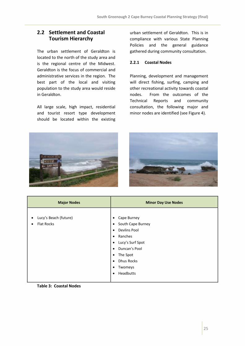
South Greenough 2 Cape Burney Coastal Planning Strategy (final)
25
2.2 Settlement and Coastal Tourism Hierarchy
The urban settlement of Geraldton is
located to the north of the study area and
is the regional centre of the Midwest.
Geraldton is the focus of commercial and
administrative services in the region. The
best part of the local and visiting
population to the study area would reside
in Geraldton.
All large scale, high impact, residential
and tourist resort type development
should be located within the existing
urban settlement of Geraldton. This is in
compliance with various State Planning
Policies and the general guidance
gathered during community consultation.
2.2.1 Coastal Nodes
Planning, development and management
will direct fishing, surfing, camping and
other recreational activity towards coastal
nodes. From the outcomes of the
Technical Reports and community
consultation, the following major and
minor nodes are identified (see Figure 4).
Major Nodes Minor Day Use Nodes
Lucy’sBeach (future)
Flat Rocks
Cape Burney
South Cape Burney
Devlins Pool
Ranches
Lucy’s Surf Spot
Duncan’s Pool
TheSpot
DhusRocks
Twomeys
Headbutts
Table 3: Coastal Nodes

South Greenough 2 Cape Burney Coastal Planning Strategy (final)
26
2.2.3 Major Nodes
Major nodes should continue to be
managed and upgraded to ensure a high
level of facilities such as designated 2WD
vehicle access, car parking areas, ablution
facilities, shelters, precincts to demarcate
and separate competing users,
information and signage, walk trails and
designated off-road entry points.
The major nodes of Lucy’s Beach and Flat
Rocks provide formal access to the coast.
Flat Rocks has a car park, ablution blocks
and a viewing platform for use during surf
events. There are no facilities at Lucy’s
Beach.
Due to the existing level of services and
infrastructure, overnight accommodation
of a low to medium scale could potentially
be developed in the immediate Flat Rocks
vicinity (subject to further detailed
structure planning). The areas around
Lucy’s Beach are not considered suitable
for overnight accommodation due to
primarily geomorphological and visual
landscape constraints.
Lucy’s Beach is presently located on
Reserve 37333 which has the vested
purpose of ‘Rifle Range’. The Geraldton
Greenough Rifle Club is located
immediately to the north-east and there
is a need to protect the ‘Shooting Safety
Template’. Therefore, any land uses
and/or development must not adversely
affect the Rifle Club’s ability to operate.
2.2.4 Minor Day Use Nodes
Minor day use nodes should provide for a
lower level of facilities and access such as
4WD access through dedicated tracks or
rationalised beach access. In some
locations, low-scale parking, ablutions,
shelters and other low-scale tourism
orientated infrastructure may be
appropriate.
Currently, in many locations, informal
access to the beach is through private
property. Management of these access
tracks should be considered part of any
development applications.
2.2.5 Access
Provision of formal access to the coast will
assist in reducing indiscriminate, illegal
access and associated environmental
degradation and management
implications. Barriers should be placed to
restrict access north or south of the
coastal nodes to prevent vegetation
damage and erosion.
It is envisaged that additional coastal
access locations may be appropriate as
part of low impact rural tourism proposals
in appropriately located sites that satisfy
setback requirements for physical
processes, protection of environmental
values and other land use, development
and subdivision criteria referred to in
Section 2.3.
The exact location of coastal access will be
determined on the provision of a site plan
that discusses the existing location of
informal access tracks, beach and dune
conditions, proposed strategies for the
protection of the environment and visual
landscape considerations.

South Greenough 2 Cape Burney Coastal Planning Strategy (final)
27
The provision of public coastal access in
the identified coastal nodes locations may
be facilitated through subdivision. It is
also likely that a more substantial
foreshore reserve will be required to
accommodate any infrastructure or
amenity to accompany the access point
and parking (if provided).
Proponents of development at these
locations will be expected to provide the
vehicle access and associated
infrastructure (including, but not limited
to car parking and vehicle management
infrastructure, fencing and signage) all in
accordance with an approved coastal
management plan or the like.
2.3 Land Use, Development and Subdivision Guidelines
2.3.1 Planning Precincts
The subdivision and development
guidelines are separated into two
planning precincts (the Dune System and
the Coastal Plain) based on the two
dominant landscape features guided by
soil mapping produced by the Department
of Agriculture and Food. The use of
cadastral lines as the basis for applying
different criteria would not take into
account any aspects of the land such as
topography, soil type or vegetation.
The result is that some landholdings
traverse both planning precinct areas.
Therefore, it is intended that the planning
precinct boundaries of the Dune System
and the Coastal Plain be flexible to allow
for consideration of the merits of an
application rather than being a hard line
of separation.
Discretion may be applied to land
traversed or adjacent to these boundaries
where assessment and determination can
be guided by the vision and objectives of
the Strategy. For landholdings that are
clearly contained within a single planning
precinct, subdivision will only be
supported in accordance with the relevant
criteria for either the Dune System or the
Coastal Plain.

South Greenough 2 Cape Burney Coastal Planning Strategy (final)
28
2.3.2 Dune System
The Dune System comprise three basic
elements: a sandy coastline with a
relatively narrow beach, occasional
shoreline reefs and rock platforms; a
vegetated dune system with north-south
trending ridges, swales and blowouts,
with several plateau-like areas that
extend the width of the Dune System in
these locations; and a distinctive,
continuous, scarp-like dune face that
produces an undulating skyline as viewed
from locations to the east. The Dune
System predominantly comprises native
vegetation, although grazing has reduced
the natural species diversity and has
introduced weeds.
2.3.3 Dune System Land Use
Guidelines
The following uses are considered
appropriate subject to compliance with
the relevant Local Planning Scheme,
Council and WA Planning Commission
policies:
Conservation
Heritage Protection/Conservation
Industry Cottage
Low Impact Rural Tourism
Medium-Scale Tourism (at Flat Rocks)
Recreation
Recreation Private
Rural Smallholdings (at Flat Rocks)
Aquaculture (at Twomeys)
2.3.4 Dune System Development
Guidelines
a) All development is to be either
contained within a building
envelope or not be located in a
building exclusion area. A building
envelope is to be shown where the
amount of remnant vegetation or
areas of instability restrict the
location of development. Whereas
a building exclusion area is to be
used when a lot has some areas of
remnant vegetation that should be
protected or areas of instability that
should be avoided and the
remaining land is unencumbered in
terms of development location.
b) Building envelopes should be
located in cleared, stable areas so
as to maximise remnant vegetation
preservation.
c) A building envelope should be a
maximum of 2,000m2. Larger
envelopes may be permitted to
accommodate an existing dwelling
and outbuilding(s) and alternatively
smaller envelopes may be required
in order to minimise clearing of
remnant vegetation.
d) Building mass and scale should be
reduced by developing a number of
smaller buildings. Outbuildings
should be clustered and form a
unified group with the main
building. Colours should be chosen
from the colour swatches in the
Visual Landscape Assessment
Technical Report.

South Greenough 2 Cape Burney Coastal Planning Strategy (final)
29
e) Development should be located at
the base of the dunes and not be
visible on the dune face (from the
Brand Highway/Company Road)
and no built from should be visible
above the dune skyline from Brand
Highway/Company Road or the
coastline (except at identified
medium-scale tourism locations).
f) Development should not detract
from the identified key views in the
Visual Landscape Assessment
Technical Report. Development
should also ensure that natural
elements retain their dominance in
the landscape through the height of
built form.
g) Buildings sited at high points on the
dunes which interrupt the
continuous natural dune skyline are
discouraged. Where elevation is up
to 20m building height should not
exceed 25m AHD. Where the
elevation is above 20m AHD, ensure
that at least half of the dune face is
visible above the built form. The
aim is to ensure the variable height
of the dune face is the dominant
visual feature.
h) Cut and fill methods which level out
the landform are discouraged.
Instead the natural contours of the
land should be retained so
development sits within the
landscape. Roof pitch should align
with the natural slope.
i) Vegetation should be retained on
the dune ridgeline and skyline.
Development should have
vegetation (preferably native)
screening and/or be nestled into
the existing vegetation and into the
folds of the landform.
j) Roads and access tacks should be
designed to provide view corridors
with ocean and coastal plain
glimpses. They should follow the
contours of the landform and be
sited in the swales (not run directly
over high points or ridgelines).
Development should utilise existing
accesses and rationalize
unnecessary accesses (including
access to the coast).
k) All fencing should be of an open
and rural nature.

South Greenough 2 Cape Burney Coastal Planning Strategy (final)
30
2.3.5 Dune System Subdivision
Guidelines
The City MAY support subdivision in the
following circumstances (subject to WA
Planning Commission policy):
a) A foreshore reserve (where
applicable) should be created with
all subdivision and/or
amalgamation proposals.
b) Boundary relocations where no
additional lots are created.
c) Heritage places where subdivision
can be shown as a mechanism to
secure its conservation.
d) Conservation purposes where the
lots proposed are not less than
20ha minimum and 40ha average,
PROVIDED a conservation covenant
in perpetuity with an authority
acceptable to the WAPC is
registered on the certificate of title
for newly created lots. The
restrictive covenant will protect and
preserve remnant or regenerated
vegetation in perpetuity and should
include among other things,
provisions for:
• Prohibit further clearing;
• Clearly delineate a building
envelope and/or building
exclusion area also shown on
the subdivision plan;
• On-going weed management;
• Prohibit stocking;
• Rationalize existing accesses;
• Rehabilitate
unstable/degraded areas with
local provenance seedlings;
and
• Coastal management.
e) An established project of tourist or
recreational significance (at the
coastal nodes).
f) Rural Smallholdings at Flat Rocks
where the lots proposed are not
less than 4ha, subject to detailed
structure planning, land
capability/suitability and
appropriate rezoning.

South Greenough 2 Cape Burney Coastal Planning Strategy (final)
31
2.3.6 Coastal Plain
Within the study area the Coastal Plain is
bounded by the study area boundary on
its east (comprising the Brand Highway,
Company Road and the Greenough River)
and the dune system to the west,
although the unit actually itself extends
further inland and extends into a low
limestone ridge that separates the area
commonly known as the 'Front Flats'
along the Greenough River from the 'Back
Flats'. This area is dominated by
floodplains featuring alluvial soils which
has some of the more significant
horticultural activity and some of the
most productive broadacre land in the
district.
2.3.7 Coastal Plain Land Use Guidelines
The following uses are considered
appropriate subject to compliance with
the relevant Local Planning Scheme,
Council and WA Planning Commission
policies:
• Agriculture Extensive
• Agriculture Intensive
• Conservation
• Heritage Protection/Conservation
• Industry Cottage
• Industry Rural
• Low Impact Rural Tourism
• Recreation
• Recreation Private
• Rural Pursuit
2.3.8 Coastal Plain Development
Guidelines
a) Building mass and scale should be
reduced by developing a number of
smaller buildings. Outbuildings
should be clustered and form a
unified group with the main
building. Colours should be chosen
from the colour swatches in the
Visual Landscape Assessment
Technical Report.
b) Development should not detract
from the identified key views in the
Visual Landscape Assessment
Technical Report. Development
should also ensure that natural
elements retain their dominance in
the landscape through the height of
built form.
c) Buildings sited at high points on the
dunes which interrupt the
continuous natural dune skyline are
discouraged. Where elevation is up
to 20m building height should not
exceed 25m AHD. Where the
elevation is above 20m AHD, ensure
that at least half of the dune face is
visible above the built form. The
aim is to ensure the variable height
of the dune face is the dominant
visual feature.
d) Cut and fill methods which level out
the landform are discouraged
(unless required to establish
minimum floor levels in the flood
plain areas). Instead the natural
contours of the land should be
retained so development sits within
the landscape. Roof pitch should
align with the natural slope.

South Greenough 2 Cape Burney Coastal Planning Strategy (final)
32
e) Vegetation should be retained.
f) Roads and access tacks should be
designed to provide view corridors
with coastal plain glimpses. They
should follow the contours of the
landform and be sited in the swales
(not run directly over high points or
ridgelines). Development should
utilise existing accesses and
rationalize unnecessary accesses
(including access to the coast).
g) All fencing should be of an open
and rural nature.
2.3.9 Coastal Plain Subdivision
Guidelines
Council MAY support subdivision in the
following circumstances (subject to WA
Planning Commission policy):
a) Boundary relocations where no
additional lots are created.
b) Heritage places where subdivision
can be shown as a mechanism to
secure its conservation.
c) Excisions of an established and
sustainable rural industry and/or
rural pursuit (e.g. vineyard, olive
grove, grain storage facility)
PROVIDED the balance of the land
is not less than 40ha.
d) Continued extensive agriculture
where the lots proposed are not
less than 250ha;
e) Demonstrated long-term
sustainable intensive agriculture
where the lots proposed are not
less than 10ha AND the land is
connected to a reticulated water
supply.

South Greenough 2 Cape Burney Coastal Planning Strategy (final)
33
2.3.10 Planning Approval
The planning approval of the local
government is required for all
development in both the Dunes System
and the Coastal Plain planning precincts.
Applications should identify relevant
measures and actions that will meet the
objectives of the Strategy and ensure
each development contributes to the local
vision. Applications should also address
each relevant key objective and provide
information and actions that will be taken
to achieve the objectives.
Land Use e.g. Vegetation condition,
land capability, weed management,
conservation covenants.
Built Environment e.g. Building
Envelopes/Building Exclusion Areas,
location of fences and accessways.
Heritage e.g. Aboriginal or
European Heritage, geoheritage.
Visual Landscape e.g. Siting, height,
form and materials of buildings,
fencing and roads to maintain visual
amenity.
Coastal Geomorphology e.g.
Coastal stability, coastal setback
and foreshore reserves.
Agriculture e.g. Proposed areas for
stocking, irrigation.
Fire Management e.g. Bushfire
hazard assessment and fire
management plans.
Water and Waste Management
e.g. Water sensitive urban design
and local water management
strategies.
Tourism and Recreation e.g. Access
plan, coastal node infrastructure
and management.
2.3.11 Revegetation Guidelines
For land within the Dunes System
planning precinct there is the opportunity
for revegetation and rehabilitation
(utilising local indigenous species) to:
Rehabilitate and expand existing
areas of regionally significant
vegetation;
Rehabilitate and regenerate areas
of degraded vegetation;
Add to the high social and
ecological values of the landscape;
Establish ecological linkages across
the area;
Create habitat for native fauna; and
Increase the quality of vegetation.
As a condition of subdivision, the local
government will require revegetation or
regeneration measures as follows:
In areas that are mapped as having
‘good’, ‘very good’ or ‘excellent’
vegetation condition in the Coastal
Vegetation Survey Technical Report
(see Appendix E), a minimum of 1%
of the lot area revegetated with a
combination of trees, shrubs and
ground covers consistent with the
indigenous plant communities of
the locale. This is in addition to
existing vegetation;

South Greenough 2 Cape Burney Coastal Planning Strategy (final)
34
In areas that are mapped as having
‘degraded’ or ‘completely
degraded’ vegetation condition in
the Coastal Vegetation Survey
Technical Report (see Appendix E),
a minimum of 2% of the lot area
revegetated with a combination of
trees, shrubs and ground covers
consistent with the indigenous
plant communities of the locale.
This is in addition to existing
vegetation; and
In all other areas, a minimum of 3%
of the lot area revegetated with a
combination of trees, shrubs and
ground covers consistent with the
indigenous plant communities of
the locale. This is in addition to
existing vegetation.
In some areas, the intended biodiversity
outcomes may be better achieved
through weed management and
regeneration, or planting other forms of
vegetation (shrubs or groundcovers)
consistent with the indigenous plant
communities of the locale.
Revegetation and rehabilitation should be
prioritised in locations within the lot:
To establish linkages with
neighbouring areas of remnant
vegetation, or a buffer around the
perimeter of remnant vegetation;
To regenerate or rehabilitate
degraded vegetation to a higher
quality; or
To provide screening of development.
2.3.12 Cash-in-Lieu of Revegetation
It is acknowledged that there may be
landowners more committed, skilled and
resourced to undertake revegetation and
rehabilitation and management. There
also may be instances where more
positive biodiversity outcomes can be
achieved through revegetation and
rehabilitation of selective areas.
In these instances and where landholders
may not have the skills, resources, etc. to
carry out revegetation the City may
accept a cash contribution in lieu of
revegetation. The Local Government
Biodiversity Guidelines for the Perth
Metropolitan Region (June 2004) provide
estimates of the costs associated with
undertaking certain management
activities. To reconstruct, ‘upland’ areas
(including weed control, seedling
establishment, plant guards, watering in
and replacement plantings) over a 5 year
period is estimated to cost $10.50/m2.
This is the figure used for calculating the
cash-in-lieu contribution and may be
revised from time to time by the City.
Monies collected will be held in trust for
use in achieving biodiversity outcomes
within the study area.

South Greenough 2 Cape Burney Coastal Planning Strategy (final)
35
3 PART III: MANAGEMENT 3.1 Management Goals The overarching management goals for
the study area are:
To ensure the preservation of key
environmental attributes and
ecosystem functions;
To provide, and encourage the use
of, recreational facilities at key
coastal nodes;
To reduce areas of degradation
caused by recreational use; and
To ensure a consistent and joint
approach to the protection and
restoration of the coastal
environment.
3.2 Management Recommendations
This management section aims to increase
knowledge and awareness on current and
potential land management issues
impacting on the natural resources. It
also encourages a more consistent use of
best practice management techniques in
order to minimise the impacts associated
with the increasing development and
recreational pressures.
3.2.1 Land Use
Protect and rehabilitate foredune
and primary dune vegetation
through activities such as track
rationalisation, track maintenance,
planting native species, weeds
removal, dune matting, fencing,
bollards and directional signage.
Monitor changes in the distribution,
abundance and impact of invasive
species to ensure management
practices are adapted to minimise
current/future impacts on local
biodiversity.
Prepare site-specific management
plans for day use nodes to manage
competing uses.
Undertake on-going monitoring of
the use of both formal and informal
beach access tracks.
Close informal tracks close to the
beach and parallel with the shore
and rehabilitate adjacent degraded
areas.
Identify accesses to beaches that
are linked to sections of the coast
stabilised by rock outcrops. Once
identified, these tracks should then
be fenced to protect the dunes and
surrounding vegetation and vested
in the council for maintenance.
Rehabilitate all other tracks through
private property.
Private landowners to prepare
coastal management plans that
identify mitigation strategies for the
protection and rehabilitation of
coastal areas.
Flood mitigation structures (particularly levee banks) should receive ongoing maintenance to protect agricultural crops, land and infrastructure from fold damage.
Provide signage containing information on access and appropriate usage of the area.

South Greenough 2 Cape Burney Coastal Planning Strategy (final)
36
3.2.2 Built Environment
Materials used should be consistent
with and enhance or reflect the
local character.
Avoid the use of highly reflective or
brightly coloured building materials
that contrast with the surrounding
landscape.
Site buildings at low points of the
dunes so that they do not interrupt
the continuous nature of the dune
skyline.
Utlise vegetation screening
(preferably with local provenance
species).
Built from should respond to the
natural topography.
3.2.3 Heritage
Minimise site disturbance and
impact on heritage sites and
provide interpretive signage where
appropriate.
Do not attempt to mimic heritage
character but rather use
contemporary design elements.
3.2.4 Visual Landscape
Undertake on-going maintenance
of existing facilities at day use
nodes; consider the provision of
new recreational facilities where
needed. The character of the
landscape should be reflected and
maintained in any development.
New roads, firebreaks, access tracks
and other linear features should
follow the contour of the landform
and not be oriented towards the
key view-sheds.
Retain natural character where it
currently exists and reduce visibility
and potential visibility of
recreation, tourism or other
development nodes by containing
their visibility to within their
immediate view-shed and by
retaining or re-introducing local
native vegetation.
3.2.5 Coastal Geomorphology
Establish and/or realign access
tracks preferable through stable
dunes perched on coastal
limestone.
Restrict coastal access and
recreational activities in proximity
to active blowouts.
Erect signage to raise awareness of
degradation issues and inform
users about appropriate use of day
use nodes.

South Greenough 2 Cape Burney Coastal Planning Strategy (final)
37
3.2.6 Fire Management
Develop site planning for day use
nodes that consider opportunities
for site layout and design to
minimise fire events and their
impacts.
Undertake ongoing maintenance
works for facilities and
infrastructure installed at day use
nodes (these may include frequent
rubbish removal, fencing around
brushed areas, not brushing
adjacent to access ways, and the
installation of gas rather than wood
barbeques).
Provide adequate buffers between
coastal reserves and built structures
that are at risk of fire damage.
Improve community awareness
through signage about potential
sources of ignition, such as
motorbikes in dry vegetation, and
inappropriate activities, such as
illegal campfires, and burning
without a permit.
3.2.7 Water and Wastewater
Management
Plant local indigenous native
species.
Minimise the need for drainage
outfalls to the coast and ensuring
that the location and design of all
structures minimises the impact on
both physical and ecological
processes and coastal amenity.
Protect and enhance
environmental, recreational and
cultural values of natural water
systems and their hydrological
regimes.
Manage contamination risks to
groundwater from unsuitable
approaches to wastewater disposal.
3.2.8 Tourism and Recreation
Undertake on-going management and
maintenance of major nodes to
ensure a high level of facilities.
Undertake on-going maintenance of
access tracks to minor day use sites.
Encourage users of the coast to use
only designated off-road vehicle
tracks in areas where they exist and
discourage from accessing the coast
where tracks have not been
formalized and there are signs of
erosion.

South Greenough 2 Cape Burney Coastal Planning Strategy (final)
38
4 GLOSSARY OF TERMS
Agriculture Extensive means premises used for the raising of stock or crops but does not
include agriculture intensive or feedlots.
Agriculture Intensive means premises used for trade or commercial purposes, including
outbuildings and earthworks, associated with the following:
(a) the production of grapes, vegetables, flowers, exotic or native plants, or fruit or nuts;
(b) the establishment and operation of plant or fruit nurseries;
(c) the development of land for irrigated fodder production or irrigated pasture (including
turf farms); or
(d) aquaculture.
Biodiversity means ‘The variety of life forms – the different plants, animals and micro-
organisms, the genes they contain, and the ecosystems they form’, National Strategy for the
Conservation of Australia’s Biological Diversity (2010). In this case, the aim is to conserve
the variety of species and vegetation communities in the area.
Coastal Compartment means the length of shoreline bounded by broad scale changes in
geology, geomorphic structures/landforms or changes in the aspect of the shore.
Coastal or Foreshore Management Plan means a local scale plan designating areas for
various purposes such as public access, car parks, toilets and providing advice on
management needs. Foreshore management plans tend to deal with a smaller area, are
more detailed and prepared as part of a planning approval process, ongoing maintenance or
upgrading program.
Coastal Susceptibility means the susceptibility of the coast to change in the frequency and
intensity of metocean processes according to the geological structure, regional to sub-
regional scale landforms and landform patterns of discrete sections of the coast.
Conservation means the careful management of the natural resources and environment so
to avoid, or at the very least, minimise change.
Day Use Site means sites that are generally associated with a feature, activity or
interpretation focus, suited to short stays. The area is designated and managed to provide
visitor amenities for day use only. It may include parking facilities, shade shelters,
barbecues, toilets and picnic areas but does not cater for, or permit, overnight stays.
Ecological Linkages means connected areas of ecosystems (e.g. bushland) that enable
movement of animals, exchange of genetic material between plants and ensure ecosystems
are more resilient in the face of change.

South Greenough 2 Cape Burney Coastal Planning Strategy (final)
39
Heritage Protection/Conservation means, in relation to any place, the management of that
place in a manner that will:
(a) enable the cultural heritage significance of that place to be retained; and
(b) yield the greatest sustainable benefit for the present community without diminishing
the cultural heritage significance of that place,
and may include the preservation, stabilization, protection, restoration, reconstruction,
adaptation, and maintenance of that place in accordance with relevant professional
standards, and the provision of an appropriate visual setting.
Hobby Farm means the partial or entire use of a small landholding for rural activities that
provide and agricultural interest and or/additional income for the owner of the land.
Industry Cottage means a trade or light industry producing arts and crafts goods which does
not fall within the definition of a home occupation and which:
(a) does not cause injury to or adversely affect the amenity of the neighbourhood;
(b) where operated in a residential zone, does not employ any person other than a
member of the occupier’s household;
(c) is conducted in an out-building which is compatible with the principal uses to which
land in the zone in which it is located may be put;
(d) does not occupy an area in excess of 50m²; and
(e) does not display a sign exceeding 0.2m² in area.
Industry Rural means:
(a) an industry handling, treating, processing or packing rural products; or
(b) a workshop servicing plant or equipment used for rural purposes.
Low Impact Rural Tourism means the use and development of land, principally for tourist
purposes, in such a manner that does not detract from the rural and natural amenity of the
locality, and includes the following criteria:
(a) located to avoid ridge lines, escarpments or visually exposed sites and situated where
vegetation or land form can be utilised for screening;
(b) sensitively located and designed to promote positive outcomes and positive
environmental outcomes and minimise impact on vegetation, water courses, soil
quality and existing land uses;
(c) will not cause a net loss of vegetation;
(d) scale and nature to be self sustaining on the land, or demonstrate the ability to
provide servicing without significant modifications to existing infrastructure;
(e) the nature of its scale, design, colours, materials, landscaping and use has minimal
visual impact on the site and surrounding areas; and
(f) minimal off-site environmental or social adverse impacts.

South Greenough 2 Cape Burney Coastal Planning Strategy (final)
40
The maximum scale of development is restricted to no more than 3 chalets/cabins or a bed
& breakfast facility or a 4 bedroom guest house which accommodates no more than 8
people (or other tourist facilities of similar land use intensity).
Medium-Scale Tourism means a range of tourist uses/development consistent with the rural
ethos of the locality (e.g. café, caravan park, eco resort). Depending on the nature of the
development it may require rezoning.
Recreation means the use of land for leisure purposes (e.g. fishing, swimming, bush walking,
surfing).
Recreation Private means premises used for indoor or outdoor leisure which are not usually
open to the public without charge and are complimentary to the rural ethos of the locality
(e.g. guided walks, fishing tours, wildlife park).
Regeneration means the restoration of natural ecosystems through cyclic processes of
renewal and self maintenance of species and their populations. Emphasis is more on
removing threats (such as weeds and rabbits) than intensive revegetation.
Rehabilitation means to restore elements of ecological structure or function without
necessarily attempting complete restoration to any specific prior condition.
Revegetation means establishment of native vegetation to a minimum standard in formerly
cleared areas (that may be part of a rehabilitation or complete restoration).
Rural Pursuit means any premises used for:
(a) the rearing or agistment of animals;
(b) the stabling, agistment or training of horses;
(c) the growing of trees, plants, shrubs or flowers for replanting in domestic, commercial
or industrial gardens; or
(d) the sale of produce grown solely on the lot, but does not include agriculture –
extensive or agriculture – intensive.
Rural Smallholdings means land used for minor rural pursuits, hobby farming, conservation
and alternative residential lifestyle purposes. The land use seeks to preserve and enhance
landscape quality, environmental and conservation attributes.
Sediment Cell means a length of shoreline in which interruptions to the movement of
sediment along the beaches or near shore sea bed do not significantly affect beaches in the
adjacent lengths of coastline. Within a sediment cell the sediments sources, transport
pathways and sinks should be clearly definable.
South Greenough 2 Cape Burney Coastal Planning Strategy (final)
41
Sustainability means the ability of our city-region’s environment, social, governance,
economic and cultural systems to maintain their health and resilience in perpetuity.
Sustainable development is ‘development that meets the needs of present generations
without compromising the ability of future generations to meet their own needs’.
Vulnerability means the degree to which a system is susceptible to, or unable to cope with,
adverse effects of climate change, including climate variability and extremes. Vulnerability is
a function of the character, magnitude, and rate of climate change and variation to which a
system is exposed, its sensitivity, and its adaptive capacity. Systems that are highly exposed,
sensitive and less able to adapt are vulnerable.

South Greenough 2 Cape Burney Coastal Planning Strategy (final)
FIGURES
Figure 1 – Study Area
Figure 2 – Landscape Features
Figure 3 – Land Tenure
Figure 4 – Coastal Nodes
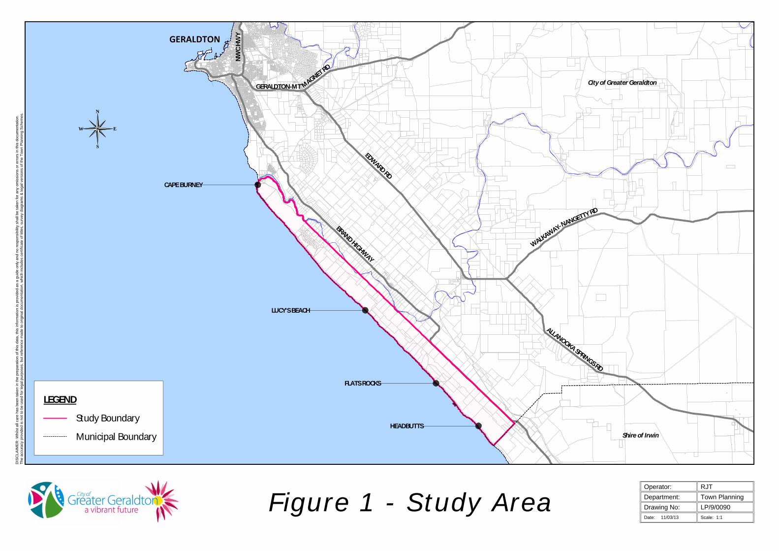
DIS
CLA
IME
R: W
hils
t all
care
has
bee
n ta
ken
in th
e pr
epar
atio
n of
this
dat
a, th
is in
form
atio
n is
pro
vide
d as
a g
uide
onl
y an
d no
resp
onsi
bilit
y sh
all b
e ta
ken
for a
ny o
mis
sion
s or
err
ors
in th
is d
ocum
enta
tion.
The
accu
racy
pro
vide
d is
not
to b
e us
ed fo
r leg
al p
urpo
ses,
but
refe
renc
e m
ade
to o
rigin
al d
ocum
enta
tion,
whi
ch in
clud
es c
ertif
icat
e of
title
s, s
urve
y di
agra
ms
& le
gal v
ersi
ons
of th
e To
wn
Pla
nnin
g S
chem
es.
Date: Scale: 1:1
LP/9/0090
RJTTown PlanningDepartment:
Drawing No:
Operator:
11/03/13
Figure 1 - Study Area
CAPE BURNEY
LUCY'S BEACH
HEADBUTTS
FLATS ROCKS
GERALDTON
Shire of Irwin
City of Greater Geraldton
NW
C HW
Y
GERALDTON-MT MAGNET RD
NANGETTY RD
WALKAWAY-
ALLANOOKA SPRINGS RD
EDWARD RD
BRAND HIGHWAY
Study Boundary
Municipal Boundary
LEGEND
N
S
W E

LP/9/0090
RJTTown PlanningDepartment:
Drawing No:
Operator:
Figure 2 - Landscape Features
ALLANOOKA
SPRINGS RDEDW
ARD RDBRAND HIGHWAY
City of Greater Geraldton
Shire of Irwin
LEGEND
Dune System
Coastal Plain
14/08/12Date: Scale: 1:1
DIS
CLA
IME
R: W
hils
t all
care
has
bee
n ta
ken
in th
e pr
epar
atio
n of
this
dat
a, th
is in
form
atio
n is
pro
vide
d as
a g
uide
onl
y an
d no
resp
onsi
bilit
y sh
all b
e ta
ken
for a
ny o
mis
sion
s or
err
ors
in th
is d
ocum
enta
tion.
The
accu
racy
pro
vide
d is
not
to b
e us
ed fo
r leg
al p
urpo
ses,
but
refe
renc
e m
ade
to o
rigin
al d
ocum
enta
tion,
whi
ch in
clud
es c
ertif
icat
e of
title
s, s
urve
y di
agra
ms
& le
gal v
ersi
ons
of th
e To
wn
Pla
nnin
g S
chem
es.
N
S
W E

LP/9/0090
RJTTown PlanningDepartment:
Drawing No:
Operator:
Figure 3 - Land Tenure
City of Greater Geraldton
Shire of Irwin
ALLANOOKA
SPRINGS RDEDW
ARD RDBRAND HIGHWAY
LEGEND
Unallocated Crown Land (UCL)
Freehold
Reserve
14/08/12Date: Scale: 1:1
DIS
CLA
IME
R: W
hils
t all
care
has
bee
n ta
ken
in th
e pr
epar
atio
n of
this
dat
a, th
is in
form
atio
n is
pro
vide
d as
a g
uide
onl
y an
d no
resp
onsi
bilit
y sh
all b
e ta
ken
for a
ny o
mis
sion
s or
err
ors
in th
is d
ocum
enta
tion.
The
accu
racy
pro
vide
d is
not
to b
e us
ed fo
r leg
al p
urpo
ses,
but
refe
renc
e m
ade
to o
rigin
al d
ocum
enta
tion,
whi
ch in
clud
es c
ertif
icat
e of
title
s, s
urve
y di
agra
ms
& le
gal v
ersi
ons
of th
e To
wn
Pla
nnin
g S
chem
es.
N
S
W E

DIS
CLA
IME
R: W
hils
t all
care
has
bee
n ta
ken
in th
e pr
epar
atio
n of
this
dat
a, th
is in
form
atio
n is
pro
vide
d as
a g
uide
onl
y an
d no
resp
onsi
bilit
y sh
all b
e ta
ken
for a
ny o
mis
sion
s or
err
ors
in th
is d
ocum
enta
tion.
The
accu
racy
pro
vide
d is
not
to b
e us
ed fo
r leg
al p
urpo
ses,
but
refe
renc
e m
ade
to o
rigin
al d
ocum
enta
tion,
whi
ch in
clud
es c
ertif
icat
e of
title
s, s
urve
y di
agra
ms
& le
gal v
ersi
ons
of th
e To
wn
Pla
nnin
g S
chem
es.
Date: Scale: 1:1
LP/9/0090
RJTTown PlanningDepartment:
Drawing No:
Operator:
23/01/13
Figure 4 - Costal Nodes
RANCHES
HEADBUTTS
THE SPOT
TWOMEYS
LUCYS SURF SPOT
DHUS ROCKS
DUNCANS POOL
FLAT ROCKS
LUCYS BEACH
DEVLINS POOL (BLUE MOONIES)
CAPE BURNEY
ALLANOOKA
SPRINGS RDEDW
ARD RDBRAND HIGHWAY
City of Greater Geraldton
Shire of Irwin
LEGEND
Minor Day Use Nodes
Major Nodes
N
S
W E

South Greenough 2 Cape Burney Coastal Planning Strategy (final)
APPENDICES
Appendix A – Summary of Community Workshop Outcomes & Online Survey Results
Appendix B – Coastal Nodes Site Plans (Lucy’s Beach & Flat Rocks)
Appendix C – Flood Mapping
Appendix D – Tourism WA Visitor Survey
Appendix E – Vegetation Condition Mapping