collector for arcgis: an introduction
DESCRIPTION
Collector for ArcGIS: An Introduction. Paul Barker & Russ Roberts. Topics. Going Mobile ArcGIS as a platform for your Organization What is Collector for ArcGIS Creating a map for data collection What’s next?. Going Mobile. Source: http://www.idc.com/getdoc.jsp?containerId=prUS23946013. - PowerPoint PPT PresentationTRANSCRIPT

Collector for ArcGIS: An Introduction
Paul Barker & Russ Roberts

Topics
• Going Mobile
• ArcGIS as a platform for your Organization
• What is Collector for ArcGIS
• Creating a map for data collection
• What’s next?

Going Mobile
• Source:http://www.idc.com/getdoc.jsp?containerId=prUS23946013
• 722 million smartphones were shipped in 2012
• Becoming pervasive and common place for both the workforce and consumer space
• Unprecedented opportunities

Paul Barker
ArcGIS for Organizations
ArcGIS

• A platform for your organization to…
Ready to use ContentReady to use ContentReady to use AppsReady to use Apps
• with…
ExploreExplore
DiscoverDiscover CollaborateCollaborate
Reach UsersReach Users
AnalyzeAnalyze
ManageManage DevelopDevelop
What is ArcGIS?

What is ArcGIS?
Desktop
Tablets
Smartphones
Websites
ArcGIS Online
Browsers
Social media
• Intelligent maps that can be used anywhere

Paul Barker
What is Collector for ArcGIS?
ArcGIS
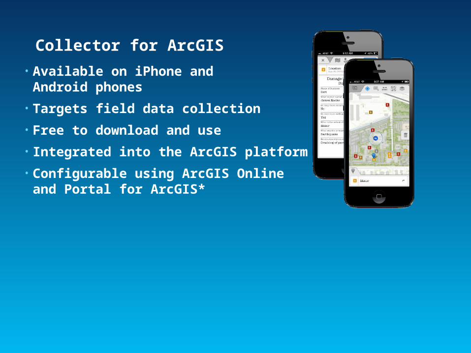
Collector for ArcGIS
• Available on iPhone and Android phones
• Targets field data collection
• Free to download and use
• Integrated into the ArcGIS platform
• Configurable using ArcGIS Onlineand Portal for ArcGIS*

• Logging in (User Identity)- Required for use
- Find maps shared for collection
• Finding your work location- Use GPS to find where you are
- Search Places and Addresses
- Get directions to navigate yourself
• Exploring the map- Tap on the map to learn more
- Measure distances and area
- Manage layers and basemaps
Getting started with Collector
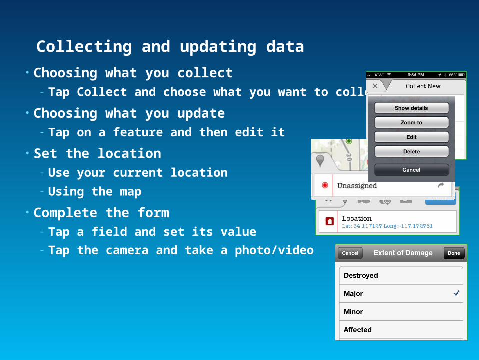
Collecting and updating data
• Choosing what you collect- Tap Collect and choose what you want to collect
• Choosing what you update- Tap on a feature and then edit it
• Set the location- Use your current location
- Using the map
• Complete the form- Tap a field and set its value
- Tap the camera and take a photo/video
Paul Barker
Creating a map for data collection
ArcGIS

Maps for data collection
• A web map:- Point feature service layer (editable)
- Lines and Areas are coming soon.
- Location Tracking layer (optional)
- Application settings
• Share using groups- Create Named Users for each
field worker
- Invite field workers to groups
- Share maps into groups

Feature Services
• Supported Types- ArcGIS Online (Hosted)
- ArcGIS Server (On Premise)
- Must include an editable point layer
• Ways to create one:- Publish from ArcMap (both types)
- Reference from ArcGIS Server
- Create using ArcGIS Online- Create Service
- From existing content (shapefile, CSV)
• Popups and fields- Define the form experience in Collector

Location Tracking Service
• Hosted Feature Serviceonly!
• Create one or more per field team
• Add to web map and configurecapture interval
• Schema automatically captures:- Accuracy – GPS accuracy in meters
- Creator – username for named user account
- Creation Date – Date/Time at point of creation

Publishing Workflows
Hosted Approach using ArcMap (Data Copy)
Web Map GroupCollectors 1, 2, 3
Collector 3
Collector 2
Collector 1
ArcMap HostedFeature Service(s)
--Optional--
Hosted Approach using Shapefiles/CSV (Data Copy)
HostedFeature Service(s)
Web Map GroupCollectors 1, 2, 3
Collector 3
Collector 2
Collector 1
.CSV file/Shapefile

Publishing Workflows
Hybrid Approach (Data Reference)
ArcMap
HostedFeature Service
On-PremiseFeature Service
Web Map Group Collectors 1, 2, 3
Collector 3
Collector 2
Collector 1

Russ Roberts
Pulling it all together
ArcGIS

Paul Barker
What’s next?
ArcGIS

Questions?
ArcGIS
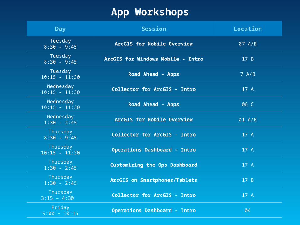
App Workshops
Day Session Location
Tuesday8:30 – 9:45
ArcGIS for Mobile Overview 07 A/B
Tuesday8:30 – 9:45
ArcGIS for Windows Mobile - Intro 17 B
Tuesday10:15 – 11:30
Road Ahead – Apps 7 A/B
Wednesday10:15 – 11:30
Collector for ArcGIS – Intro 17 A
Wednesday10:15 – 11:30
Road Ahead – Apps 06 C
Wednesday1:30 – 2:45
ArcGIS for Mobile Overview 01 A/B
Thursday8:30 – 9:45
Collector for ArcGIS - Intro 17 A
Thursday10:15 – 11:30
Operations Dashboard – Intro 17 A
Thursday1:30 – 2:45
Customizing the Ops Dashboard 17 A
Thursday1:30 – 2:45
ArcGIS on Smartphones/Tablets 17 B
Thursday3:15 – 4:30
Collector for ArcGIS – Intro 17 A
Friday9:00 – 10:15
Operations Dashboard – Intro 04

Developer WorkshopsDay Session Location
Tuesday10:15 – 11:30
Windows Phone – Developing Apps 17 B
Tuesday1:30 – 2:45
Java SE– Developing Apps 17 A
Tuesday1:30 – 2:45
iOS – Developing Apps 17 B
Tuesday3:15 – 4:30
Android - Developing Apps 17 B
Wednesday8:30 – 9:45
Road Ahead – Runtime 07 A/B
Wednesday3:15 – 4:30
OS X – Developing Apps 17 A
Wednesday3:15 – 4:30
Windows Store – Developing Apps 17 B
Thursday10:15 – 11:30
Qt – Developing Apps 32 A
Thursday3:15 – 4:30
Road Ahead –Runtime 06 A
Thursday3:15 – 4:30
WPF – Developing Apps 17 B

Special Meetings
Day Session Location
Wednesday12:00 – 1:00
Mobile SIG 04
Wednesday5:30 – 7:00
ArcPad User Group Meeting 26 B
Esri Product Islands
Day Times Location
Tuesday 9:00 – 6:00 Halls B, C, D
Wednesday 9:00 – 6:00
* Family Night from 4:00 – 6:00Halls B, C, D
Thursday 9:00 – 1:30 Halls B, C, D
Demo Theatre Presentations all day long, every day…
