community planning and development planning …...application of overlay zone districts if both map...
TRANSCRIPT
Community Planning and Development
Planning Services
201 W. Colfax Ave., Dept. 205
Denver, CO 80202
p: 720.865.2915
f: 720.865.3052
www.denvergov.org/CPD
TO: Denver City Council FROM: Abe Barge, Principal City Planner Laura Brudzynski, Manager of Housing Policy and Programs DATE: February 8, 2018 RE: (A) Ordinance for proposed Denver Zoning Code Text Amendment #2 to create the River
North Design Overlay (DO-7) and 38th and Blake Incentive Overlay (IO-1) Zone Districts (CB18-0016) -AND- (B) Ordinance for official Zoning Map Amendment proposal #2017I-00121 to rezone properties with existing mixed-use zoning in the River North and 38th and Blake Station Area to include the DO-7 and IO-1 Overlay Zone Districts (CB18-0017) -AND- (C) Ordinance for proposed Denver Revised Municipal Code Amendment to create a new Chapter 27, Article VI ‘Incentives for Affordable Housing’ establishing affordable housing requirements for the 38th and Blake Incentive Overlay (CB18-0019) -AND- (D) Ordinance establishing a new “Affordable Housing Incentive Fee Fund” (CB18-0014)
Staff Report and Recommendation
A. Denver Zoning Code Text Amendment (CB18-0016)
Based on the review criteria for a text amendment stated in the Denver Zoning Code (DZC), Section 12.4.11 (Text Amendment), Community Planning and Development (CPD) staff recommends approval for Denver Zoning Code Text Amendment #2.
B. Denver Zoning Code Map Amendment (CB18-0017) Based on the review criteria for a map amendment in the Denver Zoning Code (DZC), Section 12.4.10 (Map Amendment), CPD staff recommends approval for map amendment proposal #2017I-00121.
C. Denver Revised Municipal Code Amendment (CB18-0019) Office of Economic Development (OED) and CPD staff recommend approval for the Denver Revised Municipal Code (DRMC) amendment to create a new Chapter 27, Article VI establishing affordable housing requirements for the 38th and Blake Incentive Overlay (IO-1).
D. New “Affordable Housing Incentive Fee Fund” (CB18-0014) Department of Finance – Budget and Management Office (BMO), Office of Economic Development (OED) and CPD staff recommend approval of the proposed “Affordable Housing Incentive Fee Fund.”

Zoning Code Text Amendment #2 for DO-7 and IO-1 Overlay Districts / Map Amendment 2017I-00121 to Apply Overlay Districts / DRMC Amendment to Establish Associated Housing Requirements / Incentive Fund Creation February 8, 2018 Page 2
Summary and Purpose
This staff report summarizes a series of related Denver Zoning Code and Denver Revised Municipal Code (DRMC) amendments, and establishment of a related incentive fee fund, that are proposed to require higher design quality for new development in RiNo and create a system to incentivize provision of affordable housing by allowing increased building height in the 38th and Blake Station area. The amendments directly implement recommendations included in the adopted 2016 38th and Blake Station Area Height Amendments. Because the Denver Zoning Code includes very specific criteria for consideration of code amendments, the majority of this report focuses on the proposed zoning amendments, while noting their relationship with the proposed DRMC amendments and incentive fund that would provide the specific affordable housing and other requirements for use of incentive height enabled by the IO-1 overlay.

Zoning Code Text Amendment #2 for DO-7 and IO-1 Overlay Districts / Map Amendment 2017I-00121 to Apply Overlay Districts / DRMC Amendment to Establish Associated Housing Requirements / Incentive Fund Creation February 8, 2018 Page 3
A. Denver Zoning Code Text Amendment #2 (CB18-0016)
City Council President Albus Brooks is sponsoring a text amendment to the Denver Zoning Code to establish overlay zone districts that implement the specific objectives of the adopted 2016 38th and Blake Station Area Height Amendments. The text amendment would:
1. Establish River North Design Overlay (DO-7): This design overlay district would implement 38th and Blake Station Area Height Amendments objectives for enhanced design quality. It would also accommodate a related request from the River North Art District to establish heightened design standards throughout the River North Business Improvement District. The River North Design Overlay would apply only to underlying mixed-use zone districts (C-MX, I-MX, etc.)
2. Establish a New Category of Overlay: The new ‘Incentive Overlay District’ category of overlay zone district would enable adjustment of zoning code standards to incentivize specific development outcomes such as increased affordable housing, publicly-accessible open space or other outcomes consistent with adopted policy objectives.
3. Establish the 38th and Blake Incentive Overlay (IO-1): The first incentive overlay district would implement specific 38th and Blake Station Area Height Amendment objectives by enabling increased height for projects that provide specific community benefits, including affordable housing. The 38th and Blake Incentive Overlay District would apply only to underlying mixed-use zone districts (C-MX, I-MX, etc.). Note that specific affordable housing, fee and other requirements are addressed in a related DRMC amendment (see C. below).
Relationship of Denver Zoning Code Text and Map Amendments Two map amendments are proposed to rezone properties for use of the DO-7 and IO-1 overlays. Map amendment 2017I-00121 (addressed in this staff report – see B. below) would rezone existing mixed-use properties to include the overlays. Map amendment proposal 2017I-00122 (addressed in a separate staff report – will be considered for adoption subsequent to map amendment proposal 2017I-00121) would rezone some properties to appropriate mixed-use districts and apply the overlays. The map on the next page summarizes application of the DO-7 and IO-1 overlays if both map amendments are adopted. Properties within the intended overlay boundaries that are not proposed for initial overlay application include properties with custom zoning or where property owners have elected to maintain existing industrial zoning. Such properties may submit future map amendment applications to rezone to a mixed-use district that enables overlay application.

Zoning Code Text Amendment #2 for DO-7 and IO-1 Overlay Districts / Map Amendment 2017I-00121 to Apply Overlay Districts / DRMC Amendment to Establish Associated Housing Requirements / Incentive Fund Creation February 8, 2018 Page 4
Application of overlay zone districts if both map amendment 2017I-00121 (addressed in this staff report) and
2017I-00122 (separate staff report) are adopted.

Zoning Code Text Amendment #2 for DO-7 and IO-1 Overlay Districts / Map Amendment 2017I-00121 to Apply Overlay Districts / DRMC Amendment to Establish Associated Housing Requirements / Incentive Fund Creation February 8, 2018 Page 5
B. Denver Zoning Code Map Amendment #2017I-00121 (CB18-0017)
City Council President Albus Brooks is also sponsoring a map amendment to rezone properties within existing mixed-use zone districts (C-MX and I-MX) to include the proposed DO-7 and IO-1 overlay districts (38th and Blake Station Area) or DO-7 overlay district in the remaining portion of the River North Business Improvement District south of the station area. If the new overlay zone districts are approved, all zoning standards that are not specifically addressed by the overlay districts will remain in effect, including the existing Billboard Use Overlay (UO-2).
Properties with existing mixed-use zoning that are included in proposed map amendment 2017I-00121
DO-7 & IO-1 Overlays
DO-7 Overlay

Zoning Code Text Amendment #2 for DO-7 and IO-1 Overlay Districts / Map Amendment 2017I-00121 to Apply Overlay Districts / DRMC Amendment to Establish Associated Housing Requirements / Incentive Fund Creation February 8, 2018 Page 6
The table below provides additional details related to the map amendment request:
Council District: Council District 9 Neighborhoods: Globeville, Cole, Elyria and Swansea, Five Points RNOs: Inter-Neighborhood Cooperation (INC), RiNo, River North Art District, United
Community Action Network Inc., Curtis Park Neighbors, Globeville Civic Association #2, Globeville Civic Partners, The Points Historical Redevelopment Corp, Five Points Business District, Rail Yard Lofts Homeowner’s Association, Inc., Denver Neighborhood Association, Inc., Cross Community Coalition, Elyria and Swansea Neighborhood Association, Elyria Swansea/Globeville Business Association, Opportunity Corridor Coalition of United Residents, Globeville K.A.R.E.S., Rio Norte, Cole Neighborhood Association, Denver Arts and Culture Initiative, Comunidades Unidades Globeville Elyria & Swansea, North Neighborhoods Democratic Council, Ballpark Collective, Blake27 Urban Brownstones
Area: Approximately 250 acres Current Zoning: Multiple C-MX and I-MX zone districts, some with the Adult Use Overlay (UO-1)
and/or Billboard Use Overlay (UO-2) Proposed Zoning: Application of the DO-7 (River North Design Overlay) and IO-1 (38th and Blake
Incentive Overlay) with preservation of the existing Adult Use Overlay (UO-1) and/or Billboard Use Overlay (UO-2) where applicable
C. Denver Revised Municipal Code Amendment to Establish Affordable Housing Requirements Linked to DZC 38th and Blake Station Area Incentive Overlay (CB18-0019) City Council President Albus Brooks is also sponsoring a related amendment to the Denver Revised Municipal Code (DRMC) to establish a new Chapter 27, Article VI ‘Incentives for Affordable Housing.’ The proposed article provides a framework for requirements related to regulatory or other systems to incentivize the construction of additional affordable housing beyond existing requirements. The proposed amendment is focused on affordable housing and related requirements associated with height incentives in the proposed DZC IO-1 38th and Blake Incentive Overlay (see B. above). However, future amendments to the proposed DRMC Chapter 27, Article VI could accommodate future DZC incentive overlay districts or other mechanisms to incentivize affordable housing citywide or in specific areas.

Zoning Code Text Amendment #2 for DO-7 and IO-1 Overlay Districts / Map Amendment 2017I-00121 to Apply Overlay Districts / DRMC Amendment to Establish Associated Housing Requirements / Incentive Fund Creation February 8, 2018 Page 7
Affordable housing, fee and related requirements for projects using incentive height in the proposed DZC UO-1 38th and Blake Incentive Overlay would vary by land use:
• Primarily Residential Projects (50%+ residential floor area). o Must build affordable residential units on-site or in the overlay area – no option to
pay linkage or incentive fees. o The number of affordable residential units required includes the total of:
▪ Units required using the ‘build alternative’ formula set forth for the citywide linkage fee as applied to all project square footage
▪ Four times the units required using the ‘build alternative’ formula set forth for the citywide linkage fee as applied to project square footage located above the base height allowed by the underlying zone district, up to the maximum incentive height allowed by the IO-1 overlay
• Primarily Non-Residential Projects (<50% residential floor area) o Option 1: Build affordable residential units on site or in the overlay area according
to the formulas described above for residential projects o Option 2: Pay a fee that is the sum total of:
▪ The existing citywide linkage fee as applied to all project square footage ▪ An incentive fee that is four times the citywide linkage fee as applied to
project square footage located above the base height allowed by the underlying zone district, up to the maximum incentive height allowed by the IO-1 overlay
o Option 3: Pay the existing citywide linkage fee as applied to all project square footage and execute a community benefits agreement to provide affordable space to community-serving uses (artist studios, non-profits, etc.) rather than paying the incentive fee that would otherwise apply to project square footage located above the base height
The 38th and Blake Incentive Overlay Summary handout provided in Attachment E provides more information on specific inventive requirements and illustrates several sample project scenarios using incentive height.
Zoning Code Text Amendment #2 for DO-7 and IO-1 Overlay Districts / Map Amendment 2017I-00121 to Apply Overlay Districts / DRMC Amendment to Establish Associated Housing Requirements / Incentive Fund Creation February 8, 2018 Page 8
For policy consistency and administrative efficiency, affordable housing requirements within the proposed DRMC Chapter 27, Article VI extensively cross-reference existing affordable housing requirements. Many cross-references create links between proposed Article VI and recently-adopted Article V ‘Dedicated Funding for Affordable Housing’ to relate proposed incentive requirements to formulas and procedures related to Denver’s new Affordable Housing Linkage Fee. Key relationships between the existing DRMC Chapter 27 Article V and the proposed Article VI include:
• Affordable housing unit and fee formulas that are tied to citywide linkage fee formulas o Incentive formulas require multiples of existing citywide formulas to clearly
establish that additional affordable units or fees are required when using incentives. o Any future revisions to citywide formulas (including income thresholds or changes
related to the consumer price index) will automatically apply to incentive formulas.
• Affordable housing unit location, size and term requirements that are tied to requirements for units provided through the citywide linkage fee ‘build alternative’ or related administrative rules and regulations.
o Affordable housing provided to meet citywide or incentive requirements must be comparable in mix and size to the market rate units that generated the requirement (i.e, if market rate units are one and two bedrooms, cannot be studios or micro units).
o Affordable housing provided to meet citywide or incentive requirements must be located on site or near the market rate units that generated the requirement (units required for incentive height in the IO-1 overlay must be provided within the overlay, which covers the area near the 38th and Blake commuter rail station).
o Specific financial arrangements are required to ensure that off-site units promised to meet citywide or incentive requirements are actually delivered.
Any future revisions to citywide affordable housing procedures (including terms for restriction on affordability) will apply to affordable housing incentives.
D. New “Affordable Housing Incentive Fee Fund” (CB18-0014)
Finally, City Council President Albus Brooks is sponsoring establishment of a new Affordable Housing Incentive Fee Fund. Creation of a new fund to accommodate incentive fees is necessary because the existifng citywide affordable housing linkage fee fund was established “for the exclusive purpose of receiving and accounting for all revenues derived from the affordable housing linkage fees”, and the new incentive fees set forth in the proposed DRMC amendment (see C. above) are not specifically considered as ‘linkage fees.’ Uses of funds deposited to the Affordable Housing Incentive Fee are proposed to be the same as the purposes set forth for the existing Property Tax Fund – The same as the purposes allowed for the existing Linkage Fee Fund with the addition of:
• Greater flexibility to support homeownership • Programs for individuals at risk of losing their existing homes • Permanent housing and support services for homeless persons
The new fund will be used only for fees derived from specific incentive requirements (square footage build above the allowed base height). All projects will still be required to pay linkage fees into the Linkage Fee Fund or build affordable residential units.

Zoning Code Text Amendment #2 for DO-7 and IO-1 Overlay Districts / Map Amendment 2017I-00121 to Apply Overlay Districts / DRMC Amendment to Establish Associated Housing Requirements / Incentive Fund Creation February 8, 2018 Page 9
Context
The area proposed for application of both the DZC DO-7 and UO-1 overlays, includes the area surrounding the new 38th and Blake commuter rail station on the University of Colorado A Line, within the Cole, Globeville, Elyria and Swansea and Five Points neighborhoods. Interstate 70, the Denver Coliseum and National Western Center area located to the north. The area proposed for application of only the DO-7 overlay includes the remainder of the River North Business Improvement District within the Globeville and Five Points neighborhoods. North Broadway and Denargo Streets for the southern boundary, with Coors Field and Lower Downtown located a short distance further south. The following table summarizes the existing context proximate to the map amendment area:
Existing Zoning
Existing Land Use Existing Building Form/Scale
Existing Block, Lot, Street Pattern
Map Amendment Area
C-MX and I-MX zone districts with heights from 3 to 12 stories
Industrial, Multi-unit Residential, Office, Parking
Primarily one and two-story industrial warehouse and commercial buildings with some multifamily residential (including row houses) and newly developed mixed-use projects up to one-story in height
Rectilinear block pattern follows the original Denver street grid with named streets running roughly parallel to the South Platte river on a northeast to southwest axis. Block sizes vary widely and many numbered streets do not connect through to adjacent areas. Vehicle access is typically from the street.
Northwest I-A, I-B Industrial One-story industrial buildings
Southeast U-SU-A1, G-MU-3, U-RH-2.5
Primarily single and multi-unit residential
One to three-story residential buildings
1. Existing Zoning
Existing zoning includes C-MX and I-MX zone districts with Denver Zoning Code mixed-use design requirements (build-to, transparency, etc.) that provide a foundation for proposed DO-7 overlay requirements and a height limit in building stories that works with proposed IO-1 overlay incentive heights. Most properties in the area are zoned to include the Billboard Use Overlay (UO-2), which allows for “outdoor general advertising device” signs within the applicable area. Additional standards and limitations regarding minimum separation and distance requirements also apply.

Zoning Code Text Amendment #2 for DO-7 and IO-1 Overlay Districts / Map Amendment 2017I-00121 to Apply Overlay Districts / DRMC Amendment to Establish Associated Housing Requirements / Incentive Fund Creation February 8, 2018 Page 10
Existing Zoning Map

Zoning Code Text Amendment #2 for DO-7 and IO-1 Overlay Districts / Map Amendment 2017I-00121 to Apply Overlay Districts / DRMC Amendment to Establish Associated Housing Requirements / Incentive Fund Creation February 8, 2018 Page 11
2. Existing Land Use
Existing land use is primarily industrial with some multi-unit residential office and parking uses. The land use mix in the area is quickly changing to favor mixed-use residential (primarily) and office projects.
Existing Land Use Map

Zoning Code Text Amendment #2 for DO-7 and IO-1 Overlay Districts / Map Amendment 2017I-00121 to Apply Overlay Districts / DRMC Amendment to Establish Associated Housing Requirements / Incentive Fund Creation February 8, 2018 Page 12
3. Existing Building Form and Scale
The area covered by the map amendment area contains a wide range of building forms and scale, ranging from vacant land and surface parking lots to industrial and multifamily residential buildings. Generally, the area on the northwest side of the railroad tracks has very diverse building forms and scales from one story homes to mid-rise buildings, while the area on the southeast of the A Line commuter rail tracks features a more consistent pattern of low to mid scale buildings with fewer vacant properties. Building form and scale has been changing rapidly on both sides of the tracks, often leading to sharp transitions, such as lower scale buildings (including single family homes) located adjacent to multi-story commercial buildings.
The Source Hotel (left) is currently under construction adjacent to the GreenBox mini-storage facility on Brighton Blvd. on the northwest side of the A Line commuter rail. This area would be included within both the DO-7 and IO-1 overlay districts.
Some portions of Brighton Blvd. (especially to the north of 38th) include predominantly lower-scale industrial and commercial buildings. This area would be included within both the DO-7 and IO-1 overlay districts (image courtesy of Google Earth).
The multi-story commercial Catalyst development is under construction at 35th and Brighton Blvd. This area would be included within both the DO-7 and IO-1 overlay districts.
The Catalyst development transitions towards new lower-scale residential development to the rear. This area would be included within both the DO-7 and IO-1 overlay districts.

Zoning Code Text Amendment #2 for DO-7 and IO-1 Overlay Districts / Map Amendment 2017I-00121 to Apply Overlay Districts / DRMC Amendment to Establish Associated Housing Requirements / Incentive Fund Creation February 8, 2018 Page 13
Low-scale warehouse buildings are typical of the are southeast of the A Line commuter rail platform. This area would be included within both the DO-7 and IO-1 overlay districts (image courtesy of Google Earth).
Larimer Street is currently developed with primarily low-scale commercial and mixed-use buildings. This lower-scale area (south of 33rd Street) would be included only within the DO-7 overlay (image courtesy of Google Earth).
Summary of City Agency Referral Comments on DZC Amendments
As part of the DZC review process, proposed text and map amendments referred to potentially affected city agencies and departments for comment. A summary of agency referral responses follows: Public Works – Surveyor: Approved – No Comments. Asset Management: Approved – No Comments

Zoning Code Text Amendment #2 for DO-7 and IO-1 Overlay Districts / Map Amendment 2017I-00121 to Apply Overlay Districts / DRMC Amendment to Establish Associated Housing Requirements / Incentive Fund Creation February 8, 2018 Page 14
Environmental Health – Approved. See Comments Below.
Notes: The Denver Department of Environmental Health (DEH) concurs with the rezoning request in the areas currently zoned mixed use C-MX and I-MX. However, environmental conditions in the subject area are varied, include former leaking underground storage tanks, urban fill areas former dry cleaners and asbestos in soil and may require remediation during current and future soil disturbing activities. General Notes: Most of Colorado is high risk for radon, a naturally occurring radioactive gas. Due to concern for potential radon gas intrusion into buildings, DEH suggests installation of a radon mitigation system in structures planned for human occupation or frequent use. It may be more cost effective to install a radon system during new construction rather than after construction is complete. Denver’s Noise Ordinance (Chapter 36–Noise Control, Denver Revised Municipal Code) identifies allowable levels of noise. Properties undergoing Re-Zoning may change the acoustic environment, but must maintain compliance with the Noise Ordinance. Compliance with the Noise Ordinance is based on the status of the receptor property (for example, adjacent Residential receptors), and not the status of the noise-generating property. Violations of the Noise Ordinance commonly result from, but are not limited to, the operation or improper placement of HV/AC units, generators, and loading docks. Construction noise is exempted from the Noise Ordinance during the following hours, 7am–9pm (Mon–Fri) and 8am–5pm (Sat & Sun). Variances for nighttime work are allowed, but the variance approval process requires 2 to 3 months. For variance requests or questions related to the Noise Ordinance, please contact Paul Riedesel, Denver Environmental Health (720-865-5410). Scope & Limitations: DEH performed a limited search for information known to DEH regarding environmental conditions at the subject site. This review was not intended to conform to ASTM standard practice for Phase I site assessments, nor was it designed to identify all potential environmental conditions. In addition, the review was not intended to assess environmental conditions for any potential right-of-way or easement conveyance process. The City and County of Denver provides no representations or warranties regarding the accuracy, reliability, or completeness of the information provided.

Zoning Code Text Amendment #2 for DO-7 and IO-1 Overlay Districts / Map Amendment 2017I-00121 to Apply Overlay Districts / DRMC Amendment to Establish Associated Housing Requirements / Incentive Fund Creation February 8, 2018 Page 15
Public Outreach Process
Important milestones in the pubic outreach and review process for the proposed amendments included:
Date
City Council Adoption of 38th and Blake Station Area Height Amendments
(plan development included extensive public process beginning in 2016) 9/19/16
Stakeholder meetings to clarify scope of text amendments to implement
objectives of the adopted 38th and Blake Station Area Height Amendments
12/16 –
1/17
Stakeholder meetings to clarify specific incentive overlay elements with
property owner/development industry stakeholders 2/17-6/17
Stakeholder progress update meeting on development of design and
incentive overlays to implement objectives of adopted 38th and Blake Station
Area Height Amendments
7/6/17
Planning Board information item 7/19/17
City Council Land Use, Transportation and Infrastructure Committee (LUTI)
Information Item 8/8/17
Postcards sent to all property owners affected by legislative map
amendment proposal to rezone properties to mixed use districts matching
plan recommendations for base height in the 38th and Blake Station Area
(note that the related map amendment is packaged as separate proposal
2017I-00122)
8/29/17
Initial draft of proposed map amendments posted to web site 9/1/17
Presentation for the INC Zoning and Planning (ZAP) Committee 8/26/17
Stakeholder progress update meeting on development of the design overlay 9/11/17
Open house for property owners affected by legislative map amendment
proposal to rezone properties to mixed use districts matching plan
recommendations for base height in the 38th and Blake Station Area (note
that the related map amendment is packaged as separate proposal 2017I-
00122)
9/12/17
Stakeholder meeting to discuss results of incentive overlay financial
feasibility study with property owner/development industry stakeholders 10/12/17
Public review draft of text amendment posted to web site 10/20/17

Zoning Code Text Amendment #2 for DO-7 and IO-1 Overlay Districts / Map Amendment 2017I-00121 to Apply Overlay Districts / DRMC Amendment to Establish Associated Housing Requirements / Incentive Fund Creation February 8, 2018 Page 16
Postcards sent to all property owners potentially affected by proposed map
amendment to apply design and incentive overlays (this proposal 2017I-
00121 and related proposal 2017I-00122) with invitation to public meeting.
10/31/17
Public meeting and open house on proposed text and map amendments (all
property owners invited by mail, surrounding RNOs and other stakeholders
invited by email)
11/8/17
Planning Board information item 11/15/17
Property legally posted for a period of 15 days and CPD written notice of the
Planning Board public hearing sent to all affected members of City Council
and registered neighborhood organizations
11/20/17
Public Planning Board hearing, concluding with a (5-2) board
recommendation of approval for the Denver Zoning Code text and map
amendments (Planning Board does not make specific recommendations on
proposed amendments to the Denver Revised Municipal Code)
12/06/17
City Council Land Use, Transportation and Infrastructure Committee (LUTI)
meeting, concluding with a vote move the proposed Denver Zoning Code
text amendment (CB18-0016), Official Map Amendment (CB18-0017), and
DRMC Amendment (CB18-0019) forward for consideration by City Council
01/02/18
City Council Finance and Governance Committee meeting, concluding with a
vote move the proposed establishment of an “Affordable Housing Incentive
Fee Fund” (CB18-0014) forward for consideration by City Council
01/02/18
Property legally posted for a period of 21 days and CPD written notice of the
City Council public hearing sent to all affected members of City Council and
registered neighborhood organizations
01/21/18
City Council 1st Reading for proposed Denver Zoning Code text amendment
(CB18-0016), Official Map Amendment (CB18-0017), DRMC Amendment
(CB18-0019) and “Affordable Housing Incentive Fee Fund” (CB18-0014)
02/05/18
Public Comments As of the date of this staff report, five letters have been received from registered neighborhood organizations (RNOs), and several letters have been received from other stakeholders The letters are included as Attachment G to this staff report.

Zoning Code Text Amendment #2 for DO-7 and IO-1 Overlay Districts / Map Amendment 2017I-00121 to Apply Overlay Districts / DRMC Amendment to Establish Associated Housing Requirements / Incentive Fund Creation February 8, 2018 Page 17
Denver Zoning Code Criteria for Review / Staff Evaluation
Summary of All Applicable Denver Zoning Code Review Criteria
Design Overlay District Review Criteria. DZC Section 9.4.5 enables design overlay districts, but does not establish specific review criteria beyond stating that “any changes or modifications to the standards in a design overlay zone district are considered zoning text amendments subject to the review procedures stated in Section 12.4.11, Text Amendments” (see review criteria below). Incentive Overlay District Review Criteria. Establishment of ‘Incentive Overlay Zone District’ as a new category of overlay zone district is subject to the review procedures stated in 12.4.11 Text Amendments (see review criteria below). The text amendment creates DZC Section 9.4.6.2.B, establishing review criteria for approval of an individual Incentive Overlay District:
1. Application of an Incentive Overlay District will provide community benefits that furthers one or more adopted city policies; and
2. Such community benefits have been determined by the City to be best achieved though incentives, rather than requirements; and
3. Application of an Incentive Overlay District will ensure clear and predictable outcomes consistent with the applicable neighborhood context, building forms, and the stated pur-pose and intent of the applicable zone district; and
4. Application of an Incentive Overlay District will apply equally to all similar properties in an area or district to provide equitable outcomes consistent with adopted City policies.
General Review Criteria for All Denver Zoning Code Text Amendments. Section 12.4.11 of the Denver Zoning Code (DZC) sets forth the following general review criteria for consideration of any text amendment:
1. Consistency with Adopted Plans 2. Uniformity of District Regulations and Restrictions 3. Public Health, Safety and General Welfare
General Review Criteria for All Denver Zoning Code Map Amendments. Section 12.4.10 of the Denver Zoning Code (DZC) sets forth the following general review criteria for consideration of a legislative map amendment (note that Sec. 12.4.10.8 “Additional Review Criteria for non-Legislative Rezonings” does not apply to this legislative map amendment):
1. Consistency with Adopted Plans 2. Uniformity of District Regulations and Restrictions 3. Public Health, Safety and General Welfare

Zoning Code Text Amendment #2 for DO-7 and IO-1 Overlay Districts / Map Amendment 2017I-00121 to Apply Overlay Districts / DRMC Amendment to Establish Associated Housing Requirements / Incentive Fund Creation February 8, 2018 Page 18
1. The Proposed Denver Zoning Code Text and Map Amendment are Consistent with
Review Criteria for an Incentive Overlay District The proposed 38th and Blake Incentive Overlay District is consistent with the review criteria to be established in DZC Section 9.4.6.2.B (see above) because it implements city policies that seek to incentivize specific community benefits by enabling greater building height around the 38th and Blake station. The 38th and Blake Height Amendments specifically recommend adoption of “a regulatory framework for integration of housing affordability within the station area by providing certain density incentives” (plan page 10). The incentive overlay will be applied only to underlying mixed-use (U-MX, C-MX and I-MX) zone districts, and will enable specifically-mapped building height increases, ensuring clear and predictable outcomes consistent with the applicable neighborhood context, building forms, and the stated purpose and intent of the applicable zone district. Finally, the incentive overlay will apply only to properties zoned with a building height limit in stories within the specific area mapped in the 38th and Blake Station Area Height Amendments to provide equitable outcomes consistent with adopted city policies (see map on plan page 7).
2. The Proposed Denver Zoning Code Text and Map Amendment are Consistent with the
City’s Adopted Plans Adopted plans provide both citywide guidance for zoning code text amendments and area-specific recommendations that relate to potential text and map amendments for the River North and 38th and Blake Station areas. They include:
Denver Comprehensive Plan 2000 The proposed text and map amendment are consistent with Denver Comprehensive 2000 Plan goals and objectives, including the following:
Environmental Sustainability
• Strategy 2-F: Conserve land by: promoting infill development within Denver at sites where services and infrastructure are already in place; designing mixed-use communities and reducing sprawl, so that residents can live, work and play within their own neighborhoods; creating more density at transit nodes (page 39).
• Strategy 4-A: Promote the development of sustainable communities and centers of activity where shopping, jobs, recreation and schools are accessible by multiple forms of transportation, providing opportunities for people to live where they work (page 41).
Land Use
• Strategy 2-A: (paraphrased) Initiate comprehensive review and detailed revision of the Denver Zoning Ordinance . . . The process should balance the perspective of citizens, neighborhoods, businesses, developers and City agencies. The proposed revisions should ensure that the Denver Zoning Ordinance will be (page 58):
o flexible and accommodating of current and future land-use needs o accessible, understandable and easy to use o supportive of Denver’s competitive economic strengths and its interest
in attracting new development of all types

Zoning Code Text Amendment #2 for DO-7 and IO-1 Overlay Districts / Map Amendment 2017I-00121 to Apply Overlay Districts / DRMC Amendment to Establish Associated Housing Requirements / Incentive Fund Creation February 8, 2018 Page 19
• Strategy 3-B: Encourage quality infill development that is consistent with the character of the surrounding neighborhood; that offers opportunities for increased density and more amenities; and that broadens the variety of compatible uses (page 60).
• Strategy 3-D: Identify and enhance existing focal points in neighborhoods, and encourage the development of such focal points where none exist (page 60).
• Strategy 4-A: Encourage mixed-use, transit-oriented development that makes effective use of existing transportation infrastructure, supports transit stations, increases transit patronage, reduces impact on the environment, and encourages vibrant urban centers and neighborhoods (page 60).
Mobility
• Mobility Strategy 4-E: Continue to promote mixed-use development, which enables people to live near work, retail and services (page 78).
Denver’s Legacies
• Strategy 2-B: Focus design standards and review efforts on new and evolving districts that are undergoing the most dramatic change. Periodically evaluate their need and effectiveness, recognizing that locations of review focus may change over time (page 98).
• Strategy 2-C: Identify community design and development issues, and target specific concerns with appropriate controls and incentives (page 98).
• Strategy 2-D: Define and administer development and design goals clearly and efficiently to ensure they serve as effective tools and incentives to add quality, not cost. Provide development review services in an integrated and flexible package of controls and incentives (page 99).
• Strategy 2-E: Ensure that the Zoning Code reinforces quality urban design (page 99).
Neighborhoods
• Strategy 1-E: Modify land-use recommendations to ensure flexibility to accommodate changing demographics and lifestyles. Allow, and in some places encourage, a diverse mix of housing types and affordable units, essential services, recreation, business and employment, home-based businesses, transportation and open space networks (page 150).

Zoning Code Text Amendment #2 for DO-7 and IO-1 Overlay Districts / Map Amendment 2017I-00121 to Apply Overlay Districts / DRMC Amendment to Establish Associated Housing Requirements / Incentive Fund Creation February 8, 2018 Page 20
Blueprint Denver (2002) The proposed text and map amendment are consistent with Blueprint Denver goals and objectives, including the following:
Blueprint Area of Change
Blueprint Denver designates the River North and 38th and Blake Station areas as an Area of Change, where growth and development should be channeled. Related goals and strategies include:
• Encouraging development within Areas of Change to “allow sufficient development intensity and appropriate mixes of uses so that planned land uses will be economically feasible” (page 128).
• Considering zoning changes to implement design standards that help “ensure that the quality of design is an asset to the surrounding neighborhood” as part of a zoning system that allows “enough density and a mix of uses so that a good development proposal will be economically feasible” (page 74).
• Creating new or modified zone districts where there is not an existing zone district “that allows the appropriate uses, densities, and design standards for certain Areas of change” (page 130).
Blueprint Denver Future Land Use Blueprint Denver designates a variety of recommended Future Land Uses in the River North and 38th and Blake Station Area, including:
• Mixed Use. Blueprint Denver designates most of the River North and 38th and Blake Station area with a Mixed Use Future Land Use. These areas are intended to have a sizable employment and housing base with a higher intensity than other residential area. Land uses are not necessarily mixed in each building, or even within each block, but should be within walking distance of each other in the overall neighborhood (page 41).
• Transit Oriented Development. Blueprint Denver designates properties on the southeast side of the 38th and Blake commuter rail station with a Transit Oriented Development (TOD) Future Land Use. These areas are intended to offer an alternative to traditional development patterns by providing housing, services and employment opportunities in a configuration that facilitates pedestrian and transit access. TOD areas are intended to include mid to high-density development, reduced emphasis on automobile parking, and variety of housing types and prices, including affordable housing opportunities (page 44).
• Industrial. Blueprint Denver designates some properties near the eastern, western and northern perimeter of the area with an Industrial Future Land Use. Blueprint describes a variety of goals for the Industrial Future Land Use from areas where warehousing and industrial uses remain viable to areas with “the potential to be more diverse employment areas” (page 40). In the “North Industrial Area” (portion of Globeville and Elyria and Swansea), Blueprint Denver suggests converting industrial areas near transit to a greater mix of uses (page 135).

Zoning Code Text Amendment #2 for DO-7 and IO-1 Overlay Districts / Map Amendment 2017I-00121 to Apply Overlay Districts / DRMC Amendment to Establish Associated Housing Requirements / Incentive Fund Creation February 8, 2018 Page 21
Blueprint Denver Future Land Use Map

Zoning Code Text Amendment #2 for DO-7 and IO-1 Overlay Districts / Map Amendment 2017I-00121 to Apply Overlay Districts / DRMC Amendment to Establish Associated Housing Requirements / Incentive Fund Creation February 8, 2018 Page 22
Blueprint Denver Street Classification Blueprint Denver street classifications vary throughout the area, with most higher-level street classifications running from southwest to northeast. These streets include Lawrence (Residential Arterial), Larimer (Mixed-use Arterial) Blake Street (Residential Collector/Residential Arterial) and Brighton Blvd. (Mixed-use Arterial). Mixed-use Arterials emphasize a variety of travel choices such as pedestrian, bicycle and transit use. They are located in areas that are, or are intended to become, high-intensity mixed-use commercial, retail and residential areas with substantial pedestrian activity. Brighton Blvd. is also classified as an Enhanced Transit Corridor that will provide enhanced mobility through access to efficient forms of transportation including walking, biking, buses, and rail transit. In late 2016, the City of Denver kicked off the Brighton Boulevard Reconstruction project, which will redevelop the corridor to reflect the changing character of the neighborhood. The new Brighton Blvd. will feature protected bike lanes, continuous sidewalks, new stoplights, protected turn lanes, and landscaping.
Blueprint Street Classification Map

Zoning Code Text Amendment #2 for DO-7 and IO-1 Overlay Districts / Map Amendment 2017I-00121 to Apply Overlay Districts / DRMC Amendment to Establish Associated Housing Requirements / Incentive Fund Creation February 8, 2018 Page 23
38th and Blake Station Area Height Amendments (2016) City Council President Albus Brooks, and the Department of Community Planning and Development worked with neighborhood stakeholders on a public 2015-2016 process to amend several overlapping plans in the rapidly changing area surrounding the 38th and Blake Station on the University of Colorado A Line. The amendments updated the following plans (information on each of these plans is provided on the following pages):
• River North Neighborhood Plan (2003)
• 38th & Blake Station Area Plan (2009)
• Northeast Downtown Neighborhoods Plan (2011)
• Globeville Neighborhood Plan (2014)
• Elyria & Swansea Neighborhoods Plan (2015)
The plan amendment primarily clarified the vision for building height in the area, proposing a system to recognize previously adopted height guidance (from the 2009 station area plan and other relevant area plan documents) as maximum ‘base heights’ for the area. To recognize increased support for higher-density mixed-use development, the plan amendments also proposed a taller maximum ‘incentive heights’ as a “density bonus to deliver specific community benefits within the station area such as higher design quality and integration of affordable housing (page 7). Plan recommended base heights range from 2 to 8 stories (previously recommended plan heights) and incentive heights range from 3 to 16 stories (an updated vision for greater building height near the station with scale transitions to adjacent neighborhoods). The plan amendments did not update specific land-use guidance for the station area.
The proposed text and map amendment are consistent with the goals and objectives of the 38th and Blake Station Area Height Amendments, including the following:
• “Promote taller building heights to support transit oriented development that provides community benefits and incorporates appropriate height transitions…” (page 6).
• “Adopt a new regulatory approach to ensure greater design quality throughout the station area” (page 8). Specific objectives include:
o Establish a comfortable pedestrian scale and reduce building massing through variations in building-height, upper story setbacks, or other mass and scale alternatives techniques (relates to mass reduction tool in the proposed DO-7 overlay district).
o Capitalize on the multitude of multi-modal public transit investments by mitigating the impacts of vehicular parking with techniques such as screening parking with active uses, no parking minimums, and other parking best practices (relates to limitations on visible parking above street level and parking exception near transit tools in the proposed DO-7 overlay district).
o “Develop regulatory tools, such as a Design Overlay District, to implement recommendations for greater design quality throughout the station area.” (page 11)

Zoning Code Text Amendment #2 for DO-7 and IO-1 Overlay Districts / Map Amendment 2017I-00121 to Apply Overlay Districts / DRMC Amendment to Establish Associated Housing Requirements / Incentive Fund Creation February 8, 2018 Page 24
• “Establish the river corridor as an amenity and resource with comfortable pedestrian scale and eyes on the river for safety and vibrancy“ (page 9). Specific objectives include:
o Explore design regulations that create variety and interest through varied building forms along the river (relates to mass reduction tool in the proposed DO-7 overlay district).
o Require new development to front or address the South Platte Riverfront (relates criteria for Primary Street designation of zone lot lines adjacent to the river in the proposed DO-7 overlay district).
• “Adopt a new regulatory approach to integrate affordable housing and mixed income development within the 38th and Blake Station area” (page 10). Specific objectives include:
o Establishing a “regulatory framework for integration of housing affordability within the station area by providing certain density incentives, or a density bonus to achieve the Maximum Incentive Height shown on the Future Maximum Building Heights Map“ (relates to the proposed IO-7 overlay district).
o Encouraging “partnership between City and private development to achieve goals related to affordable housing” (relates to the proposed IO-7 overlay district).
o Coordinating “with city-wide affordable housing funding efforts” (relates to proposed affordable housing requirements in the proposed IO-7 overlay district, which are proposed to relate to multiples of the citywide affordable housing linkage fee).
o “Develop regulatory tools to require affordable housing within the station area that utilize the increased Maximum Incentive Height illustrated on the “Future Maximum Building Heights Map” on page 7.” (page 11)
• “Adopt zoning map amendments to rezone properties within the 38th & Blake study area, consistent with the height and regulatory recommendations of this plan.” (page 11)

Zoning Code Text Amendment #2 for DO-7 and IO-1 Overlay Districts / Map Amendment 2017I-00121 to Apply Overlay Districts / DRMC Amendment to Establish Associated Housing Requirements / Incentive Fund Creation February 8, 2018 Page 25
38th and Blake Station Area Plan (2009) The proposed text and map amendment are consistent with the goals and objectives of the 38th and Blake Station Area Plan, including the following:
• A vision for two “TOD (transit-oriented development) Cores” on the northwest and southeast sides of the RTD station and track right-of-way, surrounded by blocks of mixed-use residential and mixed-use employment that step down in intensity as they get closer to single-unit residential areas (page 49).
• Provision of financial incentives to include flexible zoning provisions and density bonuses (page 71).
• Availability of equitable housing and transportation choices (page 14).
38th and Blake Height Amendments – Concept Height Map
Zoning Code Text Amendment #2 for DO-7 and IO-1 Overlay Districts / Map Amendment 2017I-00121 to Apply Overlay Districts / DRMC Amendment to Establish Associated Housing Requirements / Incentive Fund Creation February 8, 2018 Page 26
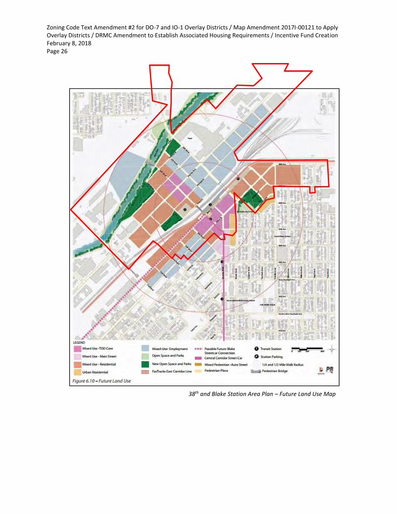
38th and Blake Station Area Plan – Future Land Use Map

Zoning Code Text Amendment #2 for DO-7 and IO-1 Overlay Districts / Map Amendment 2017I-00121 to Apply Overlay Districts / DRMC Amendment to Establish Associated Housing Requirements / Incentive Fund Creation February 8, 2018 Page 27
Elyria and Swansea Neighborhood Plan (2015) The proposed text and map amendment are consistent with the goals and objectives of the Elyria and Swansea Neighborhood Plan, including the following:
• Future land use recommendation for transit oriented development near the 38th & Blake RTD Station, including “higher density housing, services and employment opportunities near rail stations to provide for a diverse population with safe and convenient pedestrian access to rail transit.”
• Recommendations for councilmember-initiated rezonings to implement the plan vision (page 29).
• Recommendations for “discussion and collaboration with the community and applicable neighborhood associations” to consider whether taller heights may be appropriate nearest the 38th and Blake RTD Station (page 31).
Elyria and Swansea Neighborhoods Plan – Concept Land Use Map

Zoning Code Text Amendment #2 for DO-7 and IO-1 Overlay Districts / Map Amendment 2017I-00121 to Apply Overlay Districts / DRMC Amendment to Establish Associated Housing Requirements / Incentive Fund Creation February 8, 2018 Page 28
Northeast Downtown Neighborhoods Plan (2011) The proposed text and map amendment are consistent with the goals and objectives of the Northeast Downtown Neighborhoods Plan, including the following recommendations for the Ballpark/River North portion of the planning area:
• “Promote urban character with a build-to line to provide a consistent street edge and to support pedestrian activity. Reinforce the character and quality of public streets with buildings that provide consistent siting, pedestrian orientation, and access to the street. Minimize the visual impacts of parking by structuring it within the development, or by locating surface lots to the rear or side of buildings with access to/from the alley” (page 74).
• “Give prominence to the pedestrian realm as a defining element of neighborhood character. Maintain required ground story activation such as window transparency and street facing entrances. Locate commercial uses on the ground floor to activate buildings and the street” (page 74).
River North Plan (2003) The proposed text and map amendment are consistent with the goals and objectives of the River North Plan, including the following:
• “Develop and maintain a well-designed urban environment, promoting the use of designs and materials that reflect the community’s unique industrial character” (page 112).
• “Promote the development of affordable housing in the TOD district” (page 74).
• “Provide a range of housing options” (page 76).
River North Plan – Future Land Use Map

Zoning Code Text Amendment #2 for DO-7 and IO-1 Overlay Districts / Map Amendment 2017I-00121 to Apply Overlay Districts / DRMC Amendment to Establish Associated Housing Requirements / Incentive Fund Creation February 8, 2018 Page 29
3. The Proposed Denver Zoning Code Text and Map Amendment Further the Public
Health, Safety and Welfare of the City The proposed text and map amendments further the public health, safety, and general welfare of Denver residents by implementing adopted plan objectives to promote pedestrian-friendly design that supports use of alternative transportation and by ensuring that higher intensity development provides affordable housing and other community benefits.
4. The Proposed Denver Zoning Code Text and Map Amendment Result in Regulations
that are Uniform Across the District The proposed text and map amendments will result in uniform regulations applicable to all new buildings within land mapped with the DO-7 and IO-1 overlays.
Staff Recommendation
A. Denver Zoning Code Text Amendment (CB18-0016)
Based on the review criteria for a text amendment stated in the Denver Zoning Code (DZC), Section 12.4.11 (Text Amendment), Community Planning and Development (CPD) staff recommends approval for Denver Zoning Code Text Amendment #2.
B. Denver Zoning Code Map Amendment (CB18-0017) Based on the review criteria for a map amendment in the Denver Zoning Code (DZC), Section 12.4.10 (Map Amendment), CPD staff recommends approval for map amendment proposal #2017I-00121.
C. Denver Revised Municipal Code Amendment (CB18-0019) Office of Economic Development (OED) and CPD staff recommend approval for the Denver Revised Municipal Code (DRMC) amendment to create a new Chapter 27, Article VI establishing affordable housing requirements for the 38th and Blake Incentive Overlay (IO-1).
D. New “Affordable Housing Incentive Fee Fund” (CB18-0014) Department of Finance – Budget and Management Office (BMO), Office of Economic Development (OED) and CPD staff recommend approval of the proposed “Affordable Housing Incentive Fee Fund.”

Zoning Code Text Amendment #2 for DO-7 and IO-1 Overlay Districts / Map Amendment 2017I-00121 to Apply Overlay Districts / DRMC Amendment to Establish Associated Housing Requirements / Incentive Fund Creation February 8, 2018 Page 30
Attachments
A. Redline of City Council Filing Draft for Proposed Denver Zoning Code Text Amendment #2 B. Denver Zoning Code Map Amendment Proposal #2017I-00121 C. Draft Denver Revised Municipal Code Amendment to Establish New Chapter 27 Article VI with
Affordable Housing Requirements Linked to DZC 38th and Blake Station Area Incentive Overlay D. River North Design Overlay Summary Handout E. 38th and Blake Incentive Overlay Summary Handout F. 38th and Blake Incentive Overlay Financial Feasibility Study Memo G. RNO and Stakeholder Letters
• Cole Neighborhood RNO Statement (11/27/17)
• United Community Action Network RNO Statement (from Armando Payan 12/23/17)
• RiNo Art District RNO Statement (12/29/17)
• Curtis Park Neighbors RNO Statement (01/22/18)
• RiNo Art District RNO Request (02/06/18)
• Letter from RiNo Property Owners (6/30/17)
• Letter from RiNo Property Owners (11/17/17)
• Letter from Urban Land Conservancy (12/5/17)
• Letter from Thomas J. Ragonetti on behalf of Carmel Partners (12/5/17)
• Letter from Dick Farley (12/6/17)
• Letter from Elisabeth Teater (01/23/18) with response from Abe Barge (01/25/18)
Denver Zoning Code Text Amendment #2River North Design Overlay District (DO-7)
38th and Blake Station Area Incentive Overlay District (IO-1)REDLINE OF CITY COUNCIL FILING DRAFT 01/11/2018
This document contains a redlined draft of the proposed text amendments to create a new River North De-sign Overlay District, establish a new Incentive Overlay District category and create the 38th and Blake Station Incentive Overlay District. The City Council public hearing is scheduled for February 12, 2018.
1. Text in red underline is proposed new language.
2. Text in red strikethrough is proposed deleted language.
3. Pages with substantive additions (such as new code sections, requirements or clarifications) includea “RIVER NORTH DESIGN OVERLAY/38TH & BLAKE INCENTIVE OVERLAY TEXT AMENDMENT” header and“Amendment: 2” footer
4. Pages with redline changes that are not substantive (such as updated section numbers, figure num-bers or cross-references) are also included in this document, but do not have a special ArapahoeSquare header.
Note that this draft updates the Planning Board and City Council Land Use, Transportation and Infrastructure Committee drafts with edits for clarity, correctness, illustrative graphic, section references, and other non-sub-stantive matters, as well changes made necessary by such edits. While every effort is made to ensure doc-ument quality, page numbers, and amendment numbers may appear incorrect since both new and old text appears in a redlined draft. These are corrected in the final, “clean” version of the text amendment that has been filed for adoption by City Council.
Please visit www.denvergov.org/38blake to learn more about these proposed overlay zone districts.
Also visit our website at www.DenverGov.org/CPD, then click on Text Amendments under Zoning, to:
• Learn more about Text Amendments• Learn more about the process for this text amendment• Sign up for email newsletters
Please send any questions or comments to Abe Barge, Principal City Planner ([email protected]) or Senior City Planner Andrew Webb ([email protected])
ALL INTERESTED PERSONS AND ORGANIZATIONS SHOULD EXPRESS THEIR CONCERNS OR SUPPORT AT THE AT THE PUBLIC HEARING BEFORE CITY COUNCIL.
RiNo Overlays - Attachment A

2.3-2 |
Article 2. Using the CodeDivision 2.3 Code Organization
DENVER ZONING CODEJune 25, 2010 | Republished May 5, 2017
2.3.1.3 Design StandardsThe Design Standards Division establishes the intent of all applicable design standards, allowed building forms by zone district, building form standards and any exceptions or alternatives. A sum-mary table provides an overview for easy reference. Each building form has a set of illustrations and a table of standards to ensure clarity in interpretation.
2.3.1.4 Uses and Required Minimum ParkingUses and Parking provides a listing of all allowed uses by zone district. With each use category, the vehicle and bike parking requirements are listed.
Section 2.3.2 ARticLe 8: DoWntoWn neiGHBoRHooD conteXtThe Downtown Neighborhood Context is organized differently than Articles 3 through 7 due to the unique nature of the downtown zone districts. This Article contains all the zone districts within the city's downtown area and applicable regulations. The Downtown Neighborhood Context has a different zone district naming convention. The first letter is "D" to denote the Downtown Neighborhood Context. The second letters are abbreviations for the specific neighborhood within Downtown. For example: D-AS is Downtown Arapahoe Square. After providing the zoning regulations for each downtown zone district, there are Sections on design standards and the uses and minimum parking requirements.
Section 2.3.3 ARticLe 9: SPeciAL conteXtS AnD DiStRictSArticle 9 contains regulations for Special Contexts and Districts. Special Contexts and Districts are those that need to be treated differently due to specialized uses, forms, regulations and/or procedures. Special Contexts and Districts have a different zone district naming convention described within each Division. The first let-ters indicate the type of context or district with subsequent lettering or numbering when there is variation.
2.3.3.1 Industrial Context (I-MX, -A, -B): The Industrial Context establishes zone districts that allow vary-ing intensities and types of industrial forms and uses.
2.3.3.2 Campus Context (CMP-H, -H2, -EI, -EI2, -ENT, -NWC): The Campus Context establishes zone districts for larger scale sites offering healthcare, education/institution, entertainment, and the National Western Center.
2.3.3.3 Open Space Context (OS-A, -B, -C): The Open Space Context establishes zone districts for various types of park, recreational and open space land.
2.3.3.4 Districts (CO, UO, DO, IO, AIO): Overlay Districts are zone districts that apply in addition to the base zone district. There are Conservation Overlay Districts, Use Overlay Districts, Design Overlay Districts, Incentive Overlay Districts and the Airport Influence Overlay District.
2.3.3.5 Denver International Airport District: This district applies to the Denver International Airport.
2.3.3.6 O-1 Zone District: O-1 is a zone district that applies to various recreation, institutional, and utilities.
2.3.3.7 Planned Unit Development District: The Planned Unit Development District is a unique zone dis-trict that provides form, use, parking and other standards tailored to a particular site.
2.3.3.8 Master Planned Context: The Master Planned Context is intended for larger scale sites that will develop over a long period of time and in multiple phases. Within the Master Planned Context there is a menu of residential and mixed use zone district.
Section 2.3.4 ARticLeS 10 tHRoUGH 13: GeneRAL StAnDARDS AnD PRo-ceDUReSArticles 10 through 13 contain regulations that apply throughout the city and are not unique to a Neighbor-hood Context or Special Context. They are organized together so that common regulations are found in the same place such as use limitations, procedures, definitions and rules of measurement.
Amendment: 2
RIVER NORTH DESIGN OVERLAY/38TH & BLAKE INCENTIVE OVERLAY TEXT AMENDMENTCITY COUNCIL REDLINE DRAFT 01/11/18
RiNo Overlays - Attachment A

| 2.5-3
Article 2. Using the CodeDivision 2.5 Establishment of Zone Districts
DENVER ZONING CODEJune 25, 2010 | Republished May 5, 2017
MASTER PLANNED CONTEXT
M-RH-3 Row House 3
M-RX-3 Residential Mixed Use 3
M-RX-5 Residential Mixed Use 5
M-RX-5A Residential Mixed Use 5A
M-CC-5 Commercial Corridor 5
M-MX-5 Commercial Mixed Use 5
M-IMX-5 Industrial Mixed Use 5
M-IMX-8 Industrial Mixed Use 8
M-IMX-12 Industrial Mixed Use 12
M-GMX General Mixed Use
OVERLAY DISTRICTS
UO- Use Overlay District
CO- Conservation Overlay District
DO- Design Overlay District
IO- Incentive Overlay District
AIO- Airport Influence Overlay District
OTHER SPECIAL CONTEXTS OR ZONE DISTRICTS
PUD Planned Unit Development
PLANNED UNIT DEVELOPMENT CONTEXT
DIA Denver International Airport
O-1 Open Zone District
Amendment: 2
RIVER NORTH DESIGN OVERLAY/38TH & BLAKE INCENTIVE OVERLAY TEXT AMENDMENTCITY COUNCIL REDLINE DRAFT 01/11/18
RiNo Overlays - Attachment A
| 3.3-41
Article 3. Suburban Neighborhood ContextDivision 3.3 Design Standards
DENVER ZONING CODEJune 25, 2010 | Republished May 5, 2017
3.3.5.3 Street Level Active Uses in the S-MX-2A, -3A, -5A, -8A, -12A and S-MS Zone DistrictsA. Intent
To promote activity on the street and sidewalk, enhance safety and encourage a vibrant urban environment.
B. ApplicabilityThis Section 3.3.5.3 applies to the General building form in the S-MX-2A, -3A, -5A, -8A, -12A zone districts and the Shopfront building form in the S-MS zone districts.
C. Street Level Active Uses
1. Street Level active uses include all permitted primary uses except the following:a. Mini-storage Facility; orb. Wholesale Trade or Storage, Light.
2. Street Level active uses include all permitted accessory uses except the following:a. Car Wash Bay Accessory to Automobile Services or Hotel Uses; orb. Drive Through Facility Accessory to Eating/Drinking Establishments and to Retail
Sales, Service, and Repair Uses.
3. Street Level active uses shall not include Parking Spaces or Parking Aisles.
4. Street Level active uses shall occupy Street Level floor area for a minimum depth of 15 feet (may include the depth of a recessed entrance allowed to meet minimum pedestrian access standards).
5. The length of any build-to alternatives permitted by Section 3.3.6.1 shall not apply toward the required percentage of Street Level building frontage that must be occupied by a Street Level active use.
SeCtion 3.3.6 DESIGN STANDARD ALTERNATIVES 3.3.6.1 Required Build-To Alternatives
A. IntentTo help define the public realm and enhance the visual quality of the built environment where it is not possible to do so with building facades.
B. AllowanceThe following alternatives may be used singularly or in combination as alternatives to a re-quired build-to standard and may count toward the required build-to no more than as de-scribed in the table below, provided all alternatives meet the requirements stated in Section 13.1.5.67.E.
RiNo Overlays - Attachment A

3.3-42 |
Article 3. Suburban Neighborhood ContextDivision 3.3 Design Standards
DENVER ZONING CODEJune 25, 2010 | Republished May 5, 2017
REQUIRED BUILD-TO ALTERNATIVES
ZONE DISTRICT
PERMANENT OUTDOOR
PATIO SEATING (MAX INCREASE
IN BUILD-TO RANGE)
PRIVATE OPEN SPACE (MAX % OF BUILD-TO)
GARDEN WALL (MAX % OF BUILD-TO)
GARDEN WALL WITH COVERED
SEATING FOR PE-DESTRIANS (MAX % OF BUILD-TO)
PERGOLA (MAX % OF BUILD-TO)
ARCADE (MAX % OF BUILD-TO)
COURTYARD (MAX % OF BUILD-TO)
S-MUS-CC S-MS
na na 25%** 30%** 30%** 100% na
S-MX 10’* na 25%** 30%** 30%** 100% na
*Permitted increase in the maximum depth of the required build-to range.**If used in combination with each other, the garden wall, garden wall with covered seating for pedestrians and pergola alternatives may count toward no more than 30% of required build-to.
3.3.6.2 Primary Street Upper Story SetbackA. Intent
To provide flexibility while maintaining and promoting a pedestrian-scaled primary street.
B. ApplicabilityS-MX-8, S-MX-8A, S-MX-12, S-MX-12A
C. AlternativeWhen the building is placed at 0 feet on the Primary Street Zone Lot Line, then the Upper Story Setback above 5 stories or 70 feet may be reduced to 15 feet. This alternative only applies to portions of buildings placed at 0 feet on the Primary Street Zone Lot Line. Therefore, any portions of the building placed beyond 0 feet shall meet the Upper Story Setback stated in the building form table.
3.3.6.3 Transparency AlternativesA. Intent
To provide visual interest on building facades, to activate the public street and sidewalk, and enhance the visual quality of the built environment along Street Level facade areas where win-dows do not provide sufficient transparency.
B. AllowanceThe following alternatives may be used singularly or in combination as alternatives to a re-quired transparency standard and may count toward required transparency no more than as described in the table below, provided all alternatives meet the requirements stated in Section 13.1.6.2.A.45:
TRANSPARENCY ALTERNATIVES
ZONE DISTRICT
ZONE LOT LINE
DESIGNATION
DISPLAY CASES AND
AUTOMATED TELLER
MACHINES (MAX)
WALL DESIGN ELEMENTS (MAX)
PERMANENT OUTDOOR
EATING /SERVING
AREAS(MAX)
PERMANENT ART (MAX)
COMBINATION OF
ALTERNATIVES (MAX)
S-MU Primary Street 40% 50% 60% 40% 80%
Side Street 40% 50% 80% 40% 80%
RiNo Overlays - Attachment A

| 3.3-43
Article 3. Suburban Neighborhood ContextDivision 3.3 Design Standards
DENVER ZONING CODEJune 25, 2010 | Republished May 5, 2017
TRANSPARENCY ALTERNATIVES
ZONE DISTRICT
ZONE LOT LINE
DESIGNATION
DISPLAY CASES AND
AUTOMATED TELLER
MACHINES (MAX)
WALL DESIGN ELEMENTS (MAX)
PERMANENT OUTDOOR
EATING /SERVING
AREAS(MAX)
PERMANENT ART (MAX)
COMBINATION OF
ALTERNATIVES (MAX)
S-CC Primary Street 40% 50% 60% 40% 80%
Side Street 40% 100%, provided the wall design elements are
applied to the entirety (100%) of the length of
the Street Level wall.
80% 40% 80%*
S-MX Primary Street 40% 50% 60% 40% 80%
Side Street 40% 100%, provided the wall design elements are
applied to the entirety (100%) of the length of
the Street Level wall.
80% 40% 80%*
S-MS Primary Street 40% 50% 60% 40% 50%
Side Street 40% 50% 80% 40% 50%
*Wall design elements that are applied to the entire length of the Street Level wall may count toward up to 100% of required side street transparency.
3.3.6.4 Pedestrian Access (Entrance) AlternativesA. Intent
To provide a clear and obvious, publicly accessible route connecting the Primary Street to the primary uses within the building.
B. AllowanceIn the S-MX-2A, -3A, -5A, -8A, -12A zone districts for all building forms, one of the following may be used as an alternative to a required Entrance, provided that the alternative meets the design standards described in Section 13.1.6.2.B.4:
1. Courtyard or Plaza
2. Covered Walkway
3.3.6.5 Attached Garage AlternativeA. Intent
To allow for an attached garage, designed as an integral part of the building’s facade, to project forward of a primary street facing facade when the design of the entire building de-emphasizes the garage entrance and function.
B. ApplicabilityZone lots that meet both of the following may utilize this alternative:
1. Zoned S-SU, S-TH, or S-MU; and
2. Zone Lot Width along Primary Street is at least 100 feet.
C. AllowanceAn attached garage may be located closer to the minimum Primary Street setback line than the Primary Street facing facade(s) enclosing the primary use, if the attached garage complies with all of the following standards:
1. Garage doors shall not face the Primary Street (See Section 13.1.6.1.IL);
RiNo Overlays - Attachment A

4.3-44 |
Article 4. Urban Edge Neighborhood ContextDivision 4.3 Design Standards
DENVER ZONING CODEJune 25, 2010 | Republished May 5, 2017
B. AllowanceThe following alternatives may be used singularly or in combination as alternatives to a re-quired build-to standard and may count toward the required build-to no more than as de-scribed in the table below, provided all alternatives meet the requirements stated in Section 13.1.5.6.7.E:
REQUIRED BUILD-TO ALTERNATIVES
ZONE DISTRICT
PERMANENT OUTDOOR
PATIO SEATING (MAX INCREASE
IN BUILD-TO RANGE)
PRIVATE OPEN SPACE (MAX % OF BUILD-TO)
GARDEN WALL (MAX % OF BUILD-TO)
GARDEN WALL WITH COVERED
SEATING FOR PE-DESTRIANS (MAX % OF BUILD-TO)
PERGOLA (MAX % OF BUILD-TO)
ARCADE (MAX % OF BUILD-
TO)
COURTYARD (MAX % OF BUILD-TO)
E-RX na na 25%* 30%** 30%** 100% 100%
E-CCE-MX 10’* na 25%* 30%** 30%** 100% 100%
E-MS na na 25%* 30%** 30%** 100% na
*Permitted increase in the maximum depth of the required build-to range.**If used in combination with each other, the garden wall, garden wall with covered seating for pedestrians and pergola alternatives may count toward no more than 30% of required build-to.
4.3.6.2 Transparency AlternativesA. Intent
To provide visual interest on building facades, to activate the public street and sidewalk, and enhance the visual quality of the built environment along Street Level facade areas where win-dows do not provide sufficient transparency.
B. AllowanceThe following alternatives may be used singularly or in combination as alternatives to a re-quired transparency standard and may count toward required transparency no more than as described in the table below, provided all alternatives meet the requirements stated in Section 13.1.6.2.A.45:
TRANSPARENCY ALTERNATIVES
ZONE DISTRICT
ZONE LOT LINE
DESIGNATION
DISPLAY CASES AND
AUTOMATED TELLER
MACHINES (MAX)
WALL DESIGN ELEMENTS (MAX)
PERMANENT OUTDOOR
EATING /SERVING
AREAS(MAX)
PERMANENT ART (MAX)
COMBINA-TION OF
ALTERNA-TIVES (MAX)
E-MU Primary Street 40% 50% 60% 40% 80%
Side Street 40% 50% 80% 40% 80%
E-RX Primary Street 40% 50% 60% 40% 80%
Side Street 40% 50% 80% 40% 80%
E-CC Primary Street 40% 50% 60% 40% 80%
Side Street 40% 50% 80% 40% 80%
RiNo Overlays - Attachment A

| 4.3-45
Article 4. Urban Edge Neighborhood ContextDivision 4.3 Design Standards
DENVER ZONING CODEJune 25, 2010 | Republished May 5, 2017
TRANSPARENCY ALTERNATIVES
ZONE DISTRICT
ZONE LOT LINE
DESIGNATION
DISPLAY CASES AND
AUTOMATED TELLER
MACHINES (MAX)
WALL DESIGN ELEMENTS (MAX)
PERMANENT OUTDOOR
EATING /SERVING
AREAS(MAX)
PERMANENT ART (MAX)
COMBINA-TION OF
ALTERNA-TIVES (MAX)
E-MX Primary Street 40% 50% 60% 40% 80%
Side Street 40% 100%, provided the wall design elements are
applied to the entirety (100%) of the length of
the Street Level wall.
80% 40% 80%*
E-MS Primary Street 40% 50% 60% 40% 50%
Side Street 40% 50% 80% 40% 50%
*Wall design elements that are applied to the entire length of the Street Level wall may count toward up to 100% of re-quired side street transparency.
4.3.6.3 Pedestrian Access (Entrance) AlternativesA. Intent
To provide a clear and obvious, publicly accessible route connecting the Primary Street to the primary uses within the building.
B. AllowanceIn E-MX and E-RX zone districts, for all building forms except the Row House building form, one of the following may be used as an alternative to a required Entrance, provided that the alterna-tive meets the design standards described in Section 13.1.6.2.B.34:
1. Courtyard or Plaza
2. Covered Walkway
SeCtIon 4.3.7 DeSIGn StAnDARD eXCePtIonS4.3.7.1 Height Exceptions
A. IntentTo allow building features to exceed maximum height for utility purposes and/or limited recre-ation or building amenities in the higher intensity zone districts/larger forms.
B. Applicability and Standards:
1. The following building features are allowed to exceed height in feet, stories, bulk plane and upper story setbacks as described in the table below, subject to the standards in this section 4.3.7.1.B.
2. Unoccupied elevator penthouses, stair enclosures, and enclosed or unenclosed mechani-cal equipment including vertical or sloped screen walls for such equipment granted an exception for height in stories shall only be as large as necessary to achieve the intended function of the feature and shall not exceed the minimum required dimensions defined in the Denver Building and Fire Code.
3. An elevator lobby granted an exception for height in stories shall be no larger in area than the area of the elevator shaft which it abuts, measured to the exterior walls.
4. Unoccupied building features shall not include space for living, sleeping, eating, cooking, bathrooms, toilet compartments, closets, halls, storage, or similar space.
RiNo Overlays - Attachment A

5.3-40 |
Article 5. Urban Neighborhood ContextDivision 5.3 Design Standards
DENVER ZONING CODEJune 25, 2010 | Republished May 5, 2017
Section 5.3.6 DeSiGn StAnDARD ALteRnAtiVeS5.3.6.1 Required Build-To Alternatives
A. intentTo help define the public realm and enhance the visual quality of the built environment where it is not possible to define the street and public sidewalk edge with building facades.
B. AllowanceThe following alternatives may be used singularly or in combination as alternatives to a re-quired build-to standard and may count toward the required build-to no more than as de-scribed in the table below, provided all alternatives meet the requirements stated in Section 13.1.5.6.7.E:
REQUIRED BUILD-TO ALTERNATIVES
ZONE DISTRICT
PERMANENT OUTDOOR
PATIO SEATING (MAX INCREASE
IN BUILD-TO RANGE)
PRIVATE OPEN SPACE (MAX % OF BUILD-TO)
GARDEN WALL (MAX % OF BUILD-TO)
GARDEN WALL WITH COVERED
SEATING FOR PE-DESTRIANS (MAX % OF BUILD-TO)
PERGOLA (MAX % OF BUILD-TO)
ARCADE (MAX % OF BUILD-
TO)
COURTYARD (MAX % OF BUILD-TO)
U-RXU-MX na na 25%* 30%* 30%* 100% 100%
U-MS na na 25%* 30%* 30%* 100% na
*If used in combination, the garden wall, garden wall with covered seating for pedestrians and pergola alternatives may count toward no more than 30% of required build-to.
5.3.6.2 Transparency AlternativesA. intent
To provide visual interest on building facades, to activate the public street and sidewalk, and enhance the visual quality of the built environment along Street Level facade areas where win-dows do not provide sufficient transparency.
B. AllowanceThe following alternatives may be used singularly or in combination as alternatives to a re-quired transparency standard and may count toward required transparency no more than as described in the table below, provided all alternatives meet the requirements stated in Section 13.1.6.2.A.45:
TRANSPARENCY ALTERNATIVES
ZONE DISTRICT
ZONE LOT LINE
DESIGNATION
DISPLAY CASES AND AUTOMATED
TELLER MA-CHINES (MAX)
WALL DESIGN ELEMENTS (MAX)
PERMANENT OUTDOOR EAT-
ING /SERVING
AREAS(MAX)
PERMANENT ART (MAX)
COMBINATION OF
ALTERNATIVES (MAX)
U-RX Primary Street 40% 50% 60% 40% 80%
Side Street 40% 50% 80% 40% 80%
U-MX Primary Street 40% 50% 60% 40% 80%
Side Street 40% 100%, provided the wall design elements are
applied to the entirety (100%) of the length of
the Street Level wall.
80% 40% 80%*
RiNo Overlays - Attachment A

| 5.3-41
Article 5. Urban Neighborhood ContextDivision 5.3 Design Standards
DENVER ZONING CODEJune 25, 2010 | Republished May 5, 2017
TRANSPARENCY ALTERNATIVES
ZONE DISTRICT
ZONE LOT LINE
DESIGNATION
DISPLAY CASES AND AUTOMATED
TELLER MA-CHINES (MAX)
WALL DESIGN ELEMENTS (MAX)
PERMANENT OUTDOOR EAT-
ING /SERVING
AREAS(MAX)
PERMANENT ART (MAX)
COMBINATION OF
ALTERNATIVES (MAX)
U-MS Primary Street 40% 50% 60% 40% 50%
Side Street 40% 50% 80% 40% 50%
*Wall design elements that are applied to the entire length of the Street Level wall may count toward up to 100% of required side street transparency.
5.3.6.3 Pedestrian Access (Entrance) AlternativesA. intent
To provide a clear and obvious, publicly accessible route connecting the Primary Street to the primary uses within the building.
B. AllowanceIn U-MX and U-RX zone districts, for all building forms except the Row House building form, one of the following may be used as an alternative to a required, provided that the alternative meets the design standards described in Section Section 13.1.6.2.B.34:
1. Courtyard or Plaza
2. Covered Walkway
Section 5.3.7 DeSiGn StAnDARD eXcePtionS5.3.7.1 Height Exceptions
A. intentTo allow building features to exceed maximum height for utility purposes and/or limited recre-ation or building amenities in the higher intensity zone districts/larger forms.
B. Applicability and Standards
1. The following building features are allowed to exceed height in feet, stories, bulk plane and upper story setbacks as described in the table below, subject to the standards in this section 5.3.7.1.B.
2. Unoccupied elevator penthouses, stair enclosures, and enclosed or unenclosed mechani-cal equipment including vertical or sloped screen walls for such equipment granted an exception for height in stories shall only be as large as necessary to achieve the intended function of the feature and shall not exceed the minimum required dimensions defined in the Denver Building and Fire Code.
3. An elevator lobby granted an exception for height in stories shall be no larger in area than the area of the elevator shaft which it abuts, measured to the exterior walls.
4. Unoccupied building features shall not include space for living, sleeping, eating, cooking, bathrooms, toilet compartments, closets, halls, storage, or similar space.
RiNo Overlays - Attachment A

6.3-38 |
Article 6. General Urban Neighborhood ContextDivision 6.3 Design Standards
DENVER ZONING CODEJune 25, 2010 | Republished May 5, 2017
Section 6.3.6 DeSiGn StAnDARD ALteRnAtiVeS6.3.6.1 Required Build-To Alternatives
A. intentTo help define the public realm and enhance the visual quality of the built environment where it is not possible to define the street and public sidewalk edge with building facades.
B. AllowanceThe following alternatives may be used singularly or in combination as alternatives to a re-quired build-to standard and may count toward the required build-to no more than as de-scribed in the table below, provided all alternatives meet the requirements stated in Section 13.1.5.6.7.E:
REQUIRED BUILD-TO ALTERNATIVES
ZONE DISTRICT
PERMANENT OUTDOOR
PATIO SEATING (MAX INCREASE
IN BUILD-TO RANGE)
PRIVATE OPEN SPACE (MAX % OF BUILD-TO)
GARDEN WALL (MAX % OF BUILD-TO)
GARDEN WALL WITH COVERED
SEATING FOR PE-DESTRIANS (MAX % OF BUILD-TO)
PERGOLA (MAX % OF BUILD-TO)
ARCADE (MAX % OF BUILD-
TO)
COURTYARD (MAX % OF BUILD-TO)
G-RXG-MX na na 25%* 30%* 30%* 100% 100%
G-RHG-MUG-MS
na na 25%* 30%* 30%* 100% na
*If used in combination with each other, the garden wall, garden wall with covered seating for pedestrians and pergola alternatives may count toward no more than 30% of required build-to.
6.3.6.2 Transparency AlternativesA. intent
To provide visual interest on building facades, to activate the public street and sidewalk, and enhance the visual quality of the built environment along Street Level facade areas where win-dows do not provide sufficient transparency.
B. AllowanceThe following alternatives may be used singularly or in combination as alternatives to a re-quired transparency standard and may count toward required transparency no more than as described in the table below, provided all alternatives meet the requirements stated in Section 13.1.6.2.A.45:
TRANSPARENCY ALTERNATIVES
ZONE DISTRICT
ZONE LOT LINE
DESIGNATION
DISPLAY CASES AND
AUTOMATED TELLER
MACHINES (MAX)
WALL DESIGN ELEMENTS (MAX)
PERMANENT OUTDOOR
EATING /SERVING
AREAS(MAX)
PERMANENT ART (MAX)
COMBINA-TION OF
ALTERNA-TIVES (MAX)
G-MU Primary Street 40% 50% 60% 40% 80%
Side Street 40% 50% 80% 40% 80%
G-RO Primary Street 40% 50% 60% 40% 80%
Side Street 40% 50% 80% 40% 80%
G-RX Primary Street 40% 50% 60% 40% 80%
Side Street 40% 50% 80% 40% 80%
RiNo Overlays - Attachment A

| 6.3-39
Article 6. General Urban Neighborhood ContextDivision 6.3 Design Standards
DENVER ZONING CODEJune 25, 2010 | Republished May 5, 2017
TRANSPARENCY ALTERNATIVES
ZONE DISTRICT
ZONE LOT LINE
DESIGNATION
DISPLAY CASES AND
AUTOMATED TELLER
MACHINES (MAX)
WALL DESIGN ELEMENTS (MAX)
PERMANENT OUTDOOR
EATING /SERVING
AREAS(MAX)
PERMANENT ART (MAX)
COMBINA-TION OF
ALTERNA-TIVES (MAX)
G-MX Primary Street 40% 50% 60% 40% 80%
Side Street 40% 100%, provided the wall design elements are
applied to the entirety (100%) of the length of
the Street Level wall.
80% 40% 80%*
G-MS Primary Street 40% 50% 60% 40% 50%
Side Street 40% 50% 80% 40% 50%
*Wall design elements that are applied to the entire length of the Street Level wall may count toward up to 100% of re-quired side street transparency.
6.3.6.3 Pedestrian Access (Entrance) AlternativesA. intent
To provide a clear and obvious, publicly accessible route connecting the Primary Street to the primary uses within the building.
B. AllowanceIn the G-RO, G-MU, G-MX and G-RX zone districts for all building forms except Row House, one of the following may be used as an alternative to a required Entrance, provided that the alterna-tive meets the design standards described in Section 13.1.6.2.B.34:
1. Courtyard or Plaza
2. Covered Walkway
Section 6.3.7 DeSiGn StAnDARD eXcePtionS6.3.7.1 Height Exceptions
A. intentTo allow building features to exceed maximum height for utility purposes and/or limited recre-ation or building amenities in the higher intensity zone districts/larger forms.
B. Applicability and Standards:
1. The following building features are allowed to exceed height in feet, stories, bulk plane and upper story setbacks as described in the table below, subject to the standards in this section 6.3.7.1.B.
2. Unoccupied elevator penthouses, stair enclosures, and enclosed or unenclosed mechani-cal equipment including vertical or sloped screen walls for such equipment granted an exception for height in stories shall only be as large as necessary to achieve the intended function of the feature and shall not exceed the minimum required dimensions defined in the Denver Building and Fire Code.
3. An elevator lobby granted an exception for height in stories shall be no larger in area than the area of the elevator shaft which it abuts, measured to the exterior walls.
4. Unoccupied building features shall not include space for living, sleeping, eating, cooking, bathrooms, toilet compartments, closets, halls, storage, or similar space.
RiNo Overlays - Attachment A

| 7.3-29
Article 7. Urban Center Neighborhood ContextDivision 7.3 Design Standards
DENVER ZONING CODEJune 25, 2010 | Republished May 5, 2017
5. The length of any build-to alternatives permitted by Section 7.3.6.1 shall not apply toward the required percentage of Street Level building frontage that must be occupied by a Street Level active use.
Section 7.3.6 DeSiGn StAnDARD ALteRnAtiVeS7.3.6.1 Required Build-To Alternatives
A. intentTo help define the public realm and enhance the visual quality of the built environment where it is not possible to define the street and public sidewalk edge with building facades.
B. AllowanceThe following alternatives may be used singularly or in combination as alternatives to a re-quired build-to standard and may count toward the required build-to no more than as de-scribed in the table below, provided all alternatives meet the requirements stated in Section 13.1.5.6.7.E:
REQUIRED BUILD-TO ALTERNATIVES
ZONE DISTRICT
PERMANENT OUTDOOR PATIO
SEATING (MAX IN-CREASE IN BUILD-
TO RANGE)
PRIVATE OPEN SPACE (MAX % OF BUILD-TO)
GARDEN WALL (MAX % OF BUILD-TO)
GARDEN WALL WITH COVERED
SEATING FOR PE-DESTRIANS (MAX % OF BUILD-TO)
PERGOLA (MAX % OF BUILD-TO)
ARCADE (MAX % OF BUILD-
TO)
COURTYARD (MAX % OF BUILD-TO)
C-RXC-MX na na 25%*** 30%*** 30%*** 100% 100%
C-MS na na 25%*** 30%*** 30%*** 100% na
C-CCN 5’* 100%** 25%*** 30%*** 30%*** 100% na
*Permitted increase in the maximum depth of the required build-to range. ** If used in combination with each other, the permanent outdoor patio seating and private open space alternatives may count toward 100% of required build-to, provided the outdoor patio seating complies with the private open space rule of measurement in Article 13. ***If used in combination with each other, the garden wall, garden wall with covered seating for pedestrians and pergola alternatives may count toward no more than 30% of required build-to.
7.3.6.2 Primary Street Upper Story SetbackA. intent
To provide flexibility while maintaining and promoting a pedestrian-scaled main street.
B. ApplicabilityC-MS-8, C-MS-12
c. AlternativeWhen the building is placed at 0 feet on the Primary Street Zone Lot Line, then the Upper Story Setback above 5 stories or 70 feet may be reduced to 15 feet. This alternative only applies to portions of buildings placed at 0 feet on the Primary Street Zone Lot Line. Therefore, any portions of the building placed beyond 0 feet shall meet the Upper Story Setback stated in the building form table.
7.3.6.3 Transparency AlternativesA. intent
To provide visual interest on building facades, to activate the public street and sidewalk, and enhance the visual quality of the built environment along Street Level facade areas where win-dows do not provide sufficient transparency.
RiNo Overlays - Attachment A

7.3-30 |
Article 7. Urban Center Neighborhood ContextDivision 7.3 Design Standards
DENVER ZONING CODEJune 25, 2010 | Republished May 5, 2017
B. AllowanceThe following alternatives may be used singularly or in combination as alternatives to a re-quired transparency standard and may count toward required transparency no more than as described in the table below, provided all alternatives meet the requirements stated in Section 13.1.6.2.A.45:
TRANSPARENCY ALTERNATIVES
ZONE DISTRICT
ZONE LOT LINE
DESIGNATION
DISPLAY CASES AND
AUTOMATED TELLER
MACHINES (MAX)
WALL DESIGN ELEMENTS (MAX)
PERMANENT OUTDOOR
EATING /SERVING
AREAS(MAX)
PERMANENT ART (MAX)
COMBINATION OF ALTERNATIVES
(MAX)
C-RX Primary Street 40% 50% 60% 40% 80%
Side Street 40% 50% 80% 40% 80%
C-MX Primary Street 40% 50% 60% 40% 80%
Primary Street B
40% 100%, provided the wall design elements are applied to the entirety (100%) of the
length of the Street Level wall.
60% 40% 80%*
Side Street 40% 100%, provided the wall design elements are applied to the entirety (100%) of the
length of the Street Level wall.
80% 40% 80%*
C-MS Primary Street 40% 50% 60% 40% 50%
Side Street 40% 50% 80% 40% 50%
*Wall design elements that are applied to the entire length of the Street Level wall may count toward up to 100% of required side street transparency.
7.3.6.4 Pedestrian Access (Entrance) AlternativesA. intent
To provide a clear and obvious, publicly accessible route connecting the Primary Street to the primary uses within the building.
B. AllowanceIn C-MX and C-RX zone districts, for all building forms except the Row House building form, one of the following may be used as an alternative to a required Entrance, provided that the alterna-tive meets the design standards described in Section Section 13.1.6.2.A.34:
1. Courtyard or Plaza
2. Covered Walkway
Section 7.3.7 DeSiGn StAnDARD eXcePtionS7.3.7.1 Height Exceptions
A. intentTo allow building features to exceed maximum height for utility purposes and/or limited recre-ation or building amenities in the higher intensity zone districts/larger forms.
RiNo Overlays - Attachment A

Article 8. Downtown Neighborhood ContextDivision 8.8 Downtown Arapahoe Square 12+ and 20+ Districts
| 8.8-17 DENVER ZONING CODEJune 25, 2010 | Republished May 5, 2017
C. Allowance
1. Uses that meet the Limitation on Visible Parking above Street Level shall include all pri-mary uses, but shall not include Parking Spaces or Parking Aisles for the minimum per-centage of the Primary Street-facing zone lot width specified in the building form table.
2. Uses that meet the Limitation on Visible Parking above Street Level shall occupy floor area above Street Level for a minimum depth of 15 feet from the Primary Street frontage (may include the depth of recessed balcony or terrace areas and insets for building articu-lation up to 10 feet in depth).
SeCtion 8.8.6 DeSiGn StAnDARD ALteRnAtiVeS FoR DoWntoWn ARAP-AHoe SQUARe 12+ AnD DoWntoWn ARAPAHoe SQUARe 20+ DiStRiCtS8.8.6.1 Required Build-To Alternatives in D-AS-12+ and D-AS-20+ Districts
A. intentTo help define the public realm and enhance the visual quality of the built environment where it is not possible to define the street and public sidewalk edge with building facades.
B. AllowanceThe following alternative may be used as an alternative to a required build-to standard and may count toward the required build-to no more than as described in the table below, provided it meets the requirements stated in Section 13.1.5.6.7.E:
REQUIRED BUILD-TO ALTERNATIVE
ZONE DISTRICT PRIVATE OPEN SPACE (MAX % OF BUILD-TO)
D-AS-12+D-AS-20+ 25%
8.8.6.2 Primary Street Upper Story Setback Alternative for 21st Street & Park Avenue in D-AS-12+ and D-AS-20+ Districts
A. intentTo allow a flexible alternative for creative designs fronting 21st Street and Park Avenue that maintain a building setback at or below 5 stories and 70 feet, but do not meet the specific Pri-mary Street Upper Story Setback requirements set forth in the building form tables.
B. ApplicabilityThis Section 8.8.6.2 applies to Primary Street upper story setbacks on the 21st Street and Park Avenue frontage of all building forms in the D-AS-12+ and D-AS-20+ zone districts.
C. AllowanceThe Zoning Administrator may approve an alternative Primary Street Upper Story setback design that does not meet the specific Upper Story setback requirements set forth in the build-ing form standards tables where the alternative is found to meet the design standards and guidelines for the Upper Story setback alternative on 21st Street and Park Avenue in the Design Standards and Guidelines for Arapahoe Square.
RiNo Overlays - Attachment A

| TOC-i DENVER ZONING CODEJune 25, 2010 | Republished May 5, 2017
Contents
ARTICLE 9. SPECIAL CONTEXTS AND DISTRICTSDIVISION 9.1 INDUSTRIAL CONTEXT (I-MX, I-A, I-B) . . . . . . . . . . . . . . . . . . . . . . . . . . . 9.1-1
Section 9.1.1 Industrial Context Description . . . . . . . . . . . . . . . . . . . . . . . . . . . . . . . . . . . . . . . . . . .9.1-1Section 9.1.2 Districts Established . . . . . . . . . . . . . . . . . . . . . . . . . . . . . . . . . . . . . . . . . . . . . . . . . . .9.1-2Section 9.1.3 Design Standards . . . . . . . . . . . . . . . . . . . . . . . . . . . . . . . . . . . . . . . . . . . . . . . . . . . . .9.1-3Section 9.1.4 Uses and Required Minimum Parking . . . . . . . . . . . . . . . . . . . . . . . . . . . . . . . . . . . .9.1-26
DIVISION 9.2 CAMPUS CONTEXT (CMP) . . . . . . . . . . . . . . . . . . . . . . . . . . . . . . . . . . . . . 9.2-1Section 9.2.1 Campus Context Description . . . . . . . . . . . . . . . . . . . . . . . . . . . . . . . . . . . . . . . . . . . .9.2-1Section 9.2.2 Districts Established . . . . . . . . . . . . . . . . . . . . . . . . . . . . . . . . . . . . . . . . . . . . . . . . . . .9.2-2Section 9.2.3 Campus Healthcare and Healthcare 2 (CMP-H, CMP-H2) . . . . . . . . . . . . . . . . . . . . .9.2-2Section 9.2.4 Campus-Education/Institution (CMP-EI, CMP-EI2) . . . . . . . . . . . . . . . . . . . . . . . . . . .9.2-9Section 9.2.5 Campus- Entertainment (CMP-ENT) . . . . . . . . . . . . . . . . . . . . . . . . . . . . . . . . . . . . .9.2-15Section 9.2.6 Campus - National Western Center (CMP-NWC) . . . . . . . . . . . . . . . . . . . . . . . . . . .9.2-19Section 9.2.7 Design Standard Exceptions CMP-H, CMP-H2; CMP-EI, CMP-EI2;
CMP-ENT; CMP-NWC . . . . . . . . . . . . . . . . . . . . . . . . . . . . . . . . . . . . . . . . . . . . . . . . .9.2-22Section 9.2.7 Uses and Required Minimum Parking . . . . . . . . . . . . . . . . . . . . . . . . . . . . . . . . . . . .9.2-36
DIVISION 9.3 OPEN SPACE CONTEXT (OS-A, OS-B, OS-C) . . . . . . . . . . . . . . . . . . . . . . . 9.3-1Section 9.3.1 Open Space Context Description . . . . . . . . . . . . . . . . . . . . . . . . . . . . . . . . . . . . . . . . .9.3-1Section 9.3.2 Districts Established . . . . . . . . . . . . . . . . . . . . . . . . . . . . . . . . . . . . . . . . . . . . . . . . . . .9.3-2Section 9.3.3 Primary Building Form Standards . . . . . . . . . . . . . . . . . . . . . . . . . . . . . . . . . . . . . . . .9.3-2Section 9.3.4 Uses and Required Minimum Parking . . . . . . . . . . . . . . . . . . . . . . . . . . . . . . . . . . . . .9.3-5
DIVISION 9.4 OVERLAY ZONE DISTRICTS . . . . . . . . . . . . . . . . . . . . . . . . . . . . . . . . . . . . 9.4-1Section 9.4.1 General Intent . . . . . . . . . . . . . . . . . . . . . . . . . . . . . . . . . . . . . . . . . . . . . . . . . . . . . . . .9.4-1Section 9.4.2 Overlay Zone Districts Established. . . . . . . . . . . . . . . . . . . . . . . . . . . . . . . . . . . . . . . .9.4-1Section 9.4.3 Conservation Overlay District (CO-) . . . . . . . . . . . . . . . . . . . . . . . . . . . . . . . . . . . . . . .9.4-1Section 9.4.4 Use Overlay Districts (UO-) . . . . . . . . . . . . . . . . . . . . . . . . . . . . . . . . . . . . . . . . . . . .9.4-12Section 9.4.5 Design Overlay Districts (DO-) . . . . . . . . . . . . . . . . . . . . . . . . . . . . . . . . . . . . . . . . . .9.4-16Section 9.4.6 Incentive Overlay Districts (IO-) . . . . . . . . . . . . . . . . . . . . . . . . . . . . . . . . . . . . . . . . .9.4-45
DIVISION 9.5 DENVER INTERNATIONAL AIRPORT ZONE DISTRICTS AND O-1 ZONE DISTRICT . . . . . . . . . . . . . . . . . . . . . . . . . . . . . . . . . . . . . . . . . . . . . . . . . . . 9.5-1
Section 9.5.1 Districts Established . . . . . . . . . . . . . . . . . . . . . . . . . . . . . . . . . . . . . . . . . . . . . . . . . . .9.5-1Section 9.5.2 Denver International Airport Zone District (DIA) . . . . . . . . . . . . . . . . . . . . . . . . . . . .9.5-2Section 9.5.3 DIA Influence Area Overlay Zone (AIO-) . . . . . . . . . . . . . . . . . . . . . . . . . . . . . . . . . . .9.5-2Section 9.5.4 O-1 Zone District . . . . . . . . . . . . . . . . . . . . . . . . . . . . . . . . . . . . . . . . . . . . . . . . . . . . .9.5-4Section 9.5.5 Uses and Required Minimum Parking . . . . . . . . . . . . . . . . . . . . . . . . . . . . . . . . . . . . .9.5-4
DIVISION 9.6 PLANNED UNIT DEVELOPMENT DISTRICT (PUD) . . . . . . . . . . . . . . . . . 9.6-1Section 9.6.1 Planned Unit Development District (PUD) . . . . . . . . . . . . . . . . . . . . . . . . . . . . . . . . .9.6-1
DIVISION 9.7 MASTER PLANNED CONTEXT (M-RH, M-RX, M-CC, M-MX, M-IMX, M-GMX) . . . . . . . . . . . . . . . . . . . . . . . . . . . . . . . . . . . . . . . . . . . . . . . . . . . . 9.7-1
Section 9.7.1 Master Planned Context Description . . . . . . . . . . . . . . . . . . . . . . . . . . . . . . . . . . . . .9.7-1Section 9.7.2 Districts Established . . . . . . . . . . . . . . . . . . . . . . . . . . . . . . . . . . . . . . . . . . . . . . . . . . .9.7-2Section 9.7.3 Design Standards . . . . . . . . . . . . . . . . . . . . . . . . . . . . . . . . . . . . . . . . . . . . . . . . . . . . .9.7-4Section 9.7.4 Detached Accessory Building Form Standards . . . . . . . . . . . . . . . . . . . . . . . . . . . . .9.7-30Section 9.7.5 Supplemental Design Standards . . . . . . . . . . . . . . . . . . . . . . . . . . . . . . . . . . . . . . . .9.7-40Section 9.7.6 Design Standard Alternatives . . . . . . . . . . . . . . . . . . . . . . . . . . . . . . . . . . . . . . . . . .9.7-42Section 9.7.7 Design Standard Exceptions . . . . . . . . . . . . . . . . . . . . . . . . . . . . . . . . . . . . . . . . . . . .9.7-44Section 9.7.8 Reference to Other Design standards . . . . . . . . . . . . . . . . . . . . . . . . . . . . . . . . . . . .9.7-61Section 9.7.9 Uses and Required Minimum Parking . . . . . . . . . . . . . . . . . . . . . . . . . . . . . . . . . . . .9.7-61
Amendment: 2
RIVER NORTH DESIGN OVERLAY/38TH & BLAKE INCENTIVE OVERLAY TEXT AMENDMENTCITY COUNCIL REDLINE DRAFT 01/11/18
RiNo Overlays - Attachment A

Article 9. Special Contexts and DistrictsDivision 9.1 Industrial Context
| 9.1-9 DENVER ZONING CODEJune 25, 2010 | Republished May 5, 2017
9.1.3.5 Design Standards AlternativesA. Required Build-To Alternatives
1. IntentTo help define the public realm and enhance the visual quality of the built environment where it is not possible to define the street and public sidewalk edge with building fa-cades.
2. AllowanceThe following alternatives may be used singularly or in combination as alternatives to a required build-to standard and may count toward the required build-to no more than as described in the table below, provided all alternatives meet the requirements stated in Section 13.1.5.6.7.E:
REQUIRED BUILD-TO ALTERNATIVES
ZONE DISTRICT
PERMANENT OUTDOOR
PATIO SEATING (MAX INCREASE
IN BUILD-TO RANGE)
PRIVATE OPEN SPACE (MAX % OF BUILD-TO)
GARDEN WALL (MAX % OF BUILD-TO)
GARDEN WALL WITH COVERED
SEATING FOR PE-DESTRIANS (MAX % OF BUILD-TO)
PERGOLA (MAX % OF BUILD-TO)
ARCADE (MAX % OF BUILD-
TO)
COURTYARD (MAX % OF BUILD-TO)
I-MX na na 25%* 30%* 30%* 100% na
*If used in combination with each other, the garden wall, garden wall with covered seating for pedestrians and pergola alternatives may count toward no more than 30% of required build-to.
B. Transparency Alternatives
1. IntentTo provide visual interest on building facades, to activate the public street and sidewalk, and enhance the visual quality of the built environment along Street Level facade areas where windows do not provide sufficient transparency.
2. AllowanceThe following alternatives may be used singularly or in combination as alternatives to a required transparency standard and may count toward required transparency no more than as described in the table below, provided all alternatives meet the requirements stated in Section 13.1.6.2.A.5:
TRANSPARENCY ALTERNATIVES
ZONE DISTRICT
ZONE LOT LINE
DESIGNATION
DISPLAY CASES AND AUTOMATED TELLER
MACHINES (MAX)
WALL DESIGN ELEMENTS (MAX)
PERMANENT OUTDOOR
EATING /SERVING
AREAS(MAX)
PERMANENT ART (MAX)
COMBINATION OF
ALTERNATIVES (MAX)
I-MX Primary Street 40% 50% 60% 40% 80%
Side Street 40% 100%, provided the wall design elements are
applied to the entirety (100%) of the length of
the Street Level wall.
80% 40% 80%*
*Wall design elements that are applied to the entire length of the Street Level wall may count toward up to 100% of required side street transparency.
RiNo Overlays - Attachment A

Article 9. Special Contexts and DistrictsDivision 9.4 Overlay Zone Districts
| 9.4-1 DENVER ZONING CODEJune 25, 2010 | Republished May 5, 2017
DIVISION 9.4 OVERLAY ZONE DISTRICTSSECTION 9.4.1 GENERAL INTENTOverlay Zone Districts are generally intended, in special and unique cases, to provide a vehicle to supplement otherwise generally applicable zone district standards with additional use or design limits, allowances, and prohibitions.
SECTION 9.4.2 OVERLAY ZONE DISTRICTS ESTABLISHEDTo carry out the provisions of this Code, the following overlay zone districts have been established and are ap-plied to property as set forth on the Official Map.
OVERLAY ZONE DISTRICTS
CO- Conservation Overlay District
UO- Use Overlay District
DO- Design Overlay District
IO- Incentive Overlay District
9.4.2.1 Process to Establish Overlay Zone Districts - Text Amendment & Rezoning RequiredCreation of an overlay zone district shall be by text amendment according to Section 12.4.11, Text Amendment, to codify the standards established within the overlay, and by an official map amend-ment (rezoning) according to Section 12.4.10. With the Manager’s approval, the map amendment may be filed and reviewed concurrent with the text amendment according to Section 12.3.3.9, Concurrent Applications. In no case, however, shall the map amendment be approved until the text amendment creating the overlay zone district is approved.
9.4.2.2 Effect of Underlying Zone District DesignationAll of the provisions of the underlying zone district shall be in full force and effect, unless such provisions are specifically varied by the provisions of the applicable overlay zone district; provided, however, except in an approved use overlay zone district (-UO), an overlay zone district shall not be used to add to the specific permitted uses in the underlying district, nor shall it be used to prohibit specific permitted uses in the underlying district.
9.4.2.3 Effect of Overlay Zone District DesignationAll zoning applications within a specific overlay zone district shall comply with the applicable provi-sions of that overlay zone district, and the underlying zone district, and shall be reviewed under this Code to assure such compliance. Where the provisions of the overlay zone district are different from (e.g., in the case of an overlay use district), or more restrictive than (e.g., in the case of a neigh-borhood conservation overlay zone district) the provisions of the underlying zoning designation, the provisions of the overlay zone district shall apply. A change in the underlying zone district does not change the content or applicability of the overlay zone provisions.
SECTION 9.4.3 CONSERVATION OVERLAY DISTRICT (CO-)9.4.3.1 Purpose
The Conservation Overlay District is intended to provide a vehicle to initiate and implement programs for the revitalization or conservation of specific areas within Denver possessing distinc-tive features, identity, or character worthy of retention and enhancement. A Conservation Overlay District takes effect through adoption of area specific standards that will facilitate maintenance and protection of the area’s existing character and the development of vacant or under used lots. The overlay may also be used to establish specific design guidelines that are more detailed than the standards of this Code for use during review of development within the overlay zone district.
Amendment: 2
RIVER NORTH DESIGN OVERLAY/38TH & BLAKE INCENTIVE OVERLAY TEXT AMENDMENTCITY COUNCIL REDLINE DRAFT 01/11/18
RiNo Overlays - Attachment A

Article 9. Special Contexts and DistrictsDivision 9.4 Overlay Zone Districts
| 9.4-17 DENVER ZONING CODEJune 25, 2010 | Republished May 5, 2017
B. Modification of Underlying Zone District Standards
1. Modification of Permitted Uses and Use Limitations Not AllowedA Design Overlay District shall not be used to add to the specific permitted uses in the underlying zone district, nor shall it be used to prohibit specific permitted uses in the underlying district, nor shall it be used to add, revise, or delete use limitations applicable to specific permitted uses in the underlying zone district.
2. All Other Applicable Standards -- Modification AllowedAll of the provisions of the underlying zone district shall be in full force and effect, unless such provisions are specifically varied by the provisions of the applicable design overlay zone district, in which case the standard in the design overlay zone district shall apply.
9.4.5.3 Design Overlay Districts EstablishedThe following Design Overlay Districts are established:
Uptown Design Overlay District DO-1
Washington Street Design Overlay District DO-2
Lafayette Street Design Overlay District DO-3
Side Interior Setback Design Overlay District DO-4
South Sloan’s Lake Design Overlay District DO-5
Peña Station Next Design Overlay District DO-6
River North Design Overlay District DO-7
9.4.5.4 Effect of ApprovalA. Official Map Designator
Each Design Overlay District shall be shown on the official map by an “DO-” designator and an appropriate number placed after the underlying zone district designation.
B. Limitation on Permit Issuancemit for development or a use within an Design Overlay District shall be issued by the City un-less the development or use meets the standards set forth in this Section, as applicable, and the applicable approved Rules and Regulations.
9.4.5.5 Uptown Design Overlay District (DO-1)A. Creation
1. There is hereby created an design overlay district designated as the Uptown Design Over-lay District.
2. As applied on the Official Zoning Map to properties retaining underlying zone district designations pursuant to Former Chapter 59, DO-1 Uptown Design Overlay District’s standards shall not be applicable until such properties are rezoned (through an Official Map Amendment) to an underlying zone district pursuant to this Code.
B. Lower Floor Building DesignAll new structures and all structures renovated where (1) the renovation is valued at more than 50 percent of the replacement cost of the existing building excluding land costs, and (2) the renovation includes alterations to the exterior of the building other than restoration of original design features with original materials, shall be subject to the design standards set forth below; provided, however, that if property is a designated Historic Structure, or is a contributing struc-ture in a designated historic district, such property shall not be subject to the design standards and design review procedures set forth below.
Amendment: 2
RIVER NORTH DESIGN OVERLAY/38TH & BLAKE INCENTIVE OVERLAY TEXT AMENDMENTCITY COUNCIL REDLINE DRAFT 01/11/18
RiNo Overlays - Attachment A
Article 9. Special Contexts and DistrictsDivision 9.4 Overlay Zone Districts
9.4-36 | DENVER ZONING CODEJune 25, 2010 | Republished May 5, 2017
9.4.5.11 River North Design Overlay District (DO-7)A. Creation
There is hereby created a design overlay district designated as the River North (RiNo) Design Overlay District (DO-7).
B. General Purpose of Overlay District
1. Implement adopted plans; and
2. Promote creative, high-quality, design in the general area covered by the adopted 38th and Blake Station Area Height Amendments and the RiNo Business Improvement District;
3. Provide flexibility to support the diverse design traditions of RiNo;
4. Activate the South Platte River frontage to promote the river as a neighborhood asset;
5. Maintain human scale and access to daylight as heights and densities increase throughout the district;
6. Promote vibrant pedestrian street frontages with active uses and street-fronting building entries;
7. Provide transitions between residential frontages and mixed-use streets;
8. Ensure that buildings are designed to adapt to new uses as the district changes and evolves;
9. Promote active transportation options, such as walking and biking;
10. Minimize potential conflict points between pedestrians and motor vehicles;
11. Minimize the visibility of surface and structured parking areas for vehicles; and
12. Encourage small, privately-owned, open spaces to increase design diversity along the street frontage and support pedestrian activity.
C. Applicability of Overlay DistrictThe provisions of this DO-7 district shall apply only to those areas within Denver Zoning Code Mixed Use Commercial, Industrial Mixed Use and Residential Mixed Use Underlying Zone Districts that are designated with the DO-7 Overlay Zone District on the Official Zone Map.
D. Building Form Intent Within Overlay District
1. Sitinga. Required Build-To
i. Provide a consistent street edge.ii. Define streets to promote pedestrian activity and sense of place.iii. Reinforce the character and quality of public streets with buildings that pro-
vide consistent siting, pedestrian orientation and access to the street.b. Residential Setbacks
i. Promote a vibrant and safe pedestrian experience.ii. Provide transitional space between the edge of a public sidewalk and a Street
Level building frontage containing residential dwellings.iii. Activate the street while providing privacy for residents.
c. Parking Location and Accessi. Minimize the visual impact of parking areas on streets and adjoining proper-
ties where parking is needed.ii. Minimize conflict between pedestrians, cyclists and vehicles where parking is needed.iii. Ensure that surface parking is well integrated into to the streetscape.
Amendment: 2
RIVER NORTH DESIGN OVERLAY/38TH & BLAKE INCENTIVE OVERLAY TEXT AMENDMENTCITY COUNCIL REDLINE DRAFT 01/11/18
RiNo Overlays - Attachment A

Article 9. Special Contexts and DistrictsDivision 9.4 Overlay Zone Districts
| 9.4-37 DENVER ZONING CODEJune 25, 2010 | Republished May 5, 2017
2. Design Elementsa. Street Level Height
i. Promote Street Level designs that can be adapted to a wide array of future uses.ii. Ensure that Street Level building spaces have an appropriate scale in rela-
tionship to the pedestrian realm.b. Limitation on Visible Parking Above the Street Level
i. Promote structured parking designs that are compatible in character and quality with the overall building facade, adjoining buildings and streetscapes.
ii. Promote visual interest on upper story building facades.c. Incremental Mass Reduction
i. Reduce the perceived mass and scale of buildings.ii. Preserve access to daylight.iii. Promote creative building designs.iv. Incentivize provision of Private Open Space.
d. Transparencyi. Maximize transpart windows at the Street Level to activate the street.ii. Utilize doors and windows to establish scale, variation,and patterns on building
facades that provide visual interest and connecto to uses within the building.iii. Limit the use of highly reflective glass to avoid reflected glare onto neighbor-
ing streets and properties.e. Dwelling Unit Entrance with Entry Feature
i. Ensure that individual residential units contribute to activation of the street.ii. Promote frontage designs with a traditional semi-public transition area be-
tween the public street frontage and private residential units.iii. Promote visually interesting and human-scaled facades.
E. Primary Building Form Standards Within Overlay District
1. ApplicabilityAll development, except detached accessory structures, in the DO-7 district.
2. General StandardsExcept as modified in this Section 9.4.5.11.E, the primary building form standards set forth in the Underlying Zone District shall apply.
3. District Specific Standards SummaryThe maximum number of structures per Zone Lot and building forms allowed in the Un-derlying Zone District are modified as summarized below:
Max Number of Primary Structures per Zone Lot
Building Forms
Subu
rban
H
ouse
Urb
an
Hou
se
Det
ache
d
Acc.
Dw
ell-
ing
Uni
t
Dup
lex
Tand
em
Hou
se
Tow
n H
ouse
Gar
den
Co
urt
Row
Hou
se
Apa
rtm
ent
Dri
ve T
hru
Se
rvic
es
Dri
ve T
hru
Re
stau
rant
Gen
eral
Shop
fron
t
Indu
stri
al
no max
= Allowed = Allowed subject to limitations
4. District Specific Standards Within Overlay Zone DistrictThe district-s-pecific standards of the Underlying Zone District are modified as set forth in the following table.
Amendment: 2
RIVER NORTH DESIGN OVERLAY/38TH & BLAKE INCENTIVE OVERLAY TEXT AMENDMENTCITY COUNCIL REDLINE DRAFT 01/11/18
RiNo Overlays - Attachment A

Article 9. Special Contexts and DistrictsDivision 9.4 Overlay Zone Districts
9.4-38 | DENVER ZONING CODEJune 25, 2010 | Republished May 5, 2017
H E I G H T DO-7 Overlay DistrictHeight in feet and stories, height adjacent to a Protected District and height exceptions
See Underlying Zone District or Other Applicable Overlay
S I T I N G DO-7 Overlay DistrictREQUIRED BUILD-TOPrimary Street (min build-to %) 70%
Primary Street (min/max build-to range) 0’/15’ Frontage Subject to a Residential Setback: 7’/20’
Build-to Exceptions and Alternatives See Section 9.4.5.11.G.1SETBACKSPrimary Street, Side Street, Side Interior, Rear, Setback adjacent to Protected District and Setback exceptions/encroachments See Underlying Zone District
RESIDENTIAL SETBACKSPrimary and Side Street (min) 7’PARKING
Surface Parking between building and Primary Street Not Allowed See Section 7.3.5.1.C
Surface Parking Screening Required See Section 9.4.5.11.F.1Vehicle Access See Underlying Zone District
D E S I G N E L E M E N T S DO-7 Overlay DistrictBUILDING CONFIGURATIONStreet Level Height (min) 16'Limitation on Visible Parking Above Street Level for Structures Over 5 stories or 70' feet in height (min % of Primary and Side Street-facing Zone Lot Width)
70%See Section 9.4.5.11.F.2
Alternative to Limitation on Visible Parking Above Street Level See Section 9.4.5.11.G.2Upper Story Setback adjacent to Primary Street and Protected District See Underlying Zone DistrictINCREMENTAL MASS REDUCTION BY ZONE LOT SIZE/WIDTH ≤18,750 Sq. Ft/ ≤150' >18,750 Sq. Ft/ >150'Incremental Mass Reduction for Stories 3-5 na 10%Incremental Mass Reduction for Stories 6-8 na 15%Incremental Mass Reduction for Stories 9-12 na 20%Incremental Mass Reduction for Stories 13-16 na 30%Alternative to Incremental Mass Reduction na See Section 9.4.5.11.G.3STREET LEVEL ACTIVATIONTransparency, Primary Street (min for all uses) 50%Transparency, Side Street (min for all uses) 40%Transparency Alternatives See Section 9.4.5.11.G.4
Pedestrian Access, Primary Street See Underlying Zone District
Additional Pedestrian Access, Primary and Side Street (min. required for each Street Level Dwelling Unit)
1 Dwelling Unit Entrance with Entry Feature for each Street Level Dwelling UnitSee Section 13.1.6.2.B.3.c.
U S E S DO-7 Overlay District
(1) On all Zone Lot Sizes and Widths,100% of the portion of the Street Level building frontage that meets the minimum Primary Street build-to requirement shall be occupied by Street Level active uses as described in Section 7.3.5.5.C; (2) Where Zone Lot Size is greater than 18,750 square feet, or Zone Lot Width is greater than 150 feet, 70% of the portion of the Street Level building frontage that meets the minimum Primary Street build-to requirement shall be occupied only by Street Level
non-residential active uses as described in Section 9.4.5.11.F.3 (note that the remaining 30% shall be occupied by Street Level active uses as described in Section 7.3.5.5.C); and (3) The exterior of the Structure shall not have individual entrances to
storage units within a Mini-Storage Facility use.
Amendment: 2
RIVER NORTH DESIGN OVERLAY/38TH & BLAKE INCENTIVE OVERLAY TEXT AMENDMENTCITY COUNCIL REDLINE DRAFT 01/11/18
RiNo Overlays - Attachment A

Article 9. Special Contexts and DistrictsDivision 9.4 Overlay Zone Districts
| 9.4-39 DENVER ZONING CODEJune 25, 2010 | Republished May 5, 2017
F. Supplemental Design Standards for the DO-7 Overlay District
1. Perimeter Surface Parking Lot Landscaping Standardsa. Applicability
i. Whenever the area of an existing surface parking lot is expanded or when a new area is constructed, the entire Off-Street Parking Area shall be land-scaped according to this Section 9.4.5.11.F.1 rather than Section 10.5.4.4 Perimeter Surface Parking Lot Landscaping Standards.
ii. Section 10.5.4.1,B Exceptions, shall apply to the standards in this Section 9.4.5.11.F.1.
b. Allowance for Perimeter Surface Parking Lots Abutting Street Right-of-WayPerimeter Surface Parking Lots Abutting Street the Right-of-Way shall be land-scaped to the following standards:
a) To the maximum extent feasible, on-site drainage required for a Zone Lot shall be integrated into the perimeter planting strip.
b) Alternatives to required landscape and wall materials may be allowed to better match primary building materials used on the site according to Section 12.4.5 Administrative Adjustment.
c) The following shall be provided within Zone Lot boundaries between the boundary of any surface parking lot and street rights-of-way. See Figure 9.4-15.
PERIMETER PLANTING STRIP
REQUIRED
PLANTINGS REQUIRED WITHIN THE
PERIMETER PLANTING STRIP
GARDEN WALL
REQUIRED
GARDEN WALL
HEIGHT
GARDEN WALL MATERIALS
PEDESTRIAN ACCESS REQUIRED
Yes, minimum width of 8'
1 deciduous canopy tree for every 25' of linear frontage.
Spacing of trees may vary; the maximum spacing is 40'
Yes
Min. 30 inches; Max. 42 inches
Masonry or Ornamental fence with masonry
piers spaced not more than 25'
Yes; Min. 3' wide access at max. of 80' intervals along all public street and alley
frontages of the parking lot
Figure 9.4-15
STREET
STRE
ET
PARKINGST
REET
STREET
BUILDING
PARKING
Perimeter Planting StripCanopy TreeGarden Wall
c. Allowance for Perimeter Surface Parking Lot Landscaping Standards Adjacent to a Residential Use or Zone
The fence requirements set forth in Section 10.5.4.4.C shall apply to off-street park-ing areas adjacent to a residential use or zone district in addition to the standards set forth in this Section 9.4.5.11.F.1.
Amendment: 2
RIVER NORTH DESIGN OVERLAY/38TH & BLAKE INCENTIVE OVERLAY TEXT AMENDMENTCITY COUNCIL REDLINE DRAFT 01/11/18
RiNo Overlays - Attachment A

Article 9. Special Contexts and DistrictsDivision 9.4 Overlay Zone Districts
9.4-40 | DENVER ZONING CODEJune 25, 2010 | Republished May 5, 2017
2. Limitation on Visible Parking Above Street Level in the DO-7 Districta. Intent
To minimize the visibility, and impacts of structured parking and promote visual interest on upper story building facades.
b. ApplicabilityThis Section 9.4.5.11F.2 applies to all Structures in the DO-7 district that are greater than 5 stories or 70 feet in height (excluding permitted height exceptions) and include structured parking above Street Level, except where an exception has been used as set forth in Section 9.4.5.11.G.2.
c. Allowancei. Uses that meet the Limitation on Visible Parking Above Street Level shall
occupy floor area above Street Level for a minimum depth of 15 feet from the Primary or Side Street frontage (may include the depth of recessed balcony or terrace areas and insets for building articulation up to 10 feet in depth) to wrap structured parking.
ii. Uses that meet the Limitation on Visible Parking Above Street Level shall in-clude all primary uses, but shall not include Parking Spaces or Parking Aisles for the minimum specified percentage of the Primary or Side Street-facing Zone Lot Width.
3. Street Level Active Non-Residential Use in the DO-7 Districta. Intent
To promote activity on the street and sidewalk, enhance safety and encourage a vibrant urban environment with uses accessible to the general public.
b. ApplicabilityThis Section 9.4.5.11.F.3 applies to all Structures in the DO-7 district that are greater than 3 stories or 45 feet in height (excluding permitted height exceptions) and are located on Zone Lots that are: i. Greater than 18,750 square feet in Zone Lot Size; or ii. Greater than 150 feet in Zone Lot Width.
c. Allowancei. Street Level active non-residential uses include all permitted primary uses
except the following:a) Dwelling, Single Unit; b) Dwelling, Two Unitc) Dwelling, Multi-Unit;d) Dwelling, Live / Work;e) Automobile Services, Light;f) Mini-storage Facility; org) Wholesale Trade or Storage, Light.
ii. Street Level active non-residential uses include all permitted accessory uses except the following:a) Accessory uses associated with primary uses prohibited by Section
9.4.5.11.F.3.c.i;b) Outdoor Storage, General;c) Outdoor Storage, Limited;d) Car Wash Bay Accessory to Automobile Services or Hotel Uses; or
Amendment: 2
RIVER NORTH DESIGN OVERLAY/38TH & BLAKE INCENTIVE OVERLAY TEXT AMENDMENTCITY COUNCIL REDLINE DRAFT 01/11/18
RiNo Overlays - Attachment A

Article 9. Special Contexts and DistrictsDivision 9.4 Overlay Zone Districts
| 9.4-41 DENVER ZONING CODEJune 25, 2010 | Republished May 5, 2017
e) Drive Through Facility Accessory to Eating/Drinking Establishments and to Retail Sales, Service, and Repair Uses.
iii. Street Level active non-residential uses shall not include Parking Spaces or Parking Aisles.
iv. Street Level active nonresidential uses shall occupy Street Level floor area for a minimum depth of 15 feet (may include the depth of a recessed entrance allowed to meet minimum pedestrian access standards).
v. The length of any build-to alternatives permitted by Section 9.4.5.11.G.1, except the Private Open Space alternative, shall not apply toward the required percentage of Street Level building frontage that must be occupied by Street Level active nonresidential uses.
G. Design Standard Alternatives and Exceptions for the DO-7 District
1. Required Build-to Alternatives in the DO-7 Districta. Intent
To help define the public realm and enhance the visual quality of the built environ-ment where it is not possible to define the street and public sidewalk edge with building facades.
b. AllowanceThe following alternatives may be used singularly or in combination as alternatives to a required build-to standard n the DO-7 district and may count toward the re-quired build-to no more than as described in the table below, provided all alterna-tives meet the requirements stated in Section 13.1.5.7.E:
REQUIRED BUILD-TO ALTERNATIVES
PERMANENT OUTDOOR PATIO
SEATING (MAX IN-CREASE IN BUILD-
TO RANGE)
PRIVATE OPEN SPACE (MAX % OF BUILD-TO)
GARDEN WALL (MAX % OF BUILD-TO)
GARDEN WALL WITH COVERED
SEATING FOR PE-DESTRIANS (MAX % OF BUILD-TO)
PERGOLA (MAX % OF BUILD-TO)
ARCADE (MAX % OF BUILD-
TO)
COURTYARD (MAX % OF BUILD-TO)
na 25% 25%* 30%* 30%* 100% na
na 25% 25%* 30%* 30%* 100% na
na 25% 25%* 30%* 30%* 100% na
na 25% 25%* 30%* 30%* 100% na
*If used in combination with each other, the garden wall, garden wall with covered seating for pedestrians and pergola alternatives may count toward no more than 30% of required build-to.
Amendment: 2
RIVER NORTH DESIGN OVERLAY/38TH & BLAKE INCENTIVE OVERLAY TEXT AMENDMENTCITY COUNCIL REDLINE DRAFT 01/11/18
RiNo Overlays - Attachment A

Article 9. Special Contexts and DistrictsDivision 9.4 Overlay Zone Districts
9.4-42 | DENVER ZONING CODEJune 25, 2010 | Republished May 5, 2017
2. Limitation on Visible Parking Above Street Level Alternative for Integrated Facade Designa. Intent
To ensure structured parking designs that are compatible with the character and quality of the overall building facade where it is not possible to wrap or screen structured parking with other uses.
b. AllowanceWhere 100% of a street-facing building facade containing structured parking meets the standards set forth in i-iii below, the resulting integrated facade design may be used as an alternative to the Limitation on Visible Parking Above Street Level in the DO-7 district. See Figure 9.4-16.i. Where the alternative is used, Street-facing facades containing structured
parking shall be integrated into the overall facade design through use of:a) Similar building materials to those used on adjacent facade areas that
do not contain structured parkingb) Facade articulation and fenestration patterns that integrate with por-
tions of the building facade that do no contain structure parkingii. Where the alternative is used, Street-facing facades containing structured
parking shall minimize the visibility of parking areas through use of:a) Non-transparent facade materials for a minimum height of 4 feet from
the finished floor of each storyb) Fully-shielded LED or other lighting not exceeding 6,500 lumens in any
parking aisle behind a street-facing facadeiii. Where the alternative is used, Section 10.4.6.5 Parking Structure Design
Standards shall apply in addition to the Standards set forth in this Section 9.4.5.11.G.2.
Figure 9.4-16
Structured Parking
Amendment: 2
RIVER NORTH DESIGN OVERLAY/38TH & BLAKE INCENTIVE OVERLAY TEXT AMENDMENTCITY COUNCIL REDLINE DRAFT 01/11/18
RiNo Overlays - Attachment A
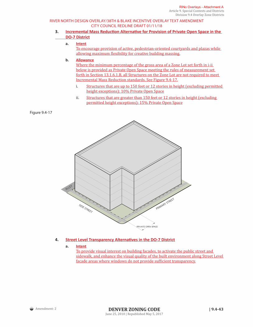
Article 9. Special Contexts and DistrictsDivision 9.4 Overlay Zone Districts
| 9.4-43 DENVER ZONING CODEJune 25, 2010 | Republished May 5, 2017
3. Incremental Mass Reduction Alternative for Provision of Private Open Space in the DO-7 District
a. IntentTo encourage provision of active, pedestrian-oriented courtyards and plazas while allowing maximum flexibility for creative building massing.
b. AllowanceWhere the minimum percentage of the gross area of a Zone Lot set forth in i-ii below is provided as Private Open Space meeting the rules of measurement set forth in Section 13.1.6.1.B, all Structures on the Zone Lot are not required to meet Incremental Mass Reduction standards. See Figure 9.4-17.i. Structures that are up to 150 feet or 12 stories in height (excluding permitted
height exceptions): 10% Private Open Spaceii. Structures that are greater than 150 feet or 12 stories in height (excluding
permitted height exceptions): 15% Private Open Space
Figure 9.4-17
PRIVATE OPEN SPACE
PRIMARY STREET
SIDE STREET
ALLEY
4. Street Level Transparency Alternatives in the DO-7 Districta. Intent
To provide visual interest on building facades, to activate the public street and sidewalk, and enhance the visual quality of the built environment along Street Level facade areas where windows do not provide sufficient transparency.
Amendment: 2
RIVER NORTH DESIGN OVERLAY/38TH & BLAKE INCENTIVE OVERLAY TEXT AMENDMENTCITY COUNCIL REDLINE DRAFT 01/11/18
RiNo Overlays - Attachment A

Article 9. Special Contexts and DistrictsDivision 9.4 Overlay Zone Districts
9.4-44 | DENVER ZONING CODEJune 25, 2010 | Republished May 5, 2017
b. AllowanceThe following alternatives may be used singularly or in combination as alternatives to a required transparency standard in the DO-7 district and may count toward required transparency no more than as described in the table below, provided all alternatives meet the requirements stated in Section 13.1.6.2.A.5:
ZONE LOT LINE DESIGNATION
DISPLAY CASES AND
AUTOMATED TELLER
MACHINES (MAX)
WALL DESIGN ELEMENTS (MAX)
PERMANENT OUTDOOR
EATING / SERVING AR-
EAS (MAX)
PERMANENT ART (MAX)
COMBINATION OF ALTERNA-TIVES (MAX)
Primary Street 0% 50% 0% 50% 80%
Primary Street B 0% 50% 0% 50% 80%
Side Street 0% 50% 0% 50% 80%
H. Vehicle Parking Exception for Transit Oriented Development in the DO-7 Districta. Intent
To promote multi-modal transportation options near major transit investments and provide flexibility for development with reduced automobile orientation.
b. Applicabilityi. The vehicle parking exception set forth below shall apply all to all uses
located within the boundary of this DO-7 district that are also located within 1/2 mile of the outer boundary of the Rail Transit Station Platform at the 38th and Blake commuter rail station.
ii. All distance and spacing requirements shall be measured according to the rule of measurement found in Section 13.1.10 Measurement of Separation or Distance.
c. Exemption Allowedi. All uses in the area described by Section 9.4.5.11.H.b.i shall be exempt from
providing the minimum amount of vehicle parking otherwise required by this Code.
ii. Minimum bicycle parking requirements set forth in the Underlying Zone District shall apply.
d. Relationship to Maximum Vehicle Surface Parking for Transit Oriented DevelopmentWhere Section 10.4.4.4 Maximum Vehicle Surface Parking for Transit Oriented Development applies, maximum parking standards shall apply, based on the mini-mum amount of parking set forth in the Underlying Zone District for such use or structure absent any exemption or reduction.
Amendment: 2
RIVER NORTH DESIGN OVERLAY/38TH & BLAKE INCENTIVE OVERLAY TEXT AMENDMENTCITY COUNCIL REDLINE DRAFT 01/11/18
RiNo Overlays - Attachment A

Article 9. Special Contexts and DistrictsDivision 9.4 Overlay Zone Districts
| 9.4-45 DENVER ZONING CODEJune 25, 2010 | Republished May 5, 2017
SECTION 9.4.6 INCENTIVE OVERLAY DISTRICTS (IO-)9.4.6.1 General Purpose
Incentive Overlay Districts are intended to serve one or more of the following purposes:
A. Provide flexibility in zoning standards for projects that deliver specified community or citywide benefits beyond what is required by the Denver Zoning Code and other regulations, including, but not limited to:
1. Affordable housing;
2. Community amenities;
3. Cultural facilities; or
4. Publicly-accessible open space.
B. Incentivize provision of community benefits specified in an adopted neighborhood or small area plan that sets forth community priorities and is adopted as part of the Comprehensive Plan.
C. Incentivize provision of community benefits that are not attainable through other requirements or programs.
D. Provide clear and predictable development outcomes.
9.4.6.2 Minimum Requirements for EstablishmentIn addition to the minimum criteria for official map amendment applications specified in Section 12.4.10 Official Map Amendment (Rezoning), an application for a rezoning to apply an Incentive Overlay District shall comply with the following provisions:
A. Application RequirementsAn application to rezone to an Incentive Overlay District shall include, in addition to other sub-mittal requirements, the following information:
1. A statement of purpose and an explanation of how the review criteria stated in Section 9.4.6.2.B are met.
2. A map indicating the boundaries of all lots located within the proposed Incentive Over-lay District and the Underlying Zone Districts contained within the proposed Incentive Overlay District.
B. Review Criteria for Approval of DistrictIn addition to the review criteria applicable to rezonings stated in Section 12.4.10, Official Map Amendment (Rezoning), and to text amendments stated in Section 12.4.11 Text Amendment, the Incentive Overlay District shall meet the following criteria:
1. Application of an Incentive Overlay District will provide community benefits that further one or more adopted city policies; and
2. Such community benefits have been determined by the City to be best achieved though incentives, rather than requirements; and
3. Application of an Incentive Overlay District will ensure clear and predictable outcomes consistent with the applicable neighborhood context, building forms, and the stated pur-pose and intent of the applicable zone district; and
4. Application of an Incentive Overlay District will apply equally to all similar properties in an area or district to provide equitable outcomes consistent with adopted City policies.
Amendment: 2
RIVER NORTH DESIGN OVERLAY/38TH & BLAKE INCENTIVE OVERLAY TEXT AMENDMENTCITY COUNCIL REDLINE DRAFT 01/11/18
RiNo Overlays - Attachment A

Article 9. Special Contexts and DistrictsDivision 9.4 Overlay Zone Districts
9.4-46 | DENVER ZONING CODEJune 25, 2010 | Republished May 5, 2017
9.4.6.3 Modification of Underlying Zone District StandardsA. Modification of Permitted Uses
1. An Incentive Overlay District shall not modify uses permitted in the Underlying Zone District.
2. An Incentive Overlay District may modify use limitations otherwise applicable to permit-ted uses in the Underlying Zone District.
B. Modification of Standards
1. An Incentive Overlay District may modify building form standards and general design standards otherwise applicable in the Underlying Zone District to incentivize specified community benefits. Allowed modifications include, but are not limited to:a. Increased building height; and/orb. Increased floor area; and/orc. Reduced setbacks; and/ord. Reduced minimum vehicular parking.
2. An Incentive Overlay District shall not introduce new building form standards or general design standards that are not applicable in the Underlying Zone District. However, the adoption of an Incentive Overlay District may be accompanied by the adoption of a Con-servation Overlay District or Design Overlay District that includes the introduction of new building form standards and/or general design standards.
9.4.6.4 Incentive Overlay Districts EstablishedThe following Incentive Overlay Districts are established:
INCENTIVE OVERLAY DISTRICT NAME ZONING MAP DESIGNATOR
38th and Blake Station Area Incentive Overlay IO-1
9.4.6.5 Effect of ApprovalA. Official Map Designator
Each Incentive Overlay District shall be shown on the official map by an “IO-#“ designator and an appropriate number placed after the Underlying Zone District designation.
B. Limitation on Permit IssuanceNo building permit for development within an Incentive Overlay District shall be issued by the City unless the development meets the standards set forth in the adopted Incentive Overlay District, any applicable incentive requirements set forth in the Denver Revised Municipal Code (D.R.M.C) and any applicable approved Rules and Regulations. Coordination with, and approval from other City agencies, such as the Office of Economic Development, may be required prior to permit issuance in an Incentive Overlay District.
Amendment: 2
RIVER NORTH DESIGN OVERLAY/38TH & BLAKE INCENTIVE OVERLAY TEXT AMENDMENTCITY COUNCIL REDLINE DRAFT 01/11/18
RiNo Overlays - Attachment A

Article 9. Special Contexts and DistrictsDivision 9.4 Overlay Zone Districts
| 9.4-47 DENVER ZONING CODEJune 25, 2010 | Republished May 5, 2017
9.4.6.6 38th and Blake Station Area Incentive Overlay District (IO-1)A. Creation
There is hereby created an Incentive Overlay District designated as the 38th and Blake Station Area Incentive Overlay District (IO-1).
B. General Purpose of Overlay District
1. Ensure that higher-intensity development in the area covered by the adopted 38th and Blake Station Area Height Amendments complements public transit investments by pro-viding specific community-benefits as recommended by the adopted plan; and
2. Implement specific adopted plan policies for the 38th and Blake Station area by requir-ing additional affordable housing and other community benefits in excess of standard requirements for development above plan-specified Base Heights; and
3. Implement an incentive-based system to that recognizes development entitlements with-in Underlying Zone Districts while allowing greater development potential for projects that provide community benefits in excess of standard requirements.
C. Applicability
1. The provisions of this IO-1 district shall apply only to those areas within Denver Zoning Code Mixed Use Commercial, Mixed Use Industrial and Residential Mixed Use Underlying Zone Districts that are designated with the IO-1 Overlay Zone District on the Official Zone Map.
2. The provisions of this IO-1 district shall apply in conjunction with applicable require-ments in D.R.M.C. Chapter 27, Article VI Incentives for Affordable Housing.
D. Maximum Base Height
1. Maximum Base Height shall be the maximum height in stories and feet set forth in the Underlying Zone District.
2. Structures that do not exceed the maximum Base Height shall not be subject to the requirements set forth in Section 9.4.6.6.F Requirements for Structures Using Incentive Height.
Amendment: 2
RIVER NORTH DESIGN OVERLAY/38TH & BLAKE INCENTIVE OVERLAY TEXT AMENDMENTCITY COUNCIL REDLINE DRAFT 01/11/18
RiNo Overlays - Attachment A

Article 9. Special Contexts and DistrictsDivision 9.4 Overlay Zone Districts
9.4-48 | DENVER ZONING CODEJune 25, 2010 | Republished May 5, 2017
E. Maximum Incentive HeightStructures that meet the requirements set forth in Section 9.4.6.6.F Requirements for Structures Using Incentive Height may exceed the maximum Base Height and instead develop to the maxi-mum Incentive Height set forth in this Section 9.4.6.6.E.
1. Maximum Incentive Height Mapa. For properties in the IO-1 district, Incentive Height maximums are set forth on the map
in Figure 9.4-18, except where height transitions are required by Section 9.4.6.6.E.2. b. Community Planning and Development shall maintain a detailed map for applica-
tion of Incentive Height to specific Zone Lots.Figure 9.4-18
Stories16
12
8
5
3
16
1216*
12*
12*3
8
55*
12*8*
8*
12
3 5 8
12 38TH ST
44TH ST
E 40TH AVE
E 39TH AVE
E 38TH AVEN LAFAYETTE ST
E 44TH AVE
E 45TH AVE
E 46TH AVEI-70
I-70
N D
OW
NIN
G S
T
BLAKE ST
BLAKE ST
WAZEE ST
WYNKOOP ST
CHESTNUT PL
ALLEY
N BRIGHTO
N BLVD
WALNUT ST
LARIM
ER STARAPA
HOE ST
LAW
RENCE ST N M
ARIO
N S
T
DEN
ARG
O S
T N L
AFAY
ETTE
ST
N H
UM
BOLD
T ST
N P
EARL
ST
N P
ENN
SYLV
ANIA
ST
I-25
N F
RAN
KLIN
ST
N G
ILPI
N S
T
N W
ILLI
AMS
ST
N R
ACE
ST
N H
IGH
ST
E 36TH AVE
E 37TH AVE
E 35TH AVE
33RD ST32ND ST34TH ST
36TH ST35TH ST
31ST ST
N B
ROAD
WAY
N W
ASHI
NG
TON
ST
40TH
40TH ST
INCENTIVE HEIGHTStories (max) Feet (max)
3 45'
5 70'
8 110'
Stories16
12
8
5
3
16
1216*
12*
12* 8
55*
12*8*
12
3
58
12
38TH ST
44TH ST
40TH ST
E 40TH AVE
E 39TH AVE
E 38TH AVEN LAFAYETTE ST
E 44TH AVE
E 45TH AVE
E 46TH AVEI-70
I-70
N D
OW
NIN
G S
T
BLAKE ST
BLAKE ST
WAZEE ST
WYNKOOP ST
ALLEY
N BRIGHTO
N BLVD
WALNUT ST
LARIM
ER STARAPA
HOE ST
LAW
RENCE ST N M
ARIO
N S
T
DEN
ARG
O S
T
N L
AFAY
ETTE
ST
N H
UM
BOLD
T ST
N P
EARL
ST
N P
ENN
SYLV
ANIA
ST
I-25
N F
RAN
KLIN
ST
N G
ILPI
N S
T
N W
ILLI
AMS
ST
N R
ACE
ST
N H
IGH
ST
E 36TH AVE
E 37TH AVE
E 35TH AVE
33RD ST32ND ST34TH ST
36TH ST35TH ST31ST ST
N B
ROAD
WAY
N W
ASHI
NG
TON
ST
N BRIGHTO
N BLVD
12 150'
16 200'
* See Section 9.4.6.6.E.2 for required height transitions
Staff Note: GIS will prepare a MapIt layer showing incentive height and transition areas but this map will be adopted in the zoning code as the official version.
Amendment: 2
RIVER NORTH DESIGN OVERLAY/38TH & BLAKE INCENTIVE OVERLAY TEXT AMENDMENTCITY COUNCIL REDLINE DRAFT 01/11/18
RiNo Overlays - Attachment A

Article 9. Special Contexts and DistrictsDivision 9.4 Overlay Zone Districts
| 9.4-49 DENVER ZONING CODEJune 25, 2010 | Republished May 5, 2017
2. Incentive Height in Transition AreasTo promote compatibility with lower-scale districts, neighborhoods or street frontages, a reduced maximum Incentive Height shall apply in transitional areas as set forth in Sec-tions a and b below. Where the provisions of both Sections a and b apply, the maximum Incentive Height shall be the lower of the applicable maximum heights. a. Height Transition Adjacent to Specific Streets
The maximum Incentive Height shall be as follows within the specified distance of a Primary or Side Street Zone Lot line fronting the following streets:
STREET DISTANCE FROM ZONE LOT LINE
MAXIMUM INCENTIVE HEIGHT
STORIES FEET
39TH AVENUE
West of Williams Street* 85’ 8 110’
LAFAYETTE STREET
West of Franklin Street* 210’ 8 110’
MARION STREET
From 300' South of Walnut Street to 36th Avenue 35’ 3 45’
LARIMER STREET
Northeast of 35th Street 135’ 12 150’
Southwest of 35th Street 135’ 5 70’
33RD STREET
Northwest of Walnut Street 175’ 8 110’
*A portion of this area may be subject to a reduced maximum Incentive Height adjacent to a Pro-tected District. See Section 9.4.6.6.E.2.b.
b. Height Transition Adjacent to a Protected DistrictThe maximum Incentive Height shall be 75 feet within 175 feet of a Protected District un-less further limited by Section 9.4.6.6.E.2.a.
F. Requirements for Structures Using Incentive Height
1. No building permit for development of a Structure exceeding Base Height within this IO-1 district shall be issued by the City unless the Structure meets the specific incentive re-quirements set forth in D.R.M.C. Chapter 27, Article VI Incentives for Affordable Housing and any applicable approved Rules and Regulations as evidenced in writing by the Office of Economic Development.
2. No building permit for development of a Structure exceeding Base Height within this IO-1 district shall be issued by the City for a Structure where the square footage of Parking Spaces or Parking Aisles located above the maximum Base Height is greater than the gross square footage of uses other than Parking Spaces or Parking Aisles located above the maximum Base Height.
Draft Note: As referenced above, a new Chapter 27, Article VI ' to follow the exist-ing Chapter 27, Article V 'Dedicated Funding for Affordable Housing' (new 2017 Article setting forth the citywide linkage fee) is proposed to provide related afford-able housing requirements.
Amendment: 2
RIVER NORTH DESIGN OVERLAY/38TH & BLAKE INCENTIVE OVERLAY TEXT AMENDMENTCITY COUNCIL REDLINE DRAFT 01/11/18
RiNo Overlays - Attachment A

Article 9. Special Contexts and DistrictsDivision 9.7 Master Planned Context
9.7-42 | DENVER ZONING CODEJune 25, 2010 | Republished May 5, 2017
SECTION 9.7.6 DESIGN STANDARD ALTERNATIVES 9.7.6.1 Required Build-To Alternatives
A. IntentTo help define the public realm and enhance the visual quality of the built environment where it is not possible to define the street and public sidewalk edge with building facades.
B. AllowanceThe following alternatives may be used singularly or in combination as alternatives to a re-quired build-to standard and may count toward the required build-to no more than as de-scribed in the table below, provided all alternatives meet the requirements stated in Section 13.1.5.6.7.E:
REQUIRED BUILD-TO ALTERNATIVES
ZONE DISTRICT
PERMANENT OUTDOOR
PATIO SEATING (MAX INCREASE
IN BUILD-TO RANGE)
PRIVATE OPEN SPACE (MAX % OF BUILD-TO)
GARDEN WALL (MAX % OF BUILD-TO)
GARDEN WALL WITH COVERED
SEATING FOR PE-DESTRIANS (MAX % OF BUILD-TO)
PERGOLA (MAX % OF BUILD-TO)
ARCADE (MAX % OF BUILD-
TO)
COURTYARD (MAX % OF BUILD-TO)
M-RHM-RXM-MXM-IMXM-GMX
na na 25%* 30%* 30%* 100% 100%
*If used in combination with each other, the garden wall, garden wall with covered seating for pedestrians and pergola alternatives may count toward no more than 30% of required build-to.
RiNo Overlays - Attachment A

Article 10. General Design StandardsDivision 10.4 Parking and Loading
10.4-6 | DENVER ZONING CODEJune 25, 2010 | Republished May 5, 2017
B. Applicability
1. This Section 10.4.4.4 shall apply to all uses located within 1/4 mile of the outer boundary of a Rail Transit Station Platform in all zone districts except the CMP zone districts; and
2. This Section 10.4.4.4 shall apply only to limit the amount of Surface Parking.
3. If a structure or use is exempt according to Section 10.4.5 Vehicle Parking Exceptions or Section 9.4.5.11.H Vehicle Parking Exception for Transit Oriented Development in the DO-7 District, from minimum parking requirements, this subsection’s maximum parking standard shall still apply, based on the minimum amount otherwise required for such use or structure absent any exemption or reduction.
4. All distance and spacing requirements shall be measured according to the rule of mea-surement found in Section 13.1.10, Measurement of Separation or Distance.
C. Maximum Vehicle Surface Parking PermittedFor all applicable zone districts, Surface Parking spaces shall not exceed 110 percent of the minimum parking spaces required by the subject property’s zone district, except that up to 1 vehicle surface parking space per dwelling unit shall be allowed even if exceeding the 110 percent.
10.4.4.5 Location of Required Vehicle ParkingRequired vehicle parking spaces shall be located on the same zone lot as the primary use for which provided, except as allowed below:
A. As allowed in Section 10.4.5.4, Shared Vehicle Parking, or
B. Off-Site Vehicle ParkingA primary use's required vehicle parking may be located on a Zone Lot different from the Zone Lot containing the primary use (“off-site vehicle parking”), subject to compliance with the fol-lowing standards:
1. The subject Primary Use may provide off-site vehicle parking provided that the parking spaces on the off-site Zone Lot are not required vehicle parking spaces for any other Pri-mary Use(s) (See Section 10.4.5.4 Shared Vehicle Parking for that scenario).
2. Parking requirements may be met off the zone lot by ownership or a current lease of parking spaces on another zone lot and dedicated to the primary use being served. Divesting ownership or terminating lease of the required parking spaces shall result in termination of the zoning permit until the parking deficiency is remedied.
3. Off-site parking shall be located within a “walking distance” of 1,500 feet from the use served by the remote parking. “Walking distance” shall be measured from the primary entrance of the primary use served along a connection that meets ADA requirements.
RIVER NORTH DESIGN OVERLAY/38TH & BLAKE INCENTIVE OVERLAY TEXT AMENDMENTCITY COUNCIL REDLINE DRAFT 01/11/18
Amendment: 2
RiNo Overlays - Attachment A

12.4-8 |
Article 12. Zoning Procedures & EnforcementDivision 12.4 Zoning Application and Review Procedures
DENVER ZONING CODEJune 25, 2010 | Republished May 5, 2017
C. Application and Fees
1. Submittal in WritingAll applications for site development plan review shall be filed in writing with Commu-nity Planning and Development. The applicant shall pay all required fees at the same time the application is submitted. See Section 12.3.3, Submission of Applications.
2. Concurrent ApplicationsConcurrent applications may be allowed according to Section 12.3.3.9, Concurrent Ap-plications. In no case, however, shall a building permit, as applicable, be issued until the site development plan is approved and all zoning permits issued according to this Article, unless the Zoning Administrator allows an exception in writing.
D. Public Notice RequirementsInformational Notice shall be provided according to Section 12.3.4.5, Informational Notice-Gen-eral Provisions, for the following types of site development plan review applications only:
1. Site development plans where multiple primary buildings will be sited on the same zone lot in a Residential Zone District, but not including development of a tandem house build-ing form on a single zone lot. For such site development plans, written informational notice shall be given only for receipt of the application.
2. Certain construction and exceptions in the Campus Healthcare (CMP-H and CMP-H2) zone districts, as specified in Article 9, Section 9.2.3.2.3, Construction Subject to Review and Final Decision by Planning Board.
E. Review, Referral and Decision by Development Review Committee
1. The DRC shall refer the site development plan application to other affected or interested agencies for review and comment.a. For proposed development in the DIA Influence Area Overlay District, the DRC shall
refer the site development plan application to the Department of Aviation for re-view. The DRC shall not approve a site development plan in the DIA Influence Area Overlay District until the Manager of the Department of Aviation, or designee, has found that the proposed development complies with the DIA Influence Area Overlay District standards in Article 9 of this Code. The Manager of Aviation shall comment within 14 days from the referral of the complete application. Non-response by the Manager of Aviation within the 14-day time period, or any extension agreed to by the DRC, shall be deemed a recommendation of approval.
b. For proposed development in an Incentive Overlay District, the DRC shall refer the site development plan application to other City agencies, such as the Office of Eco-nomic Development where an Incentive Overlay District requires agency approval for Structures using incentives.
2. If required by Section 12.4.3.3.F, Review and Final Decision by Planning Board, the DRC shall forward the site development plan application, together with the DRC's recommen-dation, to the Planning Board for the Planning Board’s review and final decision on the site development plan application.
3. The DRC shall consider the relevant comments of all interested parties, the actions taken by other agencies on the site development plan, as applicable, the recommendation by the Planning Board, as applicable, and the review criteria stated below, in approving, approv-ing with conditions, or denying a site development plan application.
4. The DRC may attach conditions to the site development plan approval reasonably neces-sary to protect the health, safety and welfare of the community and to minimize adverse impacts on adjacent properties, as authorized by this Code.
Amendment: 2
RIVER NORTH DESIGN OVERLAY/38TH & BLAKE INCENTIVE OVERLAY TEXT AMENDMENTCITY COUNCIL REDLINE DRAFT 01/11/18
RiNo Overlays - Attachment A

| TOC-i DENVER ZONING CODEJune 25, 2010 | Republished May 5, 2017
Contents
ARTICLE 13. RULES OF MEASUREMENT & DEFINITIONSDIVISION 13.1 RULES OF MEASUREMENT . . . . . . . . . . . . . . . . . . . . . . . . . . . . . . . . . 13.1-1
Section 13.1.1 Introduction . . . . . . . . . . . . . . . . . . . . . . . . . . . . . . . . . . . . . . . . . . . . . . . . . . . . . .13.1-1Section 13.1.2 Height for all SU, TU, TH, RH, E-MU-2.5, MU-3, and RO-3 Zone Districts. . . . . .13.1-1Section 13.1.3 Height for all Other Zone Districts . . . . . . . . . . . . . . . . . . . . . . . . . . . . . . . . . . . . .13.1-8Section 13.1.4 Other Height Rules . . . . . . . . . . . . . . . . . . . . . . . . . . . . . . . . . . . . . . . . . . . . . . . .13.1-16Section 13.1.5 Siting Form Standards . . . . . . . . . . . . . . . . . . . . . . . . . . . . . . . . . . . . . . . . . . . . .13.1-21Section 13.1.6 Design Element Form Standards . . . . . . . . . . . . . . . . . . . . . . . . . . . . . . . . . . 13.1-4951Section 13.1.7 Fence and Wall Height Measurement . . . . . . . . . . . . . . . . . . . . . . . . . . . . . . 13.1-7077Section 13.1.8 Rooftop mechanical Equipment Screening Measurement . . . . . . . . . . . . . 13.1-7077Section 13.1.9 Measurement of Motor Vehicle or Trailer Length . . . . . . . . . . . . . . . . . . . . 13.1-7178Section 13.1.10 Measurement of Separation or Distance . . . . . . . . . . . . . . . . . . . . . . . . . . . 13.1-7178
DIVISION 13.2 RULES OF INTERPRETATION . . . . . . . . . . . . . . . . . . . . . . . . . . . . . . . 13.2-1DIVISION 13.3 DEFINITIONS OF WORDS, TERMS & PHRASES . . . . . . . . . . . . . . . . . 13.3-1
RiNo Overlays - Attachment A

| 13.1-21
Article 13. Rules of Measurement & DefinitionsDivision 13.1 Rules of Measurement
DENVER ZONING CODEJune 25, 2010 | Republished May 5, 2017
SECTION 13.1.5 SITING FORM STANDARDS13.1.5.1 Zone Lot Size and Width
A. Zone Lot Size (Min)
1. Rule of MeasurementZone lot size is the total area within a property’s zone lot lines, excluding adjacent or abutting right-of-way. See Figure 13.1-32.
PRIMARY STREET
ALLEY
Zone Lot Total Area
Figure 13.1-32
B. Zone Lot Width
1. Rule of MeasurementZone lot width is the distance between the zone lot lines intersecting the Primary Street zone lot line, measured along the required minimum primary street setback line. See Figures 13.1-33 and -34.
PRIMARY STREET
Primary Street Setback
Side Zone Lot Line
Side
Zon
e Lo
t Lin
e
Zone Lot Width
Primary Street Setback
PRIMARY STREET
Zone Lot Line
Zone Lot Line
Zone Lot Width
Primary Street
Zone Lot Line
ALLEY
Figure 13.1-33 Figure 13.1-34
C. Zone Lot Width in the DO-7 Overlay District
1. Rule of MeasurementIn lieu of the rule of measurement set forth in Section 13.1.5.1.B, Zone Lot Width in the DO-7 district shall be the distance between the Zone Lot Lines intersecting the Primary Street Zone Lot Line measured along the Primary Street Zone Lot Line. For Zone Lots with multiple Primary Street Zone Lot Lines, the Primary Street Zone Lot Line with the greatest length will used to determine Zone Lot Width.
Amendment: 2
RIVER NORTH DESIGN OVERLAY/38TH & BLAKE INCENTIVE OVERLAY TEXT AMENDMENTCITY COUNCIL REDLINE DRAFT 01/11/18
RiNo Overlays - Attachment A

| 13.1-37
Article 13. Rules of Measurement & DefinitionsDivision 13.1 Rules of Measurement
DENVER ZONING CODEJune 25, 2010 | Republished May 5, 2017
13.1.5.6 Determination of Primary Street, Side Street, Side Interior, and Rear Zone Lot Lines in the DO-7 Overlay District
A. IntentTo provide a reference of measurement for standards related to form and building placement while promoting pedestrian-oriented frontages and an active riverfront experience with visual interest and variety in the DO-7 district.
B. General RequirementsThe general requirements set forth for all CC, MX, and MS Zone Districts in Section 13.1.5.4.B General Requirements shall apply in addition to the requirements set forth in this Section 13.1.5.6.
C. Criteria for Zoning Administrator DeterminationsFor all Underlying Zone Districts, the Zoning Administrator shall designate a Zone Lot’s Primary Street, Side Street, Side Interior and Rear Zone Lot Lines, as applicable, based on an analysis of the provisions set forth in Section 13.1.5.4.C Criteria for Zoning Administrator Determinations, except that:
1. In lieu of the provisions set forth in Section 13.1.5.4.C.2.a, the Zoning Administrator may designate more than one Primary Street Zone Lot Line in any Underlying Zone District where:a. Guidance provided in any applicable General Development Plan, regulating plan,
and/or Urban Design Standards and Guidelines, such as designation of pedestrian priority streets in such plan, indicates the need for designation of multiple Primary Streets.
b. The Blueprint Denver Street Classification of all Abutting streets, per the table in Section 13.1.5.4.C.2.b indicates Primary Street designation for more than one Abut-ting street.
2. The Zoning Administrator shall designate Zone Lot Lines that Abut named streets (such as Wynkoop and Larimer streets) as Primary Street Zone Lot Lines, except that:a. Any Zone Lot Line that is Adjacent to 35th Street shall also be designated as a Pri-
mary Street Zone Lot Line in addition to the named street. b. Where a corner Zone Lot Abuts more than one named street, the Zoning Admin-
istrator may elect to designate only one of the named streets as a Primary Street based on an analysis of the Blueprint Denver Street Classification of each named street.
3. Any Zone Lot Line that Abuts, and is roughly parallel to, the South Platte River, or a Street that is Adjacent to the South Platte River, shall be designated as a Primary Street Zone Lot Line. See Figure 13.1-57.
4. Any Zone Lot Line that Abuts a Public Park shall be designated as a Side Street Zone Lot Line.
D. Corner Zone Lot, Double Frontage Zone Lot, or Zone Lot with Frontage 3 or More StreetsIn lieu of the provisions set forth in Sections 13.1.5.4.E-G, the Zoning Administrator shall desig-nate a Zone Lot's Primary Street, Side Street, Side Interior and Rear Zone Lot Lines, as appli-cable according to the criteria set forth in Section 13.1.5.6.C. See Figure 13.1-57.
Amendment: 2
RIVER NORTH DESIGN OVERLAY/38TH & BLAKE INCENTIVE OVERLAY TEXT AMENDMENTCITY COUNCIL REDLINE DRAFT 01/11/18
RiNo Overlays - Attachment A
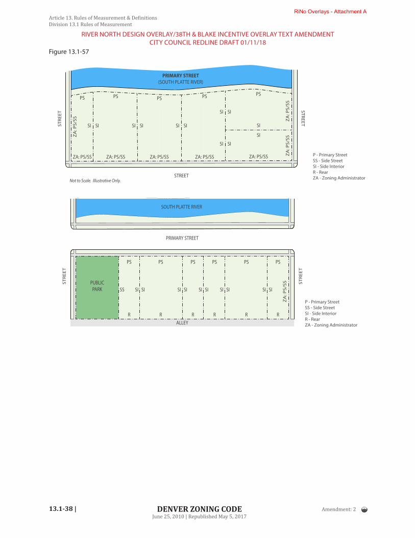
13.1-38 |
Article 13. Rules of Measurement & DefinitionsDivision 13.1 Rules of Measurement
DENVER ZONING CODEJune 25, 2010 | Republished May 5, 2017
Figure 13.1-57
P - Primary StreetSS - Side StreetSI - Side InteriorR - RearZA - Zoning AdministratorSTREET
PRIMARY STREET(SOUTH PLATTE RIVER)
ZA: PS/SS
ZA
: PS/
SS
ZA: PS/SS
PSPS
ZA: PS/SS
PS
ZA
: PS/
SSZ
A: P
S/SS
SI
SI
ZA: PS/SS ZA: PS/SS
PS PS
SI SI SI SI
SI SI
SI SI
SI SISTRE
ET
STREET
Not to Scale. Illustrative Only.
P - Primary StreetSS - Side StreetSI - Side InteriorR - RearZA - Zoning Administrator
PRIMARY STREET
ALLEY
PUBLICPARK
PSPS PS
ZA
: PS/
SS
PS PS PS
SISI SISISS SISI SISI SISI
STR
EET
STR
EET
RR RR R R
Not to Scale. Illustrative Only.
SOUTH PLATTE RIVER
Amendment: 2
RIVER NORTH DESIGN OVERLAY/38TH & BLAKE INCENTIVE OVERLAY TEXT AMENDMENTCITY COUNCIL REDLINE DRAFT 01/11/18
RiNo Overlays - Attachment A
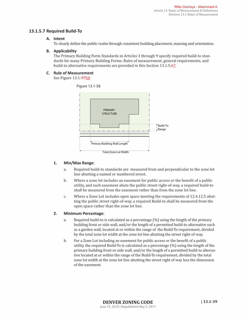
| 13.1-39
Article 13. Rules of Measurement & DefinitionsDivision 13.1 Rules of Measurement
DENVER ZONING CODEJune 25, 2010 | Republished May 5, 2017
13.1.5.7 Required Build-ToA. Intent
To clearly define the public realm through consistent building placement, massing and orientation.
B. ApplicabilityThe Primary Building Form Standards in Articles 3 through 9 specify required build-to stan-dards for many Primary Building Forms. Rules of measurement, general requirements, and build-to alternative requirements are provided in this Section 13.1.5.67.
C. Rule of Measurement See Figure 13.1-5758
Total Zone Lot Width
Primary Building Wall Length
Build-To Range
PRIMARY STRUCTURE
Figure 13.1-58
1. Min/Max Range:a. Required build-to standards are measured from and perpendicular to the zone lot
line abutting a named or numbered street.b. Where a zone lot includes an easement for public access or the benefit of a public
utility, and such easement abuts the public street right-of-way, a required build-to shall be measured from the easement rather than from the zone lot line.
c. Where a Zone Lot includes open space meeting the requirements of 12.4.12.5 abut-ting the public street right-of-way, a required Build-to shall be measured from the open space rather than the zone lot line.
2. Minimum Percentage:a. Required build-to is calculated as a percentage (%) using the length of the primary
building front or side wall, and/or the length of a permitted build-to alternative such as a garden wall, located at or within the range of the Build-To requirement, divided by the total zone lot width at the zone lot line abutting the street right-of-way.
b. For a Zone Lot including an easement for public access or the benefit of a public utility, the required Build-To is calculated as a percentage (%) using the length of the primary building front or side wall, and/or the length of a permitted build-to alterna-tive located at or within the range of the Build-To requirement, divided by the total zone lot width at the zone lot line abutting the street right of way less the dimension of the easement.
RiNo Overlays - Attachment A

| 13.1-41
Article 13. Rules of Measurement & DefinitionsDivision 13.1 Rules of Measurement
DENVER ZONING CODEJune 25, 2010 | Republished May 5, 2017
Figure 13.1-60
2. Private Open SpacePrivate Open Space shall comply with the following standards: a. Private Open Space used as a build-to alternative in any zone district:
i. Shall be open to the skyii. Shall not be covered by an Off-Street Parking Area or a Completely or Par-
tially Enclosed Structure, but may include Open Structures excluding Exterior Balconies
iii. May include tables, chairs, benches, sculptures and similar elementsiv. May include the operation of any unenclosed primary, accessory, or tempo-
rary uses permitted in the zone districtv. Shall be fully visible from a primary streetvi. Shall not be permanently enclosed by railings, fences, gates, or walls that do
not allow public access during business hours.b. Private Open Space used as a build-to alternative in a C-CCN zone district shall
contain at least one Minimum Contiguous Area meeting the requirements of Section 13.1.6.1.B.3.b.vii
3. Garden WallA garden wall shall comply with all of the following standards:a. Garden Walls must be between 30 inches and 42 inches in height with the following
exceptions: i. Decorative and/or structural piers may exceed 42 inches in height.ii. Seating incorporated into the wall may be a minimum of 18 inches in height
and may be accessed from both sides of the wall without an intervening divi-sion.
iii. Pergola, awning and trellis structures must maintain clear visual sight lines be-tween the public right of way and the property between the heights of 42 inches and 84 inches.
RiNo Overlays - Attachment A

| 13.1-45
Article 13. Rules of Measurement & DefinitionsDivision 13.1 Rules of Measurement
DENVER ZONING CODEJune 25, 2010 | Republished May 5, 2017
Figure 13.1-64
13.1.5.8 Setbacks A. Intent
To provide adequate separation for privacy and access to sunlight.
B. Rules of MeasurementSetbacks provide a minimum horizontal distance between a zone lot line and the location of uses and structures on a zone lot, measured as follows: See Figure 13.1-6465
1. Primary and Side Street setbacks are measured perpendicular to the zone lot line at the edge of the right-of-way abutting a name or numbered street or an easement for public access Abutting the right-of-way of a named or numbered street.
2. Side Interior and Rear setbacks are measured perpendicular to the side interior or rear zone lot line abutting another zone lot, a public alley, or an easement for public access Abutting an Alley.
3. Where a Side Interior setback standard is stated as “min one side/min combined:”a. One side interior setback shall meet the standard meeting the “min one side” and
the total of both side interior setbacks shall be equal to or greater than the standard of the “min combined.”
b. If zone lot has only one Side Interior Zone Lot Line, the “min one side” standard shall apply.
4. Primary street and rear setbacks extend across the full width of the zone lot, overlapping with the side interior and side street setbacks as applicable.
5. Side interior and side street setbacks extend the full length of the side zone lot lines, over-lapping with both the primary street and rear setbacks.
RiNo Overlays - Attachment A

13.1-46 |
Article 13. Rules of Measurement & DefinitionsDivision 13.1 Rules of Measurement
DENVER ZONING CODEJune 25, 2010 | Republished May 5, 2017
PRIMARY STREET
SIDE STREET
Rear Setback
Side Street Setback
Primary Street Setback
Side Interior Setback
Figure 13.1-65
PRIMARY STREET SIDE STREET
Primary Street Setback
Side Street Setback
Side
Inte
rior S
etba
ck
Rear Setback
13.1.5.9 Residential SetbacksA. Intent
To provide transitional space between the edge of a public sidewalk and dwelling units located at the Street Level
B. ApplicabilityResidential setback standards apply to the portion of a Structure that contains street-facing dwelling units at the Street Level.
C. Rules of Measurement
1. Residential Setbacks are measured perpendicular to the Zone Lot Line at the edge of the right-of-way Abutting a named or numbered street or an easement for public access Abutting the right-of-way of a named or numbered street.
2. Residential Setbacks are measured from the Primary or Side Street Zone Lot Line to the outside wall of any street-facing dwelling unit. See Figure 13.1-66.
3. Portions of a Structure containing residential lobbies, rental offices, amenity areas or nonresidential uses shall not be subject to a Residential Setback.
4. Residential Setbacks shall be considered to be a Primary Street setback for purposes of allowed encroachments.
Amendment: 2
RIVER NORTH DESIGN OVERLAY/38TH & BLAKE INCENTIVE OVERLAY TEXT AMENDMENTCITY COUNCIL REDLINE DRAFT 01/11/18
RiNo Overlays - Attachment A

| 13.1-47
Article 13. Rules of Measurement & DefinitionsDivision 13.1 Rules of Measurement
DENVER ZONING CODEJune 25, 2010 | Republished May 5, 2017
Figure 13.1-66
Not to Scale. Illustrative Only.
PRIMARY STREETSIDE STREET
DWELLING UNITS
RESIDENTIALSETBACK
DWELLING UNITS
DWELLING UNITS
RESIDENTIALSETBACK
DWELLING UNITS
ALLEY
13.1.5.10 Setback EncroachmentsA. Rule of Measurement
1. Each setback encroachment shall be measured from the required minimum setback line.
2. Setback encroachments are not cumulative in that they are always measured from the same point.
3. The entirety of the element permitted as an encroachment shall be within the permitted encroachment distance. See Figure 13.1-6567
PRIMARY STREET
SIDE STREET
Allowed EncroachmentDistance
minimum setback lin
eminim
um setback line
minimum setback line
minimum setback line
Figure 13.1-67
Amendment: 2
RIVER NORTH DESIGN OVERLAY/38TH & BLAKE INCENTIVE OVERLAY TEXT AMENDMENTCITY COUNCIL REDLINE DRAFT 01/11/18
RiNo Overlays - Attachment A

13.1-48 |
Article 13. Rules of Measurement & DefinitionsDivision 13.1 Rules of Measurement
DENVER ZONING CODEJune 25, 2010 | Republished May 5, 2017
13.1.5.11 Building CoverageA. Intent
To provide openness on a lot by limiting the amount of area buildings can cover.
B. Rule of MeasurementBuilding coverage shall be measured as the “gross area of a footprint” on the zone lot according to C below, divided by the total gross square foot area of the Zone Lot and multiplied times 100, as building coverage is expressed as a percentage.
C. Gross Area of FootprintFor purposes of building coverage, “gross area of a footprint” shall include: See Figure 13.1-6668
1. The gross area of the actual footprint measured to the exterior faces of the structure and any enclosed projections beyond the footprint of all Primary and/or Accessory:a. Structure, Completely Enclosed;b. Structure, Partially Enclosed;c. Deck, Raised; andd. Balcony, Exterior.
D. Building Coverage ExceptionsExceptions to building coverage are permitted by Neighborhood Context. See Articles 3-9, Design Standard Exceptions section.
PRIMARY STREET
SID
E S
TREE
T
PRIMARYSTRUCTUREGROSS AREA
ACCESSORYSTRUCTUREGROSS AREA
PRIMARYSTRUCTUREGROSS AREA
PRIMARYSTRUCTUREGROSS AREA
ACCESSORYSTRUCTUREGROSS AREA
ACCESSORYSTRUCTUREGROSS AREA
Figure 13.1-68
13.1.5.12 Building SeparationA. Intent
To provide a sense of openness.
B. Rule of Measurement
1. For purposes of building coverage exception contained within Articles 3-9, Design Stan-dard Exceptions: See Figure 13.1-6769a. Building separation shall be measured as the horizontal distance between the two
closest portions of each subject structure, provided each subject structure meets one of the following definitions (see Article 13 for definitions): i. Structures, Completely Enclosedii. Structures, Partially Enclosed
RiNo Overlays - Attachment A

| 13.1-49
Article 13. Rules of Measurement & DefinitionsDivision 13.1 Rules of Measurement
DENVER ZONING CODEJune 25, 2010 | Republished May 5, 2017
iii. Raised Decksiv. Balconies
b. Where another structure interrupts the separation between the two subject struc-tures, building separation shall still be considered met.
2. For all other purposes, building separation shall be measured as the horizontal distance between the two closest portions of each building’s exterior walls.
PRIMARY STREET
SID
E S
TREE
T
PRIMARYSTRUCTURE
PRIMARYSTRUCTURE
PRIMARYSTRUCTURE
ACCESSORYSTRUCTURE
ACCESSORYSTRUCTURE
ACCESSORYSTRUCTURE
Build
ing
Sepa
ratio
n
Build
ing
Sepa
ratio
n
Build
ing
Sepa
ratio
n
Build
ing
Sepa
ratio
n
Figure 13.1-69
13.1.5.13 Parking and Drive Lot Coverage in Primary Street SetbackA. Rule of Measurement
Parking and drive lot coverage in the primary street setback is measured as the total amount of material used for vehicle access or vehicle storage within the primary street setback area of a zone lot. See Figure 13.1-6870.
SID
E ST
REET
PRIMARY STREET
Primary Street Setback
Coverage not within Primary Street Setback
Coverage within Primary Street Setback
Figure 13.1-70
RiNo Overlays - Attachment A

13.1-50 |
Article 13. Rules of Measurement & DefinitionsDivision 13.1 Rules of Measurement
DENVER ZONING CODEJune 25, 2010 | Republished May 5, 2017
13.1.5.14 Surface Parking Between Building and Primary Street/Side StreetA. Rule of Measurement
For the purposes of determining if an area is between a Building and a Primary Street/Side Street, extend a line perpendicular from the Primary or Side Street Zone Lot Line. If any por-tion of said line touches the Building Facade, then said line is between the Building and such Street. See Figure 13.1-6971.
Not to Scale. Illustrative Only.
PRIMARY STREET
ALLEY
SIDE STREET
SIDE STREET
PRIMARY STRUCTURE PRIMARY
STRUCTUREPRIMARY
STRUCTURE
BetweenNot Between
Between
Not Betw
een
Between
Not Betw
een
Between Between
BETWEEN A BUILDING AND A STREET
Figure 13.1-71
13.1.5.15 Floor Area Ratio (FAR)A. Rule of Measurement - FAR
Floor area ratio (FAR) is the ratio of gross floor area of a building to the area of the zone lot on which the building is located. For example, 43,560 square feet of building on one acre of land (43,560 sq. ft.) would equal a 1:1 floor area ratio. See Figure 13.1-7072
B. Calculation of Gross Floor Area For purposes of calculating FAR, “gross floor area” means the sum of the gross horizontal areas of the several floors of a building, including interior balconies and mezzanines, but excluding exterior balconies. All horizontal dimensions of each floor are to be measured by the exterior faces of walls of each such floor. The floor area of a building shall include the floor area of ac-cessory buildings on the same zone lot, measured the same way. In computing gross floor area there shall be excluded the following:
1. Any floor area devoted to mechanical equipment serving the building, provided that the floor area of such use occupies not less than 75 percent of the floor area of the story in which such mechanical equipment is located;
2. Any floor area in a story in which the floor above is less than 6 feet above the finished grade for more than 50% of the total building perimeter;
3. Any floor area used exclusively as parking space for motor vehicles; and
RiNo Overlays - Attachment A

| 13.1-51
Article 13. Rules of Measurement & DefinitionsDivision 13.1 Rules of Measurement
DENVER ZONING CODEJune 25, 2010 | Republished May 5, 2017
4. Any floor area that serves as a pedestrian mall or public access way to shops and stores.
5. For purposes of calculating parking amounts, see rule provided in Article 10, Division 10.4 Parking and Loading.
1:1 FAR
Full lot 1/2 lot 1/4 lot
1/8 lot
1/16 lot
1:1 FAR 1:1 FAR 1:1 FAR 1:1 FAR
Figure 13.1-72
SECTION 13.1.6 DESIGN ELEMENT FORM STANDARDS
The design element form standards of this Code are defined and measured as set forth below.
13.1.6.1 Building ConfigurationA. Front or Side Wall Length / Overall Structure Length
The length of the front or side wall of a structure, or the overall structure length, shall be measured along the primary or side street zone lot line for the entire length of the structure, as shown in Figure 13.1-7173 below.
Wall LengthStructure Length
Wall Length
Wall
LengthStru
cture LengthWall
Length
Figure 13.1-73
B. Private Open Space for Cherry Creek Open Space Building Forms
1. IntentTo create quality privately owned open spaces that are adjacent and physically open to the street. Private open space should provide visual interest and activate the pedestrian realm.
2. ApplicabilityThis section applies to zone lots in the C-CCN zone districts where Primary Building Form Standards or Overlay District Standards specify a minimum percentage of Private Open Space.
Amendment: 2
RIVER NORTH DESIGN OVERLAY/38TH & BLAKE INCENTIVE OVERLAY TEXT AMENDMENTCITY COUNCIL REDLINE DRAFT 01/11/18
RiNo Overlays - Attachment A

13.1-52 |
Article 13. Rules of Measurement & DefinitionsDivision 13.1 Rules of Measurement
DENVER ZONING CODEJune 25, 2010 | Republished May 5, 2017
3. Rules of Measurementa. For Cherry Creek Open Space building forms, Private Open Space shall be calculated as a
percentage (%) using the total area open to the sky, subject to the below requirements, divided by the total gross square footage of the zZone lLot and multiplied by 100.
b. For purposes of Private Open Space measurement for Cherry Creek Open Space building forms, the total area open to the sky:i. Shall not be covered by Off-Street Parking Area or a Completely or Partially
Enclosed Structure, but may include Open Structures excluding Exterior Balconies. Private Open Space may also include tables, chairs, benches, sculp-tures and similar elements.
ii. May include the operation of any unenclosed primary, accessory, or tempo-rary uses permitted in the zone district.
iii. Any portion of the Private Open Space within the build-to range shall count toward the required build-to percentage (see Subsection 7.3.6.1, Required Build-To Alternatives).
iv. Shall aAbut a pPrimary sStreet or Side Street zZone lLot lLine.v. Shall be fully visible from a pPrimary sStreet or Side Street.vi. Shall not be permanently enclosed by railings, fences, gates, or walls that do
not allow public access during business hours.vii. Shall contain at least one Minimum Contiguous Area, subject to the minimum
dimensions below. The width of the Minimum Contiguous Area shall be mea-sured parallel to the pPrimary sStreet or Side Street zZone lLot lLine, shown as “A” in Figure 13.1-74. The depth of the Minimum Contiguous Area shall be measured as the horizontal distance between the pPrimary sStreet or Side Street zZone lLot lLine and the closest facade of the exterior building wall fac-ing the pPrimary sStreet or Side Street, measured perpendicular to the Zone lLot lLine, shown as “B” in Figure 13.1-74.a) For zZone lLots 9,375 square feet or less, as of October 27, 2014, the
Minimum Contiguous Area shall be at least 15 feet wide and 15 feet deep.b) For zZone lLots 9,375 square feet or less as of October 27, 2014, in
the C-CCN zone districts, where the zZone lLots aAbuts the southern boundary of the 3rd Avenue right-of-way, the Minimum Contiguous Area shall be at least 15 feet wide and 15 feet deep and shall aAbut, be fully visible from, and fully accessible from the 3rd Avenue right-of-way.
c) For all other zZone lLots the Minimum Contiguous Area shall be at least 15 feet wide and 30 feet deep.
PRIMARY OR SIDE STREET
Private Open SpaceMinimum Contiguous Area
Not to Scale. Illustrative Only.
STRE
ET
ALLE
Y PRIMARY STRUCTURE
B
A
PRIMARY OR SIDE STREET
STRE
ET
ALLEY
Area not included as Private Open Space
Figure 13.1-74
Amendment: 2
RIVER NORTH DESIGN OVERLAY/38TH & BLAKE INCENTIVE OVERLAY TEXT AMENDMENTCITY COUNCIL REDLINE DRAFT 01/11/18
RiNo Overlays - Attachment A

| 13.1-53
Article 13. Rules of Measurement & DefinitionsDivision 13.1 Rules of Measurement
DENVER ZONING CODEJune 25, 2010 | Republished May 5, 2017
C. Mass Reduction
1. IntentTo sculpt building mass above the base of a building, to reduce the horizontal scale of taller buildings, to provide sun and light exposure through taller buildings, and to encour-age architectural variety.
2. Rule of Measurement see Figure 13.1-7375a. The Mass Reduction is calculated as a percentage (%) using the “gross area without
building coverage” at a height of 31 feet or the highest point of the second story, whichever is less, divided by the total gross square foot area of the zone lot and multiplied times 100. For purposes of Mass Reduction, “gross area without building coverage” shall be calculated as the gross area from all zone lot lines to the exterior faces of the following structures:i. Structure, Completely Enclosed;ii. Structure, Partially Enclosed; andiii. Balcony, Exterior.
31’/2 stories Base
Mass Reduction
Mass Reduction
PRIMARY STREET
PRIMARY STREET
ALLEY
Not to Scale. Illustrative Only.
PRIMARY STREET
Mass Reduction
PRIM
ARY
STR
EET
ALLEY
Upper Stories (above 2nd Story/31’)
2-story/31’ Base
Figure 13.1-75
b. For purposes of measuring the Mass Reduction: i. The Mass Reduction shall be open to the sky from above a height of 31 feet or
the highest point of the second story, whichever is less, except the following shall be permitted:
c. Safety Railings and Parapet Walls no taller than 4 feet; andd. Open Structures, excluding Exterior Balconies. See Figure 13.1-
7476
RiNo Overlays - Attachment A
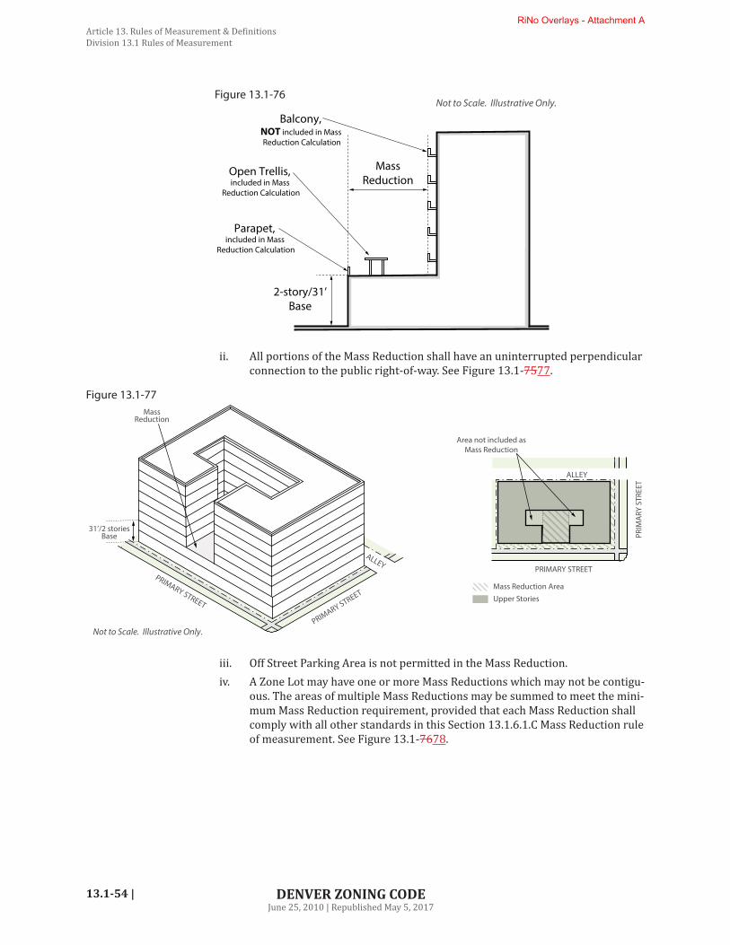
13.1-54 |
Article 13. Rules of Measurement & DefinitionsDivision 13.1 Rules of Measurement
DENVER ZONING CODEJune 25, 2010 | Republished May 5, 2017
2-story/31’Base
Mass Reduction
Parapet, included in Mass
Reduction Calculation
Open Trellis, included in Mass
Reduction Calculation
Balcony, NOT included in Mass Reduction Calculation
Not to Scale. Illustrative Only.Figure 13.1-76
ii. All portions of the Mass Reduction shall have an uninterrupted perpendicular connection to the public right-of-way. See Figure 13.1-7577.
PRIMARY STREET
Mass Reduction Area
PRIM
ARY
STR
EET
Upper Stories
31’/2 stories Base
Mass Reduction
PRIMARY STREET
PRIMARY STREET
ALLEY
Not to Scale. Illustrative Only.
ALLEY
Area not included as Mass Reduction
Figure 13.1-77
iii. Off Street Parking Area is not permitted in the Mass Reduction.iv. A Zone Lot may have one or more Mass Reductions which may not be contigu-
ous. The areas of multiple Mass Reductions may be summed to meet the mini-mum Mass Reduction requirement, provided that each Mass Reduction shall comply with all other standards in this Section 13.1.6.1.C Mass Reduction rule of measurement. See Figure 13.1-7678.
RiNo Overlays - Attachment A

| 13.1-55
Article 13. Rules of Measurement & DefinitionsDivision 13.1 Rules of Measurement
DENVER ZONING CODEJune 25, 2010 | Republished May 5, 2017
Mass Reduction
Mass Reduction
31’/2 stories Base
PRIMARY STREET
PRIMARY STREET
ALLEY
Not to Scale. Illustrative Only.
PRIMARY STREET
Mass Reduction
PRIM
ARY
STR
EET
ALLEY
Upper Stories (above 2nd Story/31’)
2-story/31’ Base
Figure 13.1-78
D. Incremental Mass Reduction
1. IntentTo reduce the perceived mass and scale of buildings and promote creative building de-signs.
2. ApplicabilityWhere specified in a building form table or applicable Overlay District, Incremental Mass Reduction standards apply to all Structures on a Zone Lot.
3. Rules of Measurement for Incremental Mass ReductionIncremental Mass Reduction creates a reduction in the gross floor area of Structures on a Zone Lot by requiring a minimum "gross area of mass reduction" within a specified range of Stories based on the percentage of Zone Lot Size specified in a building form table or applicable Overlay Zone District. See Figure 13.1-79.
Figure 13.1-79
Range of StoriesGROSS FLOOR AREA
Range of StoriesINCREMENTALMASS REDUCTION
SIDE STREET
PRIMARY STREET
ALLEY
3
4
5
Amendment: 2
RIVER NORTH DESIGN OVERLAY/38TH & BLAKE INCENTIVE OVERLAY TEXT AMENDMENTCITY COUNCIL REDLINE DRAFT 01/11/18
RiNo Overlays - Attachment A

13.1-56 |
Article 13. Rules of Measurement & DefinitionsDivision 13.1 Rules of Measurement
DENVER ZONING CODEJune 25, 2010 | Republished May 5, 2017
a. Calculation of Incremental Mass Reductioni. Method of Calculation
For each specified range of Stories, Incremental Mass Reduction is calculated using a percentage (%) of the Zone Lot Size multiplied by the number of Stories in the specified range, which yields the minimum "gross area of mass reduction" that must occur within the specified range of Stories.
ii. Measurement of StoriesFor purposes of Incremental Mass Reduction, specified ranges of Stories shall be measured according the method set forth in Section 13.1.2.3 Height in Stories.
iii. Measurement of "Gross Area of Mass Reduction"a) For purposes of Incremental Mass Reduction, “gross area of mass re-
duction” is any unbuilt area that would not be measured as gross floor area using the method set forth in Section 13.1.5.15.B Calculation of Gross Floor Area except as set forth in b) below.
b) In lieu of the exception set forth in Section 13.1.5.15.B.3, any enclosed floor area used exclusively as parking space for motor vehicles shall be included when calculating gross floor area for purposes of this Section 13.1.6.1.D.3 and shall not count toward "gross area of mass reduction".
iv. Calculation Examples: Incremental Mass Reduction in One Range of Storiesa) Minimum "Gross Area of Mass Reduction" Example: On a 25,000 square
foot Zone Lot, where the specified Incremental Mass Reduction is 10% for Stories 3-5 (a 3 Story range), application of the method of calcula-tion specified in Section 13.1.6.1.D.3.a.i would yield a minimum 7,500 square foot "gross area of mass reduction" ((25,000 x 3) x 0.10) = 7,500).
b) Remaining Gross Floor Area Example: The 7,500 square foot minimum "gross area of mass reduction" calculated in a) above would leave a re-maining maximum gross floor area of 67,500 square feet for Stories 3-5 (25,000 x 3 - 7,500 = 67,500) absent other standards, such as minimum Setbacks, which could reduce gross floor area.
v. Illustrated Example: Incremental Mass Reduction in Four Ranges of StoriesSee Figure 13.1-80 for examples of combined mass reduction on a 16-Story Structure with four specified ranges of Stories requiring increased Incremen-tal Mass Reduction as the Structure increases in height.
b. Location of Incremental Mass Reduction The "gross area of mass reduction" that meets a specified percentage of Incremen-tal Mass Reduction shall have an uninterrupted perpendicular connection with one or more of the following frontages. See Figure 13.1-81.i. Primary Street(s), including the South Platte Riverii. Side Street(s)iii. Public Park(s)
c. Minimum Dimensions of Areas Counting Towards Incremental Mass Reductioni. Incremental Mass Reduction may be provided in one or more areas that are
not contiguous with each other. ii. Any single area of Incremental Mass Reduction shall be a minimum of 15 feet
wide as measured along a frontage specified in Section 13.1.6.1.D.3.b Location of Incremental Mass Reduction, and a minimum of 7 feet deep as measured perpendicular to the Zone Lot Line parallel to that frontage. See Figure 13.1-82.
Amendment: 2
RIVER NORTH DESIGN OVERLAY/38TH & BLAKE INCENTIVE OVERLAY TEXT AMENDMENTCITY COUNCIL REDLINE DRAFT 01/11/18
RiNo Overlays - Attachment A

| 13.1-57
Article 13. Rules of Measurement & DefinitionsDivision 13.1 Rules of Measurement
DENVER ZONING CODEJune 25, 2010 | Republished May 5, 2017
Figure 13.1-80
GROSS FLOOR AREA
COMBINED INCREMENTAL MASS REDUCTION
Not to Scale. Illustrative Only.
STORIES 3 - 5 IncrementalMass Reduction
STORIES 6 - 8 IncrementalMass Reduction
STORIES 9 - 12 IncrementalMass Reduction
STORIES 13 - 16IncrementalMass Reduction
STORIES 6 - 8 Gross Floor Area
STORIES 9 - 12 Gross Floor Area
STORIES 13 - 16 Gross Floor Area
STORIES 3 - 5Gross Floor Area
PRIMARY STREETSIDE STREET
ALLEY
PRIMARY STREETSIDE STREET
ALLEY
STORIES 3 - 5 IncrementalMass Reduction
STORIES 6 - 8 IncrementalMass Reduction
STORIES 9 - 12 IncrementalMass Reduction
STORIES 13 - 16 IncrementalMass Reduction
STORIES 6 - 8 Gross Floor Area
STORIES 9 - 12 Gross Floor Area
STORIES 13 - 16 Gross Floor Area
STORIES 3 - 5Gross Floor Area
Gross Floor AreaIncremental Mass Reduction
Amendment: 2
RIVER NORTH DESIGN OVERLAY/38TH & BLAKE INCENTIVE OVERLAY TEXT AMENDMENTCITY COUNCIL REDLINE DRAFT 01/11/18
RiNo Overlays - Attachment A

13.1-58 |
Article 13. Rules of Measurement & DefinitionsDivision 13.1 Rules of Measurement
DENVER ZONING CODEJune 25, 2010 | Republished May 5, 2017
Figure 13.1-81
PRIMARY STREET
SIDE STREET
STRUCTURE
INCREMENTAL MASS REDUCTION Not to Scale. Illustrative Only.
Area not included asINCREMENTAL MASS REDUCTION
ALLEY
SID
E IN
TERI
OR
Figure 13.1-82
AREA
4M
ASS RED
UCTIO
NW
IDTH
STRUCTURE
INCREMENTAL MASS REDUCTION Not to Scale. Illustrative Only.
ALLEY
AREA
1 M
ASS RED
UCTIO
ND
EPTH
AREA 4INCREMENTAL MASS REDUCTION DEPTH
PRIMARY STREET
SIDE STREET A
REA 2
MA
SS REDU
CTION
DEPTH
1
2
3
4
AREA 1MASS REDUCTION
WIDTH
AREA 3MASS REDUCTION WIDTH
AREA 2MASS REDUCTION
WIDTH
AREA
3M
ASS RED
UCTIO
ND
EPTH
Amendment: 2
RIVER NORTH DESIGN OVERLAY/38TH & BLAKE INCENTIVE OVERLAY TEXT AMENDMENTCITY COUNCIL REDLINE DRAFT 01/11/18
RiNo Overlays - Attachment A

| 13.1-59
Article 13. Rules of Measurement & DefinitionsDivision 13.1 Rules of Measurement
DENVER ZONING CODEJune 25, 2010 | Republished May 5, 2017
E. Point Tower Floor Plate
1. IntentTo preserve sky exposure and encourage architectural variety by reducing the hori-zontal scale of the tower portion of a point tower building form.
2. Rule of Measurementa. Point Tower Floor Plate shall be measured as the Floor Plate of the largest
Habitable Story located above the specified height in the building form table. See Figure 13.1-7783.
Figure 13.1-83
F. Upper Story Side or Rear Setback, adjacent to Protected District
1. IntentTo provide appropriate height and massing transitions to less intensive adjoining zone districts.
2. Rule of MeasurementAn upper-story side or rear setback is measured from the side or rear zone lot line, extending to the specified height from the Base Plane and then horizontally to the specified setback distance. See Figure 13.1-7884.
G. Primary Street Upper Story Setback
1. IntentTo provide appropriate pedestrian scale, height and massing along a Primary Street.
2. Rules of Measurementa. Upper Story Setback
A minimum Primary Street Upper Story setback shall be measured from the Primary Street zone lot line, extending to the maximum specified height in feet and stories from the Base Plane and then horizontally to the specified setback distance, see Figure 13.1-7884.
b. Percentage of Zone Lot Width for an Upper Story Setback Where a minimum percentage of Zone Lot Width is specified for a Primary Street Upper Story Setback, the minimum percentage of Zone Lot Width at the Primary Street Zone Lot Line specified in the building form table shall be required to meet the minimum Upper Story Setback. See Figure 13.1-7985
RiNo Overlays - Attachment A

13.1-60 |
Article 13. Rules of Measurement & DefinitionsDivision 13.1 Rules of Measurement
DENVER ZONING CODEJune 25, 2010 | Republished May 5, 2017
Figure 13.1-84 Figure 13.1-85
c. Primary Street Wall Length Within the Upper Story Setback i. Where a maximum Primary Street Wall Length within the Upper Story Set-
back is specified, it shall be measured as the total length of walls along the Primary Street zone lot line within the specified depth of the Upper Story Setback. For example, if the minimum Primary Street Upper Story Setback is 10 feet, and the maximum Wall Length within the Upper Story Setback is 80 feet, the combined length of all walls above the Upper Story Setback height and within 10 feet of the Primary Street property line may be no more than 80 feet. See Figure 13.1-8086.
Figure 13.1-86
H. Upper Story Stepback
1. IntentTo shape building forms to reduce effect of massing on adjoining properties or along a street.
2. Rule of MeasurementUpper Story Stepback is measured as the specified vertical distance starting at the Base Plane, and then extending the specified horizontal distance from the face of the building’s lower portion, as shown in Figure 13.1-8187.
RiNo Overlays - Attachment A

| 13.1-61
Article 13. Rules of Measurement & DefinitionsDivision 13.1 Rules of Measurement
DENVER ZONING CODEJune 25, 2010 | Republished May 5, 2017
Upper Story
Stepback
Hei
ght
Hei
ght
Base Plane
Zone Lot
Figure 13.1-87
I. Limitation on Visible Parking Above Street Level
1. IntentTo minimize the visibility, and impacts of structured parking and promote visual interest on upper story building facades.
2. Rules of Measurementa. Depth of Limitation on Visible Parking Above Street Level
i. The depth of a Limitation on Visible Parking above Street Level shall be mea-sured from the exterior of the street-facing building wall. See Figure 13.1-8288. Uses that meet the Limitation on Visible Parking above Street Level shall be located within the specified depth, except as provided below.
ii. Recessed balcony/terrace areas or insets for building articulation up to 10 feet in depth shall be excluded from the Limitation on Visible Parking above Street Level. The remaining depth after recessed balcony/terrace areas and insets for building articulation are excluded shall be subject to the uses that meet the Limitation on Visible Parking above Street Level. See Figure 13.1-8288.
Figure 13.1-88
b. Percentage of Zone Lot Width for a Limitation on Visible Parking Above Street LevelThe minimum specified building form table percentage of Zone Lot Width at the Primary Street Zone Lot Line shall be required to meet the Limitation on Visible Parking above Street Level. See Figure 13.1-8389
RiNo Overlays - Attachment A

13.1-62 |
Article 13. Rules of Measurement & DefinitionsDivision 13.1 Rules of Measurement
DENVER ZONING CODEJune 25, 2010 | Republished May 5, 2017
Figure 13.1-89
J. Street-facing Courtyard Width and Depth
1. The street-facing courtyard width shall be measured as the distance between the two closest edges of the exterior walls facing each other across the courtyard, shown as “A” in Figure 13.1-8490.
2. The street-facing courtyard depth shall be measured as the horizontal distance between the primary street zone lot line and the closest facade of the exterior building wall facing the primary street, measured perpendicular to the zone lot line, shown as “B” in Figure 13.1-8490.
PRIMARY STREETSIDE STREET
A
B
Figure 13.1-90
K. Attached Garage Design Standard
1. Rule of Measurementa. Identify the portions of the Primary Street facing facade that shall constitute at least
65% of the total width of the primary structure enclosing the primary use.b. Draw a line parallel to the primary street setback line that is not forward at any
point of the 65% identified in a. above, thereby determining the maximum permit-ted attached garage projection. See Figure 13.1-8591.
RiNo Overlays - Attachment A

| 13.1-63
Article 13. Rules of Measurement & DefinitionsDivision 13.1 Rules of Measurement
DENVER ZONING CODEJune 25, 2010 | Republished May 5, 2017
Primary Street Facing Facade
Garage Projection
PRIMARY STREET65% of Width
Primary Street Setback
PRIMARY STRUCTURE
GARAGE
Figure 13.1-91
L. Street-facing Attached Garage Door Width
1. Rule of Measurementa. “Street-facing attached garage door width” is measured as the total width of all
street-facing garage doors attached to the primary building form, divided by the total width of the front facade of the primary building, or of the front facade of an individual dwelling unit, as applicable.
b. For purposes of this rule, the total width of a street-facing garage door(s) shall be measured as the linear distance between the outer edges of the door(s).
2. Determination of “Street-facing”A garage door is “street facing” if it faces a named or numbered street, which shall be determined by extending a line the width of the garage door and perpendicular to it to the zone lot boundary. If any portion of said line touches the right-of-way of a named or numbered street at the zone lot boundary then said garage door faces a named or num-bered street. See Figure 13.1-8692.
Figure 13.1-92
RiNo Overlays - Attachment A

13.1-64 |
Article 13. Rules of Measurement & DefinitionsDivision 13.1 Rules of Measurement
DENVER ZONING CODEJune 25, 2010 | Republished May 5, 2017
13.1.6.2 Street Level ActivationA. Transparency, Primary Street and Side Street
1. IntentTo provide visual interest to building facades, to activate the street and sidewalk, and to provide a safe pedestrian realm.
2. ApplicabilityThe Primary Building Form Standards in Articles 3 through 9 specify transparency stan-dards for many Primary Building Forms. Rules of measurement, window requirements, and transparency alternative requirements are provided in this Section 13.1.6.2.A.
3. Rules of Measurementa. Zone of Transparency
The Zone of Transparency is the area between 2 feet and 9 feet above the finished upper surface of the floor of the Street Level height across the entire street-facing Street Level building facade. See Figure 13.1-8793.i. A building facade is “street-facing” if it faces a name or numbered street,
which shall be determined by extending a line the width of the facade and perpendicular to it to the zone lot boundary. If any portion of said line touch-es the right-of-way of a name or numbered street at the zone lot boundary, then said facade is “street-facing.” See Figure 13.1-8894.
ii. The required amount of transparency shall be provided within the zone of transparency for the subject building, unless an exception or alternative is permitted by this Code.
b. Street Level TransparencyStreet Level transparency, primary or side street, is measured as the total amount of linear feet of windows or permitted alternatives provided within the Zone of Transparency divided by the total length of that same street-facing building facade (including any open parking structure entrances).
Amendment: 2
RIVER NORTH DESIGN OVERLAY/38TH & BLAKE INCENTIVE OVERLAY TEXT AMENDMENTCITY COUNCIL REDLINE DRAFT 01/11/18
RiNo Overlays - Attachment A

| 13.1-71
Article 13. Rules of Measurement & DefinitionsDivision 13.1 Rules of Measurement
DENVER ZONING CODEJune 25, 2010 | Republished May 5, 2017
B. Pedestrian Access
1. IntentTo provide clear, obvious connections for pedestrians between Primary Streets and pri-mary uses within buildings.
2. ApplicabilityThe Primary Building Form Standards in Articles 3 through 9 specify which type of Pe-destrian Access is required for each Primary Building Form., or Dwelling Unit. Pedestrian access requirements are provided in this Section 13.1.6.2.B.
3. Pedestrian Access RequirementsThe following are required supplemental standards for each type of Pedestrian Access:a. Entrance
i. Where required by the Primary Building Form Standards, an Entrance shall provide a clear, obvious, publicly accessible connection between the Street defined by the building form (Primary and/or Side) and the primary uses within the building.
ii. For the Garden Court, Town House, and Row House building forms, an en-trance shall be street-facing according to the standards specific to such build-ing forms in Articles 3 through 9.
iii. For all other building forms, an entrance shall be located:a) On the Primary Street facing facade; or b) Located on a Side Street facing facade but entirely within 15 feet of the
zone lot line abutting the Primary Street and provided the entrance is clearly visible from the public right-of-way. See Figure 13.1-96102.
iv. An entrance shall be one of the following three types:a) Door - An entrance on the same plane as the building facade.b) Recessed Entrance - An entrance inset behind the plane of the building
facade by no more than 15 feet.c) Corner Entrance - An angled street-facing entrance located on the cor-
ner of a building at approximately 45 degrees to the intersecting streets.
PRIMARY STREET
ALLEY
SIDE STREET
Not to Scale. Illustrative Only.
Door
Entrance within 15’of the zone lot lineabutting the Primary Street
Recessed Entrance
CornerEntrance
15’zone lot line
Figure 13.1-102
Amendment: 2
RIVER NORTH DESIGN OVERLAY/38TH & BLAKE INCENTIVE OVERLAY TEXT AMENDMENTCITY COUNCIL REDLINE DRAFT 01/11/18
RiNo Overlays - Attachment A

13.1-72 |
Article 13. Rules of Measurement & DefinitionsDivision 13.1 Rules of Measurement
DENVER ZONING CODEJune 25, 2010 | Republished May 5, 2017
b. Entry Featurei. Where required by the Primary Building Form Standards, an Entry Feature
shall signal the connection between the Primary Street and the primary uses within the building.
ii. An entry feature shall be located either on the Primary Street facing facade or be visible from the Primary Street. See Figure 13.1-97103.
iii. An entry feature shall be a Door, Gate, Front Porch, Front Stoop, Front Terrace, Canopy, and/or Arcade
PRIMARY STREET
SIDE STREET
Not to Scale. Illustrative Only.
Door
Gate
Front Porch
Front Stoop
Front Terrace
Canopy
Arcade
ALLEY
Figure 13.1-103
c. Dwelling Unit Entrance with Entry Featurei. Where required by Primary Building Form Standards or Overlay District
Standards, a Dwelling Unit Entrance with Entry Feature shall reinforce a traditional semi-public transition area between the public street frontage and individual private dwelling units.
ii. A Dwelling Unit Entrance with Entry Feature shall provide access to individu-al Street Level Dwelling Units located behind any street-facing building facade that is within 10 feet of a required Primary or Side Street Setback or Residen-tial Setback. See figure 13.1-104.
iii. Each Dwelling Unit Entrance with entry feature shall combine one of the En-trance types listed in Section 13.1.2.6.B.3.a.iv with one of the following entry features:a) A Front Porch with a minimum depth of 5 feet between the door and
Primary or Side Street Zone Lot Line, as measured perpendicular to the Zone Lot Line; or
b) A Canopy with a minimum depth of 3 feet between the door and Pri-mary or Side Street Zone Lot Line, as measured perpendicular to the Zone Lot Line.
iv. A building facade is “street-facing” if it faces a Primary or Side Street Zone Lot Line, which shall be determined by extending a line the width of the facade and perpendicular to it to the Primary or Side Street Zone Lot Line. If any por-tion of said line touches the Primary or Side Street Zone Lot Line, then said facade is “street-facing.” See Figure 13.1-94.
Draft Note: New section proposed for insertion after existing Section 13.1.6.2.B.3.b.
Amendment: 2
RIVER NORTH DESIGN OVERLAY/38TH & BLAKE INCENTIVE OVERLAY TEXT AMENDMENTCITY COUNCIL REDLINE DRAFT 01/11/18
RiNo Overlays - Attachment A

| 13.1-73
Article 13. Rules of Measurement & DefinitionsDivision 13.1 Rules of Measurement
DENVER ZONING CODEJune 25, 2010 | Republished May 5, 2017
Figure 13.1-104
Not to Scale. Illustrative Only.
PRIMARY STREETSIDE STREET
Street Level DwellingUnits
Street Level DwellingUnits
ALLEY
Dwelling Unit Entrancewith Entry Feature
Dwelling Unit Entrancewith Entry Feature
Not to Scale. Illustrative Only.
PRIMARY STREETStreet Level Dwelling Units
Subject to Entry Requirement
SIDE STREET
Street Level Dw
elling Units
Subject to Entry Requirement
ALLEY
d. Pedestrian Connectioni. Where required by the Primary Building Form Standards, a Pedestrian Con-
nection shall provide a clear, obvious, publicly accessible connection between the Primary Street and the primary uses within the building. See Figure 13.1-98105. The Pedestrian Connection shall comply with the following:a) Fully paved and maintained surface not less than 5 feet in width.b) Unit pavers or concrete distinct from the surrounding parking and drive
lane surface.c) Located either within a raised median or between wheel stops to pro-
tect pedestrians from vehicle overhangs where parking is adjacent.d) The portions of pedestrian connection that cross driveways or drive
aisles shall not exceed 25 feet in length.
Amendment: 2
RIVER NORTH DESIGN OVERLAY/38TH & BLAKE INCENTIVE OVERLAY TEXT AMENDMENTCITY COUNCIL REDLINE DRAFT 01/11/18
RiNo Overlays - Attachment A

13.1-76 |
Article 13. Rules of Measurement & DefinitionsDivision 13.1 Rules of Measurement
DENVER ZONING CODEJune 25, 2010 | Republished May 5, 2017
C. Street Level Height
1. IntentPromote Street Level designs that can be adapted to future uses and ensure that Street Level building spaces have an appropriate scale in relationship to the pedestrian realm.
2. ApplicabilityStreet Level Height shall apply to any street-facing story meeting the definition of Street Level in Section 13.3.
3. Rules of Measurementa. Street Level Height is measured from the upper surface of the floor of the Street
Level, to the upper surface of the floor or roof next above across the entire street-facing Street Level building facade for a minimum depth of 15 feet from the street-facing building facade. See Figure 13.1-108.
b. A building facade is “street-facing” if it faces a Primary or Side Street Zone Lot Line, which shall be determined by extending a line the width of the facade and perpen-dicular to it to the Primary or Side Street Zone Lot Line. If any portion of said line touches the Primary or Side Street Zone Lot Line, then said facade is “street-facing.” See Figure 13.1-94.
Figure 13.1-108
Street Level Height
Upper Surface of Floor
Upper Surface of Floor
Depth
Min StreetLevel Height
Min StreetLevel Height
4’-0”
Street Level
SIDE STREET PRIMARY STREET
SLOPE
ALLEY
SLOPE
Amendment: 2
RIVER NORTH DESIGN OVERLAY/38TH & BLAKE INCENTIVE OVERLAY TEXT AMENDMENTCITY COUNCIL REDLINE DRAFT 01/11/18
RiNo Overlays - Attachment A

| 13.3-3
Article 13. Rules of Measurement & DefinitionsDivision 13.3 Definition of Words, Terms and Phrases
DENVER ZONING CODEJune 25, 2010 | Republished May 5, 2017
BBackhaul or Backhaul Network: The lines that connect a provider’s tower/cell sites to one or more cellular telephone switching offices, and/or long distance providers, or the public switched telephone network.
Balcony, Exterior: A projecting cantilevered platform on a building that is not supported on the ground by posts, columns, or similar supporting structural members. Generally, an exterior balcony is intended to be used for outdoor living, gardening, or other actively used outdoor space. An exte-rior balcony shall not include a landing abutting an entry to habitable space, provided such landing does not exceed the minimum required dimensions for a landing as defined in the Building Code.
Base Height: the maximum Building Height established in the Underlying Zone District, including any Building Height limits associated with proximity to a Protected District, to which Structures can be constructed without meeting the additional requirements set forth in an Incentive Overlay District.
Berm: A mound of earth, or the act of pushing earth into a mound, usually for the purpose of shielding or buffering uses, or to control the direction of water flow.
Billboard: See “Outdoor General Advertising Device”.
Block: A tract of land bounded by platted streets, public parks, cemeteries, railroad rights-of-way, shore lines, or corporate boundaries of the city.
Block, Square: A block with contiguous sides, where the difference in length between the sides of the block is no greater than 50 feet.
Block, Oblong: A block with contiguous long and short sides, where the long side of the block is 50 feet or more greater in length than the short side of the block.
Block Face: See definition of “Face Block.”
Build-to: An alignment at the primary street or side street setback line of a zone lot, or within a range of setback from the zone lot line abutting a street, along which a street-facing, primary building wall must be built.
Building: Any covered structure intended for the shelter, housing or enclosure of any person, animal or chattel.
Building, Principal or Primary: A building in which is conducted the principal or primary use of the zone lot on which it is situated.
Building Form Standards: Standards applicable to the development of buildings and struc-tures in this Code which, taken together, regulate building height (Building Height Standards), building siting (Siting Standards), building design elements (Design Element Standards), and the permitted use of buildings (Use Building Form Standards).
Building Front or Frontage: That exterior wall of a building facing a front line of the zone lot.
Building Height: The height of a building, measured in accordance with the Rules of Measure-ment (see Division 13.1 of this Article.)
Building Height Standards or Height Standards: Standards in this Code that address how tall a build-ing and its component parts may be. Building height standards include, but are not limited to, standards addressing overall building height in feet or stories, side wall height, and bulk plane requirements.
Amendment: 2
RIVER NORTH DESIGN OVERLAY/38TH & BLAKE INCENTIVE OVERLAY TEXT AMENDMENTCITY COUNCIL REDLINE DRAFT 01/11/18
RiNo Overlays - Attachment A

13.3-14 |
Article 13. Rules of Measurement & DefinitionsDivision 13.3 Definition of Words, Terms and Phrases
DENVER ZONING CODEJune 25, 2010 | Republished May 5, 2017
IImpervious Material: A surface that has been compacted or covered with a layer of materi-als that is highly resistant to infiltration by water. Impervious materials include, but are not limited to, surfaces such as compacted sand, lime rock, or clay; asphalt concrete, driveways, re-taining walls, stairwells, stairways, walkways, decks and patios at grade level, and other similar structures.
Incentive Height: Additional Building Height permitted above the Base Height for develop-ment meeting the additional requirements set forth in an Incentive Overlay District.
Industrial Zone District: The Industrial A (“I-A”) and the Industrial B (“I-B”) Zone Districts, but not including the Industrial Mixed Use (“I-X” or “M-IMX”) Zone Districts established by this Code.
Involuntary Demolition or Involuntarily Destruction: The destruction or demolition of a structure caused by natural forces (e.g., accidental fire; flood; tornado) and not by man-made forces.
Amendment: 2
RIVER NORTH DESIGN OVERLAY/38TH & BLAKE INCENTIVE OVERLAY TEXT AMENDMENTCITY COUNCIL REDLINE DRAFT 01/11/18
RiNo Overlays - Attachment A

| 13.3-37
Article 13. Rules of Measurement & DefinitionsDivision 13.3 Definition of Words, Terms and Phrases
DENVER ZONING CODEJune 25, 2010 | Republished May 5, 2017
UUnderlying Zone District: The standard non-overlay zone district providing base building form and use requirements is considered to be the Underlying Zone District when used in combination with an Overlay Zone District. Underlying Zone Districts may include, but are not limited to, Residential Zone Districts and Mixed Use Commercial Zone Districts.
Unobstructed Open Space: Land with no buildings thereon, except fenced or walled trash facilities. The following provisions apply to the specified zone districts:
1. Except as otherwise provided herein, in the Single Unit (SU), Two Unit (TU), Townhouse (TH), or Rowhouse (RH) zone districts, unobstructed open space shall include any areas that are open to the sky including driveways; driving aisles; unenclosed parking spaces; front porches; and patios, decks or exterior balconies the surface of which is two and one half (2 1/2) feet or less above grade; and unenclosed areas covered by a trellis or arbor.
2. In the Single Unit (SU) and Two Unit (TU) zone districts, the following portions of the zone lot shall not be deemed to be unobstructed open space: any area bordered by walls on more than three sides; any porch, patio, or deck enclosed by any railing, wall, or similar structure in excess of three (3) feet in height above the surface of the porch, patio or deck; and any area beneath a projecting architectural or structural element such as balconies, bay windows, or second floor projections, excepting eaves.
Upper Story Setback: The horizontal distance that an upper portion of a building facade is set back from the property or zone lot boundary line.
Upper Story Step-Back: The horizontal distance that an upper portion of a building facade is set back from the face of the building’s lower portion.
Use: The purpose for which land or structures thereon is designed, arranged or intended to be occupied or used, or for which it is occupied, maintained, rented or leased.
Use, Allowed: See “Use, Permitted.”
Use, Accessory: A subordinate use, clearly incidental and related to the primary use of land, and, unless otherwise permitted by this Code, located on the same zone lot as that of the pri-mary use.
Use, By Right: See “Use, Permitted.”
Use, Compliant: A use or activity that was lawful prior to the adoption, revision, or amend-ment to this Code, but which by reason of such adoption, revision, or amendment, or because other uses are established closer to the legally established use than this Code permits, does not comply with current use limitations applicable to such use or activity.
Use, Conforming: A use or activity that was lawful when originally established and that com-plies with current use limitations applicable to the use or activity in the zone district in which it is located. A use or activity that was lawful when originally established, but which, by reason of the adoption of or revision to this Code, does not comply with a review procedure (e.g., special exception review), or with a reduceable spacing/distance requirement, or with a site develop-ment or design standard (e.g., parking, landscaping, and signage) otherwise applicable to such use, shall be classified as a “conforming use.”
Amendment: 2
RIVER NORTH DESIGN OVERLAY/38TH & BLAKE INCENTIVE OVERLAY TEXT AMENDMENTCITY COUNCIL REDLINE DRAFT 01/11/18
RiNo Overlays - Attachment A

Proposal Page 1 of 2
COMMUNITY PLANNING & DEVELOPMENT
Return completed form to [email protected] W. Colfax Ave., Dept. 205
Denver, CO 80202
720-865-2974 • [email protected]
REZONING GUIDE
Last updated: June 20, 2014
Zone Map Amendment (Rezoning) - Legislative Rezoning ProposalPROPERTY OWNER INFORMATION REPRESENTATIVE*
Property Owner Name Multiple owners Representative Name Councilman Albus Brooks - legislative rezoning
Address Address 3280 Downing Street
City, State, Zip City, State, Zip Denver, CO
Telephone Telephone 720-337-7709
Email Email [email protected]
SUBJECT PROPERTY INFORMATION
Location (address and/or boundary description): Multiple properties generally located within the River North Business Improvement District or area covered by the 38th and Blake Station Area Height Amendments. See attached map and legal descriptions. The overlays are proposed only for ap-plication to existing C-MX and I-MX districts.
Assessor’s Parcel Numbers: Multiple
Area in Acres or Square Feet: Approx. 250 acres
Current Zone Districts: Multiple
PROPOSAL
Proposed Zone Districts:Application of the DO-7 (River North Design Overlay) and IO-1 (38th and Blake In-centive Overlay) to existing underlying C-MX and I-MX zone districts and overlays. Public Review Draft of proposed DO-7 and UO-2 overlay zone districts available at: www.denvergov.org/38blake
REVIEW CRITERIA
General Review Crite-ria: The proposal must comply with all of the general review criteria
DZC Sec. 12.4.10.13
□ Consistency with Adopted Plans: The proposed official map amendment is consistent with the City’s adopted plans, or the proposed rezoning is necessary to provide land for a community need that was not anticipated at the time of adoption of the City’s Plan
Please provide an attachment describing relevant adopted plans and how proposed map amendment is consistent with those plan recommendations; or, describe how the map amendment is necessary to provide for an unantici-pated community need.
□ Uniformity of District Regulations and Restrictions: The proposed official map amendment results in regula-tions and restrictions that are uniform for each kind of building throughout each district having the same clas-sification and bearing the same symbol or designation on the official map, but the regulations in one district may differ from those in other districts.
□ Public Health, Safety and General Welfare: The proposed official map amendment furthers the public health, safety, and general welfare of the City.
RiNo Overlays - Attachment B

Proposal Page 2 of 2
COMMUNITY PLANNING & DEVELOPMENT
Return completed form to [email protected] W. Colfax Ave., Dept. 205
Denver, CO 80202
720-865-2974 • [email protected]
REZONING GUIDE
Last updated: June 20, 2014
RiNo Overlays - Attachment B

November 15, 2017
Mr. Brad Buchanan Executive Director Community Planning & Development 201 W. Colfax Avenue Denver, Colorado 80202
RE: Request for text amendments to establish the River North Design Overlay and 38th and Blake Station Area Incentive Overlays + implement the overlays through map amendments applied to properties with existing mixed-use zone districts.
As the Councilman for District 9, I am writing to request that Community Planning and Development (CPD) initiate a legislative text amendment that will establish the River North Design Overlay (DO-7) and 38th and Blake Incentive Overlay (IO-1). I am also requesting that CPD initiate a legislative map amendment to apply the DO-7 and IO-1 Overlays to the properties shown on the map below with existing mixed-use zoning.
The proposed overlays are the result of a robust 12-month process with CPD Staff, property owners and the public. Each component has been thoughtfully considered to reach a consensus on the proposed zoning. I am confident that the result of this work has ensured a zoning proposal that will conform to the recommendations of the 38th and Blake Station Area Height Amendments (2016) and further the vision for the station and wider RiNo area.
As a result, I believe there is substantial community support for this map amendment application for which I will sponsor. Please contact me with any questions at (720) 337-7709.
Sincerely,
Albus Brooks Denver City Council President District 9
Note: Please see sepa-rate attached map and legal descriptions for updated boundar-ies (reflects 12/6/17 Planning Board recommendation for map adjustments).
RiNo Overlays - Attachment B

Zone Map Amendment 17i-00121 EXHIBIT A
That the Zone Districts designated “I-MX” or “C-MX” in the Official Zoning Map of the City and County of Denver described as follows or included within the following boundaries shall be and hereby are amended to include the River North Design Overlay District Designation “DO-7”
Case and Ebert's Addition to the City of Denver Block 1 Lots 5 through 10 and 21 through 29 Block 2 Lots 17 through 21 and 25 through 32 Block 3 Lots 1 through 6 All of Block 4 Block 15 Lots 12 through 16 All of Blocks 17, 18, 19, and 20 Block 21 Lots 2 through 5 and that part of the fractional Block 4, H. Witter’s Addition, which lies between the alley in said Block 4 and in the rear of said Lots in Case and Ebert’s Addition All of Block 22 Block 23 Lots 1 through 4 and 11 through 32 All of Block 24 and 25 Block 26 Lots 1 through 16 and 21 through 32 All of Block 27 Block 28 Lots 1 through 8 and 13 through 32 Block 29 Lots 1 through 9 Block 30 Lot 5 Block 31 Lots 1 through 16 Block 32 Lots 1 through 16 Block 33 Lots 1 through 16 Block 34 Lots 1 through 16 Block 35 Lots 1 through 16 Block 36 Lots 1 through 7 and 11 through 16
RiNo Overlays - Attachment B

Block 37 Lots 1 through 16
CURTIS AND CLARKES ADDITION TO THE CITY OF DENVER Block 55 Lots 26 through 32 Block 59 Lots 1 through 16 Block 60 Lots 1 through 10
Denargo Market Subdivision Filing No. 2 Block 1 Lot 1
H. Witter's Addition to Denver ColoradoBlock 1Lots 29 through 32Block 5Lots 1 through 4Block 7Lots 1 through 12
PLATTE ADDITION TO DENVER Block 55 Lots 26 through 32
Together with the following properties known as:
Parcel Schedule Number Site address Deed recorded at Reception Number 0227400093000 2901 BROADWAY 2014113780 0227500032000 2950 ARKINS CT 2014004588 0227500033000 1901 29TH ST 2001218957 0227500087000 3060 BRIGHTON BLVD 2012114611 0227500119000 3001 BRIGHTON BLVD 2016055578 0227500120000 2900 BRIGHTON BLVD 1967061804 0227500118000 3001 BRIGHTON BLVD 2014017734 0227511001000 3025 BLAKE ST 2013039324 0227511040000 2901 BLAKE ST 2006195075 0227516012000 2801 BLAKE ST 2015096070 0227516013000 2875 BLAKE ST 2006195075 0227703008000 2763 BLAKE ST 2015096069
All Vacated Street or Alley Rights of Way lying adjacent to described areas.
In addition thereto those portions of all abutting public rights-of-way, but only to the centerline thereof, which are immediately adjacent to the aforesaid specifically described area.
RiNo Overlays - Attachment B

BLAKE ST
ARKINS CT
BR
OA
DW
AY
DELGANY ST
26TH ST
28TH ST
24TH ST
27TH ST
34TH ST
32ND ST
33RD ST
LAWRENCE ST
31ST ST
DEN
AR
GO
ST
WALNUT ST
LARIMER ST
35TH ST
0227500120000
0227500118000
02275000870000227500032000
0227703008000
0227511040000
0227400093000
0227500033000
0227516013000
0227511001000
0227516012000
0227500119000
°0 500 1,000250
Feet
EXHIBIT ADesign Overlay Area
All C-MX and I-MX Zone Districts as shownto be amended with the DO-7 Overlay District
Described by Parcel / Reception Number
Described by Subdivision/Block/Lot
RiNo Overlays - Attachment B

Zone Map Amendment 17i-00121 EXHIBIT B
That the Zone Districts designated “I-MX” or “C-MX” in the Official Zoning Map of the City and County of Denver described as follows or included within the following boundaries shall be and hereby are amended to include the River North Design Overlay District Designation “DO-7” and the 38th and Blake Incentive Overlay District Designation “IO-1” Baldwin's Addition All of Block 1 Case and Ebert's Addition Unnumbered Block adjacent to Block 3 H. Witter’s Addition Lots 13 through 16 FIRST ADDITION TO IRONTON Block 5 Lots 1 through 12 and Lots 21 through 32 Block 6 Lots 7 through 9 and Lots 13 through 16 Block 9 Lots 11 through 13 and The Northeast 23 1/2 FT of Lot 14 Block 12 Lots 8 through 26 Block 18 Lots 5 through 21 and Lots 33 through 56 Block 19 Lots 25 through 32 H. Witter's Addition Block 3 Lots 1 through 16 Block 8 Lots 20 through 32 Block 9 Lots 9 through 16 All of Blocks 14, 15, 16, and 17 HYDE PARK ADDITION All of Block 1 The Out Lots adjacent to Block 17 H. Witter’s Addition IRONTON ADDITION Block 6 Lots 7 through 9 and Lots 13 through 15 and 17 through 20 Block 7 Lots 1 through 14 and Lots 57 through 64 Block 9 Lots 8 through 13 and The Northeast 22 1/2 FT Lot 52 and Lots 53 through 63
RiNo Overlays - Attachment B

Provident Park Block 4 Lots 30 through 40 Block 5 Lots 10, 11, and the North 3/4 Lot 12 Riverside Addition to Denver All of Block 25 Block 26 Lots 3 through 18 ST VINCENT ADDITION Block 27 Lots 9 through 24 ST VINCENT ADDITION 2ND FILING Block 40 Lots 1 through 12 and Lots 58 through 64 Block 41 The Northeast 200 FT Lots 9 through 14 and 51 through 56 Block 42 Lots 1 through 9 and Lots 51 through 64
RiNo Overlays - Attachment B

Together with the following properties known as: Parcel Schedule Number Site address Deed recorded at Reception Number 0222400061000 3455 RINGSBY CT 2004137925 0222400062000 3455 RINGSBY CT 2004137925 0222400066000 3495 RINGSBY CT 2000040015 0222400067000 3457 RINGSBY CT UNIT #SETP 2006113314 0222400091091 3509 RINGSBY CT 2012006986 0222400092092 3511 RINGSBY CT STE 101 2014089235 0222400093093 3511 RINGSBY CT STE 103 2016015239 0222400094094 3511 RINGSBY CT STE 105 2012006986 0222400095000 3505 RINGSBY CT 2011034424 0222400102000 3347 RINGSBY CT 0222400103000 3349 RINGSBY CT 2015061881 0222400104000 3459 RINGSBY CT 0222400105000 3365 RINGSBY CT 2015061881 0222400106000 3475 RINGSBY CT 0222400107000 3485 RINGSBY CT 2015061881 0222400110000 3347 RINGSBY CT 2015102630 0222400111000 2101 31ST ST 2015102630 0222400112000 3507 RINGSBY CT 2016133795 0222400118000 3515 RINGSBY CT 2016133796 0222400119000 3575 RINGSBY CT 2016133797 0222407001001 3457 RINGSBY CT UNIT 100 0222407002002 3457 RINGSBY CT UNIT 101 2008151051 0222407003003 3457 RINGSBY CT UNIT 103 2012046056 0222407006006 3457 RINGSBY CT UNIT 110 2014150133 0222407007007 3457 RINGSBY CT UNIT 111 0222407008008 3457 RINGSBY CT UNIT 200 2007066851 0222407009009 3457 RINGSBY CT UNIT 202 2007151565 0222407010010 3457 RINGSBY CT UNIT 203 2007074807 0222407011011 3457 RINGSBY CT UNIT 205 2008068360 0222407012012 3457 RINGSBY CT UNIT 208 2007081666 0222407013013 3457 RINGSBY CT UNIT 209 2007081661 0222407014014 3457 RINGSBY CT UNIT 212 2007090410 0222407015015 3457 RINGSBY CT UNIT 213 2013086674 0222407016016 3457 RINGSBY CT UNIT 214 2015079948 0222407017017 3457 RINGSBY CT UNIT 215 2007147481 0222407018018 3457 RINGSBY CT UNIT 217 2007081667 0222407020020 3457 RINGSBY CT UNIT 223 2007077037 0222407021021 3457 RINGSBY CT UNIT 300 2014078151 0222407022022 3457 RINGSBY CT UNIT 301 2007167907 0222407023023 3457 RINGSBY CT UNIT 302 2016005704 0222407024024 3457 RINGSBY CT UNIT 303 2007095552
RiNo Overlays - Attachment B

0222407025025 3457 RINGSBY CT UNIT 304 2016049478 0222407026026 3457 RINGSBY CT UNIT 305 2016025696 0222407027027 3457 RINGSBY CT UNIT 306 2010020850 0222407028028 3457 RINGSBY CT UNIT 307 2007167904 0222407029029 3457 RINGSBY CT UNIT 308 2016060876 0222407030030 3457 RINGSBY CT UNIT 309 2007103413 0222407031031 3457 RINGSBY CT UNIT 310 2016060535 0222407032032 3457 RINGSBY CT UNIT 311 2007137759 0222407033033 3457 RINGSBY CT UNIT 312 2016044851 0222407034034 3457 RINGSBY CT UNIT 313 2007099031 0222407035035 3457 RINGSBY CT UNIT 314 2012048887 0222407036036 3457 RINGSBY CT UNIT 315 2016044800 0222407037037 3457 RINGSBY CT UNIT 316 2010007556 0222407038038 3457 RINGSBY CT UNIT 317 2014088159 0222407039039 3457 RINGSBY CT UNIT 318 2007101615 0222407040040 3457 RINGSBY CT UNIT 319 2013131848 0222407041041 3457 RINGSBY CT UNIT 320 2008128963 0222407042042 3457 RINGSBY CT UNIT 321 2016022856 0222407043043 3457 RINGSBY CT UNIT 322 2007135998 0222407044044 3457 RINGSBY CT UNIT 323 2007110379 0222407045045 3457 RINGSBY CT UNIT 324 2008045538 0222407046046 3457 RINGSBY CT UNIT 325 2016063868 0222407047047 3457 RINGSBY CT UNIT 326 2008045538 0222407048048 3457 RINGSBY CT UNIT 327 2015103372 0222407049049 3457 RINGSBY CT UNIT 328 2008158615 0222407050050 3457 RINGSBY CT UNIT 329 2015078340 0222407051051 3457 RINGSBY CT UNIT 330 2016040389 0222407052052 3457 RINGSBY CT UNIT 331 2015100381 0222407053053 3457 RINGSBY CT UNIT 332 2008024022 0222407054054 3457 RINGSBY CT UNIT 333 2015026972 0222407055055 3457 RINGSBY CT UNIT 334 0222407056056 3457 RINGSBY CT UNIT 335 2016016251 0222407057057 3457 RINGSBY CT UNIT 337 2016074484 0222407058058 3457 RINGSBY CT UNIT 339 2015152532 0222407059059 3457 RINGSBY CT UNIT 341 2011113486 0222407060060 3457 RINGSBY CT UNIT 343 2015103459 0222407061061 3457 RINGSBY CT UNIT 345 2015051155 0222407062062 3457 RINGSBY CT UNIT 347 2007194815 0222407063063 3457 RINGSBY CT UNIT 349 2015120602 0222407064064 3457 RINGSBY CT UNIT 351 0222407065065 3457 RINGSBY CT UNIT 105 2013122991 0222407066066 3457 RINGSBY CT UNIT 107 2015180180 0222407067067 3457 RINGSBY CT UNIT 106 0222407068068 3457 RINGSBY CT UNIT 108 2010129921
RiNo Overlays - Attachment B

0223200049000 4201 BRIGHTON BLVD 2007197358 0223200182000 4201 BRIGHTON BLVD 2007197358 0223300055000 4050 BRIGHTON BLVD 2014068507 0223300061000 4000 WYNKOOP ST 2016045974 0223314065000 3800 WALNUT ST 2007193337 0223314067000 3800 WALNUT ST 2006019766 0223314071000 1300 40TH ST 2010125588 0223314075000 3814 WALNUT ST 2006022426 0223314076000 3858 WALNUT ST 0223314077000 3825 LAFAYETTE ST APPRX 2016097660 0227100006000 3400 WYNKOOP ST 2014031330 0227100007000 3430 BRIGHTON BLVD 2004233280 0227100010000 3410 BRIGHTON BLVD 2007136036 0227100019000 3325 BRIGHTON BLVD 2004233285 0227100037000 3350 BRIGHTON BLVD 2012119292 0227100041000 3400 ARKINS CT 2014120266 0227100042000 3326 BRIGHTON BLVD 2015083364 0227100043000 3330 BRIGHTON BLVD 0227103029000 3601 BLAKE ST UNIT -3615 2011056710 0227103040000 3601 BLAKE ST 2011056717 0227103041000 3601 BLAKE ST APPRX 2011056718 0227103042000 3639 BLAKE ST 2013025752 0227103044000 3765 BLAKE ST 2013100723 0227103045000 3735 BLAKE ST 2011082630 0227103046000 3615 BLAKE ST 2011056708 0227103047000 3615 BLAKE ST 2011056708 0227103048000 3601 BLAKE ST 2014090052 0227103049000 3601 BLAKE ST 2014090052 0227115011000 3505 BLAKE ST 2011147287 0227115013000 3501 BLAKE ST 2017108971 0227115014000 3463 BLAKE ST APPRX 2011147287 0227115015000 3463 BLAKE ST 2017108971 0227115016000 3463 BLAKE ST APPRX 2011147287 0227115017000 3585 BLAKE ST 0227115018000 3589 BLAKE ST 2013083096 0227115019000 3589 BLAKE ST 0227115020000 3579 BLAKE ST 2014139008 0227120005000 3433 BLAKE ST 2004223531 0227120029000 3423 BLAKE ST 2016059193 0227120030000 3423 BLAKE ST MISC 2011028526 0227120031000 3443 BLAKE ST 0227120032000 3443 BLAKE ST 2011147582 0227120034000 3459 BLAKE ST 0227120035000 3461 BLAKE ST 2012118613
RiNo Overlays - Attachment B

0227120036000 3401 BLAKE ST 0227122019000 3398 BRIGHTON BLVD 2016104687 0227122020000 3400 BRIGHTON BLVD 0227125014000 3400 ARKINS CT 2011044032 0227125015000 3460 ARKINS CT 2003021094 0227125016000 1930 35TH ST 2003021094 0227126008000 3349 BLAKE ST 2007177882 0227103043000 3363 BLAKE ST 2011082630 0227500023000 3150 BRIGHTON BLVD 1989098515 0227500024000 3120 BRIGHTON BLVD 2004078073 0227500044000 3108 BRIGHTON BLVD 2001167567 0227500046000 3100 BRIGHTON BLVD 2004078073 0227500065000 1701 31ST ST 2012137935 0227500066000 1741 31ST ST 2004078073 0227500098000 3200 BRIGHTON BLVD 2012145489 0227500099000 3200 BRIGHTON BLVD 2014012949 0227500101000 3310 BRIGHTON BLVD 2013172491 0227500102000 3310 BRIGHTON BLVD 2013172491 0227500112000 3301 BRIGHTON BLVD 2014120266 That portion of the Parcel currently designated 0227500117000 3201 Brighton Blvd. as described as Exhibit A in Reception Number 2007134204 That portion of Master Parcel 0227126114999 3377 Blake St. containing 57 condo owner parcels EXCLUDING those owner parcels with addresses 3309 and 3317 Blake St. also designated as PUD #190 described in Ordinance #63 series of 1986
RiNo Overlays - Attachment B

!ÄTT
RING
SBY
CT
31ST ST
WAZEE ST
40TH AVE
INTERSTATE 70
ARKINS CT
44TH ST
FRA
NKLI
N S
T
34TH ST
36TH ST
33RD ST
MA
RIO
N S
T
39TH AVE
LAFA
YETT
E ST
DOW
NIN
G S
T
RAC
E ST
WYNKOOP ST
38TH ST
WALNUT ST
35TH ST
WASHIN
GTO
N ST
BRIGHTO
N BLVD
HUM
BOLD
T ST
ARKINS C
T
!°0 1,000 2,000500
Feet
EXHIBIT BIncentive and Design Overlay AreaAll C-MX and I-MX Zone Districts
as shown to be amendedwith the IO-1 and DO-7 Overlay Districts
Described by Parcel / Reception Number
Described by Subdivision/Block/Lot
Partial Parcels Described
RiNo Overlays - Attachment B

BY AUTHORITY 1
ORDINANCE NO. _______ COUNCIL BILL NO. CB18-0019 2
SERIES OF 2018 COMMITTEE OF REFERENCE: 3
Land Use, Transportation & Infrastructure 4
A BILL 5
For an ordinance adopting a new Article VI in Chapter 27 of the Denver Revised 6
Municipal Code, concerning incentives for the provision of increased levels of 7
affordable housing or the payment of increased fees. 8
9
WHEREAS, the City and County of Denver is committed to the promotion and provision of 10
affordable housing for persons of low and moderate incomes as an important and essential public 11
purpose, and seeks to adopt tools that will incentivize affordable and mixed-income development 12
throughout the city; and 13
WHEREAS, the city seeks to promote the creation and integration of affordable housing and 14
mixed income development by adopting a new regulatory approach, an incentive overlay zone 15
district in Article 9 of the Denver Zoning Code, which would allow building heights to exceed 16
existing requirements in exchange for community benefits including the provision of affordable 17
units, assessing an incentive fee, or negotiating a community benefit agreement to provide 18
community serving uses; and 19
WHEREAS, city council adopted the 38th and Blake Station Area Height Amendments on 20
September 19, 2016, which reinforced existing land uses, mobility and development visions within 21
the adopted plans; but also refined and updated the city’s building height vision and defined 22
conditions for increasing building height in the 38th and Blake Station area in exchange for 23
providing community benefits; and 24
WHEREAS, an Incentive Height Overlay feasibility study was conducted in 2016 based on 25
local market conditions in the 38th and Blake Station area which found that in most tested 26
scenarios, the use of maximum incentive heights as required by this article resulted in higher 27
financial returns than development to the maximum base height without incentives; and 28
WHEREAS, height incentives would allow the city to support appropriate and desired growth 29
patterns (including building form standards) and mixed income housing opportunities associated 30
with greater density and height and encourage access to high capacity public transit as part of a 31
regional rail and bus transit system, thereby providing Denver citizens the opportunity to live and 32
work near transit while minimizing or mitigating undesirable consequences and externalities. 33
RiNo Overlays - Attachment C
NOW, THEREFORE, BE IT ENACTED BY THE COUNCIL OF THE CITY AND COUNTY OF 1
DENVER: 2
Section 1. That a new Article VI shall be adopted and added to Chapter 27, D.R.M.C., to read 3
as follows: 4
Article VI: INCENTIVES FOR AFFORDABLE HOUSING 5
Division 1. General 6
Sec. 27-180. Incentive Fee Fund 7
(a) Dedicated revenues. The Affordable Housing Incentive Fee Fund is created 8
for the exclusive purpose of receiving and accounting for all revenues derived from the 9
incentive height fees provided in this article VI. 10
(b) Permitted uses of revenue in the affordable housing incentive fee fund. 11
Revenue received in the Affordable Housing Incentive Fee Fund shall be used exclusively 12
for the following purposes: 13
(1) For the production or preservation of rental housing, including the funding of 14
rental assistance programs, for qualified households earning eighty (80) percent or 15
less of AMI. 16
(2) For the production or preservation of for-sale housing for qualified 17
households earning one hundred percent (100%) or less of AMI. 18
(3) For homebuyer assistance programs for qualified households earning one 19
hundred and twenty percent (120%) or less of AMI, including by way of example 20
down payment and mortgage assistance programs. 21
(4) For the development of permanent supportive housing for homeless persons, 22
and for supportive services associated with such housing; provided, however, in no 23
event shall the amount expended from the Affordable Housing Incentive Fee Fund 24
for supportive services under this paragraph (4) exceed ten percent (10%) of the 25
balance in the fund on January 1 of each year. 26
(5) For programs supporting low-income at-risk individuals in danger of losing 27
their existing homes, for mitigation of the effects of gentrification and involuntary 28
displacement of lower income households in those neighborhoods of the city that 29
are most heavily impacted by rapidly escalating housing costs, for homeowner 30
RiNo Overlays - Attachment C

emergency repairs, or for other housing programs. 1
(c) Cap on administrative costs. Monies in the Affordable Housing Incentive Fee 2
Fund may be expended to pay the costs incurred by the city associated directly with the 3
administration of this fund; provided, however, in no event shall the amount expended from 4
the Affordable Housing Incentive Fee Fund for such administrative expenses in any year 5
exceed eight percent (8%) of the balance in the fund on January 1 of each year. 6
(d) Fund earnings. Any interest on any balance in the Affordable Housing 7
Incentive Fee Fund shall accrue to this fund. 8
(e) Administration of fund. The Affordable Housing Incentive Fee Fund shall be 9
administered by the executive director of the office of economic development, or its 10
successor city agency or department. 11
Sec. 27-181 Regulations 12
The director may, from time to time, adopt rules and regulations necessary to 13
administer this article, including the procedures and requirements for expenditures from the 14
Affordable Housing Incentive Fee Fund. 15
Sec. 27-182 General Definitions 16
As used in this division, terms in Sec. 27-152 shall have the meanings given to them in 17
that section, and the following terms as used in this article shall have the following meaning: 18
(a) AMI means the area median income, adjusted for household size, for the 19
Denver metropolitan area as determined by the U.S. Department of Housing and Urban 20
Development. 21
(b) Mixed-use non-residential structure means a structure containing both 22
residential and non-residential uses, and the gross floor area of all residential uses are less 23
than fifty percent of the total gross floor area of the structure. 24
(c) Mixed-use residential structure means a structure containing both residential 25
and non-residential uses, and the gross floor area of all residential uses are greater than or 26
equal to fifty percent of the total gross floor area of the structure. 27
(d) Non-residential structure means any structure where none of its gross floor 28
area contains any primary residential uses. 29
RiNo Overlays - Attachment C

(e) Residential structure means any structure where all of its gross floor area 1
contains primary residential uses. 2
(f) Total structure build alternative unit(s) means the number of build alternative 3
units and associated affordability restrictions required for an entire structure under Sec. 27-4
155, D.R.M.C. Total structure build alternative units shall be approved in accordance with 5
the office of economic development’s affordable housing permanent funds ordinance 6
administrative rules and regulations. 7
(g) Total structure linkage fee means the amount of linkage fee required for an 8
entire structure under Sec. 27-153, D.R.M.C. 9
Division 2. Height Incentives 10
Sec. 27-183. Intent. 11
(a) The Denver Zoning Code has established certain incentive overlay districts to 12
allow a structure to exceed its base height in exchange for payment of incentive height fees, 13
construction of additional affordable units, or provision of other benefits to the city, in excess of 14
standard requirements, in compliance with the affordable housing requirements set forth 15
below. 16
(b) Structures within incentive overlay districts that do not take advantage of 17
applicable incentives shall not be subject to the additional requirements of this division 2. 18
Sec. 27-184. Additional Definitions. 19
The following additional definitions shall apply to this division 2: 20
(a) Base height shall have the same meaning as the term is defined in Article 13 21
of the Denver Zoning Code. 22
(b) Community benefits agreement means an agreement entered into between an 23
applicant and the city, and administered by the office of economic development, that allows 24
an applicant to provide community serving uses for a portion of a proposed structure in 25
place of payment of any applicable incentive height fees. A community benefits agreement 26
shall not substitute for payment of the total structure linkage fee. The office of economic 27
development, in consultation with community planning and development and considering 28
demonstrated community needs and priorities in the surrounding neighborhood(s), and the 29
RiNo Overlays - Attachment C

value of commensurate incentive height fee savings and benefits, shall determine 1
applicable community serving uses for each community benefits agreement. The community 2
benefits agreement shall be executed by the city and the applicant using the city’s standard 3
contract process, and prior to approval of a site development plan or issuance of building 4
permits. The community benefits agreement shall include, but is not limited to the following: 5
benefitting tenant use; rent-reduction rate; time period; collateral; and default remedies such 6
as re-leasing or recapture of any obtained incentive height fee savings. 7
(c) Incentive height shall have the same meaning as the term is defined in Article 8
13 of the Denver Zoning Code. 9
(d) Incentive height build alternative unit(s) means the number of build alternative 10
units required for the portion of a structure above the base height, which shall equal the 11
product of the amount of applicable build alternative units using the formulas in Sec. 27-155, 12
D.R.M.C. for the incentive height area only, and the specific incentive overlay multiplier in 13
the table below. For example, if the formula in 27-155, D.R.M.C. requires two (2) build 14
alternative unit based on the gross floor area located above the base height, and the 15
multiplier is ten (10), then the incentive height build alternative units would equal twenty (20) 16
units. Unless and until any rules and regulations have been adopted specific to this article 17
VI, incentive height build alternative units shall be approved in accordance with the office of 18
economic development’s affordable housing permanent funds ordinance administrative 19
rules and regulations; however, in no event will the approved number of incentive height 20
build alternative units result in zero (0) units. Incentive height build alternative units are 21
provided in addition to total structure build alternative units. 22
(e) Incentive height fee means the amount of incentive fee required for the portion 23
of a structure above the base height, which shall equal the product of the amount of 24
applicable linkage fee using the formulas in Sec. 27-153, D.R.M.C. for the incentive height 25
area only, and the specific incentive overlay multiplier in the table below. For example, if the 26
formula in 27-153, D.R.M.C. requires $10,000 based on the gross floor area of the incentive 27
height, and the multiplier for that specific incentive overlay district is ten, then the Incentive 28
Height Fee for that structure in that specific incentive overlay district would equal $100,000. 29
Incentive height fees are provided in addition to the total structure linkage fee. 30
31
RiNo Overlays - Attachment C

Sec. 27-185. Specific Incentive Height Fee and Incentive Height Build Alternative Unit 1
Requirements 2
In order to take advantage of incentive heights, projects shall provide the incentive height 3
fee or incentive height build alternative unit amounts, as applicable, based on the table below: 4
Incentive Overlay District Incentive Height Fee
Multiplier
Incentive Height Build
Alternative Unit Multiplier
IO-1 4 4
5
Sec. 27-186. Effect of repeal of build alternative and linkage fee provisions of Article 6
V, Chapter 27, D.R.M.C. 7
The repeal of Section 27-153 or 27-155, D.R.M.C. shall not affect the availability of the height 8
incentives described in this Division 2. In the event of such repeal, the project may take advantage 9
of incentive heights by providing total structure build alternative units, incentive height build 10
alternative units, total structure linkage fees, incentive height fees, and execution of a community 11
benefits agreement, as applicable, calculated in accordance with the applicable multiplier set forth 12
above and the provisions of Section 27-153 and 27-155, respectively, and adopted rules and 13
regulations as such sections and rules and regulations existed immediately prior to their repeal. 14
Sec. 27-187. Incentive height requirements for the 38th & Blake Station Area Incentive 15
Overlay District. 16
(a) Residential and mixed-use residential structures that exceed the base height 17
shall comply with the following requirements in order to build within the allowed incentive 18
height as determined by the Denver Zoning Code: 19
(1) The project must provide the required quantity of total structure build 20
alternative units and incentive height build alternative units. In calculating the total 21
number of build alternative units to be created, the fractional amounts of total 22
structure build alternative units and incentive height build alternative units shall be 23
added together, and then rounded so that five-tenths (.5) or greater shall result in 24
requiring that a whole unit shall be produced. 25
(2) Build alternative units may be located on the subject property, or at an off-site 26
RiNo Overlays - Attachment C

location anywhere with a zone district designation of IO-1, regardless of whether that 1
location is within a quarter-mile of the subject structure. 2
(3) Residential and mixed-use residential structures that exceed the base height 3
must provide build alternative units; payment of total structure linkage fee and 4
incentive height fee is not allowed. 5
(b) Non-residential and mixed-use non-residential structures that exceed the base 6
height shall comply with one of the following requirements in order to build within the 7
allowed incentive height as determined by the Denver Zoning Code: 8
(1) Payment of both the required total structure linkage fee and incentive height 9
fee; 10
(2) Providing the required quantity of total structure build alternative units and 11
incentive height build alternative units, either at an off-site location with a zone district 12
designation of IO-1 (regardless of whether that location is within a quarter-mile of the 13
subject structure), or, if the structure is a mixed-use non-residential structure, on the 14
subject property; in calculating the total number of build alternative units to be 15
created, the fractional amounts of total structure build alternative units and incentive 16
height build alternative units shall be added together, and then rounded so that five-17
tenths (.5) or greater shall result in requiring that a whole unit shall be produced; or 18
(3) Payment of the total structure linkage fee and execution of a community 19
benefits agreement. 20
21
[THE REMAINDER OF THIS PAGE INTENTIONALLY LEFT BLANK] 22
RiNo Overlays - Attachment C

COMMITTEE APPROVAL DATE: January 2, 2018 1
MAYOR-COUNCIL DATE: January 9, 2018 2
PASSED BY THE COUNCIL _________________________________________________ 3
_______________________________________ - PRESIDENT 4
APPROVED: ____________________________ - MAYOR _________________________ 5
ATTEST: _______________________________ - CLERK AND RECORDER, 6
EX-OFFICIO CLERK OF THE 7
CITY AND COUNTY OF DENVER 8
NOTICE PUBLISHED IN THE DAILY JOURNAL: _________________, ; ________________ 9
PREPARED BY: Adam C. Hernandez, Assistant City Attorney DATE: February 1, 2018 10
Pursuant to section 13-12, D.R.M.C., this proposed ordinance has been reviewed by the office of 11
the City Attorney. We find no irregularity as to form, and have no legal objection to the proposed 12
ordinance. The proposed ordinance is not submitted to the City Council for approval pursuant to 13
§3.2.6 of the Charter. 14
15
Kristin M. Bronson, City Attorney 16
17
BY: _____________________, Assistant City Attorney Date:_______________________ 18
RiNo Overlays - Attachment C

38th & Blake Design Overlay District 1
Artist Justin Lovato completes a mural in River North Art District, 2014. (Jason Kaczorowski, via google)
River Nor th Ar t Distric tProposed Design Overlay Zone District
December 26, 2017
Part of what makes the River North Art District so special is the sense of place created by its unique mix of 19th-century factories and warehouses, ultra-modern apartments and gritty industrial sites. As the area continues its evolution to a vibrant mix of arts, entertainment, employment and living options, recent public planning efforts have elicited a community desire for design rules that preserve and enhance the area's pedestrian realm, reduce the impact of automobiles and encourage creative, human scale, building design. The 38th & Blake Station Area Height Amendments, adopted by City Council in late 2016, recommend enhanced design quality in the area, espe-cially in association with higher-intensity development near the commuter rail station.
To implement these recommendations, City Council President Albus Brooks has collaborated with the Community Planning and Development Depart-ment and community stakeholders to propose a Design Overlay Zone Dis-trict.
The proposed Design Overlay Zone District addresses:
• Build-to and setback requirements
• Structured parking design
• Mass reduction for larger buildings
• Street level height, transparency and active use
• Pedestrian access for street level dwelling units
This document provides an overview of the proposed River North Design Overlay Zone District.
Overlay Implementation
The River North Design Overlay will be proposed for implementation through legislative Denver Zoning Code text and map amend-ments. Except in special circumstances, map amend-ment applications will not be required to rezone individual properties for use of the over-lay.
The Denver City Council must adopt all zoning code text and map amendments in a public hearing.
RiNo Overlays - Attachment D

38th & Blake Design Overlay District2
ApplicabilityThe proposed River North Design Overlay would apply to properties within Denver Zoning Code Mixed Use (MX) zone district designations as illustrated on the map above (which also illustrates proposed applicability of the related 38th and Blake Station Area Incentive Overlay that is proposed to allow additional building height for development that provides certain community benefits, such as affordable housing. More information about the Incentive Overlay is available on the project web page at www.denvergov.org/38blake.
The Design Overlay would not apply to properties in the I-A or I-B industrial zone districts, former Chapter 59 Zone Districts, Open Space Context (OS-) districts and Planned Unit Development (PUD) districts (except where the PUD specifically indicates that the Overlay Zone District applies).
!"̀$
!"a$
A R KINS CT
40TH AVE
PAR
K A
VE
29TH ST
HIG
H S
T
GIL
PIN
ST
BLAKE ST
PEA
RL
ST
DEN
AR
GO
ST
VIN
E ST
WIL
LIA
MS
ST
FRA
NK
LIN
ST
WAZEE ST
RA
CE
ST
31ST ST
26TH ST
28TH ST27TH ST
34TH ST
36TH ST
30TH ST
32ND ST
33RD ST
MA
RIO
N S
T
38TH AVE
35TH AVE
36TH AVE
PEN
NSY
LVA
NIA
ST
44TH AVE
LAWRENCE ST
LAFA
YETT
E ST
45TH AVE
RING
SBY
CT
ARKI
NS C
T
ARKINS CT
29TH ST
PERKINS ST
38TH ST
38TH ST
BRIGHTON BLV
D
BRIGHTO
N BLVD
DELGANY ST
DELGANY ST
35TH ST
WALNUT ST
37TH AVE
39TH AVE
Proposed Overlay Districtsfor River North and the
38th and Blake Station Area
!°0 0.25 0.5
Miles November 20, 2017
Areas proposed for initial Overlay application (parcelswith existing or proposed MX zoning)
Area where only Design Overlay is intended to apply
Area where both Incentive Overlay and DesignOverlay are intended to apply
RiNo Overlays - Attachment D

38th & Blake Design Overlay District 3
Proposed RequirementsRiNo's future success depends on a vibrant social scene along its streets that encourages residents and visitors to walk or bike between activities. Proposed River North Design Overlay standards include:
Street Level Height
Upper Surface of Floor
Upper Surface of Floor
Depth
Required "build-to" standards for all building types. This Overlay would require at least 70% of a structure be built near the sidewalk edge.
Reduced parking impact. The presence of automobiles -- whether parked or circulating parking lots -- can discour-age walking. This overlay proposes several regulations that would reduce their impact, including:
• No minimum parking requirements within 1/2 mile ofthe A Line commuter rail station.
• A requirement that no surface parking serving a devel-opment be located between the building and adjoiningstreets.
• Special surface parking lot landscaping standards, in-cluding perimeter planting strips and low "garden" walls.
• A limitation on visible structured parking above streetlevel. Any structured parking would have to be screenedor "wrapped" with shops or other primary uses besidesparking along at least 70 percent of each street frontage.
Flexible, pedestrian-scaled building fronts. A requirement that the street level, regardless of use, incorporate typical commercial shopfront dimensions to allow conversion from residential to more active uses.
Street Level Non-Residential Active Uses. Inactive uses like private residences, storage facilities, warehouses and out-door storage discourage an active urban environment. This Overlay District proposes to require active uses like shops, restaurants or offices along the sidewalk for large develop-ments.
Pedestrian Access for Residential Units. The Overlay would require that any residential unit located at the street level have a pedestrian entrance to the sidewalk with an entry fea-ture to create a sense of openness to the street and encour-age community.
Low wall and landscaping buffer between surface parking and pedestrian realm in RiNo Arts District (image source: Architect Magazine).
Special regulations for street level floor height would result in flexible spaces that could be adapted to more active, commercial uses in the future (image source: proposed River North Design Overlay).
Active ground-floor uses attract people and encourage walking from place-to-place (image source: Visit Denver).
RiNo Overlays - Attachment D

38th & Blake Design Overlay District4
Incremental Mass Reduction. The overlay would require taller buildings to incorporate massing reductions to preserve daylight access and promote creative design. Mass reduction requirements would apply only to large or wide lots (greater than about 1/3 of block frontage). It would set maximum floor areas within specific ranges of building stories to reduce building mass as building height increases. Required mass reductions would vary from 10% for building stories 2-5 to 30% for the portion of a building above 12 stories (where allowed). The illustrations below provide an example of combined Incremental Mass Reductions on a 16-story Structure.
.
Image: Kutnicki Bernstein Architects
Images: Architecture Magazine
GROSS FLOOR AREA
COMBINED INCREMENTAL MASS REDUCTION
Not to Scale. Illustrative Only.
STORIES 3 - 5 IncrementalMass Reduction
STORIES 6 - 8 IncrementalMass Reduction
STORIES 9 - 12 IncrementalMass Reduction
STORIES 13 - 16IncrementalMass Reduction
STORIES 6 - 8 Gross Floor Area
STORIES 9 - 12 Gross Floor Area
STORIES 13 - 16 Gross Floor Area
STORIES 3 - 5Gross Floor Area
PRIMARY STREETSIDE STREET
ALLEY
These images show possible approaches consistent with use of the proposed floor area mass reduction requirements.
PRIMARY STREETSIDE STREET
ALLEY
STORIES 3 - 5 IncrementalMass Reduction
STORIES 6 - 8 IncrementalMass Reduction
STORIES 9 - 12 IncrementalMass Reduction
STORIES 13 - 16 IncrementalMass Reduction
STORIES 6 - 8 Gross Floor Area
STORIES 9 - 12 Gross Floor Area
STORIES 13 - 16 Gross Floor Area
STORIES 3 - 5Gross Floor Area
Gross Floor AreaIncremental Mass Reduction
RiNo Overlays - Attachment D

38th & Blake Design Overlay District 5
Definitions Used in this DocumentDesign Overlay District: An area designated on the Official Zoning Map to establish special urban design standards for newly developing or redeveloping areas that implement recommendations set forth in adopted plans.
Incentive Height Overlay District: An area designated on the Official Zoning Map where building heights are permitted to exceed maximums established by underlying zoning, in return for affordable housing or other community benefits. The Design Overlay District described in this document will be considered in tandem with an Incentive Height Overlay District that would impact some of the same area.
Incremental Mass Reduction: a set of design requirements that aim to reduce the visual impact of large build-ings by requiring increasingly greater reductions in building mass as a building gets taller.
Build-To Standard: An alignment at the primary street or side street setback line of a zone lot, or within a range of setback from the zone lot line abutting the street, along which a street-facing, primary building wall must be built.
For More Information, Visit the Project Website:www.denvergov.org/38blake
Image: Armando Martinez, via Flickr
RiNo Overlays - Attachment D

38th & Blake Incentive Height Overlay 1
1933 aerial image showing the conver-gence of Downing, Blake, Lafayette and 38th streets near the Union Pacific rail corridor.
38th & Blake Station AreaProposed Incentive Height Overlay District
December 27, 2017
The 38th and Blake Station Area Plan Height Amendments, adopted by the Denver City Council in September 2016, reflect community support for taller building heights in the station area, with the goal of encouraging develop-ment that is transit-oriented and that provides benefits to the community, such as integrated affordable housing and space for community-serving uses.
To implement this concept, the Denver Community Planning and Develop-ment Department has collaborated with City Council President Albus Brooks and community stakeholders to draft an incentive height Overlay District and companion legislation to establish related affordable housing require-ments in a new Chapter 27 Article VI of the Denver Revised Municipal Code (DRMC). This system aims to leverage the public investment around the 38th and Blake RTD station area and the resulting increase in property values by providing incentives to developers to build taller buildings in return for com-munity benefits. It builds on other city efforts to direct growth into areas that are best equipped to handle change, while ensuring that those areas become inclusive, high-quality places.
To obtain the right to build to incentive heights, developers will have to meet certain requirements for affordable units, fees or subsidized commercial space. The requirements are calculated using the square footage of various uses in a project. Prior to adoption, this system will be tested for feasibility by an outside consultant, and will also be posted for public review and adjusted according to feedback received.
This document provides an overview of the proposed incentive height overlay district and example calculations for fees and/or affordable units that would be required by the related DRMC amendment for development seek-ing to make use of the incentive heights.
Overlay Implementation
The 38th and Blake Incentive Height Overlay District is proposed for imple-mentation through legislative Denver Zoning Code text and map amend-ments, as well as a related amendment to the Denver Revised Municipal Code to establish affordable housing require-ments. Except in special circumstances, map amendment applications will not be required to rezone individual proper-ties for use of the overlay.
The Denver City Council must adopt all zoning code text and map amendments in a public hearing.
RiNo Overlays - Attachment E

38th & Blake Incentive Height Overlay2
Background: Development with Affordable Housing Fee or Build AlternativeThe Denver City Council adopted the Affordable Housing Fee in 2016 with the goal of building a multi-million dollar fund for affordable housing. All new development projects citywide must either pay this fee or result in the construc-tion of a certain number of affordable units. Required fees and/or units are based on the gross square footage (GSF) of a development and requirements vary depending on the type of development (e.g. commercial, residential, industrial, etc.). They are calculated as follows, according to formulas established in the ordinance:
Fee: Development type-specific fee x GSF = $ Fee project must pay
Units: Development type-specific “Build Alternative” coefficient x GSF/1,000 = X units (note: unit fractions above 0.5 are rounded to the next whole unit)
As described in the following pages, the proposed 38th and Blake incentive height system is based on multiples of the formulas above. The example scenarios below show how the citywide fee works for a typical development anywhere in the city. This same system would apply to any development in the 38th and Blake Station area that does not propose to use incentive heights.
5 Stories
Residential
Total Floor Area:
75,000 GSF
Fee: $1.501 X 75,000 square feet = $112,500
Units: 0.01682 x (75,000/1,000) = 1 unit
5 Stories
Commercial
Total Floor Area:
75,000 GSF
Fee: $1.703 X 75,000 square feet = $127,500
Units: 0.02284 x (75,000/1,000) = 1 unit
2. 0.0168 is the coefficient used to calculate Build Alternative unit requirements for residential development per the Affordable Housing Fee Ordinance
Images: Kane Realty Corp. (top), Minneapolis Star-Tribune (bottom)
Example Residential Development That Does Not Use Incentive Heights
Example Commercial Development That Does Not Use Incentive Heights
4. 0.0228 is the coefficient used to calculate Build Alternative unit requirements for commercial development per the Affordable Housing Fee Ordinance3. $1.70 is the fee per square foot required of commercial development per the Affordable Housing Fee Ordinance
1. $1.50 is the fee per square foot required of residential development per the Affordable Housing Fee Ordinance
RiNo Overlays - Attachment E

38th & Blake Incentive Height Overlay 3
The 2016 38th & Blake Station Area Plan Height Amendments established recommended base and incentive Heights for development near the RTD station.
Development Using Proposed Incentive HeightThe 2016 38th & Blake Station Area Height Amendments established a set of "base" and "incentive" heights for development near the station. Development to base heights would be assessed according to the citywide system described in the preced-ing section. Above the base height, citywide requirements would apply, plus addi-tional fees or units calculated at four times the citywide requirement. This means that development above the base height would generate a requirement for five times the total fee or build alternative units that would be required for development that does not exceed the base height. Additional details related to incentive height application to residential and non-residential projects are summarized on the following pages.
Adopted plan amendments base and incentive Heights for the 38th & Blake Sta-tion Area are illustrated below.
Affordable Unit Requirements
Residential units provided to meet in-centive height requirements must be:
• Affordable to households earning below 80% Area Median Income (matches citywide requirements)
• Similar in size and configuration to the market rate units that generated the requirement.
• Located within the development, or in the 38th and Blake Incentive Height Overlay District (may partner with other developers to provide units)
RiNo Overlays - Attachment E
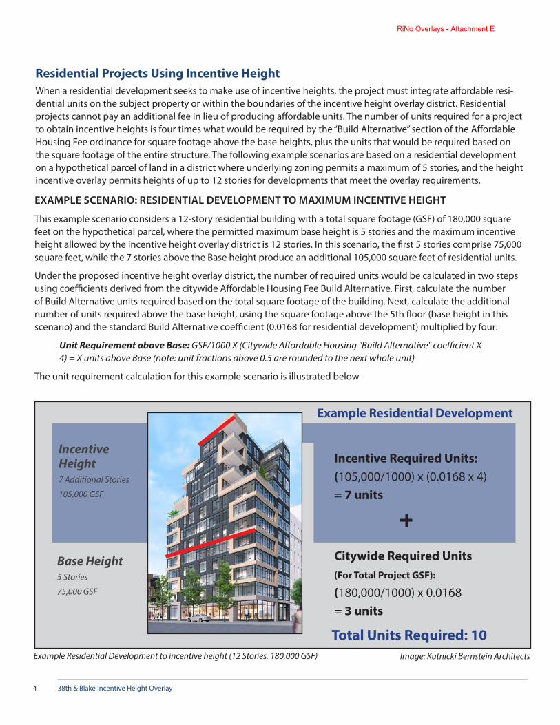
38th & Blake Incentive Height Overlay4
Base Height 5 Stories
75,000 GSF
Citywide Required Units(For Total Project GSF):
(180,000/1000) x 0.0168= 3 units
Total Units Required: 10
Incentive Required Units:(105,000/1000) x (0.0168 x 4) = 7 units
Incentive Height 7 Additional Stories
105,000 GSF
Image: Kutnicki Bernstein ArchitectsExample Residential Development to incentive height (12 Stories, 180,000 GSF)
Example Residential Development
Residential Projects Using Incentive HeightWhen a residential development seeks to make use of incentive heights, the project must integrate affordable resi-dential units on the subject property or within the boundaries of the incentive height overlay district. Residential projects cannot pay an additional fee in lieu of producing affordable units. The number of units required for a project to obtain incentive heights is four times what would be required by the “Build Alternative” section of the Affordable Housing Fee ordinance for square footage above the base heights, plus the units that would be required based on the square footage of the entire structure. The following example scenarios are based on a residential development on a hypothetical parcel of land in a district where underlying zoning permits a maximum of 5 stories, and the height incentive overlay permits heights of up to 12 stories for developments that meet the overlay requirements.
EXAMPLE SCENARIO: RESIDENTIAL DEVELOPMENT TO MAXIMUM INCENTIVE HEIGHT
This example scenario considers a 12-story residential building with a total square footage (GSF) of 180,000 square feet on the hypothetical parcel, where the permitted maximum base height is 5 stories and the maximum incentive height allowed by the incentive height overlay district is 12 stories. In this scenario, the first 5 stories comprise 75,000 square feet, while the 7 stories above the Base height produce an additional 105,000 square feet of residential units.
Under the proposed incentive height overlay district, the number of required units would be calculated in two steps using coefficients derived from the citywide Affordable Housing Fee Build Alternative. First, calculate the number of Build Alternative units required based on the total square footage of the building. Next, calculate the additional number of units required above the base height, using the square footage above the 5th floor (base height in this scenario) and the standard Build Alternative coefficient (0.0168 for residential development) multiplied by four:
Unit Requirement above Base: GSF/1000 X (Citywide Affordable Housing "Build Alternative" coefficient X 4) = X units above Base (note: unit fractions above 0.5 are rounded to the next whole unit)
The unit requirement calculation for this example scenario is illustrated below.
RiNo Overlays - Attachment E

38th & Blake Incentive Height Overlay 5
New building at 17th St. & Wewatta St. Image Source: denver-cityscape.com
Commercial Projects Using Incentive HeightCommercial projects, such as office buildings, have three options for obtain-ing the incentive height bonus:
1. Payment of the citywide Affordable Housing Fee plus fees for develop-ment above the base height;
2. Construction of affordable residential units (on- or off-site, but within the incentive height overlay district area boundary);
3. Payment of the citywide Affordable Housing Fee and provision of subsi-dized space for community-serving or nonprofit uses.
Examples of community-serving uses that could be considered for option 3 include arts-related activities like maker spaces and studios; retail of goods needed in the community (e.g. pharmacies, grocery stores); needed services, such as child care and medical clinics; and nonprofit organizations. Appli-cants will be required to enter into an agreement with the Denver Office of Economic Development, which will consider the proposed use in light of area needs. The value of the space provided must be equal to the waived incentive fees.
EXAMPLE SCENARIO: COMMERCIAL DEVELOPMENT TO MAXIMUM INCENTIVE HEIGHT
This example scenario considers a 12-story commercial office building with a total square footage (GSF) of 180,000 square feet on the hypothetical parcel, where the permitted base height is 5 stories and the incentive height is 12 stories. As with the residential development scenario, in this example the first 5 stories comprise 75,000 square feet, while the 7 stories above the Base height produce an additional 105,000 square feet of commercial space.
While incentive height requirements for residential uses are based a multiple of the citywide Affordable Housing Fee Build Alternative, the incentive sys-tem for non-residential uses would provide three options:
1. Fee Option
2. Unit Option
3. Community-serving Use Option
The fee, unit and community-serving use requirement calculations for the commercial example scenario are illustrated on the following page.
RiNo Overlays - Attachment E
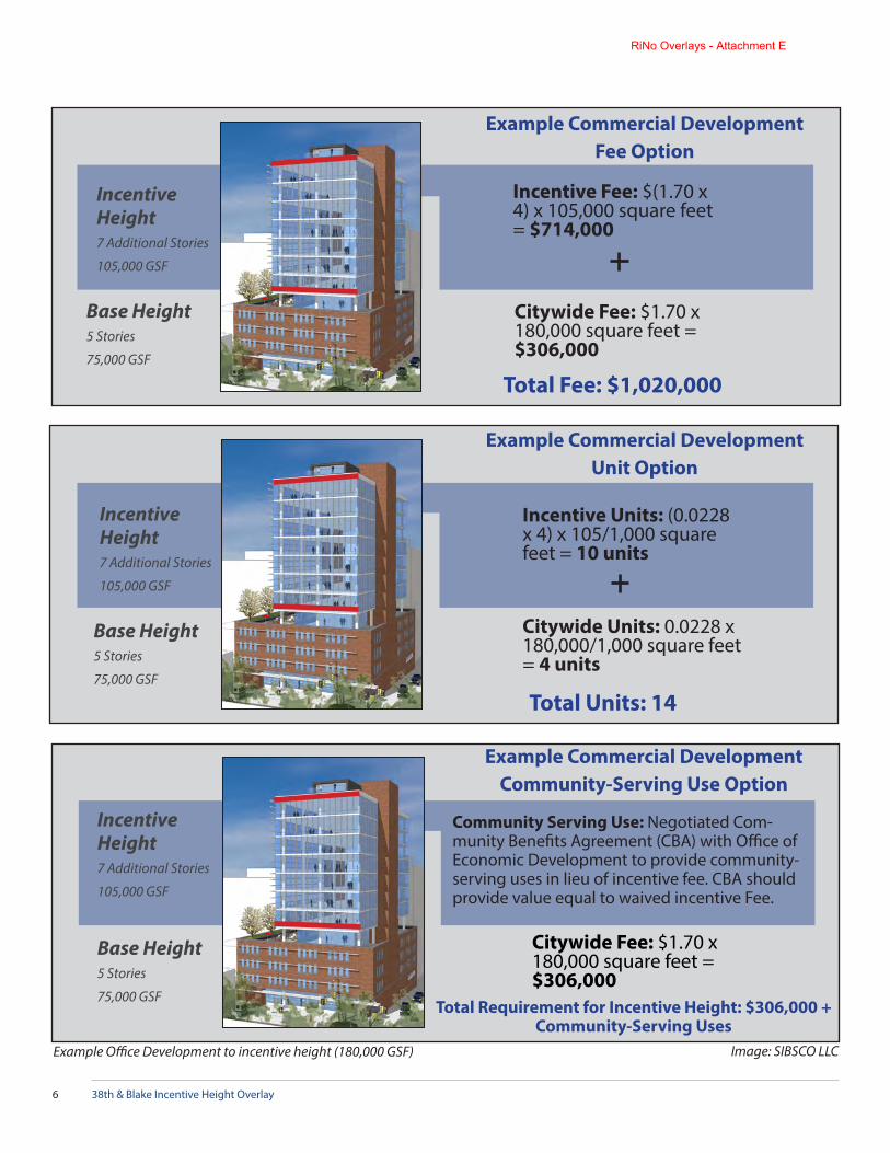
38th & Blake Incentive Height Overlay6
Base Height 5 Stories
75,000 GSF
Citywide Fee: $1.70 x 180,000 square feet = $306,000
Incentive Height 7 Additional Stories
105,000 GSF
Incentive Fee: $(1.70 x 4) x 105,000 square feet = $714,000
Total Fee: $1,020,000
Example Commercial DevelopmentFee Option
Example Commercial DevelopmentUnit Option
Incentive Units: (0.0228 x 4) x 105/1,000 square feet = 10 units
Citywide Units: 0.0228 x 180,000/1,000 square feet = 4 units
Base Height 5 Stories
75,000 GSF
Incentive Height 7 Additional Stories
105,000 GSF
Citywide Fee: $1.70 x 180,000 square feet = $306,000
Base Height 5 Stories
75,000 GSF
Incentive Height 7 Additional Stories
105,000 GSF
Community Serving Use: Negotiated Com-munity Benefits Agreement (CBA) with Office of Economic Development to provide community-serving uses in lieu of incentive fee. CBA should provide value equal to waived incentive Fee.
Example Commercial DevelopmentCommunity-Serving Use Option
Example Office Development to incentive height (180,000 GSF) Image: SIBSCO LLC
Total Units: 14
Total Requirement for Incentive Height: $306,000 + Community-Serving Uses
RiNo Overlays - Attachment E

38th & Blake Incentive Height Overlay 7
Definitions Used in this DocumentAffordable Housing Fee: A fee on commercial and residential development in the City and County of Denver as-sessed to help fund the creation and/or preservation of affordable housing. (Chapter 27, Article 5 of the Denver Revised Municipal Code)
Build Alternative: A number of affordable residential units that may be provided in lieu of paying the Affordable Housing Fee, as specified by Chapter 27, Article 5, Division 2, Sec. 27-155 of the Denver Revised Municipal Code.
Incentive Height Overlay District: An area designated on the Official Zoning Map where building heights are per-mitted to exceed maximums established by underlying zoning, in return for affordable housing or other community benefits.
Base Height: In an incentive height overlay district, the base height is established by underlying zoning and is the maximum height to which buildings can be constructed without providing extra affordable units or paying additional fees beyond the standard Affordable Housing Fee.
Incentive Height: In an incentive height overlay district, the incentive height is an additional building height maxi-mum permitted beyond the base height in return for additional fees, a specified number of affordable units, or other community benefits.
Gross Square Footage (GSF): the sum of floor area in a building. GSF is used to calculate fee and/or unit requirements for the Affordable Housing Fee and for additional requirements of the incentive height overlay district.
For More Information, Visit the Project Website:www.denvergov.org/38blake
RiNo Overlays - Attachment E

38th & Blake Station AreaIncentive Height Overlay Feasibility Study
What is this study?
To implement the 2016 38th and Blake Station Area Height Amendments, the Denver Community Planning and Devel-opment Department, and Office of Economic Development have been collaborating with City Council President Albus Brooks to develop an Incentive Height Overlay zone district. This proposed system aims to incentivize the production of affordable housing near RTD's University of Colorado A-Line station in return for building heights exceeding what is permitted by underlying zoning. The amount of affordable housing required to obtain taller building heights would be calculated based on a set of formulas established by the Overlay.
In order to test the feasibility of this proposed system, the City contracted with California development advisory firm David Paul Rosen and Associates, which has previously analyzed other City initiatives, such as the Affordable Housing Linkage Fee. The study is a model analysis based on localized assumptions for land value, construction costs, expected income and other factors for a variety of residential and non-residential prototypes. These assumptions originated from third-party sources based on local trends, which were then distributed to developers working in the River North Arts District area for review and refinement to reflect current conditions in Denver.
Outcomes, as indicated by Residual Land Value and Return on Equity, are modeled for projects built to one of two pos-sible scenarios that would be enabled by the Overlay:
Development to permitted base heights (3, 5 and 8 stories, reflecting existing zoning) with the typical Affordable Housing Linkage Fee that would be required of any development
Development to maximum incentive heights (5, 12 and 16 stories, as permitted by the Overlay) accounting for ad-ditional costs generated by the additional affordable housing requirements.
What did the study find?
In most of the tested scenarios, use of maximum incentive height resulted in higher financial returns (as measured by changes in Residual Land Value) than development to the maximum base height without incentives, despite costs associated with provision of additional affordable housing. More than 80% of land area within the proposed Overlay boundaries will have a base height of 8 stories and an option to build to a maximum incentive height of either 12 or 16 stories. The study indicated a higher financial return in each of these specific scenarios (8 to 12 stories and 8 to 16 stories) when built to the maximum incentive height compared to the maximum base height without incentives.
What happens next?
The project team will continue refining the proposed Incentive Height Overlay zone district in response to stakeholder feedback. It is expected that the formal adoption process for this system would begin in early December, with a final City Council hearing in February. If adopted by the City Council, this system would be in place and ready for use in development by early Spring.
Where can I learn more?
www.denvergov.org/38blake
RiNo Overlays - Attachment F

October 11, 2017 To: Abe Barge Andrew Webb Laura Brudzynski From: Nora Lake-Brown David Rosen Subject: Financial Analysis of Proposed 38th & Blake Incentive Height
Overlay This memorandum presents a financial analysis of the proposed 38th and Blake Incentive Height Overlay (Overlay). DRA analyzed the estimated financial feasibility of prototypical residential and office projects with and without utilization of the provisions of the Overlay. The study found that 7 of the 10 development scenarios considered would generate higher returns by building to incentive heights while providing affordable housing, rather than building to the base heights permitted by underlying zoning. In this memo, we summarize the approach and findings of the analysis, followed by a description of the development prototypes and financial return measures used. The attached appendix contains detailed tables with all of the financial analysis assumptions and calculations. Background and Approach The proposed 38th and Blake Incentive Height Overlay (Overlay) would apply to three base heights and three incentive heights allowing the following options: Base Height Incentive Height
3-story to 5-story 5-story to 12-story 5-story to 16-story 8-story to 12-story 8-story to 16-story
RiNo Overlays - Attachment F

Abe Barge, Andrew Webb, Laura Brudzynski October 11, 2017 Page 2 of 5 DRA used a series of five residential and five office prototypes to estimate the economic effect of using the provisions of the Overlay. In particular, we compared the financial performance of the base-height prototype with that of the incentive height prototype, after accounting for the requirements of the Overlay. The base height prototypes assume payment of the citywide nexus fee, while the incentive height prototypes assume compliance with the following requirements of the ordinance:
Assumed Requirements 38th and Blake Height Incentive
Requirement Commercial Residential
Citywide Requirement (on Total Floor Area)
$1.70/SF 0.0168 Units/1000 SF
Incentive Requirement1 (on Incentive Floor Area)
$6.80/SF 0.0672 Units/1000 SF
1Equals four times citywide requirement.
We used a site size of 1-acre for each of the residential prototypes, so that we could use the higher-density prototypes to model the incentive versions of the lower-density base height prototypes. For the office prototypes, we assumed a site size of 0.75 acres. We first analyzed the financial feasibility of the three base-height prototypes (3-story, 5-story and 8-story) assuming payment of the Citywide nexus fee. We then compared the feasibility of the incentive prototypes for these sites (5-story, 12-story, 16-story) after accounting for the loss in net operating income in the residential prototypes (resulting from lower affordable rents on some units) and additional nexus fees on the office prototypes costs required to comply with the Overlay requirements.
RiNo Overlays - Attachment F

Abe Barge, Andrew Webb, Laura Brudzynski October 11, 2017 Page 3 of 5 The financial effect on prototypical residential and office developments of utilizing the provisions of the Overlay were analyzed using two financial measures:
1. Residual land value (RLV): The value to the land generated by income-producing uses on site, after accounting for development costs, including developer overhead and profit.
2. Annual return on equity (ROE): Estimated net annual cash flow after debt service as a percentage of the total equity investment.
Summary of Findings Table 1 summarizes key findings of the financial analysis. The residual land value (RLV) and return on equity (ROE) are shown for each of the incentive options. The options are distinguished by the base and incentive building heights listed in each column at the top of the table. Residual land value (RLV) per square foot of site area is shown for the base height and the incentive height prototypes, along with the percentage increase (or decrease) in residual land value resulting from going from the base height to the incentive height under each option. Residual land values can be compared with estimated market land costs of $120 (low scenario) to $200 (high scenario) shown in the assumption section of the table as an indication of feasibility. If RLVs are nearly equal to or above estimated market land values the prototype is considered feasible. If the RLV increases from the base height to the incentive height then the incentive is having a positive net financial impact on the project. ROEs can be compared to an estimated threshold return of 8%.
RiNo Overlays - Attachment F

Abe Barge, Andrew Webb, Laura Brudzynski October 11, 2017 Page 4 of 5 Development Prototypes DRA used five residential and five office prototypes (3-story, 5-story, 8-story, 12-story and 16-story) to analyze the impact of the Overlay on project financial performance. DRA scaled residential and office development prototypes from its 2016 nexus fee feasibility analysis to produce the prototypes listed above, with input from City staff on site size, density, parking, residential unit mix, and other development characteristics. Ground floor retail is included in the 8-story to 16-story prototypes. Measures of Financial Return DRA evaluated the economic feasibility of the prototype developments using Residual Land Value (RLV) and Return on Equity (ROE) approaches. Residual Land Value analysis methodology calculates the value of a development based on its income potential and subtracts the costs of development (excluding land but including an assumed return on the land and improvement costs), to yield the underlying value of the land. An alternative that generates a value to the land that is negative, or well below market land sales prices, is not financially feasible. The ROE approach calculates the annual net cash flow from development based on its stabilized net operating income potential and subtracts the annual debt service for the portion of total development costs (including land) that is financed with debt. The annual net cash flow after debt represents the available return on equity. Annual net cash flow is then divided by the total amount of equity investment in the project to determine the ROE. Both approaches calculate the value of rental prototypes (residential and non-residential) at a point in time based on the estimated stabilized net operating income of the prototype. The RLV and ROE measures are calculated for each prototype assuming development at the base height, and then compared to the RLV and the ROE of the development at the incentive height. Development costs for the base height prototypes include the citywide nexus fees for residential and office uses.
RiNo Overlays - Attachment F

Abe Barge, Andrew Webb, Laura Brudzynski October 11, 2017 Page 5 of 5 Development of the residential prototypes at the incentive height assumes the inclusion of the required affordable units, and the rental income at affordable rents for these units. Development costs for the office prototypes at the incentive height include the base citywide fee plus the additional incentive fee. DRA compares the RLV and ROE of the base height and incentive height prototypes to evaluate the effect of the Overlay provisions on the financial feasibility of, and financial returns from, the developments. Cost and Revenue Assumptions The cost and revenue assumptions used in the analysis are detailed in the attached tables. DRA started with estimates of current 2017 rents, operating costs and development costs based on interviews with selected developers. Since projects coming on line at today’s rents started construction several years ago, DRA reduced the building and parking hard cost assumptions back to the estimated start of construction using the estimated development time period for each prototype. This adjustment was based on the Mortenson Construction Cost Index for Denver, which indicates that construction costs increased 18% from Q2 2013 to Q2 2017 and 13% from Q2 2014 to Q2 2017, or roughly 4.3% to 4.5% annually.
RiNo Overlays - Attachment F

Table Number Table Page
Table 1 Summary of Economic Feasibility Analysis Results 1Table 2 Development Prototypes 2Table 3 Development Cost Assumptions and Budgets 3Table 4 Net Operating Income from Market-Rate Apartments 5Table 5 Net Operating Income from Office Uses 6Table 6 Affordable and Market Rate Units: Rental Housing Prototypes with Height
Incentives7
Table 7 Affordable Rents: Mid- and High-Rise Rental Housing Prototypes with Incentive
8
Table 8 Affordable Rental Income: Rental Housing Prototypes with Incentive 9Table 9 Net Operating Income: Prototypes with Height Incentives 10Table 10 Land Residual Analysis: Base Height Prototypes 11Table 11 Land Residual Analysis: Prototypes with Incentives 12Table 12 Return on Equity Analysis: Base Height PrototypesTable 13 Return on Equity Analysis: Prototypes with Height Incentives
City of Denver
11-Oct-17Feasibility Analysis Results
38th and Blake Overlay
RiNo Overlays - Attachment F

Table 1Summary of Economic Feasibility Analysis ResultsDenver 38th and Blake Overlay Analysis
Base Height 3-Story 5-Story 5-Story 8-Story 8-Story 3-Story 5-Story 5-Story 8-Story 8-Story
Incentive Height 5-Story 12-Story 16-Story 12-Story 16-Story 5-Story 12-Story 16-Story 12-Story 16-Story
Site Area (SF) 43,560 43,560 43,560 43,560 43,560 32,670 32,670 32,670 32,670 32,670
Base Height Project CharacteristicsResidential Units 65 100 100 200 200 - - - - - Residential Net SF 46,050 70,750 70,750 141,500 141,500 - - - - - Office Net SF 46,050 43,560 43,560 43,560 43,560 24,000 56,000 56,000 92,000 92,000 Retail Net SF - - - 5,000 5,000 - - - 5,000 5,000 Total Net SF 46,050 70,750 70,750 146,500 146,500 24,000 56,000 56,000 97,000 97,000 Total Gross SF (Excluding Parking) 51,167 78,611 78,611 195,333 195,333 30,000 70,000 70,000 121,250 121,250 Parking Spaces 49 Spaces 75 Spaces 75 Spaces 150 Spaces 150 Spaces 60 Spaces 140 Spaces 140 Spaces 230 Spaces 230 SpacesApproximate Building Stories 3 Stories 5 Stories 5 Stories 8 Stories 8 Stories 3 Stories 5 Stories 5 Stories 5 Stories 5 Stories
Incentive Height Project CharacteristicsResidential Units 100 280 360 280 360 Residential Net SF 70,750 197,850 254,700 197,850 254,700 - - - - - Office Net SF - - - - - 56,000 116,000 164,000 116,000 164,000 Retail Net SF - 5,000 5,000 5,000 5,000 - 5,000 5,000 5,000 5,000 Total Net SF 70,750 202,850 259,700 24,000 56,000 56,000 121,000 169,000 121,000 169,000 Total Gross SF (Excluding Parking) 78,611 270,467 346,267 270,467 346,267 70,000 151,250 211,250 151,250 211,250 Parking Spaces 75 Spaces 210 Spaces 270 Spaces 210 Spaces 270 Spaces 140 Spaces 290 Spaces 410 Spaces 290 Spaces 410 SpacesApproximate Building Stories 5 Stories 12 Stories 16 Stories 12 Stories 16 Stories 5 Stories 12 Stories 16 Stories 12 Stories 16 Stories
ASSUMPTIONSAssumed Land PriceLow Scenario Land Price Per SF Site Area $120 $120 $120 $120 $120 $120 $120 $120 $120 $120 Land Price Per Unit $52,272 $18,669 $14,520 $18,669 $14,520 N/A N/A N/A N/A N/AHigh Scenario Land Price Per SF Site Area $200 $200 $200 $200 $200 $200 $200 $200 $200 $200 Land Price Per Unit $87,120 $31,114 $24,200 $31,114 $24,200 N/A N/A N/A N/A N/AAssumed Cap Rate (1) 4.60% 4.60% 4.60% 4.60% 4.60% 5.00% 5.00% 5.00% 5.00% 5.00%Estimated Minimum Threshold ROE 8.00% 8.00% 8.00% 8.00% 8.00% 8.00% 8.00% 8.00% 8.00% 8.00%Minimum Developer Profit for RLV 15% 15% 15% 15% 15% 15% 15% 15% 15% 15%Assumed Investment Period (Months) 30 Months 48 Months 48 Months 48 Months 48 Months 18 Months 21 Months 21 Months 21 Months 21 Months
RESIDUAL LAND VALUE Per Site SF
Prototypes at Base Height $248 $295 $295 $131 $131 $29 -$24 -$24 -$66 -$66Prototypes with Incentives $289 $250 $386 $276 $427 -$32 -$15 -$26 -$4 -$15Percent Increase (Decrease) in RLV Per SF 16% -15% 31% 111% 226% -212% 38% -9% 94% 77%
RETURN ON EQUITYPrototypes at Base Height Low Scenario 10.53% 9.33% 9.33% 2.75% 2.75% 0.84% 1.85% 1.85% 2.60% 2.60% High Scenario 4.91% 5.70% 5.70% 1.72% 1.72% -1.17% 0.70% 0.70% 1.87% 1.87%Prototypes with Incentives Low Scenario 9.13% 4.10% 4.95% 4.10% 4.95% 1.99% 3.75% 4.05% 3.73% 4.04% High Scenario 5.52% 3.30% 4.28% 3.30% 4.28% 0.84% 3.11% 3.57% 3.09% 3.56%Increase (Decrease) in ROE Low Scenario -1.39% -5.23% -4.38% 1.35% 2.20% 1.15% 1.90% 2.20% 1.13% 1.44% High Scenario 0.61% -2.40% -1.43% 1.58% 2.55% 2.00% 2.41% 2.87% 1.22% 1.69%
BASE HEIGHT RLVs and ROEs (2) 3-Story 5-Story 8-Story 12-Story 16-Story 3-Story 5-Story 8-Story 12-Story 16-Story Base Height RLVs by Prototype: $247.69 $294.61 $130.84 $328.18 $505.22 $28.55 ($23.63) ($66.03) $2.16 $3.55 Base Height ROEs by Prototype: Low Land Cost Scenario 10.53% 9.33% 2.75% 4.58% 5.53% 0.84% 1.85% 2.60% 3.64% 3.94% High Land Cost Scenario 4.91% 5.70% 1.72% 3.77% 4.84% -1.17% 0.70% 1.87% 3.00% 3.46%
(1) Based on CBRE 1st Half 2017 Cap Rate Survey data for the City of Denver. Represents the mid point of the estimated current cap rate range for urban residential and office projects.(2) For base height prototypes without incentives.Source: DRA.
Rental Residential Office
RiNo Overlays - Attachment F

Table 2Development PrototypesDenver 38th and Blake Overlay Analysis
3-Story 5-Story 8-Story 12-Story 16-Story 3-Story 5-Story 8-Story 12-Story 16-Story 4-Story Hotel
Primary Land Use Residential Residential Residential Residential Residential Office Office Office Office OfficeOther Land Use 1st Floor Retail 1st Floor Retail 1st Floor Retail 1st Floor Retail 1st Floor Retail 1st Floor Retail
Total Residential Units 65 100 200 280 360Total DU's/Acre 65 100 200 280 360
Total Site Area (Acre) 1.00 Acres 1.00 Acres 1.00 Acres 1.00 Acres 1.00 Acres 0.75 Acres 0.75 Acres 0.75 Acres 0.75 Acres 0.75 AcresTotal Site Area (SF) 43,560 43,560 43,560 43,560 43,560 32,670 32,670 32,670 32,670 32,670
Construction Type Type V Type V over Type I
LG Steel/Podium Type 1 Type 1 Type V Type II Light Gauge Type 1 Type 1
Parking Type Garage Structured Subterranean/ Structured
Subterranean/ Structured
Subterranean/ Structured
Surface Structured Subterranean/ Structured
Subterranean/ Structured
Subterranean/ Structured
Approximate Building Stories 3 Stories 5 Stories 8 Stories 12 Stories 16 Stories 3 Stories 5 Stories 8 Stories 12 Stories 16 Stories
Total Gross Building SF (Excluding Parking) 51,167 78,611 195,333 270,467 346,267 SF 30,000 SF 70,000 SF 121,250 SF 151,250 SF 211,250 SFFAR 1.2 1.8 4.5 6.2 7.9 0.9 2.1 3.7 4.6 6.5 Total Gross Bldg. SF, Incl. Struct./Underg. Pkg (1) 51,167 104,861 247,833 343,967 440,917 30,000 119,000 201,750 252,750 354,750
Building Efficiency Ratio (%) 90% 90% 75% 75% 75% 80% 80% 80% 80% 80%Site Coverage (Bldg. Footprint) (%) 33% 70% 85% 85% 85% 80% 80% 80% 80% 80%Average Floor Plate (GSF) 17,056 30,500 37,000 37,000 37,000 10,000 26,100 26,100 26,100 26,100Bldg. Footprint Plus Surface Parking (GSF) 36,656 30,500 37,000 37,000 37,000 31,000 26,100 26,100 26,100 26,100Bldg. Footprint Plus Surface Parking (% of Site) 84% 95%
Levels of Underground Parking 0.0 0.0 1.0 2.0 2.0 0.0 0.0 2.0 2.0 2.0Levels of Structured Parking Above Grade 0.0 0.9 0.4 0.0 0.6 2.1 1.9 3.1 3.9 5.5Stories of Office (& Retail) Space 0.0 0.0 0.2 0.2 0.2 3.0 2.7 4.6 5.8 8.1Stories of Residential Space 3.0 2.6 5.1 7.1 8.0 0.0 0.0 0.0 0.0 0.0Total Stories Above Ground 3.0 3.4 6.7 9.3 10.7 5.1 4.6 9.7 11.7 15.6
Net Rentable SF Office 0 SF 0 SF 0 SF 0 SF 0 SF 24,000 SF 56,000 SF 92,000 SF 116,000 SF 164,000 SFNet Rentable SF Hotel 0 SF 0 SF 0 SF 0 SF 0 SF 0 SF 0 SF 0 SF 0 SF 0 SFNet Rentable SF Retail 0 SF 0 SF 5,000 SF 5,000 SF 5,000 SF 0 SF 0 SF 5,000 SF 5,000 SF 5,000 SFNet Rentable SF Warehouse 0 SF 0 SF 0 SF 0 SF 0 SF 0 SF 0 SF 0 SF 0 SF 0 SFNet Rentable SF Manufacturing 0 SF 0 SF 0 SF 0 SF 0 SF 0 SF 0 SF 0 SF 0 SF 0 SFNet Rentable SF Residential 46,050 SF 70,750 SF 141,500 SF 197,850 SF 254,700 SF 0 SF 0 SF 0 SF 0 SF 0 SFNet Rentable SF Total 46,050 SF 70,750 SF 146,500 SF 202,850 SF 259,700 SF 24,000 SF 56,000 SF 97,000 SF 121,000 SF 169,000 SFTotal Net Bldg. SF 46,050 SF 70,750 SF 146,500 SF 202,850 SF 259,700 SF 24,000 SF 56,000 SF 97,000 SF 121,000 SF 169,000 SF
Gross SF Office 0 SF 0 SF 0 SF 0 SF 0 SF 30,000 SF 70,000 SF 115,000 SF 145,000 SF 205,000 SFGross SF Retail 0 SF 0 SF 6,667 SF 6,667 SF 6,667 SF 0 SF 0 SF 6,250 SF 6,250 SF 6,250 SFGross SF Residential 51,167 SF 78,611 SF 188,667 SF 263,800 SF 339,600 SF 0 SF 0 SF 0 SF 0 SF 0 SFTotal Gross Bldg. SF Excluding Parking 51,167 SF 78,611 SF 195,333 SF 270,467 SF 346,267 SF 30,000 SF 70,000 SF 121,250 SF 151,250 SF 211,250 SFTotal Gross Bldg. SF Including Parking 70,767 SF 104,861 SF 247,833 SF 343,967 SF 440,917 SF 51,000 SF 119,000 SF 201,750 SF 252,750 SF 354,750 SF
Unit Bedroom Count Distribution Studio/Loft/Shotgun 1 BR 20% 20% 20% 20% 20% . . . One Bedroom 65% 65% 65% 65% 65% Two Bedroom 15% 15% 15% 15% 15% Three Bedroom 0% 0% 0% 0% 0%Total 100% 100% 100% 100% 100%
Units by BR Count Studio/Loft/Shotgun 1 BR 13 20 40 56 72 One Bedroom 42 65 130 183 234 Two Bedroom 10 15 30 41 54 Three Bedroom 0 0 0 0 0Total Residential Units 65 100 200 280 360Residential Density (units per acre) 65 du/a 100 du/a 200 du/a 280 du/a 360 du/a
Unit Size (Net SF) Studio/Loft/Shotgun 1 BR 550 SF 550 SF 550 SF 550 SF 550 SF One Bedroom 700 SF 700 SF 700 SF 700 SF 700 SF Two Bedroom 950 SF 950 SF 950 SF 950 SF 950 SF Three Bedroom 0 SF 0 SF 0 SF 0 SF 0 SF Average Unit Size 708 SF 708 SF 708 SF 707 SF 708 SF
Parking Ratio - Residential (Spaces/Unit) Studio/Loft/Shotgun 1 BR 0.75 0.75 0.75 0.75 0.75 One Bedroom 0.75 0.75 0.75 0.75 0.75 Two Bedrooms 0.75 0.75 0.75 0.75 0.75 Three Bedrooms 0.75 0.75 0.75 0.75 0.75 Parking Spaces Based on Ratio--Residential 49 75 150 210 270
Parking Ratio - Office (GSF/Space) 500 500 500 500 500 Parking Spaces Based on Ratio--Office 60 140 230 290 410Parking Ratio - Retail (GSF/Space) 0 0 0 0 0 Parking Spaces Based on Ratio--Retail 0 0 0 0 0Parking Spaces - Total Based on Ratio 60 140 230 290 410
Parking Spaces Per Floor 87 106 106 106 75 75 75 75
No. of Underground Parking Spaces 0 Spaces 0 Spaces 106 Spaces 210 Spaces 211 Spaces 0 Spaces 0 Spaces 150 Spaces 150 Spaces 150 SpacesNo. of Structured Parking Spaces 0 Spaces 75 Spaces 44 Spaces 0 Spaces 59 Spaces 0 Spaces 140 Spaces 80 Spaces 140 Spaces 260 SpacesNo. of Surface/Garage Parking Spaces 49 Spaces 0 Spaces 0 Spaces 0 Spaces 0 Spaces 60 Spaces 0 Spaces 0 Spaces 0 Spaces 0 SpacesTotal Parking Spaces Provided 49 Spaces 75 Spaces 150 Spaces 210 Spaces 270 Spaces 60 Spaces 140 Spaces 230 Spaces 290 Spaces 410 SpacesParking Spaces Provided /Unit or /1000 SF 0.75 Spaces/Unit 0.75 Spaces/Unit 0.75 Spaces/Unit 0.75 Spaces/Unit 0.75 Spaces/Unit 500 GSF/Space 500 GSF/Space 527 GSF/Space 522 GSF/Space 515 GSF/SpaceGross SF/Parking Space (Incl. Circulation) 400 SF 350 SF 350 SF 350 SF 350 SF 350 SF 350 SF 350 SF 350 SF 350 SFTotal Parking SF 19,600 SF 26,250 SF 52,500 SF 73,500 SF 94,500 SF 21,000 SF 49,000 SF 80,500 SF 101,500 SF 143,500 SFParking SF Underground 0 SF 0 SF 37,000 SF 73,500 SF 74,000 SF 0 SF 0 SF 52,500 SF 52,500 SF 52,500 SFParking SF Structured 0 SF 26,250 SF 15,500 SF 0 SF 20,650 SF 0 SF 49,000 SF 28,000 SF 49,000 SF 91,000 SFParking SF Surface 19,600 SF 0 SF 0 SF 0 SF 0 SF 21,000 SF 0 SF 0 SF 0 SF 0 SFTotal Parking GSF 19,600 SF 26,250 SF 52,500 SF 73,500 SF 94,650 SF 21,000 SF 49,000 SF 80,500 SF 101,500 SF 143,500 SF
Source: Interviews with Denver area developers; City of Denver; DRA
Rental Residential Office
RiNo Overlays - Attachment F

Table 3Development Cost Assumptions and BudgetsDevelopment PrototypesDenver 38th and Blake Overlay Analysis
3-Story 5-Story 8-Story 12-Story 16-Story 3-Story 5-Story 8-Story 12-Story 16-Story
PROTOTYPE ASSUMPTIONS
Total Residential Units 65 100 200 280 360Average Unit Size (Net SF) 708 708 708 707 708Residential Net SF 46,050 70,750 141,500 197,850 254,700 0 0 0 0 0Hotel Rooms 0 0 0 0 0 0 0 0 0 0Average Hotel Room Size (Net SF) 0 0 0 0 0 0 0 0 0 0Total Net SF (Rentable/Saleable SF) 46,050 70,750 146,500 202,850 259,700 24,000 56,000 97,000 121,000 169,000Total Gross SF Building Area (Excluding Parking) 51,167 78,611 195,333 270,467 346,267 30,000 70,000 121,250 151,250 211,250Total Gross SF Building Area (Including Str/Und Parking) 51,167 104,861 247,833 343,967 440,917 30,000 119,000 201,750 252,750 354,750Underground Parking GSF, First Level 0 0 37,000 37,000 37,000 0 0 26,100 26,100 26,100Underground Parking GSF, Second Level 0 0 0 36,500 37,000 0 0 26,400 26,400 26,400Structured Parking GSF 0 26,250 15,500 0 20,650 0 49,000 28,000 49,000 91,000Surface/Garage Parking GSF 19,600 0 0 0 0 21,000 0 0 0 0Total Parking Spaces 49 75 150 210 270 60 140 230 290 410Total Parking GSF 19,600 26,250 52,500 73,500 94,500 21,000 49,000 80,500 101,500 143,500Site Area (SF) 43,560 43,560 43,560 43,560 43,560 32,670 32,670 32,670 32,670 32,670Approximate Building Stories 3 Stories 5 Stories 8 Stories 12 Stories 16 Stories 3 Stories 5 Stories 8 Stories 12 Stories 16 Stories
DEVELOPMENT COST ASSUMPTIONS
% Reduction in Hard Costs to Start of Construction (1) 9.0% 11.0% 14.0% 17.0% 17.0% 6.0% 6.0% 8.0% 8.0% 8.0%Construction and Sales/Stabilization Period (Months) 24 Months 30 Months 40 Months 48 Months 48 Months 18 Months 18 Months 21 Months 21 Months 21 Months
Land Price Low Scenario Per Hsg. Unit $80,418 $52,272 $26,136 $18,669 $14,520 Low Scenario Per Site SF $120 $120 $120 $120 $120 $120 $120 $120 $120 $120 High Scenario Per Hsg. Unit $134,031 $87,120 $43,560 $31,114 $24,200 High Scenario Per Site SF $200 $200 $200 $200 $200 $200 $200 $200 $200 $200
Current Bldg. Hard Cost/GSF Low Scenario $110 $150 $225 $240 $240 $130 $150 $160 $170 $175 High Scenario $110 $150 $225 $240 $240 $130 $150 $160 $170 $175Est. Bldg. Hard Cost/GSF aT Construction Close Low Scenario (Used in Pro Forma) $101 $135 $197 $205 $205 $123 $142 $148 $157 $162 High Scenario (Used in Pro Forma) $101 $135 $197 $205 $205 $123 $142 $148 $157 $162Current Parking Cost/GSF Underground, First Level $110 $110 $110 $110 $110 $110 $110 $110 $110 $110 Underground, Second Level $120 $120 $120 $120 $120 $120 $120 $120 $120 $120 Above Grade Structure $65 $65 $65 $65 $65 $65 $65 $65 $65 $65 Surface/Garage $40 $40 $40 $40 $40 $40 $40 $40 $40 $40Est. Parking Cost/GSF at Construction Close Underground, First Level $101 $99 $96 $94 $94 $104 $104 $102 $102 $102 Underground, Second Level $110 $108 $105 $103 $103 $113 $113 $111 $111 $111 Above Grade Structure $60 $59 $57 $56 $56 $61 $61 $60 $60 $60 Surface/Garage $37 $36 $35 $34 $34 $38 $38 $37 $37 $37Tenant Improvements (Per Net SF) Low Scenario $60 $60 $60 $60 $60 High Scenario $60 $60 $60 $60 $60
Soft Costs (2) % of Hard Costs 20.0% 20.0% 20.0% 20.0% 20.0% 20.0% 20.0% 20.0% 20.0% 20.0%
Minimum Return AssumptionsCap Rate 4.60% 4.60% 4.60% 4.60% 4.60% 5.00% 5.00% 5.00% 5.00% 5.00%Minimum Developer Profit on Land + Improvements (3) 15.0% 15.0% 15.0% 15.0% 15.0% 15.0% 15.0% 15.0% 15.0% 15.0%Equity as a % of TDC 30.0% 30.0% 30.0% 30.0% 30.0% 40.0% 40.0% 40.0% 40.0% 40.0%
Rental Residential Office
RiNo Overlays - Attachment F
Table 3Development Cost Assumptions and BudgetsDevelopment PrototypesDenver 38th and Blake Overlay Analysis
3-Story 5-Story 8-Story 12-Story 16-Story 3-Story 5-Story 8-Story 12-Story 16-Story Rental Residential Office
DEVELOPMENT BUDGET
Low ScenarioLand Acquisition $5,227,000 $5,227,000 $5,227,000 $5,227,000 $5,227,000 $3,920,000 $3,920,000 $3,920,000 $3,920,000 $3,920,000Hard Construction Costs $5,168,000 $10,613,000 $38,481,000 $55,446,000 $70,985,000 $3,690,000 $9,940,000 $17,945,000 $23,746,000 $34,223,000Tenant Improvements $0 $0 $0 $0 $0 $1,440,000 $3,360,000 $5,820,000 $7,260,000 $10,140,000Underground Parking $0 $0 $3,552,000 $7,237,500 $7,289,000 $0 $0 $5,592,600 $5,592,600 $5,592,600Above Grade Structured Parking $0 $1,548,750 $883,500 $0 $1,156,400 $0 $2,989,000 $1,680,000 $2,940,000 $5,460,000On-Grade Surface Parking $725,200 $0 $0 $0 $0 $798,000 $0 $0 $0 $0Soft Costs (2) $1,178,640 $2,432,350 $8,583,300 $12,536,700 $15,886,080 $1,185,600 $3,257,800 $6,207,520 $7,907,720 $11,083,120
___________ ___________ ___________ ___________ ___________ ___________ ___________ ___________ ___________ ___________Total Development Costs, Including Land $12,298,840 $19,821,100 $56,726,800 $80,447,200 $100,543,480 $11,033,600 $23,466,800 $41,165,120 $51,366,320 $70,418,720
TDC Per Housing Unit $189,213 $198,211 $283,634 $287,311 $279,287 N/A N/A N/A N/A N/A TDC per NSF Rentable/Saleable Area $267 $280 $387 $397 $387 $460 $419 $424 $425 $417 TDC per Gross SF, Excluding Parking $240 $252 $290 $297 $290 $368 $335 $340 $340 $333 TDC per Gross SF, Including Parking $240 $189 $229 $234 $228 $368 $197 $204 $203 $199
Total Development Costs, Excluding Land $7,071,840 $14,594,100 $51,499,800 $75,220,200 $95,316,480 $7,113,600 $19,546,800 $37,245,120 $47,446,320 $66,498,720
High ScenarioLand Acquisition $8,712,000 $8,712,000 $8,712,000 $8,712,000 $8,712,000 $6,534,000 $6,534,000 $6,534,000 $6,534,000 $6,534,000Hard Construction Costs $5,168,000 $10,613,000 $38,481,000 $55,446,000 $70,985,000 $3,690,000 $9,940,000 $17,945,000 $23,746,000 $34,223,000Tenant Improvements $0 $0 $0 $0 $0 $1,440,000 $3,360,000 $5,820,000 $7,260,000 $10,140,000Underground Parking $0 $0 $3,552,000 $7,237,500 $7,289,000 $0 $0 $5,592,600 $5,592,600 $5,592,600Above Grade Structured Parking $0 $1,548,750 $883,500 $0 $1,156,400 $0 $2,989,000 $1,680,000 $2,940,000 $5,460,000On-Grade Surface Parking $725,200 $0 $0 $0 $0 $798,000 $0 $0 $0 $0Soft Costs (2) $1,178,640 $2,432,350 $8,583,300 $12,536,700 $15,886,080 $1,185,600 $3,257,800 $6,207,520 $7,907,720 $11,083,120
___________ ___________ ___________ ___________ ___________ ___________ ___________ ___________ ___________ ___________Total Development Costs, Including Land $15,783,840 $23,306,100 $60,211,800 $83,932,200 $104,028,480 $13,647,600 $26,080,800 $43,779,120 $53,980,320 $73,032,720
TDC Per Housing Unit $242,828 $233,061 $301,059 $299,758 $288,968 N/A N/A N/A N/A N/A TDC per NSF Rentable/Saleable Area $343 $329 $411 $414 $401 $569 $466 $451 $446 $432 TDC per Gross SF, Excluding Parking $308 $296 $308 $310 $300 $455 $373 $361 $357 $346 TDC per Gross SF, Including Parking $308 $222 $243 $244 $236 $455 $219 $217 $214 $206
Total Development Costs, Excluding Land $7,071,840 $14,594,100 $51,499,800 $75,220,200 $95,316,480 $7,113,600 $19,546,800 $37,245,120 $47,446,320 $66,498,720
(1) Estimated based on Mortenson Construction Cost Index for Denver showing 18% increase from Q2 2013 to Q2 2017 and 13% from Q2 2014 to Q2 2017. Applied to building and parking hard costs.(2) Soft costs include A&E, consultants, construction financing costs, permits and fees, legal, accounting, insurance and developer overhead.(3) Used in Land Residual Analysis.Source: DRA.
RiNo Overlays - Attachment F
Table 4Net Operating Income from Market-Rate ApartmentsRental Residential PrototypesDenver 38th and Blake Overlay Analysis
3-Story 5-Story 8-Story 12-Story 16-Story
Net Rentable SF of Apartment Space 46,050 70,750 141,500 197,850 254,700Parking Spaces 49 75 150 210 270Net Rentable SF of Retail Space 0 0 5,000 5,000 5,000Approximate Building Stories 3 Stories 5 Stories 8 Stories 12 Stories 16 Stories
Number of Apartment Units Studio/Loft/Shotgun 1 BR 13 20 40 56 72 One Bedroom 42 65 130 183 234 Two Bedroom 10 15 30 41 54 Three Bedroom 0 0 0 0 0Total 65 100 200 280 360
Unit Size (Square Feet) Studio/Loft/Shotgun 1 BR 550 550 550 550 550 One Bedroom 700 700 700 700 700 Two Bedroom 950 950 950 950 950 Three Bedroom - - - - - Average 708 708 708 707 708
Average Monthly Rent Per Square Foot Low Scenario $2.50 $2.50 $2.75 $3.00 $3.05 High Scenario $2.50 $2.50 $2.75 $3.00 $3.05
Miscellaneous Income ($/Unit/Year) $120 $120 $120 $120 $120Rental Vacancy Rate 6.0% 6.0% 6.0% 6.0% 6.0%Rental Operating Cost/Unit (2) Low Scenario $5,500 $5,500 $7,500 $7,500 $7,500 High Scenario $5,500 $5,500 $7,500 $7,500 $7,500Retail Income ($/NSF/Year) Low Scenario $32.00 $32.00 $32.00 $32.00 $32.00 High Scenario $32.00 $32.00 $32.00 $32.00 $32.00Retail Vacancy Rate (% Gross Retail Income) 10% 10% 10% 10% 10%Retail Operating Cost (% of Gross Retail Income) 40% 40% 40% 40% 40%
LOW SCENARIO
Total Monthly Gross Rental Income $115,125 $176,875 $389,125 $593,550 $776,835Annual Gross Income $1,381,500 $2,122,500 $4,669,500 $7,122,600 $9,322,020Less: Residential Vacancy ($82,890) ($127,350) ($280,170) ($427,356) ($559,321)Plus: Misc. Income $7,800 $12,000 $24,000 $33,600 $43,200Plus: Retail Income $0 $0 $160,000 $160,000 $160,000Less: Retail Vacancy $0 $0 ($16,000) ($16,000) ($16,000)Adjusted Annual Gross Income $1,306,410 $2,007,150 $4,557,330 $6,872,844 $8,949,899
Operating CostsApartment Operating Costs ($357,500) ($550,000) ($1,500,000) ($2,100,000) ($2,700,000)Retail Operating Costs $0 $0 ($16,000) ($16,000) ($16,000)
Net Operating Income $948,910 $1,457,150 $3,041,330 $4,756,844 $6,233,899
HIGH SCENARIO
Total Monthly Gross Income $115,125 $176,875 $389,125 $593,550 $776,835Annual Gross Income $1,381,500 $2,122,500 $4,669,500 $7,122,600 $9,322,020Less: Vacancy ($82,890) ($127,350) ($280,170) ($427,356) ($559,321)Plus: Misc. Income $7,800 $12,000 $24,000 $33,600 $43,200Plus: Retail Income $0 $0 $160,000 $160,000 $160,000Less: Retail Vacancy $0 $0 ($16,000) ($16,000) ($16,000)Adjusted Annual Gross Income $1,306,410 $2,007,150 $4,557,330 $6,872,844 $8,949,899
Operating CostsApartment Operating Costs ($357,500) ($550,000) ($1,500,000) ($2,100,000) ($2,700,000)Retail Operating Costs $0 $0 ($16,000) ($16,000) ($16,000)
Net Operating Income $948,910 $1,457,150 $3,041,330 $4,756,844 $6,233,899
Source: DRA
RiNo Overlays - Attachment F

Table 5Net Operating Income from Office UsesNon-Residential PrototypesDenver 38th and Blake Overlay Analysis
3-Story 5-Story 8-Story 12-Story 16-Story
Net SF Office 24,000 56,000 92,000 116,000 164,000Net SF Retail 0 0 5,000 5,000 5,000Total Net SF Non-Residential 24,000 56,000 97,000 121,000 169,000Parking Spaces 60 140 230 290 410 Approximate Building Stories 3 Stories 5 Stories 8 Stories 12 Stories 16 Stories
OPERATING ASSUMPTIONS
Officee Operating AssumptionsAnnual Rent Per NSF (NNN) Low Scenario $31.00 $31.00 $33.00 $35.00 $35.00 High Scenario $31.00 $31.00 $33.00 $35.00 $35.00Vacancy Rate 10.0% 10.0% 10.0% 10.0% 10.0%Operating Expenses (Annual Cost/NSF) $13.00 $13.00 $13.00 $13.00 $13.00 (Excluding BID/Met. District costs)
Retail Operating AssumptionsAnnual Rent Per NSF (NNN) Low Scenario $32.00 $32.00 $32.00 $32.00 $32.00 High Scenario $32.00 $32.00 $32.00 $32.00 $32.00Vacancy Rate 10.0% 10.0% 10.0% 10.0% 10.0%Operating Expenses (Annual Cost/NSF) $13 $13 $13 $13 $13
Parking Income/Operating AssumptionsParking Income ($/Space/Month) Low Scenario $150.00 $150.00 $150.00 $150.00 $150.00 High Scenario $150.00 $150.00 $150.00 $150.00 $150.00
Parking Vacancy Rate 0.0% 0.0% 0.0% 0.0% 0.0%
STABILIZED NET OPERATING INCOME
LOW SCENARIOAnnual Gross Office Rental Income $744,000 $1,736,000 $3,036,000 $4,060,000 $5,740,000Annual Gross Retail Rental Income $0 $0 $160,000 $160,000 $160,000Annual Gross Parking Income $108,000 $252,000 $414,000 $522,000 $738,000
_________ _________ _________ _________ _________Annual Gross Non-Residential Rental Income $852,000 $1,988,000 $3,610,000 $4,742,000 $6,638,000Less: Office Vacancy ($74,400) ($173,600) ($303,600) ($406,000) ($574,000)Less: Retail Vacancy $0 $0 ($16,000) ($16,000) ($16,000)Less: Parking Vacancy $0 $0 $0 $0 $0
_________ _________ _________ _________ _________Adjusted Annual Gross Income $777,600 $1,814,400 $3,290,400 $4,320,000 $6,048,000Less: Office Operating Expenses ($312,000) ($728,000) ($1,196,000) ($1,508,000) ($2,132,000)Less: Retail Operating Expenses $0 $0 ($65,000) ($65,000) ($65,000)Less: Parking Operating Expenses $0 $0 $0 $0 $0Annual Total Net Operating Income $465,600 $1,086,400 $2,029,400 $2,747,000 $3,851,000Net Operating Income Per NSF $19.40 $19.40 $20.92 $22.70 $22.79
HIGH SCENARIOAnnual Gross Office Rental Income $744,000 $1,736,000 $3,036,000 $4,060,000 $5,740,000Annual Gross Retail Rental Income $0 $0 $160,000 $160,000 $160,000Annual Gross Parking Income $108,000 $252,000 $414,000 $522,000 $738,000_________ _________ _________ _________ _________Annual Gross Non-Residential Rental Income $852,000 $1,988,000 $3,610,000 $4,742,000 $6,638,000Less: Office Vacancy ($74,400) ($173,600) ($303,600) ($406,000) ($574,000)Less: Retail Vacancy $0 $0 ($16,000) ($16,000) ($16,000)Less: Parking Vacancy $0 $0 $0 $0 $0
_________ _________ _________ _________ _________Adjusted Annual Gross Income $777,600 $1,814,400 $3,290,400 $4,320,000 $6,048,000Less: Office Operating Expenses ($312,000) ($728,000) ($1,196,000) ($1,508,000) ($2,132,000)Less: Retail Operating Expenses $0 $0 ($65,000) ($65,000) ($65,000)Less: Parking Operating Expenses $0 $0 $0 $0 $0Annual Total Net Operating Income $465,600 $1,086,400 $2,029,400 $2,747,000 $3,851,000Net Operating Income Per NSF $19.40 $19.40 $20.92 $22.70 $22.79
Source: DRA.
RiNo Overlays - Attachment F

Table 6Affordable and Market Rate Units: Rental Housing Prototypes with Height IncentivesDenver 38th and Blake Overlay Analysis
Base Height 3-Story 5-Story 5-Story 8-Story 8-StoryIncentive Height 5-Story 12-Story 16-Story 12-Story 16-Story
Total Site Area (Acre) 1.00 Acres 1.00 Acres 1.00 Acres 1.00 Acres 1.00 AcresTotal Site Area (SF) 43,560 43,560 43,560 43,560 43,560
Base Height Project Characteristics
Total Residential Units 65 100 100 200 200Gross SF Residential 51,167 SF 78,611 SF 78,611 SF 188,667 SF 188,667 SF
Incentive Height Project Characteristics
Total Residential Units 100 280 360 280 360Gross SF Residential 78,611 SF 263,800 SF 339,600 SF 263,800 SF 339,600 SFTotal Units by Bedroom Count Distribution Studio/Loft/Shotgun 1 BR 20 56 72 56 72 One Bedroom 65 183 234 183 234 Two Bedroom 15 41 54 41 54 Three Bedroom 0 0 0 0 0
Affordable Units Required Units Per GSFTotal Floor Area 0.0168 1 4 6 4 6Incentive Floor Area 0.0672 2 12 18 5 10Total Affordable Units 3 16 24 9 16
Unit Bedroom Count Distribution Studio/Loft/Shotgun 1 BR 20% 20% 20% 20% 20% One Bedroom 65% 65% 65% 65% 65% Two Bedroom 15% 15% 15% 15% 15% Three Bedroom 0% 0% 0% 0% 0%
Affordable Units by Bedroom Count Studio/Loft/Shotgun 1 BR 1 3 5 2 3 One Bedroom 2 10 15 6 10 Two Bedroom 0 2 4 1 2 Three Bedroom 0 0 0 0 0Total Affordable Units 3 15 24 9 15
Market Units Studio/Loft/Shotgun 1 BR 19 53 67 54 69 One Bedroom 63 173 219 177 224 Two Bedroom 15 39 50 40 52 Three Bedroom 0 0 0 0 0Total Market Units 97 265 336 271 345
Source: City of Denver; DRA
Rental Residential
RiNo Overlays - Attachment F

Table 7Affordable Rents: Mid- and High-Rise Rental Housing Prototypes with IncentiveDenver 38th and Blake Overlay Analysis
Assumptions
HUD Median Household Income, Denver, 2017 $83,900Affordable Housing Expense As a % of Income 30%
No. of Bedrooms Studio 1 Bedroom 2 Bedroom 3 Bedroom 4 BedroomHousehold Size 1.0 Persons 1.5 Persons 3.0 Persons 4.5 Persons 6.0 PersonsHousehold Size Income Adjust. Factor 70% 75% 90% 104% 116%Renter Utility Allowance, City of Denver (2) Low-Rise $60 $77 $93 $109 $126 Mid-Rise/High-Rise (5+ Stories) $53 $65 $78 $90 $103
Studio 1 Bedroom 2 Bedroom 3 Bedroom 4 Bedroom
Affordability Gap Calculations
30% of MedianAnnual Income Limit $17,619 $18,878 $22,653 $26,177 $29,197Affordable Monthly Housing Expense $440 $472 $566 $654 $730Less: Monthly Utility Allowance ($53) ($65) ($78) ($90) ($103)Affordable Monthly Rent $387 $407 $488 $564 $627
60% of MedianAnnual Income Limit $35,238 $37,755 $45,306 $52,354 $58,394Affordable Monthly Housing Expense $881 $944 $1,133 $1,309 $1,460Less: Monthly Utility Allowance ($53) ($65) ($78) ($90) ($103)Affordable Monthly Rent $828 $879 $1,055 $1,219 $1,357
80% of MedianAnnual Income Limit $46,984 $50,340 $60,408 $69,805 $77,859Affordable Monthly Housing Expense $1,175 $1,259 $1,510 $1,745 $1,946Less: Monthly Utility Allowance ($53) ($65) ($78) ($90) ($103)Affordable Monthly Rent $1,122 $1,194 $1,432 $1,655 $1,843
120% of AMIAnnual Income Limit $70,476 $75,510 $90,612 $104,707 $116,789Affordable Monthly Housing Expense $1,762 $1,888 $2,265 $2,618 $2,920Less: Monthly Utility Allowance ($53) ($65) ($78) ($90) ($103)Affordable Monthly Rent $1,709 $1,823 $2,187 $2,528 $2,817
Summary of Affordable Rents 1 Bedroom 2 Bedroom 3 Bedroom 4 Bedroom
30% of Median $387 $407 $488 $564 $62760% of Median Affordable Monthly Rent $828 $879 $1,055 $1,21980% of Median Affordable Monthly Rent $1,122 $1,194 $1,432 $1,655120% of Median Affordable Monthly Rent $1,709 $1,823 $2,187 $2,528
(1) Source: Denver Housing Authority, effective January 1, 2017 Assumes tenant pays gas heating, water heating, and cooking and other electric.Source: DRA
RiNo Overlays - Attachment F

Table 8Affordable Rental Income: Rental Housing Prototypes with IncentiveDenver 38th and Blake Overlay Analysis
Base Height 3-Story 5-Story 5-Story 8-Story 8-Story
Incentive Height 5-Story 12-Story 16-Story 12-Story 16-Story
Monthly Per Unit Affordable Rents by Income LevelHigh Rise High Rise High Rise High Rise High Rise80% of AMI Studio/Loft/Shotgun 1 BR $1,122 $1,122 $1,122 $1,122 $1,122 One Bedroom $1,194 $1,194 $1,194 $1,194 $1,194 Two Bedroom $1,432 $1,432 $1,432 $1,432 $1,432 Three Bedroom $1,655 $1,655 $1,655 $1,655 $1,655
Number of Affordable Units Studio/Loft/Shotgun 1 BR 1 3 5 2 3 One Bedroom 2 10 15 6 10 Two Bedroom - 2 4 1 2 Three Bedroom - - - - - Total Affordable Units 3 15 24 9 15
Monthly Gross Income Studio/Loft/Shotgun 1 BR $1,122 $3,366 $5,610 $2,244 $3,366 One Bedroom $2,388 $11,940 $17,910 $7,164 $11,940 Two Bedroom $0 $2,864 $5,728 $1,432 $2,864 Three Bedroom $0 $0 $0 $0 $0Total Gross Income from Affordable Units $3,510 $18,170 $29,248 $10,840 $18,170
Source: DRA
RiNo Overlays - Attachment F

Table 9Net Operating Income: Prototypes with Height IncentivesPrototypes with Height IncentivesDenver 38th and Blake Overlay Analysis
Base Height 3-Story 5-Story 5-Story 8-Story 8-StoryIncentive Height 5-Story 12-Story 16-Story 12-Story 16-Story
Total Housing Units with Incentive Studio/Loft 20 56 72 56 72 One Bedroom 65 183 234 183 234 Two Bedroom 15 41 54 41 54 Three Bedroom 0 0 0 0 0Total Housing Units 100 280 360 280 360
Average Unit Size (SF) Studio/Loft 550 550 550 550 550 One Bedroom 700 700 700 700 700 Two Bedroom 950 950 950 950 950 Three Bedroom - - - - - Average 708 707 708 707 708
Net Rentable SF of Retail Space - 5,000 5,000 5,000 5,000
Ave. Monthly Market Rent Per SF Low Scenario $2.50 $3.00 $3.05 $3.00 $3.05 High Scenario $2.50 $3.00 $3.05 $3.00 $3.05Ave. Monthly Market Rent Per Unit Low Scenario $1,769 $2,120 $2,158 $2,120 $2,158 High Scenario $1,769 $2,120 $2,158 $2,120 $2,158Affordable and Market UnitsTotal Market Units 97 265 336 271 345Total Affordable Units 3 15 24 9 15
Miscellaneous Income ($/Unit/Year) $120 $120 $120 $120 $120Rental Vacancy Rate 6.0% 6.0% 6.0% 6.0% 6.0%Rental Operating Cost/Unit (2) Low Scenario $5,500 $7,500 $7,500 $7,500 $7,500 High Scenario $5,500 $7,500 $7,500 $7,500 $7,500Retail Income ($/NSF/Year) Low Scenario $32.00 $32.00 $32.00 $32.00 $32.00 High Scenario $32.00 $32.00 $32.00 $32.00 $32.00Retail Vacancy Rate (% Gross Retail Income) 10% 10% 10% 10% 10%Retail Operating Cost (% of Gross Retail Income) 40% 40% 40% 40% 40%
LOW SCENARIO
Low ScenarioMonthly Gross Rental Income, Market Rate Units $171,569 $561,753 $725,046 $574,472 $744,467Monthly Gross Rental Income, Affordable Units $3,510 $18,170 $29,248 $10,840 $18,170Total Monthly Gross Rental Income $175,079 $579,923 $754,294 $585,312 $762,637Annual Gross Income $2,100,945 $6,959,072 $9,051,528 $7,023,739 $9,151,643Less: Residential Vacancy ($126,057) ($417,544) ($543,092) ($421,424) ($549,099)Plus: Misc. Income $12,000 $33,600 $43,200 $33,600 $43,200Plus: Retail Income $0 $160,000 $160,000 $160,000 $160,000Less: Retail Vacancy $0 ($16,000) ($16,000) ($16,000) ($16,000)Adjusted Annual Gross Income $1,986,888 $6,719,128 $8,695,636 $6,779,915 $8,789,744
Operating CostsApartment Operating Costs ($550,000) ($2,100,000) ($2,700,000) ($2,100,000) ($2,700,000)Retail Operating Costs $0 ($64,000) ($64,000) ($64,000) ($64,000)
Net Operating Income $1,436,888 $4,555,128 $5,931,636 $4,615,915 $6,025,744
HIGH SCENARIOMonthly Gross Rental Income, Market Rate Units $171,569 $561,753 $725,046 $574,472 $744,467Monthly Gross Rental Income, Affordable Units $3,510 $18,170 $29,248 $10,840 $18,170Total Monthly Gross Rental Income $175,079 $579,923 $754,294 $585,312 $762,637Annual Gross Income $2,100,945 $6,959,072 $9,051,528 $7,023,739 $9,151,643Less: Residential Vacancy ($126,057) ($417,544) ($543,092) ($421,424) ($549,099)Plus: Misc. Income $12,000 $33,600 $43,200 $33,600 $43,200Plus: Retail Income $0 $160,000 $160,000 $160,000 $160,000Less: Retail Vacancy $0 ($16,000) ($16,000) ($16,000) ($16,000)Adjusted Annual Gross Income $1,986,888 $6,719,128 $8,695,636 $6,779,915 $8,789,744
Operating CostsApartment Operating Costs ($550,000) ($2,100,000) ($2,700,000) ($2,100,000) ($2,700,000)Retail Operating Costs $0 ($64,000) ($64,000) ($64,000) ($64,000)
Net Operating Income $1,436,888 $4,555,128 $5,931,636 $4,615,915 $6,025,744
Source: DRA
RiNo Overlays - Attachment F

Table 10Land Residual Analysis: Base Height PrototypesDenver 38th and Blake Overlay Analysis
3-Story 5-Story 8-Story 12-Story 16-Story 3-Story 5-Story 8-Story 12-Story 16-Story
Residential Units 65 100 200 280 360 - - - - -
Residential Net SF 46,050 70,750 141,500 197,850 254,700 - - - - -
Site Area (SF) 43,560 43,560 43,560 43,560 43,560 32,670 32,670 32,670 32,670 32,670
Total Net SF 46,050 70,750 146,500 202,850 259,700 24,000 56,000 97,000 121,000 169,000
Total Gross SF (Excluding Parking) 51,167 78,611 195,333 270,467 346,267 30,000 70,000 121,250 151,250 211,250 Approximate Building Stories 3 Stories 5 Stories 8 Stories 12 Stories 16 Stories 3 Stories 5 Stories 8 Stories 12 Stories 16 Stories
Assumed Land Value/SF Site Area Low Scenario $120 $120 $120 $120 $120 $120 $120 $120 $120 $120 High Scenario $200 $200 $200 $200 $200 $200 $200 $200 $200 $200
Total Annual Net Operating Income, Rental Low Scenario $948,910 $1,457,150 $3,041,330 $4,756,844 $6,233,899 $465,600 $1,086,400 $2,029,400 $2,747,000 $3,851,000 NOI Per NSF $20.61 $20.60 $20.76 $23.45 $24.00 $19.40 $19.40 $20.92 $22.70 $22.79 High Scenario $948,910 $1,457,150 $3,041,330 $4,756,844 $6,233,899 $465,600 $1,086,400 $2,029,400 $2,747,000 $3,851,000 NOI Per NSF $20.61 $20.60 $20.76 $23.45 $24.00 $19.40 $19.40 $20.92 $22.70 $22.79
Cap Rate 4.60% 4.60% 4.60% 4.60% 4.60% 5.00% 5.00% 5.00% 5.00% 5.00%
Capitalized Value Low Scenario $20,628,478 $31,677,174 $66,115,870 $103,409,652 $135,519,539 $9,312,000 $21,728,000 $40,588,000 $54,940,000 $77,020,000 Per NSF $448 $448 $451 $510 $522 $388 $388 $418 $454 $456 High Scenario $20,628,478 $31,677,174 $66,115,870 $103,409,652 $135,519,539 $9,312,000 $21,728,000 $40,588,000 $54,940,000 $77,020,000 Per NSF $448 $448 $451 $510 $522 $388 $388 $418 $454 $456
Citywide Nexus Fee at Fee Level of:Fee of $1.50 Per GSF Residential $76,750 $117,917 $293,000 $405,700 $519,400Fee of $1.70 Per GSF Office $51,000 $119,000 $206,125 $257,125 $359,125
Less: Total Development Cost, Excluding Land Low Scenario $7,148,590 $14,712,017 $51,792,800 $75,625,900 $95,835,880 $7,164,600 $19,665,800 $37,451,245 $47,703,445 $66,857,845 Per NSF $155 $208 $354 $373 $369 $299 $351 $386 $394 $396 High Scenario $7,148,590 $14,712,017 $51,792,800 $75,625,900 $95,835,880 $7,164,600 $19,665,800 $37,451,245 $47,703,445 $66,857,845 Per NSF $155 $208 $354 $373 $369 $299 $351 $386 $394 $396
Less: Assumed Return on Cost+Land @: 15% 15% 15% 15% 15% 15% 15% 15% 15% 15% Low Scenario $2,690,671 $4,131,805 $8,623,809 $13,488,216 $17,676,462 $1,214,609 $2,834,087 $5,294,087 $7,166,087 $10,046,087 High Scenario $2,690,671 $4,131,805 $8,623,809 $13,488,216 $17,676,462 $1,214,609 $2,834,087 $5,294,087 $7,166,087 $10,046,087
Residual Land Value Low Scenario $10,789,217 $12,833,352 $5,699,260 $14,295,537 $22,007,198 $932,791 ($771,887) ($2,157,332) $70,468 $116,068 Per NSF $247.69 $294.61 $130.84 $328.18 $505.22 $28.55 ($23.63) ($66.03) $2.16 $3.55 High Scenario $10,789,217 $12,833,352 $5,699,260 $14,295,537 $22,007,198 $932,791 ($771,887) ($2,157,332) $70,468 $116,068 Per NSF $247.69 $294.61 $130.84 $328.18 $505.22 $28.55 ($23.63) ($66.03) $2.16 $3.55
Source: DRA.
Rental Residential Office
RiNo Overlays - Attachment F

Table 11Land Residual Analysis: Prototypes with IncentivesDenver 38th and Blake Overlay Analysis
Base Height 3-Story 5-Story 5-Story 8-Story 8-Story 3-Story 5-Story 5-Story 8-Story 8-StoryIncentive Height 5-Story 12-Story 16-Story 12-Story 16-Story 5-Story 12-Story 16-Story 12-Story 16-Story
Base Height Project Characteristics
Residential Units 65 100 100 200 200 - - - - -
Residential Net SF 46,050 70,750 70,750 141,500 141,500 - - - - -
Site Area (SF) 43,560 43,560 43,560 43,560 43,560 32,670 32,670 32,670 32,670 32,670
Total Net SF 46,050 70,750 70,750 146,500 146,500 24,000 56,000 56,000 97,000 97,000
Total Gross SF (Excluding Parking) 51,167 78,611 78,611 195,333 195,333 30,000 70,000 70,000 121,250 121,250
Parking Spaces 49 Spaces 75 Spaces 75 Spaces 150 Spaces 150 Spaces 60 Spaces 230 Spaces 290 Spaces 230 Spaces 290 SpacesApproximate Building Stories 3 Stories 5 Stories 5 Stories 8 Stories 8 Stories 3 Stories 5 Stories 5 Stories 5 Stories 5 Stories
Incentive Height Project Characteristics
Residential Units 100 280 360 280 360 - - - - -
Residential Net SF 70,750 197,850 254,700 197,850 254,700 - - - - -
Site Area (SF) 43,560 43,560 43,560 43,560 43,560 32,670 32,670 32,670 32,670 32,670
Total Net SF 70,750 202,850 259,700 202,850 259,700 56,000 121,000 169,000 121,000 169,000
Total Gross SF (Excluding Parking) 78,611 270,467 346,267 270,467 346,267 70,000 151,250 211,250 151,250 211,250
Parking Spaces 75 Spaces 210 Spaces 270 Spaces 210 Spaces 270 Spaces 140 Spaces 290 Spaces 410 Spaces 290 Spaces 410 SpacesApproximate Building Stories 5 Stories 12 Stories 16 Stories 12 Stories 16 Stories 5 Stories 12 Stories 16 Stories 12 Stories 16 Stories
Assumed Land Value/SF Site Area Low Scenario $120 $120 $120 $120 $120 $120 $120 $120 $120 $120 High Scenario $200 $200 $200 $200 $200 $200 $200 $200 $200 $200
Total Annual Net Operating Income Low Scenario $1,436,888 $4,555,128 $5,931,636 $4,615,915 $6,025,744 $1,086,400 $2,747,000 $3,851,000 $2,747,000 $3,851,000 NOI Per NSF $20.31 $22.46 $22.84 $22.46 $22.84 $19.40 $22.70 $22.79 $22.70 $22.79 High Scenario $1,436,888 $4,555,128 $5,931,636 $4,615,915 $6,025,744 $1,086,400 $2,747,000 $3,851,000 $2,747,000 $3,851,000 NOI Per NSF $20.31 $22.46 $22.84 $22.46 $22.84 $19.40 $22.70 $22.79 $22.70 $22.79
Cap Rate 4.60% 4.60% 4.60% 4.60% 4.60% 5.00% 5.00% 5.00% 5.00% 5.00%Minum Return on Equity 15.00% 15.00% 15.00% 15.00% 15.00% 15.00% 15.00% 15.00% 15.00% 15.00%
Capitalized Value Low Scenario $31,236,702 $99,024,518 $128,948,616 $100,345,977 $130,994,434 $21,728,000 $54,940,000 $77,020,000 $54,940,000 $77,020,000 Per NSF $442 $488 $497 $495 $504 $388 $454 $456 $454 $456 High Scenario $31,236,702 $99,024,518 $128,948,616 $100,345,977 $130,994,434 $21,728,000 $54,940,000 $77,020,000 $54,940,000 $77,020,000 Per NSF $442 $488 $497 $495 $504 $388 $454 $456 $454 $456
Citywide Fee on Total Floor AreaFee of $1.70 Per GSF Office $119,000 $257,125 $359,125 $257,125 $359,125Incentive Fee on Additional HeightFee of $6.80 Per GSF Office $272,000 $552,500 $960,500 $204,000 $612,000
Less: Total Development Cost, Excluding Land Low Scenario $14,594,100 $75,220,200 $95,316,480 $75,220,200 $95,316,480 $19,937,800 $48,255,945 $67,818,345 $47,907,445 $67,469,845 Per NSF $206 $371 $367 $371 $367 $356 $399 $401 $396 $399 High Scenario $14,594,100 $75,220,200 $95,316,480 $75,220,200 $95,316,480 $19,937,800 $48,255,945 $67,818,345 $47,907,445 $67,469,845 Per NSF $206 $371 $367 $371 $367 $356 $399 $401 $396 $399
Less: Assumed Return on Cost+Land @: 15% 15% 15% 15% 15% 15% 15% 15% 15% 15%With Nexus Fees Low Scenario $4,074,352 $12,916,241 $16,819,385 $13,088,606 $17,086,230 $2,834,087 $7,166,087 $10,046,087 $7,166,087 $10,046,087 High Scenario $4,074,352 $12,916,241 $16,819,385 $13,088,606 $17,086,230 $2,834,087 $7,166,087 $10,046,087 $7,166,087 $10,046,087
Residual Land ValueWith Nexus Fees Low Scenario $12,568,250 $10,888,076 $16,812,751 $12,037,171 $18,591,723 ($1,043,887) ($482,032) ($844,432) ($133,532) ($495,932) Per NSF $288.53 $249.96 $385.97 $276.34 $426.81 ($31.95) ($14.75) ($25.85) ($4.09) ($15.18) High Scenario $12,568,250 $10,888,076 $16,812,751 $12,037,171 $18,591,723 ($1,043,887) ($482,032) ($844,432) ($133,532) ($495,932) Per NSF $288.53 $249.96 $385.97 $276.34 $426.81 ($31.95) ($14.75) ($25.85) ($4.09) ($15.18)
Source: DRA.
Rental Residential Office
RiNo Overlays - Attachment F

Table 12Return on Equity Analysis: Base Height PrototypesDenver 38th and Blake Overlay Analysis
3-Story 5-Story 8-Story 12-Story 16-Story 3-Story 5-Story 8-Story 12-Story 16-Story
Residential Units 65 100 200 280 360 - - - - -
Residential Net SF 46,050 70,750 141,500 197,850 254,700 - - - - -
Site Area (SF) 43,560 43,560 43,560 43,560 43,560 32,670 32,670 32,670 32,670 32,670
Total Net SF 46,050 70,750 146,500 202,850 259,700 24,000 56,000 97,000 121,000 169,000
Total Gross SF (Excluding Parking) 51,167 78,611 195,333 270,467 346,267 30,000 70,000 121,250 151,250 211,250 Approximate Building Stories 3 Stories 5 Stories 8 Stories 12 Stories 16 Stories 3 Stories 5 Stories 8 Stories 12 Stories 16 Stories
Total Annual Net Operating Income, Rental PropertiesLow Scenario $948,910 $1,457,150 $3,041,330 $4,756,844 $6,233,899 $465,600 $1,086,400 $2,029,400 $2,747,000 $3,851,000 NOI Per NSF $20.61 $20.60 $20.76 $23.45 $24.00 $19.40 $19.40 $20.92 $22.70 $22.79High Scenario $948,910 $1,457,150 $3,041,330 $4,756,844 $6,233,899 $465,600 $1,086,400 $2,029,400 $2,747,000 $3,851,000 NOI Per NSF $20.61 $20.60 $20.76 $23.45 $24.00 $19.40 $19.40 $20.92 $22.70 $22.79
Cap Rate 4.60% 4.60% 4.60% 4.60% 4.60% 5.00% 5.00% 5.00% 5.00% 5.00%
Equity Investment Assumptions Equity as a % of TDC 30% 30% 30% 30% 30% 40% 40% 40% 40% 40% Assumed Investment Period (Months) 24 30 40 48 48 18 18 21 24 24
Capitalized Value Low Scenario $20,628,478 $31,677,174 $66,115,870 $103,409,652 $135,519,539 $9,312,000 $21,728,000 $40,588,000 $54,940,000 $77,020,000 Per NSF $448 $448 $451 $510 $522 $388 $388 $418 $454 $456 High Scenario $20,628,478 $31,677,174 $66,115,870 $103,409,652 $135,519,539 $9,312,000 $21,728,000 $40,588,000 $54,940,000 $77,020,000 Per NSF $448 $448 $451 $510 $522 $388 $388 $418 $454 $456
Citywide Nexus Fee at Fee Level of:Fee of $1.50 Per GSF Residential $76,750 $117,917 $293,000 $405,700 $519,400Fee of $1.70 Per GSF Office $51,000 $119,000 $206,125 $257,125 $359,125
Less: Total Development Cost, Including Land Low Scenario $12,375,590 $19,939,017 $57,019,800 $80,852,900 $101,062,880 $11,084,600 $23,585,800 $41,371,245 $51,623,445 $70,777,845 Per NSF $269 $282 $389 $399 $389 $462 $421 $427 $427 $419 High Scenario $15,860,590 $23,424,017 $60,504,800 $84,337,900 $104,547,880 $13,698,600 $26,199,800 $43,985,245 $54,237,445 $73,391,845 Per NSF $344 $331 $413 $416 $403 $571 $468 $453 $448 $434
Equity Investment Low Scenario $3,712,677 $5,981,705 $17,105,940 $24,255,870 $30,318,864 $4,433,840 $9,434,320 $16,548,498 $20,649,378 $28,311,138 High Scenario $4,758,177 $7,027,205 $18,151,440 $25,301,370 $31,364,364 $5,479,440 $10,479,920 $17,594,098 $21,694,978 $29,356,738
First Mortgage Debt $8,662,913 $13,957,312 $39,913,860 $56,597,030 $70,744,016 $6,650,760 $14,151,480 $24,822,747 $30,974,067 $42,466,707 Low Scenario $11,102,413 $16,396,812 $42,353,360 $59,036,530 $73,183,516 $8,219,160 $15,719,880 $26,391,147 $32,542,467 $44,035,107 High Scenario
Annual Debt Service 5% 30 Yrs Low Scenario $558,053 $899,110 $2,571,195 $3,645,901 $4,557,230 $428,433 $911,618 $1,599,046 $1,995,306 $2,735,646 High Scenario $715,202 $1,056,260 $2,728,344 $3,803,050 $4,714,379 $529,467 $1,012,653 $1,700,081 $2,096,340 $2,836,680
Net Cash Flow Low Scenario $390,857 $558,040 $470,135 $1,110,943 $1,676,669 $37,167 $174,782 $430,354 $751,694 $1,115,354 High Scenario $233,708 $400,890 $312,986 $953,794 $1,519,520 -$63,867 $73,747 $329,319 $650,660 $1,014,320
Annual Return on Equity Low Scenario 10.53% 9.33% 2.75% 4.58% 5.53% 0.84% 1.85% 2.60% 3.64% 3.94% High Scenario 4.91% 5.70% 1.72% 3.77% 4.84% -1.17% 0.70% 1.87% 3.00% 3.46%
(1) Return on equity measured as annual net cash flow divided by the estimated equity investment.
Source: DRA.
Rental Residential Office
RiNo Overlays - Attachment F

Table 13Return on Equity Analysis: Prototypes with Height IncentivesDenver 38th and Blake Overlay Analysis
Base Height 3-Story 5-Story 5 -Story 8-Story 8-Story 3-Story 5-Story 5 -Story 8-Story 8-Story
Incentive Height 5-Story 12-Story 16-Story 12-Story 16-Story 5-Story 12-Story 16-Story 12-Story 16-Story
Base Height Project Characteristics
Residential Units 65 100 100 200 200 - - - - -
Residential Net SF 46,050 70,750 70,750 141,500 141,500 - - - - -
Site Area (SF) 43,560 43,560 43,560 43,560 43,560 32,670 32,670 32,670 32,670 32,670
Total Net SF 46,050 70,750 70,750 146,500 146,500 24,000 56,000 56,000 97,000 97,000
Total Gross SF (Excluding Parking) 51,167 78,611 78,611 195,333 195,333 30,000 70,000 70,000 121,250 121,250
Approximate Building Stories 3 Stories 5 Stories 5 Stories 8 Stories 8 Stories 3 Stories 5 Stories 5 Stories 8 Stories 8 Stories
Incentive Height Project Characteristics
Residential Units 100 280 360 280 360 - - - - -
Residential Net SF 70,750 197,850 254,700 197,850 254,700 - - - - -
Site Area (SF) 43,560 43,560 43,560 43,560 43,560 32,670 32,670 32,670 32,670 32,670
Total Net SF 70,750 202,850 259,700 202,850 259,700 56,000 121,000 169,000 121,000 169,000
Total Net SF 78,611 270,467 346,267 270,467 346,267 70,000 151,250 211,250 151,250 211,250
Parking Spaces 75 Spaces 210 Spaces 270 Spaces 210 Spaces 270 Spaces 140 Spaces 290 Spaces 410 Spaces 290 Spaces 410 SpacesApproximate Building Stories 5 Stories 12 Stories 16 Stories 12 Stories 16 Stories 5 Stories 12 Stories 16 Stories 12 Stories 16 Stories
Total Annual Net Operating Income, Rental PropertiesLow Scenario $1,436,888 $4,555,128 $5,931,636 $4,615,915 $6,025,744 $1,086,400 $2,747,000 $3,851,000 $2,747,000 $3,851,000 NOI Per NSF $20.31 $22.46 $22.84 $22.46 $22.84 $19.40 $22.70 $22.79 $22.70 $22.79High Scenario $1,436,888 $4,555,128 $5,931,636 $4,615,915 $6,025,744 $1,086,400 $2,747,000 $3,851,000 $2,747,000 $3,851,000 NOI Per NSF $20.31 $22.46 $22.84 $22.46 $22.84 $19.40 $22.70 $22.79 $22.70 $22.79
Cap Rate 4.60% 4.60% 4.60% 4.60% 4.60% 5.00% 5.00% 5.00% 5.00% 5.00%Equity Investment Assumptions Equity as a % of TDC 30% 30% 30% 30% 30% 40% 40% 40% 40% 40% Assumed Investment Period (Months) 24 48 48 48 48 21 21 21 21 21
Capitalized Value Low Scenario $31,236,702 $99,024,518 $128,948,616 $99,024,518 $128,948,616 $21,728,000 $54,940,000 $77,020,000 $54,940,000 $77,020,000 Per NSF $442 $488 $497 $488 $497 $388 $454 $456 $454 $456 High Scenario $31,236,702 $99,024,518 $128,948,616 $99,024,518 $128,948,616 $21,728,000 $54,940,000 $77,020,000 $54,940,000 $77,020,000 Per NSF $442 $488 $497 $488 $497 $388 $454 $456 $454 $456
Citywide Fee on Total Floor AreaFee of $1.70 Per GSF Office $119,000 $257,125 $359,125 $257,125 $359,125Incentive Fee on Additional HeightFee of $6.80 Per GSF Office $272,000 $552,500 $960,500 $204,000 $612,000
Less: Total Development Cost, Including Land Low Scenario $19,821,100 $80,447,200 $100,543,480 $80,447,200 $100,543,480 $23,857,800 $52,175,945 $71,738,345 $51,827,445 $71,389,845 Per NSF $280 $397 $387 $397 $387 $426 $431 $424 $431 $424 High Scenario $23,306,100 $83,932,200 $104,028,480 $83,932,200 $104,028,480 $26,471,800 $54,789,945 $74,352,345 $54,441,445 $74,003,845 Per NSF $329 $414 $401 $414 $401 $473 $453 $440 $453 $440
Equity Investment Low Scenario $5,946,330 $24,134,160 $30,163,044 $24,134,160 $30,163,044 $9,543,120 $20,870,378 $28,695,338 $20,730,978 $28,555,938 High Scenario $6,991,830 $25,179,660 $31,208,544 $25,179,660 $31,208,544 $10,588,720 $21,915,978 $29,740,938 $21,776,578 $29,601,538
First Mortgage Debt Low Scenario $13,874,770 $56,313,040 $70,380,436 $56,313,040 $70,380,436 $13,923,680 $30,495,942 $41,723,382 $30,635,342 $41,862,782 High Scenario $16,314,270 $58,752,540 $72,819,936 $58,752,540 $72,819,936 $15,492,080 $32,064,342 $43,291,782 $32,203,742 $43,431,182
Annual Debt Service 5% 30 Yrs Low Scenario $893,793 $3,627,607 $4,533,809 $3,627,607 $4,533,809 $896,944 $1,964,506 $2,687,762 $1,973,486 $2,696,742 High Scenario $1,050,942 $3,784,756 $4,690,958 $3,784,756 $4,690,958 $997,978 $2,065,540 $2,788,796 $2,074,520 $2,797,776
Annual Net Cash Flow Low Scenario $543,095 $927,521 $1,397,828 $988,308 $1,491,935 $189,456 $782,494 $1,163,238 $773,514 $1,154,258 High Scenario $385,946 $770,372 $1,240,678 $831,159 $1,334,786 $88,422 $681,460 $1,062,204 $672,480 $1,053,224
Annual Return on Equity Low Scenario 9.13% 3.84% 4.63% 4.10% 4.95% 1.99% 3.75% 4.05% 3.73% 4.04% High Scenario 5.52% 3.06% 3.98% 3.30% 4.28% 0.84% 3.11% 3.57% 3.09% 3.56%
(1) Return on equity measured as annual net cash flow divided by the estimated equity investment.
Source: DRA.
Residential Office
RiNo Overlays - Attachment F
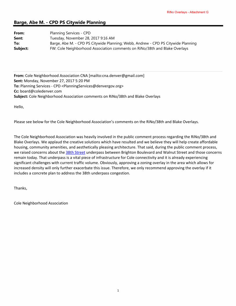
1
Barge, Abe M. - CPD PS Citywide Planning
From: Planning Services - CPDSent: Tuesday, November 28, 2017 9:16 AMTo: Barge, Abe M. - CPD PS Citywide Planning; Webb, Andrew - CPD PS Citywide PlanningSubject: FW: Cole Neighborhood Association comments on RiNo/38th and Blake Overlays
From: Cole Neighborhood Association CNA [mailto:[email protected]] Sent: Monday, November 27, 2017 5:20 PM To: Planning Services ‐ CPD <[email protected]> Cc: [email protected] Subject: Cole Neighborhood Association comments on RiNo/38th and Blake Overlays Hello,
Please see below for the Cole Neighborhood Association’s comments on the RiNo/38th and Blake Overlays.
The Cole Neighborhood Association was heavily involved in the public comment process regarding the RiNo/38th and Blake Overlays. We applaud the creative solutions which have resulted and we believe they will help create affordable housing, community amenities, and aesthetically pleasing architecture. That said, during the public comment process, we raised concerns about the 38th Street underpass between Brighton Boulevard and Walnut Street and those concerns remain today. That underpass is a vital piece of infrastructure for Cole connectivity and it is already experiencing significant challenges with current traffic volume. Obviously, approving a zoning overlay in the area which allows for increased density will only further exacerbate this issue. Therefore, we only recommend approving the overlay if it includes a concrete plan to address the 38th underpass congestion.
Thanks,
Cole Neighborhood Association
RiNo Overlays - Attachment G

1
Barge, Abe M. - CPD PS Citywide Planning
Subject: FW: City Council, Dist. 9 Request - FW: Official Map Amendment Land Use, Transportation and Infrastructure Public Meeting Notification #2017I-00122 38th and Blake Station Area Underlying Zone District Rezoning/Application of Overlay Districts
From: Yahoo [mailto:[email protected]] Sent: Saturday, December 23, 2017 9:52 AM To: Montoya, Chy ‐ City Council District 9 <[email protected]> Cc: Barge, Abe M. ‐ CPD PS Citywide Planning <[email protected]>; [email protected] Subject: Re: City Council, Dist. 9 Request ‐ FW: Official Map Amendment Land Use, Transportation and Infrastructure Public Meeting Notification #2017I‐00122 38th and Blake Station Area Underlying Zone District Rezoning/Application of Overlay Districts This email will serve as a letter of support and I am out of the country. Our board members have been informed and are very supportive of zoning overlay and the positive impact this has our community. Sent from my iPhone
RiNo Overlays - Attachment G

2901 Blake Street • Suite 165 • Denver, Colorado 80205 • 720.507.4776 • rinoartdistrict.org
artwork by @rather_severe w/rum tum
12/29/2017
RiNo Art District 2901 Blake Street STE 165 Denver, Colorado 80205
Council President Albus Brooks and Members of Denver City Council City and County Building 1437 Bannock St. Denver, CO 80202
Dear Council President Brooks and Members of Denver City Council:
I am writing to you today, on behalf of the entire RiNo Art District organization, to express our support for the 38th and Blake Station Area Underlying Zone District Rezoning and Application of Overlay Districts, and ask that you support this proposed rezoning package.
RiNo has been a leader alongside Councilman Albus Brooks and our surrounding neighborhoods in exploring an increase in density around the 38th and Blake Street commuter rail station. Our focus has been on creating a path to allow development to happen in a way that does not harm our neighborhood fabric, but rather contributes to it, providing affordable housing and commercial space and creating a more design-friendly, walkable and accessible district.
We feel the process to come to this point has been well thought-out, inclusive and transparent and has helped to educate stakeholders on both the impacts and opportunities associated with increasing density while giving them a voice in shaping the outcomes based upon what is most critical to each of us.
The preferred approach, which you are being asked to support, provides a vision for the 38th and Blake Street area that includes higher density as well as a vibrant, walkable and economically diverse transit-oriented development (TOD) station area. We believe the increased density, which pushes beyond the height limits set by previous plans, will provide a number of community benefits for RiNo and surrounding areas, including but not limited to:
▪ Density that is appropriate for a TOD area and that will accommodate the growth of both Denver and our district
▪ Higher quality building design that supports taller buildings while ensuring it is at a scale that is comfortable for pedestrians, improving the overall public realm experience
▪ Supporting uses and design features that encourage walking and bicycling over use of the automobile
▪ Ground level active uses that can support the continued growth of creative and community serving uses as well as retail and restaurant spaces to serve the neighborhood
▪ Mass reduction of buildings that provide for increased light and air even as density increases
RiNo Overlays - Attachment G

2
▪ Minimizing parking visibility and impacts
Additionally, RiNo has strongly advocated for the integration of on-site affordability within the station area, requiring that increased density for developers translates into a requirement that developers accommodate affordable housing and commercial opportunities for the growing workforce and creative community that is needed city-wide but also within our quickly changing district. We believe that the growth of a diverse and mixed-income district is critical and that putting these affordable uses near the station area is particularly important because it also will ideally have the added effect of reducing reliability on automobile travel.
Finally, the rezoning and overlays provide for critical investments and improvements to the entire RiNo district which will support the station area as well as connectivity to it. This includes putting a focus on the South Platte River and the creation of an active and vibrant riverfront experience with buildings and pedestrian amenities. The additional improvements to the public realm which we feel are essential to achieve a walkable TOD area with less automobile use include:
▪ Converting Downing and Marion to 2-Way streets ▪ Addressing the 38th & Blake Underpass ▪ Adding bike lanes and facilities ▪ Completing pedestrian / bike connections between parks and the river We look forward to working alongside the City of Denver to implement the proposed rezoning and overlays, and we hope you will support this process too.
Regards,
Jamie Licko President, RiNo Art District
CC: Andrew Feinstein, RiNo Art District Co-Chair (also RiNo Business Improvement District) Chandler Romeo, RiNo Art District Co-Chair Justin Croft, RiNo Business Improvement District Chair (also RiNo Art District) Anne Hayes, RiNo General Improvement District Chair (also RiNo Art District)
RiNo Overlays - Attachment G

RiNo Overlays - Attachment G

RiNo Overlays - Attachment G
2/6/2018 RiNo Art District 2901 Blake Street STE 165 Denver, Colorado 80205 Council President Albus Brooks City and County of Denver 1437 Bannock Street Denver, CO 80302 Dear Council President Brooks, Members of the Executive Committee of the RiNo Art District have recently been in conversations with Jon Dwight who is developing a mixed-use project at 34th and Walnut. It is our understanding that he is in the midst of discussions with the City and County of Denver regarding the incentive overlay slated to go to Denver City Council on Monday, February 12. Here is our understanding of Mr. Dwight’s situation: ▪ The housing component of the project Mr. Dwight is planning is 100% for-sale ▪ Per the proposed incentive overlay, Mr. Dwight would be required to build eight (8) for
sale affordable units at 80% AMI (median income to qualify = $47,000) ▪ Mr. Dwight is challenging how the incentive overlay works with for-sale product because
of the higher cost of development of for-sale product. Mr. Dwight’s suggestion/offer to the City and County of Denver is to create an agreement with Medici/Urban Land Conservancy (ULC) to build his required affordable units in their planned development at 38th and Blake, as opposed to him building it within his project. Mr. Dwight would pay Medici/ULC to build seven (7) additional affordable units in their development, doubling the number of affordable units in the Medici/ULC development from seven (7) to fourteen (14), all built at 30% AMI (median income to qualify for 30% AMI = $17,650)
▪ The City and County of Denver is currently telling Mr. Dwight this is not possible. Their reasoning is that because he’s doing for sale product, he must do affordable for-sale product as part of the incentive overlay, not trade out for affordable rental products
The RiNo Art District Executive Committee would like to respectfully ask that the City of Denver reconsider this position. It is our belief that having a total of fourteen (14) affordable rental units at 30% AMI right at the 38th and Blake Commuter Rail Station is as powerful if not more powerful than having eight (8) for-sale units at 80% AMI a few blocks from the station. During the development of the rezoning and overlay process the last two-plus years, members of the RiNo Art District Executive Committee requested that the City explore excluding for-sale units from the incentive overlay, specifically to incentivize developers to
RiNo Overlays - Attachment G

build them. It is our feeling that doing so may actually create more for-sale product in the RiNo Art District. For-sale developers face significant hurdles to get a project built within our current legislative and economic situation, and we want to do what we can to support the development of for sale units. Moreover, a cash infusion into an affordable project enables that project to offer additional varying levels of AMI – something we need to preserve the socioeconomic diversity of RiNo. Our executive committee debated this matter thoroughly and acknowledge there is no perfect solution. We recognize fully that home ownership is the path to stability in our City - that If we have all rentals and no affordable for-sale units, we will continue to have rental churn and less stability and economic diversity in RiNo. But we also acknowledge the need for lower AMI units is great and difficult to provide even in purely affordable projects for sale or for rent. The benefit of providing seven more 30% AMI units to the neighborhood is significant, and can provide new housing opportunities to artists and the influx of workers needed to support our growing hotel, restaurant and beverage-production economy. We have come to the conclusion, as a group, that supporting Mr. Dwight’s request – and potentially future requests like it – will actually increase ownership, otherwise he and others will be incentivized to build apartments as well. To that end, beyond this specific project, we would like the City and County of Denver to reconsider the big picture goals of the incentive overlay and look at the impacts and opportunities associated it as it relates to both for sale and for rent products and the ability for developers to collaborate to deliver a diversity of housing. We urge you to consider our collective input on this matter as part of Council’s deliberations on February 12th. Thank you for your consideration. Regards, RiNo Art District Executive Committee Jamie Licko, President Andrew Feinstein, RiNo Art District Co-Chair Chandler Romeo, RiNo Art District Co-Chair Justin Croft, RiNo BID Chair, RiNo Art District Board Member Anne Hayes, RiNo GID Chair, RiNo Art District Board Member CC: Councilwoman Robin Kniech, At-Large
Councilwoman Deborah Ortega, At-Large Alan Salazar, Chief of Staff Brad Buchanan, Executive Director, Denver Community Planning and Development Abe Barge, Principal City Planner, Denver Community Planning and Development Andrew Webb, Senior City Planner, Denver Community Planning and Development Jon Dwight
RiNo Overlays - Attachment G

To: CouncilmanAlbusBrooks,District9AbeBarge,CommunityPlanningandDevelopment
LauraBrudzynski,OfficeofEconomicDevelopmentFrom: CharlesStreetPartners TributaryRealEstateDate: June30,2017Re: Landownercommentsre:38th&BlakeaffordablehousinganddesignoverlaydistrictsCharlesStreetPartnersandTributaryRealEstatehavebeeninvolvedintheplanningprocessandstakeholderoutreachforthe38thandBlakestationareasincebeforetheheightamendmentprocessbeganinNovember2015.Fromattendingthefirstandallsubsequentmeetingsontheheightamendments,toproactiveoutreachtoCityCouncilandCPD,toattendingaseriesofstakeholdermeetingsontheoverlaydistricts(latestmeeting,April10,2017),wehaveandwillcontinuetobeanactiveparticipantinalldiscussionsduetothelargeamountoflandweownandhaveundercontract.BasedontheApril10stakeholdermeeting,weunderstoodtheCitywaspreparingtoengagefinancialfeasibilityconsultantstotestthedraftconceptsoftheaffordablehousinganddesignoverlaydistricts.BasedonMay31emailcorrespondence,weunderstoodtheCityisrunningbehindscheduleonengagingthefeasibilityconsultant(s)andassuch,theoverallprocessisalsorunningbehind.AstheCityproceedstoanalyzetheavailableoptions,wewantedtoprovideinwritingsomeofthecommentswehavesharedthroughouttheprocess,sothattheCitycanconsiderthemasitmovesforwardwiththeanalysis,draftingandfeasibilitytestingoftheproposedoverlaydistricts.ThesecommentsarebasedonthemostrecentproposaldiscussedattheApril10stakeholdermeeting.Affordableoverlay:
1. Implementasquarefootagecalculationonthe"buildoption"thatresultsin"X"grosssquarefeet(SF)ofaffordable(notaspecificnumberofunits).Developermayelecttofillup"X"grossSFwithanycombinationofunits,providedthat"X"grossSFisaffordable.Thisisanimportantwaytopromotesomeflexibility,whilealsoensuringanequitabledegreeofaffordability.Forexample,adevelopercouldelecttoprovideagreaternetnumberofaffordableunits,withsmallersquarefootages,orfewerunits,butwithlargersquarefootagesthatcouldaccommodatefamiliesnearthelightrailstation,whichweunderstandtobeaprioritygoalfortheCity.
2. Inordertomeetrequirementsrelatedto“communityservingbusinesses,”considerlanguageto
grandfatherorprovidecreditincaseswhereadeveloper/ownerhasrecentlysoldoffsitestoqualifyingcommunityservingbusinesseswithinthestationareapriortotheoverlaydistrictbecomingeffective.Withnopriorknowledgeofthisrequirement,ourownershipgrouprecentlysoldofftwositesatlowerthanmarketratestoqualifyinggroceryandcommunitybankusesinthestationareaat3757BrightonBlvd(NaturalGrocers)and3655BrightonBlvd(CollegiatePeaksBank).Wehelpeddeliver
RiNo Overlays - Attachment G

thesetwousestobeagoodstewardfortheneighborhoodandtoprovideexactlywhattheCityandcommunitywerelookingforfromacommunityservingbusinessstandpoint.ThisisanewrequirementthattheCityhasneverrequiredpreviously.Thisisalsonotaneasyrequirementtodeliverduetoahostofcomplexitiesinthecommercial/leasingworld.Assuch,westronglyencourageCPD/OEDtoconsiderflexibilityandgrandfatheringincaseswhereanowner/developerhasprovidedsuchqualifyingusesintherecentpast.TheCommunityBenefitsAgreement(CBA)mentionedintheCity’sdrafttextprovidesaframeworkforhowthiscouldbeaccommodated.
3. Themandateofthebuildoptionforevenbasestoryheightsisanewrequirementandmandate.
Effectively,byrequiringbuildonly,evenforbaseheights,andeliminatingtheoptiontopayafee-in-lieu,developersandpropertyownerswithinthenewoverlaydistrictareatadisadvantageandarebeingtreateddifferentlyfromeveryotherpropertyownerintheCityundertherecentlyadoptedaffordablehousingordinance.
WhilewerecognizethattheCity’sgoalwiththisproposalistoensurethatactualunitsgetbuilt,byimposingthisrequirementevenonbaseheights,theCityistakingawayarightthatpropertyownersotherwisehave.Thisraisesavarietyoflegalissues,whichcouldultimatelyhampertheabilityoftheCitytorealizeitsgoalsinthisarea.GiventhefundamentalpremiseofvaluecapturearticulatedbytheCity,isappropriatetoapplyheightenedstandardstotheadditionaldensitymadeavailablebytheoverlaystructure,butitisnotappropriatetoapplyheightenedstandardstobasedensitiesthatalreadyexistbyrightunderthecurrentzoningscheme.
Designoverlay:
4. Eliminateorconsideralternativecomplianceoptionsforthewraprequirementforstructuredparkingandactivegroundfloorusesfornon-BrightonBlvdaddresses.Again,weunderstandthattheCity’sgoalwiththisrequirementistocreatepedestrianfriendlyspaces,andawalkableneighborhood.However,giventhewidevarietyoflotsizesandshapesinthestationarea,andtheevenwidervarietyofbothexistingandproposedarchitectureandconstructionmethods,itispossibletocreateinteractivespacesusingavarietyoftechniques.Strictadherencetothisrequirementisnotlikelytoproducethedesiredeffect,andcouldsimplydampeninvestment,limitcreativity,andreducenewconstructioninthisarea.
Feasibilitytesting:
5. AstheCitycommencesfeasibilitytestingoftheaffordableanddesignoverlaysandtheirrequirements,wesuggesttheCityandtheirconsultantworkwithandsolicitfeedbackownersanddeveloperstoensurethatthesenewrequirementsarepracticalandachievableandwedon’tcreateunintendedconsequences.Wehaveafullunderwritingteamwithonthegroundknowledgeofland,useandmarketconditionsandinfrastructurecosts.Understandinghowtheseprojectsareanalyzedandunderwrittenforfinancialfeasibility,andhowtheyarefinanced,couldhelptheCityunderstandthepotentialimpactsofvariousalternatives,andthelikelihoodthattheywillproducethedesiredresult.AsseveralpropertyownerscommentedintheApril10meeting,iftheadditionaldensityavailableundertheoverlayistoocostlytoprojects’bottomlines,theentireareawillsimplybedevelopedwithbasedensitieswhichwillnotachievetheCity’soverallgoals.
RiNo Overlays - Attachment G

Thankyouforyourcontinuedworkwithourownershipteamandtheownershipteamsfromotherstakeholderinthisarea.Whileweallwanttocreatethebestplaceandneighborhood,wealsoneedtobecarefulnottounnecessarilylimitmarketdesirabilitylestthesenewrequirementsresultintheoppositeofthedesiredoutcomes.
RiNo Overlays - Attachment G

6950 South Potomac St, Suite 100
Centennial, CO 80112
November 17, 2017
Abe Barge, Principal City Planner
Community Planning and Development
City and County of Denver
201 W. Colfax Ave
Denver, CO 80202
Re: Comments on Denver Zoning Code Text Amendment #2, Public Review Draft 10/20/17
Dear Abe;
Thank you for your time on November 2. Below are our comments on the 10/20/17 Public Review Draft
subsequent to that meeting. All section references are within 9.4.5.11.
• F.1.c indicates the City’s intent to push for vehicle access to the alley except when infeasible, and
acknowledges that the City is working on the language to support this. Per our meeting, we understand that
Public Works will have broad discretion on this item. Specifically as it relates to our proposed project @ 3695
Wynkoop (which includes a 500 space parking garage) as indicated by Luke Korpi at our SDP Concept meeting
on 9/28/17, pushing this many cars into the alley at the end of the work day qualifies as infeasible and access
to/from Wynkoop is approved.
• It is possible for specific property owners to opt-out of the rezone, but not of the overlay. That said, the
overlay does not apply to certain existing zones (eg I-B), and so would have no implications on these
properties until/unless they were eventually rezoned to an affected zoning designation.
• Parts of sections F & G address Build-To & Activation requirements. As it stands, new development must
build-to at least 70% of the Zone Lot Width. It is not permissible to build a 60’ wide building on a 100’ wide
zone lot. Neither is it permissible to extend an existing 40’ wide building on a 100’ wide zone lot to 60’. We
suggested that this is a troubling requirement. Although today’s economic and development climate makes it
likely that property owners will want to build at least 70% of the width of their property, this will not always
be the case. This requirement may lead to requests to divide parcels to allow for smaller development.
• We clarified that the intent of the overlay is that at least 70% of the zone lot width must be “activated” within
the build-to zone, and at least 70% of the required activation must be approved non-residential use. An open
parking garage entry, if built-to, counts as activation.
• We clarified that the intent of the overlay is that at least 50% of the “Street Facing Building Façade” must be
“transparent”. Transparency is measured in linear feet, not square feet. An open parking garage entry, and
an open-sided parking garage at grade count as transparent.
• We confirmed that if a parking structure does not meet the height thresholds noted in E.4 & F.2.b, then no
screening of any kind is required for above grade parking.
RiNo Overlays - Attachment G

• E.4 & I.2.b address volumetric mass reduction. The goal of the overlay is to address MASS, not SQUARE
FOOTAGE, but the overlay is using square footage as a proxy for mass. As we discussed, the City will consider
defining square footage, for the purposes of mass reduction, as enclosed or covered space. This is important
because of projects like the one we have proposed at 3695 Wynkoop, which is a 5 story parking structure with
no roof on the 5th level, giving it the equivalent volumetric mass impact of a 4 story office building. As a
result, we agreed that the volumetric mass requirement would not apply to our proposed structure.
• From our conversation, we understand that City Staff supports rezoning 3695 Wynkoop to I-MX-5 rather than
C-MX-5, and that this needs to be finalized with Councilman Brooks.
• Given that the volumetric mass reduction and incentive height linkage fees are tied to square footage on
specific floors of the building, we discussed the need for the City to define where one floor stops and the next
begins for sloped floors (as with the ramping in our proposed parking structure). We suggested using the
existing City definition from 13.1.2.3.B that says if the floor above you is at least 12’ above grade, then you are
on the first floor. This would dictate that the second floor begins when the ramp gets 12’ above grade, and
subsequent floors would follow suit.
• I.2.a.iii.a places a requirement on the clear height from the finished floor to the ‘ceiling’ of the interior space
along the street-facing street-level space. We made 3 suggestions.
o It will be difficult for core/shell developers to prove compliance to this requirement. As a result,
consider changing the requirement so that it measures to points within the structure, rather than to
finishes.
o Within these requirements, the City needs to provide guidance for compliance on sloped sites, where
the street-level may have a stepped slab elevation but where the 2nd floor is flat all the way across the
site.
o Perhaps also create a set of requirements for review of tenant finish applications. Nationwide, and in
Denver, most urban, street-facing, street-level, active retail has at least some area of finished ceiling
that is lower than 14’, and this is not inconsistent with the City’s vision for the neighborhood.
Examples are entry areas with lowered ceilings, feature bar areas along exterior walls, and soffits at
cash registers. The City will need to determine a way to allow appropriate implementation of these
types of features, perhaps on a % basis that can be lower than 14’
We welcome the opportunity to continue to engage in the City’s process. Please let us know if we have mis-
stated anything, and/or if we can provide additional information.
3600 BRIGHTON BLVD LLC
By_________________________
Jerry Blocher
Director of Development
RiNo Overlays - Attachment G

RiNo Overlays - Attachment G

RiNo Overlays - Attachment G

RiNo Overlays - Attachment G

RiNo Overlays - Attachment G

RiNo Overlays - Attachment G

RiNo Overlays - Attachment G

1
Barge, Abe M. - CPD PS Citywide Planning
Subject: FW: 38th and Blake Height Overlay Zone
From: Dick Farley [mailto:[email protected]] Sent: Wednesday, December 06, 2017 8:46 AM To: Rezoning ‐ CPD <[email protected]> Cc: dick@rf‐urbandesign.com Subject: 38th and Blake Height Overlay Zone A bonus height for commercial projects should not be given for ‘needed’ retail uses such as grocery stores, drug stores, etc. Let the market decide that. Don’t even list them as possible uses to be considered. Limit the uses that trigger bonus height to only affordable, subsidized maker/art studios, live/work/cooperative art studios and galleries, and art‐related non‐profits (not any old non‐profits). The art studios and maker spaces are what have been gentrified out of the neighborhood. Those are the uses that have given the neighborhood its identity and cache. Entice them back in with the height / density bonus. Thank you, Dick Farley, RiNO resident and artist
RiNo Overlays - Attachment G

From: Barge, Abe M. - CPD PS Citywide PlanningTo: Elisabeth TeaterCc: Webb, Andrew - CPD PS Citywide Planning; Brudzynski, Laura R. - OED BHS AdministrationSubject: Re: 38 & BlakeDate: Thursday, January 25, 2018 9:36:08 AM
Hi Elisabeth,
Thanks for the message. I’ve provided some information in response to your questions andfeedback below. A key point is that residential projects using the incentive at 38th and Blakewill have to build affordable housing units with no option to pay a fee.
Yes - Developers would have to make significantly greater contributions towardaffordable housing when building incentive height around the 38th and Blake Stationthan is required for construction elsewhere in the city.
Affordable to households earning 80% of AMI: This is the threshold that was definedfor ‘build alternative units’ (affordable units built instead of paying a fee) for thecitywide affordable housing linkage fee that went into effect at the beginning of 2017after a significant public process. The incentive system at 38th and Blake would use thesame framework as the citywide system. Some additional information:
Market rate residential units in new construction are generally priced significantlyabove the threshold for affordability at 100% AMI (especially in central Denver),so units provided at 80% AMI are tend to be significantly subsidized. Note that 40-50% of resources from the new citywide Affordable Housing Fund(the fund that collects linkage fees - see below) will be invested to serve peopleearning below 30% of AMI and those experiencing homelessness who are seekingto access or maintain rental housing. I’ve copied Laura Brudzynksi at the Office of Economic Development in case shehas additional background to provide on use of the 80% AMI threshold.
Fees/fines vs. provision of affordable units: Here’s a summary of the proposedrequirements when building incentive height at 38th and Blake:
Residential or primarily residential buildings: When building market rateresidential, developers would NOT have the option to pay fees as they doelsewhere in the city. They would be required to build affordable residential unitsin their project or nearby. The unit requirement would five times the citywide unitrequirement for the taller portion of the building. This summary documentincludes examples. In other parts of the city, developers have the option to buildunits (with a much lower requirement) or pay a fee (they almost always pay thefee instead). Again, the fee would not be an option for residential buildings at38th and Blake.Commercial or primarily commercial buildings: Because it can be challenging toprovide residential units as part of these projects, they have additional options:
Build affordable units (at five times the citywide requirement for floor area
RiNo Overlays - Attachment G

above the allowed base height)Provide community-serving uses such as space for arts organizations orcommunity non-profits (these projects would still have to pay the normalcitywide fee for affordable housing)Pay a fee (at five times the citywide fee for floor area above the allowedbase height)
Fees: Any fees paid would go into the Citywide Affordable Housing Fund and/or asimilar Affordable Housing Incentive Fund.
The money contributed to these funds must be used to create and preserveaffordable housing in Denver and can’t be used for other programs.This draft plan provides additional information on how the city plans to use fundresources (including the plan to invest 40-50% of fund resources to serve peopleearning below 30% of AMI and those experiencing homelessness who are seekingto access or maintain rental housing).
Additional information:Web page with info on 38th and Blake Zoning OverlaysWeb page with info on the Citywide Affordable Housing FeeWeb page with info on affordable housing programs in general
I hope the information above helps. Please let us know if you have additional questions orfeedback. We appreciate your comments!
Regards,
-Abe
Abe Barge | Principal City PlannerCommunity Planning and Development | City and County of Denverp: (720) 865-2924 | [email protected]/CPD | @DenverCPD | Take our Survey
On Jan 23, 2018, at 8:01 PM, Elisabeth Teater <[email protected]>wrote:
Hello,
I would like to address a concern that I have with the buildings going up at Blake& 38th.
I understand that developers will get incentives if they build affordable housing?
RiNo Overlays - Attachment G

Why is "affordable" defined as 80% Ami? It is my desire that it would be definedat 50% Ami or less. Otherwise I do not think incentives should be offered. Also,I want to make it clear that I do not think that developers should have the optionof paying a fine instead of building affordable units.
An additional question: if developers currently opt to pay a fine instead ofoffering affordable units, where does that money go?
Thanks!
Elisabeth Teater, homeowner,3328 Williams, Denver 80205
RiNo Overlays - Attachment G