concept note - lestari-indonesia.org · built on the strong foundation of usaid’s ifacs project,...
TRANSCRIPT
CONCEPT NOTE
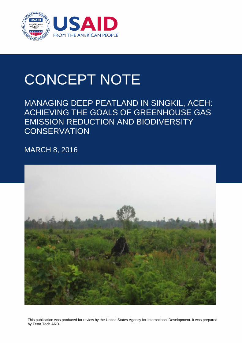
MANAGING DEEP PEATLAND IN SINGKIL, ACEH: ACHIEVING THE GOALS OF GREENHOUSE GAS EMISSION REDUCTION AND BIODIVERSITY CONSERVATION
MARCH 8, 2016
This publication was produced for review by the United States Agency for International Development. It was prepared by Tetra Tech ARD.
This publication was written by Matthew Linkie, Muhamad Muslich, Matthew Leggett, and Willy Marthy of WCS and supported by the USAID LESTARI program. This publication was prepared for review by the United States Agency for International Development under Contract # AID-497-TO-15-00005. The period of this contract is from July 2015 to July 2020. Implemented by: Tetra Tech P.O. Box 1397 Burlington, VT 05402
USAID LESTARI Concept Note: Managing Deep Peatland In Singkil, Aceh: Achieving The Goals Of Greenhouse Gas Emission Reduction And Biodiversity Conservation – March 8, 2016
P a g e | 1
CONCEPT NOTE
MANAGING DEEP PEATLAND IN SINGKIL, ACEH: ACHIEVING THE GOALS OF
GREENHOUSE GAS EMISSION REDUCTION AND BIODIVERSITY CONSERVATION
MARCH 8, 2016
DISCLAIMER
This publication is made possible by the support of the American People through the United States Agency for International Development (USAID). The contents of this publication are the sole responsibility of Tetra Tech ARD and do not necessarily reflect the views of USAID or the United States Government.
USAID LESTARI Concept Note: Managing Deep Peatland In Singkil, Aceh: Achieving The Goals Of Greenhouse Gas Emission Reduction And Biodiversity Conservation – March 8, 2016
P a g e | 2
TABLE OF CONTENTS
Executive Summary ............................................................................................................ 3
Ringkasan Eksekutif ........................................................................................................... 5
Introduction ......................................................................................................................... 7
Peatland In Indonesia ......................................................................................................... 8
Peat swamp forests ............................................................................................................................. 8 Peatland and fire ................................................................................................................................. 8 National law and peat management initiatives.................................................................................... 9
Environmental Services and Peatland in Aceh ............................................................... 11
The economics of maintaining Aceh’s forest ecosystem .................................................................. 11 Peat swamp forest in Aceh ............................................................................................................... 12
Situation Analysis of Singkil Wildlife Reserve ................................................................ 14
Carbon sequestration value .............................................................................................................. 14 Biodiversity value .............................................................................................................................. 15 Agricultural clearance and fires ......................................................................................................... 16 Illegal logging .................................................................................................................................... 18 Management status ........................................................................................................................... 18 National and subnational initiatives ................................................................................................... 20 International support ......................................................................................................................... 20
Objectives and Actions .................................................................................................... 21
Objective 1. Increase management effectiveness of Singkil Wildlife Reserve to protected peat forest and wildlife......................................................................................................................................... 21 Objective 2. Assess and monitor the ecosystem service benefits provided by Singkil Wildlife Reserve ............................................................................................................................................. 22 Objective 3. Investigate illegal supply chains for palm oil and timber in forest and peatland areas in Aceh Selatan, Subulussulam, and Singkil which present a high future fire risk to Aceh’s forests and biodiversity. ....................................................................................................................................... 23 Objective 4. Assess the financial incentives which currently drive forest clearance on peatlands in Aceh, at district, provincial and national levels, to build a business case for sustainable land use. 24
Conclusion ........................................................................................................................ 25
USAID LESTARI Concept Note: Managing Deep Peatland In Singkil, Aceh: Achieving The Goals Of Greenhouse Gas Emission Reduction And Biodiversity Conservation – March 8, 2016
P a g e | 3
EXECUTIVE SUMMARY This report provides a brief yet informative analysis of the crucial role of peatlands in the ecosystems of Aceh Province, Indonesia. Peat forests contain some of the highest carbon stocks per hectare of any forest, and hence their protection must be a priority of the Government of Indonesia’s greenhouse gas emissions reduction strategy. However, the devastating 2015 Indonesian fire and haze event resulted largely from irresponsible peatland management and shows that Indonesia’s peatlands are under threat. This holds serious consequences for the health, economy, climate, and biodiversity of the region. Aceh contains three main peat swamp forests: Tripa, Singkil, and Kluet. Tripa demonstrates how quickly a deep peatland can be degraded by illegal oil palm encroachment and the systematic use of fire to clear forested land. The two remaining deep peat forests, Singkil and Kluet, are both are still relatively intact but are under threat from illegal oil palm and logging interests. The ongoing illegal drainage, degradation, and conversion of Singkil and Kluet greatly heighten the risk of widespread fires across much of the western Leuser Ecosystem. The experience from Tripa shows that a proactive and pre-emptive approach is critical for avoiding fires. The Situation Analysis presented in this report reveals several key gaps that undermine efforts to safeguard Singkil Wildlife Reserve and Aceh’s other peat swamp forests – the low management capacity of BKSDA, lack of actionable information on illegal oil palm and timber supply chains, lack of transparency on the status of existing concessions, and poor knowledge of district government on land use planning policies and laws. To address this, a multi-layered approach is proposed, consisting of the following 4 objectives:
Objective 1. Increase management effectiveness of Singkil Wildlife Reserve to protected peat forest and wildlife
Objective 2. Assess and monitor the ecosystem service benefits provided by Singkil Wildlife Reserve
Objective 3. Investigate illegal supply chains for palm oil and timber in forest and peatland areas in Aceh Selatan, Subulussulam, and Singkil which present a high future fire risk to Aceh’s forests and biodiversity.
Objective 4. Assess the financial incentives which currently drive forest clearance on peatlands in Aceh, at district, provincial and national levels, to build a business case for sustainable land use.
In order to preserve Singkil and its ecosystem services, a range of actions involving government partners at all levels is required. Hence LESTARI can play a key leadership role in coordinating and supporting the work of district, provincial, and national level government agencies. For instance, LESTARI can support the production of a detailed national peatland map, improved technical guidance for peatland governance and ecosystem restoration, and strengthened community-based fire monitoring systems. These efforts must be complemented through provincial and district-level support for enhanced protected area management capacity, community-based incentive schemes, and, especially for Singkil, preventing encroachment into reserve boundaries.
USAID LESTARI supports the Government of Indonesia (GoI) to reduce greenhouse gas (GHG) emissions and conserve biodiversity in carbon rich and biologically significant forest and mangrove ecosystems. Built on the strong foundation of USAID’s IFACS project, LESTARI applies a landscape approach to reduce GHG emissions, integrating forest and peatland conservation with low emissions development (LEDS) on other, already degraded

USAID LESTARI Concept Note: Managing Deep Peatland In Singkil, Aceh: Achieving The Goals Of Greenhouse Gas Emission Reduction And Biodiversity Conservation – March 8, 2016
P a g e | 4
land. This is achieved through improved land use governance, enhanced protected areas management and protection of key species, sustainable private sector and industry practices, and expanded constituencies for conservation among various stakeholders. LESTARI is implemented under the leadership of Tetra Tech and a consortium of partners including WWF-Indonesia, Winrock International, Wildlife Conservation Society (WCS), Blue Forests, Yayasan Sahabat Cipta, PT Hydro South Pole Carbon, Sustainable Travel International (STI), Michigan State University, and the FIELD Foundation. LESTARI runs from August 2015 through July 2020.
USAID LESTARI Concept Note: Managing Deep Peatland In Singkil, Aceh: Achieving The Goals Of Greenhouse Gas Emission Reduction And Biodiversity Conservation – March 8, 2016
P a g e | 5
RINGKASAN EKSEKUTIF Laporan ini menyajikan analisis singkat dan informatif dari peran penting lahan gambut dalam berbagai tipe ekosistem di Propinsi Aceh, Indonesia. Hutan gambut mengandung sebagian dari stok karbon tertinggi per hektar-nya dibandingkan tipe hutan lain, dan dengan demikian perlindungan hutan gambut harus menjadi prioritas dari strategi Pemerintah Indonesia dalam penurunan emisi gas rumah kaca. Akan tetapi, kejadian kebakaran dan asap yang luar biasa pada tahun 2015 di Indonesia paling banyak disebabkan oleh pengelolaan lahan gambut yang tidak bertanggung jawab dan menunjukkan ancaman yang signifikan terhadap lahan gambut di Indonesia. Kejadian tersebut menimbulkan konsekuensi yang serius terhadap kesehatan, ekonomi, iklim dan keanekaragaman hayati di wilayah terbakar. Aceh memiliki tiga hutan rawa gambut utama: Tripa, Singkil, dan Kluet. Kawasan Tripa menunjukkan bagaimana cepatnya lahan gambut dalam mengalami degradasi akibat perambahan liar kelapa sawit dan penggunaan api yang sistematis untuk membersihkan lahan berhutan. Dua hutan gambut dalam yang tersisa, Singkil dan Kluet, masih terbilang utuh tetapi terancam oleh kepentingan kelapa sawit ilegal dan pembalakan. Konversi, degradasi, dan drainase ilegal yang terus berlangsung di Singkil dan Kluet meningkatkan risiko kebakaran yang meluas di bagian barat Ekosistem Leuser. Pengalaman dari Tripa menunjukkan bahwa pendekatan proaktif dan preemptive sangat penting guna menghindari kebakaran. Analisis Situasi yang disajikan dalam laporan ini mengungkapkan beberapa gap atau kesenjangan utama yang menghambat upaya-upaya untuk menyelamatkan Suaka Margasatwa Rawa Singkil dan hutan rawa gambut di Aceh lainnya – kapasitas sumberdaya yang kurang tersedia bagi manajemen BKSDA, tata batas kawasan yang kurang jelas, kurangnya informasi taktis tentang rantai pasok perkebunan kelapa sawit dan industri kayu ilegal, kurangnya transparansi terkait status konsesi-konsesi yang ada saat ini, dan rendahnya pengetahuan pemerintah daerah tentang kebijakan dan peraturan perencanaan tata guna lahan. Untuk mengatasi permasalahan ini, suatu pendekatan multi lapis diusulkan, yang terdiri dari 4 tujuan berikut ini:
Tujuan 1. Meningkatkan efektivitas pengelolaan Suaka Margasatwa Rawa Singkil untuk perlindungan hutan gambut dan hidupan liar
Tujuan 2. Mengkaji dan memonitor manfaat jasa ekosistem yang disediakan oleh Suaka Margasatwa Rawa Singkil
Tujuan 3. Menginvestigasi rantai pasok ilegal untuk kelapa sawit dan industri kayu di kawasan hutan dan lahan gambut di Aceh Selatan, Subulussulam, dan Singkil yang dapat menyebabkan resiko kebakaran yang tinggi di masa depan untuk hutan dan keanekaragaman hayati di Aceh.
Tujuan 4. Mengkaji insentif ekonomi yang saat ini mendorong terjadinya pembukaan hutan pada lahan gambut di Aceh, baik di tingkat kabupaten, propinsi dan nasional, guna membangun skenario bisnis bagi pemanfaatan lahan berkelanjutan.
Guna melestarikan Singkil dan jasa ekosistemnya, diperlukan berbagai aksi yang melibatkan mitra pemerintah di berbagai level. Oleh karena itu, LESTARI dapat memainkan peran kunci untuk mengkoordinasikan dan mendukung kerja-kerja institusi pemerintah di tingkat kabupaten, propinsi, dan nasional. Sebagai contoh, LESTARI dapat mendukung pembuatan peta detil lahan gambut nasional, memperbaiki petunjuk teknis untuk tata kelola lahan gambut dan restorasi ekosistem, dan memperkuat sistem monitoring kebakaran berbasis masyarakat. Upaya-upaya ini harus dilengkapi dengan dukungan di tingkat kabupaten dan propinsi untuk meningkatkan kapasitas pengelolaan kawasan lindung, skema insentif
USAID LESTARI Concept Note: Managing Deep Peatland In Singkil, Aceh: Achieving The Goals Of Greenhouse Gas Emission Reduction And Biodiversity Conservation – March 8, 2016
P a g e | 6
berbasis masyarakat, dan khususnya untuk Singkil, mencegah perambahan ke dalam kawasan. Potensi dukungan ini sesuai dengan kerangka teknis projek LESTARI. Proyek USAID LESTARI mendukung upaya Pemerintah Republik Indonesia (RI) menurunkan emisi gas rumah kaca (GRK), melestarikan keanekaragaman hayati di ekosistem hutan dan mangrove yang bernilai secara biologis serta kaya akan simpanan karbon. Dibangun diatas pondasi proyek USAID IFACS, LESTARI menerapkan pendekatan lanskap untuk menurunkan emisi GRK, dengan mengintegrasikan aksi konservasi hutan dan lahan gambut dan strategi pembangunan rendah emisi (SPRE) di lahan lain yang sudah terdegradasi. Upaya ini dicapai melalui perbaikan tata guna lahan, tata kelola hutan lindung, perlindungan spesies kunci, praktik sektor swasta dan industri yang berkelanjutan, serta peningkatan keterlibatan berbagai pemangku kepentingan dalam kegiatan konservasi. Proyek LESTARI diimplementasikan oleh Tetra Tech bersama mitra konsorsium yang terdiri dari WWF-Indonesia, Winrock International, Wildlife Conservation Society (WCS), Blue Forests, Yayasan Sahabat Cipta, PT Hydro South Pole Carbon, Sustainable Travel International (STI), Michigan State University, dan Yayasan FIELD. Proyek LESTARI berlangsung sejak Agustus 2015 hingga Juli 2020.
USAID LESTARI Concept Note: Managing Deep Peatland In Singkil, Aceh: Achieving The Goals Of Greenhouse Gas Emission Reduction And Biodiversity Conservation – March 8, 2016
P a g e | 7
INTRODUCTION Indonesia's peatlands are amongst the most sensitive and threatened ecosystems on earth. They contain disproportionately high carbon stocks, as compared to mineral soil forest, and their protection should therefore form a central part of the Government of Indonesia’s efforts to achieve greenhouse gas emissions reductions of 26% below the business-as-usual scenario, or 41% with international assistance. The peat swamp forests of Sumatra, despite also having a high biodiversity value including Critically Endangered wildlife such as orang-utans and tigers, have been rapidly and extensively converted to exotic plantations, regardless of their questionable suitability for this purpose. This Briefing Report sets out to describe the peat swamp forests of the Indonesian province of Aceh, with a particular focus on the large, relatively intact, yet under-threat Singkil Wildlife Reserve. The report starts by considering the vulnerability of peatland in Indonesia, particular in light of the recent haze episode, and the national initiatives that are designed to improve peatland management, because these have direct relevance to safeguarding Aceh’s peat swamp forests. The report then summarises a Total Economic Valuation of the forest ecosystem services in Aceh province, of which the province’s peat swamp forest of Tripa, Kleut and Singkil are integral. Next, a Situation Analysis of Singkil Wildlife Reserve is conducted to assess its environmental services (for carbon sequestration and biodiversity), principle threats, management status and current conservation initiatives (subnational, national and international). The analysis identifies several key gaps that undermine efforts to protect Singkil Wildlife Reserve. This information is used to develop a framework of feasible, yet imperative, actions for improving management effectiveness of the Reserve. This framework is replicable and has wide application to securing under-threat peat forest swamp from elsewhere in Indonesia.
USAID LESTARI Concept Note: Managing Deep Peatland In Singkil, Aceh: Achieving The Goals Of Greenhouse Gas Emission Reduction And Biodiversity Conservation – March 8, 2016
P a g e | 8
PEATLAND IN INDONESIA Peat swamp forests Indonesia contains approximately 92 million hectares of primary rainforest1, which includes
22 million hectares consists of peatland. This represents 80% of Asia’s tropical peatland. Tropical peat swamp forests are commonly referred to as carbon sinks because their waterlogged soils prevent dead leaves and woody plant material from fully decomposing which over thousands of years results in the storage of vast stocks of carbon. Indonesia’s peatland stores some 132 gigatons of carbon dioxide which provides a striking comparison to the world’s largest rainforest (>500 million hectares), the Amazon, which stores 168 gigatons of carbon dioxide. Peatland is highly acidic, spongy and regularly flooded, making it poorly suited for agriculture. Yet despite this, peatland is being cleared at disproportionately high rates for oil palm and pulp and paper, in part because there are fewer local community land claims to resolve in these areas. Prior to planting for agriculture, the peatland is drained to lower the water table and dry it out. This oxidation releases large amounts of carbon dioxide into the atmosphere – peatland drainage in Southeast Asia is contributing up to 3% of the current global carbon dioxide emissions from the combustion of fossil fuels. However, ongoing drainage and exposure to the sun also leaves a dry carbon-rich organic matter that is densely packed and highly flammable, and when drained peatland is cleared through the use of fire it releases highly toxic smog. Drainage also leads to decomposition, shrinkage and subsidence due to the unstable nature of the soil. In Indonesia, peatland subsidence of 1-2 metres is typically recorded after the first five years of drainage, followed by subsidence of 0.3-0.5 cm per year thereafter. Given that these peatlands are coastal lying with a water table close to the surface, the lowering of the soil surface not only increases the risks of severe flooding, but lowers agricultural productivity and increases loss of land through submergence.
Peatland and fire The August-November 2015 forest fires that raged across Indonesia are not a new phenomenon. For over twenty years, South-East Asian countries have suffered with the toxic haze produced by Indonesia’s mega-fires that have originated in the mineral soil forests and peatlands of Sumatra and Kalimantan. The fires on the peatland released disproportionately high emissions of greenhouse gases. The fires are deliberately set during the dry season by smallholder farmers and companies as a technique to clear land for agricultural expansion, mainly oil palm. In 2015, a prolonged and intensified dry season caused by an El Nino event resulted one of the worst manmade forest fires. The statistics on the impacts of the 2015 forest fires are terrifying, whichever way they are measured,
Ecosystems and biodiversity: 5.7 million hectares of forest and open land destroyed by fire2.
While it is difficult to quantify the biodiversity impacts, the widespread loss of forest habitat and noxious smoke suggest that they are significant, especially for already highly threatened species such as tiger and orang-utan. There are also a number of potential downstream impacts. For example, fires in 1997/1998 severely damaged bee and insect populations, key pollinators, which was shown to have major impacts on food supplies and the regeneration and recovery of natural forests3,4. Haze and the ash from fires are
1 Margono et al. (2014) Primary forest cover loss in Indonesia over 2000–2012. Nature Climate Change 4:730–735.
2 http://www.nytimes.com/2015/10/31/world/asia/indonesia-forest-fires-wildlife.html?_r=0
3 Meijaard, E., pers comm (2015) Borneo Futures Initiative.
USAID LESTARI Concept Note: Managing Deep Peatland In Singkil, Aceh: Achieving The Goals Of Greenhouse Gas Emission Reduction And Biodiversity Conservation – March 8, 2016
P a g e | 9
considered to have significant impacts on fragile marine ecosystems such as seagrass and coral reef5.
Greenhouse gas emissions: Within the first two months of fire, the Indonesian carbon emissions exceeded Germany’s total annual carbon output and at its peak the fires emitted more daily carbon than America’s entire economy (which is over 20 times the size of Indonesia’s).
Human health: the fires have had a devastating impact on the health of between 28 and 43 million Indonesian people6, with some 500,000 reported cases of acute respiratory infections7 recorded in less than two months.
Economy: The forest fires and haze this year have constrained economic growth in Indonesia, with an estimated of cost of IDR 221 trillion (approximately US16.8 billion) that represents 1.9% of GDP8. To put this in context it is more than twice the reconstruction cost for Aceh and Nias after the 2004 Indian Ocean tsunami. The regional cost of the forest fires is estimated to be approximately $14bn9.
The impacts of Indonesia’s forest fires in 2015 represent one of the worst environmental disasters of the 21st century. To put this into context, seven million people were estimated to be affected by the Chernobyl disaster10 and the economic liabilities of the Exxon Valdez and Bhopal disasters11 combined came to less than US$4.5 billion – significantly lower than the estimated impacts of the Indonesian fires. Further, the funds that Indonesia spent between August
and October to extinguish fires and to mitigate the impact of the haze, combined with the estimated
economic cost of the disaster, far exceeds the amount of funds needed to provide all of Indonesia's
120 million rural poor with basic sanitation, water, and sewerage services, and is about a quarter of
the annual overseas development aid to Indonesia12.
National law and peat management initiatives Under National Law 32/2009 on the Protection and Management of the Environment, the use of fire to clear land and the clearance of peatland greater than three metres deep is prohibited. This means that most of Indonesia’s peatland should be afforded this protection because of its depth, but this is rarely the situation on the ground as the annual burning patterns have shown. Thus, the government of Indonesia has renewed its commitments to combat future fires, especially on peatlands, through tackling its causes and has identified several supporting actions, which include,
Establishing the national Peatland Restoration Agency (Badan Restorasi Gambut) - Presidential Regulation No. 1/2016 to prevent forest fires, particularly affecting peatlands, and to restore areas destroyed by fires.
4 Nasi, R., Dennis, R., Meijaard, E., Applegate, G. and Moore, P. (2001) Forest fire and biological diversity. FAO.
[http://www.fao.org/docrep/004/y3582e/y3582e08.htm]
5 Abrams, J.F., Hohn, S., Rixen, T., Baum, A. and Merico, A. (2016) The impact of Indonesian peatland degradation on
downstream marine ecosystems and the global carbon cycle. Global Change Biology, 22:325-337.
6 Sutopo Puro Nugroho, the spokesperson for the Meteorology, Climatology and Geophysics Agency (BMKG) quoted in
http://www.theguardian.com/world/2015/oct/26/indonesias-fires-crime-against-humanity-hundreds-of-thousands-suffer
7 http://www.theguardian.com/world/2015/oct/26/indonesias-fires-crime-against-humanity-hundreds-of-thousands-suffer
8 http://www.worldbank.org/en/news/feature/2015/12/15/indonesia-economic-quarterly-december-2015
9 Hery Purnomo, CIFOR, quoted in http://www.nytimes.com/2015/10/31/world/asia/indonesia-forest-fires-
wildlife.html?_r=0
10 http://chernobyl.undp.org/russian/docs/belarus_23_anniversary.pdf
11 www.bhopal.com
12 $64.77bn; Stats.oecd.org 2013.
USAID LESTARI Concept Note: Managing Deep Peatland In Singkil, Aceh: Achieving The Goals Of Greenhouse Gas Emission Reduction And Biodiversity Conservation – March 8, 2016
P a g e | 10
A commitment to integrate national data on peatland use and current licenses and permits to provide a reference for peatland governance, through the ongoing implementation of Indonesia’s One Map initiative.
Halting the issuance of permits for peatland, and conducting a review of existing permits.
Restoring and rehabilitating key peatland patches using hydrological restoration techniques.
Banning the planting on burnt peatlands and mandating their restoration, with an emphasis on returning burnt areas to be under state management.
These national laws and initiatives provide a firm basis for protecting peat swamp forest in Aceh. In addition, the Law on Governing Aceh provides the provincial government with increased autonomy over natural resource management, which allows for issuance of local regulations (qanun). This has been put to good effect by, for example, implementing a province-wide commercial logging moratorium. However, it has also led to inconsistencies between provincial and national regulations, as found in the Aceh spatial plan. For effective peat, and also mineral soil, forest management it is imperative that the Aceh spatial plan fully values the environmental services that these forest ecosystems provide. One way to achieve this would be through the five-year review period for the enacted spatial plan. This would allow for adjustment of the plan through the higher-resolution zonation of state and adjacent private lands down to the village level (Kawasan Pedesaan). It should also be a more socially and environmentally responsible approach that, at the same time, contributes to sustainable regional growth. The effectiveness of village-level zonation is more likely to be actionable where jurisdictional rights and responsibilities are clarified through participative community boundary setting that is recognised in law, notably, in line with Ministry of Home Affairs Decree 28 of 2006. Spatial planning zonation, inviting more locally participative input, can itself be enacted through District regulation (qanun) - Peraturan Zonasi - as anticipated in Spatial Planning Law 26/27 and PP15/2010. This requires delineation and definition of zones. Thus, the valuing and recognition of forest ecosystem services can be incorporated in the designated zones across private and state forest land.
USAID LESTARI Concept Note: Managing Deep Peatland In Singkil, Aceh: Achieving The Goals Of Greenhouse Gas Emission Reduction And Biodiversity Conservation – March 8, 2016
P a g e | 11
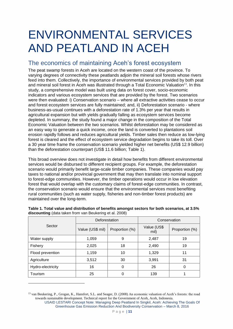
ENVIRONMENTAL SERVICES AND PEATLAND IN ACEH The economics of maintaining Aceh’s forest ecosystem The peat swamp forests in Aceh are located on the western coast of the province. To varying degrees of connectivity these peatlands adjoin the mineral soil forests whose rivers feed into them. Collectively, the importance of environmental services provided by both peat and mineral soil forest in Aceh was illustrated through a Total Economic Valuation13. In this
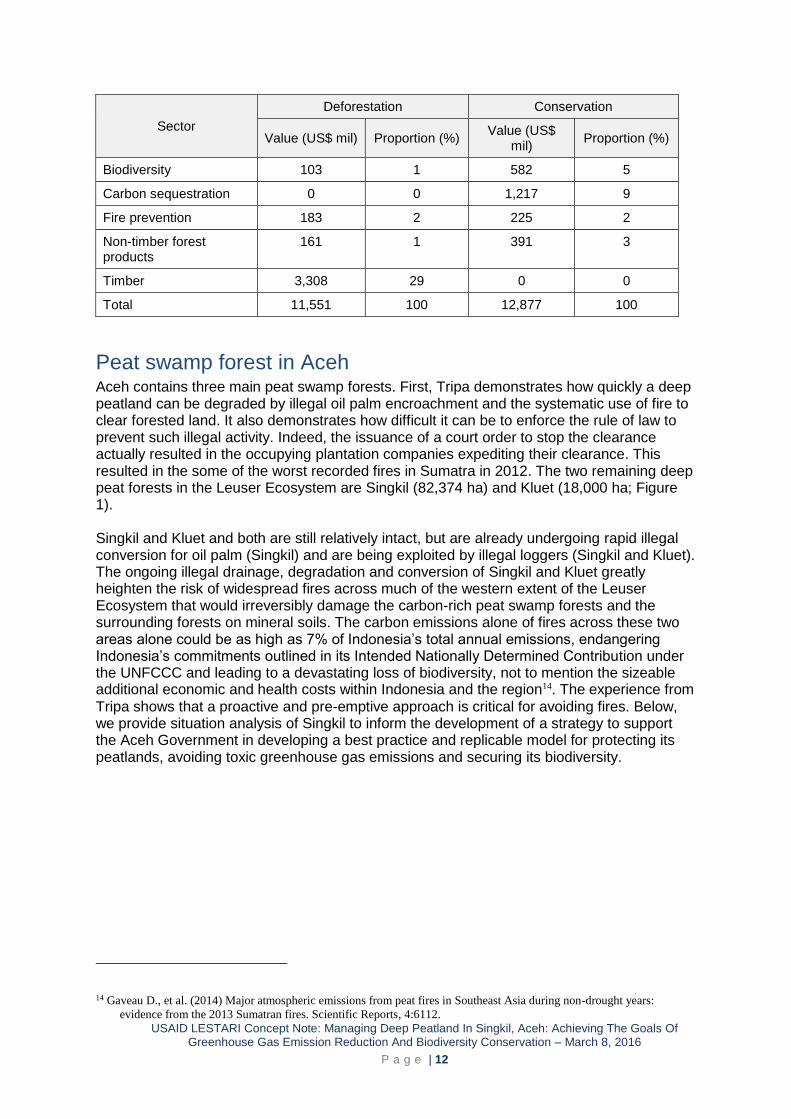
study, a comprehensive model was built using data on forest cover, socio-economic indicators and various ecosystem services that are provided by the forest. Two scenarios were then evaluated: i) Conservation scenario – where all extractive activities cease to occur and forest ecosystem services are fully maintained; and, ii) Deforestation scenario - where business-as-usual continues with a deforestation rate of 1.3% per year that results in agricultural expansion but with yields gradually falling as ecosystem services become depleted. In summary, the study found a major change in the composition of the Total Economic Valuation between the two scenarios. Whilst deforestation may be considered as an easy way to generate a quick income, once the land is converted to plantations soil erosion rapidly follows and reduces agricultural yields. Timber sales then reduce as low-lying forest is cleared and the effect of ecosystem service degradation begins to take its toll. Over a 30 year time frame the conservation scenario yielded higher net benefits (US$ 12.9 billion) than the deforestation counterpart (US$ 11.6 billion; Table 1). This broad overview does not investigate in detail how benefits from different environmental services would be disbursed to different recipient groups. For example, the deforestation scenario would primarily benefit large-scale timber companies. These companies would pay taxes to national and/or provincial government that may then translate into nominal support to forest-edge communities. However, the timber operations would occur in low elevation forest that would overlap with the customary claims of forest-edge communities. In contrast, the conservation scenario would ensure that the environmental services most benefiting rural communities (such as water supply, fisheries and non-timber forest products) are maintained over the long-term. Table 1. Total value and distribution of benefits amongst sectors for both scenarios, at 3.5% discounting (data taken from van Beukering et al. 2008)
Sector
Deforestation Conservation
Value (US$ mil) Proportion (%) Value (US$
mil) Proportion (%)
Water supply 1,059 9 2,487 19
Fishery 2,025 18 2,490 19
Flood prevention 1,159 10 1,329 11
Agriculture 3,512 30 3,991 31
Hydro-electricity 16 0 26 0
Tourism 25 0 139 1
13 van Beukering, P., Grogan, K., Hansfort, S.L. and Seager, D. (2008) An economic valuation of Aceh’s forests: the road
towards sustainable development. Technical report for the Government of Aceh, Aceh, Indonesia.
USAID LESTARI Concept Note: Managing Deep Peatland In Singkil, Aceh: Achieving The Goals Of Greenhouse Gas Emission Reduction And Biodiversity Conservation – March 8, 2016
P a g e | 12
Sector
Deforestation Conservation
Value (US$ mil) Proportion (%) Value (US$
mil) Proportion (%)
Biodiversity 103 1 582 5
Carbon sequestration 0 0 1,217 9
Fire prevention 183 2 225 2
Non-timber forest products
161 1 391 3
Timber 3,308 29 0 0
Total 11,551 100 12,877 100
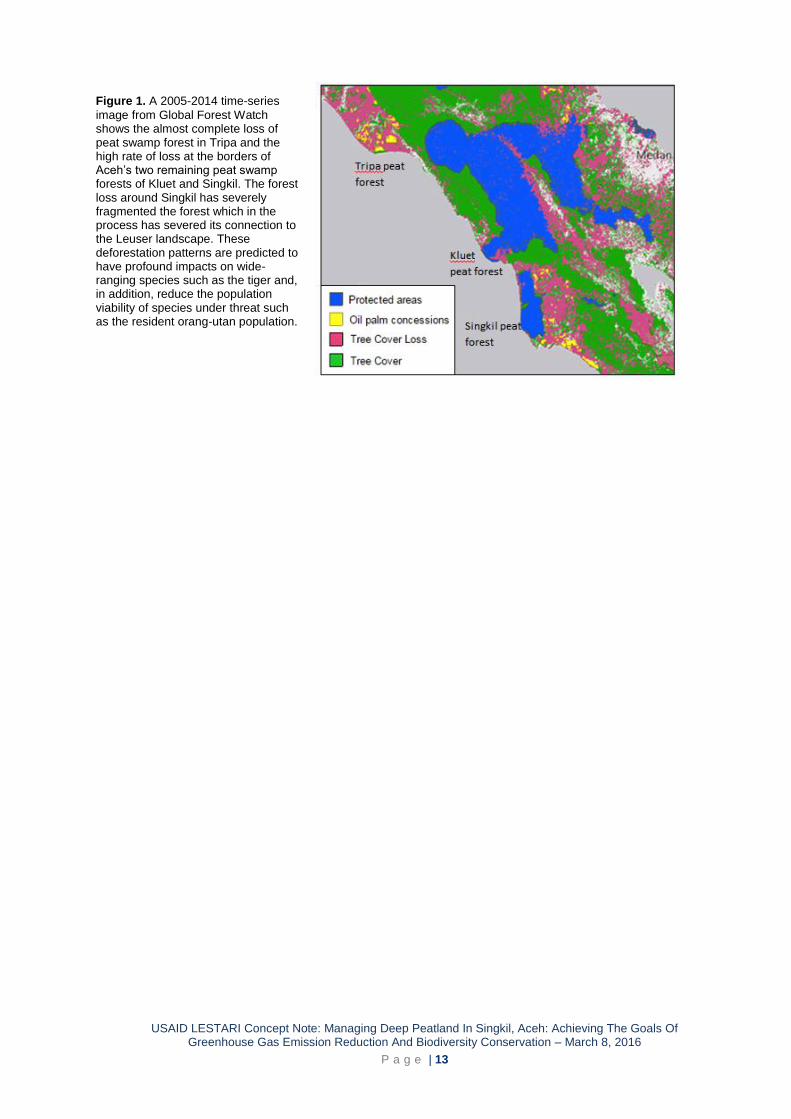
Peat swamp forest in Aceh Aceh contains three main peat swamp forests. First, Tripa demonstrates how quickly a deep peatland can be degraded by illegal oil palm encroachment and the systematic use of fire to clear forested land. It also demonstrates how difficult it can be to enforce the rule of law to prevent such illegal activity. Indeed, the issuance of a court order to stop the clearance actually resulted in the occupying plantation companies expediting their clearance. This resulted in the some of the worst recorded fires in Sumatra in 2012. The two remaining deep peat forests in the Leuser Ecosystem are Singkil (82,374 ha) and Kluet (18,000 ha; Figure 1). Singkil and Kluet and both are still relatively intact, but are already undergoing rapid illegal conversion for oil palm (Singkil) and are being exploited by illegal loggers (Singkil and Kluet). The ongoing illegal drainage, degradation and conversion of Singkil and Kluet greatly heighten the risk of widespread fires across much of the western extent of the Leuser Ecosystem that would irreversibly damage the carbon-rich peat swamp forests and the surrounding forests on mineral soils. The carbon emissions alone of fires across these two areas alone could be as high as 7% of Indonesia’s total annual emissions, endangering Indonesia’s commitments outlined in its Intended Nationally Determined Contribution under the UNFCCC and leading to a devastating loss of biodiversity, not to mention the sizeable additional economic and health costs within Indonesia and the region14. The experience from
Tripa shows that a proactive and pre-emptive approach is critical for avoiding fires. Below, we provide situation analysis of Singkil to inform the development of a strategy to support the Aceh Government in developing a best practice and replicable model for protecting its peatlands, avoiding toxic greenhouse gas emissions and securing its biodiversity.
14 Gaveau D., et al. (2014) Major atmospheric emissions from peat fires in Southeast Asia during non-drought years:
evidence from the 2013 Sumatran fires. Scientific Reports, 4:6112.
USAID LESTARI Concept Note: Managing Deep Peatland In Singkil, Aceh: Achieving The Goals Of Greenhouse Gas Emission Reduction And Biodiversity Conservation – March 8, 2016
P a g e | 13
Figure 1. A 2005-2014 time-series
image from Global Forest Watch shows the almost complete loss of peat swamp forest in Tripa and the high rate of loss at the borders of Aceh’s two remaining peat swamp forests of Kluet and Singkil. The forest loss around Singkil has severely fragmented the forest which in the process has severed its connection to the Leuser landscape. These deforestation patterns are predicted to have profound impacts on wide-ranging species such as the tiger and, in addition, reduce the population viability of species under threat such as the resident orang-utan population.
USAID LESTARI Concept Note: Managing Deep Peatland In Singkil, Aceh: Achieving The Goals Of Greenhouse Gas Emission Reduction And Biodiversity Conservation – March 8, 2016
P a g e | 14
SITUATION ANALYSIS OF SINGKIL WILDLIFE RESERVE This section assesses the status of Singkil Wildlife Reserve, with a particular focus on its environmental services (for carbon sequestration and biodiversity), principle threats, management status and current conservation initiatives. The analysis is, in part, used to identify gaps and constraints in reserve management, from which to inform the development of an action framework.
Carbon sequestration value Peat depth maps produced for Singkil by Wetlands International (2004) and RePPProT (1988) estimated respective average depths of 1.2 and 1.9 m deep. However, the coarse nature of these surveys called for a more detailed site-specific study. So, in 2012, the Leuser Ecosystem Management Body (BPKEL) commissioned Deltares (a consultancy) to conduct a rapid assessment of the peat deposits in Singkil, Tripa and Kluet15. The assessment found
that the average peat depth in Singkil was 3.8 m or at least twice as deep as previously thought (Figure 2). However, several sampling points in a peat dome measuring 10 x 15 km inside Singkil recorded peat at depths exceeding 10 m. This suggests that the recent estimates remain conservative and the average Singkil peatland is deeper still, but that future field surveys are needed to comprehensively quantify this. These peat depth finding is significant because it adds further legal support to protecting the Singkil Wildlife Reserve because under Law 32/2009 the clearance of peat >3 m deep is prohibited. The Deltares study estimated that Singkil contained a peat volume of 3,584 M m3 and a peat carbon stock of 541 M t CO2.
The Deltares study uses a rapid assessment. It therefore includes a caveat that its results are highly tentative with large uncertainties associated with them because of the limited data used and time to conduct the study. The report recommended a detailed field study to collect peat thickness and elevation data to then enable enhanced modelling of peat depth across Singkil and, from this, more accurate projections of change over a period longer than 30 years.
15 Deltares (2012). Rapid assessment of peat deposits, carbon stock, CO2 emission reduction/avoidance quantities and
hydrological rehabilitation cost for three peatlands in Aceh. A technical report for Floresta and BPKEL; Deltares
project number: 1205000.

USAID LESTARI Concept Note: Managing Deep Peatland In Singkil, Aceh: Achieving The Goals Of Greenhouse Gas Emission Reduction And Biodiversity Conservation – March 8, 2016
P a g e | 15
Figure 2. Comparison of three peat depth
assessments by RePPProt, Wetlands International (WI) and Deltares (showing pink and green peat thickness contours). The rapid assessment method applied by Deltares estimated that the peat depth across most of Singkil was 2-4 metres, but that this might still represent a conservative estimate [Map copied from Deltares, 2012 report]
Biodiversity value Singkil is home to two of the Leuser Ecosystem’s four flagship mammal species - orang-utan and tiger (elephant and rhino being the other two species). The Critically Endangered Sumatran orang-utan (Pongo abelii) numbers an estimated 14,613 wild individuals, with 11,701 occurring in the Leuser Ecosystem16. Of these 1,269 individuals live in the Singkil
Wildlife Reserve. The reserve is noteworthy for containing one of the highest known orang-utan densities (1.75 individuals/km2), which is enabled by the peat swamp forest’s shorter, less frequent and less extreme periods of low food availability as compared to mineral soil forest. In contrast, peat swamp forest does not represent optimal habitat for the Critically Endangered Sumatran tiger (Panthera tigris sumatrae) because the waterlogged nature of the forest results in low on-the-ground food availability for tiger prey, such as sambar (Rusa unicolor), muntjac (Muntiacus muntjak), pig-tailed macaque (Macaca nemestrina) and wild boar (Sus scrofa). A peat swamp forest located in eastern Sumatra recorded a low tiger density (0.5 individuals/100km2)17 but given an island-wide population size of 500-600 animals, every individual is critically important for its long-term survival. Camera trapping conducted in Singkil in 2014 by the NGO Fauna & Flora International confirmed the presence of one of the world’s rarest cats, the swamp-dwelling flat-headed cat (Prionailurus planiceps). From camera trapping work conducted in peat swamp forest from elsewhere in Sumatran, Singkil is likely to be home to populations of sun bear (Helarctos malayanus), clouded leopard (Neofelis diardi), marbled cat (Pardofelis marmorata) and leopard cat (Prionailurus bengalensis).
16 Wich, S.A., Singleton,I., Nowak, M.G., Utami Atmoko, S.S., Nisam, G., Arif, S.M., Putra, R.H., Ardi, R., Fredriksson, G.,
Usher, G., Gaveau, D.L.A. and Kühl, H.S. (2016). Land-cover changes predict steep declines for the Sumatran orangutan
(Pongo abelii). Science Advances, 2:e1500789.
17 Sunarto, S., Kelly, M.J., Vaughan, M., Klenzendorf, S., Zulfahmi, Z., Maju, H. and Parakkasi K. (2013) Threatened tigers
on the equator: multi-point abundance estimates in central Sumatra. Oryx, 47:211-220.
USAID LESTARI Concept Note: Managing Deep Peatland In Singkil, Aceh: Achieving The Goals Of Greenhouse Gas Emission Reduction And Biodiversity Conservation – March 8, 2016
P a g e | 16
Singkil, and the connecting forest known as Trumon, is classified by BirdLife International as an ‘Important Bird Area’18, under the criteria for containing ‘Globally threatened species’, notably Storm Stork (Ciconia stormi), Lesser Adjutant (Leptoptilos javanicus) and White-winged Duck (Cairina scutulata)19, and ‘Biome-restricted species’.
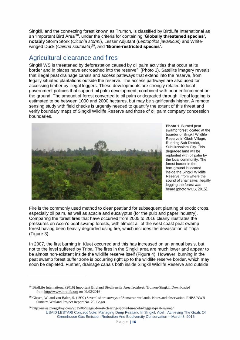
Agricultural clearance and fires Singkil WS is threatened by deforestation caused by oil palm activities that occur at its border and in places have encroached into the reserve20 (Photo 1). Satellite imagery reveals
that illegal peat drainage canals and access pathways that extend into the reserve, from legally situated plantations outside the reserve. The access pathways are also used for accessing timber by illegal loggers. These developments are strongly related to local government policies that support oil palm development, combined with poor enforcement on the ground. The amount of forest converted to oil palm or degraded through illegal logging is estimated to be between 1000 and 2000 hectares, but may be significantly higher. A remote sensing study with field checks is urgently needed to quantify the extent of this threat and verify boundary maps of Singkil Wildlife Reserve and those of oil palm company concession boundaries.
Photo 1. Burned peat
swamp forest located at the boarder of Singkil Wildlife Reserve in Oboh Village, Runding Sub District, Subulussalam City. This degraded land will be replanted with oil palm by the local community. The forest border in the background is located inside the Singkil Wildlife Reserve, from where the sound of chainsaws illegally logging the forest was
heard [photo WCS, 2015].
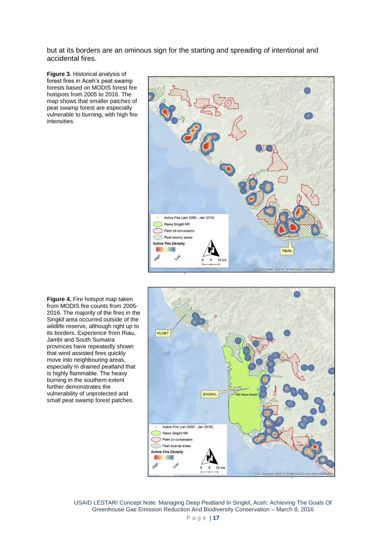
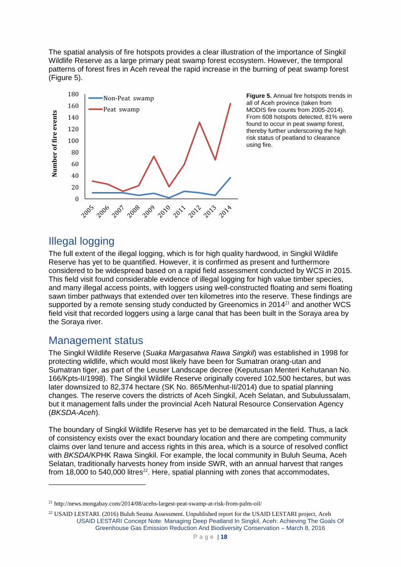
Fire is the commonly used method to clear peatland for subsequent planting of exotic crops, especially oil palm, as well as acacia and eucalyptus (for the pulp and paper industry). Comparing the forest fires that have occurred from 2005 to 2016 clearly illustrates the pressures on Aceh’s peat swamp forests, with almost all of the west coast peat swamp forest having been heavily degraded using fire, which includes the devastation of Tripa (Figure 3). In 2007, the first burning in Kluet occurred and this has increased on an annual basis, but not to the level suffered by Tripa. The fires in the Singkil area are much lower and appear to be almost non-existent inside the wildlife reserve itself (Figure 4). However, burning in the peat swamp forest buffer zone is occurring right up to the wildlife reserve border, which may soon be depleted. Further, drainage canals both inside Singkil Wildlife Reserve and outside
18 BirdLife International (2016) Important Bird and Biodiversity Area factsheet: Trumon-Singkil. Downloaded
from http://www.birdlife.org on 09/02/2016
19 Giesen, W. and van Balen, S. (1992) Several short surveys of Sumatran wetlands. Notes and observation. PHPA/AWB
Sumatra Wetland Project Report No. 26. Bogor.
20 http://news.mongabay.com/2015/06/illegal-forest-clearing-spotted-in-acehs-biggest-peat-swamp/
USAID LESTARI Concept Note: Managing Deep Peatland In Singkil, Aceh: Achieving The Goals Of Greenhouse Gas Emission Reduction And Biodiversity Conservation – March 8, 2016
P a g e | 17
but at its borders are an ominous sign for the starting and spreading of intentional and accidental fires. Figure 3. Historical analysis of
forest fires in Aceh’s peat swamp forests based on MODIS forest fire hotspots from 2005 to 2016. The map shows that smaller patches of peat swamp forest are especially vulnerable to burning, with high fire intensities.
Figure 4. Fire hotspot map taken
from MODIS fire counts from 2005-2016. The majority of the fires in the Singkil area occurred outside of the wildlife reserve, although right up to its borders. Experience from Riau, Jambi and South Sumatra provinces have repeatedly shown that wind assisted fires quickly move into neighbouring areas, especially in drained peatland that is highly flammable. The heavy burning in the southern extent further demonstrates the vulnerability of unprotected and small peat swamp forest patches.
USAID LESTARI Concept Note: Managing Deep Peatland In Singkil, Aceh: Achieving The Goals Of Greenhouse Gas Emission Reduction And Biodiversity Conservation – March 8, 2016
P a g e | 18
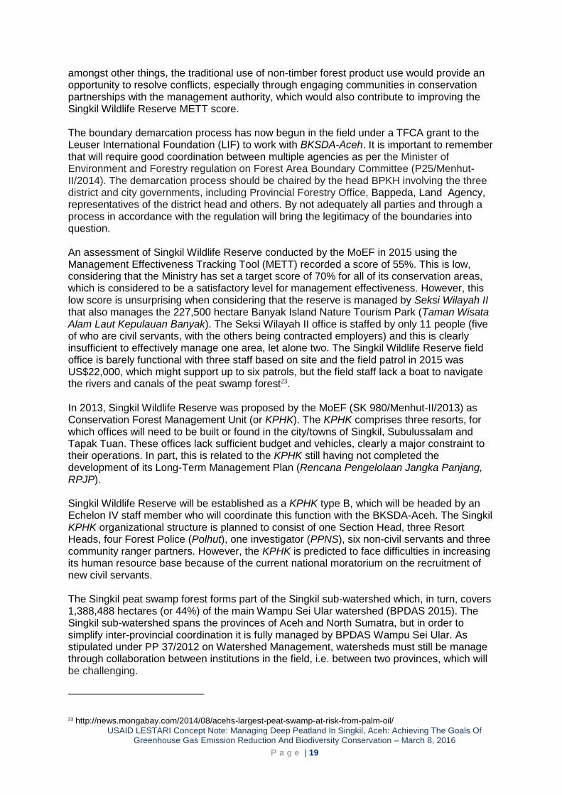
The spatial analysis of fire hotspots provides a clear illustration of the importance of Singkil Wildlife Reserve as a large primary peat swamp forest ecosystem. However, the temporal patterns of forest fires in Aceh reveal the rapid increase in the burning of peat swamp forest (Figure 5).
Figure 5. Annual fire hotspots trends in
all of Aceh province (taken from MODIS fire counts from 2005-2014). From 608 hotspots detected, 81% were found to occur in peat swamp forest, thereby further underscoring the high risk status of peatland to clearance using fire.
Illegal logging The full extent of the illegal logging, which is for high quality hardwood, in Singkil Wildlife Reserve has yet to be quantified. However, it is confirmed as present and furthermore considered to be widespread based on a rapid field assessment conducted by WCS in 2015. This field visit found considerable evidence of illegal logging for high value timber species, and many illegal access points, with loggers using well-constructed floating and semi floating sawn timber pathways that extended over ten kilometres into the reserve. These findings are supported by a remote sensing study conducted by Greenomics in 201421 and another WCS
field visit that recorded loggers using a large canal that has been built in the Soraya area by the Soraya river.
Management status The Singkil Wildlife Reserve (Suaka Margasatwa Rawa Singkil) was established in 1998 for protecting wildlife, which would most likely have been for Sumatran orang-utan and Sumatran tiger, as part of the Leuser Landscape decree (Keputusan Menteri Kehutanan No. 166/Kpts-II/1998). The Singkil Wildlife Reserve originally covered 102,500 hectares, but was later downsized to 82,374 hectare (SK No. 865/Menhut-II/2014) due to spatial planning changes. The reserve covers the districts of Aceh Singkil, Aceh Selatan, and Subulussalam, but it management falls under the provincial Aceh Natural Resource Conservation Agency (BKSDA-Aceh). The boundary of Singkil Wildlife Reserve has yet to be demarcated in the field. Thus, a lack of consistency exists over the exact boundary location and there are competing community claims over land tenure and access rights in this area, which is a source of resolved conflict with BKSDA/KPHK Rawa Singkil. For example, the local community in Buluh Seuma, Aceh Selatan, traditionally harvests honey from inside SWR, with an annual harvest that ranges from 18,000 to 540,000 litres22. Here, spatial planning with zones that accommodates,
21 http://news.mongabay.com/2014/08/acehs-largest-peat-swamp-at-risk-from-palm-oil/
22 USAID LESTARI. (2016) Buluh Seuma Assessment. Unpublished report for the USAID LESTARI project, Aceh
0
20
40
60
80
100
120
140
160
180
Nu
mb
er
of
fire
ev
en
ts
Non-Peat swamp
Peat swamp
USAID LESTARI Concept Note: Managing Deep Peatland In Singkil, Aceh: Achieving The Goals Of Greenhouse Gas Emission Reduction And Biodiversity Conservation – March 8, 2016
P a g e | 19
amongst other things, the traditional use of non-timber forest product use would provide an opportunity to resolve conflicts, especially through engaging communities in conservation partnerships with the management authority, which would also contribute to improving the Singkil Wildlife Reserve METT score. The boundary demarcation process has now begun in the field under a TFCA grant to the Leuser International Foundation (LIF) to work with BKSDA-Aceh. It is important to remember that will require good coordination between multiple agencies as per the Minister of Environment and Forestry regulation on Forest Area Boundary Committee (P25/Menhut-II/2014). The demarcation process should be chaired by the head BPKH involving the three district and city governments, including Provincial Forestry Office, Bappeda, Land Agency, representatives of the district head and others. By not adequately all parties and through a process in accordance with the regulation will bring the legitimacy of the boundaries into question. An assessment of Singkil Wildlife Reserve conducted by the MoEF in 2015 using the Management Effectiveness Tracking Tool (METT) recorded a score of 55%. This is low, considering that the Ministry has set a target score of 70% for all of its conservation areas, which is considered to be a satisfactory level for management effectiveness. However, this low score is unsurprising when considering that the reserve is managed by Seksi Wilayah II that also manages the 227,500 hectare Banyak Island Nature Tourism Park (Taman Wisata Alam Laut Kepulauan Banyak). The Seksi Wilayah II office is staffed by only 11 people (five of who are civil servants, with the others being contracted employers) and this is clearly insufficient to effectively manage one area, let alone two. The Singkil Wildlife Reserve field office is barely functional with three staff based on site and the field patrol in 2015 was US$22,000, which might support up to six patrols, but the field staff lack a boat to navigate the rivers and canals of the peat swamp forest23. In 2013, Singkil Wildlife Reserve was proposed by the MoEF (SK 980/Menhut-II/2013) as Conservation Forest Management Unit (or KPHK). The KPHK comprises three resorts, for which offices will need to be built or found in the city/towns of Singkil, Subulussalam and Tapak Tuan. These offices lack sufficient budget and vehicles, clearly a major constraint to their operations. In part, this is related to the KPHK still having not completed the development of its Long-Term Management Plan (Rencana Pengelolaan Jangka Panjang, RPJP). Singkil Wildlife Reserve will be established as a KPHK type B, which will be headed by an Echelon IV staff member who will coordinate this function with the BKSDA-Aceh. The Singkil KPHK organizational structure is planned to consist of one Section Head, three Resort Heads, four Forest Police (Polhut), one investigator (PPNS), six non-civil servants and three community ranger partners. However, the KPHK is predicted to face difficulties in increasing its human resource base because of the current national moratorium on the recruitment of new civil servants. The Singkil peat swamp forest forms part of the Singkil sub-watershed which, in turn, covers 1,388,488 hectares (or 44%) of the main Wampu Sei Ular watershed (BPDAS 2015). The Singkil sub-watershed spans the provinces of Aceh and North Sumatra, but in order to simplify inter-provincial coordination it is fully managed by BPDAS Wampu Sei Ular. As stipulated under PP 37/2012 on Watershed Management, watersheds must still be manage through collaboration between institutions in the field, i.e. between two provinces, which will be challenging.
23 http://news.mongabay.com/2014/08/acehs-largest-peat-swamp-at-risk-from-palm-oil/
USAID LESTARI Concept Note: Managing Deep Peatland In Singkil, Aceh: Achieving The Goals Of Greenhouse Gas Emission Reduction And Biodiversity Conservation – March 8, 2016
P a g e | 20
The Singkil Wildlife Reserve is located in Aceh Singkil district (2185 km2) which has a population density of 110,706 people and density of 50.7 people/km2 (BPS, 2014). It is surrounded by Aceh Selatan District (3,841 km2; 210,071 people, 54.7 people/km2) and the city of Subulussalam (1,206 km2; 72,103 people; 59.8 people/km2). Finally, based on a proposed spatial plan by the Aceh Selatan government, an area in the northern of Singkil will be allocated for a transmigration settlement. Here, forest clearance has begun and the connectivity between Singkil and GLNP via the forested Trumon Corridor is being eroded. The spatial plan indicates that energy infrastructure (a high voltage power line) may be built through Singkil Wildlife Reserve, which will require improved access roads/paths and is likely to facilitate further deforestation.
National and subnational initiatives The local NGO Leuser Indonesia Foundation (LIF) with support from a TFCA-Sumatra placing boundary markers along the Singkil Wildlife Reserve’s 233 kilometre long border and the 2 kilometre long Trumon Corridor, which is now split by an asphalt road. However, for various reasons this is being conducted without the full participation of BKSDA, as the management authority, which raises the issue of whether the boundary markers will be recognised by the various government stakeholders. The accuracy of the boundary marker placement requires verification. Next, an ongoing effort that has relevance to protecting both Kluet and Singkil from encroachment by large agribusinesses is the ongoing prosecution by the Ministry of Forestry and Environment of the five biggest firms involved in Tripa’s illegal clearance. The first and unprecedented result secured was by the Indonesian Supreme Court ordered PT Kalistra Alam to pay Rp366 billion (approximately $28 million) in fines and reparations for the damage it causes to the Tripa peat swamp forest. Efforts to reverse the damage caused to Tripa include the Aceh Forestry Agency establishing a protected zone in PT Kalistra Alam’s former concession, the damming of 18 canals that the company had constructed to drain the peat and the planting of over 100,000 trees. Related to this, the Forest, Nature and Environment of Aceh (HAkA) is providing advice and support to community groups mobilized under the ‘People’s Movement to Contest the Aceh Spatial Plan’ have filed a lawsuit against the national government. The lawsuit challenges the legality of the zonation laws passed by the Aceh parliament at the end of 2013.
International support There are several noteworthy internationally-funded projects operating in the target landscape. They each offer a complementary approach through support to,
Developing Forest Management Units (KPH) and forest restoration in southern Aceh (GFA-KfW – German Development Bank, 2013-2019, Euro8.5 million)
Improving land use governance, building multi-stakeholder constituencies and strengthening law enforcement actions (USAID-LESTARI, August 2015 to July 2020, US$5-10million allocated the for Leuser Landscape only)
Supporting spatial planning (including One Map), conducting road impact analysis and developing a provincial project management unit for environment issues (European Union, 2015-2018, Euro2-4million)
Building law enforcement agency capacity to effectively protect wildlife and forest habitat (WCS, 2007-ongoing, $300,000/yr)
Analysis of the opportunities for Water-Energy-Food nexus thinking to support sustainable development approaches in Aceh, and support to developing a conservation constituency in the Aceh parliament (Climate and Development Knowledge Network-WCS, April 2015 to December 2016, £78,953).
USAID LESTARI Concept Note: Managing Deep Peatland In Singkil, Aceh: Achieving The Goals Of Greenhouse Gas Emission Reduction And Biodiversity Conservation – March 8, 2016
P a g e | 21
OBJECTIVES AND ACTIONS From the Situation Analysis, several key gaps that undermine efforts to safeguard Singkil Wildlife Reserve and Aceh’s other peat swamp forests, notably the low management capacity of BKSDA, lack of actionable information on illegal oil palm and timber supply chains, lack of transparency on the status of existing concessions and poor knowledge of district government on land use planning policies and laws. Thus, to address this, a multi-layered approach is proposed. The project design takes a landscape approach that prioritises actions for Singkil Wildlife Reserve and its buffer zone because of its imminent high threats, but these actions are designed to be transferrable to also enable the protection of Kluet. This combined approach will showcase Singkil Wildlife Reserve as a best practice KPHK site and a successful pilot site for peat swamp forest protection.
Objective 1. Increase management effectiveness of Singkil Wildlife Reserve to protected peat forest and wildlife [Much of the funding for the activities under this objective are provided by USAID-LESTARI and WCS; GFA-KfW may cover KPHK activities]
Action 1.1. Facilitate the finalisation of the long-term management plan for the KPHK Singkil Wildlife Reserve: Expert support will be provided to the BKSDA Technical Implementation Unit to develop high-quality 10-year management plan that underpins a comprehensive approach that is elaborated through successive annual work plans. This will clearly describe the roles and responsibilities of the Unit and its partners. It will also include a rapid action plan to block the illegal canal network that has been opened up in the reserve, which through its drainage properties may be threating the viability of the peat ecosystem.
Action 1.2. Build the management capacity of the KPHK staff: Capacity building on technical and intuitional issues will be provided through training, such as on forest resources inventory and strategic planning, and site exchange visits to well-managed Forest Management Units (conservation, production and environment types).
Action 1.3. Singkil Wildlife Reserve border demarcation and spatial planning: Support for the demarcation of the reserve border is ongoing but will require support. Here, efforts will be placed on aligning the reserve border with district and provincial spatial plans, with emphasis placed on supporting the One Map initiative. It is also important to resolve community land and resource use claims through zonation inside Singkil Wildlife Reserve and through complementary buffer zone management outside of the reserve. A sub-action here could include supporting a community-based fire monitoring system and incentivising communities to maintain fire-free villages.
Action 1.4. Develop and implement a SMART-based forest ranger patrol system: For effective site level protection an adaptive management system is required. A SMART patrol system data model will be built for the reserve. Two full-time SMART patrol teams will be trained, equipped and their field operations supported. Ranger teams will consist of PNS Polhut and community members. Their patrols will be strategically conducted based on the changing spatial patterns of threats, which should enable an ever increasing number of illegal loggers and poachers to be apprehended. The ranger teams will also be responsible for implementing the canal blocking action plan, as well as collecting GPS locations on illegal logging trials and farmland/plantation encroachment inside the reserve. These data will be provided to the WCU (Action 1.4).
Action 1.5. Wildlife Crime Unit (WCU): A local informant-based network will be operated by the WCU around the reserve to determine the key actors involved in illegal logging and wildlife poaching/trade. Strong partnerships will be built with the law enforcement
USAID LESTARI Concept Note: Managing Deep Peatland In Singkil, Aceh: Achieving The Goals Of Greenhouse Gas Emission Reduction And Biodiversity Conservation – March 8, 2016
P a g e | 22
agencies, including BKSDA and the police, to support the arrest of major dealers and traders that are driving the demand for the forest and its products from the reserve.
Action 1.6. Wildlife Response Unit (WRU): To support forest-edge communities and plantation companies that are experiencing problems with wildlife, such as tiger attacks on livestock or people and orang-utans crop-raiding, WCS will support a WRU to rapidly respond with appropriate mitigation support.
Action 1.7. Orang-utan and tiger monitoring: A combination of nest-based surveys and camera-trapping will be conducted to generate robust baseline estimates for orang-utans and tigers, respectively. Repeat surveys will be conducted to monitor species-specific population trends and to evaluate efforts to reduce poaching.
Objective 2. Assess and monitor the ecosystem service benefits provided by Singkil Wildlife Reserve Action 2.1. Partner with the Indonesian Peat Restoration Agency: In order to make
Singkil (and also Kluet) a national priority and ensure that its management body is actively collaborating in national initiatives, the project will hold routine meetings with the Peat Restoration Agency to explain the importance of Singkil through disseminating key project findings, present the project approach as a replicable best practice model and identify new opportunities. Here, the project will initiate discussions on developing Singkil as a REDD+ site as part of a sustainable financing component that would be fully developed based on these discussions.
Action 2.2. Forest cover assessment and monitoring: A combination of high resolution satellite imagery and unmanned aerial vehicles (conservation drones) will be used to conduct high frequency monitoring of forest cover change, canals and artificial walkways in and around the reserve. This threat identification will be used to guide forest ranger patrols (#1.3) and evaluate their impact in reducing illegal conversion. The satellite imagery would also be used to conduct an historical analysis of forest loss, degradation and fragmentation that would be used to identify the driver of these land change patterns, from which future patterns of loss would be predicted and mapped. These data would also be used to determine historical emission levels and potential emissions that can be avoided (#2.3).
Action 2.3. Measure carbon stocks and calculate achievable GHG emissions reduction through protecting Singkil: Previous peat volume studies from Singkil have been based on coarse data or rapid assessments and conclude that more detailed studies are needed. A peat thickness map will be constructed using a digital elevation model and LiDAR data. Field surveys will bore holes to take samples to assist in measuring peat deposits and depths in more detail from which peat volume will be calculated and then volume of carbon stocks. These data will then be used to estimate the economic benefits of land-use options and opportunity costs of avoiding emissions, including proactive and reactive approaches as part of a cost-benefit analysis.
Action 2.4. Assess peatland condition: The estimated size and extent of drainage canal impacts, especially from oil palm companies bordering Singkil Wildlife Reserve, and an assessment of the extent of hydrological connectivity between the project area and surrounding peatland areas will be measured through field surveys and hydrological modelling techniques. Scenarios projecting the impact of drainage, flooding and land subsidence will be made over 25, 50 and 100 year intervals.
Action 2.5. Facilitate postgraduate research projects on environmental and socio-economic aspects of peat swamp forest: CIFOR is managing a large grant from USAID to support Indonesian students to undertake postgraduate studies on peatland at US universities. WCS has strong links with various US universities, such as Harvard School of Public Health (Harvard University and in 2016 will run a workshop with CIFOR on the
USAID LESTARI Concept Note: Managing Deep Peatland In Singkil, Aceh: Achieving The Goals Of Greenhouse Gas Emission Reduction And Biodiversity Conservation – March 8, 2016
P a g e | 23
application of landscape approaches in its field sites in Sumatra and Sulawesi. Thus, WCS, CIFOR and partners would support several research projects in Singkil, which might focus on investigating: estimates of carbon benefits; leakage types and an assessment of risks with accompanying mitigation strategies; evaluation of the site against carbon standards (such as VCS) and their methodologies; financial feasibility; and, land tenure issues.
Action 2.6. Develop project communication pieces: A key part of the project will be to widely disseminate research findings on the importance of Singkil from environmental, social and economic perspectives in easy to understand messages. A variety of techniques will be used, such as stakeholder meetings/workshops, academic papers, infographics, media articles, social media discussions groups.
Objective 3. Investigate illegal supply chains for palm oil and timber in forest and peatland areas in Aceh Selatan, Subulussulam, and Singkil which present a high future fire risk to Aceh’s forests and biodiversity. Action 3.1. Conduct a detailed palm oil supply chain assessment: Reports from
Rainforest Action Network (RAN) have made initial links between some of the palm oil plantations operating within the Leuser Ecosystem with major Indonesian Palm Oil Pledge (IPOP) companies – Wilmar, Musim Mas, and Golden Agri Resources24. The entire supply chain in the high risk areas of Singkil and Kluet will be investigated. This will focus on monitoring the smallholders and mid-sized businesses operating and/or supplying mills around the Leuser Ecosystem with illegally grown oil palm fruit, even as efforts are made by IPOP companies to improve their supply chain traceability. Building on the RAN data, WCS will conduct a detailed supply chain assessment for palm oil leading from smallholder plantations surrounding Singkil and Kluet peat swamps in order to strengthen connections between illegal forest conversion and peatland drainage with major international buyers and traders, and to uncover land owners who are in breach of Indonesian law.
Action 3.2. Conduct a detailed timber supply chain assessment: Illegal timber supply chains in the study areas will be investigated. These likely to be connected with national and international companies and investors with existing zero deforestation commitments. WCS field teams, will conduct a full investigation of the impacts of the illegal logging supply chains, and work with companies that are implicated to ensure that they commit to immediately halting all timber products from these sources.
Action 3.3. Support companies with concessions located outside of Singkil and Kluet to reduce negative impacts on the reserves: Recommendation will be made with the companies and incorporated into business management plans. The project will select and guide concession partners to implement conservation action to support Singkil and Kleut, such as by blocking canals and forest fire management collaboration amongst concessions.
Action 3.4. Compile and disseminate a Singkil Wildlife Reserve profile setting out its legal status: It is crucial to heed the lessons learned from the destruction of the Tripa peat swamp forest but also the subsequent legal action taken to prosecute PT Kalista Alam, and ongoing prosecutions of other companies, for illegally burning forest. This resulted in an unprecedented fine of US$25.6 million, and cases against five other companies being
24 RAN (2015) The Last Place on Earth.
[https://d3n8a8pro7vhmx.cloudfront.net/rainforestactionnetwork/pages/2729/attachments/original/1447180363/Last_Pl
ace_2015.pdf?1447180363]
USAID LESTARI Concept Note: Managing Deep Peatland In Singkil, Aceh: Achieving The Goals Of Greenhouse Gas Emission Reduction And Biodiversity Conservation – March 8, 2016
P a g e | 24
processed for Tripa. As a preventative action to safeguard both Singkil and Kluet, the types of documents and supporting evidence used to present the compelling legal case for Tripa will be separately compiled and summarised for these two peatlands as part of a legal review. The results will be widely disseminated, with a particular focus on discussing the results with district and provincial government. This is intended to act as a timely reminder on the correct issuance of land use permits, especially those for oil palm development, and initiate actions for those concessions that contravene Indonesian law.
Action 3.5. Supporting prosecutions and leveraging supply chain change: Where illegal activities are uncovered in Kluet and Singkil, WCS will support criminal investigations by BKSDA Aceh and Gunung Leuser National Park of the key actors in these illegal supply chains to ultimately seek their arrest and prosecution. For companies identified in the supply chain operations operating legally, but at high risk of sourcing products that are driving deforestation in the Leuser Ecosystem, WCS will seek to leverage behavioural change in the parent companies to halt sourcing from these at risk suppliers. WCS will also disseminate results to other NGO groups to capitalise on the pertinent findings from other Actions. The WCU works closely with judges and prosecutors and has its own lawyer to advise on prosecutions and monitor the court cases to ensure that the law is fairly and consistently applied. For example, it will support investigations and subsequent actions towards companies illegal burning inside the peat swamp forest.
Objective 4. Assess the financial incentives which currently drive forest clearance on peatlands in Aceh, at district, provincial and national levels, to build a business case for sustainable land use. Action 4.1. Analyse the local tax mechanisms and interactions: Working alongside the
Ministry of Finance and Ministry of Home Affairs, WCS will investigate how the local tax and revenue structure at district levels provide perverse incentives to district governments in Aceh to burn and clear forest and peatlands, and will recommend amendments that will significantly reduce the risk of fires in peatland and mineral soil areas around the Leuser Ecosystem. In particular, the district government's share of: i) land and building tax; ii) land and building transfer fee; iii) the forest license fee; iv) forest resource rent; and, v) reforestation levy may contribute towards the creation of perverse incentives which encourage burning. Here, an opportunity would be explored to work with the World Bank project on fire impact assessment from the recent haze event.
Action 4.2. Develop a clear set of recommendations to remove financial incentives for illegal clearance: This action will build on existing Indonesian legal precedent at national, provincial and district levels and will draw on lessons learned from other forested countries which have succeeded in using local tax laws to make significant changes in reducing deforestation (e.g. Costa Rica, Brazil). The action will produce practical recommendations for legal and regulatory amendments which remove existing perverse incentives or loopholes, and will explore private sector tools for leveraging sustainable business practices in high fire risk landscapes (e.g. preferential access to credit).
Action 4.3. Develop a business investment risk map: Building on the supply chain analysis under Objective 3, WCS will work with the major Indonesian and international banks and investors to develop an evidence-based investment risk map for the Singkil Wildlife Reserve and wider Leuser landscape. Investors that are identified and implicated through this work will be contacted and shown the impact of their investments on the ground.
USAID LESTARI Concept Note: Managing Deep Peatland In Singkil, Aceh: Achieving The Goals Of Greenhouse Gas Emission Reduction And Biodiversity Conservation – March 8, 2016
P a g e | 25
CONCLUSION The importance of Singkil Wildlife Reserve as a national conservation priority is manifested in the multitude of ecosystem services that the peat swamp forest provides. For example: i) for biodiversity Singkil is home to a globally important population of orang-utans; ii) for carbon sequestration Singkil is a deep peatland with an average thickness of 3.8m; and, iii) for rural livelihoods, the many rivers and estuaries provide an important source of protein through its fish stocks. In order to preserve Singkil and its ecosystem services, a range of actions involving government partners at all levels is required. Nationally, it is important to engage with the new Peat Restoration Agency to elevate the priority status of Singkil. The supporting national government actions required for Singkil and other peat swamp forests include: producing a detailed national peatland map; detailed concession maps for high risk districts and sub-districts; improved technical guidance for peatland governance and ecosystem restoration; and, strengthened community-based fire monitoring systems. To succeed on-the-ground, these efforts must be complemented through subnational actions that involve mainstay approaches, such as effective conservation and protected area management, which are coupled with community-based incentive schemes, such as rewarding fire free villages and, especially for Singkil, preventing encroachment into the reserve boundaries.

LESTARI
Wisma GKBI, 12th Floor, #1210 Jl. Jend. Sudirman No. 28, Jakarta 10210, Indonesia.
Phone: +62-21 574 0565 Fax: +62-21 574 0566
Email: [email protected]