constellation design considerations for smallsats
TRANSCRIPT
Turner 1 29th Annual AIAA/USU Conference on Small Satellites
SSC16-P4-18
Constellation Design Considerations for Smallsats
Andrew E. Turner SSL
3825 Fabian Way, Palo Alto, CA 94303, MS G54; 650/852-4071 [email protected]
ABSTRACT
Design, implementation and operation of constellations using Smallsats are discussed. Due to the modest budgets allocated for these small spacecraft, economic considerations are paramount and optimal results must be obtained with a minimum number of spacecraft. Favorable orbits, preferably low Earth orbits (LEO) with minimum inclination, reduce launch cost and optimize Earth observation and communications, however mission requirements and/or rideshare opportunities may involve higher altitude and/or inclination. Candidate orbits including circular LEO with equatorial near-zero inclination, moderate inclination, polar and sun-synchronous inclinations are considered. The focus is on 600 km altitude since this lies within the regime currently used by Smallsats. High-altitude orbits including highly elliptical cases such as geosynchronous transfer orbit (GTO), circular geosynchronous (GEO) and the super-synchronous graveyard orbit are also covered since these can be reached using rideshares on commercial GEO spacecraft. Various types of constellations including single-plane, Walker Pattern, Streets of Coverage, Rosette and hybrids are discussed. Coverage of selected geographical regions, zones and the entire Earth is presented. Means to return data from LEO spacecraft using a modest number of low-cost ground platforms are discussed. A simplified launcher performance model is used to assess relative payload performance
for various candidate orbits.
CONSTELLATION DESIGN OBJECTIVES
Earth coverage is the objective in most cases and is the focus here. Some constellations must cover the entire planet at least part of the time while others must cover the entire planet at all times, i.e. continuous global coverage. Constellations that need to only cover a portion of the surface of Earth typically provide zonal coverage, meaning that a particular zone or zones of latitude are covered, such as the North Temperate Zone, which is where most of the major business regions lie. In the case of non-continuous coverage, sometimes referred to as sparse coverage, the interval between observations or revisit time is of concern. The local solar time or time of day during which coverage is obtained is also a design point for constellations with sparse coverage. Minimum elevation for coverage is an important factor, for the detailed constellation coverage studies in this paper a value of 10˚ is assumed which
keeps the number of spacecraft reasonable.
Definition of a constellation
A constellation is a spacecraft fleet in which each member is in an orbit with the same altitude, or the same range of altitudes if the orbits are elliptical, and the same inclination. Each spacecraft in the constellation observes Earth to have the same apparent width and features on its surface to have the same apparent size. Every spacecraft in the constellation overflies the same range of latitude and therefore has a
similar ground track on its surface, follows a similar path through the sky or “skytrack” as observed from the ground. The various spacecraft experience similar sun angles with respect to its body unless sun-synchronous orbits are employed. The units in the fleet are distributed nearly uniformly through space and at any given time they lie over points distributed all around the world. Consequently the spacecraft tend to be interchangeable and are effectively “sister ships” in this
fleet.
If the spacecraft fly in a formation, sometimes referred to as a swarm, e.g. in cases studied under Project F6 funded by DARPA1, then of course they are not uniformly distributed around Earth. Altitude and inclination need not be the same for these spacecraft and tend to be biased to permit relative motion of the various units within the swarm. Swarms are not usually considered constellations and will not be discussed
further in this paper.
Global coverage
This involves an inclined orbit so that all latitudes from the North Pole to the South Pole can be covered. The orbit need not be polar (90˚ inclination) since the spacecraft can view the pole to the side even if it never appears directly beneath. The higher the altitude the more the inclination of the orbit can differ from 90˚ while the orbit still provides polar viewing. In this paper cases are discussed in which continuous viewing
Turner 2 29th Annual AIAA/USU Conference on Small Satellites
of the poles is provided for a minimum elevation of 10˚ by a 600-km altitude constellation whose orbits are at 79˚ inclination. Intermittent polar viewing from a sparse coverage constellation with orbits at the same
altitude but with inclination of 77˚ is also discussed.
Zonal coverage
In this case coverage is provided in certain zones of latitude. This coverage can be said to be “worldwide” without being global since it extends through 360˚ in longitude. The covered area is symmetrical in latitude if circular orbits are used and generally is either a single zone centered on the equator or two zones of equal size
that are separated from the equator by equal distances.
Equatorial coverage can be simpler to arrange than coverage in the North Temperate Zone but tends to serve only a limited market since most business areas such as the Contiguous United States (CONUS), Europe and East Asia lie well north of the equator. Zonal coverage may be required to be continuously available or with a revisit time of specified duration if
sparse coverage is all that is required.
Constellations used to provide zonal coverage as well as those that provide continuous coverage require multiple orbital planes. This favors the use of on-orbit spares to maintain coverage and optimize re-launch schedule. Minimizing the number of orbital planes reduces the number of spares because while it is relatively easy to reposition spacecraft within an orbital plane, transferring a spacecraft from one plane to another is very difficult. A strategy to provide “roving spares” for multi-plane constellations is discussed later.
Regional coverage
This type of coverage, which serves a specified domain of longitude and a specified range of latitude, can be provided continuously by a single spacecraft in geosynchronous orbit (GEO). However, multiple spacecraft in low Earth orbit (LEO) are required due to the relatively small fraction of Earth’s surface which each spacecraft can view at any given time, on the order of 1% instead of the nearly 42% visible from a single GEO spacecraft. Any LEO regional coverage constellation must cover all longitudes in the zone of latitude occupied by the target region to allow for Earth rotation relative to the orbital planes. Therefore, this system is effectively zonal, with the zone specified by
the latitude range of the region.
Constant time of day coverage
This requires the use of a sun-synchronous orbit and is of major concern when coverage is sparse because the lighting conditions for imaging or the time of day for
telecommunications may be important. On the other hand, in a continuous coverage case it may be desired that a particular spacecraft or group of spacecraft within a single orbital plane provides the coverage at a specific time of day. This can enable the number of spacecraft providing service at a specified time of day, e.g. peak business hours or when the sun is in a particular orientation, to be maximized by placing more spacecraft in this plane than the other planes. It also permits spacecraft design to be simplified since the portions of the spacecraft illuminated by the sun, in particular the solar arrays and radiators, can be
optimized for this fixed sun geometry.
Non-Earth coverage missions
For spacecraft studying space radiation, performing astronomy missions, or flight testing new equipment, the primary consideration relative to Earth is when data can be downlinked, as opposed to covering a specific geographic region. Other considerations include the relative orientation of the sun for power generation, for preventing excessive solar illumination of radiators for dumping waste heat, also for solar illumination of
targets to be observed if visible light sensors are used.
The use of high altitude orbits may be dictated by the environment to be observed. These tend to make the duration of contacts with stations on the surface of Earth of advantageously long duration, particularly if the spacecraft can be placed in GEO or near-GEO orbits. Experimental missions may benefit from long-duration downlink capability as well the ability to make
adjustments on ground command in real time.
Spacecraft in LEO have been used in the past for experimental missions due to limited launch vehicle (LV) payload capability. However, GEO missions for these spacecraft can be considered due to the capability of the many commercial large GEO spacecraft to carry rideshare craft that are separated in or near GEO. For LEO missions the use of an equatorial orbit may be advantageous due to the larger LV payload capability in
this case, even though the zone covered is narrow.
ORBIT TYPES
Low Earth Orbit (LEO)
This typically involves altitudes from 200 km up to 2000 km and high inclination including polar and sun-synchronous trajectories. These are the easiest orbits to reach from the surface of Earth, especially orbits whose inclination equals the latitude of the launch site, e.g. 28.5˚ inclination for a Cape Canaveral launch. U.S. Government regulations require all craft in this altitude regime to be de-orbited into the atmosphere of Earth with 25 years of service termination2. Therefore, a
Turner 3 29th Annual AIAA/USU Conference on Small Satellites
spacecraft could re-enter 40 years after launch if it operated for 15 years. Atmospheric drag typically brings spacecraft into the atmosphere within this time regime if altitude is on the order of 600 km provided the spacecraft has a sufficiently large area-to-mass ratio such that drag effects are significant. Lower altitudes provide more assurance of decay within the required 25-year span. Orbits in this altitude regime are useful for Earth observation and low-latency, low-power telecommunications missions. As mentioned previously, experimental missions and astronomy missions make use of this altitude regime to maximize
launch vehicle payload capacity.
Sun-synchronous orbits
These fall into two categories, a nearly polar but retrograde (inclination greater than 90˚) LEO orbit and
an elliptical high-altitude equatorial orbit.
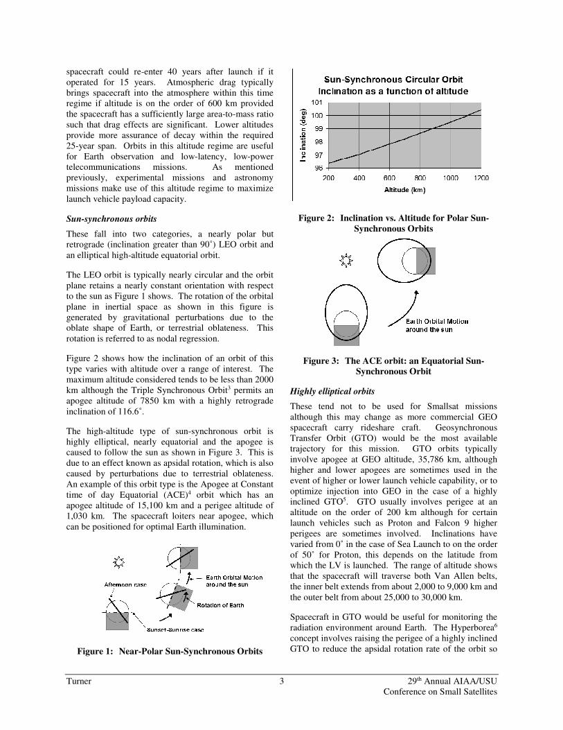
The LEO orbit is typically nearly circular and the orbit plane retains a nearly constant orientation with respect to the sun as Figure 1 shows. The rotation of the orbital plane in inertial space as shown in this figure is generated by gravitational perturbations due to the oblate shape of Earth, or terrestrial oblateness. This
rotation is referred to as nodal regression.
Figure 2 shows how the inclination of an orbit of this type varies with altitude over a range of interest. The maximum altitude considered tends to be less than 2000 km although the Triple Synchronous Orbit3 permits an apogee altitude of 7850 km with a highly retrograde
inclination of 116.6˚.
The high-altitude type of sun-synchronous orbit is highly elliptical, nearly equatorial and the apogee is caused to follow the sun as shown in Figure 3. This is due to an effect known as apsidal rotation, which is also caused by perturbations due to terrestrial oblateness. An example of this orbit type is the Apogee at Constant time of day Equatorial (ACE)4 orbit which has an apogee altitude of 15,100 km and a perigee altitude of 1,030 km. The spacecraft loiters near apogee, which
can be positioned for optimal Earth illumination.
Figure 1: Near-Polar Sun-Synchronous Orbits
Figure 2: Inclination vs. Altitude for Polar Sun-
Synchronous Orbits
Figure 3: The ACE orbit: an Equatorial Sun-
Synchronous Orbit
Highly elliptical orbits
These tend not to be used for Smallsat missions although this may change as more commercial GEO spacecraft carry rideshare craft. Geosynchronous Transfer Orbit (GTO) would be the most available trajectory for this mission. GTO orbits typically involve apogee at GEO altitude, 35,786 km, although higher and lower apogees are sometimes used in the event of higher or lower launch vehicle capability, or to optimize injection into GEO in the case of a highly inclined GTO5. GTO usually involves perigee at an altitude on the order of 200 km although for certain launch vehicles such as Proton and Falcon 9 higher perigees are sometimes involved. Inclinations have varied from 0˚ in the case of Sea Launch to on the order of 50˚ for Proton, this depends on the latitude from which the LV is launched. The range of altitude shows that the spacecraft will traverse both Van Allen belts, the inner belt extends from about 2,000 to 9,000 km and
the outer belt from about 25,000 to 30,000 km.
Spacecraft in GTO would be useful for monitoring the radiation environment around Earth. The Hyperborea6 concept involves raising the perigee of a highly inclined GTO to reduce the apsidal rotation rate of the orbit so
Turner 4 29th Annual AIAA/USU Conference on Small Satellites
its apogee remains near a desired latitude for a few months. A velocity increment (∆V) of 340 meters per second is required to shape a 12-hour period orbit of this type from a standard GTO with apogee at GEO, perigee at 200 km altitude, and a period of revolution
about 10.5 hours.
Transfer from GTO to the ACE orbit would involve a somewhat higher ∆V unless the transfer orbit inclination were low. In this case a reasonable ∆V on the order of 150 m/s would be required provided
atmospheric drag can be employed to lower apogee.
GTO is also useful as a drop-off orbit for lunar missions7 and deep space missions as well. The low perigee and high apogee permit the maneuvers to raise apogee to lunar and greater altitudes to be on the order
of 700 m/s.
End of life disposal for spacecraft is facilitated in these orbits by the low perigee altitude generally used, also perturbations of the orbit due to the gravity of the moon and to a lesser extent the sun, which can increase orbital eccentricity, thus lowering perigee into the upper atmosphere and assuring re-entry within 25 years.
Other highly elliptical orbits that have been used include Molniya and Tundra8, 9 orbits. In the future variations of these orbits such as the Three Apogee (TAP) also known as the Raindrop orbit10 may also be employed. Molniya and TAP orbits involve inclinations of about 63˚ to eliminate apsidal rotation so that apogee latitude can be maintained at an optimal value. Tundra orbits can employ a variety of inclinations including polar11 because the perturbations that generate apsidal rotation are considerably weaker at greater distances from the oblate Earth. The elliptical Triple Synchronous Orbit mentioned earlier also experiences no apsidal rotation because it has an approximately 117˚ inclination which is the supplement of the 63˚ inclination which enables the Molniya orbit. The number of commercial launches to these trajectories has been very low and therefore they will
not be discussed in detail in this paper.
To support studies of the Van Allen belts low inclination highly elliptical orbits such as GTO, Hyperborea and ACE are advantageous since the radiation levels tend to be more intense at lower latitudes, also these regions of the belt are traversed by more spacecraft, including missions to GEO, the moon,
the planets and other bodies in deep space.
High altitude orbits
GEO is very widely used, at any time there are approximately 400 spacecraft in this orbit, many of
which are involved in lucrative commercial missions. This provides considerable opportunities for rideshare missions. The obvious advantage of GEO is the continuous availability of contact with the spacecraft for imaging and communications, thus optimizing regional coverage. A disadvantage is the strict regulation of this orbit for debris mitigation, requiring the spacecraft to avoid approaching any of the many
other craft stationed there.
The Eaglet concept6 includes the means to assure collision avoidance by requiring the continuous expenditure of propellant at a modest rate by the Smallsat to maintain its position relative to a large commercial GEO spacecraft. This enables the GEO spacecraft to assist with downlinking data from and uplinking commands to the small spacecraft. The Smallsat can be more economical since its Telemetry & Commanding subsystem can be much more modest. The Smallsat could assist with the In Orbit Testing (IOT) of the large GEO spacecraft, which is an integral
part of these commercial missions.
U.S. regulations and international guidelines require the removal of any spacecraft at end of life to a graveyard orbit with perigee altitude at least 300 km higher2 than GEO. While the end of life de-orbit ∆V is only about 11 m/s and is therefore modest, this procedure does necessitate the inclusion of a propulsion subsystem and the necessary control capability to maintain spacecraft pointing while it is operated. Furthermore, the spacecraft must be sufficiently reliable to guarantee successful operation at mission termination.
An alternative is to have a commercial spacecraft which hosts one or more rideshare payloads inject itself into the super-synchronous graveyard orbit when it is en route to GEO and then separate the rideshare craft. This can enable even a very modest Smallsat with no propulsion capability to be used, and this also minimizes on-orbit reliability concerns. In the super-synchronous graveyard orbit the spacecraft can remain in view of a ground station for about a month as it slowly drifts west, enabling work to be performed with real-time control and data downlink 24 hours a day for a useful length of time even if only a single station is used.
Other high altitude orbits are not widely used. Rideshares on future lunar missions such as Lunar Flashlight12 planned as a secondary payload on the Space Launch System (SLS) may pave the way for an expansion into lunar and deep space. At present there are no commercial missions into these regions so these
classes of orbits are not discussed in detail in this paper.
Turner 5 29th Annual AIAA/USU Conference on Small Satellites
TYPES OF CONSTELLATIONS
Single Plane Constellations
In a constellation of this type all spacecraft lie within a single plane in space. While there are many historical cases in which the spacecraft are not equally distributed around the plane, analysis here will be limited to cases
where the Smallsats are uniformly distributed.
The entire “geostationary arc” lies in the equator, so the roughly 400 spacecraft in GEO, or the subsets of this total that belong to individual owner-operators, can be regarded as single plane constellations. Arthur C. Clarke13 proposed a single-plane constellation consisting of 3 equally spaced communications “rocket
stations” in GEO in 1945.
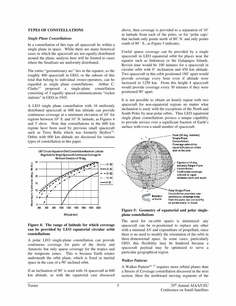
A LEO single plane constellation with 16 uniformly distributed spacecraft at 600 km altitude can provide continuous coverage at a minimum elevation of 10˚ for regions between 10˚ S. and 10˚ N. latitude, as Figures 4 and 5 show. Note that constellations in the 600 km regime have been used by previous small spacecraft such as Terra Bella which was formerly Skybox14. Orbits with 600 km altitude are discussed for various
types of constellation in this paper.
Figure 4: The range of latitude for which coverage
can be provided by LEO equatorial circular orbit
constellations
A polar LEO single-plane constellation can provide continuous coverage for parts of the Arctic and Antarctic but only sparse coverage for the tropics and the temperate zones. This is because Earth rotates underneath the orbit plane, which is fixed in inertial
space in the case of a 90˚ inclined orbit.
If an inclination of 90˚ is used with 16 spacecraft at 600 km altitude, as with the equatorial case discussed
above, then coverage is provided to a separation of 10˚ in latitude from each of the poles, or for ‘polar caps’ that include only points north of 80˚ N. and only points south of 80 ˚ S., as Figure 5 indicates.
Useful sparse coverage can be provided by a single spacecraft in LEO equatorial orbit for places near the equator such as Indonesia or the Galapagos Islands. Revisit time would be 100 minutes for a spacecraft in circular orbit with 0˚ inclination and 450 km altitude. Two spacecraft in this orbit positioned 180˚ apart would provide coverage every hour even if altitude were increased to 1250 km. From this height 4 spacecraft would provide coverage every 30 minutes if they were
positioned 90˚ apart.
It is not possible to obtain an hourly repeat with two spacecraft for non-equatorial regions no matter what inclination is used, with the exceptions of the North and South Poles by near-polar orbits. Thus LEO equatorial single plane constellations possess a unique capability to provide service over a significant fraction of Earth’s
surface with even a small number of spacecraft.
Figure 5: Geometry of equatorial and polar single-
plane constellations
The need for on-orbit spares is minimized: any spacecraft can be re-positioned to replace any other with a minimal ∆V and expenditure of propellant, since there is no need to modify the orientation of the orbit in three-dimensional space. In some cases, particularly GEO, this flexibility may be hindered because a spacecraft payload may be optimized to serve a
particular geographical region.
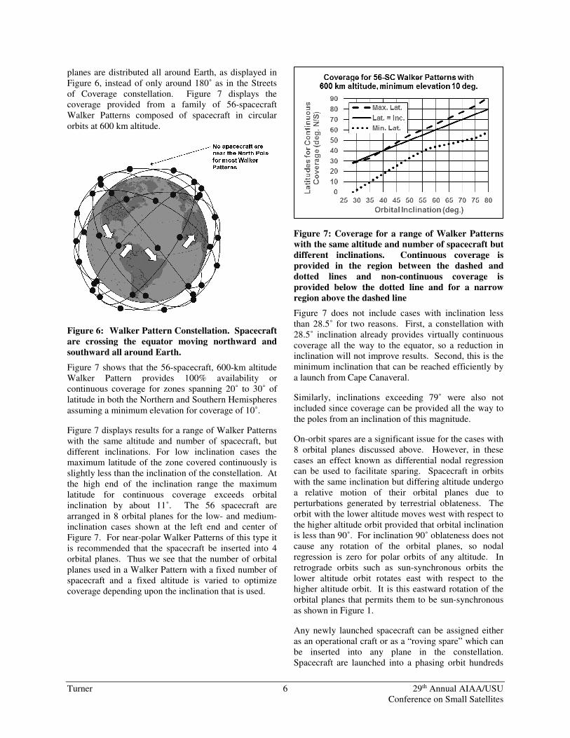
Walker Patterns
A Walker Pattern16, 17 requires more orbital planes than a Streets of Coverage constellation discussed in the next section. Here the northward moving segments of the
Turner 6 29th Annual AIAA/USU Conference on Small Satellites
planes are distributed all around Earth, as displayed in Figure 6, instead of only around 180˚ as in the Streets of Coverage constellation. Figure 7 displays the coverage provided from a family of 56-spacecraft Walker Patterns composed of spacecraft in circular
orbits at 600 km altitude.
Figure 6: Walker Pattern Constellation. Spacecraft
are crossing the equator moving northward and
southward all around Earth.
Figure 7 shows that the 56-spacecraft, 600-km altitude Walker Pattern provides 100% availability or continuous coverage for zones spanning 20˚ to 30˚ of latitude in both the Northern and Southern Hemispheres
assuming a minimum elevation for coverage of 10˚.
Figure 7 displays results for a range of Walker Patterns with the same altitude and number of spacecraft, but different inclinations. For low inclination cases the maximum latitude of the zone covered continuously is slightly less than the inclination of the constellation. At the high end of the inclination range the maximum latitude for continuous coverage exceeds orbital inclination by about 11˚. The 56 spacecraft are arranged in 8 orbital planes for the low- and medium-inclination cases shown at the left end and center of Figure 7. For near-polar Walker Patterns of this type it is recommended that the spacecraft be inserted into 4 orbital planes. Thus we see that the number of orbital planes used in a Walker Pattern with a fixed number of spacecraft and a fixed altitude is varied to optimize coverage depending upon the inclination that is used.
Figure 7: Coverage for a range of Walker Patterns
with the same altitude and number of spacecraft but
different inclinations. Continuous coverage is
provided in the region between the dashed and
dotted lines and non-continuous coverage is
provided below the dotted line and for a narrow
region above the dashed line
Figure 7 does not include cases with inclination less than 28.5˚ for two reasons. First, a constellation with 28.5˚ inclination already provides virtually continuous coverage all the way to the equator, so a reduction in inclination will not improve results. Second, this is the minimum inclination that can be reached efficiently by
a launch from Cape Canaveral.
Similarly, inclinations exceeding 79˚ were also not included since coverage can be provided all the way to
the poles from an inclination of this magnitude.
On-orbit spares are a significant issue for the cases with 8 orbital planes discussed above. However, in these cases an effect known as differential nodal regression can be used to facilitate sparing. Spacecraft in orbits with the same inclination but differing altitude undergo a relative motion of their orbital planes due to perturbations generated by terrestrial oblateness. The orbit with the lower altitude moves west with respect to the higher altitude orbit provided that orbital inclination is less than 90˚. For inclination 90˚ oblateness does not cause any rotation of the orbital planes, so nodal regression is zero for polar orbits of any altitude. In retrograde orbits such as sun-synchronous orbits the lower altitude orbit rotates east with respect to the higher altitude orbit. It is this eastward rotation of the orbital planes that permits them to be sun-synchronous
as shown in Figure 1.
Any newly launched spacecraft can be assigned either as an operational craft or as a “roving spare” which can be inserted into any plane in the constellation. Spacecraft are launched into a phasing orbit hundreds
Turner 7 29th Annual AIAA/USU Conference on Small Satellites
of kilometers below the operational altitude and undertake orbit raising maneuvers to reach their desired orbital slots. This orbit raising can be performed shortly after launch or after a delay of a month or two to enable multiple planes to be populated by spacecraft carried on a particular launcher. Alternatively, the orbit raising can be delayed for years if the spacecraft is assigned to be a roving spare. The differential nodal regression causes the phasing orbit to move relative to the operational planes at a rate on the order of 1˚ per day or one full revolution around the operational planes
in approximately 1 year18.
This section has shown that a Walker Pattern requires about 56 spacecraft for continuous worldwide coverage over a useful zone in latitude for an altitude of 600 km. The latitude of the zone can be tailored by adjusting orbital inclination. Multiple Walker Patterns or a far larger Walker Pattern could be used to provide continuous global coverage, however the number of
spacecraft involved would be in the hundreds.
A Walker Pattern was used by Globalstar18 when this 48-spacecraft, 8-plane, 1414-km altitude, 52˚-inclined constellation was inaugurated in 2000. Walker Patterns have also been used by the U.S. Global Positioning System (GPS)17 and Sirius17.
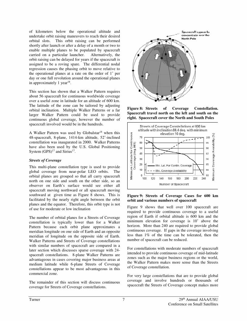
Streets of Coverage
This multi-plane constellation type is used to provide global coverage from near-polar LEO orbits. The orbital planes are grouped so that all carry spacecraft north on one side and south on the other side, so an observer on Earth’s surface would see either all spacecraft moving northward or all spacecraft moving southward at given time as Figure 8 shows. This is facilitated by the nearly right angle between the orbit planes and the equator. Therefore, this orbit type is not
of use for moderate or low inclination
The number of orbital planes for a Streets of Coverage constellation is typically lower than for a Walker Pattern because each orbit plane approximates a meridian longitude on one side of Earth and an opposite meridian of longitude on the opposite side of Earth. Walker Patterns and Streets of Coverage constellations with similar numbers of spacecraft are compared in a later section which discusses sparse coverage with 24-spaceraft constellations. 8-plane Walker Patterns are advantageous in cases covering major business areas at medium latitude while 6-plane Streets of Coverage constellations appear to be most advantageous in this
commercial zone.
The remainder of this section will discuss continuous
coverage for Streets of Coverage constellations.
Figure 8: Streets of Coverage Constellation.
Spacecraft travel north on the left and south on the
right. Spacecraft cover the North and South Poles
Figure 9: Streets of Coverage Cases for 600 km
orbit and various numbers of spacecraft
Figure 9 shows that well over 100 spacecraft are required to provide continuous coverage to a useful region of Earth if orbital altitude is 600 km and the minimum elevation for coverage is 10˚ above the horizon. More than 240 are required to provide global continuous coverage. If gaps in the coverage involving less than 1% of the time can be tolerated, then the
number of spacecraft can be reduced.
For constellations with moderate numbers of spacecraft intended to provide continuous coverage of mid-latitude zones such as the major business regions or the world, the Walker Pattern makes more sense than the Streets
of Coverage constellation.
For very large constellations that are to provide global coverage and involve hundreds or thousands of spacecraft the Streets of Coverage concept makes more
Turner 8 29th Annual AIAA/USU Conference on Small Satellites
sense than the Walker Pattern. This is because efficient use is made of near-polar orbits and the number of orbital planes tends to be lower than a Walker Pattern with a similar number of spacecraft. As discussed, smaller number of orbital planes tends to minimize the
number of on-orbit spares required.
In the future a constellation of this type may employ sun-synchronous orbits to provide a simpler environment for the spacecraft in the constellation, for example all spacecraft would experience a restricted range of sun angles and some spacecraft would experience minimal eclipse duration, enabling optimal design. It would also enable certain planes to be loaded with higher numbers of spacecraft to provide coverage
for the higher traffic at peak hours of the day.
A Streets of Coverage Constellation involving 66 spacecraft in 6 orbital planes with 86.4˚ inclination at 780 km was used by Iridium19 when it was inaugurated in the late 1990s. On the other hand Globalstar required 8 orbital planes. If on-orbit spares are to be injected into each plane for rapid replacement of failed units, then the Streets of Coverage constellation would have an advantage since it is very difficult to move
spares from one orbital plane to another.
Rosettes
A Rosette20 includes orbits with a period equal to a simple fraction of the length of the sidereal day or the time required for Earth to rotate once in inertial space, 23 hours 56 minutes 4 seconds, or a slight variation on this period to allow for nodal regression due to terrestrial oblateness. Therefore, the spacecraft completes an integer or simple mixed number of
revolutions each time Earth rotates once.
For example if the spacecraft completed 15.5 revolutions per day, it would overfly the same site on the surface of Earth every 2 days. These “every other day” overflights would occur every 31 times the
spacecraft revolved around Earth, or every 31 revs.
The ground tracks of such a spacecraft form repeating patterns which resemble flowers, particularly in orbits at high altitude. This is why Rosettes are sometimes
referred to as ‘flower constellations’21.
The 600 km altitude orbit studied for the previous constellation types has a period of revolution in inertial space (sidereal period) of 96.7 minutes, so it completes about 14.9 revs in a sidereal day. If the spacecraft is in a polar orbit with inclination 90˚, the ground track will not repeat for many days. Reducing orbital altitude to about 554 km would reduce the period to 95.7 minutes so that the spacecraft completes exactly 15.0 revs in a
sidereal day and overflies each target site on Earth’s
surface once a day.
If the inclination is less than 90˚, then the orbital period must be slightly reduced because the orbit plane rotates to the west in inertial space and the passage of the spacecraft over a specified meridian of longitude on Earth’s surface occurs in slightly less time than one
sidereal day because Earth is rotating east to meet it.
If a retrograde orbit in which inclination exceeds 90˚ is selected, then the orbit period must be increased since nodal regression operates eastward. For a near-polar sun-synchronous orbit, nodal regression matches the 1˚ per day annual apparent motion of the sun due to Earth’s orbital motion. An orbit which completes 15 revs daily in this case would have a period of 1/15th of the 24-hour solar day, or 96.0 minutes. The required altitude is 567 km. Inclination for a sun-synchronous
orbit with this altitude is 97.7˚ (Figure 2).
The Rosette constellations are useful to obtain a one-day repeat for coverage of the same spot on Earth’s surface from the same spacecraft. The hourly repeat coverage possible near the equator from a pair of spacecraft in a LEO equatorial orbit discussed earlier in the Single Plane constellation section is extended for all latitudes, but on a less frequent and less favorable schedule. We obtain a daily revisit instead of a 2-hour revisit for a single spacecraft. Another disadvantage is that Rosettes require more precise control of the orbital period and therefore more frequent maneuvers, which may disturb spacecraft pointing when imaging is being
performed.
A Streets of Coverage constellation or a Walker Pattern may be a Rosette if the period of its orbits is set to the
adjusted simple fraction of a day.
The ACE orbit and the Hyperborea orbit discussed earlier in the highly elliptical orbits section have periods of 1/5th of a day and one-half day, respectively.
These could also be classed as Rosettes.
Certain Earth observation spacecraft such as Landsat have employed repeating orbits of this type although a
daily repeat has not been used in these cases.
Hybrids
A hybrid constellation is a combination of constellations of different types and may well employ spacecraft with different designs in its segments. It could be a combination of a Single-Plane constellation
and a Walker Pattern, as will be discussed.
Turner 9 29th Annual AIAA/USU Conference on Small Satellites
A comparison of Figure 1 and Figure 6 shows that for spacecraft at 600 km altitude a 16-spacecraft single-plane constellation with 0˚ inclination and a 56-spacecraft Walker Pattern with 35˚ inclination could be used as a hybrid to provide coverage all the way from the equator to about 35˚ latitude. The single plane constellation provides all the coverage within 10˚ latitude of the equator and the Walker Pattern provides
the remainder.
Similarly a Walker Pattern with an inclination of about 72˚ could the paired with a single-plane constellation with 90˚ to provide coverage all the way from 45˚ latitude to the pole. This hybrid would enable all points in Canada and the Arctic region to her north to be
covered.
The two segments of the constellation will have spacecraft with different operating characteristics because the sun angles relative to the orbits differ considerably: in the equatorial segment the direction to the sun will remain within 23.4˚ of the orbital plane. In the inclined segment the angle between the orbit plane and the sun-direction vector will be considerably higher, reaching 90˚ if orbital inclination exceeds 66.6˚. This can result in a different solar array configuration and/or a different means of steering the spacecraft to obtain power from the sun by the spacecraft in the two
segments.
The two segments would be operated at somewhat different altitudes to avoid collisions. Collisions within a single Streets of Coverage constellation or a within a single Walker Pattern are prevented by positioning the spacecraft so they do not cross the intersection points of the planes of the constellation at the same time. Perturbations tend not to increase the collision probabilities within single constellations because all of the spacecraft in Streets of Coverage constellations and Walker Patterns are in orbits with the same inclination, thus minimizing differential effects. However, hybrids typically include segments with different inclinations, which necessitates separation in altitude, probably on
the order of 50 km.
The equatorial segment might also be operated at a considerably higher altitude such as geosynchronous orbit to take advantage of the wide range of latitude
which is covered.
Hybrids of single plane and Streets of Coverage constellations do not appear advantageous for spacecraft at 600 km altitude with minimum elevation for coverage of 10˚. In the equatorial case a Streets of Coverage constellation that provides coverage from the poles to 10˚ latitude does not have significantly fewer spacecraft than one providing coverage all the way to
the equator. A hybrid consisting of a polar single plane constellation and a Streets of Coverage constellation is not productive because the Streets of Coverage constellation provides optimal polar coverage.
A hybrid between two constellations of the same type could take the form of a single-plane constellations with both equatorial and polar planes, as Figure 5 suggests. These could be the interim phases to a larger and more capable constellation, possibly Walker Patterns, with the spacecraft and other hardware, and possibly the business model and the revenue stream demonstrated before further investment is required.
A hybrid consisting of multiple Rosettes would be of use if different sites on the surface of Earth were to be
revisited at different intervals.
A hybrid between two Streets of Coverage constellations with the same mission does not appear to make sense since the coverage regions would overlap
entirely.
Sparse coverage
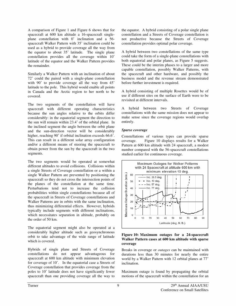
Constellations of various types can provide sparse coverage. Figure 10 displays results for a Walker Pattern at 600 km altitude with 24 spacecraft, a modest number compared with the 56-spacecraft constellations
studied earlier for continuous coverage.
Figure 10: Maximum outages for a 24-spacecraft
Walker Pattern cases at 600 km altitude with sparse
coverage
Breaks in coverage or outages can be maintained with durations less than 30 minutes for nearly the entire world by a Walker Pattern with 12 orbital planes at 77˚
inclination.
Maximum outage is found by propagating the orbital motions of the spacecraft within the constellation for an
Turner 10 29th Annual AIAA/USU Conference on Small Satellites
entire day, or rotation of Earth within the constellation, so that all points on Earth’s surface are within view of all orbital planes in the constellation. This outage is the worst-case gap in coverage at a given latitude. If a longer time span is studied, for example three days, the worst-case outage would remain the same although the total time for which no coverage is provided would
triple.
Outages can be reduced to 20 minutes or less in major business areas such as those within CONUS by a Walker Pattern with 8 orbital planes at 57˚ inclination, which lies within the allowable launch azimuth range
for Cape Canaveral.
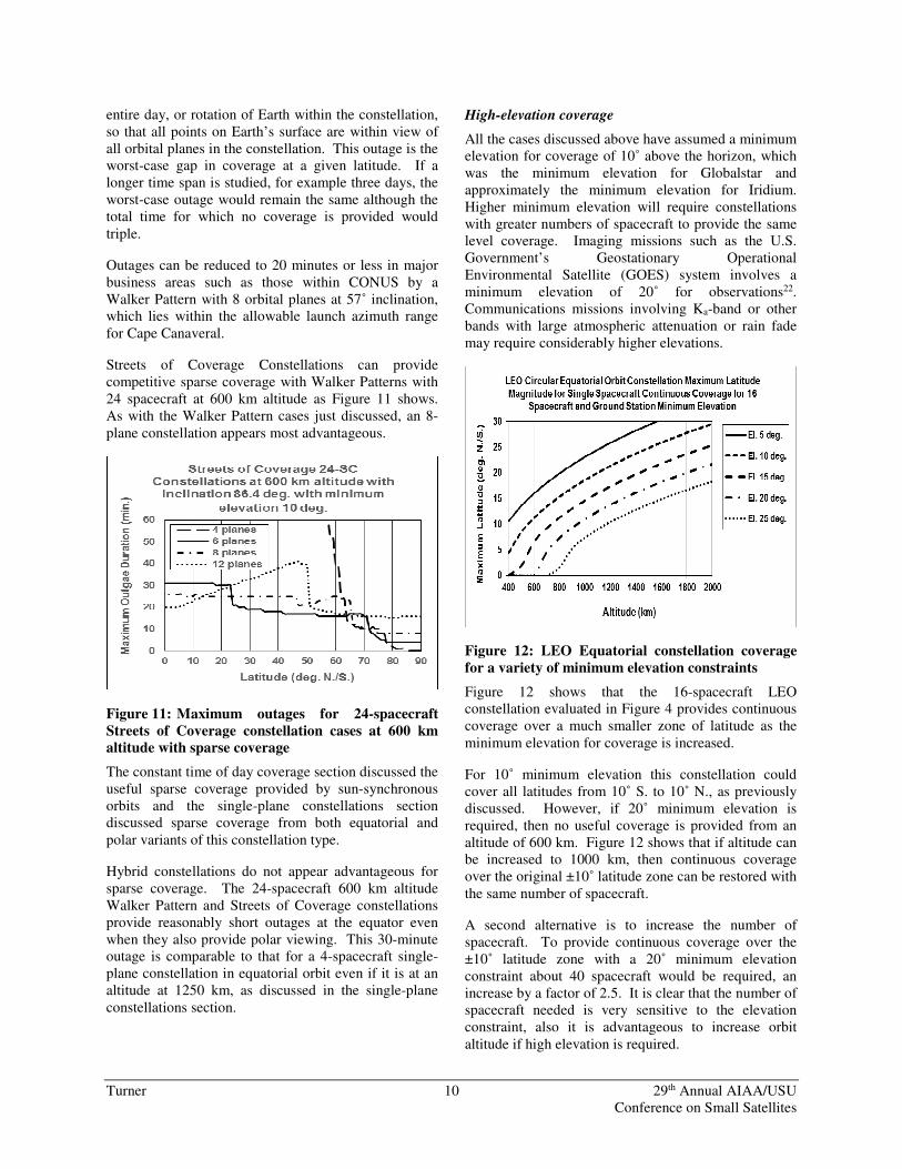
Streets of Coverage Constellations can provide competitive sparse coverage with Walker Patterns with 24 spacecraft at 600 km altitude as Figure 11 shows. As with the Walker Pattern cases just discussed, an 8-
plane constellation appears most advantageous.
Figure 11: Maximum outages for 24-spacecraft
Streets of Coverage constellation cases at 600 km
altitude with sparse coverage
The constant time of day coverage section discussed the useful sparse coverage provided by sun-synchronous orbits and the single-plane constellations section discussed sparse coverage from both equatorial and
polar variants of this constellation type.
Hybrid constellations do not appear advantageous for sparse coverage. The 24-spacecraft 600 km altitude Walker Pattern and Streets of Coverage constellations provide reasonably short outages at the equator even when they also provide polar viewing. This 30-minute outage is comparable to that for a 4-spacecraft single-plane constellation in equatorial orbit even if it is at an altitude at 1250 km, as discussed in the single-plane
constellations section.
High-elevation coverage
All the cases discussed above have assumed a minimum elevation for coverage of 10˚ above the horizon, which was the minimum elevation for Globalstar and approximately the minimum elevation for Iridium. Higher minimum elevation will require constellations with greater numbers of spacecraft to provide the same level coverage. Imaging missions such as the U.S. Government’s Geostationary Operational Environmental Satellite (GOES) system involves a minimum elevation of 20˚ for observations22. Communications missions involving Ka-band or other bands with large atmospheric attenuation or rain fade may require considerably higher elevations.
Figure 12: LEO Equatorial constellation coverage
for a variety of minimum elevation constraints
Figure 12 shows that the 16-spacecraft LEO constellation evaluated in Figure 4 provides continuous coverage over a much smaller zone of latitude as the
minimum elevation for coverage is increased.
For 10˚ minimum elevation this constellation could cover all latitudes from 10˚ S. to 10˚ N., as previously discussed. However, if 20˚ minimum elevation is required, then no useful coverage is provided from an altitude of 600 km. Figure 12 shows that if altitude can be increased to 1000 km, then continuous coverage over the original ±10˚ latitude zone can be restored with
the same number of spacecraft.
A second alternative is to increase the number of spacecraft. To provide continuous coverage over the ±10˚ latitude zone with a 20˚ minimum elevation constraint about 40 spacecraft would be required, an increase by a factor of 2.5. It is clear that the number of spacecraft needed is very sensitive to the elevation constraint, also it is advantageous to increase orbit
altitude if high elevation is required.
Turner 11 29th Annual AIAA/USU Conference on Small Satellites
Constellations with thousands of spacecraft can be used to dramatically increase the minimum elevation for
coverage that can be permitted, as Figure 13 shows.
Figure 13: Streets of Coverage Constellations with
thousands of spacecraft support high-elevation
continuous coverage
Minimum elevation for coverage of 40˚ or higher are estimated if the number of spacecraft in a 600-km altitude Streets of Coverage constellation can be 1,000 or greater. The maximum slant range or path length between the spacecraft and the ground site is significantly reduced for these cases, dropping below 1,000 km. This minimizes signal attenuation and provides low latency.
There are operational considerations that can eliminate the need for high elevation coverage. In some cases sensors aboard spacecraft may have a narrow field of view (FOV) but a wide field of regard (FOR) due to the ability to steer the spacecraft to point an instrument either at the region directly below the spacecraft, or nadir, all the way out to a point near the horizon. If only selected sites on Earth are to be observed, a mission involving a sensor with a narrow FOV but a wide FOR can make use of low-elevation passes at sites
on Earth’s surface.
To conclude this section, the means for working productively with the 600-km altitude orbit used by Skybox have been discussed at length. One additional advantage to this useful orbit is its usefulness for the development of artificial gravity habitats in space involving large rotating structures. If a break occurs in the structure, the post-break orbits of its components would still have perigees above the atmosphere and
apogees below the inner Van Allen belt23.
TELEMETRY AND COMMANDING
Large well-equipped ground stations have been used in the past to support spacecraft missions in LEO. These include numerous steerable tracking antennas which can follow the spacecraft from horizon to horizon as they pass, in some cases rotating at rates of multiple
degrees per second.
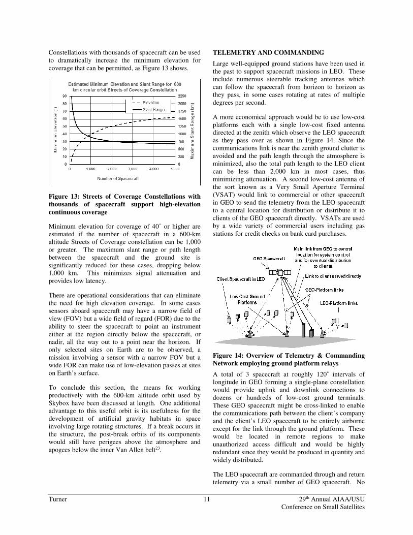
A more economical approach would be to use low-cost platforms each with a single low-cost fixed antenna directed at the zenith which observe the LEO spacecraft as they pass over as shown in Figure 14. Since the communications link is near the zenith ground clutter is avoided and the path length through the atmosphere is minimized, also the total path length to the LEO client can be less than 2,000 km in most cases, thus minimizing attenuation. A second low-cost antenna of the sort known as a Very Small Aperture Terminal (VSAT) would link to commercial or other spacecraft in GEO to send the telemetry from the LEO spacecraft to a central location for distribution or distribute it to clients of the GEO spacecraft directly. VSATs are used by a wide variety of commercial users including gas
stations for credit checks on bank card purchases.
Figure 14: Overview of Telemetry & Commanding
Network employing ground platform relays
A total of 3 spacecraft at roughly 120˚ intervals of longitude in GEO forming a single-plane constellation would provide uplink and downlink connections to dozens or hundreds of low-cost ground terminals. These GEO spacecraft might be cross-linked to enable the communications path between the client’s company and the client’s LEO spacecraft to be entirely airborne except for the link through the ground platform. These would be located in remote regions to make unauthorized access difficult and would be highly redundant since they would be produced in quantity and widely distributed.
The LEO spacecraft are commanded through and return telemetry via a small number of GEO spacecraft. No
Turner 12 29th Annual AIAA/USU Conference on Small Satellites
expensive crosslinks between LEO and GEO spacecraft are required and the LEO spacecraft need not carry any
crosslink antennas or other specialized equipment.
First-generation platforms would be located in remote areas on land with little or no maintenance. Later platforms would be aboard buoys at sea and include steerable dishes to maintain links with GEO spacecraft
as they drift.
Figure 15 shows that these low-cost ground platforms would be self-powered using solar arrays and batteries, therefore they are “off the grid” and are effectively
relay spacecraft on the ground.
Figure 15: Detail of ground platform relay
Figure 15 also shows that these platforms would include low-cost memory capability to buffer telemetry from the LEO spacecraft and commands en route to them. This permits data to be temporarily stored if a GEO spacecraft is in high demand by other users and a delay is required before it can be used for this purpose. Commands en route to a LEO spacecraft can be loaded
into the platform before the spacecraft comes into view.
The memory within the low-cost platforms can also be used by clients of the GEO spacecraft which services them for secure off-site back-up. A business could back up its payroll or other essential information through a VSAT terminal on its premises without transmitting it via the Internet. The GEO spacecraft would relay it to a platform or platforms for storage and would retrieve the stored data if requested by the business. The data would be encrypted to prevent
unauthorized use and to maintain privacy.
To conclude this section, the use of commercial GEO spacecraft in conjunction with economical ground platforms to provide inexpensive links for LEO
Smallsat clients is analogous to the use of GEO spacecraft to provide links for adjacent Smallsats in that high orbit, as discussed earlier in the high-altitude orbits section.
LAUNCH CONSIDERATIONS
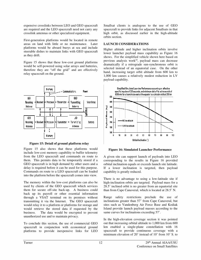
Higher altitude and higher inclination orbits involve lower launcher payload mass capability as Figure 16 shows. For the simplified vehicle shown here based on previous analysis work24, payload mass can decrease dramatically if a retrograde sun-synchronous orbit is selected instead of an equatorial case. On the other hand, increasing target orbit altitude from 600 km to 1,000 km causes a relatively modest reduction in LV
payload capability.
Figure 16: Simulated Launcher Performance
A given site can support launch of payloads into LEO corresponding to the results in Figure 16 provided orbital inclination equals or exceeds launch site latitude. If a lower inclination is targeted, then payload capability is greatly reduced.
There is no advantage to using a low-latitude site if high-inclination orbits are targeted. Payload mass for a 28.5˚ inclined orbit is no greater from an equatorial site
than from Cape Canaveral, which is located at 28.5˚ N.
Range safety restrictions preclude the use of inclinations greater than 57˚ from Cape Canaveral, but sites such as Vandenberg Air Force Base and Kodiak Island provide launch payload masses according to the
same curves for inclinations exceeding 57˚.
In the high-elevation coverage section it was pointed out that increasing orbital altitude to 1,000 km from 600 km enabled a single-plane constellation with 16 spacecraft to provide continuous coverage with a minimum elevation of 20˚ instead of 10˚ from 10˚ S. to
Turner 13 29th Annual AIAA/USU Conference on Small Satellites
10˚ N. latitude. Figure 16 shows that the estimated LV capability for 0˚ inclination drops from 435 to 340 kg as
orbital altitude is increased from 600 km to 1,000 km.
If the Smallsat mass were about 100 kg, four could be launched on the simulated LV to 600 km and three to 1,000 km. Establishing 16 spacecraft plus a few spares in the 600 km orbit would require 5 launches, while the number of launches to inject roughly the same number of Smallsats into the 1,000 km orbit would require only one additional launch. This might increase launch costs by 20%. The alternative of launching 40 spacecraft to provide coverage at 20˚ minimum elevation from an altitude of 600 km using the same LV would increase launch cost on the order of 200%, which is clearly disadvantageous. Therefore, consideration of raising altitude is recommended in such cases, provided that
mission needs can still be met.
It is unfortunate that the most useful orbits for global coverage, also for constant time of day coverage from LEO, namely highly inclined orbits and sun-synchronous orbits, correspond to the lowest LV payload capability. However, non-Earth coverage missions are expected to benefit from the relatively high payload capabilities from equatorial launch sites in the future.
END OF LIFE DISPOSAL CONSIDERATIONS
Spacecraft in LEO are taken directly to their operational orbits by launchers in many cases and carry minimal or possibly no propulsion. The need to dispose of the spacecraft 25 years after mission termination2 in compliance with national regulations and international guidelines necessitates including a propulsion or aerodynamic decelerator subsystem if altitude is above the 600 km regime featured in this paper, or if the spacecraft lies within this regime but has a low area-to-mass (A/m) ratio. To de-orbit a low A/m-ratio spacecraft perigee altitude would be lowered to about 350 km and air drag would then assure re-entry and destruction. The ∆V required to lower perigee to this low altitude from a circular orbit at 600 km is a
significant 70 m/s.
With the advent of space servicing it is possible that a spacecraft in a constellation may serve as an “undertaker.” This spacecraft would captive-carry units in the constellation not equipped with a propulsion subsystem through maneuvers to remove them to orbits with a low perigees to assure re-entry with the required 25 years. The undertaker would then disengage and return to the mission orbit where it could also assist with repositioning of spacecraft to make up for the
departure of retired units.
An undertaker could also facilitate targeted de-orbit of retired spacecraft. By lowering perigee to about 100 km, which would require a ∆V of 140 m/s from a 600 km altitude, the spacecraft can be caused to re-enter on a single perigee pass. The re-entry point can therefore be targeted to occur at mid-ocean, most favorably at high southerly latitude for highly inclined orbits, in any case far away from populated regions. It can also be scheduled to occur at times when no ships or aircraft are in the target area. Notices would be sent to
authorities administering these vehicles.
The combination of the launcher and the undertaker would provide cradle-to-grave support for lower-cost spacecraft that are not equipped with propulsion subsystems, or that carry minimal propulsion to support
only modest on-orbit maneuvers.
Acknowledgements
The support of Matteo Genna, Vice President, Product Strategy and Development and CTO of SSL is greatly
appreciated.
References
1. A.E. Turner, Power Transfer for Formation Flying Spacecraft, Space 2006 Conference, San Jose, CA 19-21 September 2006, AIAA 2006-7493.
2. NASA Standard 8719.14, Process for Limiting Orbital Debris, NASA Orbital Debris Program Office, Johnson Space Center, Houston, TX http://www.hq.nasa.gov/office/codeq/doctree/871914.pdf, accessed 25 May 2016.
3. U.S. Patent 5,582,367, Elliptical orbit satellite, system, and deployment with controllable coverage characteristics, David Castiel, John E. Draim, Jay Brosius, issued 10 December 1996.
4. U.S. Patent 5,326,054, Apogee at constant time-of-day equatorial (ACE) orbit, Andrew E. Turner, issued 5 July 1994.
5. Gregory Lemieux and Andrew E. Turner, SSL Commercial Geosynchronous Spacecraft Orbit Raising Considerations, 26th AAS/AIAA Space Flight Mechanics Meeting, Napa, California, 14-18 February 2016, AAS 16-301.
6. Andrew E. Turner, Eaglet: A Geosynchronous Orbit Formation Flying Concept, Space 2010 Conference, San Diego, CA, 14-17 February 2010, AAS 10-263.
7. Andrew E. Turner, Geosynchronous Orbit via the Moon: Phasing Loops to Permit Daily Launch, Space 2010 Conference, San Diego, CA, 14-17 February 2010, AAS 10-130.
Turner 14 29th Annual AIAA/USU Conference on Small Satellites
8. Andrew E. Turner, Molniya/Tundra Orbit Constellation Considerations for Commercial Applications, AAS-01-215, AAS/AIAA Space Flight Mechanics Conference, February 2001, Santa Barbara
9. U.S. Patent 6,564,053, Efficient high latitude service area satellite mobile broadcasting systems, Robert D. Briskman, Robert A. Nelson, issued 13 May 2003. (Tundra orbit).
10. John E. Draim and Paul J. Cefola, Beyond GEO II: Raindrop Elliptical Orbit Constellation for Frequency Re-use, 26th International Communications Satellite Systems Conference (ICSSC), San Diego, California, 10-12 June 2008, AIAA 2008-5415.
11. U.S. Patent Application 13/876,678, Satellite system and method for circumpolar latitudes, US 20140017992 A1, Andre E. Bigras et. al., published 16 January 2014 (Polar Tundra orbit).
12. http://sservi.nasa.gov/wp-content/uploads/2014/04/Staehle-presentation-Lunar-Flashlight-20131109.pdf, accessed 25 May 2016
13. Arthur C. Clarke, Extra-Terrestrial Relays, Wireless World, vol. 11, no. 10, October 1945.
14. https://terrabella.google.com/?s=about-us&c=about-satellites, accessed 25 May 2016.
15. http://atrain.nasa.gov/, accessed 25 May 2016
16. J.G. Walker, Continuous Whole-Earth Coverage by Circular-Orbit Satellite Patterns, Royal Aircraft Establishment Technical Report 77044, 24 March 1977.
17. Andrew E. Turner, Constellation Design using Walker Patterns, AIAA/AAS Astrodynamics Specialist Conference and Exhibit, 5-8 August 2002, Monterey, California, AIAA 2002-4636.
18. A.E. Turner, J.J. Rodden, M. Tse, L.A. Barker, GlobalstarTM Constellation Design and Establishment Experience, AAS/AIAA Astrodynamics Specialists Conference, Big Sky, Montana, August 3-7, 2003, AAS 03-636.
19. https://en.wikipedia.org/wiki/Iridium_satellite_constellation, accessed 25 May 2016.
20. A. H. Ballard, Rosette Constellations of Earth Satellites, IEEE Transactions on Aerospace and Electronic Systems, Vol AES-16, No. 5, September 1980.
21. Mortari, D., Aerospace Space Technologies and Applications for Dual Use (a New World of Defense and Commercial in 21st Century
Security), Series in Communications. Chapter “Dual Use Technologies, Optimisation of Flower Constellations for Dual Use,” Editors: Finocchio, P. Prasad, R., and Ruggieri, M. ISBN: 978-87-92329-04-2, River Publishers, 2008. Part 2 – Dual Use Technologies, Section 13.
22. GOES I-M DataBook, prepared for: NASA-GSFC, Greenbelt, MD, Pursuant to: DRL 101-08, GSFC Specification S-480-21A, Contract NAS5-29500.
23. Andrew E. Turner, Orbit Dynamics and Habitability Considerations for a Space Hotel with Artificial Gravity, AIAA Space 2014 Conference and Exposition, San Diego, California, 4-7 August 2014, AIAA 2014-4403.
24. Andrew E. Turner, Pressure-Fed vs. Pump-Fed Propulsion Trade for the Aquarius Launch Vehicle, 45th AIAA/ASME/SAE/ASEE – Joint Propulsion Conference and Exhibit, Denver, Colorado, 2-5 August 2009, AIAA 2009-4898.