content pages x-final - sakshieducation.com: current...
TRANSCRIPT

Social Studies44 Climate of India
CHAPTER
4
Climate and WeatherThe state of atmospheric conditions over an area at a particular time refers
to weather. These weather conditions fluctuate very often even in a short period.Climate refers to such conditions over a large area and follows a similar generalpattern over many years. What have been the general conditions, year after year,over thirty years or more, gives us the climate. There are variations from year toyear but a basic pattern remains the same. On the basis of these generalisedconditions, the year is divided into seasons. The elements of weather and climateare: temperature, atmospheric pressure, wind, humidity, and precipitation. Thepattern of these for a place can be shown using pictures called climographs orclimatographs. Climographs show average monthly values of maximumtemperature, minimum temperature, and rainfall for a given place.
Collect similar newspaper reports.Are these indicators of some change or just a variation that happen once in a
long time? Invite some meteorological officials or college faculty to discuss thesedevelopments.
Freak weather offshoot of climate change: Experts
After observing suchunforeseen situationslike extreme summer inthe country, suddenhailstorm in Chevellaregion of Ranga Reddydistrict, cloudbursts inUttarakhand and earlyonset of southwestmonsoon and a lateretreat, experts say thatweather systems arebehaving in a peculiarway.
Ongole received 341mm rainfall in one day,which is more than one-third of the state's totalannual rainfall. The heavyshowers across the statehave damaged severalacres of crops,particularly cotton. Butin a good news, 75% ofthe around 80,000 tanksin Andhra Pradesh arefull now.(adapted from Oct 25,2013 Times of India)
Intermittent showers inHyderabad havebewildered Meteorologi-cal officials, while climatechange experts said it isincreasingly becomingdifficult to predict futureweather events in thecountry. For the last twoyears, we have noticedthat the weather systemsare behaving in a peculiarway resulting in unusualweather events.
Climate of India

Free distribution by A.P. Government 45
Climographs of a few places in India.The climographs below show that temperature and rainfall vary in different
parts of the country. Refer to your atlas and identify the relief region where theseplaces are located. Also, read the graphs below and fill the table on following page.
Mean Maximum Temperature (0C)
Mean Minimum Temperature (0C) Mean Rainfall (mm)
All Graphs Courtesy: The Indian Institute of Geographical Studies.(CC)2013
Graph 1 to 4 : Climographs
Janu
ary
Febr
uary
Mar
ch
Apr
il
May
June
July
Aug
ust
Sept
embe
r
Oct
ober
Nov
embe
r
Dec
embe
r
Janu
ary
Febr
uary
Mar
ch
Apr
il
May
June
July
Aug
ust
Sept
embe
r
Oct
ober
Nov
embe
r
Dec
embe
r
Janu
ary
Febr
uary
Mar
ch
Apr
il
May
June
July
Aug
ust
Sept
embe
r
Oct
ober
Nov
embe
r
Dec
embe
r
10
9
8
7
6
5
4
3
2
1
0
40
30
20
10
0
-10
-20
250.0
200.0
150.0
100.0
50.0
0.0
40
35
30
10
20
15
10
5
0
400.0
350.0
300.0
250.0
200.0
150.0
100.0
50.0
0 .0
40
35
30
25
20
15
10
5
0
Janu
ary
Febr
uary
Mar
ch
Apr
il
May
June
July
Aug
ust
Sept
embe
r
Oct
ober
Nov
embe
r
Dec
embe
r
250.0
200.0
150.0
100.0
50.0
0 .0
45
40
35
30
25
20
15
10
5
0

Social Studies46 Climate of India
Factors influencing climate and weatherIt is observed that for some places (e.g. Chennai) there is not much difference
in the temperature across months. Some places (e.g. Delhi) have wide differencesin temperature across the months. India experiences wide variations in temperature.The northern portion is bounded by the Himalayas whereas southern peninsula issurrounded by seas. Some places are far from the coasts; they are inland. Someplaces are at high altitude, whereas others are on the plains. The factors that affectclimate are called climatic controls. These include:
1. Latitude 2. Land-water relationship 3. Relief 4. Upper air circulation
1. Latitude or distance from the equatorThe average temperatures for the year drop as you go further away from the
equator. For this reason, we divide the regions on Earth as:• Tropical, as those close to the Equator;• Polar, as those close to the poles;• Temperate, as those in between these two extremes.If we compare the climate of, say, Indonesia and Japan, we can understand the
What are the warmest and coldest months in Leh?From the range of temperatures in the above table say whether Jaipur is, in general,hotter than Leh. Explain your answer.Compare the climate of Delhi and Chennai. How are they different?Read carefully the rainfall pattern for Leh. In what ways is this different fromthe others? From your atlas can you find out some other places in the world thathave similar rainfall pattern.Identify the wet months for Chennai. How is this different from Jaipur?
Place Reliefregion
Range ofm a x i m u mtemperature,during the year
Range of minimumt e m p e r a t u r e ,during the year
Name the wettestmonth and therainfall (mm) forthat month
Name the driestmonth and therainfall (mm) forthat month
Jaipur
Leh
New Delhi
ChennaiRange of Temprature: From highest value to lowest value

Free distribution by A.P. Government 47
differences. The reason for these differences is the differential heating of Earththat you have read in earlier classes. Intensity of temperature depends on the latitude.
The temperature of the atmosphere at a particularplace near the Earth’s surface depends upon theinsolation (heat from sun rays) received at thatlocation. This is more intense in the low latitudesthan in the high latitudes. As we move away fromthe equator towards the poles, the average annualtemperature decreases.
In India the southern part lies in thetropical belt closer to the equator. Thereforethis region has higher average temperaturethan the northern part. This is one reason forthe climate of Kanyakumari being entirelydifferent from Bhopal or Delhi. India issituated roughly between 8o and 37o Nlatitudes and the country is divided into almosttwo equal parts by the Tropic of Cancer. Thepart south of the Tropic of Cancer lies in thetropical zone. The part north of the Tropic ofCancer lies in the temperate zone.
Land water relationshipLook at a map of India showing land cover
and water bodies, and you will see anotherimportant factor which has an influence onclimate: the land and water relationship . Theamount of sunlight that is first absorbed andthen radiated back or directly reflecteddepends on the nature of the surface. Darkerareas, such as heavily vegetated regions, tendto be good absorbers; lighter areas, such assnow and ice-covered regions, tend to be goodreflectors. The ocean absorbs and loses heatmore slowly than land. This affects climatein many ways. One of this is the formation ofland and sea breezes. Using Fig 4.2 explainhow this happens. Recall from class IX theconnection between pressure and direction ofwind.
Using a globe recall anddiscuss what you may haveread earlier. How does theangle of sun vary at differentlatitudes? What impact doesthis have?
Fig 4.1 : Influence of latitude on climate
Fig 4.2 : How does this ‘moderate’ thetemperature of such a place?
Night
Day
warm air
cool sea breeze
land warmer see cooler
cool land breeze warm air
land cooler sea warmer

Social Studies48 Climate of India
A large part of southern India, becauseof its long coast line, comes under themoderating influence of the sea. As such,the difference between the temperature ofday and night and that of summer and winteris not much. This is known as equableclimate. If we compare similar places on thesame latitude and altitude we can appreciatethe effect of the sea.
ReliefYou have learnt that temperature decreases as altitude increases. Hence, hills
and mountains will have lower temperature than locations on the plain. Therefore,relief or altitude of a region influences theclimate of the area. You would have heardabout several hill stations of the Himalayanregion like Shimla, Gulmarg, Nainital andDarjeeling as places that have a cool climateeven during the peak summer months.Similarly Kodaikanal and Udagamandalam(Ooty) have cooler climate, compared toplaces near the coast.
Upper atmospheric circulationIn the northern hemisphere, subtropical high pressure belt gives rise to
permanent winds. They blow toward the equatorial low pressure belt by reflectingtowards the west and are called trade winds. The German word ‘trade’ means ‘track’and stands for blowing steadily in the same direction and in a constant course.India lies in the belt of dry north-east trade winds.
The climate of India is also affected by the movement of upper air currentsknown as ‘jet streams’. These are fast flowing air currents in a narrow belt in theupper atmosphere, above 12,000 m. The speed varies from about 110 km/h insummer to about 184 km/h in winter. An easterly jet stream develops at about250N. A jet stream causes the neighbouring atmosphere to cool. This cooling effectof the easterly jet stream causes rain from clouds already found over this latitude(250N).
Seaons: WinterThe temperature in the Indian land mass considerably reduces from mid-
November and this cold season continues till February. January is usually thecoldest month-day temperature sometimes drops below 100C in several parts ofthe country. However, the cold weather is more pronounced in northern India. South
In your atlas, compare thetemperatures of Mumbai and Nagpurfor winter and summer months. Howare they similar or different? Howdoes it explain distance from the sea?With the help of the climographs canyou explain the differences intemperature for Jaipur and Chennai.
Are Shimla and Delhi located on verydifferent latitudes? Check with youratlas. Is Shimla cooler than Delhiduring summer?Why does Darjeeling have pleasantweather as compared to Kolkataduring summer season?

Free distribution by A.P. Government 49
India, especially the coastal areas, enjoy a moderate climate as temperature remainswell above 200 C.
The lines in map 1 below indicateplaces that have the same averagetemperature for January.
During winter, the weather isgenerally pleasant with clear sky, lowhumidity and cool breeze. Cyclonedepressions coming fromMediterranean Sea called WesternDisturbances cause low to moderaterainfall over northern India. This rainfall
is boon to wheat crop which is generally cultivated in ‘Rabi’ season.India lies in the trade wind belt of Northern Hemisphere – north-east trades
blow over India from land to sea and are therefore dry. However, some amount ofrainfall occurs on the Coramandel coast of Tamil Nadu from these winds, as theypick up moisture from the Bay of Bengal while crossing it.
What would be the range for the averagetemperature in A P for January?Using your atlas find some places locatedon 150C.
Close to the line showing places whereaverage temperature is 250C, there’s asmall circle of places on 200C. How isthis possible?
Map 1 : India AverageTemparature (0C) January

Social Studies50 Climate of India
SummerDuring the hot season,
as we move from southernto northern part of thecountry, the averagetemperature increases.Starting in April, thetemperature rises andslowly the maximum daytemperature exceeds 370 Cin northern plains of India.By mid-May, daytemperature may touch 410
C to 42 0 C in many partsof the country, especiallyin the north-west plainsand central India. Evenminimum temperaturedoes not go below 200 C.The northern plainexperiences dry and hotwinds called ‘Loo’.
Towards the end of thesummer season, pre-monsoon showers(‘bursting monsoon’) are common in theDeccan Plateau. These help in the earlyripening of mangoes and other plantationcrops in peninsular India. Hence they arelocally known as mango showers in Andhra Pradesh.
Advancing monsoonThe climate of India is strongly influenced by the monsoon winds. The sailors
who came to India during olden days noticed the regular periodic reversal of winds.They used these winds to sail towards the Indian coast. Arab traders named thisseasonal reversal of wind system ‘monsoon’.
The monsoon forms in the tropical area approximately between 200 N and 200
S latitudes. The south-east monsoon winds from the southern hemisphere carrymoisture as they flow over the Indian Ocean and towards the equatorial low pressurezones. After crossing the equator, these winds deflect towards the low pressureformed in the Indian sub-continent. The heating of land creates low pressure on theland mass of Indian sub-continent, especially over central India and the Gangetic
Map: 2.4 Average Temperaturein 0C (May)
From the climographs (Graph 1-4), notethe approximate average temperature forMay for the four places and mark themon the above map.
Map 2 : India Average
Temparature (0C)
in the month of May

Free distribution by A.P. Government 51
plain. Together with this, the Tibetan plateau gets intensely heated and causes strongvertical air currents and the formation of low pressure over the plateau at above 9kms altitude.
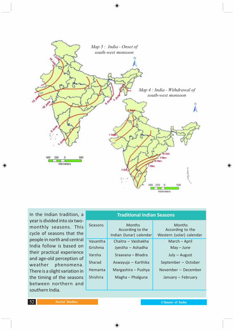
They then flow as the southwest monsoon. The Indian peninsula divides theminto two branches - the Arabian Sea branch and the Bay of Bengal branch. The Bayof Bengal branch strikes the Bengal coast and the southern face of the Shillongplateau. Then it gets deflected and flows westward along the Gangetic valley. TheArabian Sea branch arrives at the west coast of India and moves north ward. Boththe branches reach India by the beginning of June, which is known as “onset ofmonsoon”. They gradually spread over the entire country in four to five weeks. Thebulk of the annual rainfall in India is received from south-west monsoon. The amountof rainfall is very high along the west coast due to the Western ghats, and in north-east India due to the high peaked hills. Tamil Nadu coast (Coramandel), however,remains mostly dry during this season as it is in the rain shadow area of the ArabianSea branch and is parallel to the Bay of Bengal branch.
Retreating MonsoonOctober - November is a period of transition from a hot wet conditions to dry
winter condition (Fig 4.7). The retreat of the monsoons is marked by clear skiesand rise in temperature. The land is still moist. Owing to the conditions of hightemperature and humidity, the weather becomes rather oppressive. This iscommonly known as “October heat”.
The low pressure conditions which once prevailed over north-western Indiamove far South to the centre of the Bay of Bengal by early November. During thisperiod cyclonic depressions are common which originate over the Andaman area.These tropical cyclones are often very destructive. The thickly populated deltas ofthe Godavari, Krishna and Cauveri are their targets. No year is ever found disasterfree. Occasionally, these tropical cyclones visit Sundarbans and Bangladesh too.Bulk of the rainfall of the Coromandel Coast is derived from depressions andcyclones.
HighPressure
LowPressure
NorthEast
Monsoon
South WestMonsoon
January July
Fig 4.3 : Pressure and monsoon wind
Social Studies52 Climate of India
Map 3 : India - Onset ofsouth-west monsoon
Map 4 : India - Withdrawal ofsouth-west monsoon
Seasons Months Months According to the According to the
Indian (lunar) calendar Western (solar) calendar
Vasantha Chaitra – Vaishakha March – April
Grishma Jyestha – Ashadha May – June
Varsha Sraavana – Bhadra July – August
Sharad Aswayuja – Karthika September – October
Hemanta Margashira – Pushya November – December
Shishira Magha – Phalguna January – February
In the Indian tradition, ayear is divided into six two-monthly seasons. Thiscycle of seasons that thepeople in north and centralIndia follow is based ontheir practical experienceand age-old perception ofweather phenomena.There is a slight variation inthe timing of the seasonsbetween northern andsouthern India.
Traditional Indian Seasons

Free distribution by A.P. Government 53
Global Warming and Climate ChangeAs Earth started to take shape from a fire ball to a planet, many gases were
released. These gases did not escape into outer space because of the Earth’sgravitational pull. It still holds them back. The result? A thin layer of gases surroundsEarth and provides us several important benefits. For example: the oxygen that webreathe, the ozone that protects us from harmful ultraviolet rays from the sun, thenitrogen that our plants use to make proteins that we need, the medium throughwhich fresh water is circulated, and keep us warm (look at the image from Class IXChapter 4).
Keeping us warm is one of the most important things that the atmosphere doesfor us. It is like a light, but effective, blanket enveloping Earth. You will recall fromClass IX that the atmosphere traps a lot of the solar energy that reaches Earth bypreventing it from totally escaping back into space. This is called Green houseeffect. This is important and vital for life to survive on this planet. If it did not havethis atmosphere, earth would be very cold indeed.
However, since the 19th century the planet has been warming up very rapidly.There is an increasing concern about this. Why this concern? After all, Earth hasbeen through many cycles of warming and cooling (in fact, freezing!). So what isso special about it now?
Earlier cycles of cooling and warming happened over very long periods of time.This allowed much of the life on Earth the time to adapt to the changes. The problemnow is that the heating is much more rapid and could lead to catastrophic changes.Much of the warming that has been occurring since the Industrial Revolution isbecause of human activities. Hence, the current global warming trend is calledAGW (Anthropogenic Global Warming; anthropogenic means caused by humans).
More recently, scientists are discovering large volumes of methane under thefrozen tundras of the far northern latitudes (mainly in the vast expanses of northernRussia). As global temperature increases, the ice in the tundra melts more. Themethane that is trapped under the ice escapes into the atmosphere, increasing theglobal temperatures. In turn, this causes even more ice to melt, releasing evenmore methane, and so on. Methane is said to be even more powerful than carbondioxide as a greenhouse gas.
AGW and climate changeAGW is causing many changes in the distribution of heat in the Earth system.
Remember how atmospheric and oceanic circulations keep re-distributing the heatin the world? AGW disturbs this system and the re-distribution system. Thedisturbance itself is not so much of a problem. It is the rapidity with which it ishappening.
When the redistribution system is disrupted, weather and climate patterns

Social Studies54 Climate of India
change. Long-term changes (climatic changes) happen from accumulations of short-term changes (weather changes).
An international effort to form an agreement whereby all countries try to reducetheir emission of greenhouse gases has so far not been achieved. An internationalorganization called Inter-governmental Panel on Climate Change (IPCC) wasformed to address this issue. It has held many conferences to work out a treatyamong the nations of the world to reduce AGW and try to slow down the processof climate change. None of these have been successful. The latest attempt wasmade at the IPCC conference in Warsaw (Poland), in 2013. This has also failed toachieve any agreement.
Broadly, the disagreements are between the ‘developed’ countries (mainlyindustrialised, economically more advanced countries of the West) and ‘developing’countries (countries that are not as industrialised). Developed countries wantdeveloping countries to cut down on burning coal and other activities that addgreenhouse gases to the atmosphere. Developing countries argue that developedcountries developed precisely by burning fossil fuels in their development.Developing countries say that their economic development will be seriouslydamaged if they don’t burn fossil fuels(mainly coal), and that developedcountries should do their fair share ofwork to help find alternatives that canhelp the developing countries toprogress.
Most scientists from around theworld agree on this much: AGW is real,it is happening, and it is leading to rapidand drastic climate change. They warnthat severe weather and other changeswill increase in the coming years andthreaten life as we know it.
One of the human activities thatcontribute to global warming is deforestation. Discuss with your teacher and yourclassmates and try to answer the questions on the right in a few sentences.
Impact of climate change on IndiaThough a rise of 20 C in average temperature may appear to be small, it
would result in a rise of one meter in sea levels by early next century. This wouldaffect large portions of our coastal areas and millions of people would have to beshifted. They would lose their livelihood.
What is deforestation?Does deforestation happen only in forestareas? How about in your local area, evenif there are no forests?How does deforestation affect globalwarming? (You will need to recall yourstudy of photosynthesis in your scienceclass.)What are some other ways in whichhuman action contributes to globalwarming?

Free distribution by A.P. Government 55
Nearly 200 squatter families living in Nonadanga in east Kolkata for the pastfew years are in the process of being evicted by the Kolkata MetropolitanDevelopment Authority (KMDA). Many of the families came to Kolkata in searchof work, after the Aila super-cyclone ravaged Sundarbans in 2009.
On March 30, the slum was bulldozed amid heavy police presence and somehutments were set on fire. The recurrent thunderstorms over the past few dayshas meant sleepless and soiled nights for nearly 700 people who have been ren-dered homeless. They work as house helps, rickshaw pullers and constructionlabourers.
The other effect would be on rainfall. This is likely to be more erratic and leadto greater imbalances: some places are likely to receive excess rainfall whereasothers would get less than normal. Hence droughts and floods are expected toincrease. This would greatly affect the agriculture pattern and people’s livelihood.
The faster melting of Himalayanglaciers would disturb the livelihood offresh water fisher folk as their naturalhabitat of fish is affected. Similarly freakweather conditions that you read
about are likely to increase. Climatechange is something that happensat a global level. Therefore, it affectsall of us.
Fig 4.8 : Impact of Aila : (left)broken embankment, (below)
repairing embankment
Imagine how one would cope with asituation, if millions of people wereaffected. Where would you find land forresettlement? What jobs would they do?

Social Studies56 Climate of India
Improve your learning1) Read the following statements and mark if it is an example of weather or climate
a) During the last few years many glaciers have melted in Himalayasb) During the last few decades drought in Vidarbaha region has increased
2) Match the following. Use maps if you cannot locate the places. (Therecould be multiple correct answers)
a) Trivandrum is farther from the equator and temperaturewould be lower in winter
b) Gangtok is closer to the equator but not close to theseas and has low rainfall
c) Anantapur is closer to sea, and climate has bigimpact of the seas
3. Describe India’s climate controls.
4. Write a short note on factors influencing climatic variations in hilly areas anddeserts.
5. How are human activities contributing to global warming?
6. What are disagreements between ‘developed’ and ‘developing’ countries about AGW?
7. How is climate change causing global warming? Suggest measures to minimise theinfluence of the global warming.
8. On an outline map of India, show the following:(i) Areas recorded with more than 400C annual mean temperature(ii) Areas recorded with annual mean temperature less than 100C(iii) The direction of the south-west monsoon over India.
9. Observe the following climograph and answer the following questions.A. Which month received highest rainfall?B. Which months experience highest and lowest temperature?C. Why is the maximum amount of rainfall between June and October?D. Why is the temperature high between March and May?E. Identify relief conditions causing variation in temperature and rainfall.
Key wordsClimograph Weather Monsoon InsolationJet Streams Pressure Zone Global warming

Free distribution by A.P. Government 57
Mean Maximum Temperature (0C)
Mean Minimum Temperature (0C) Mean Rainfall (mm)
Cour
tesy
: Th
e In
dian
Inst
itute
of G
eogr
aphi
cal S
tudi
es.(C
C)20
13
Janu
ary
Febr
uary
Mar
ch
Apr
il
May
June
July
Aug
ust
Sept
embe
r
Oct
ober
Nov
embe
r
Dec
embe
r
200.0
180.0
160.0
140.0
120.0
100.0
80.0
60.0
40.0
20.0
0.0
45
40
35
30
25
20
15
10
5
0
ProjectCollect proverbs/ sayings that are related to climate and weather in your region.
A Rainbow in the morning is the Sailor’s Warming.A Rainbow at night is the Sailor’s delight.\When the dew is on the grass rain will never come to pass.