contrasting geometric and dynamic evolution of lake and...
TRANSCRIPT

This is a repository copy of Contrasting geometric and dynamic evolution of lake and land-terminating glaciers in the central Himalaya.
White Rose Research Online URL for this paper:http://eprints.whiterose.ac.uk/131215/
Version: Published Version
Article:
King, O, Dehecq, A, Quincey, D orcid.org/0000-0002-7602-7926 et al. (1 more author) (2018) Contrasting geometric and dynamic evolution of lake and land-terminating glaciers in the central Himalaya. Global and Planetary Change, 167. pp. 46-60. ISSN 0921-8181
https://doi.org/10.1016/j.gloplacha.2018.05.006
© 2018 Published by Elsevier B.V. This is an author produced version of a paper publishedin Global and Planetary Change. Uploaded in accordance with the publisher's self-archiving policy. This manuscript version is made available under the Creative Commons CC-BY-NC-ND 4.0 license http://creativecommons.org/licenses/by-nc-nd/4.0/
[email protected]://eprints.whiterose.ac.uk/
Reuse
This article is distributed under the terms of the Creative Commons Attribution (CC BY) licence. This licence allows you to distribute, remix, tweak, and build upon the work, even commercially, as long as you credit the authors for the original work. More information and the full terms of the licence here: https://creativecommons.org/licenses/
Takedown
If you consider content in White Rose Research Online to be in breach of UK law, please notify us by emailing [email protected] including the URL of the record and the reason for the withdrawal request.

Contents lists available at ScienceDirect
Global and Planetary Change
journal homepage: www.elsevier.com/locate/gloplacha
Research article
Contrasting geometric and dynamic evolution of lake and land-terminating
glaciers in the central Himalaya
Owen Kinga,⁎
, Amaury Dehecqb, Duncan Quinceya, Jonathan Carrivicka
a School of Geography, University of Leeds, Leeds LS2 9JT, UKbNASA Jet Propulsion Laboratory, Pasadena, CA 91109, USA
A R T I C L E I N F O
Keywords:
Glacial lakes
Himalaya
Glacial lake outburst floods
Digital elevation model
Glacier velocity
A B S T R A C T
The impact of glacial lake development on the evolution of glaciers in the Himalaya is poorly quantified, despite
the increasing prevalence of supraglacial and proglacial water bodies throughout the region. In this study we
examine changes in the geometry, velocity and surface elevation of nine lake-terminating and nine land-ter-
minating glaciers in the Everest region of the central Himalaya over the time period 2000 to 2015. The land-
terminating glaciers we examined all decelerated (mean velocity change of −0.16 to −5.60m a−1 for different
glaciers), thinned most in their middle reaches, and developed a more gently sloping surface (−0.02 to −0.37°
change) down-glacier over the period 2000–2015. The lake-terminating glaciers we examined all retreated (0.46
to 1.42 km), became steeper (0.04 to 8.68° change), and showed maximum thinning towards their termini, but
differed in terms of their dynamics, with one group of glaciers accelerating (mean speed-up of 0.18 to 8.04m
a−1) and the other decelerating (mean slow-down of −0.36m a−1 to −8.68m a−1). We suggest that these two
scenarios of glacier evolution each represent a different phase of glacial lake expansion; one that is accompanied
by increasingly dynamic glacier behaviour and retreat, and a phase where glacial lakes have little impact on
glacier behaviour that may precede or follow the phase of active retreat. Our observations are important because
they quantify the interaction of glacial lake expansion with glacier ice mass loss, and show that increased glacier
recession should be expected where a glacial lake has begun to develop.
1. Introduction
The number and size of proglacial (moraine- and ice-dammed) lakes
has increased dramatically across the Hindu Kush Karakoram Himalaya
(HKKH) in recent decades (Zhang et al., 2015; Nie et al., 2017), and
their expansion has been associated with areal and volumetric reduc-
tions in glacier extent (Basnet et al., 2013; King et al., 2017; Wang
et al., 2017). The presence of a glacial lake may be indicative of a
glacier in its most advanced state of recession (Sakai and Fujita, 2010;
Benn et al., 2012), thus glacial lakes may become populous in high
mountain regions as precipitation and temperature changes continue.
Glacial lakes are particularly likely to form where substantial moraine
dams have been constructed during glacial maxima (Benn et al., 2012).
Ice mass loss rates from marine- and lake-terminating glaciers have
been shown to be elevated above their land-terminating counterparts
elsewhere in the world (Truffer and Motyka, 2016; Willis et al., 2012;
McNabb and Hock, 2014; Tsutaki et al., 2016; Melkonian et al., 2016),
and their flow characteristics have been found to be contrasting (Willis
et al., 2012; Burgess et al., 2013). If simulations of Himalayan glacier
evolution over coming decades are to be robust, it is therefore im-
perative that we improve our understanding of the response of Hima-
layan glaciers to glacial lake growth.
At present, knowledge of Himalayan glacial lakes and their impact
on the dynamics of their host glaciers remains relatively limited. Nie
et al. (2017) documented 2.7, 51.7 and 366.6% increases in the total
area of glacier fed but unconnected, proglacial and supraglacial lakes,
respectively, between 1990 (n=4549) and 2015 (n=4950) across the
entire HKKH. Reynolds et al. (2000), Quincey et al. (2007), and Sakai
and Fujita (2010) identified a set of glacier surface characteristics
conducive to supraglacial lake formation. They suggested that melt-
water ponding and pond coalescence is most likely where the glacier
surface has a surface gradient of< 2° and a negligible velocity, with
steeper, faster glacier surfaces liable to meltwater runoff and/or frac-
turing that would promote meltwater drainage. Thakuri et al. (2016)
examined the evolution of one lake-terminating glacier in the Everest
region- Imja Tsho, showing an increased surface lowering rate, but
decreased surface velocity over Imja and Lhotse Shar Glaciers between
2001 and 2014 and 1992/93 to 2013/14, respectively. King et al.
https://doi.org/10.1016/j.gloplacha.2018.05.006
Received 16 November 2017; Received in revised form 11 May 2018; Accepted 15 May 2018
⁎ Corresponding author.
E-mail address: [email protected] (O. King).
Global and Planetary Change 167 (2018) 46–60
Available online 24 May 20180921-8181/ © 2018 Published by Elsevier B.V.
T

(2017) generated glacier mass balance estimates for 32 glaciers in the
Everest region of the Himalaya over the period 2000 to 2015 and
showed 32% greater mass loss from lake-terminating glaciers when
compared with land-terminating glaciers. King et al. (2017) also show
amplified surface lowering rates and opposing surface lowering gra-
dients over lake versus land-terminating glaciers.
Glacial lakes present a considerable societal hazard to communities
downstream due to their susceptibility to catastrophic drainage and the
release of a glacial lake outburst flood (GLOF) (Fujita et al., 2013).
Carrivick and Tweed (2016) compiled a record of 216 glacier flood
events from 78 different sites in central Asia (since ~1500 CE) and
ranked central Asian countries as most susceptible in a damage index
considering recorded deaths, evacuations, and property and infra-
structure destruction and disruption. In a region-wide study of glacial
lake growth in the Himalaya, Nie et al. (2017) identified 118 rapidly
expanding lakes that may be a priority for risk assessment. Rounce et al.
(2017) identified 131 glacial lakes in Nepal with an area of> 0.1 km2,
and attempted to categorise glacial lakes based on their outburst
probability, and considered the effects of lake expansion on the like-
lihood of lake failure. Rounce et al. (2017) classified 11 ‘very high risk’
lakes and 31 ‘high risk’ lakes. Rounce et al. (2017) identified Imja Tsho
(in the Everest region) as a lake that will become increasingly ha-
zardous, citing lake expansion towards more avalanche prone terrain as
the primary factor increasing the chance of an outburst flood occurring.
Using an alternative hazard assessment framework, ICIMOD (2011)
identified 49 hazardous, and 21 critically hazardous glacial lakes (out
of 1466) in Nepal. Concern over the hazard posed by glacial lakes has
seen major remediation efforts to stabilise moraine dams and lower lake
levels at several sites in recent decades (Reynolds et al., 2000; Rounce
et al., 2017), underlining the importance of understanding their likely
evolution as climate in the region continues to change (Sakai and Fujita,
2010; Yang et al., 2011; Salerno et al., 2015).
In this study we examine the evolution of nine lake-terminating and
nine land-terminating glaciers in the Everest region of the central
Himalaya, which is a region that has experienced a 20% increase in lake
area from 2000 to 2009 (Gardelle et al., 2011). The primary research
question we pose is whether changes in glacier velocity, geometry, and
rates of mass loss over the period 2000 to 2015 differ based on terminus
type. We use observations of surface dynamics and morphology to ex-
amine the processes that may be driving glacier change in this region.
Finally, we demonstrate how these data can be used to highlight gla-
ciers that are preconditioned for glacial lake formation or lake expan-
sion in the imminent future.
2. Study area
Glaciers of the Everest region (Fig. 1) can be broadly grouped into
three categories:
1. Large land-terminating glaciers flowing down from mountain
massifs such as Everest, Lhotse, Cho Oyu and Makalu (all > 8000
m a.s.l.) that terminate on land and account for the greatest portion of
glacierised area. These glaciers vary in length, ranging from 1 to 2 km
to> 10 km long. These glaciers are flanked by large Little Ice Age (LIA)
moraines and are mantled by debris layers up to several metres in
thickness (Nakawo et al., 1986, 1999).
2. Lake-terminating glaciers that vary in size and surface cover. Lake
areas vary from<1 km2 to nearly 4 km2, debris-cover ranges from 0 to
100%, and glacier length ranges from 3 to 12 km. The majority of
glacial lakes are proglacial, although large supraglacial lakes have re-
cently developed on Rongbuk and Drogpa Nagtsang glaciers (Fig. 1).
3. Numerous smaller, clean ice glaciers located at high elevation
(> 5000m a.s.l.), mostly north of the orographic divide in the Everest
region. These glaciers do not typically host glacial lakes and have only
retreated a small amount from their LIA limits. We do not focus on
glaciers of this type in this study.
The nine glaciers we classify as lake-terminating are Imja/ Lhotse
Shar, Yanong, Yanong North, Kada, Drogpa Nagtsang, Trakarding,
Longmojian, Duiya and Hunku glaciers (Fig. 1, Table S1). These glaciers
all have well-developed glacial lakes which are dammed by a full
moraine loop, and lose mass through calving as well as melt (Benn
et al., 2001; Somos-Valenzuela et al., 2014). We do not classify glaciers
that host supraglacial lakes as lake-terminating as we cannot be certain
of the depth of these lakes and whether they are directly influencing
glacier behaviour. The nine land-terminating glaciers we assess are G1,
Erbu, Tibet 1, Ayi, Gyabrag, Rongbuk, Rongbuk East, Khumbu and
Lhotse glaciers (Fig. 1). Glacier attributes for both lake- and land-ter-
minating glaciers can be found in Supplementary Table 1.
3. Methods and data
3.1. Data sources
Glacier surface velocity data were generated by tracking surface
features in a series of Landsat 7 (ETM+) and 8 (OLI) panchromatic
images (both 15m spatial resolution) (c.f. Dehecq et al., 2015). First,
individual displacement fields were generated at 120m resolution for
all pairs of images separated by approximately 1 year (between 352 and
384 days) using orientation correlation (Fitch et al., 2002) with a cor-
relation window of 16×16 pixels, and divided by the pair time span to
derive as close to annual velocity fields as the imagery archive allows.
Second, velocity fields for a similar period of time were stacked to-
gether by taking the median value of the velocity stack in each pixel.
For this study, stacks of velocity fields were generated for the period
1999 to 2003 (Landsat ETM+) and 2013 to 2015 (Landsat OLI). Un-
certainty is estimated at each pixel based on the number and median
absolute deviation of the velocity estimates, using a relationship that is
calibrated using off-ice measurements (Dehecq et al., 2015). The
median uncertainty associated with velocity measurements is± 1.93
(1999/03) and ± 1.22 (2013/15) m a−1 over stable, off-glacier areas
and ± 2.71 (1999/03) and ± 1.61 (2013/15) m a−1 over glacier
surfaces.
Glacier surface lowering and glacier geometry data were derived
from the DEM time series presented in King et al. (2017). DEMs in this
time series included the Shuttle Radar Topographic Mission (SRTM)
1 arc sec DEM and multiple Surface Extraction with TIN-based Search-
space Minimization (SETSM) derived DEMs produced by Ohio State
University and distributed online by the Polar Geospatial Center at the
University of Minnesota following the approach of Noh and Howat
(2015). The SRTM DEM was generated by interferometry using data
acquired in February 2000, and the SETSM photogrammetric DEMs
were generated from optical stereo (WorldView, 1, 2 and 3) imagery
spanning the period 15/01/2014 to 04/05/2015. Previous studies have
suggested that the SRTM dataset may underestimate glacier surface
elevations because of the penetration of C-band radar waves into snow
and ice (Rignot et al., 2001). To account for this bias, we generated a
clean ice, firn and snow cover mask using a Landsat ETM+ scene (05/
01/2002) acquired close to the date of the SRTM, and applied elevation
corrections of +4.8m over areas of firn/snow, +1.2m over areas of
clean ice and no correction over debris covered glacier surfaces, fol-
lowing the approach of Kӓӓb et al. (2012) and King et al. (2017). The
two DEM sets were coregistered following the approach of Nuth and
Kääb (2011) where geolocation errors, along or cross track tilts and
elevation dependant biases were corrected for, if present. King et al.
(2017) give a thorough description of the DEM coregistration and
correction process, along with the methods used to estimate surface
elevation change uncertainty budgets. The estimated uncertainty
(standard error over off-glacier areas) associated with elevation change
data is glacier dependant due to area (glacier hypsometry) weighting,
but ranges from±0.14 to± 0.39m a−1.
Additional datasets included the Randolph glacier inventory (RGI)
version 5.0 (Bajracharya et al., 2014) and Level-1 terrain processed
Landsat imagery from Landsat TM, ETM+ and OLI sensors. A full scene
O. King et al. Global and Planetary Change 167 (2018) 46–60
47

list is included in supplementary information (Table S2). RGI data
provided glacier extent information for clipping of glacier surface ele-
vation and glacier surface velocity data. Landsat TM, ETM+ and OLI
archive data were used to document lake-terminating glacier ice front
locations over the period 1989–2015.
3.2. Glacier surface geometry assessment and glacier velocity profiles
In contrast to previous studies, which have either measured surface
slope from a fixed point at the glacier terminus (e.g. Quincey et al.,
2007), or from a fixed point at the front of a distance bin (Miles et al.,
2016), we chose to fit a line through ‘average’ glacier surface elevation
profiles over 750m bin lengths. ‘Average’ surface elevation profiles
were calculated as the mean surface elevation taken from manually
delineated flow-parallel profiles spaced 100m apart, including the
glacier centreline (n=3 or 5 depending on glacier width) across the
glacier surface (see Fig. S1 for an example). The comparison of slope
estimates from a variety of bin lengths (250, 500, 750, and 1000m)
showed 750m to be the ideal bin length that characterised general
undulations in glacier surface topography; shorter or longer bin lengths
produced noisy or artificially smoothed glacier surface gradient esti-
mates, respectively (Fig. S2).
We followed a similar flow line average approach to summarise
glacier velocity data over the study period (Fig. S1). Again, we
calculated mean glacier velocity from flow-parallel profiles spaced
100m apart across the glacier surface. This approach was preferred to
using a centreline velocity in isolation as this cannot account for cross-
glacier fluctuations caused by drag at the ice margins. We applied this
approach to both velocity stacks (1999 to 2003 and 2013 to 2015) to
allow the calculation of velocity differences over the study period.
We limited our analysis of glacier geometry change and surface
velocity fluctuations to below the median altitude of each glacier,
which we have used as a proxy of the equilibrium line altitude (ELA)
(Braithwaite and Raper, 2009), as the impact of lake development is
likely to be most profound in this part of each glacier (Sakai et al.,
2015). This approach also limited analyses to areas where data quality
was highest, with DEM extraction and feature tracking performing
poorly in areas of low-contrast and textureless terrain, such as snow-
covered glacier accumulation zones.
3.3. Glacier front position delineation
The calving fronts of lake-terminating glaciers were delineated
manually from scenes contained in the Landsat TM, Landsat ETM+ and
Landsat OLI archives using ArcMap GIS software. We mapped ice front
positions over the period 1989 to 2015 (Table S2). Variations in frontal
position were calculated following the box method proposed by Moon
and Joughin (2008), where average front position change is derived by
Fig. 1. The Everest region of the central Himalaya. Black glacier outlines show the extent of the RGI version 5.0, whereas white glacier outlines mark the glaciers we
focus on in this study. Pro- and supraglacial lakes are also marked, along with mountain peaks above 8000m in the area. Background imagery is a Landsat OLI image
from 2014 available from http://earthexplorer.usgs.gov/.
O. King et al. Global and Planetary Change 167 (2018) 46–60
48

dividing the total area of a polygon including the calving front by the
width of a fixed reference profile in the up-glacier direction. Glacial
lake area was attained following the approach of studies such as Nie
et al. (2017) to classify water bodies in Landsat TM, ETM+ and OLI
scenes using the Normalised Difference Water Index.
The uncertainty associated with the measurement of the position of
a glacier front using repeat imagery is composed of image co-registra-
tion error and delineation errors (Ye et al., 2006). We follow the
method of Ye et al. (2006) to estimate glacier front position uncertainty,
incorporating the pixel resolution (30m for Landsat TM and 15m for
Landsat ETM+ and Landsat OLI scenes) and registration error, taken as
the Geometric Root Mean Square Error (GRMSE) value provided in the
image metadata, into the error budget. Consequently, uncertainty in
calculating the mean front position change was± 0.008 km a−1 across
all epochs, ranging from±0.002 to±0.018 km a−1 for different time
periods and across different image pairs. We followed the approach of
Fujita et al. (2009) to estimate the uncertainty associated with glacial
lake area, and assume that the perimeter of the glacial lake has been
identified to within ½ a single pixel. Mean lake area uncertainty across
all time periods and scenes was± 0.08 km2, and ranged from±0.04
to± 0.19 km2 depending on scene resolution.
3.4. Debris cover extent mapping
To quantify the extent of debris cover over our sample of glaciers we
first generated a clean ice, firn and snow mask using a Landsat OLI
scene and band ratio (( )OLI Band 4
OLI Band 6and a manually set threshold) tech-
niques following the approach Paul et al. (2016). We then used this
mask to eliminate non-debris covered glacier areas from the RGI in-
ventory, leaving a mask of only debris-covered glacier area.
4. Results
4.1. Glacier geometry and glacier geometry change
All land-terminating glaciers exhibited a reduction in surface slope
values in the down-glacier direction and therefore have a concave
surface profile (Figs. 2 and 3). The surface slope did not exceed 8° in
any case below ELAs, and 5 of the 9 glaciers we assessed had large
portions of< 2° slope. All of the land-terminating glaciers showed a
distinct trend in surface gradient change. The upper reaches of the
ablation zone of land-terminating glaciers steepened, whilst the gra-
dient of their lower reaches reduced (Figs. 2 and 3). The transition from
slight surface steepening to surface gradient reduction occurred at or
close to the zone where debris cover became prevalent on each glacier.
Mean surface gradient change was effectively zero as a result (−0.03°
across the nine glaciers), but ranged from +1° (Rongbuk East and Ayi
glaciers) to −4° (Gyabrag Glacier).
Five of the nine lake-terminating glaciers showed increasing surface
slope down glacier and thus exhibited a convex down-glacier profile
(Figs. 4 and 5). The remaining four lake-terminating glaciers showed
either a linear or concave-down profile. Broadly speaking, lake-termi-
nating glaciers were steeper than land-terminating glaciers, with some
showing sections of> 20° slope. The style of geometry change shown
by lake-terminating glaciers contrasted with that of land-terminating
glaciers. Of the nine lake-terminating glaciers we studied, 5 showed
pervasive increases in surface gradient throughout the length of their
ablation zones (glaciers shown in Fig. 4). A mean of 1.37° of surface
steepening occurred over these 5 glaciers (ranging from 0.33 to 2.35°
for individual bins). Surface steepening was most substantial within 1
to 2 km of glacier calving fronts. Slight glacier surface steepening (mean
0.25°) occurred on the other four lake-terminating glaciers we assessed
(Drogpa Nagtsang, Hunku, Longmojian and Trakarding glaciers; Fig. 5),
and they displayed the same down-glacier trend in geometry change as
the land-terminating glaciers.
4.2. Glacier velocity and glacier velocity change
Large portions of land-terminating glaciers were either stationary or
flowing at a rate below the level of detection of the feature tracking
algorithm (Figs. 2 and 3). Across the nine land-terminating glaciers, a
mean of 37% of their total length was flowing at or< 4m a−1. In
contrast, seven of the nine lake-terminating glaciers showed active flow
throughout their length, with Drogpa Nagtsang and Trakarding glaciers
being the exceptions to this rule. Lhotse Shar Glacier showed little to no
flow around its calving front between 1999 and 2003, but showed ve-
locities of ~10m a−1 in the 2013 to 15 velocity stack over the same
area. Those lake-terminating glaciers that do show active flow
throughout were flowing as fast at their terminus as at the approximate
ELA.
Comparison of the two velocity stacks (from 1999 to 2003 and from
2013 to 2015) revealed substantial changes in ice velocities over the
study period. Land-terminating glaciers decelerated over large portions
of their lower reaches (Figs. 2 and 3). Mean, ablation zone velocity
reduction was −2.31m a−1 (ranging from −0.16m a−1 to −5.60m
a−1 for individual glaciers) for the nine land-terminating glaciers. This
represents a 34% reduction in flow rates below the median altitude of
land-terminating glaciers. In specific areas glacier velocity change of
more than −10m a−1 was detected, the location of which varied be-
tween glaciers (Figs. 2 and 3).
Five of the nine lake-terminating glaciers (all shown in Fig. 4)
showed increased surface velocities over their lower reaches over the
study period. Mean, ablation zone velocity change was 2.67m a−1,
ranging from 0.18m a−1 to 8.04m a−1 for individual glaciers, but all
five of these glaciers showed more substantial (10m a−1 or more) ac-
celeration towards their termini. These changes represent a 24% ac-
celeration in flow rates below the median altitude of these five lake
terminating glaciers.
The other four lake-terminating glaciers (shown in Fig. 5) de-
celerated over their ablation zones over the study period. Mean, abla-
tion zone wide velocity change was −3.92m a−1 (ranging from
−0.36m a−1 to −8.68m a−1 for individual glaciers) for these four
glaciers, a 34% reduction in flow rates below the median altitude.
Again, maximum velocity change reached −10m a−1 or more on three
of these glaciers (Fig. 5).
Flow acceleration and deceleration caused opposing strain rates
over the lower reaches of lake-terminating glaciers. Longitudinal strain
rates ( )dv
dx, averaged over the lowermost one kilometre of each glacier,
using the 2013–2015 velocity dataset (Table 1), were positive (ranging
from 0.03 to 0.06 a −1), and flow was therefore extensional, over the
five glaciers that accelerated over the study period. Strain rates were
negative (ranging from −0.01 to −0.05 a −1), and thus flow was
compressional, over the terminal zone of the four glaciers that de-
celerated over the study period.
4.3. Lake-terminating glacier ice front position and lake expansion
All but one of the lake-terminating glaciers showed substantial cu-
mulative ice front retreat between 1989 and 2015, ranging from 460m
to 1420m (Fig. 6). Drogpa Nagtsang showed the largest ice front retreat
(Fig. S2) despite the relatively recent formation of the lake (late 1980s).
Some lake-terminating glaciers (Longmojian, Yanong North, Duiya)
showed steady retreat rates, some (Trakarding, Yanong) showed a re-
duction in retreat rate, and some (Lhotse Shar, Kada, Drogpa Nagtsang)
O. King et al. Global and Planetary Change 167 (2018) 46–60
49

Fig. 2. Surface elevation (A), surface elevation change (dH/dT) (B), surface slope (C), surface slope change (dS) (D), surface velocity (E) and surface velocity change (dV) (F) of five land-terminating glaciers in the study
area. The coverage of high-resolution satellite imagery shown in Fig. 7 is marked on velocity difference panels. Thresholds of surface slope (2°) and surface velocity (4 m a1) required for surface meltwater ponding are also
marked.
O.Kinget
al.
Global and Planetary Change 167 (2018) 46–60
50
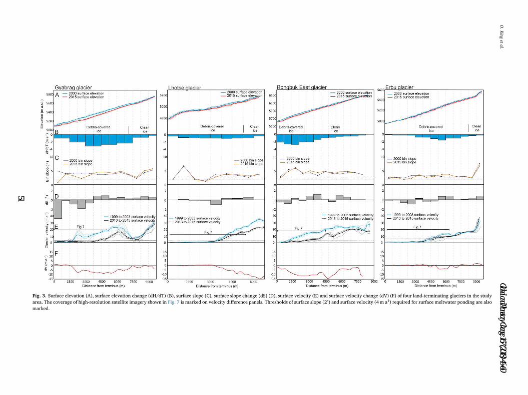
Fig. 3. Surface elevation (A), surface elevation change (dH/dT) (B), surface slope (C), surface slope change (dS) (D), surface velocity (E) and surface velocity change (dV) (F) of four land-terminating glaciers in the study
area. The coverage of high-resolution satellite imagery shown in Fig. 7 is marked on velocity difference panels. Thresholds of surface slope (2°) and surface velocity (4 m a1) required for surface meltwater ponding are also
marked.
O.Kinget
al.
Global and Planetary Change 167 (2018) 46–60
51
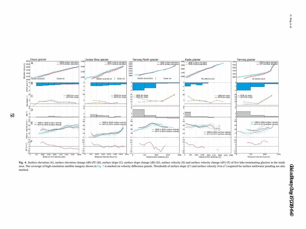
Fig. 4. Surface elevation (A), surface elevation change (dH/dT) (B), surface slope (C), surface slope change (dS) (D), surface velocity (E) and surface velocity change (dV) (F) of five lake-terminating glaciers in the study
area. The coverage of high-resolution satellite imagery shown in Fig. 7 is marked on velocity difference panels. Thresholds of surface slope (2°) and surface velocity (4 m a1) required for surface meltwater ponding are also
marked.
O.Kinget
al.
Global and Planetary Change 167 (2018) 46–60
52

Fig. 5. Surface elevation (A), surface elevation change (dH/dT) (B), surface slope (C), surface slope change (dS) (D), surface velocity (E) and surface velocity change (dV) (F) of four lake-terminating glaciers in the study
area. The coverage of high-resolution satellite imagery shown in Fig. 7 is marked on velocity difference panels. Thresholds of surface slope (2°) and surface velocity (4 m a1) required for surface meltwater ponding are also
marked.
O.Kinget
al.
Global and Planetary Change 167 (2018) 46–60
53

showed an increase in retreat rate. Mean retreat rates ranged between
−14 ± 3m a−1 (Longmojian) to −64 ± 5m a−1 (Drogpa Nagtsang)
over the study period. Hunku Glacier is unique in having sustained a
consistent ice front position between 1989 and 2015 (Fig. 6a).
Glacial lake area ranged from 0.24 ± 0.06 km2 (Hunku Glacier
lake) to 1.47 ± 0.19 km2 (Tsho Rolpa, hosted by Trakarding Glacier)
in 1989, and from 0.31 ± 0.06 km2 (Hunku Glacier lake) to
1.72 ± 0.17 km2 (Drogpa Nagtsang Glacier lake) in 2015. Glacial lake
expansion rates again varied between glaciers, with some lakes (hosted
by Drogpa Nagtsang, Lhotse Shar, Duiya and Yanong glaciers) ex-
panding at increasing rates, some lakes (hosted by Hunku, Longmojian,
Kada and Yanong glaciers) expanding at a steady rate, and one lake,
hosted by Trakarding glacier, expanding at a diminishing rate (Fig. 6d).
The change in ice front widths that occurred alongside ice front
retreat was highly variable over the study period (Table 1). The ice
front width of five of the nine lake-terminating glaciers (Duiya, Yanong,
Drogpa Nagtsang, Trakarding and Hunku glaciers) reduced by between
−7 to −93m over the study period. Ice front widening ranged from 29
to 227m on the other four (Lhotse Shar, Kada, Yanong North and
Longmojian) lake-terminating glaciers.
5. Discussion
There are clear differences in the evolving geometry and velocity of
land- and lake-terminating glaciers in the Everest region. These con-
trasts suggest that very different processes have been operating on these
glaciers of different terminus type throughout the study period.
5.1. Land-terminating glacier dynamics
The changes in the velocity and geometry of the land-terminating
glaciers we have assessed were remarkably consistent, with all nine
land-terminating glaciers experiencing similar surface geometry and
velocity adjustments over the study period (Figs. 2 and 3). The reduced
surface velocities we measured over the lower reaches of land-termi-
nating glaciers (Figs. 2 and 3) suggests a longitudinally compressional
flow regime exists here, which would have resulted in positive vertical
ice motion and therefore surface elevation increases up-glacier of
stagnant ice (Rounce et al., 2018). However, the highest thinning rates
we measured occurred in such areas proximal to stagnant ice where
Table 1
Mean ablation zone velocity change, ice front position change, glacier geometry
(surface slope) and terminal zone strain rate for lake-terminating glaciers.
Terminal strain estimates are a mean value taken over the lowermost one
kilometre of each glacier. Italicised values and glaciers are shown in Fig. 5,
whereas plain text values and glaciers are shown in Fig. 4.
Glacier Ablation
zone
velocity
change
(m a−1)
Mean ice front
position
change rate
1989–2015
(m a−1)
Mean
change in
slope
(degrees)
Terminal
strain rate
(a−1)
Ice front
width
change
(m)
Drogpa Nagtsang −1.96 −64.07a 0.04 −0.01 −14
Longmojian −8.68 −13.98 0.41 −0.05 70
Hunku −4.64 6.87 0.10 −0.01 −7
Trakarding −0.40 −21.34 0.43 −0.01 −93
Mean −3.92 −23.13 0.25 −0.02 −11
Duiya 0.18 −33.62 0.33 0.06 −54
Yanong North 2.87 −21.99 2.13 0.06 31
Lhotse Shar 0.63 −30.19 0.95 0.03 227
Kada 1.63 −29.92 1.10 0.05 29
Yanong 8.04 −46.40 2.35 0.06 −68
Mean 2.67 −32.42 1.37 0.05 33
a Drogpa Nagtsang ice front position rates measured from 1996 to 2015.
Fig. 6. A) Cumulative ice front; B) Ice front retreat rate; C) Lake area increase; and D) Lake area expansion rates for the 9 glaciers hosting lakes over the period
1989–2015.
O. King et al. Global and Planetary Change 167 (2018) 46–60
54

surface velocities declined (Figs. 2 and 3). Areas of the most substantial
velocity reductions were coincident with the clean ice- debris covered
transition zone of each land-terminating glacier, where debris thick-
nesses are commonly only a few centimetres (Nakawo et al., 1986;
Rounce et al., 2018). Under such a thin debris layer, melt rates can be
elevated above that of debris-free ice (Østrem, 1959; Nicholson and
Benn, 2006; Evatt et al., 2015), and appear to have been of a sufficient
magnitude to counter the vertical component of ice flux divergence and
resulted in substantial surface lowering. The slight increases in surface
gradient we have documented across the clean ice- debris covered
boundary on each glacier (Figs. 2 and 3) have therefore occurred be-
cause surface lowering rates are elevated above that of clean ice in this
zone of thin debris. Closer to glacier termini, the impact of both sub-
debris melt and ice flux divergence is less substantial (Rounce et al.,
2018) as debris thickness increases and ice flow is negligible, but sur-
face lowering and surface gradient reductions still occurred (Figs. 2 and
3). This is presumably because of the impact of much expanded su-
praglacial pond and ice cliff networks on land-terminating glaciers in
the area (Watson et al., 2016, 2017), which act as hot-spots of melt on
debris covered glaciers.
The reduction of surface gradients (Figs. 2 and 3) and prolonged ice
thinning on glaciers in the Everest region (cf. Bolch et al., 2011) will
have led to a reduction in driving stress (Cuffey and Paterson, 2010;
Benn et al., 2012) and therefore glacier velocities, not just over our
study period, but also during preceding decades. Figs. 2 and 3 show that
this process has clearly been in operation on the lower reaches of land-
terminating glaciers in the Everest region; large areas display little or
no flow up to several kilometres from their termini, surface gradients
are low across these stagnant areas (Figs. 2 and 3)., and the greatest
differences in surface velocity were seen on glaciers (Gyabrag and
Rongbuk) with the greatest percentage decrease in surface gradient
(Figs. 2 and 3). Thakuri et al. (2014) show a 17.1 ± 3.1% increase in
the total area of debris covered ice in the Everest Region since the
1960's, which has predominantly occurred as an up-glacier migration of
the debris covered-clean ice transition zone. The debris mantle on this
part of a debris covered glacier is thin (Rounce and McKinney, 2014),
thus surface lowering is amplified and the longitudinal surface gradient
has reduced (Figs. 2 and 3). Continued expansion of the debris cover
up-glacier could therefore also cause areas of reducing surface slope to
spread, with consequent further reductions in ice flow.
An additional process that may be contributing to glacier decel-
eration is a reduction in accumulation and therefore a reduction in ice
flux to lower elevations (e.g. Benn et al., 2012; Nuimura et al., 2011;
Heid and Kӓӓb, 2012). Increased snow line altitudes (Thakuri et al.,
2014), decreasing precipitation (Salerno et al., 2015) and reduced ac-
cumulation between 1970 and 2001 detected in an ice core on the
northern side of the orographic divide in the Everest region (Kaspari
et al., 2008) could all be taken as evidence of reduced accumulation
over our study period. However, a change in accumulation would only
immediately impact on the upper reaches of each glacier, and would
take time to propagate down to the ablation zone, where we have
documented the most substantial changes in glacier velocity and geo-
metry. Knowledge of the response time of Himalayan glaciers to per-
turbations in accumulation is currently relatively limited. Scherler et al.
(2011) estimated the response time of 286 glaciers across the Himalaya,
some of which were debris covered and some of which were devoid of
debris cover. Scherler et al. (2011) found that the neither the response
time nor the climate sensitivity of debris covered glaciers could be es-
timated using the same attributes as clean ice glaciers (e.g. Leclercq and
Oerlemans, 2012), and suggest that the impact of an insulating debris
layer on terminus retreat rates precludes their use as indicators of re-
cent climate change. Banerjee and Shankar (2013) suggested that debris
covered glaciers may exhibit a> 100 year ‘stationary period’ in re-
sponse to a warming climate and associated ELA increase, with little to
Fig. 7. Satellite imagery (Geoeye, Worldview) of the terminal areas of land-terminating glaciers we focus on in this study. Panels A-E are of glaciers that meet the
criteria required for glacial lake formation, whereas panels F-I show glaciers that do not meet these criteria.
O. King et al. Global and Planetary Change 167 (2018) 46–60
55

no terminus retreat occurring during this period. Of the nine land-ter-
minating glaciers shown in Figs. 2 and 3, eight are stationary over their
lower reaches, and have been since at least the date of our first velocity
observations (1999). Thakuri et al. (2014) also documented little
(−6.1 ± 0.2m a−1) ice front retreat over land-terminating glacier in
the Everest region over the period 1962 to 2011. However, without
more temporally extensive observations of glaciers length variations
and glacier velocity, it is difficult to suggest how long these glaciers
may have been in the stationary state suggested by Banerjee and
Shankar (2013), and how close they may be to a different mode of
response to continued warming.
5.2. Lake-terminating glacier dynamics
The velocity and geometry change data we have generated for lake-
terminating glaciers can be separated into two distinct groups (Figs. 4
and 5). The increased velocity of the five lake-terminating glaciers
shown in Fig. 4, and the associated expansion of the glacial lakes they
host (Fig. 6), suggests a link between lake expansion and glacier be-
haviour in these 5 cases. Conversely, the flow velocity deceleration of
the four lake-terminating glaciers shown in Fig. 5 suggests glacial lake
expansion may not have significantly impacted their dynamics over the
study period. These observations suggest two contrasting sets of pro-
cesses have been in operation on lake-terminating glaciers in the
Everest region over the last 15 years.
The two main components of frontal ablation on marine- and lake-
terminating glaciers are mechanical calving and the subaqueous melt of
the ice front in contact with water (Carrivick and Tweed, 2013). Either
of these melt components can be the dominant factor in ice front po-
sition retreat across different water terminating glaciers in both space
and time (Truffer and Motyka, 2016). The magnitude of subaqueous
melt depends primarily on the temperature of the proglacial water body
and its salinity. Small, proglacial lakes are typically much cooler than
water in a coastal, marine setting (Chikita, 2007; Truffer and Motyka,
2016), and there is little density contrast between glacial meltwater and
the freshwater of the proglacial water body to drive the circulation of
water and enhance subaqueous melt. Indeed, Trüssel et al. (2013) found
that on one Alaskan, lake-terminating glacier (Yakutat Glacier), the
observed thinning could be entirely explained by surface melt, and that
there was no contribution from subaqueous melt. Data on the tem-
perature and structure of the proglacial lakes in our study area are
limited. Chikita (2007) show a water temperature of 2–3 °C for much of
the water column in Imja Tsho and Tsho Rolpa with only a shallow
(~20m of a total water depth of 120m or more for both lakes) layer of
warmer water (3–6 °C) towards the surface of the lake. These tem-
peratures are similar to those of the lake at the front of Yakutat Glacier
(water temperatures of between 0.5 and 1.5 °C– Trüssel et al., 2013),
and we therefore suggest that such conditions cannot reasonably ac-
count for the mass loss rates that have been detected on these glaciers
(King et al., 2017). It is likely that the warm surface layer documented
by Chikita (2007) and wind driven water currents (Sakai et al., 2009)
would drive the development of a thermal notch as has been docu-
mented on other lake-terminating glaciers (Warren and Kirkbride,
2003; Trüssel et al., 2013), but only over a limited vertical extent. We
therefore focus the following discussion of lake-terminating glacier re-
treat on the impact of mechanical calving on these glaciers.
The acceleration of the five lake-terminating glaciers shown in Fig. 4,
and their sustained or accelerating ice front retreat rates (Fig. 6), suggests
a link between lake development and glacier behaviour in these 5 cases
over the last 15 years. Benn et al. (2007) outline three models of water-
terminating glacier behaviour, the third of which, which considers both
lateral and basal drag as the dominant resisting stress to ice flow, is most
appropriate for the topographically constrained glaciers we have as-
sessed in this study. The model of Benn et al. (2007) is applicable to
glaciers that have developed a lake of sufficient depth to interact with the
glacier at its bed. In this model, dynamic water-terminating glacier
retreat is triggered by an imposed thinning (an increase in surface melt,
for example) that alters the level of effective pressure- the difference
between ice overburden pressure and water pressure. Decreasing effec-
tive pressure causes ice flow acceleration and a positive feedback ensues
between acceleration, increased longitudinal strain, dynamic thinning
and calving retreat. Calving retreat becomes dominant because exten-
sional flow causes the deepening of crevasses in the terminal zone of each
glacier, and because thinning reduces the freeboard level (the height of
the glacier surface above lake level), increasing the likelihood that cre-
vasses will reach the waterline. The strength of this feedback differs
depending on the magnitude of resisting stresses (lateral and basal drag),
particularly where the glacier is grounded, with the maximum attainable
glacier velocity being lower where resisting stresses are high, and vice
versa. The magnitude of the feedback between these processes can also
be moderated by surface gradient (Benn et al., 2007).
We have documented the occurrence of a number of the processes
that combine to set up the positive feedback proposed by Benn et al.
(2007) to drive increased ice loss on lake-terminating glaciers. The five
lake-terminating glaciers shown in Fig. 4 have experienced substantial
terminal zone thinning (shown here and in Bolch et al., 2011; Nuimura
et al., 2012), flow acceleration (Fig. 4) and increased longitudinal strain
(Table 1), and sustained or accelerating ice front retreat rates over the
last 26 years (Fig. 6). We therefore suggest that the set of processes
incorporated into the model of Benn et al. (2007) are in operation on
some Himalayan lake-terminating glaciers, as has been inferred on lake-
terminating glaciers in other glacierised regions (Muto and Furaya,
2013; Robertson et al., 2013; Sakakibara and Sugiyama, 2014; Chernos
et al., 2016). The variability in cumulative glacier front retreat and
glacier front retreat rates we show in Fig. 6, and the broad range of
mass balance estimates generated for lake-terminating glaciers by King
et al. (2017), likely reflects the variable response of glaciers depending
on their topographic setting (i.e. valley morphology), width and surface
slope- all factors that influence levels of basal and lateral drag
(Pementel et al., 2010; Adhikari and Marshall, 2012).
The slowdown of the four lake-terminating glaciers shown in Fig. 5
suggests glacial lake expansion may not have been the dominant factor
in their evolving dynamics over our study period, despite the physical
link between each lake and its host glacier. Three of these four glaciers
(Trakarding, Hunku and Longmojian) have hosted glacial lakes since at
least the 1970's (Sakai et al., 2000; Bajracharya et al., 2007), and may
have been thinning, like other glaciers in the Everest region (Bolch
et al., 2011), over a similar timescale, including our study period (King
et al., 2017). The deceleration of these three glaciers may therefore be a
result of a reduction in driving stress and increased resistive stresses
(lateral and basal drag) as the terminal zone of these glaciers narrowed
(Table 1) in association with thinning (Pementel et al., 2010; Adhikari
and Marshall, 2012). Reduced ice flow, combined with increased re-
sistive stresses, would have reduced levels of longitudinal stretching,
transverse crevassing and therefore calving, when compared with for-
merly elevated surface velocities (Benn et al., 2012). The diminishing
ice front retreat rate of Trakarding Glacier may be evidence of this
process. The less substantial terminus proximal surface lowering on
Trakarding and Hunku glaciers over the study period likely indicates
that surface melt is now the dominant ice loss process, rather than
calving and dynamic ice front retreat.
The behaviour of Drogpa Nagtsang cannot be explained by these
same processes given the relatively recent formation of its lake (Fig. 6).
In this case, the lake that has developed may still be supraglacial, and is
therefore too shallow (or the glacier still too thick) to initiate more
dynamic glacier behaviour. Until this glacier thins, or the lake melts
through the remaining glacier ice, flow acceleration through an ad-
justment of effective pressure will not occur. The changes in glacier
velocity and geometry we have observed for this glacier (Fig. 5) are
more akin to those of a land-terminating glacier, as would be the case
on other glaciers that have recently developed lakes that are yet to
influence their dynamics.
O. King et al. Global and Planetary Change 167 (2018) 46–60
56

5.3. Preconditioning of glacier surfaces for lake development- can lake
formation be predicted?
Previous studies have suggested that under particular geometric and
dynamic conditions surface melt ponds are likely to coalesce, enabling
glacial lakes to form. Quincey et al. (2007) and Reynolds et al. (2000)
suggested that meltwater ponding and coalescence is most likely to
occur where glacier surfaces are of< 2° slope and effectively ‘stagnant’.
If a glacier surface is steeper than this threshold or flowing actively,
meltwater will continue to drain down-glacier, or crevasse formation
(from active flow) will provide pathways for englacial meltwater re-
routing, most likely towards the edge of a glacier, where lateral drag
causes enhanced strain and ice surface fracturing (Cuffey and Paterson,
2010). Using the criteria of Quincey et al. (2007) and Reynolds et al.
(2000) we are able to assess whether any of the land-terminating gla-
ciers we have examined are primed for glacial lake development.
Fig. 7 shows the terminal regions of the nine land-terminating gla-
ciers depicted in Figs. 2 and 3. Of these glaciers, five (those in Fig. 2)
show substantial supraglacial pond formation (water bodies of<
20,000m2 area), or, in the case of Rongbuk Glacier, supraglacial lake
formation (Watson et al., 2016). These glaciers showed large areas
of< 2° slope and negligible ice flow in the first epoch of our DEM and
velocity time series, and an expanded area of the same conditions at the
end of our study period. Watson et al. (2016) documented substantial
increases in the ponded area of some of these glaciers over our study
period, as did Chen et al. (2014) for the supraglacial lake on Rongbuk
Glacier, so it is likely that these glaciers are already in the early stages
of glacial lake development. Continued sub-debris melt in the middle
reaches of these glaciers would further decrease the surface gradient
and provide meltwater, both aiding supraglacial pond and lake ex-
pansion.
Four of the nine land-terminating glaciers we studied (shown in
Fig. 3) fail to meet one or both of the criteria proposed by Quincey et al.
(2007) and Reynolds et al. (2000) (Fig. 7), and have not experienced
pond coalescence. Gyabrag Glacier (Fig. 7 panel G) showed surface
gradient values greater than the 2° threshold (mean of 4.03°) required
for effective meltwater ponding. Rongbuk East (Fig. 7 panel F) showed
substantial ice flow to its terminus (Fig. 3c), as well as being too steep
(mean 4.15°) for water to collect. Small areas of Lhotse and Erbu gla-
ciers meet the velocity and surface gradient thresholds (Figs. 3b & d),
and some ponding is evident on these glaciers (Fig. 7, panels H & I).
Lhotse and Erbu glaciers may therefore be in the early stages of pond
coalescence, and further surface lowering will aid water ponding here.
Collectively, these observations suggest the criteria outlined by Quincey
et al. (2007) and Reynolds et al. (2000) are appropriate as a first-pass
method to identify glaciers that may or may not be susceptible to glacial
lake formation.
5.4. Implications of lake-terminating glacier retreat
We have shown here how different ice mass loss processes may
drive the evolution of lake and land-terminating glaciers in the
Himalaya. Lake-terminating glaciers experience different phases of re-
treat and ice loss as the lake they host expands. Initially, a phase of lake
expansion may occur that is not accompanied by amplified glacier mass
loss. As the lake level rise or the host glacier thins, calving can occur,
front retreat rates may accelerate, the glacier surface profile steepens,
and ice flow rates increase. Towards the later stages of lake growth,
after a sustained period of ice front retreat and glacier thinning, which
reduce driving stresses and increase resisting stresses (lateral and basal
drag) due to glacier narrowing (e.g. Adhikari and Marshall, 2012), lake-
terminating glaciers slowdown and their retreat rate diminishes. As the
total number of glacial lakes seems to be increasing, not just in the
Everest Region, but across the Himalaya (Zhang et al., 2015; Nie et al.,
2017), it can be inferred that glacial lake expansion will serve to am-
plify the future mass loss of their host glaciers. Similar observations of
amplified ice loss from lake terminating glaciers have been made
elsewhere in the Himalaya. For example, Basnet et al. (2013) examined
the area loss of 38 glaciers in the Sikkim Himalaya, India, from 1990 to
2014, and found that the total area loss of the 23 lake-terminating
glaciers in their sample was five times greater than the total area loss of
land terminating glaciers. Wang et al. (2017) observed similarly am-
plified retreat rates of lake terminating glaciers (six times higher) when
compared with land terminating glaciers in the Hengduan Shan region
of the southeastern Tibetan Plateau from 1990 to 2014.
It is unclear how long it takes for lake growth to initiate more dy-
namic glacier behaviour. The development of the large (1.38 km2) su-
praglacial lake on Drogpa Nagtsang Glacier has been rapid (Fig. 6), but
there is no evidence for a resulting effect on the glacier velocity or
geometry. Similarly, Rongbuk Glacier has developed a large (0.48 km2)
supraglacial lake since the early 1990s (Chen et al., 2014), but the
glacier is stagnant over the area the lake occupies, and the gradient of
its lower reaches has reduced as the lake has persisted. Without detailed
ice thickness and multi-temporal lake bathymetry datasets, which are
both sparse in the Everest region and across the Himalaya as a whole,
predictions of when supraglacial lake growth may impact ice dynamics
are obviously difficult to make, and may be glacier specific, depending
on deepening rates of individual lakes.
Once a full-depth lake has developed and has begun to impact on
glacier velocities and thinning rates, the duration of amplified ice mass
loss will depend on the spatial extent of enhanced thinning and the
magnitude of acceleration. This study has shown that substantial glacier
length reductions could occur over a few decades. Although the front
retreat rates we show (Fig. 6) may seem moderate, the cumulative total
front retreat on the nine lake-terminating glaciers in our sample ac-
counted for an average glacier length reduction of almost 20% (ranging
from 11 to 41%) over 25 years. Throughout this period of ice front
retreat, surface lowering rates over the terminal regions of lake-termi-
nating glaciers may be more than double those of neighbouring land-
terminating glaciers (King et al., 2017), and this impacts on the mass
balance of each lake-terminating glacier (Bolch et al., 2011; King et al.,
2017). The scale of ice loss is also likely to be large on Himalayan
glaciers that have especially low surface gradients, as the presence of a
glacial lake pins the glacier terminus to a certain altitude and precludes
the stabilising feedback of the glacier retreating to a higher altitude
(Truffer and Motyka, 2016). Glaciers with long ablation zones of a si-
milar altitude, such as those shown in Fig. 2, will therefore have to
retreat substantially up-valley before they can separate vertically from
their glacial lake.
The expansion of a glacial lake heightens GLOF hazard directly
because; 1) glacial lake expansion increases the area into which mass
movements (from both the host glacier and surrounding terrain) can
enter and form an overtopping wave, and 2) an increase in lake volume
increases lake depth and hence the water burden pressure on the
terminal moraine dam. An increase in the calving flux or frequency of
large calving events may also lead to more frequent wave or over-
topping events (Fujita et al., 2013; Westoby et al., 2014). Gardelle et al.
(2011) documented a 20% increase in the area of glacial lakes in the
Everest region over the period 2000–2009, and our ice front position
data shows that this trend has continued through to 2015. Rounce et al.
(2017) modelled potential lake expansion and mass-movement trajec-
tories in the Everest region and showed that Imja Tsho could become
more hazardous as the lake becomes more proximal to avalanche prone
terrain up-valley. The same scenario can be envisaged for other glacial
lakes, particularly those that have formed on glaciers fed by steep
headwalls and whose primary source of accumulation if from ava-
lanches, as is common in the Himalaya (Benn et al., 2001; Itturizaga,
2011).
5.5. Outlook
A number of recent modelling studies (e.g. Rowan et al., 2015; Shea
O. King et al. Global and Planetary Change 167 (2018) 46–60
57
et al., 2015; Anderson and Anderson, 2016) have successfully replicated
the changes in geometry and velocity of Himalayan land-terminating
glaciers in a state of negative mass balance that we describe above.
However, the complete contrast in the evolution of lake-terminating
glaciers demands a modified approach be taken to simulate their be-
haviour under different climate scenarios. The similarity of the velocity
and thinning regimes predicted by the modelling work of studies such
as Benn et al. (2007) with the data we present here suggests that many
elements of lake-terminating glacier behaviour in the Himalaya can be
predicted. The calculation of the time taken for a full depth lake to form
and the accommodation space available for a glacial lake is currently
limited by a paucity of well-constrained glacier bed topography and ice
thickness data, both of which may be suitable foci for future work in the
region. Where a glacier is already hosting a glacial lake, measurements
of lake bathymetry (e.g. Yamada, 1998; Somos-Valenzuela et al., 2014)
are important as, alongside the down-glacier velocity gradient, the
difference between ice thickness and water depth is considered a pri-
mary control on lake-terminating glacier terminus position (Benn et al.,
2007). Detailed measurements of glacial lake depth are currently only
available for Imja Tsho in our study area. Comparison of the bathy-
metric surveys presented by Chikita (2007), Fujita et al. (2009) and
Somos-Valenzuela et al. (2014) suggests up to 30m of deepening in this
lake between 1996/1997 and 2012, which may have been a large
contributing factor in the dynamic changes of its host glacier (Lhotse
Shar Glacier) that we have shown.
6. Conclusions
Analysis of a time series of DEMs and glacier surface velocity data
has revealed contrasting geometric and dynamic evolution of lake- and
land-terminating glaciers in the Everest region of the Central Himalaya
over the last 15 years. Land-terminating glaciers showed similar thin-
ning patterns, changes in surface gradient and changes in velocity.
These glaciers thinned most close to the debris-clean ice transition zone,
became shallower over their lower reaches and decelerated over the
study period. Lake-terminating glacier behaviour can be characterised
by two distinct groups. Five of the nine lake-terminating glaciers we
assessed showed increased surface velocities alongside enhanced
terminal thinning and increased surface gradients. These five glaciers
show steady or increasing ice front retreat rates. The remaining four
lake-terminating glaciers showed low magnitude glacier surface stee-
pening, reduced glacier surface velocities and steady or diminishing ice
front retreat rates. We suggest that this contrasting lake-terminating
glacier behaviour represents two different phases of glacier-lake inter-
action; one where a dynamic link exists between lake expansion and
glacier mass loss, with a positive feedback operating between de-
creasing effective pressure, increased ice velocities, enhanced thinning
and longitudinal strain, enhancing mass loss. The other is re-
presentative of either an early phase of lake development, during which
a glacial lake does not substantially impact on its host glaciers dy-
namics, or a late stage where a glacier begins to disconnect from the
lake it hosts. During either of these stages, changes in glacier velocity or
geometry will be more akin to those of a land-terminating glacier.
The timeline of lake development and coincident glacier retreat
remains uncertain, but we have documented substantial ice front re-
treat over a few decades in the Everest region of the central Himalaya.
An improved understanding of the bed topography and ice thickness of
glaciers primed for lake development would undoubtedly aid efforts to
model future lake-terminating glacier behaviour. In their absence,
glacier geometry and glacier velocity data can at least be used as a first-
pass tool to identify glaciers that are preconditioned for lake develop-
ment. These data may serve as early warning for those living and
working in the region who may need to adapt to an increasing hazard
over coming decades, but additionally, they may also be used by nu-
merical modellers aiming to simulate glacier evolution under varying
climatic scenarios, as the need to consider glacier-lake interactions
becomes increasingly pertinent.
Supplementary data to this article can be found online at https://
doi.org/10.1016/j.gloplacha.2018.05.006.
Acknowledgements
OK is a recipient of a NERC SPHERES DTP PhD Studentship (grant
award NE/L002574/1). AD was supported by funding from the NASA
Cryosphere Program. The research was conducted at the Jet Propulsion
Laboratory, California Institute of Technology under contract with the
National Aeronautics and Space Agency.
Supplementary data
References
Adhikari, S., Marshall, S.J., 2012. Parameterization of lateral drag in flowline models of
glacier dynamics. J. Glaciol. 58 (212), 1119–1132. http://dx.doi.org/10.3189/
2012JoGG12J018.
Anderson, L.S., Anderson, R., 2016. Modeling debris-covered glaciers: response to steady
debris deposition. Cryosphere 10, 1105–1124. http://dx.doi.org/10.5194/tc-10-
1105-2016.
Bajracharya, S.R., Mool, P.K., Shrestha, B.R., 2007. Impact of Climate Change on
Himalayan Glaciers and Glacial Lakes: Case Studies on GLOF and Associated Hazards
in Nepal and Bhutan. International Centre for Integrated Mountain Development
(ICIMOD), Kathmandu.
Bajracharya, Samjwal, Shrestha, Finu, Bajracharya, Samjwal, Maharjan, S.B., Guo,
Wanqin, 2014. GLIMS Glacier Database. National Snow and Ice Data Center, Boulder,
CO. http://dx.doi.org/10.7265/N5V98602.
Banerjee, A., Shankar, R., 2013. On the response of Himalayan glaciers to climate change.
J. Glaciol. 59 (215), 480–490. http://dx.doi.org/10.3189/2013JoG12J130.
Basnet, S., Kulkarni, A.V., Bolch, T., 2013. The influence of debris cover and glacial lakes
on the recession of glaciers in Sikkim Himalaya, India. J. Glaciol. 59 (218). http://dx.
doi.org/10.3189/2013JoG12J184.
Benn, D.I., Wiseman, S., Hands, K.A., 2001. Growth and drainage of supraglacial lakes on
debris-mantled Ngozumpa Glacier, Khumbu Himal, Nepal. J. Glaciol. 47 (159),
626–638. http://dx.doi.org/10.3189/172756501781831729.
Benn, D.I., Hulton, N.R.J., Mottram, R.H., 2007. ‘Calving laws’, ‘sliding laws’ and the
stability of tidewater glaciers. Ann. Glaciol. 46. http://dx.doi.org/10.3189/
172756407782871161.
Benn, D.I., Bolch, T., Hands, K., Gulley, J., Luckman, A., Nicholson, L.I., Quincey, D.,
Thompson, S., Toumi, R., Wiseman, S., 2012. Response of debris-covered glaciers in
the Mount Everest region to recent warming, and implications for outburst flood
hazards. Earth Sci. Rev. (114), 156–174. http://dx.doi.org/10.1016/j.earscirev.2012.
03.008.
Bolch, T., Pieczonka, T., Benn, D.I., 2011. Multi-decadal mass loss of glaciers in the
Everest area (Nepal Himalaya) derived from stereo imagery. Cryosphere (5),
349–358. http://dx.doi.org/10.5194/tc-5-349-2011.
Braithwaite, R.J., Raper, S.C.B., 2009. Estimating equilibrium-line altitude (ELA) from
glacier inventory data. Ann. Glaciol. (50), 127–132. http://dx.doi.org/10.3189/
172756410790595930.
Burgess, E., Forster, R.E., Larsen, C.F., 2013. Flow velocities of Alaskan glaciers. Nat.
Commun. 4, 2146. http://dx.doi.org/10.1038/ncomms3146.
Carrivick, J.L., Tweed, F.S., 2013. Proglacial lakes: character, behaviour and geological
importance. Quat. Sci. Rev. (78), 34–52. http://dx.doi.org/10.1016/j.quascirev.
2013.07.028.
Carrivick, J.L., Tweed, F.S., 2016. A global assessment of the societal impacts of glacier
outburst floods. Glob. Planet. Chang. (144), 1–16. http://dx.doi.org/10.1016/j.
gloplacha.2016.07.001.
Chen, W., Doko, T., Liu, C., Ichinose, T., Fukui, H., Feng, Q., Gou, P., 2014. Changes in
Rongbuk Lake and Imja lake in the Everest Region of Himalaya, The International
Archives of the Photogrammetry, Remote Sensing and Spatial Information Sciences,
Volume XL-2, ISPRS Technical Commission II Symposium. http://dx.doi.org/10.
5194/isprsarchives-XL-2-259-2014.
Chernos, M., Koppes, M., Moore, R.D., 2016. Ablation from calving and surface melt at
lake-terminating Bridge Glacier, British Columbia, 1984–2013. Cryosphere 10,
87–102. http://dx.doi.org/10.5194/tc-10-87-2016.
Chikita, K.A., 2007. Topographic effects on the thermal structure of Himalayan glacial
lakes: observations and numerical simulation of wind. J. Asian Earth Sci. (30),
344–352. http://dx.doi.org/10.1016/jseas.2006.10.005.
Cuffey, K.H., Paterson, W.S.B., 2010. The Physics of Glaciers, 4th ed. Elsevier, Burlington.
Dehecq, A., Gourmelen, N., Trouve, E., 2015. Deriving large-scale glacier velocities from a
complete satellite archive: application to the Pamir-Karakoram-Himalaya. Remote
Sens. Environ. 162, 55–66. http://dx.doi.org/10.1016/j.rse.2015.01.031.
Evatt, G., Abrahams, I., Heil, M., Mayer, C., Kingslake, J., Mitchell, S., Fowler, A.C., Clark,
C., 2015. Glacial melt under a porous debris layer. J. Glaciol. 61 (229), 825–836.
http://dx.doi.org/10.3189/2015JoG14J235.
Fitch, A.J., Kadyrov, A., Christmas, W.J., Kitller, J., 2002. Orientation correlation. In:
Proceedings of the British Machine Conference. BMVA Press pp.11.1–11.10. https://
doi.org/10.5244/C.16.11.
Fujita, K., Sakai, A., Nuimura, T., Yamaguchi, S., Sharma, R.R., 2009. Recent changes in
Imja Glacial Lake and its damming moraine in the Nepal Himalaya revealed by in situ
O. King et al. Global and Planetary Change 167 (2018) 46–60
58

surveys and multi-temporal ASTER imagery. Environ. Res. Lett. (4), 1–7. http://dx.
doi.org/10.1088/1748-9326/4/4/045205.
Fujita, K., Sakai, A., Takenaka, S., Nuimura, T., Surazakov, A.B., Sawagaki, T.,
Yamanokuchi, T., 2013. Potential flood volume of Himalayan glacial lakes. Nat.
Hazards Earth Syst. Sci. 13 (7), 1827–1839. http://dx.doi.org/10.5194/nhess-13-
1827-2013.
Gardelle, J., Arnaud, Y., Berthier, E., 2011. Contrasted evolution of glacial lakes along the
Hindu Kush Himalaya mountain range between 1990 and 2009. Glob. Planet. Chang.
(75), 47–55. http://dx.doi.org/10.1016/j.gloplacha.2010.10.003.
Heid, T., Kӓӓb, A., 2012. Repeat optical satellite images reveal widespread and long term
decrease in land-terminating glacier speeds. Cryosphere (6), 467–478. http://dx.doi.
org/10.5194/tc-6-467-2012.
International Centre for Integrated Mountain Development (ICIMOD), 2011. Glacial
Lakes and Glacial Lake Outburst Floods in Nepal. ICIMOD, Kathmandu, Nepal.
Itturizaga, L., 2011. Trends in 20th century and recent glaciers fluctuations in the
Karakoram Mountains. Z. Geomorphol. (55), 205–231. http://dx.doi.org/10.1127/
0372-8854/2011/0055S3-0059.
Kaspari, S., Hooke, R., Le, B., Mayewski, P.A., Kang, S.C., Hou, S.G., Qin, D.H., 2008.
Snow accumulation rate on Qomolangma (Mount Everest), Himalaya: synchroneity
with sites across the Tibetan Plateau on 50-100 year timescales. J. Glaciol. 54 (185),
343–352. http://dx.doi.org/10.3189/002214308784886126.
Kääb, A., Berthier, E., Nuth, C., Gardelle, J., Arnaud, Y., 2012. Contrasting patterns of
early 21st century glacier mass change in the Himalayas. Nature 488, 495–498.
http://dx.doi.org/10.1038/nature11324.
King, O., Quincey, D.J., Carrivick, J.L., Rowan, A.V., 2017. Spatial variability in mass loss
of glaciers in the Everest region, central Himalayas, between 2000 and 2015.
Cryosphere (11), 407–426. http://dx.doi.org/10.5194/tc-11-407-2017.
Leclercq, P.W., Oerlemans, 2012. Global and hemispheric temperature reconstruction
from glacier length fluctuations. J. Clim Dyn 38. http://dx.doi.org/10.1007/s00382-
011-1145-7.
McNabb, R.W., Hock, R., 2014. Alaska tidewater glacier terminus positions, 1948–2012.
J. Geophys. Res. Earth Surf. (119), 153–167. http://dx.doi.org/10.1002/
2013JF002915.
Melkonian, A., Willis, M.K., Pritchard, M.E., 2016. Stikine icefield mass loss between
2000 and 2013/2014. Front. Earth Sci. 4 (89). http://dx.doi.org/10.3389/feart.2016.
0089.
Miles, E.S., Willis, I.C., Arnold, N.S., Steiner, J., Pellicciotti, F., 2016. Spatial, seasonal and
interannual variability of supraglacial ponds in the Langtang Valley, 1999–2013. J.
Glaciol. 63 (237), 88–105. http://dx.doi.org/10.1017/jog.2016.120.
Moon, T., Joughin, I., 2008. Changes in ice front position on Greenland's outlet glaciers
from 1992 to 2007. J. Geophys. Res.(113), F02022. http://dx.doi.org/10.1029/
2007JF000927.
Muto, M., Furaya, M., 2013. Surface velocities and ice-front positions of eight major
glaciers in the Southern Patagonian Ice Field, South America, from 2002 to 2011.
Remote Sens. Environ. 139. http://dx.doi.org/10.1016/j.rse.2013.07.034.
Nakawo, M., Iwata, S., Watanabe, O., Yoshida, M., 1986. Processes which distribute su-
praglacial debris on the Khumbu Glacier, Nepal Himalaya. Ann. Glaciol. 8, 129–131.
Nakawo, M., Yabuki, H., Sakai, A., 1999. Characteristics of Khumbu Glacier, Nepal
Himalaya: recent change in the debris-covered area. Ann. Glaciol. 28, 118–122.
http://dx.doi.org/10.3189/172756499781821788.
Nicholson, L., Benn, D., 2006. Calculating ice melt beneath a debris layer using me-
teorological data. J. Glaciol 52 (178), 463–470. http://dx.doi.org/10.3189/
172756506781828584.
Nie, Y., Sheng, Y., Liu, Q., Liu, L., Liu, S., Zhang, Y., Song, C., 2017. A regional-scale
assessment of Himalayan glacial lake changes using satellite observations from
1990–2015. Remote Sens. Environ. 189, 1–13. http://dx.doi.org/10.1016/j.rse.2016.
11.008.
Noh, M.J., Howat, I.M., 2015. Automated stereo-photogrammetric DEM generation at
high latitudes: Surface Extraction with TIN-based Search-space Minimization
(SETSM) validation and demonstration over glaciated regions. Remote Sens. (52),
198–217. http://dx.doi.org/10.1080/15481603.2015.1008621.
Nuimura, T., Fujita, K., Fukui, K., Asahi, K., Aryal, R., Ageta, Y., 2011. Temporal changes
in elevation of the debris-covered ablation area of Khumbu Glacier in the Nepal
Himalaya since 1978. Arct. Antarct. Alp. Res. 43 (2), 246–255. http://dx.doi.org/10.
1657/1938-4246-43.2.246.
Nuimura, T., Fujita, K., Yamaguchi, S., Sharma, R.R., 2012. Elevation changes of glaciers
revealed by multitemporal digital elevation models calibrated by GPS survey in the
Khumbu region, Nepal Himalaya, 1992–2008. J. Glaciol. 58 (210), 648–656. http://
dx.doi.org/10.3189/2012JoG11J061.
Nuth, C., Kääb, A., 2011. Co-registration and bias corrections of satellite elevation data
sets for quantifying glacier thickness change. Cryosphere (5), 271–290. http://dx.doi.
org/10.5194/tc-5-271-2011.
Østrem, G., 1959. Ice melting under a thin layer of moraine, and the existence of ice cores
in moraine ridges. Geogr. Ann. (41), 228–230. http://dx.doi.org/10.1080/20014422.
1959.11907953.
Paul, F., Winsvold, S.H., Kääb, A., Nagler, T., Schwaizer, G., 2016. Glacier remote sensing
using Sentinel-2. Part II: mapping glacier extents and surface facies, and comparison
to Landsat 8. Remote Sens. 8 (7), 575. http://dx.doi.org/10.3390/rs8070575.
Pementel, S., Flowers, G.E., Schoof, C.G., 2010. A hydrologically coupled higher-order
flow-band model of ice dynamics with a Coulomb friction sliding law. J. Geophys.
Res. 115. http://dx.doi.org/10.1029/2009JF001621.
Quincey, D.J., Richardson, S.D., Luckman, A., Lucas, R.M., Reynolds, J.M., Hambrey,
M.J., Glasser, N.F., 2007. Early recognition of glacial lake hazards in the Himalaya
using remote sensing datasets. Glob. Planet. Chang. (56), 137–152. http://dx.doi.
org/10.1016/j.gloplacha.2006.07.013.
Reynolds, J.M., Nakawo, M., Raymond, C.F., Fountain, A., 2000. On the formation of
supraglacial lakes on debris-covered glaciers. In: Debris-Covered Glaciers.
Proceedings of a Workshop held at Seatlle, Washington, U.S.A., September 2000,
Oxford. vol. 264. IAHS Publication, pp. 153–4161.
Rignot, E., Echelmeyer, K., Krabill, W., 2001. Penetration depth of interferometric syn-
thetic-aperture radar signals in snow and ice. Geophys. Res. Lett. (28), 3501–3504.
http://dx.doi.org/10.1029/2000GL012484.
Robertson, C.M., Brook, M.S., Holt, K.A., Fuller, I., Benn, D.I., 2013. Calving retreat and
proglacial lake growth at Hooker Glacier, Southern Alps, New Zealand. N. Z. Geogr.
(69), 14–25. http://dx.doi.org/10.1111/nzg.12001.
Rounce, D.R., McKinney, D.C., 2014. Debris thickness of glaciers in the Everest area
(Nepal Himalaya) derived from satellite imagery using a nonlinear energy balance
model. Cryosphere (8), 1317–1329. http://dx.doi.org/10.5194/tc-8-1317-2014.
Rounce, D.R., Watson, C.S., McKinney, D.C., 2017. Identification of hazard and risk for
glacial lakes in Nepal Himalaya using satellite imagery from 2000–2015. Remote
Sens. 9 (654). http://dx.doi.org/10.3390/rs9070654.
Rounce, D.R., King, O., McCarthy, M., Shean, D.E., Salerno, F., 2018. Quantifying debris
thickness of debris-covered glaciers in the Everest region of Nepal through inversion
of a sub-debris melt model. J. Geophys. Res. 123. http://dx.doi.org/10.1029/
2017JF004395.
Rowan, A.V., Egholm, D.L., Quincey, D.J., Glasser, N.F., 2015. Modelling the feedbacks
between mass balance, ice flow and debris transport to predict the response to cli-
mate change of debris-covered glaciers in the Himalaya. Earth Planet. Sci. Lett. 430,
427–438. http://dx.doi.org/10.1016/j.epsl.2015.09.004.
Sakai, A., Chikita, K., Yamada, T., 2000. Expansion of a moraine-dammed glacial lake,
Tsho Rolpa, in Rolwaling Himal. Nepal Himalaya. Limnology and Oceanography 45,
1401–1408.
Sakai, A., Fujita, K., 2010. Formation conditions of supraglacial lakes on debris-covered
glaciers in the Himalayas. J. Glaciol. 56 (195), 177–181. http://dx.doi.org/10.3189/
002214310791190785.
Sakai, A., Nishimura, K., Kadota, T., Takeuchi, N., 2009. Onset of calving at supraglacial
lakes on debris covered glaciers of the Nepal Himalayas. J. Glaciol. 55 (193),
909–917. http://dx.doi.org/10.3189/002214309790152555.
Sakai, A., Nuimura, T., Fujita, K., Takenaka, S., Nagai, H., Lamsal, D., 2015. Climate
regime of Asian glaciers revealed by GAMDAM Glacier Inventory. Cryosphere 9 (3),
865–880. http://dx.doi.org/10.5194/tc-9-865-2015.
Sakakibara, D., Sugiyama, S., 2014. Ice-front variations and speed changes of calving
glaciers in the Southern Patagonia Icefield from 1984 to 2011. J. Geophys. Res. Earth
Surf. 119, 2541–2554. http://dx.doi.org/10.1002/2014JF003148.
Salerno, F., Guyennon, N., Thakuri, S., Viviano, G., Romano, E., Vuillermoz, E.,
Cristofanelli, P., Stocchi, P., Agrillo, G., Ma, Y., Tartari, G., 2015. Weak precipitation,
warm winters and springs impact glaciers of south slopes of Mt. Everest (central
Himalaya) in the last 2 decades (1994–2013). In: The Cryosphere. vol. 9. pp.
1229–1247. http://dx.doi.org/10.5194/tc-9-1229-2015.
Scherler, D., Bookhagen, B., Strecker, M.R., 2011. Spatially variable response of
Himalayan glaciers to climate change affected by debris cover. Nat. Geosci. 4,
156–159. http://dx.doi.org/10.1038/ngeo1068.
Shea, J.M., Immerzeel, W.W., Wagnon, P., Vincent, C., Bajracharya, S., 2015. Modelling
glacier change in the Everest region, Nepal Himalaya. Cryosphere 9, 1105–1128.
http://dx.doi.org/10.5194/tc-9-1105-2015.
Somos-Valenzuela, M.A., Mckinney, D.C., Rounce, D.R., Byers, A.C., 2014. Changes in
Imja Tsho in the Mount Everest region of Nepal. Cryosphere (8), 1661–1671. http://
dx.doi.org/10.5194/tc-8-1661-2014.
Thakuri, S., Salerno, F., Smiraglia, C., Bolch, T., D'Agata, C., Viviano, G., Tartari, G., 2014.
Tracing glacier changes since the 1960s on the south slope of Mt. Everest (central
Southern Himalaya) using optical satellite imagery. Cryosphere (8), 1297–1315.
http://dx.doi.org/10.5194/tc-8-1297-2014.
Thakuri, A., Salerno, F., Bolch, T., Guyennon, N., Tartari, G., 2016. Factors controlling the
accelerated expansion of Imja Lake, Mount Everest region, Nepal. Ann. Glaciol. 57
(71). http://dx.doi.org/10.3189/2016AoG71A063.
Truffer, M., Motyka, R.J., 2016. Where glaciers meet water: subaqueous melt and its
relevance to glaciers in various settings. Rev. Geophys. (54), 220–239. http://dx.doi.
org/10.1002/2015RG000494.
Trüssel, B., Motyka, R.J., Truffer, M., Larsen, C.F., 2013. Rapid thinning of lake-calving
Yakutat Glacier and the collapse of the Yakutat Icefield, southeast Alaska, USA. J.
Glaciol. 59 (213). http://dx.doi.org/10.3189/2013J0G12J081.
Tsutaki, S., Sugiyama, S., Sakakibara, D., Sawagaki, T., 2016. Surface elevation changes
during 2007–13 on Bowdoin and Tugto Glaciers, northwestern Greenland. J. Glaciol.
62 (236), 1083–1092. http://dx.doi.org/10.1017/jog.2016.106.
Wang, X., Chai, K.G., Liu, S.Y., Wei, J., Jiang, Z., Liu, Q., 2017. Changes of glaciers and
glacial lakes implying corridor-barrier effects and climate change in the Hengduan
Shan, southeastern Tibetan Plateau. J. Glaciol. 63 (239), 1–8. http://dx.doi.org/10.
1017/jog.2017.14.
Warren, C.R., Kirkbride, M.P., 2003. Calving speed and climatic sensitivity of New
Zealand lake-calving glaciers. Ann. Glaciol. (36), 173–178. http://dx.doi.org/10.
3189/172756403781816446.
Watson, C.S., Quincey, D.J., Carrivick, J.L., Smith, M.W., 2016. The dynamics of su-
praglacial ponds in the Everest region, central Himalaya. Glob. Planet. Chang. (142),
14–27. http://dx.doi.org/10.1016/j.gloplacha.2016.04.008.
Watson, C.S., Quincey, D.J., Carrivick, J.L., Smith, M.W., 2017. Ice cliff dynamics in the
Everest region of the central Himalaya. Geomorphology 278, 238–251. http://dx.doi.
org/10.106/j.geomorph.2016.11.017.
Westoby, M.J., Glasser, N.F., Hambrey, M.J., Brasington, J., Reynolds, J.M., Hassan,
M.A.A.M., 2014. Reconstructing historic Glacial Lake Outburst Floods through nu-
merical modelling and geomorphological assessment: Extreme events in the
Himalaya. In: Earth Surface Processes and Landforms. vol. 39. pp. 1675–1692.
http://dx.doi.org/10.1002/esp.3617.
O. King et al. Global and Planetary Change 167 (2018) 46–60
59

Willis, M.J., Melkonian, A.K., Pritchard, M.E., Ramage, J.M., 2012. Ice loss rates at the
Northern Patagonian Icefield derived using a decade of satellite remote sensing.
Remote Sens. Environ. 117. http://dx.doi.org/10.1016/j.rse.2011.09.017.
Yamada, T., 1998. Glacier lake and its outburst flood in the Nepal Himalaya, Monograph
No. 1, Data Center for Glacier Research. Japanese Society of Snow and Ice, Tokyo,
pp. 96.
Yang, X., Zhang, T., Qin, D., Kang, S., Qin, X., 2011. Characteristics and changes in air
temperature and Glacier's response on the north slope of Mt. Qomolangma (Mt.
Everest). Arctic Antarctic Alpine Res. 43, 147–160. stable/41240408.
Ye, Q., Kang, S., Chen, F., Wang, J., 2006. Monitoring glacier variations on Geladandong
mountain, central Tibetan Plateau, from 1969 to 2002 using remote-sensing and GIS
technologies. J. Glaciol. 179. http://dx.doi.org/10.3189/17275650678182839.
Zhang, G., Yao, T., Xie, H., Wang, W., Yang, W., 2015. An inventory of glacial lakes in the
Third Pole region and their changes in response to global warming. Glob. Planet.
Chang. (131), 148–157. http://dx.doi.org/10.1016/j.gloplacha.2015.05.013.
O. King et al. Global and Planetary Change 167 (2018) 46–60
60