convective snow banding over north central montana€¦ · convective snow banding over north...
TRANSCRIPT

Convective Snow Banding over North Central Montana
Robert Hoenisch National Weather Service, Great Falls, Montana
ABSTRACT
This study identifies the necessary ingredients for banded convective snow over portions
of Montana east of the Continental Divide, which is derived from examples of similar events over western Montana. Two banded convective snow events are analyzed to demonstrate the occurrence of these features over central Montana as well as the need for further research and documentation of banded convective snow events.
1. Introduction
Convective precipitation features over complex terrain frequently develop as quasi-stationary bands oriented parallel to the mean flow. These bands form in the updrafts of roll-like convective circulations and may produce large precipitation enhancements over localized areas. An observational and modeling study of banded orographic precipitation over the Oregon Cascades by Kirshbaum and Durran (2005a) found that favorable conditions for flow-parallel rainbands include weak moist instability (or potential instability) and a wind profile that is nearly unidirectional through the depth of the cloudy layer. In numerical simulations, Kirshbaum and Durran (2005a) demonstrated that bands that formed in the presence of small-scale topographic irregularities were better organized and steadier than those forced only by thermal perturbations, which led to increases in localized precipitation. Numerical simulations by Kirshbaum and Durran (2005a) additionally found that the most organized convective bands and enhanced local precipitation occurred when a stationary band was triggered to the lee of an isolated peak positioned within a larger scale ridge system.
Banded convective precipitation is common to areas west of the
Continental Divide during the cold season, in cold advection situations and usually within a postfrontal environment (Petrescu 2003). These convective bands can persist for several hours over the same location, producing locally heavy snow amounts with significant snowfall rates. Petrescu (2003) suggests that banded snow events west of the Continental Divide typically produce accumulations of 2 to 5 inches. However, Johnson and Petrescu (2005) have documented snow amounts in excess of 8 inches with snowfall rates in excess of 3 inches per hour. Snow accumulation is usually very localized with little or no snow accumulation over areas adjacent to the banding. ____________________ Corresponding author address: Robert Hoenisch, National Weather Service Great Falls Forecast Office, 5324 Tri-Hill Frontage Rd, Great Falls, MT 59404. E-mail: [email protected]
Banded convective precipitation is less common over portions of Montana
east of the Continental Divide as the topography promotes downslope drying when the mean flow is from the south through west-northwest (Fig. 1). However, under certain conditions, organized convective bands can develop over the higher terrain of western Montana and persist further east onto the plains. Two such events occurred in December 2007. These events appear to be of lesser magnitude than banded snow events west of the Continental Divide, however further investigation and cataloguing of future events is needed.
The December 2007 cases were unique in that they were detectable from
satellite images a day or two after the events occurred. Typically, during the winter months, there is some snow cover on the ground to the lee of the Continental Divide, so the snow from bands would be difficult to discern. In these cases, however, there was little or no snow on the ground before the events, which caused these cases to clearly stand out.
The December 2007 banded snow events that occurred east of the
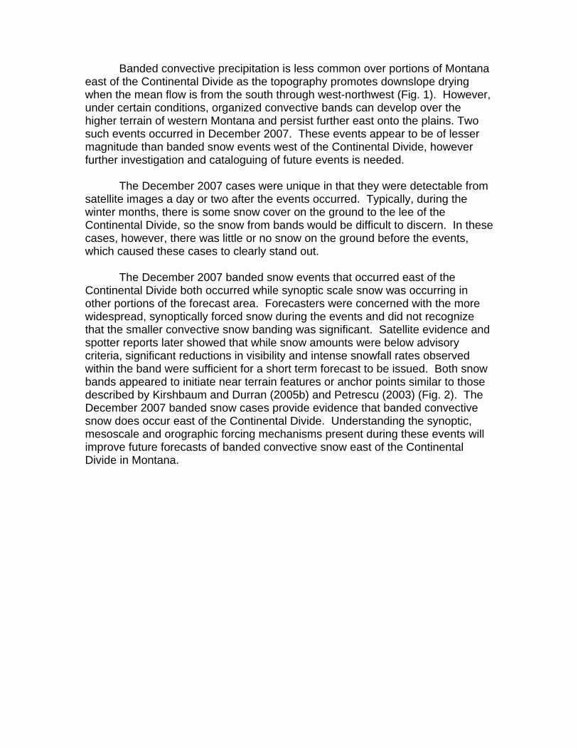
Continental Divide both occurred while synoptic scale snow was occurring in other portions of the forecast area. Forecasters were concerned with the more widespread, synoptically forced snow during the events and did not recognize that the smaller convective snow banding was significant. Satellite evidence and spotter reports later showed that while snow amounts were below advisory criteria, significant reductions in visibility and intense snowfall rates observed within the band were sufficient for a short term forecast to be issued. Both snow bands appeared to initiate near terrain features or anchor points similar to those described by Kirshbaum and Durran (2005b) and Petrescu (2003) (Fig. 2). The December 2007 banded snow cases provide evidence that banded convective snow does occur east of the Continental Divide. Understanding the synoptic, mesoscale and orographic forcing mechanisms present during these events will improve future forecasts of banded convective snow east of the Continental Divide in Montana.

Figure 1. Topography of Montana and surrounding areas. Locations of Montana WSR-88D radars are shown. Box denotes area of interest. The north-northwest to south-southeast aligned area of yellow colors in the left hand side of the box delineates the Continental Divide. The scale of elevations (in thousands of feet MSL) is in the upper left portion of the figure.
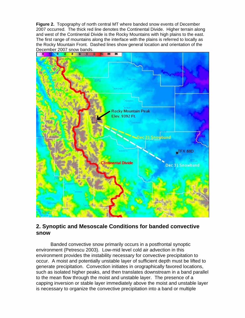
Figure 2. Topography of north central MT where banded snow events of December 2007 occurred. The thick red line denotes the Continental Divide. Higher terrain along and west of the Continental Divide is the Rocky Mountains with high plains to the east. The first range of mountains along the interface with the plains is referred to locally as the Rocky Mountain Front. Dashed lines show general location and orientation of the December 2007 snow bands.
2. Synoptic and Mesoscale Conditions for banded convective snow
Banded convective snow primarily occurs in a postfrontal synoptic environment (Petrescu 2003). Low-mid level cold air advection in this environment provides the instability necessary for convective precipitation to occur. A moist and potentially unstable layer of sufficient depth must be lifted to generate precipitation. Convection initiates in orographically favored locations, such as isolated higher peaks, and then translates downstream in a band parallel to the mean flow through the moist and unstable layer. The presence of a capping inversion or stable layer immediately above the moist and unstable layer is necessary to organize the convective precipitation into a band or multiple
bands (Petrescu 2003). The stable layer forces the organization of convective rolls with downward motion on either side of the band, which further enhances low-level convergence and mid-level divergence within the band (Fig. 3). The stable layer associated with convective banding appears to be frequently associated with either a synoptic scale subsidence inversion due to a building upper level ridge or a lowered tropopause (generally below 300mb). If a stable layer is not present immediately above the moist and unstable layer, convection will likely be disorganized and cellular in nature and therefore not persist over the same area. Petrescu (2003) found that intense snowfall rates may still exist with individual snow showers in disorganized convection, but these cells do not persist over a given location long enough to produce significant accumulations. Unidirectional winds throughout the depth of the moist and unstable layer are necessary to maintain organized bands that persist over the same location. Wind speeds of 15 to 20 m/s (30-40 kts) through the moist and unstable layer appear to be most favorable with higher speeds promoting downslope drying. Figure 3. Schematic of Horizontal Roll convection.
3. December 2007 snow bands over north central MT 21 December 2007
A vigorous upper level low-pressure center moved across Alberta and Saskatchewan on 21 December, with the main trough axis extending south into

north central Montana (Fig. 4). This trough provided the unstable environment in the mid levels to support convection. The 500mb flow also featured an upper level ridge building into western Montana behind the trough, which provided an upper level subsidence inversion that capped the unstable layer (Fig. 5).
Figure 4. 21 December 2007 12km North American Mesoscale Model (NAM12) 3hr forecast of 500mb geopotential heights and absolute vorticity valid at 1500 UTC. The 500mb geopotential height (dam) is shown as solid lines, while the absolute vorticity is color shaded and contoured.
At the surface, a shallow continental polar airmass was drawn south into
the region with a stable cold layer near the ground and an elevated unstable layer above it (Figs. 5 and 7). While surface based convective precipitation would not be expected to occur with the stable layer at the surface, convective precipitation did develop in the elevated mixed layer. Winds through the mixed layer were uniform in direction and speed from the northwest at around 20 m/s (40kts) (Figs. 5 and 6).
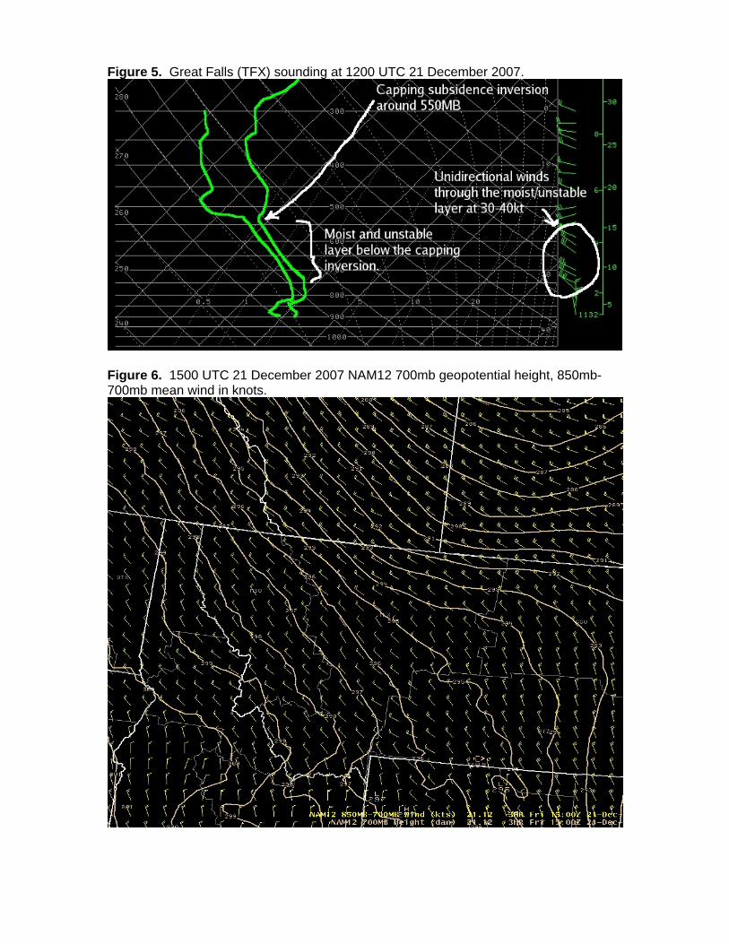
Figure 5. Great Falls (TFX) sounding at 1200 UTC 21 December 2007.
Figure 6. 1500 UTC 21 December 2007 NAM12 700mb geopotential height, 850mb-700mb mean wind in knots.
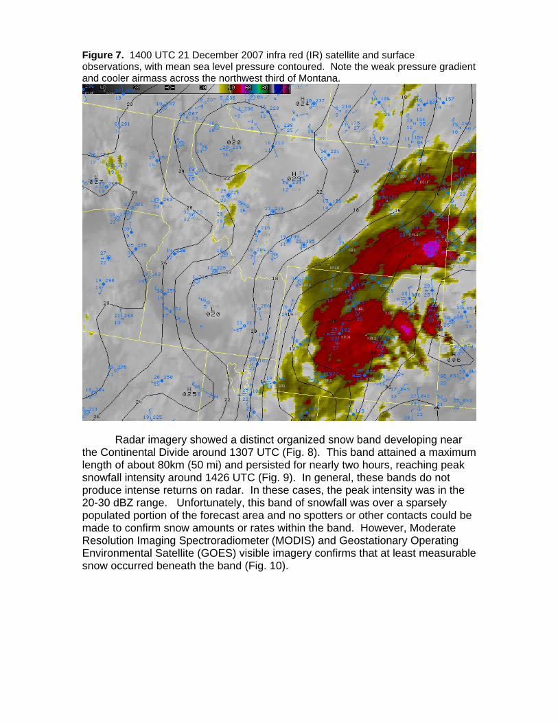
Figure 7. 1400 UTC 21 December 2007 infra red (IR) satellite and surface observations, with mean sea level pressure contoured. Note the weak pressure gradient and cooler airmass across the northwest third of Montana.
Radar imagery showed a distinct organized snow band developing near
the Continental Divide around 1307 UTC (Fig. 8). This band attained a maximum length of about 80km (50 mi) and persisted for nearly two hours, reaching peak snowfall intensity around 1426 UTC (Fig. 9). In general, these bands do not produce intense returns on radar. In these cases, the peak intensity was in the 20-30 dBZ range. Unfortunately, this band of snowfall was over a sparsely populated portion of the forecast area and no spotters or other contacts could be made to confirm snow amounts or rates within the band. However, Moderate Resolution Imaging Spectroradiometer (MODIS) and Geostationary Operating Environmental Satellite (GOES) visible imagery confirms that at least measurable snow occurred beneath the band (Fig. 10).
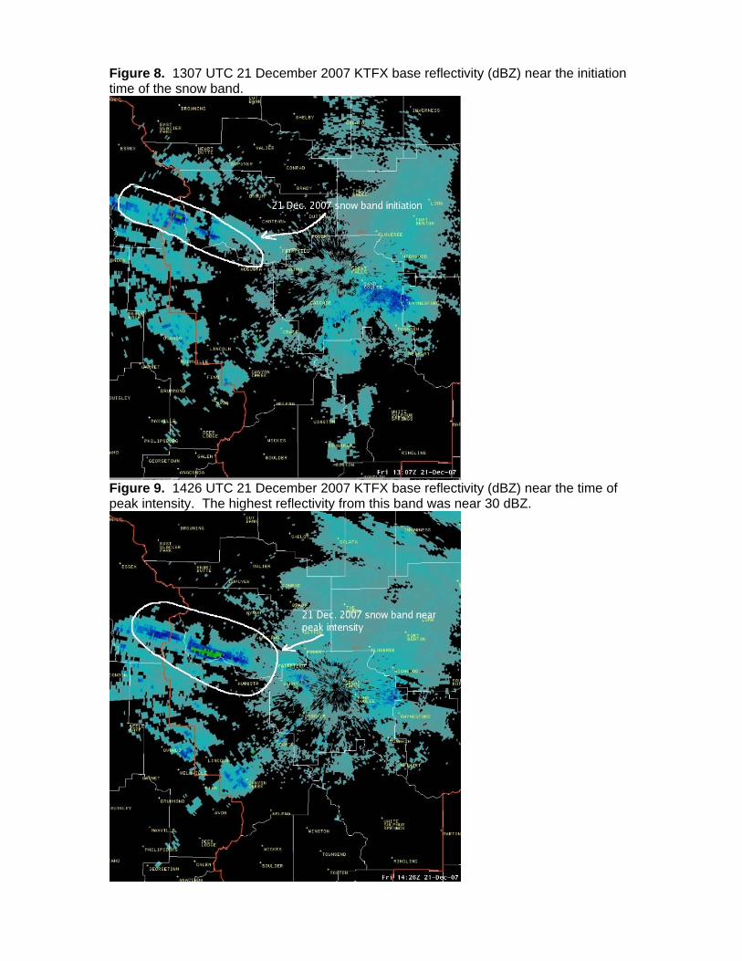
Figure 8. 1307 UTC 21 December 2007 KTFX base reflectivity (dBZ) near the initiation time of the snow band.
Figure 9. 1426 UTC 21 December 2007 KTFX base reflectivity (dBZ) near the time of peak intensity. The highest reflectivity from this band was near 30 dBZ.
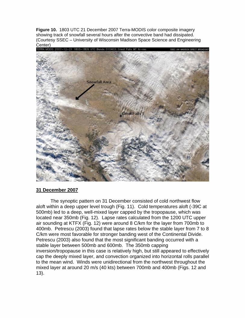
Figure 10. 1803 UTC 21 December 2007 Terra-MODIS color composite imagery showing track of snowfall several hours after the convective band had dissipated. (Courtesy SSEC – University of Wisconsin Madison Space Science and Engineering Center)
31 December 2007
The synoptic pattern on 31 December consisted of cold northwest flow aloft within a deep upper level trough (Fig. 11). Cold temperatures aloft (-39C at 500mb) led to a deep, well-mixed layer capped by the tropopause, which was located near 350mb (Fig. 12). Lapse rates calculated from the 1200 UTC upper air sounding at KTFX (Fig. 12) were around 8 C/km for the layer from 700mb to 400mb. Petrescu (2003) found that lapse rates below the stable layer from 7 to 8 C/km were most favorable for stronger banding west of the Continental Divide. Petrescu (2003) also found that the most significant banding occurred with a stable layer between 500mb and 600mb. The 350mb capping inversion/tropopause in this case is relatively high, but still appeared to effectively cap the deeply mixed layer, and convection organized into horizontal rolls parallel to the mean wind. Winds were unidirectional from the northwest throughout the mixed layer at around 20 m/s (40 kts) between 700mb and 400mb (Figs. 12 and 13).

Figure 11. 1800 UTC 31 December 2007 initialization of 500mb geopotential heights and absolute vorticity. The 500mb geopotential height (dam) is shown as solid lines, while the absolute vorticity is color shaded and contoured.
Figure 12. Great Falls (TFX) upper air sounding from 1200 UTC 31 December 2007
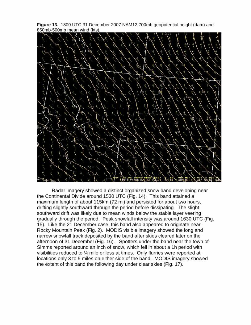
Figure 13. 1800 UTC 31 December 2007 NAM12 700mb geopotential height (dam) and 850mb-500mb mean wind (kts).
Radar imagery showed a distinct organized snow band developing near
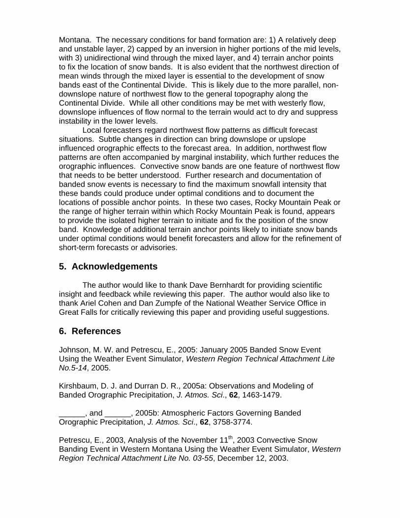
the Continental Divide around 1530 UTC (Fig. 14). This band attained a maximum length of about 115km (72 mi) and persisted for about two hours, drifting slightly southward through the period before dissipating. The slight southward drift was likely due to mean winds below the stable layer veering gradually through the period. Peak snowfall intensity was around 1630 UTC (Fig. 15). Like the 21 December case, this band also appeared to originate near Rocky Mountain Peak (Fig. 2). MODIS visible imagery showed the long and narrow snowfall track deposited by the band after skies cleared later on the afternoon of 31 December (Fig. 16). Spotters under the band near the town of Simms reported around an inch of snow, which fell in about a 1h period with visibilities reduced to ¼ mile or less at times. Only flurries were reported at locations only 3 to 5 miles on either side of the band. MODIS imagery showed the extent of this band the following day under clear skies (Fig. 17).
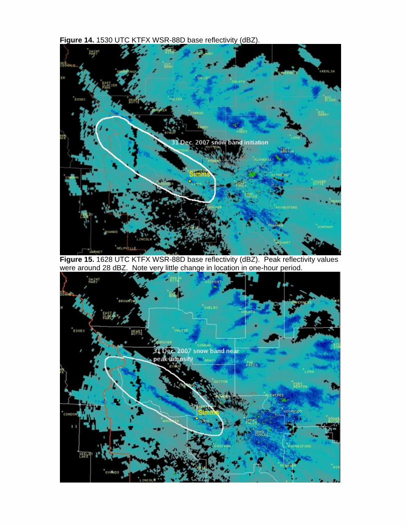
Figure 14. 1530 UTC KTFX WSR-88D base reflectivity (dBZ).
Figure 15. 1628 UTC KTFX WSR-88D base reflectivity (dBZ). Peak reflectivity values were around 28 dBZ. Note very little change in location in one-hour period.
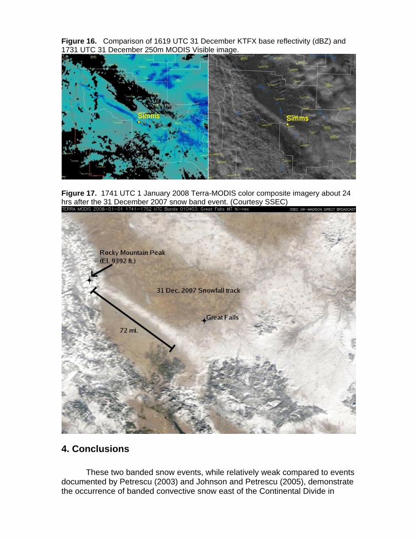
Figure 16. Comparison of 1619 UTC 31 December KTFX base reflectivity (dBZ) and 1731 UTC 31 December 250m MODIS Visible image.
Figure 17. 1741 UTC 1 January 2008 Terra-MODIS color composite imagery about 24 hrs after the 31 December 2007 snow band event. (Courtesy SSEC)
4. Conclusions These two banded snow events, while relatively weak compared to events documented by Petrescu (2003) and Johnson and Petrescu (2005), demonstrate the occurrence of banded convective snow east of the Continental Divide in
Montana. The necessary conditions for band formation are: 1) A relatively deep and unstable layer, 2) capped by an inversion in higher portions of the mid levels, with 3) unidirectional wind through the mixed layer, and 4) terrain anchor points to fix the location of snow bands. It is also evident that the northwest direction of mean winds through the mixed layer is essential to the development of snow bands east of the Continental Divide. This is likely due to the more parallel, non-downslope nature of northwest flow to the general topography along the Continental Divide. While all other conditions may be met with westerly flow, downslope influences of flow normal to the terrain would act to dry and suppress instability in the lower levels. Local forecasters regard northwest flow patterns as difficult forecast situations. Subtle changes in direction can bring downslope or upslope influenced orographic effects to the forecast area. In addition, northwest flow patterns are often accompanied by marginal instability, which further reduces the orographic influences. Convective snow bands are one feature of northwest flow that needs to be better understood. Further research and documentation of banded snow events is necessary to find the maximum snowfall intensity that these bands could produce under optimal conditions and to document the locations of possible anchor points. In these two cases, Rocky Mountain Peak or the range of higher terrain within which Rocky Mountain Peak is found, appears to provide the isolated higher terrain to initiate and fix the position of the snow band. Knowledge of additional terrain anchor points likely to initiate snow bands under optimal conditions would benefit forecasters and allow for the refinement of short-term forecasts or advisories. 5. Acknowledgements The author would like to thank Dave Bernhardt for providing scientific insight and feedback while reviewing this paper. The author would also like to thank Ariel Cohen and Dan Zumpfe of the National Weather Service Office in Great Falls for critically reviewing this paper and providing useful suggestions. 6. References Johnson, M. W. and Petrescu, E., 2005: January 2005 Banded Snow Event Using the Weather Event Simulator, Western Region Technical Attachment Lite No.5-14, 2005. Kirshbaum, D. J. and Durran D. R., 2005a: Observations and Modeling of Banded Orographic Precipitation, J. Atmos. Sci., 62, 1463-1479. ______, and ______, 2005b: Atmospheric Factors Governing Banded Orographic Precipitation, J. Atmos. Sci., 62, 3758-3774. Petrescu, E., 2003, Analysis of the November 11th, 2003 Convective Snow Banding Event in Western Montana Using the Weather Event Simulator, Western Region Technical Attachment Lite No. 03-55, December 12, 2003.