crondall - hants
TRANSCRIPT
Crondall
Crondall
H/HSN 2
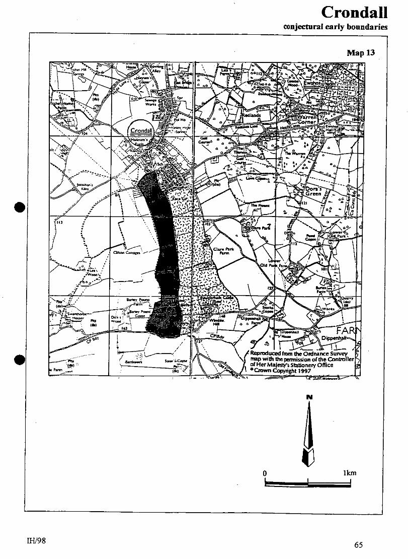
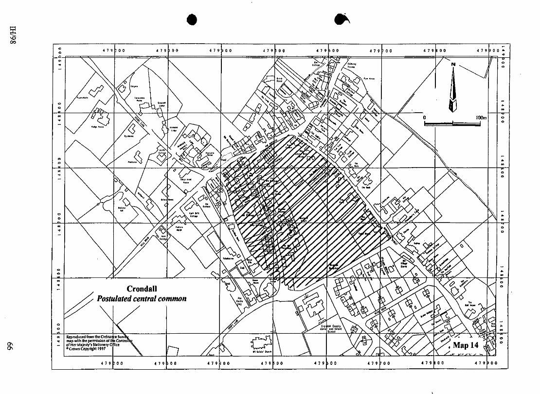
1.0 PARISH Crondall 2.0 HUNDRED Crondall 3.0 NGR SU 479500 148500 4.0 GEOLOGY Upper Chalk, but northern extension of settlement just abounds an island of Valley Gravel and Sand. 5.0 SITE CONTEXT Crondall is a complex settlement which is laid out around an intricate network of routeways. In simple terms, there are three elements. The first is linear and follows a south-west / north-east route along Well Lane / Pankridge Street via The Borough. This conforms to the valley of a small stream, a tributary of the River Hart, which rises from a pond at Hannam’s Farm. The valley floor is a little less than 85m AOD, with sides rising to c. 100m AOD to east and west. The second element extends south-eastwards along the road to Clare Park, climbing gently for all of that distance. The third component is at the south-west extreme of Crondall where the parish church of St Mary stands dominant on rising ground (c. 95m AOD). South-west of, and adjacent to the church, are the remnant buildings of the former Court Farm, the site of Crondall’s manor house. 6.0 PLAN TYPE & DESCRIPTION Small farmstead clusters (including church and manor) with agglomerations Crondall is an amalgam of a number of settlement types. 6.1 Church and manor house/ farmstead The Church of St Mary is C12. The adjacent Court Farm was once the venue for the manor court (VCH 4: 6). In fact, the whole complex is at the north end of a linear land unit which extends south to the parish boundary including within it the Barley Pound ring and bailies (10.0). The boundaries of the land unit are clearly defined by public rights of way (Map 13, page 65: Crondall, conjectural early boundaries). 6.2 Linked farmstead cluster East of the church and manor house unit lies another of similar length which has within it Powderham Castle (motte) close to its southern extreme (Map 13). At various intervals, this land unit has west-east sub-divisions, effectively creating a number of rectangular blocks. The two most northerly blocks are within the present Crondall settlement. One of these is adjacent to, and immediately east of the church (for convenience, land block A). In 1846 it was open space, but today it is occupied by a school (late C19) and modern housing. The second land block lies north-west of the first, the two being separated by Croft Lane. This second block (B) is trapezium-shaped and is delimited by The Borough (north), Dippenhall Street (east), Croft Lane (south) and Church Street (west). Street-fronting properties occupy all but the south side where there is access to the remaining central space. This is much as it was in 1846. However, inspection of the boundaries on the west side of Church Street shows that block B probably once extended further westwards (Map 14, page 66: postulated central common; see 18.0). The rear (west) boundaries of Giffard House,
IH/98 42
Crondall
Crondall
H/HSN 2
Bathurst House, the Old Vicarage, Holly Cottage, Imley and Church Hill Terrace form a gentle arc which, by eye, continues to join Croft Lane south of the Old Parsonage. Confirmation of this gentle curve can be seen in the break-in-line of the access track to Dovas Cottages (NGR: 479412 148758). It is distinctly probable that the properties on the west side of Church Street have been created from the original western edge of block B. It therefore follows that Church Street itself is a relatively late development; the earliest properties aligning it are C17 / 18. It may have originated as a track across a green or common linking what is now The Plume of Feathers (C16) to the church and Court Farm. It is reasonable to suppose that block B was an area of common, and support for this hypothesis is suggested by the fact that the oldest property groups in Crondall lie at each of its four corners. North are the late medieval buildings of Amberley House and Garrett’s Farm. To the east, Limetrees (C15) and Tudor House (C16) accompany Chaundler’s Farm. South is the church and manor (Court Farm). The Plume of Feathers (C16) is situated to the west. These groups of buildings were positioned so as to facilitate ease of access to the common between them. The odd one out, it seems, is the Plume of Feathers because this building sits on the green and possibly represents the earliest encroachment upon it. It was, perhaps, at this time (C16) that the track was formed which was to develop into Church Lane. This new route may have superseded an earlier road which continues south-east from Itchell Lane at Hannam’s Farm, across Well Lane, skirting the rear of the later Church Lane properties, to arrive at All Saints Church near to where Crondall Lodge now stands. If this was the case, then the only remaining evidence for this earlier road is the track which passes Dovas Cottages. 6.3 Irregular rows. Two irregular rows can be identified in Crondall. 6.3.1 The first of these is formed north-east along Well Road / The Borough / Pankridge Street. Five property groupings of C17 or earlier can be proposed (south-east to north-east): Potter’s Hatch, Hannam’s Farm, Amberley House / Garrett’s Farm and Meadow Cottage / Chilloway. The attraction of this area was, no doubt, the series of springs from Hannam’s Farm to Meadow Cottage which feed a small stream that virtually coincides with the road route. 6.3.2 The second row runs from Garrett’s Farm south-east along Dippenhall Street. On this route Limetrees / Chaundler’s Farm is an obvious grouping but there may have been another at the junction with Heath Lane (NGR: 479870 148530) where the Tithe Map shows agricultural buildings that are not evident today. There is a stream close to this route too, but in this case it forms the rear property boundaries parallel to, but c. 160m back (north-east) from the road. 6.4 C17 - C18 agglomeration. During the late C17 and throughout C18 the topography of Crondall was changed by a series of developments. The transformation of Church Street from a track to a road probably occurred at this time, occasioned by the building of The (Old) Parsonage and The (Old) Vicarage. Croft Lane might have been straightened as a part of this scheme, or upgraded from a track. New properties were also constructed along the line of Well Road through to Pankridge Street. Many of these (eg Chilloway Terrace) were planned groupings but others, such as Briary House, were individualistic. A similar process occurred along Dippenhall Street, but more constrained. The general impression is that the Well Road / The Borough / Pankridge Street developments were more ‘industrial’ than those elsewhere; there are
IH/98 43
Crondall
Crondall
H/HSN 2
more small cottage units, a tannery (albeit a C19 building) and oasts at the north end of Dippenhall Street. The presence of a chapel on the north side of The Borough fits into this pattern of growth which continued into C19. The new late C17 - C18 Crondall was providing central services for a wider community, the proliferation of building giving a nucleated look to what had been a network of dispersed settlement. It should be noted that some of the late C17 - C18 construction took the form of rebuilding and this may have been particularly true of the farmhouses and their attendant barns and granaries; even Garrett’s Farmhouse (C15) received some C17 modification. 6.5 Site visit conditions: stong, low sun; dry. 7.0 ARCHAEOLOGICAL POTENTIAL 7.1 AAP Crondall is a large settlement and much of it is within one continuous AAP which (from south to north) includes the church and manor house site to the south-west, continuing northwards along
Church Street (C17 / C18 properties) to adjoin the south- west end of The Borough and Itchell Lane Hannam’s Farm; King’s Head House: Map 9)
Dippenhall Street (east) from Greenacres north to Pankridge Street; Dippenhall Lane (west) from Croft Lane northwards to The Borough (C17 / C18 buildings: Map 9)
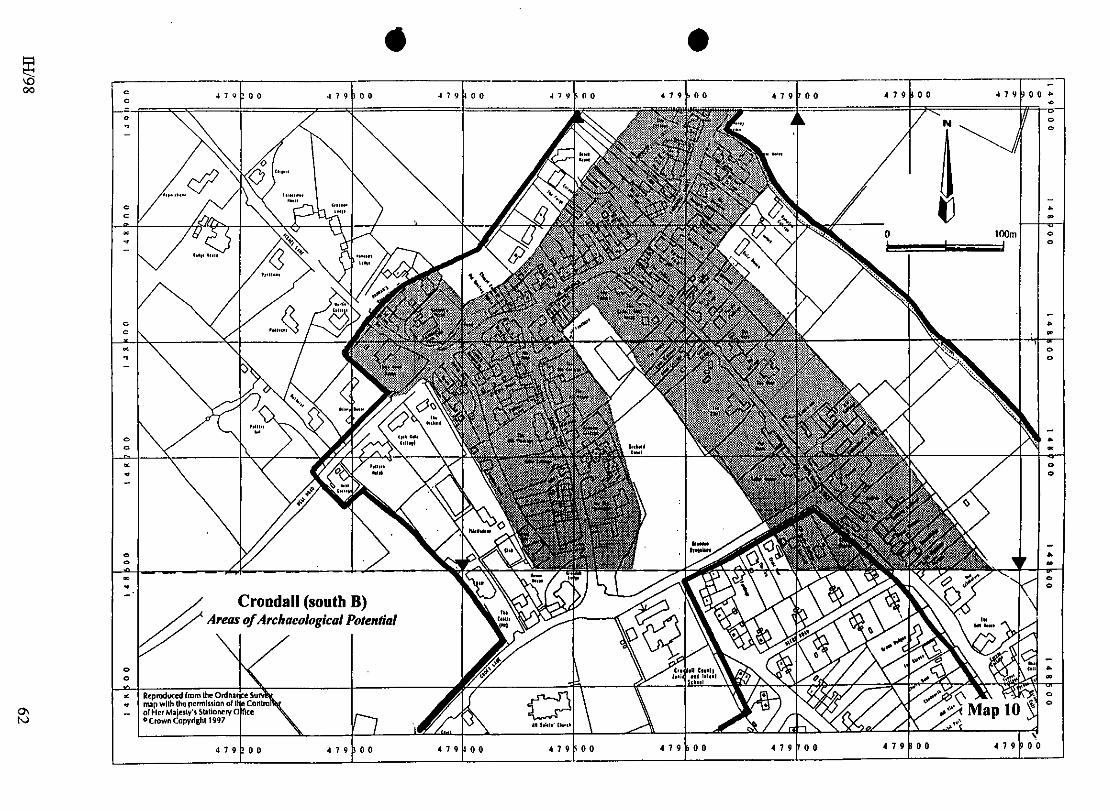
north-eastwards from Itchell Lane, both sides of The Borough are within the AAP (Plume of Feathers C16; otherwise mostly C18: Map 10)
Pankridge Street (south end) which includes late medieval buildings of Amberley House and Garrett’s Farm (Map 10)
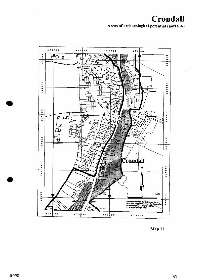
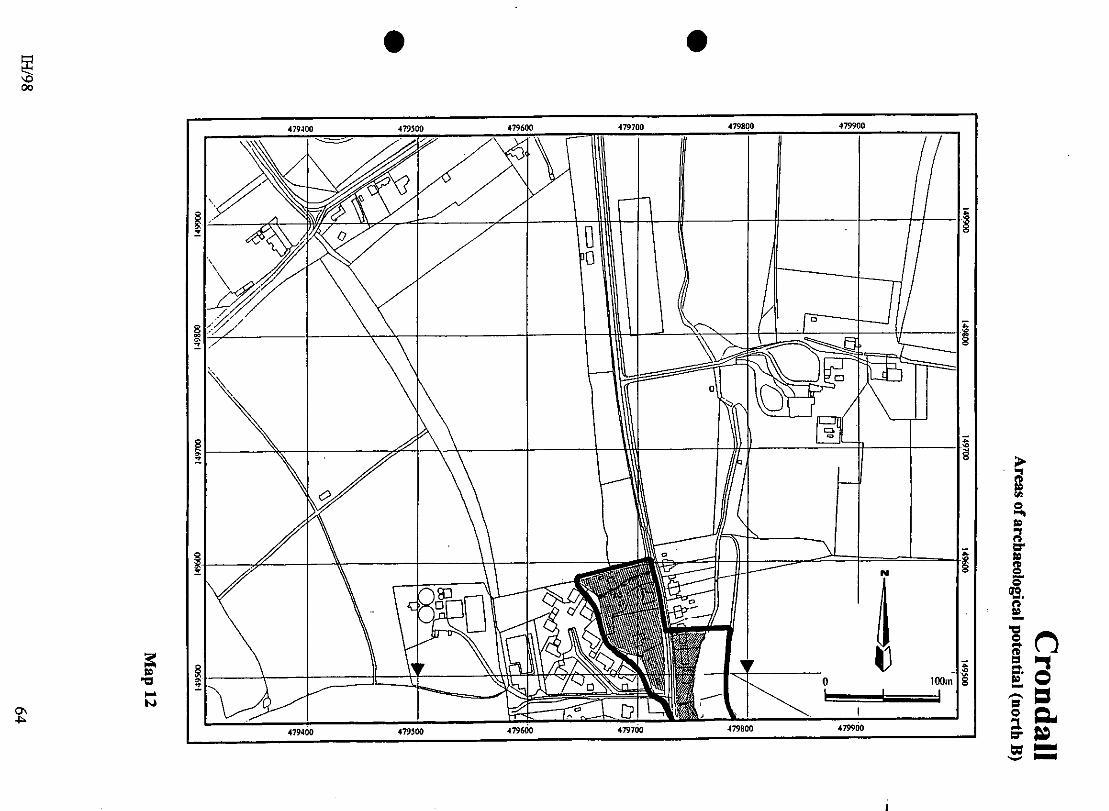
The AAP continues northwards along Pankridge Street, principally along the east side (Map 11 & Map 12.
7.1.1 All of the above include good evidence of C17 or earlier settlement whilst at the same time allowing for the presence of undetected earlier remains within the settlement bounds. 7.2 AsAP 7.2.1 The AsAP focus upon the street frontage properties and the church / manor house complex. For the most part, backlands of properties are included but rear fields and paddocks are not since there is no evidence for settlement in these spaces. North along Pankridge Street an attenuated settlement layout is suspected and this notion is reflected in the location of the AAP and AsHAP (Maps 9 to 12). 7.2.2 Any archaeological opportunities would help to illuminate the development processes of this important Hundred centre. 7.3 Buildings Surveys There is much potential for a study of building materials in Crondall. The possible use of Roman fabric in the church requires further assessment, particularly if areas of render become detached from the building. However, there is a distinct possibility that materials from the identified Roman buildings in the area (10.0) have been re-used in other structures. Similarly, what happened to the materials from the former crossing of the church (8.0)? Bricks were being used for the construction of the new bell tower (mid C17). A source for these is likely to to lie in the brickfields of Hart and quite
IH/98 44
Crondall
Crondall
H/HSN 2
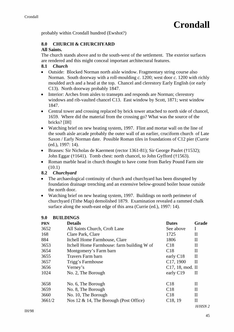
probably within Crondall hundred (Ewshot?) 8.0 CHURCH & CHURCHYARD All Saints. The church stands above and to the south-west of the settlement. The exterior surfaces are rendered and this might conceal important architectural features. 8.1 Church Outside: Blocked Norman north aisle window. Fragmentary string course also
Norman. South doorway with a roll-moulding c. 1200; west door c. 1200 with richly moulded arch and a head at the top. Chancel and clerestory Early English (or early C13). North doorway probably 1847.
Interior: Arches from aisles to transepts and responds are Norman; clerestory windows and rib-vaulted chancel C13. East window by Scott, 1871; west window 1847.
Central tower and crossing replaced by brick tower attached to north side of chancel, 1659. Where did the material from the crossing go? What was the source of the bricks? [IH]
Watching brief on new heating system, 1997. Flint and mortar wall on the line of the south aisle arcade probably the outer wall of an earlier, cruciform church of Late Saxon / Early Norman date. Possible Roman tiles in foundations of C12 pier (Currie (ed.), 1997: 14).
Brasses: Sir Nicholas de Kaerment (rector 1361-81); Sir George Paulet (†1532); John Eggar (†1641). Tomb chest: north chancel, to John Gyfford (†1563).
Roman marble head in church thought to have come from Barley Pound Farm site (10.1)
8.2 Churchyard The archaeological continuity of church and churchyard has been disrupted by
foundation drainage trenching and an extensive below-ground boiler house outside the north door.
Watching brief on new heating system, 1997. Buildings on north perimeter of churchyard (Tithe Map) demolished 1879. Examination revealed a rammed chalk surface along the south-east edge of this area (Currie (ed.), 1997: 14).
9.0 BUILDINGS PRN Details Dates Grade 3652 All Saints Church, Croft Lane See above I 168 Clare Park, Clare 1725 II 884 Itchell Home Farmhouse, Clare 1806 II 3653 Itchell Home Farmhouse: farm building W of C18 II 3654 Montgomery’s Farm barn C18 II 3655 Travers Farm barn early C18 II 3657 Trigg’s Farmhouse C17, 1900 II 3656 Verney’s C17, 18, mod. II 1024 No. 2, The Borough early C19 II 3658 No. 6, The Borough C18 II 3659 No. 8, The Borough C18 II 3660 No. 10, The Borough C18 II 3661/2 Nos 12 & 14, The Borough (Post Office) C18, 19 II
IH/98 45
Crondall
Crondall
H/HSN 2
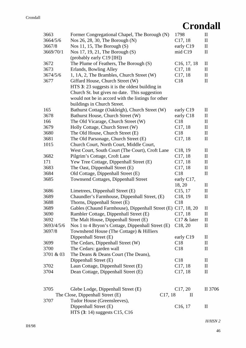
3663 Former Congregational Chapel, The Borough (N) 1798 II 3664/5/6 Nos 26, 28, 30, The Borough (N) C17, 18 II 3667/8 Nos 11, 15, The Borough (S) early C19 II 3669/70/1 Nos 17, 19, 21, The Borough (S) mid C19 II (probably early C19 [IH]) 3672 The Plume of Feathers, The Borough (S) C16, 17, 18 II 3673 Erlands, Bowling Alley C17, 18 II 3674/5/6 1, 1A, 2, The Brambles, Church Street (W) C17, 18 II 3677 Giffard House, Church Street (W) C18 II HTS 3: 23 suggests it is the oldest building in Church St. but gives no date. This suggestion would not be in accord with the listings for other buildings in Church Street. 165 Bathurst Cottage (Oakleigh), Church Street (W) early C19 II 3678 Bathurst House, Church Street (W) early C18 II 166 The Old Vicarage, Church Street (W) C18 II 3679 Holly Cottage, Church Street (W) C17, 18 II 3680 The Old House, Church Street (E) C18 II 3681 The Old Parsonage, Church Street (E) C17, 18 II 1015 Church Court, North Court, Middle Court, West Court, South Court (The Court), Croft Lane C18, 19 II 3682 Pilgrim’s Cottage, Croft Lane C17, 18 II 171 Yew Tree Cottage, Dippenhall Street (E) C17, 18 II 3683 The Oast, Dippenhall Street (E) C17, 18 II 3684 Old Cottage, Dippenhall Street (E) C18 II 3685 Townsend Cottages, Dippenhall Street early C17, 18, 20 II 3686 Limetrees, Dippenhall Street (E) C15, 17 II 3689 Chaundler’s Farmhouse, Dippenhall Street, (E) C18, 19 II 3688 Thorns, Dippenhall Street (E) C18 3689 Gables (Chaund Farmhouse), Dippenhall Street (E) C17, 18, 20 II 3690 Rambler Cottage, Dippenhall Street (E) C17, 18 II 3692 The Malt House, Dippenhall Street (E) C17 & later II 3693/4/5/6 Nos 1 to 4 Bryon’s Cottage, Dippenhall Street (E) C18, 20 II 3697/8 Townshend House (The Cottage) & Hilliers Dippenhall Street (E) early C19 II 3699 The Cedars, Dippenhall Street (W) C18 II 3700 The Cedars: garden wall C18 II 3701 & 03 The Deans & Deans Court (The Deans), Dippenhall Street (E) C18 II 3702 Laun Cottage, Dippenhall Street (E) C17, 18 II 3704 Dean Cottage, Dippenhall Street (E) C17, 18 II 3705 Glebe Lodge, Dippenhall Street (E) C17, 20 II 3706 The Close, Dippenhall Street (E) C17, 18 II 3707 Tudor House (Greensleeves), Dippenhall Street (E) C16, 17 II HTS (3: 14) suggests C15, C16
IH/98 46
Crondall
Crondall
H/HSN 2
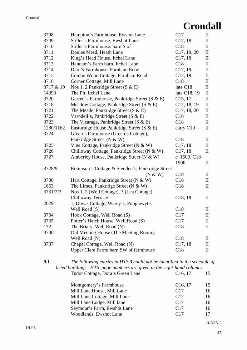
3708 Hampton’s Farmhouse, Ewshot Lane C17 II 3709 Stiller’s Farmhouse, Ewshot Lane C17, 18 II 3710 Stiller’s Farmhouse: barn S of C18 II 3711 Doules Mesd, Heath Lane C17, 19, 20 II 3712 King’s Head House, Itchel Lane C17, 18 II 3713 Hannam’s Farm barn, Itchel Lane C18 II 3714 Dare’s Farmhouse, Farnham Road C17, 19 II 3715 Combe Wood Cottage, Farnham Road C17, 19 II 3716 Corner Cottage, Mill Lane C18 II 3717 & 19 Nos 1, 2 Pankridge Street (S & E) late C18 II 14393 The Pit, Itchel Lane late C18, 19 II 3720 Garrett’s Farmhouse, Pankridge Street (S & E) C15, 17 II 3718 Meadow Cottage, Pankridge Street (S & E) C17, 18, 19 II 3721 The Meade, Pankridge Street (S & E) C17, 18, 20 II 3722 Varndell’s, Pankridge Street (S & E) C18 II 3723 The Vicarage, Pankridge Street (S & E) C18 II 1280/1162 Eastbridge House Pankridge Street (S & E) early C19 II 3724 Green’s Farmhouse (Green’s Cottage), Pankridge Street (N & W) C18 II 3725 Vine Cottage, Pankridge Street (N & W) C17, 18 II 3726 Chilloway Cottage, Pankridge Street (N & W) C17, 18 II 3727 Amberley House, Pankridge Street (N & W) c. 1500, C18 1900 II 3728/9 Robinson’s Cottage & Stenden’s, Pankridge Street (N & W) C18 II 3730 Hart Cottage, Pankridge Street (N & W) C18 II 1663 The Limes, Pankridge Street (N & W) C18 II 3731/2/3 Nos 1, 2 (Well Cottage), 3 (Lea Cottage) Chilloway Terrace C18, 19 II 2029 1, Dovas Cottage, Warey’s, Popplewyte, Well Road (S) C18 II 3734 Hook Cottage, Well Road (S) C17 II 3735 Potter’s Hatch House, Well Road (S) C17 II 172 The Briary, Well Road (N) C18 II 3736 Old Meeting House (The Meeting Room), Well Road (N) C18 II 3737 Chapel Cottage, Well Road (N) C17, 18 II Upper Clare Farm: barn SW of farmhouse C18 II 9.1 The following entries in HTS 3 could not be identified in the schedule of listed buildings. HTS page numbers are given in the right-hand column. Tudor Cottage, Dora’s Green Lane C16, 17 15 Montgomery’s Farmhouse C16, 17 15 Mill Lane House, Mill Lane C17 16 Mill Lane Cottage, Mill Lane C17 16 Mill Lane Lodge, Mill lane C17 16 Seymour’s Farm, Ewshot Lane C17 16 Woodlands, Ewshot Lane C17 17
IH/98 47
Crondall
Crondall
H/HSN 2
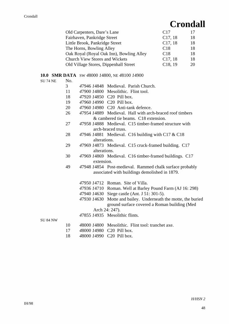
Old Carpenters, Dare’s Lane C17 17 Fairhaven, Pankridge Street C17, 18 18 Little Brook, Pankridge Street C17, 18 18 The Horns, Bowling Alley C18 18 Oak Royal (Royal Oak Inn), Bowling Alley C18 18 Church View Stores and Wickets C17, 18 18 Old Village Stores, Dippenhall Street C18, 19 20 10.0 SMR DATA SW 48000 14800, NE 48100 14900 SU 74 NE No. 3 47946 14848 Medieval. Parish Church. 11 47900 14800 Mesolithic. Flint tool. 18 47920 14850 C20 Pill box. 19 47960 14990 C20 Pill box. 20 47960 14980 C20 Anti-tank defence. 26 47954 14889 Medieval. Hall with arch-braced roof timbers & cambered tie beams. C18 extension. 27 47958 14888 Medieval. C15 timber-framed structure with arch-braced truss. 28 47946 14881 Medieval. C16 building with C17 & C18 alterations. 29 47969 14873 Medieval. C15 cruck-framed building. C17 alterations. 30 47969 14869 Medieval. C16 timber-framed buildings. C17 extension. 49 47948 14854 Post-medieval. Rammed chalk surface probably associated with buildings demolished in 1879. 47950 14712 Roman. Site of Villa. 47936 14710 Roman. Well at Barley Pound Farm (AJ 16: 298) 47940 14630 Siege castle (Ant. J 51: 301-5). 47930 14630 Motte and bailey. Underneath the motte, the buried ground surface covered a Roman building (Med Arch 24: 247). 47855 14935 Mesolithic flints. SU 84 NW 10 48000 14800 Mesolithic. Flint tool: tranchet axe. 17 48000 14980 C20 Pill box. 18 48000 14990 C20 Pill box.
IH/98 48
Crondall
Crondall
H/HSN 2
10.1 Hampshire Romano-British Settlements survey No. 142 480150 147700 Clare Farm. NMR: SU74 NE7 / 243750 NAR: SU74 NE 7 479360 147100 Barley Pound Farm (the church guide says Garrett’s Farm and presumably this is incorrect). Mosaic Pavement found 1817. Coin hoard found in villa vicinity. 11.0 ADDITIONAL SITES / FEATURES 1 479480 148614 to 479414 148758 ancient boundary 2 479860 149300 site of building, 1846 3 479870 149340 site of barn, 1846 4 479510 148555 approx. centre of buildings group, 1846 5 479370 148445 site of barn associated with manor complex, 1846 12.0 CARTOGRAPHIC SOURCES Tithe Map 21M65/F7/57/2 (1846/47) GSGB 284 Basingstoke OS 1: 2500 SW 479100 148200, NE 480205 149600 OS 1:25000 Pathfinder 1224 (SU 64/74), Lasham and Alton (North) and 1225 (SU 84/94), Farnham and Godalming. 13.0 BIBLIOGRAPHY Austin D and Hill D 1972 Boundaries of Itchell and Crondall Hampshire Field Club and Archaeological Society 27 (for 1970): 63-4. Baigent FJ (ed) 1891 A Collection of Records and Documents Relating to the Manor of Crondal in the County of Southampton. Part 1: Historical and Manorial. London, Simpkin & Co. Ltd. Butterfield RP 1948 Monastery and Manor: the History of Crondall. Farnham, EW Langham. Currie CK (ed) 1997 All Saints Church, Crondall. Hampshire Field Club and Archaeological Society Newsletter 28: 14 Page W (ed) 1911 The Victoria County Histories of the Parishes of England. Vol. 4 Hampshire & the Isle of Wight. Westminster, Constable & Co. Ltd. Stocks CD 1905 A History of Crondall and Yateley. Winchester, Warren & Son. 14.0 PRIMARY HISTORIC SOURCES 14.1 Domesday Book 3, 8 Bishop of Winchester (for the supplies of the monks of Winchester). It was always in the (lands of the) Church. Before 1066 there were 50 hides; then and now it paid tax for 40 hides. Land for 29 ploughs. In lordship 4 ploughs; 45 villagers and 11 smallholders with 25 ploughs; A church at 20s; 12 slaves; woodland at 80 pigs from pasturage. value before 1066 £15 10s; later £6; now £24. Germanus holds from the Bishop 8 hides of this land in Itchel and Cove. Leofwin and Wulfward held if from the Bishop jointly; they could not go whither they would. Each
IH/98 49
Crondall
Crondall
H/HSN 2
had a hall; when Germanus acquired it there was only one hall. He had in lordship 3 ploughs; 20 villagers and 10 smallholders with 6 ploughs; 6 slaves. A mill at 3s; meadow, 2 acres; woodland at 15 pigs pasturage. The value was £6; later 40s; now £8. William holds 3 virgates of this manor from the Bishop in Badley (ie Clare Park since C16 [VCH 4: 7-8]). Aelfric held it from the Bishop like a villager. There is 1 plough and 1 smallholder with 4 slaves. The entry includes Long Sutton (this volume) and Farnborough (Rushmore). 14.2 Subsidy Rolls 1334 £0.13. 2 1524 1st survey: Not listed. 2nd survey: £2.17. 8 (20 taxpayers) 14.3 Manorial Documents Crondall Customary 1567 An indenture between the Dean and Chapter of
Winchester and the tenants of the manor. Every tenant surrendered his estate and had reseisin (replacement) of it from the steward. The document gives a list of all the tenats in Crondall, with amount, description and value held by each (VCH 4: 6).
The following were manors of Crondall: Itchell, Badley (Clare Park), Dippenhall (a sub-manor of Crondall), Ewshot (part of Itchell manor from 1579), Crookham, Swanthorpe. Eastbridge was a so-called manor (VCH 4: 9). Domesday gives Long Sutton (with Well) as a sub-manor of Crondall.
Documents listed under Crondall at HRO. 14.4 Hearth Tax 1665 85 hearths chargeable (29 houses) 21 hearths not chargeable (20 houses). Total: 49 houses. 15.0 PLACE NAME 873 x 888 (aet) crundellan; 955 x 958 (aet) crundelan; 968 x 971 (aet) crundelom; 1086 Crundele. OE ‘at the (chalk-) pits’. 16.0 PHOTOGRAPHS 17.0 OTHER PROJECT ELEMENTS 17.1 Pre-Conquest Charters AD 973 x 974. King Edgar to Old Minster, Winchester; grant of land at Crondall,
Hants (259 / 820) c. AD 968 x 971. Will of Ælfheah, ealdorman, including bequests of land at
....Crondall, Hants. to Old Minster, Winchester;....(415 / 1485) AD 955 x 958. Will of Ælfsige, bishop, concerning land at...... Crondall (and other
locations).... Hants.... the beneficiaries including the king and Old and New Minsters, Winchester (417 / 1491)
AD 873 x 888. Will of King Alfred (including) bequest of land at.... Crondall.....
IH/98 50
Crondall
Crondall
H/HSN 2
Hants....; the beneficiaries including Winchester (Cathedral) and the king’s children (422 / 1507)
Boundary between Crondall and Elvetham, Hants. (434 / 1558) Bounds of Crondall and Itchell, Hants. (434 / 1559) AD 979. Ælfnoth (Ælnoth) to St. Peter’s, Winchester; memorandum of grant of land
at Crondall, Hants. (475 / 1817) Held by the Bishop of Winchester until 1224; Prior and Convent of St. Swithun until
1539; the King until 1541; Dean and Chapter of Winchester (VCH 4: 6). 17.2 Other parish settlements include: Barley Pound 47960 14660 1221, Berglegh (Barley Clearing) Canny Down 943, cannaen down (Can Valley) Clare Park (Badley)48070 14790 1086, Baddeleie (Bad(d)a’s Clearing or Wood) Crondall Marsh 47990 14980 1272, East Chebrigge (East Bridge on Stream from Itchell) Heath House 1287, La Heth (home of Geoffrey de la Heth) Itchel Home Farm 47840 14920 973, (on) icaeles aewilmas (at the source of icael) Lee Wood 1267, Longa Mora (Long Moor) Mill Lane 47860 15030 1248, Molendino (Home of Niche Molendino) Pencott Farm 47840 14880 1346, atte Penne (Home of John atte Penne) Rigden’s Copse 1327, atte Rigge (Home of Rich atte Rigge) Stock’s Copse 1329, la Stokke (Home of Adam de la Stokke) Swanthorpe Farm 47740 14790 12--, Swanethorpe (Outlying Hamlet of the Pigs) Church Crookham (Fleet) and part of Dippenhall (Farnham, Surrey), Ewshot and
Swanthorpe were once tithings of Crondall (VCH 4: 5).
17.3 Medieval deer park at Itchell
IH/98 51
Crondall
Crondall
H/HSN 2 IH/98
52
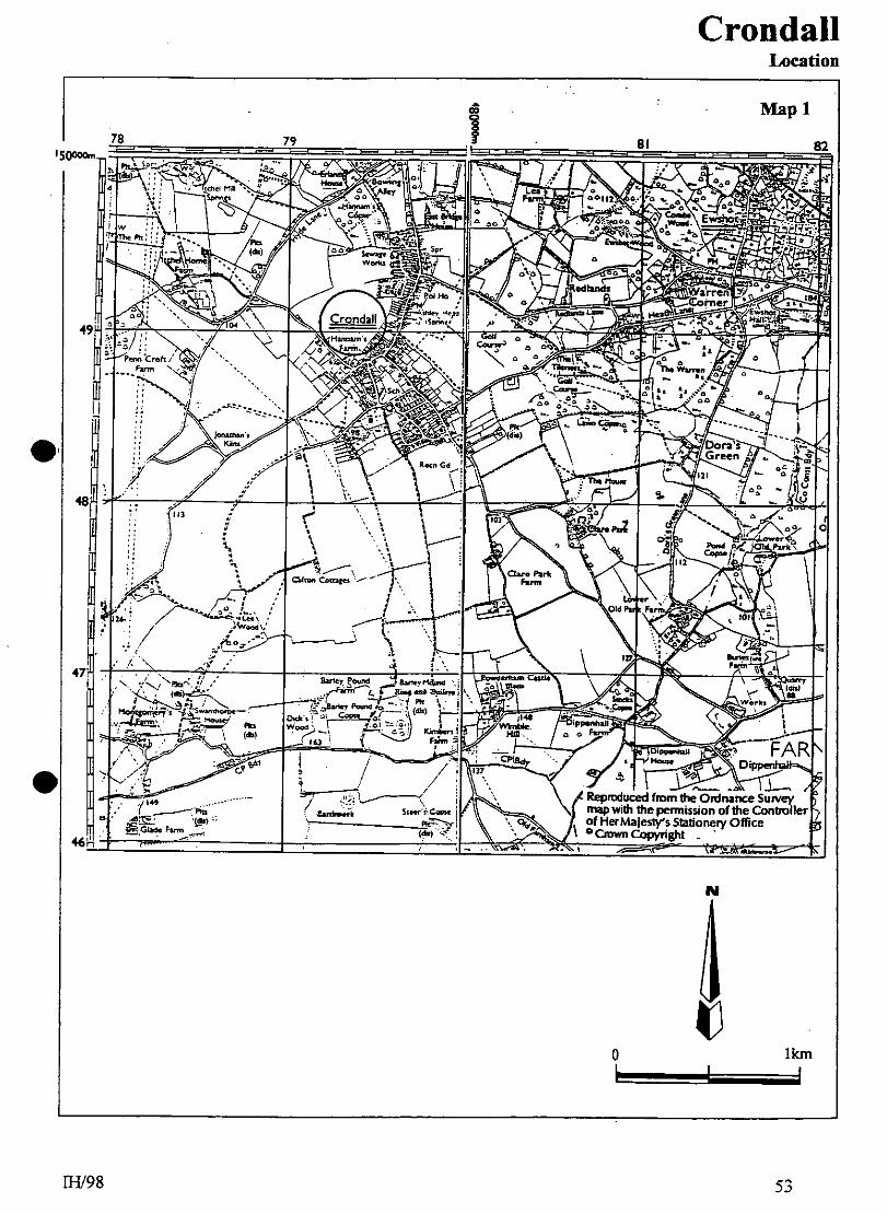
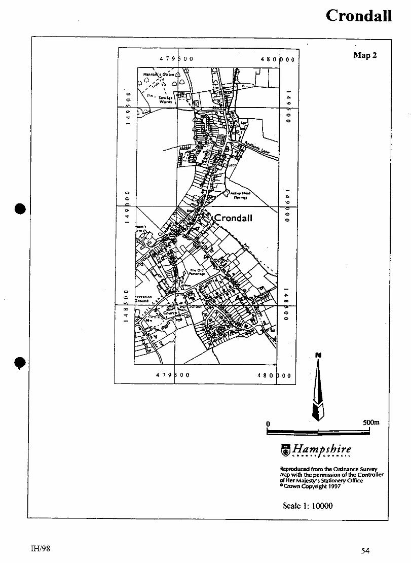
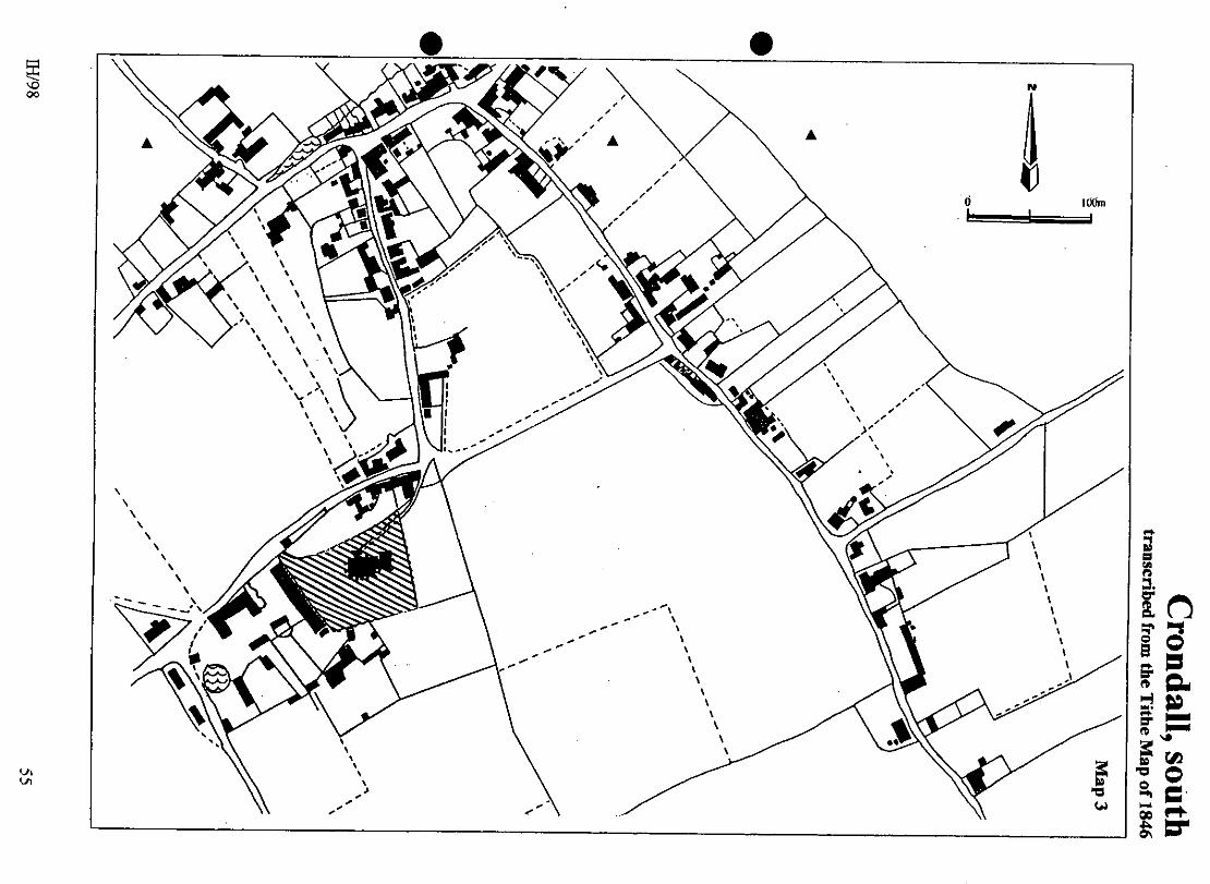
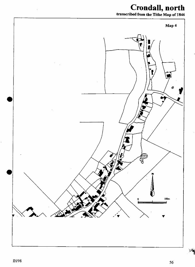
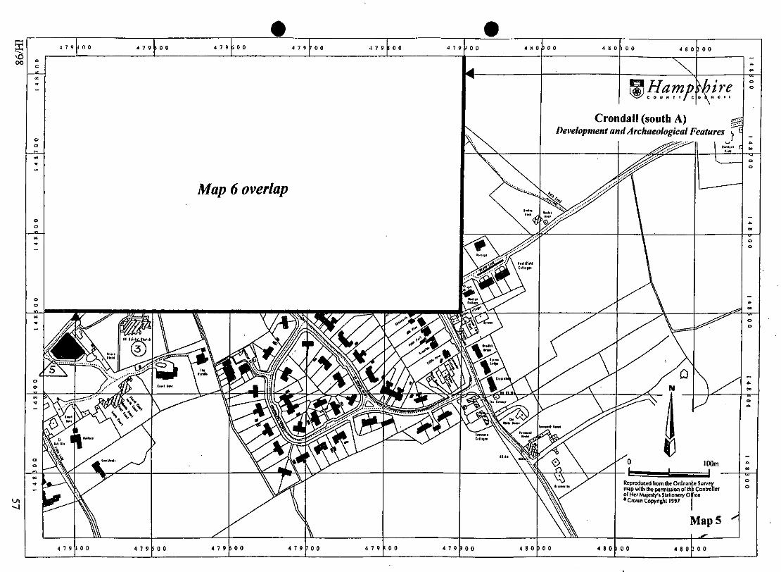
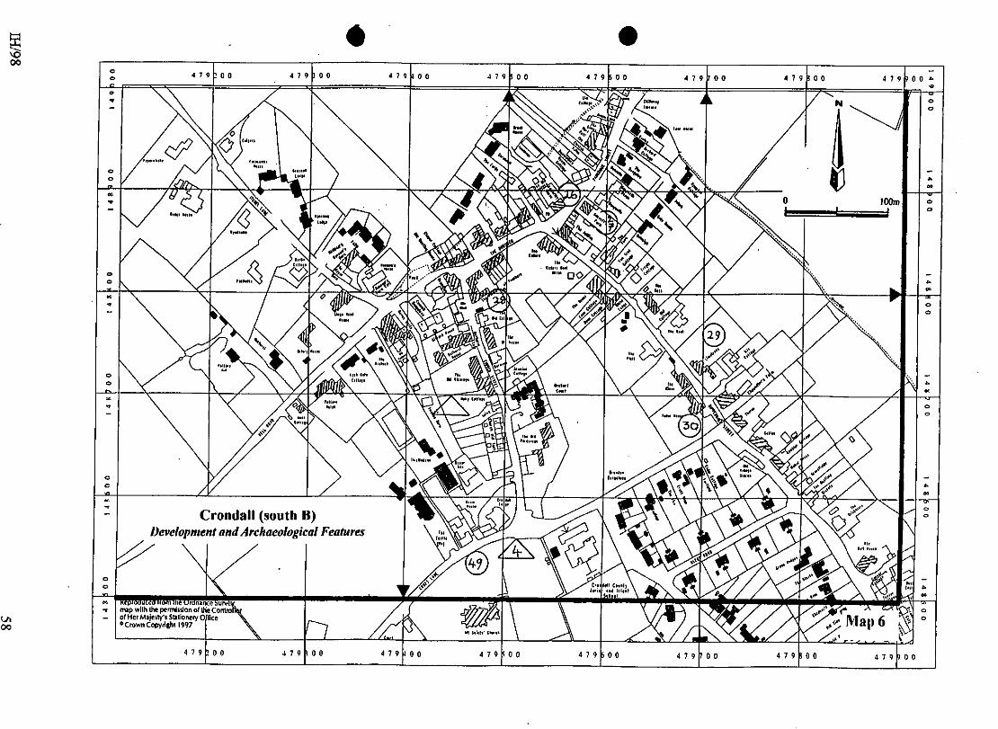
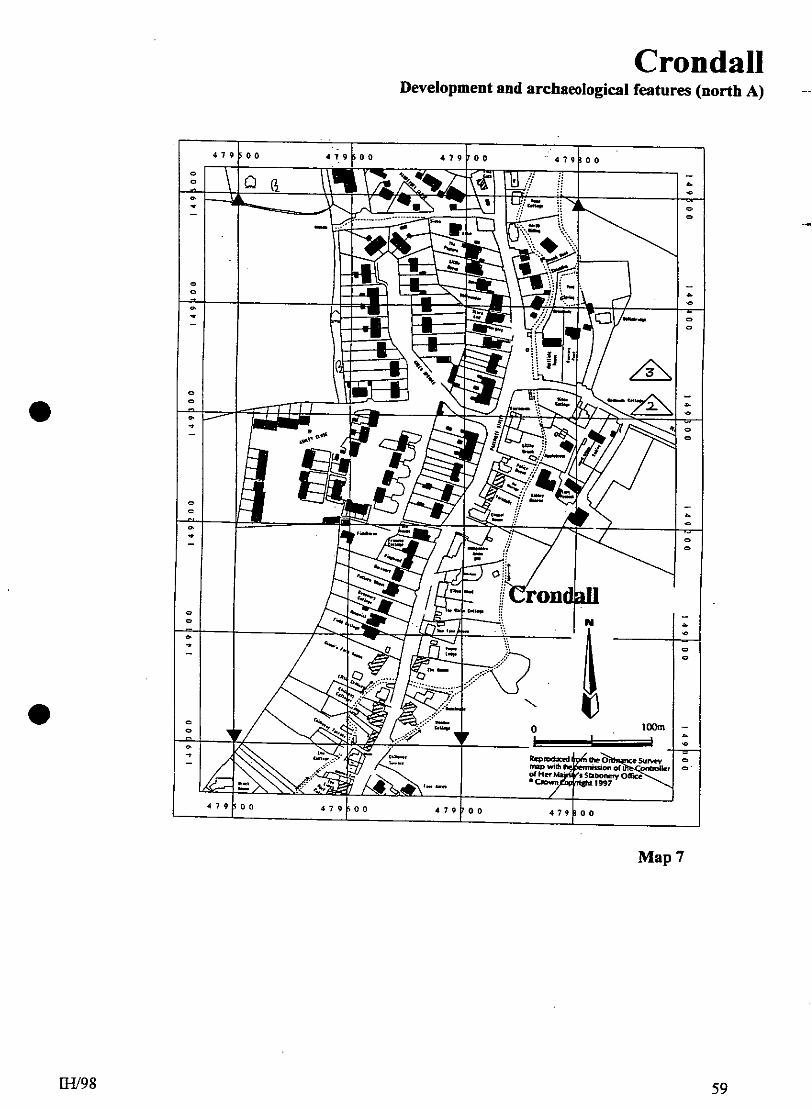
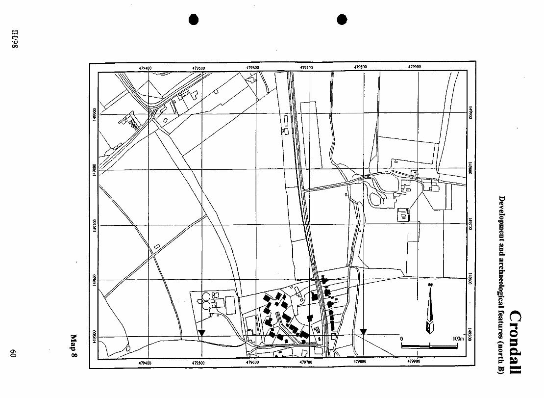
18.0 ILLUSTRATIONS 1 Location map at 1: 25000 2 Location map at 1: 10000 3 Tithe Map transcription at 1: 2500; Crondall (south) 4 Tithe Map transcription at 1: 2500; Crondall (north) 5 Map: Development and Archaeological Features at 1: 2500; Crondall
(south A) 6 Map: Development and Archaeological Features at 1: 2500; Crondall
(south B) 7 Map: Development and Archaeological Features at 1: 2500; Crondall
(north A) 8 Map: Development and Archaeological Features at 1: 2500; Crondall
(north B) 9 Map: Areas of Archaeological Potential at 1: 2500; Crondall (south A) 10 Map: Areas of Archaeological Potential at 1: 2500; Crondall (south B) 11 Map: Areas of Archaeological Potential at 1: 2500; Crondall (north A) 12 Map: Areas of Archaeological Potential at 1: 2500; Crondall (north B) 13 Map: conjectural early boundaries at 1: 25000 14 Map: postulated central common at 1: 2500