cultivating a common ground: community gardens as urban
TRANSCRIPT
University of Massachusetts AmherstScholarWorks@UMass AmherstLandscape Architecture & Regional PlanningMasters Projects Landscape Architecture & Regional Planning
9-2010
Cultivating a Common Ground: CommunityGardens as Urban Infill in Springfield,MassachusettsChristopher J. JennetteUniversity of Massachusetts - Amherst, [email protected]
Follow this and additional works at: https://scholarworks.umass.edu/larp_ms_projects
Part of the Landscape Architecture Commons
This Article is brought to you for free and open access by the Landscape Architecture & Regional Planning at ScholarWorks@UMass Amherst. It hasbeen accepted for inclusion in Landscape Architecture & Regional Planning Masters Projects by an authorized administrator of ScholarWorks@UMassAmherst. For more information, please contact [email protected].
Jennette, Christopher J., "Cultivating a Common Ground: Community Gardens as Urban Infill in Springfield, Massachusetts" (2010).Landscape Architecture & Regional Planning Masters Projects. 31.Retrieved from https://scholarworks.umass.edu/larp_ms_projects/31

Cultivatinga common
GroundCommunity Gardens as Urban Infill in Springfield, Massachusetts
C h r i s t o p he r J J e n ne t t e
A Master’s Project Presented By
University of Massachusetts, Amherst Department of Landscape Architecture and Regional Planning
M a s t e r o f L a n d s c a p e A r c h i t e c t u r e C a n d i d a t e , 2 0 1 0

Cultivating a Common Ground Community Gardens as Urban Infill in Springfield, Massachusetts
A M a s t e r ’ s P r o j e c t P r e s e n t e d B y :
C h r i s t o p h e r J J e n n e t t e
M a s t e r o f L a n d s c a p e A r c h i t e c t u r e
D e p a r t m e n t o f L a n d s c a p e A r c h i t e c t u r e & R e g i o n a l P l a n n i n g
U n i v e r s i t y o f M a s s a c h u s e t t s , A m h e r s t
E l i z a b e t h B r a b e cD e p a r t m e n t H e a d
M a r k H a m i nM e m b e r
S i g r i d M i l l e r P o l l i nM e m b e r
F r a n k S l e e g e r sM e m b e r
M a r k L i n d h u l tC h a i r

5
AcknowledgmentsThanks to all of my Faculty and Colleagues at the University of Massachusetts, for supporting me throughout the adventures of graduate education, and for constantly challenging me to think larger, more boldly, and more creatively.
Special thanks to my advisors on this project, Mark Lindhult, not only for helping me muddle through the process of finding a clear path through this research, but for the guidance and support he has provided throughout my time at UMass. Dr. Mark Hamin, for pushing me to think through every decision critically, and for giving me the tools to engage with planning issues in a substantive and thoughtful way. Frank Sleegers, for giving me a great set of urban design skills, and for encouraging me to fully explore some of my more off-beat design solutions. Sigrid Miller-Pollin, for sharing her unique, well-informed point of view, and for helping me to think in a refreshingly different creative capacity. Thanks to my entire committee for the enthusiasm and sense of humor that made this process a fun, memorable experience.
Thanks to my family and friends for their invaluable support, humor, and encouragement. Finally - thanks to Linnea, who made me laugh, reminded me to eat, and kept me company - her support has meant everything.

7
Tableof Contents
1 Introduction - 81.1 Goals & Objectives
2 Current Conditions in Springfield - 122.1 Challenges to Community Gardening
3 Literature Review - 163.1 The Impacts of Vacancy and Abandonment3.2 Vacancy, Abandonment, and Neighborhood Morale3.3 The Benefits of Community Gardens3.4 Use, Perception, and the Importance of Aesthetics3.5 Major Obstacles and Potential Strategies
4 Methodology - 384.1 GIS Analysis and Assessment4.2 Case Study Research4.3 Design Development
5 GIS Analysis & Assessment Discussion - 425.1 Target Neighborhood Selection5.2 Demographic Analysis5.3 Existing Open Space5.4 Neighborhood Inventory5.5 Spatial Analysis5.6 Focus Area & Prioritization Criteria
6 Case Study Research - 606.1 Seattle: P-Patch Community Gardens 6.2 The Story of Flint6.3 Bedford-Stuyvesant Community Garden
7 Design Development - 767.1 Neighborhood Plan & Program Elements7.2 The Story from the Street7.3 Site Specific Designs 7.3.1. Quincy Street Garden 7.3.2. Orleans Street Garden 7.3.3. Dunbar Community Garden
8 Recommendations & Conclusion - 948.1 Inventory of Vacant Land in Springfield8.2 Recognition & Implementation of Gardens 8.2.1 Suggested Goals & Objectives8.3 Aesthetics & Urban Fabric8.4 Recommendations for Future Research8.5 Conclusion
9 Bibliography
11
13
16
1921
2730
383940
424748495051
949596969797
768184848892
626672

8
9
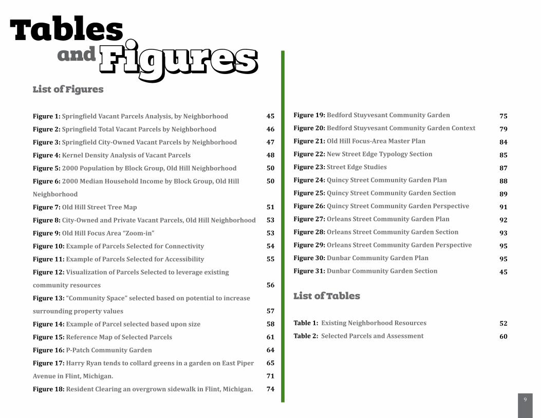
Tablesand Figures
List of Figures
Figure 1: Springfield Vacant Parcels Analysis, by Neighborhood
Figure 2: Springfield Total Vacant Parcels by Neighborhood
Figure 3: Springfield City-Owned Vacant Parcels by Neighborhood
Figure 4: Kernel Density Analysis of Vacant Parcels
Figure 5: 2000 Population by Block Group, Old Hill Neighborhood
Figure 6: 2000 Median Household Income by Block Group, Old Hill
Neighborhood
Figure 7: Old Hill Street Tree Map
Figure 8: City-Owned and Private Vacant Parcels, Old Hill Neighborhood
Figure 9: Old Hill Focus Area “Zoom-in”
Figure 10: Example of Parcels Selected for Connectivity
Figure 11: Example of Parcels Selected for Accessibility
Figure 12: Visualization of Parcels Selected to leverage existing
community resources
Figure 13: “Community Space” selected based on potential to increase
surrounding property values
Figure 14: Example of Parcel selected based upon size
Figure 15: Reference Map of Selected Parcels
Figure 16: P-Patch Community Garden
Figure 17: Harry Ryan tends to collard greens in a garden on East Piper
Avenue in Flint, Michigan.
Figure 18: Resident Clearing an overgrown sidewalk in Flint, Michigan.
Figure 19: Bedford Stuyvesant Community Garden
Figure 20: Bedford Stuyvesant Community Garden Context
Figure 21: Old Hill Focus-Area Master Plan
Figure 22: New Street Edge Typology Section
Figure 23: Street Edge Studies
Figure 24: Quincy Street Community Garden Plan
Figure 25: Quincy Street Community Garden Section
Figure 26: Quincy Street Community Garden Perspective
Figure 27: Orleans Street Community Garden Plan
Figure 28: Orleans Street Community Garden Section
Figure 29: Orleans Street Community Garden Perspective
Figure 30: Dunbar Community Garden Plan
Figure 31: Dunbar Community Garden Section
List of Tables
Table 1: Existing Neighborhood Resources
Table 2: Selected Parcels and Assessment
45
46
47
48
50
50
51
53
53
54
55
56
57
58
61
64
65
71
74
75
79
84
85
87
88
89
91
92
93
95
95
45
52
60
10
1. Introduction
Vacancy, as an actor in our urban landscapes, is growing in
importance. As the realities of post-industrialism are making
themselves ever clearer in many cities across the country, issues
of vacancy are becoming of paramount concern. After all, if the
density and centrality characteristic of traditional urban form
are the result of forces of production and industrialization, then
forces of de-industrialization could be said to have a set of equal,
yet opposite results. For many post-industrial cities, these results
include job and population losses, and an increase in vacant
and abandoned land. This situation has only been worsened
by the recent foreclosure crisis in the United States, resulting
in the vacancy and abandonment of more and more inner-city
properties.
An increase in vacancy is cause for concern, as it has been
shown to contribute to urban blight in the form of deleterious
neighborhood effects such as increased crime rates, decreased
property values, and the deterrence of future development
(Immergluck & Smith 2006, Skogan 1990). These issues become
compounded the longer that vacancy persists in a neighborhood;
whereas short-term vacancy often signals a period of transition,
considered normal in many communities, long-term vacancy
“speaks overtly of failure: the inability to revitalize”(Corbin, 2003,
15). As such, vacancy in the urban landscape has become a hot-
button issue, and many post-industrial cities are struggling in the
search for strategies that can effectively address the problems
it is causing in their inner-city neighborhoods. One potential
strategy to consider in addressing the current conditions of urban
vacancy and abandonment is the incorporation of community
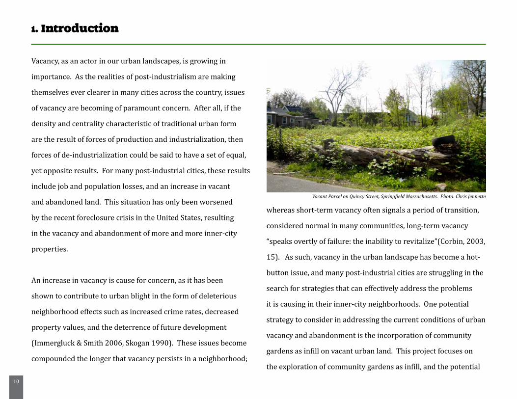
gardens as infill on vacant urban land. This project focuses on
the exploration of community gardens as infill, and the potential
Vacant Parcel on Quincy Street, Springfield Massachusetts. Photo: Chris Jennette
11
for gardens to contribute to community revitalization, provide a
valuable resource for residents, and to transform and enhance the
neighborhood aesthetic.
For decades, community gardens have been a staple in many
neighborhoods, providing city-dwellers with fresh produce, an
outlet for their green-thumbs, and a way to satisfy their desire for
local, independent modes of production. More recently, however,
small scale urban agriculture initiatives such as community
gardens are gaining recognition for a variety of reasons in
addition to their potential to provide neighborhoods with
affordable, nutritious, locally grown food. These types of gardens
can serve to increase property values, decrease crime rates, and
provide a foundation upon which to galvanize support for other
community initiatives (Voicu & Been, 2008). They are able to
unite communities, and in the process, to provide many more
services than simply food production.
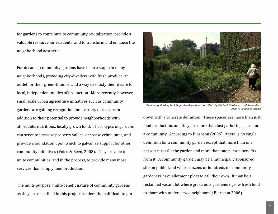
The multi-purpose, multi-benefit nature of community gardens
as they are described in this project renders them difficult to pin
down with a concrete definition. These spaces are more than just
food production, and they are more than just gathering space for
a community. According to Bjornson (2006), “there is no single
definition for a community garden except that more than one
person cares for the garden and more than one person benefits
from it. A community garden may be a municipally sponsored
site on public land where dozens or hundreds of community
gardeners have allotment plots to call their own. It may be a
reclaimed vacant lot where grassroots gardeners grow fresh food
to share with underserved neighbors” (Bjornson 2006).
Community Garden, Park Slope, Brooklyn New York. Photo by Flatbush Gardener, available under a Creative Commons License
12
This project seeks to explore the possibilities for community
gardening in Springfield, Massachusetts. Currently, community
gardening does not have a strong presence in the city. In fact, the
city’s 2008-2013 Open Space and Recovery Action Plan makes
no mention of community gardening whatsoever. This project
hopes to provide a framework for understanding the relationship
between vacancy and urban blight, as well as the many potential
benefits of urban agriculture in Springfield. It also seeks to
provide wealth of information related to the current inventory
of vacant land in Springfield, and a vision for the incorporation
of community gardens as infill on some of these parcels. It seeks
to demonstrate the potential of community gardens to combat
neighborhood problems caused by urban blight, and it seeks to
give these spaces a physical form that strengthens their identity,
improves their perceived value, and gives shape to the idea of
small scale urban agriculture in Springfield.
Through this project, I intend to examine a central research
question:
• In what ways do community gardens contribute to
neighborhood revitalization, and how might gardens be
implemented as an infill strategy for the city of Springfield?
It is my hope that this project can advocate for a paradigm shift in
our collective thinking about vacant urban land. Under this new
paradigm, vacancy is not seen as a death knell for neighborhoods,
but rather as the seed of a new urban form that supports both
the physical and social aspects of sustainability, acknowledges its
post-industrialist context, responds to demographic realities, and
promotes environmental justice while addressing the needs of its
resident community.
13
Project Goal and Objectives
It is the primary goal of this project to provide a strategy, vision,
and identity for the implementation of community gardens in
Springfield, Massachusetts.
In addition to this primary goal, research was carried out to
complete the following objectives:
• Achieve a thorough understanding of the potential of
community gardens in community revitalization
• Produce a valuable critical resource outlining the current
state of vacant and abandoned land within Springfield,
Massachusetts, and a set of criteria for the evaluation of its
suitability for use as community gardens
• Address the perceived incongruous relationship between
community gardens and an urban aesthetic
The above goal and objectives will be accomplished by:
• Conducting an in-depth literature review of existing
research on vacancy and urban blight, the positive impacts
of community garden projects, the use and perception of
community gardens, and barriers to their implementation, as
well as strategies to overcome those barriers.
• Obtaining vacancy data from the city of Springfield, and
providing an overview and spatial analysis of this data
through GIS mapping
• Selecting relevant case studies to explore possible models for
community gardening in Springfield, specifically regarding
implementation and design strategies
• Creating programmatic elements, and a series of typological
garden designs for selected parcels within a target
neighborhood in the city of Springfield
Additionally, in acknowledging the limitations of this project, it is
critical to note that the goals and objectives do not include:
• Demonstrating the economic feasibility of implementing
community garden projects throughout Springfield
• Locating and outlining sources of funding for these types of
projects
• Providing a comprehensive overview of urban agriculture or
community gardens as a viable food production system, or to
meet a current unmet food need in the city.
14
2. Current Conditions in Springfield
From 1960 to 1980 Springfield’s population declined from
175,000 to 152,000 residents, and underwent a drastic
demographic shift. During this period, Springfield’s black
population doubled, growing to just under 17 percent , and
the city’s hispanic population grew to nearly 10 percent.
Additionally, while the median family income was above that of
the nation overall in 1960, it had slipped to 86 percent of the
national average by 1980 (US Census Bureau). According to the
2005-2007 American Community Survey, Springfield’s current
median family income has fallen to approximately 65 percent
of the national average, with 28 percent of the population in
poverty. Currently, with a population of 150,000 residents, it is
the third largest city in Massachusetts.
Perceptions of crime are an issue for Springfield. According
to an Urban Land Institute report, the Federal Reserve Bank
of Boston’s Analysis of poverty in the city, and a report by the
University of Massachusetts’ Donahue Institute, improving public
safety within the city is of growing concern, even if perceptions
of criminal activity may in fact be worse than the reality (Federal
Reserve Bank of Boston 2009, 14). One explanation of this focus
on public safety is that “the distress in Springfield is very visible,
being concentrated in and near the downtown and along major
roadways” (Federal Reserve Bank of Boston 2009, 14).
In addition to perceptions of crime, Springfield also has a growing
vacancy problem, concentrated in and around three main
neighborhoods: Old Hill, Six Corners, and the South End (Fed.
Reserve System and Brookings Institution 2008, 140). According
to a 2008 report issued by the Federal Reserve System and the
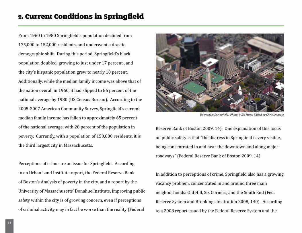
Downtown Springfield. Photo: MSN Maps, Edited by Chris Jennette
15
Brookings Institution:
“All three neighborhoods are characterized by vacant lots and abandoned or poorly maintained buildings. According to 2006 research by Hampden Hampshire Housing Partnership (HAP), the Old Hill neighborhood alone had 130 vacant or abandoned properties, accounting for almost 8 percent of the case study community’s residential units. These empty lots and abandoned or dilapidated buildings can have significant negative impacts on communities.” (Fed. Reserve System and Brookings Institution 2008, 140)
Included in the same report is a discussion of the issues that
were brought up by residents of these communities in interviews,
one of the most frequent being the “negatively reinforcing
relationship between unfavorable outside perceptions of the
community, the area’s limited ability to attract new investments,
and resident’s low morale” (Fed. Reserve System and Brookings
Institution 2008, 140). Moreover, residents felt that “outsiders”
held an inherently negative opinion of their neighborhoods, and
therefore the people that lived there, and that these negative
opinions were heavily contributing to a perceived lack of
investment in the area, and to the low morale among residents.
Residents felt that fear of crime was lowering their property
values and deterring commercial investment, as businesses may
not want to locate in what are now high-poverty, high-crime
areas. These outside perceptions were seen as a paramount
factor in the community’s inability to address its issues related
to poverty and crime (Fed. Reserve System and Brookings
Institution 2008, 141). The Literature Review Chapter of
this report will discuss the many ways in which community
gardens, as a potential infill strategy, can alleviate many of
the problems that are being experienced in Springfield’s most
disadvantaged neighborhoods. Though community gardening
is a strong potential strategy, there are a few challenges to
its implementation in the city of Springfield, also addressed
largely through the literature review, case studies, and design
development phases of the project. These issues are outlined
below.
Challenges to Community Gardening in Springfield:
Of particular concern for the City of Springfield is the need for
16
a comprehensive inventory and monitoring system of vacant
and abandoned land throughout the city. As of the time of this
project, the City of Springfield has only just begun to take a
proactive role in the management of its vacant land resources,
through the institution of an ordinance in 2009 requiring that
owners of vacant or abandoned properties register them with
the city. This ordinance was instated so that the properties are
on record and can be monitored to ensure maintenance and
adherence to various city codes. At the time of this writing, this
ordinance is still in its infancy, and no judgment can properly
made as to its effectiveness in any capacity.
In terms of challenges to community gardening in the city, this
is number one. Springfield needs a complete and continuously
updated register of its vacant land resources, so that decisions
can be made, and resources properly allocated for the assessment
and utilization of this vast resource. Without a comprehensive
monitoring and inventory system for vacant parcels, there is no
conceivable way that the city can take full advantage of the vast
potential held in these land resources.
This is going to be challenging for the city, however, as the
completion of an inventory, and its upkeep and maintenance
requires additional staffing that the city may not be able to
immediately afford. The City of Seattle (see case study chapter)
has an entire branch of staff dedicated to running programs for
community gardening within the city, helping interested parties
gain tenure on land, and maintaining a list that is kept current, so
that if an opportunity to establish a garden arises they are aware
of it. It is clear that Springfield and Seattle are very different
cities in nearly every respect, but even given the size difference,
it is hard to imagine Springfield keeping up adequately with the
monitoring of vacancy without additional resources.
Further, community gardening within Springfield is challenging
due to the lack of acknowledgement by the city that gardening
is an appropriate and productive use of urban space. There is
no acknowledgement of community gardening in the city’s 2008
Open Space Plan, and there is no definition or acknowledgement
of community gardening in the city’s zoning code. If there is to be
any progress made for urban gardening in the City of Springfield,
there needs to be acknowledgement and inclusion of gardening in
the city’s future plans. Additionally, the city must take a tolerant
stance on community gardening from an aesthetic point of view.
Traditionally, community gardens in the city have had a tendency
to look “messy” or unkempt, and this must not be mistaken for

17
dereliction or neglect. Given the potential for these spaces to
engage a community and create tangible positive change, there
needs to be acceptance that there is more to community gardens
than meets the eye. Likewise, the gardens themselves can be
adapted to fit more seamlessly into an urban aesthetic, creating
less tension. Several strategies for adapting these spaces and
mitigating potential aesthetic challenges are addressed and
discussed in both the Literature Review chapter of this report, as
well as the Design Development chapter.
18
3. Literature Review
3.I. The Impacts of Vacancy and Abandonment
Each day, across the United States, abandoned structures and
vacant lands sit derelict, haunting neighborhoods and blighting
the city landscape. Skogan (1992) asserts that this problem may
stem from a systematic “structural depression of central-city
housing markets, especially those tied to Northern industrial
‘Rust Belt’ economies” (Skogan, 1992, 41). He asserts that
the great influx of immigration that stretched urban housing
markets to their limits has subsided, and as jobs and people have
moved out of the inner city to the suburban ring, the market has
subsequently become depressed (Skogan, 1992, 41). This market
depression has led to a condition under which there are many
vacant and abandoned properties dotting our urban landscapes.
Additionally, the recent mortgage foreclosure crisis is a
contributing factor to the number of vacant and abandoned
properties in inner-cities. Immergluck and Smith (2006) assert
that while foreclosures do not create an immediate problem
in most middle and upper income neighborhoods that are
generally suburban in nature and where demand for housing
is relatively strong, they can trigger much more harmful effects
in neighborhoods with low to moderate income residents
(Immergluck and Smith 2006, 854). In neighborhoods with
relatively high median family income, foreclosed properties are
generally turned over relatively quickly resulting in only short
term vacancies. However, in lower income neighborhoods where
there is less demand, foreclosures are more likely to trigger
extended vacancies. These extended vacancies can often cause a
loss of confidence among neighboring property owners, or worse,
attract vandalism and crime. As these properties remain vacant
for longer periods of time, they are increasingly likely to become
“targets of vandalism, provide havens for criminal behavior, and
generally become sources of significant negative externalities
to neighboring residents” (Immergluck and Smith 2006, 854)
These negative externalities, or blighting effects, can take many
forms. They can trigger an increase in neighborhood crime,
lower neighboring property values, pose health hazards, isolate
residents and deter future investment.
19
Testing a hypothesis that the number of crimes on blocks
with abandoned buildings is higher than on those without
abandoned buildings, Spelman (1993) conducted research in
the low-income Austin, Texas neighborhood of Robertson Hill.
This study was conducted using a definition that qualified any
building that had been vacant for 3 months or longer, or was
deemed to be uninhabitable, as abandoned. The researchers
collected data for 35 residential blocks containing abandoned
buildings, as well as for 24 “control” blocks, where no abandoned
buildings were located. Inspection of the case blocks revealed
that approximately 41 percent of the abandoned residential
buildings could be accessed without the use of force, and that
of those buildings that could be accessed, 83 percent contained
some evidence of illegal use (Spelman, 1993). Overall, the study
concluded that the case blocks that contained unsecured vacant
buildings had 3.2 times as many drug calls to police, 1.8 times as
many theft calls, and twice the number of violent calls” as blocks
without vacant buildings (Spelman 1993, 481).
Immergluck and Smith (2006) also point out a link between
foreclosure rates and neighborhood crime. Using a variety of
data on foreclosures, neighborhood characteristics and crime
rates, they concluded that “a standard deviation increase in the
foreclosure rate (about 2.8 foreclosures for every 100 owner-
occupied properties in one year) corresponds to an increase
in neighborhood violent crime of approximately 6.7 percent”
(Immergluck and Smith 2006, 1).
Kelling and Wilson (1989) suggest that neighborhood crime and
abandoned or vacant buildings are connected through what is
referred to as the “broken window” theory. Broadly, the theory
suggests that if one broken window is left in disrepair, it acts
as an invitation for people to break more windows. According
to Kraut (1999), the underlying assumption behind this theory
is that where physical evidence suggests that there is no one
attending to the property, breaking more of the windows poses
relatively little risk (Kraut 1999, 4). This theory can also be
translated to a larger neighborhood context, suggesting that
the physical breakdown in the appearance of a neighborhood,
denoted by abandoned buildings or trash-filled vacant lots
20
can serve to indicate a lack of control over or concern about
neighborhood conditions, therefore inviting further destruction
and neglect. This is supported by Skogan (1992) who suggests
that “the presence of abandoned buildings may be the most
dramatic indicator of a neighborhood’s unhealthy condition.
Abandonment is a clear signal that in that area it is no longer
worth the effort to keep housing or businesses open” (Skogan
1992, 40).
According to a 2005 report completed for the National
Vacant Properties Campaign, in addition to the increases in
neighborhood crime, abandoned properties can also pose health
risks to their surrounding communities, as they are likely to
be accumulators of trash, dust, debris and pests. The report
states that they can also increase the incidence of diseases
such as asthma (National Vacant Properties Campaign 2005,
5). Additionally, Corburn et. al (2006) qualify vacant property
as a “potentially polluting land use” that may factor into
incidences of asthma in the urban environment (Corburn et.
al. 2006, 170) In addition to the potential health risks, vacant
and abandoned properties also threaten neighborhoods due
to their attractiveness to arsonists, and their vulnerability to
accidental fires. A 2005 publication by the National Vacant
Properties Campaign, titled “Vacant Properties: The True Costs
to Communities” cites that each year, the United States Fire
Administration reports over 12,000 fires in vacant structures.
The report states that “Fires are likely in vacant properties
because of poor maintenance, faulty wiring, and debris” (National
Vacant Properties Campaign 2005, 4). Additionally, more
than 70 percent of fires in vacant or abandoned buildings are
credited to arson or suspected arson (National Vacant Properties
Campaign 2005, 4). This represents not only a significant
resource expenditure for municipal governments, but it puts both
neighborhood residents and local firefighters at increased risk.
A 2001 study conducted by Temple University found that, in
addition to impacts on neighborhood crime and risks to resident
health, vacant properties also have a significant impact on the
value of surrounding homes and businesses. The study found
that homes within 150 feet of vacant or abandoned properties
suffered a net loss of $7,627 in value. Additionally, homes within
150 to 300 feet of vacant or abandoned properties experienced a
net loss of $6,819 and homes within 300 to 450 feet lost $3,542
in value. Overall, the study concluded that “all else being equal,
houses on blocks with abandonment sold for $6,715 less than
houses on blocks with no abandonment” (Temple University
21
2001, 22). Shuetz et al (2007) suggest that foreclosure plays a
role in property values as well, as their research concludes that
properties within close proximity of foreclosures do indeed sell
at a discounted rate (Shuetz et al 2007, 317). They additionally,
however, point to evidence of a threshold effect, wherein being
near a small number of foreclosed properties does not seem
to consistently lower property values, but being near a large
number of foreclosed properties greatly increases the price
discount (Shuetz et al 2007, 317).
These various “negative externalities” are only a few of the
potential impacts of vacancy and abandonment on urban
neighborhoods. In addition to their negative impacts on crime
rates, neighborhood health, and property values, vacant and
abandoned properties can also be a cause of damaging long-term
psychological effects on a neighborhood.
3.2. Vacancy, Abandonment, and Neighborhood Morale
Corbin (2003) suggests that there are “powerful, generalized
associations with vacancy in contemporary American culture”
that are most often negative, and suggest decline (Corbin 2003,
13). These associations may also contain a moral dimension, or
an aspect of judgment under which we associate vacancy with
idleness, waste, or laziness. According to Corbin, “signs such
as broken windows, weedy fields, or deteriorating fences are
readily understood in contemporary culture as human failure
made tangible in an anthropomorphized landscape” (Corbin
2003, 15). These signs are also often considered a component
of what some sociologists refer to as neighborhood physical
disorder. Skogan (1992) defines physical disorder as involving
“visual signs of negligence and unchecked decay” (Skogan 1992,
4). These signs of decay can include things such as trash filled or
overgrown vacant lots, abandoned or burned out buildings, and
broken windows or streetlights. Physical disorder, according to
Skogan is distinct from social disorder, which more often involves
illegal behavior on the part of individuals, such as prostitution,
public drinking, selling drugs on the street and other socially
unacceptable behaviors (Skogan, 1992, 4).
Broadly, Skogan proposes that disorder serves to undermine
the processes by which communities maintain social control
(Skogan 1992, 10). In those neighborhoods experiencing signs of
disorder, whether physical or social, where there are a number of
problems, and the residents don’t seem to be able to take control,
“the sense of territoriality among residents shrinks to include
22
only their own households; meanwhile, untended property is
fair game for plunder or destruction. Further, a neighborhood’s
reputation for tolerating disorder invites outside troublemakers...
where disorder is common and surveillance capacities are
minimal, criminals will feel their chances of being identified are
low, and may be confident that no one will intervene in their
affairs” (Skogan 1992, 10).
Disorder and crime, according to Skogan, have harsh impacts on
residents of the community. He states, “for residents, disorder
and crime lead first of all to withdrawal from the community.
Daily experience with disorderly conditions creates anxiety;
the prospect heightens fear. When communities finally become
unpleasant to live in, and encounters leave people feeling uneasy
and unsafe, many residents will try to leave” (Skogan 1992, 13).
Those residents who are unable to leave physically will withdraw
psychologically, either isolating themselves or seeking to find
friends and activity outside of the community. This withdrawal,
according to Skogan, “undermines any general sense of mutual
responsibility among area residents, and weakens informal
social control” (Skogan 1992, 13). It can also undermine people’s
participation in neighborhood affairs, and serve to foreshadow an
overall decline in the community’s capacity to organize on a social
or political level. This leads to a condition under which residents
are withdrawn, and somewhat demoralized by their inability to
counteract the mounting disorder in their communities.
Ross (2000) conducted a study based on 1995 survey data of
adults in Illinois to determine if neighborhood disadvantage
affects adult mental health. The study suggests that
individuals living in disadvantaged communities tend to suffer
psychologically as a result of their living conditions. Further,
Ross concludes that “the breakdown of social control and order
in one’s neighborhood is the major link between neighborhood
disadvantage and individual levels of depression” (Ross 2000,
184). She cites that disadvantaged neighborhoods “present
residents with observable signs that social control has broken
down; the streets are dirty and dangerous, buildings are run-
down and abandoned, graffiti and vandalism are common, people
hang out on the streets, drinking, using drugs, and creating
a sense of danger. Residents in these neighborhoods face a
threatening environment characterized by crime, incivility, and
harassment, which they find distressing” (Ross 2000, 185).
This section of the literature review has outlined the impacts of
vacancy and abandonment on neighborhoods and residents alike.
23
Vacant lots contribute to a condition under which neighborhoods
can fall into deeper despair and individuals can become more
and more isolated. In contrast, using these vacant spaces as
community gardens is a strategy that may be able to transform
communities. According to the city of Providence Urban
Agriculture Task Force, “by creating a garden, local residents and
organizations can transform under-used, blighted properties into
productive, safe and beautiful green spaces. The presence of a
garden beautifies and stabilizes a neighborhood, raises property
values and reduces local crime” (Urban Agriculture Task Force
2006, 10) The next section of the literature review will focus on
the ways in which community gardens can combat urban blight
and contribute to the well-being of their communities.
3.3. The Benefits of Community Gardens
While there is no silver bullet that can alleviate urban blight, a
growing body of work suggests that community gardening can
contribute to the revitalization of neighborhoods in a variety
of ways. Though academic research in the field is relatively
nascent, there is a considerable body of anecdotal evidence
that community gardening conveys many tangible benefits
to communities, from social and recreational opportunity, to
physical and mental health benefits (Malakoff, 1995; Bjornson,
2006; Pennsylvania Horticultural Society, 2006). Stocker and
Barnett (1998) provide a useful model of community gardens as
agents of change for local communities, suggesting that they act
in three distinct ways: the promotion of physical sustainability
through food-growing; the promotion of social sustainability
through fostering communal interaction; and the promotion of
economic sustainability through the use of community gardens
for skills development, education and training. Using Stocker and
Barnett’s structure as a springboard to view the literature, the
benefits of community gardening for local communities can be
further categorized into different modes:
- Improvement of access to food, and better nutrition (Dickinson, et al., 2003; Wakefield, 2007; Brown and Jameton, 2000)
- Improvement of mental and physical health (Dickinson, et al., 2003; Armstrong, 2000; Brown and Jameton, 2000; Wakefield, 2007)
- Increased opportunities for community development and
the growth of social capital (Schmelzkopf, 2002; Holland, 2004; Armstrong, 2000; Hancock, 2001; Wakefield, 2007, Pennsylvania Horticultural Society, 2006; Malakoff, 1995, Bjornson, 2006)
- Improvement of local ecology and benefits to local sustainability
(Deelstra and Girardet, 2000; Hancock, 2001; Schmelzkopf, 2002)
- Improvement of safety throughout local communities (Kuo, 2001;
24
Schmelzkopf, 1995)
Wakefield (2007) conducted a series of in-depth interviews with
community gardeners in South-east Toronto in an attempt to
gain qualitative insight into the many benefits that community
gardens can provide. According to the gardeners themselves, and
not surprisingly, one of the most important perceived benefits
was increased access to fresh, healthy food and the associated
savings with growing it themselves (Wakefield, 2007, 97).
Additionally, the ability to grow culturally appropriate foods
was seen as especially important to participants, as even those
foods that were available in local shops were often “exorbitantly
expensive” and lacking in freshness (Wakefield, 2007, 97).
Additionally, participants in the interviews indicated that another
important benefit to gardening locally was its impact on their
physical health, through the provision of an outlet for both
physical exercise and better nutrition. One respondent noted
that for them, community gardening was “a form of exercise,
relaxation... getting away... from the TV...a way to produce
something with your hands” (Wakefield, 2007, 97) This idea of
“getting away” whether it is from the TV, or from the tensions
of city life seems to be another major benefit of community
gardens for respondents in the 2007 study, who seemed to find
the simple opportunity to interact with nature to be relaxing and
calming. The community gardens that these people worked in
were viewed to be spaces of calm and retreat within their densely
populated urban contexts (Wakefield, 2007, 97).
Brown and Jameton (2000) reference the physical benefits
of gardening, citing that horticultural therapists have “long
recognized the benefits from physical exercise in gardening...
from fine motor involvement when cutting flower stems, for
instance, to aerobic gross motor tasks such as turning a compost
pile” (Brown and Jameton 2000, 28). Further, they characterize
community gardens in the urban landscape as places that create
a respite from the tensions inherent in city life, so powerful as
to even have a relaxing effect on passersby (Brown and Jameton
2000, 28). This is supported by Brogan and James (1980), whose
work studied the ecological relationship between aspects of the
physical environment and social problems in an Atlanta, Georgia
neighborhood. The study examined the relationship of physical
indicators such as the presence of dumps, parks, crosswalks,
trees and gardens to social problems such as mental illness,
juvenile delinquency, and even violent death. Vegetable gardens
were featured significantly in the study, as one of the positive
25
community influences working against social problems (Brogan
and James 1980).
In addition to the physical and mental health benefits inherent in
gardens, Wakefield (2007) points out that community gardening
also has tangible benefits on what is referred to as “community
health”. That is, the results of Wakefield’s series of interviews
suggest that,“community gardens are seen to benefit the
community as a whole, by improving relationships among people,
increasing community pride and in some cases by serving as an
impetus for broader community improvement and mobilization”
(Wakefield 2007, 98). Gardens can serve to activate a vulnerable,
isolated community by providing a safe place for socialization
and interaction. They can foster a sense of belonging, and serve
to lessen the isolation felt by residents. Perhaps Charles Lewis
(as cited in Malakoff, 1995) put it best: “A community activity
such as gardening can be used to break the isolation, creating
a sense of neighborliness among residents. Until this happens,
there is no community, but rather separate people who happen
to live in the same place” (Malakoff 1995, 19). The neighborhood
unity and sense of belonging that community gardens create
can be independent of individual backgrounds, cultures, and
lifestyles in some communities. In others, it can serve as a
source of pride, and a vehicle for strengthening a shared cultural
identity (Pennsylvania Horticultural Society, 2006). The ability
for community gardens to provide a social outlet for residents
is especially important in disadvantaged neighborhoods, where
residents are far more likely to isolate themselves and see a
breakdown in neighborhood control.
Armstrong (2000) examines a variety of the potential
social benefits of community gardens on disadvantaged
neighborhoods in upstate New York. She concludes that
community gardens “seemed to facilitate improved social
networks and organizational capacity in the communities
in which they were located, especially in lower income and
minority neighborhoods. Gardens seemed to provide a symbolic
focus for some neighborhoods, which increased neighborhood
pride and the aesthetic maintenance of neighborhoods. Also,
many of the community gardens lead to further neighborhood
organizing by providing a physical location for residents to meet
each other, socialize, and learn about other organizations and
activities/issues in their local community” (Armstrong 2000,
325). Furthermore, Armstrong suggests that community gardens
located in disadvantaged or low-income neighborhoods are about
four times more likely to lead to other issues being addressed
26
within the neighborhood (Armstrong 2000, 325). Garden
coordinators interviewed during the study indicated instances of
additional community organizing that were made possible by the
presence of the garden, including neighborhood beautification,
tree plantings, crime-watch efforts, and a number of other
initiatives (Armstrong 2000, 324).
These findings are supported by Brown and Jameton (2000)
who conclude that community gardens have the potential
to create opportunities for community organization and the
creation of social capital. They suggest that the effort that is
needed to develop and sustain these gardens requires dedication,
complicated knowledge, and skills. When a community engages
with the process of establishing and maintaining a community
garden, they are making a powerful statement about their desire
to transform their landscape, claim a sense of place and pride,
and empower community participation and social change (Brown
and Jameton 2000, 29). Additionally, Glover (2003) states
that “By converting decaying urban spaces into ornamental or
vegetable gardens, or both, residents transform neighborhood
liabilities, namely abandoned dilapidated lots into tangible (e.g.
fresh produce, beautification, sitting gardens for recreation) and
intangible assets. In the context of urban revitalization, therefore,
these “assets” reflect an effort for positive neighborhood change”
(Glover 2003, 191-192).
Hancock (2001) examines the impact of community gardens
on the creation of social, human, natural and economic capital
in neighborhoods. The sum of these types of capital is what
Hancock refers to as “community capital”, an indicator of the
health of a community based on the relationship between its
economy, ecology, population and social networks. According
to Hancock, community gardening is a way that neighborhoods
can simultaneously grow each one of these types of capital,
thus increasing their overall health. He states that “community
gardens build social capital... they are created and managed by
the community itself and depend upon a cohesive social network
to organize and manage the gardens” (Hancock 2001, 279).
Additionally, he suggests that community gardens are especially
suited to the diversity that characterizes many inner-city
neighborhoods, “while each family tends to grow the foods with
which it is familiar, before long they begin to ask about and learn
about the vegetables that other cultures grow and use. It may not
be long before this progresses to sharing recipes, sharing foods,
establishing community dinners and in various ways building
social networks across ethno-racial divides” (Hancock 2001,
27
279). He also suggests that community gardens build human
capital, defined as “ healthy, well educated, skilled, innovative
and creative people who are engaged in their communities and
participate in governance” (Hancock 2001, 276).
Human capital is built as residents engage in the garden, and
learn about other cultures, food production, food preparation and
so on. He further suggests that human capital is built through
the inter-generational potential that is inherent in community
gardens, wherein the older gardeners teach the younger and vice-
versa (Hancock 2001, 279). Economically, it is suggested that
these types of gardens provide a benefit for their communities
by helping to reduce the cost of living for residents by providing
a relatively inexpensive source of fresh, healthy food, thereby
increasing disposable income. Additionally, he poses that in
certain situations these gardens may eventually evolve into
sources of income for the gardeners, citing an example in New
York where gardeners have started to grow fresh herbs for local
restaurants (Hancock 2001, 279).
Finally, Hancock suggests that community gardens aid in the
creation of “natural capital” which pertains to ecosystem health,
environmental quality, conservation of habitat, etc. (Hancock
2001, 276). He states that “community gardens provide an oasis
of greenery, flowers and even habitat for various insects and
birds” (Hancock 2001, 279). Additionally, he cites the sustainable
benefits of growing food locally, such as opportunities to compost
(reducing waste production in the community), and avoidance
of the ecological costs associated with shipping food from long
distances.
Deelstra and Girardet (2000) further discuss the ecological
benefits of urban agriculture and local food production,
stating that urban farming has the potential to improve urban
microclimates, conserve soils, minimize waste and improve
nutrient recycling, as well as to improve water management,
biodiversity, and the environmental awareness of city inhabitants
(Deelstra and Girardet 2000, 47). They also suggest that urban
agriculture can “contribute to the comfort of citizens” through its
provision of additional green space and its ability to transform
neglected spaces within the city (Deelstra and Girardet 2000, 48).
This focus on environmental benefits is also echoed in Brown and
Jameton (2000):
“The transformation of an unsightly and dangerous lot into an environmentally healthy and beautiful garden can reap enormous benefits for an inner-city
28
community. Gardens increase a city’s biodiversity with plant variety and by attracting beneficial soil microorganisms, insects, birds, reptiles, and animals. Urban green spaces can also play a role in species preservation for birds and butterflies by providing food, resting spaces, and protection along migratory flight paths. Furthermore, urban agriculture can reduce soil erosion and ground water contamination when appropriate safeguards and practices are used. And plants not only absorb soil contaminants through their root systems, they also can reduce air pollution by absorbing pollutants through their foliage.” (Brown and Jameton 2000, 32)
Finally, in addition to the aforementioned benefits, Kuo (2001)
suggests that the mere presence of vegetation in the urban
environment can help to reduce crime rates. In a 2001 study of
crime rates for 98 apartment buildings in inner city Chicago, it
was found that the greener a building’s surroundings, the fewer
crimes were reported. This pattern was found to hold true for
both property crimes and violent crimes, even after accounting
for variables such as building height, number of apartments
per building, vacancy rate, and number of occupied units (Kuo
2001, 343). Kuo suggests that vegetation actually inhibits
crime through two distinct mechanisms: increasing surveillance
and mitigating psychological precursors to violence (through
the aforementioned calming effects, and its ability to combat
mental fatigue)(Kuo 2001, 346). According to Kuo, “there is
some evidence to suggest that in inner-city neighborhoods,
vegetation might introduce more eyes on the street by increasing
residents’ use of neighborhood outdoor spaces” (Kuo 2001,
346). Furthermore, and perhaps just as important as increased
surveillance is the concept of implied surveillance. Territorial
markers suggesting that surveillance is likely, such as landscaped
or maintained vegetation in the urban environment, have been
“empirically linked to lower rates of incivilities and crime” (Kuo
2001, 346).
The social, cultural, environmental, and economic benefits
outlined in this literature review no doubt aid in a compelling
case for the importance of community gardens in our urban
landscape. They can serve a key role in creating life-changing
opportunities for neighborhood residents, and they can help to
make neighborhoods more beautiful, sustainable, economically
healthy, and safe. The assertion that community gardens are a
viable and logical component of urban neighborhoods, however,
requires some discussion of the relevant literature available on
the use of these spaces once created, how they are perceived by
both residents and city officials alike, and the importance of their
aesthetic appearance as part of the urban fabric in our cities.
29
3.4. Use, Perception, and the Importance of Aesthetics
Community gardens are an unique and productive use of urban
space. However, despite the wide range of benefits that they offer
communities, gardens are often seen as complimentary, rather
than necessary parts of a neighborhood’s open space system.
Traditional forms of open space, such as city parks are often
given priority in the development of urban open space, but there
is some evidence to suggest that community gardens play an
unique role in providing recreational opportunity to a user base
that is currently underserved by traditional open spaces such
as parks and playgrounds (Francis 1987, 107). In order to gain
an understanding of the different uses of, and different attitudes
toward both traditional and non-traditional forms of open space,
Francis (1987) conducted a comparative study of a public park
and adjacent community gardens in Sacramento, California. The
stated purpose of the study was to “determine the roles ‘garden’
and ‘park’ play in city life” (Francis, 1987, 101).
Regarding use of the spaces, patterns observed over a seven
month period, as well as interviews with users revealed some
key differences between the park and community gardens. While
users of the park were generally younger, with children and
teenagers comprising nearly one third, most garden users were
over the age of thirty. Additionally, while almost all of the park
users were found to frequent other parks throughout the city,
more than three quarters of the garden users were not users of
city parks at all. Further, garden users travelled a longer distance
to use their chosen space, and spent more time there than park
users, with a majority of users spending more than one hour in
the garden, and one one third spending more than two hours,
compared to a majority of park users spending less than one hour
in the park (Francis 1987, 107).
Users of both spaces were interviewed over a two year period,
and asked to state their views regarding the space that they
were using (park or garden), as well as the adjacent space. They
were then asked a series of questions about their attitudes
toward both of the spaces. As stated by Francis, “When asked
to, ‘describe’ the park, people most frequently mentioned that
it ‘looks good’ or was ‘attractive,’ followed by the fact that it was
‘good for kids’”(Francis 1987, 105). Responses regarding the
community garden were a bit different, with the most frequently
used phrases by respondents being “‘friendly people/people
caring,’ ‘useful/economic,’ ‘good/excellent,’ and ‘a place that
brings people together’”(Francis 1987, 105). Compared to park
30
users, twice as many garden users used the words “like it/love
it” to describe their feelings toward the space that they were
using (Francis 1987, 105). Respondents were also asked to state
their dislikes of the “other” space (i.e. park users were asked
about the garden, and garden users were asked about the park).
Regarding elements most disliked about the park, garden users
most frequently mentioned “‘transients,’ surrounding traffic, that
the park was ‘ordinary,’ and the ‘neighborhood.’ For the gardens,
the [park user’s] most mentioned dislike was nothing, followed
by maintenance, and that it was ‘too small’” (Francis 1987, 106).
Overall, the results of the interviews characterized the gardens as
more friendly, more beautiful, equally accessible, and safer than
the park (Francis, 1987). Perhaps more tellingly, Francis states
that “one striking finding of the garden user sample was that
about one quarter said their ideal open space ‘would be similar to
this place,’ while very few park users said it would be similar to
the park” (Francis 1987, 108).
Compared to the garden and park users, governmental officials
who were interviewed had different opinions of the community
gardens. For these officials, the primary benefit of the community
gardens was that “the property is maintained versus leaving it
vacant” (Francis 1987, 107). Francis also states that “one official
remarked that he felt ‘the neighborhood’s reaction to the garden’s
was mostly negative.’ Another viewed the park as a better ‘visual
focus’ for the neighborhood than the gardens” (Francis 1987,
107). Additionally, whereas a majority of users and non-users
interviewed felt that the gardens should be made permanent,
the officials unanimously discounted the value of the gardens as
permanent open space in the city, citing the value of the property
for potential redevelopment (Francis 1987, 107).
Thus, the study seems to suggest an apparent disconnect between
the officials who are in charge of providing open space within the
city, and the residents who either use it or see it on a daily basis.
As stated by Francis:
“Both park and garden users and non-users placed
value on the importance of the gardens, while city
officials saw them primarily as a temporary solution
to the problem of vacant land. For example, both
users and non-users saw the fence around the
gardens as necessary to their success but did not see
it as restricting their access, while city officials saw
the fence as a barrier to public use.” (Francis 1987,
110)
31
This disconnect is possibly explained by a body of theory
that frames the complex relationship between aesthetics and
perception. As Appleyard (1979) describes, the world around us
is filled with social symbols capable of communicating a variety
of meanings, which people perceive and interpret, if even on
a subconscious level (Appleyard 1979). Joan Nassauer (citing
Kevin Lynch’s 1971 “Site Planning”) states perhaps more clearly,
“human inhabited landscapes operate as ecological systems,
but they also operate as communication systems” (Nassauer
1995, 162). The aesthetics of a place inherently communicate
to the observer something about the nature of it, as well as who
may inhabit or care for it. As Nassauer states, “the landscapes
of city dweller’s homes, neighborhoods, parks, roadsides, and
businesses are public portraits of themselves” (Nassauer 1995,
162). As such, people desire for their landscapes to put forth the
right symbols, to communicate the correct meaning. According
to Nassauer, “In the everyday landscape of North America,
the recognizable system of form typically is characterized by
neatness and order. While many observers have associated
neatness and order with the human desire to control or dominate
the landscape, these characteristics are more validly interpreted
as signs of sociable human intention. Neatness cannot be
mistaken for untended nature; it means a person has been in a
place and returns frequently. It means a place is under the care of
a person” (Nassauer 1995, 162).
Regarding community gardens, one of the stated concerns of city
officials as cited in Francis’ (1987) study is that their appearance
is often lacking aesthetic appeal, or that they can become messy
and have problems with maintenance (Francis 1987). This is
perhaps due to the nature of growing plants that have a tendency
to look messy, and that might appear to be unkempt, despite
their actual maintenance (Francis 1987, 110). Officials also
perceive the fences around gardens as a barrier to public use,
different than the common perception of resident users and
non-users alike, who perceive the spaces to be quite accessible
(Francis 1987, 110). Though these spaces are indeed cared for,
and treasured by their owners, their appearance can serve as
a symbol that is easily misinterpreted, perhaps aiding in their
perceived lack of value relative to other forms of development.
Nassauer, however, suggests that there are ways to mitigate the
disconnect between function and perception. She proposes that
“cues to care”, or legible symbols of human intention, are key to
getting people to accept a more novel landscape type within any
particular matrix, stating “cues to care make the novel familiar
and associate ecosystems that may look messy with unmistakable
32
indications that the landscape is part of a larger intended
pattern” (Nassauer 1995, 167). She goes on to state that “cues
may vary from region to region and among ethnic groups, but
an underlying principle across cultures and regions is that these
cues express care of the landscape... In some places, care will not
look neat in the way we might recognize it in a North American
suburb. However, cues to care can be observed in the vernacular
landscapes of many communities” (Nassauer 1995, 167).
Certain cues to care, such as lawn-mowing and linear planting
design, emerged in the midwestern suburbs that Nassauer
studied, but others might emerge in a more urban vernacular.
Though academic research on gardens in the urban environment
relative to aesthetic appearance is quite sparse, the arguments
presented in this literature review make it clear that the design
of community gardens can serve a very important role in their
perception, valuation, and success. Apart from simply their
design, however, there are a number of major obstacles that
community gardens face in terms of implementation and success.
3.5. Major Obstacles and Potential Strategies
The preceding sections of this literature review have outlined
how community gardens have great potential to act as amenities
in urban neighborhoods, and to increase quality of life for
residents in many different respects. Despite their numerous
benefits, however, these spaces are not easy to implement and
maintain. Community gardens face many obstacles to success,
a few of which will be discussed in this section of the literature
review, along with potential strategies that can be used to
overcome them. Specific, place based strategies will not be
discussed herein, but will instead be addressed in the case-study
section of this project.
By far the most imposing obstacle in terms community garden
implementation and success is the often tenuous relationship
between gardens and the land on which they reside. Obtaining
and retaining land for community gardens is the greatest
challenge to implementation and success. As Kaethler (2006)
points out, across North America, many cities are finding
creative ways to use vacant land for urban agriculture initiatives,
including community gardens (Kaethler 2006, 21). Though these
parcels are seemingly well suited for use as community gardens,
there is often a great degree of difficulty that is faced in obtaining
the land, as potentially re-developable urban parcels come at
quite a price (Kaethler 2006, 21). The conflict between vacancy
33
or underuse, and future redevelopment is a key factor in the
difficulty of community gardens obtaining land, and eventually
obtaining permanent tenure -- due to the nature of their urban
environments and the municipal thrust for redevelopment, cities
are often unwilling to designate vacant land to a permanent use
that is more perhaps more socially than economically productive.
Thus, even when leases are granted they are often for short
term periods, giving relatively little stability to the spaces (Hall
1996). Mougeot (2006) suggests that users are unlikely to invest
the necessary amount of time, energy, and resources to make a
project successful when they feel that the clock is ticking and the
ground could literally be pulled out from beneath their feet. This
is a point of view also expressed by Hall (1996), who addresses
the issue of tenure, specifically in terms of short term agreements.
She claims that short term agreements severely limit the ways
in which the gardens can develop. After all, if a garden is only
guaranteed tenure for a period of less than five years, there is no
incentive to plant, for instance, fruit trees (Hall 1996).
There are, however, a few innovative ways that cities can
approach the challenge of obtaining and protecting land for
community gardens. Mougeot (2006) states that one of the key
components in securing land for community gardens is knowing
exactly how much land is available, and where it is (Mougeot
2006, 50). He suggests that “perhaps the first lesson, then, is
the importance of taking stock -- creating an inventory of all the
land in the city that could be used for some form of production,
whether permanently or temporarily” (Mougeot 2006, 50).
Schukoske (2000), in an article published by the American
Community Gardening Association, suggests that this assessment
is only part of what municipalities should be doing to support
community gardens, stating that “localities must assess their
context, such as the number, size and location of vacant lots, the
climate, gardener’s interests in food production and marketing,
the real estate market, and the potentially interested group of
gardeners” (Schukoske 2000, 1). She also suggests that in some
older cities, support for community gardens can be viewed
as part of a larger effort directed toward the rehabilitation
of abandoned or tax-delinquent parcels, putting them back
into productive use as opposed to simply letting them remain
idle (Schukoske 2000, 1). Further, she outlines a few “best
practices” that local governments can implement in order to
support community gardens, including the allocation of staff for
inventorying vacant public and private parcels in low-income
neighborhood, and making the information easily accessible
to the public (Schukoske 2000, 1). Regarding the inventorying
34
process, Mougeot (2006) states:
“municipal governments that have mapped their
city’s open spaces are amazed by how much space
sits idle at any given time. There is usually much
more happening in your city than meets the eye,
even a bird’s eye. Unused urban space is a wasted
opportunity -- an asset denied to a community’s
well-being and a brake on the city’s development.”
(Mougeot 2006, 64)
Contracting with private landowners for leases on vacant lots
is also recommended by Schukoske (2000), as well as the
authorization of “use of municipal land for minimum terms long
enough to elicit commitment by gardeners, such as five years, and
provide for permanent dedication to the parks department after
five years of continuous use as a community garden” (Schukoske
2000, 1) Finally, she goes on to suggest that support from local
governments might even go so far as to aid in preparing the
vacant lots, providing technical assistance, signage and tools, and
giving the gardens free access to water (Schukoske 2000, 1).
In addition to helping community gardens obtain land tenure,
there are other actions that can be taken by cities in support
of urban agriculture and community gardens, through policy
and the amendment of prohibitive zoning bylaws, as well as
the incorporation of community gardens as a valid land use.
Mougeot (2006) states that despite its numerous benefits,
urban agriculture often “suffers from an image problem and is
seldom recognized as a valid land use category” (Mougeot 2006,
64). Librizzi (1999) suggests that developing a specific zoning
category tailored to community gardens is a key method for
ensuring their long-term success and protection (Librizzi 1999,
3). As an example of this type of strategy, Librizzi cites the City
of Boston’s use of flexible open space zoning to accommodate
and protect community gardens. The zoning code allows for
parcels designated as open space under the cities zoning code
to be further designated as a specific subdistrict, one of which is
a community garden subdistrict. Defined by the city of Boston,
“Community Garden Open Space Subdistricts shall consist of land
appropriate for and limited to the cultivation of herbs, fruits,
flowers, or vegetables, including the cultivation and tillage of soil
and the production, cultivation, growing, and harvesting of any
agricultural, floricultural, or horticultural commodity; such land
may include public vacant land” (Librizzi 1999, 4). According to
Enns et al., local governments should “identify suitable sites for
community gardens and incorporate them into existing zoning
35
bylaws” (Enns et al. 2008, 6). Enns uses the district of Saanich
on Vancouver Island in British Columbia as an example of this
strategy, stating “Saanich amended its zoning bylaw to allow
community gardens as a permitted land use in all zones, except
natural parks or environmental conservation areas” (Enns et al.
2008, 8). Enns also proposes that partnerships are key to the
process of developing successful community gardens, and that
local governments can engage in the promotion and protection of
gardens though supporting community groups and non-profits in
their efforts to establish garden spaces.
One very successful example of the power of partnerships is
the City of Seattle’s cooperation with the P-Patch trust, a non-
profit organization working to develop community gardens
in the city. In a bold step, the City of Seattle passed resolution
28610 in 1992, declaring support for the P-Patch community
garden program and recommending that the program be
incorporated into the city’s comprehensive plan (City of Seattle,
1992). Further, the resolution stipulated that “any appropriate
ordinances be strengthened to encourage, preserve and protect
community gardening”, “The City of Seattle will include the
P-Patch Program in the evaluation of priority use of city surplus
property”, the city “will attempt to provide budgetary support
for the management of the P-Patch Program”, and that the city
“will promote inter-agency and intergovernmental cooperation
among agencies such as the Parks Department, the Engineering
Department, the Housing Authority, the School District Metro,
the Port Authority, the Water Department, City Light, and the
Department of Transportation to expand opportunities for
community gardening” (City of Seattle, 1992).
Other instances of municipal support for garden programs
are numerous, and include cities such as Vancouver, British
Columbia and Providence, Rhode Island among others. The
City of Vancouver Board of Parks and Recreation developed
a community garden policy in 2005 that states “the Board
recognizes community gardening as a valuable recreation activity
that can contribute to community development, environmental
awareness, positive social interaction and community education.
The Board will collaborate with interested groups in assisting
the development of community gardens (Vancouver Parks Board,
2005). Specifically, the policy states that the board plans to
support development of community gardens through providing
access to information on the processes of development and
successful operation, assisting groups in the search for suitable
land, including city-owned, governmental, and privately owned
36
parcels, assisting in the creation of agreements with owners of
the parcels that are chosen, and assisting in the development of
environmental education programs in the community (City of
Vancouver, 2005).
Providence, Rhode Island is another municipality looking at
ways of providing a strong system of support for community
gardens. The Providence Urban Agriculture Task Force, in
a 2006 publication titled “Urban Agriculture in Providence:
Growing Our Community by Growing Good Food” states that
“zoning and comprehensive planning both arose in response to
the ills of urbanization. Originally, these tools were focused on
keeping incompatible uses apart, principally keeping dangerous
factories out of residential neighborhoods. Now these tools are
used to better our neighborhoods by addressing citizen needs”
(Urban Agriculture Task Force 2006, 4). The article outlines the
importance of including support for urban agriculture into the
city’s zoning ordinance and comprehensive plan and suggests
that certain actions be taken, such as the removal of special use
permit requirements for community gardening in residential
neighborhoods, and the creation of a set of design standards for
community gardens that are “beneficial to both the neighborhood
and the garden’s users”(Urban Agriculture Task Force 2006, 4).
This literature review has outlined some of the available work
relative to the relationship between vacancy and blight in
our urban landscape, the current conditions in Springfield
Massachusetts, and the potential benefits that community
garden projects can contribute to communities. It has also
outlined a body of theory related to the perception of these
spaces, as well as research regarding their use and aesthetic
importance. Further, it has reviewed a number of challenges to
garden implementation and success, and looked at a few of the
ways in which communities and municipalities are attempting to
overcome these obstacles.
The literature review was used by the researcher as the primary
method for answering the following research questions:
- What is the the relationship between vacancy and urban blight?
- In what ways can community gardens address problems of
vacancy and urban blight?
- What are some ways that community gardening programs can
work in cities?
- What are some barriers to community gardening in cities?
- What roles do organizational structure, maintenance regimes,
and design aesthetic play in the success of community gardens?
37
The Literature Review uses material from a variety of sources
including peer reviewed journal articles, books, magazines,
websites, and student theses to examine issues related to
community gardens in our urban environment. It is divided into
a number of subsections, each of which addresses a different
aspect of the literature as pertaining to the research questions.
These sections are as follows:
Current Conditions in Springfield:
This section of the Literature Review draws from available
resources regarding the economic and demographic development
of the city of Springfield, with particular attention to reports
published by the Federal Reserve Bank of Boston. It outlines
the transition that the city underwent from a relatively
homogeneous, wealthy population in the 1960s to an increasingly
diverse population with a median income well below that of the
nation, and a high percentage of residents below the poverty line.
It also serves to outline some of the current issues seen in the
city, being a relatively high percentage of vacant urban land, and a
high perception of crime.
The Impacts of Vacancy and Abandonment:
This section introduces the issue of vacancy and its various
social and spatial implications for the urban environment.
This section includes an overview of the perception of vacant
spaces, as well as the problems that are associated with vacancy
such as increased crime, decreased property values, potential
health risks, and deterrence of future investment. It explores
the “broken window” theory, wherein neglect of the physical
environment conveys a powerful message that no one is
attending to the neighborhood, and therefore there is relatively
little risk of being caught in criminal activity (Kraut 1999, 4)
Vacancy, Abandonment, and Neighborhood Morale
Explores the relationship between the physical aspects of a
neighborhood and the morale, mental health, and community
capacity of its residents. It discusses the literature relating to
neighborhood decay and physical disorder, specifically regarding
their impact on the processes by which communities maintain
social control. It also addresses the issue of isolation that can
plague many neighborhoods experiencing signs of decay and
decline, and draws a clear connection between neighborhood
disadvantage and mental health.
38
Benefits of Community Gardens
This section explores the literature pertaining to the benefits
of community gardens. Though the academic research
regarding benefits of community gardens is relatively nascent,
there is a substantial body of anecdotal evidence suggesting
that community gardening conveys many tangible benefits to
communities, ranging from social and recreational opportunity
to physical and mental health benefits. Further, this section
organizes the benefits of community gardening into five
categories as present in the literature:
- Improvement of Access to food, and better nutrition
- Improvement of mental and physical health
- Increased opportunities for community development and the
growth of social capital
- Improvement of local ecology and benefits to local sustainability
- Improvement of safety throughout local communities.
Included in this section is a discussion of several qualitative
studies, specifically interviewing users of community garden
spaces, and the benefits that they perceive for themselves and
their fellow community members. Specifically important is the
discussion of community gardens as powerful tools to unite
community members, and direct their energies toward common
goals and improvement of their neighborhoods. One study
suggests that community gardens located in disadvantaged or
low-income neighborhoods are about four times more likely to
lead to other issues being addressed (Armstrong 2000, 325). It
also includes a discussion and acknowledgement of literature
relative to the impact of community gardens on the creation of
social, human, natural and economic capital in neighborhoods.
The sum total of these types of capital is referred to as
“community capital”, an indicator of the health of communities
based on the relationship between economy, ecology, population
and social networks.
Use, Perception, and the Importance of Aesthetics
This section addresses the literature relative to the use of
community garden spaces, as well as the importance of how
they are perceived, and how they relate to their environments
aesthetically. Though community gardens are an unique
and productive use of urban space, they are often seen as
complimentary, rather than necessary parts of a neighborhood’s
open space system. This is potentially because their use is
39
misunderstood, as the literature suggests that they serve a
demographic that is potentially underserved by traditional
forms of open space, such as urban parks. This section also
contains a discussion of the literature pertaining to qualitative
research on the perception of community garden spaces,
revealing a disconnect between perceptions of users, non-users,
and government officials. Finally, Section V acknowledges a
body of theory that frames the complex relationship between
aesthetics and perception , discussing the work of Appleyard,
and the potential of Joan Nassauer’s “cues to care” to mitigate the
disconnect between function and perception.
Major Obstacles and Potential Strategies
Discusses the many obstacles that stand in the way of success for
community garden projects, as well as some potential strategies
to overcome them. Issues relative to their implementation and
success are revealed through an examination of the literature.
Major obstacles include access to land and issues of tenure,
restrictive zoning, and lack of municipal support. Through an
examination of municipal ordinances, recommendations from
community gardening organizations, and existing research
projects, potential strategies for overcoming some of these
obstacles are also identified. This section of the literature review
also serves to inform the selection of research case studies for
this project, identifying models that could potentially work within
the context of Springfield, Massachusetts.
Based upon this literature review, a comprehensive methodology
was developed. The methodology is reviewed in the next chapter.
40
4. Methodology
To address the research questions of this project, four primary
methods were developed based largely upon research covered in
the literature review. Methods included:
- Geographic Information Systems Analysis and Assessment
- Case Study research
- Design Development and typological design scenarios
4.1. Geographic Information Systems Analysis and Assessment
Using data obtained from the City of Springfield, MassGIS, state
agencies and personal research, Geographic Information Systems
Analysis and Assessment was used by the researcher in order
to gain a deeper understanding of conditions on the ground in
Springfield, Massachusetts. Data analysis and mapping was
used to gain an understanding of the spatial composition of
vacant land, as well as its relationship to other resources such as
community gathering space, grocery stores and farmer’s markets,
schools, and existing parks and open space. Specifically, GIS
analysis and assessment was used in answering the following
research questions:
- Where is the vacant and abandoned land in Springfield?
- How does the arrangement of vacant and abandoned land relate
to other neighborhood resources, such as existing open space
and recreational opportunity?
GIS analysis and assessment allowed the researcher to choose
a target neighborhood based upon the concentration of vacant
land, and an assessed potential for using community gardens
to supplement gaps in the existing neighborhood fabric.
Spatial analysis and assessment also informs the placement
and nature of community garden spaces in the final design
recommendations. For instance, parcels nearest to schools are
assessed as being particularly conducive to potential gardens
containing educational or school gardening programs, and
parcels located a substantial distance from existing gathering
centers such as churches and libraries are potentially able to
accommodate a community garden designed and programmed as
a meeting space. Specific selection criteria, and a more in-depth
41
discussion of the GIS analysis and assessment may be found in
Chapter 5 of this document.
Data used in the GIS analysis and assessment includes:
- Vacant, city owned parcels- Vacant, privately owned parcels- City-wide parcels tied to Springfield Assessor’s data- Schools (College, High School, Elementary School, Daycare &
Pre-School)- Demographic Data from MassGIS
- Population- Poverty- Age- Race
- Churches and Community Centers- Libraries- Grocery Stores- Farmer’s Markets- Open Space
- Parks- Cemeteries- Playgrounds
- Public Transportation- Bus Stops, Bike Trails, Pedestrian Accessibility
Finally, Geographic Information Systems analysis and assessment
also informed the selection of research case studies through
revealing specific characteristics of spatial composition,
demographics, and community needs that could be matched to
existing neighborhood projects.
4.2. Case Study Research
Case study research was the primary vehicle for exploring the
following research questions, in light of their relevance to the
ongoing challenges in the city of Springfield:
- What potential municipal cooperation / planning strategy
models exist in other cities?
- What lessons can Springfield learn from these models?
- How are other cities and programs allowing community
members and organizations to access vacant lands?
- What does a successful and aesthetically pleasing community
garden look like?
A multiple case study approach allowed the researcher
42
the opportunity to explore community gardens and their
organization at three different scales, a large city network with
intense public/private partnerships, a smaller scale grassroots
initiative supported by an innovative municipally based approach,
and a site-scale project incorporating community feedback
and using recycled and unconventional materials. Case study
research is particularly relevant to this project, as it allows an
exploration of these projects across multiple scales, both spatial
and temporal, and for the researcher to see the results of the
strategies present in each of the three case studies. The results of
this case-study approach are discussed in Chapter 6.
4.3. Design Development
Based upon the GIS analysis and assessment, as well as the case
study research and literature review, the researcher embarked
upon a design process to take the evaluative products of this
project and generate a vision for the spatial arrangement, nature,
and design typology of community garden spaces within the
target neighborhood in Springfield, Massachusetts. The design
process included the synthesis of spatial factors identified and
assessed through the GIS analysis, cultural and historical factors
identified through the literature review, and successful strategies
identified through case study research. Specific strategies were
employed to resolve a number of the issues identified through
the literature review, as well. Results of this process, and the final
design recommendations will be discussed in Chapter 7.

43
44
5. GIS Analysis and Assessment
5.1. Target Neighborhood Selection
Before proceeding to in-depth analysis and assessment, a
preliminary categorization of Springfield’s 17 neighborhoods was
completed, based upon a number of important factors including
total percentage of vacant parcels, percentage of city owned
vacant parcels, median household income, and population figures.
Using vacant parcel data obtained from the City of Springfield’s
Housing Department, as well as 2010 Assessor’s data, the city’s
17 neighborhoods were categorized based upon their percentage
of vacant parcels, both publicly and privately owned. The
categorization was based upon a percentage of the total number
of parcels, not a percentage of the total land mass. This was done
to reveal a more accurate picture of on-the-ground conditions
in each one of the neighborhoods, as logic leads us to conclude
that a small inner-city neighborhood with a higher percentage
of vacant parcels is more likely to be experiencing deleterious
effects than a large neighborhood. Thinking about spatial
relationships between residents and vacant parcels, we can infer
that in a smaller neighborhood, there is physically less separation
between where people are living, and where the vacant parcels
can be found. The same logic leads us to the conclusion that
where there is a greater amount of land area, even though there
may be a higher amount of total vacant land, there may also
be greater separation between residents and vacant parcels.
Without the time to conduct an in-depth analysis of each
neighborhood to determine actual conditions, it was determined
by the researcher that the ratio of vacant parcels (both publicly
and privately owned) to the total number of parcels would be the
greatest determining factor regarding neighborhood need.
As can be seen in the neighborhood vacancy analysis, the two
neighborhoods with the greatest percent of vacant parcels are
the Pine Point Neighborhood and the Old Hill neighborhood.
The Pine Point neighborhood was found to have a total of
16.52% vacancy throughout, whereas the Old Hill neighborhood
had a total vacant parcel percentage of 13.98%. These two
neighborhoods had far and away the highest percentage of vacant
parcels; the Six Corners neighborhood, with the third highest
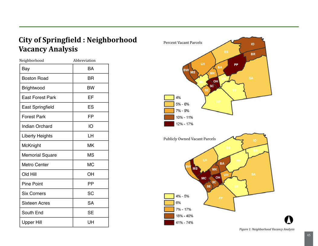
45
Bay BA
Boston Road BR
Brightwood BW
East Forest Park EF
East Springfield ES
Forest Park FP
Indian Orchard IO
Liberty Heights LH
McKnight MK
Memorial Square MS
Metro Center MC
Old Hill OH
Pine Point PP
Six Corners SC
Sixteen Acres SA
South End SE
Upper Hill UH
City of Springfield : Neighborhood Vacancy AnalysisNeighborhood Abbreviation
Percent Vacant Parcels
Publicly Owned Vacant Parcels
Figure 1: Neighborhood Vacancy Analysis
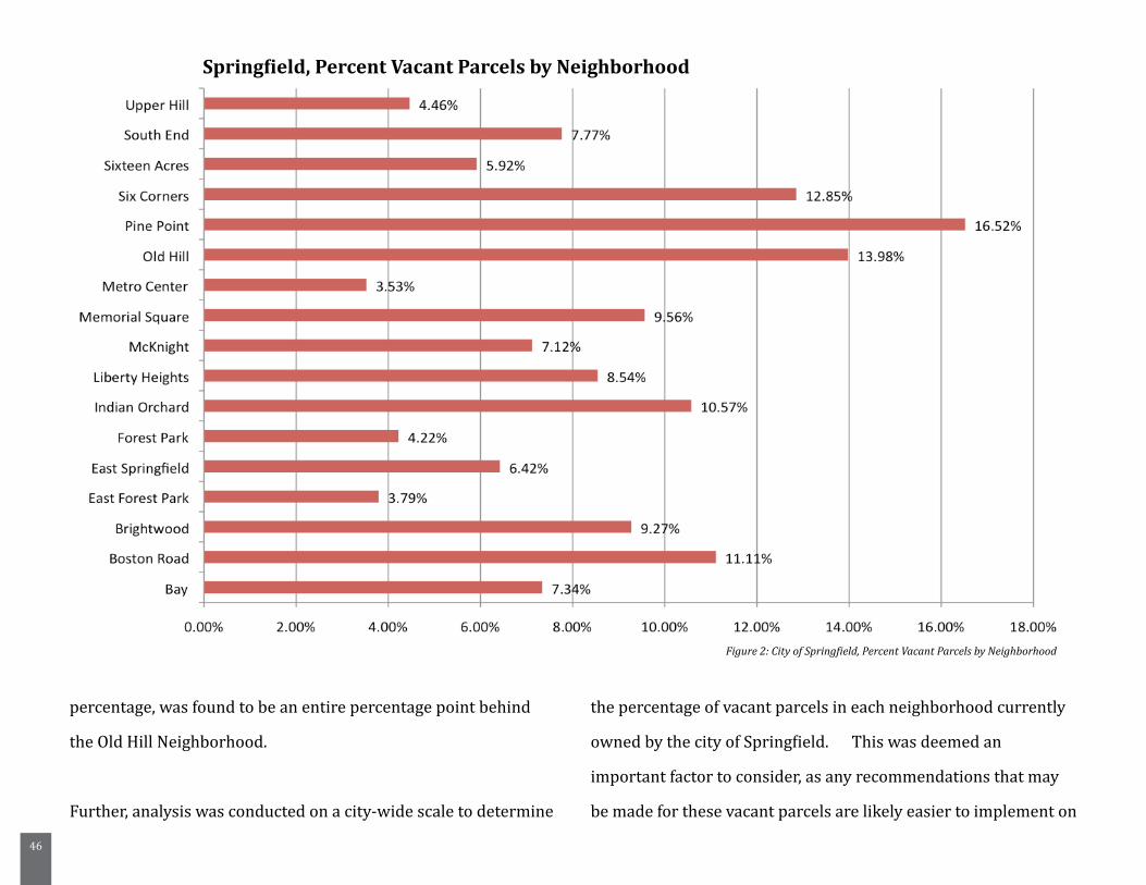
46
percentage, was found to be an entire percentage point behind
the Old Hill Neighborhood.
Further, analysis was conducted on a city-wide scale to determine
the percentage of vacant parcels in each neighborhood currently
owned by the city of Springfield. This was deemed an
important factor to consider, as any recommendations that may
be made for these vacant parcels are likely easier to implement on
Figure 2: City of Springfield, Percent Vacant Parcels by Neighborhood
Springfield, Percent Vacant Parcels by Neighborhood
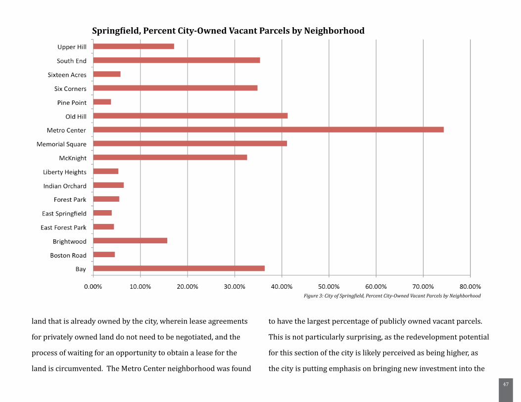
47
land that is already owned by the city, wherein lease agreements
for privately owned land do not need to be negotiated, and the
process of waiting for an opportunity to obtain a lease for the
land is circumvented. The Metro Center neighborhood was found
to have the largest percentage of publicly owned vacant parcels.
This is not particularly surprising, as the redevelopment potential
for this section of the city is likely perceived as being higher, as
the city is putting emphasis on bringing new investment into the
Figure 3: City of Springfield, Percent City-Owned Vacant Parcels by Neighborhood
Springfield, Percent City-Owned Vacant Parcels by Neighborhood
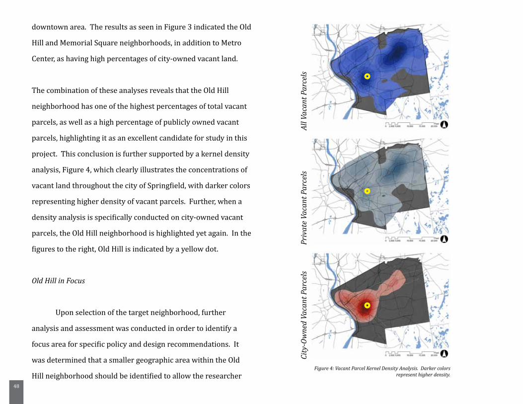
48
downtown area. The results as seen in Figure 3 indicated the Old
Hill and Memorial Square neighborhoods, in addition to Metro
Center, as having high percentages of city-owned vacant land.
The combination of these analyses reveals that the Old Hill
neighborhood has one of the highest percentages of total vacant
parcels, as well as a high percentage of publicly owned vacant
parcels, highlighting it as an excellent candidate for study in this
project. This conclusion is further supported by a kernel density
analysis, Figure 4, which clearly illustrates the concentrations of
vacant land throughout the city of Springfield, with darker colors
representing higher density of vacant parcels. Further, when a
density analysis is specifically conducted on city-owned vacant
parcels, the Old Hill neighborhood is highlighted yet again. In the
figures to the right, Old Hill is indicated by a yellow dot.
Old Hill in Focus
Upon selection of the target neighborhood, further
analysis and assessment was conducted in order to identify a
focus area for specific policy and design recommendations. It
was determined that a smaller geographic area within the Old
Hill neighborhood should be identified to allow the researcher Figure 4: Vacant Parcel Kernel Density Analysis. Darker colors
represent higher density.
All V
acan
t Par
cels
Priv
ate
Vaca
nt P
arce
lsCi
ty-O
wne
d Va
cant
Par
cels
49
to demonstrate a system of prioritization and categorization in
terms of the vacant parcel inventory. A number factors were
considered in the completion of GIS analysis and assessment
to identify this focus area within the Old Hill neighborhood,
including:
- Demographic factors, such as population and
income
- Existing open space within the neighborhood
- Spatial composition of vacant parcels, public
and privately owned (Potential for connectivity,
aggregation of parcels, etc.)
- Existing community inventory (grocery stores,
schools, colleges, libraries, churches, public
transportation) in terms of leverage potential and
community need
Each of these categories will be discussed below, in terms of their
impact on the neighborhood dynamic, and the selection of a focus
area within the larger neighborhood.
5.2. Demographic Factors
Demographically, the Old Hill Neighborhood has largely echoed
the trends that have happened in Springfield over the past forty
years, as discussed previously in the Literature Review chapter.
According to the United States Census Bureau, population
within the neighborhood decreased from 5,103 residents in
1990 to 4,557 residents in 2000, more than a 10% loss. The
neighborhood has also transitioned to a population that is
predominantly black and hispanic (only approximately 17% of
residents are white according to the 2000 United States Census).
Economically, the neighborhood is struggling. Compared to
the median household income for the city of Springfield overall
at $30,417, the Old Hill neighborhood is significantly lower at
approximately $20,905 in 1999 dollars. Both of these numbers,
of course, are well below the median for the United States in
2000, which was $41,994 (United States Census Bureau). Thus,
in a city that is struggling economically, the Old Hill neighborhood
stands out as being particularly disadvantaged.
In terms of housing occupancy within the neighborhood,
the census figures indicate that there is a significantly lower
percentage of owner occupancy, and higher renter occupancy
than in the city overall. According to the 2000 United
States Census, the Old Hill neighborhood was found to have
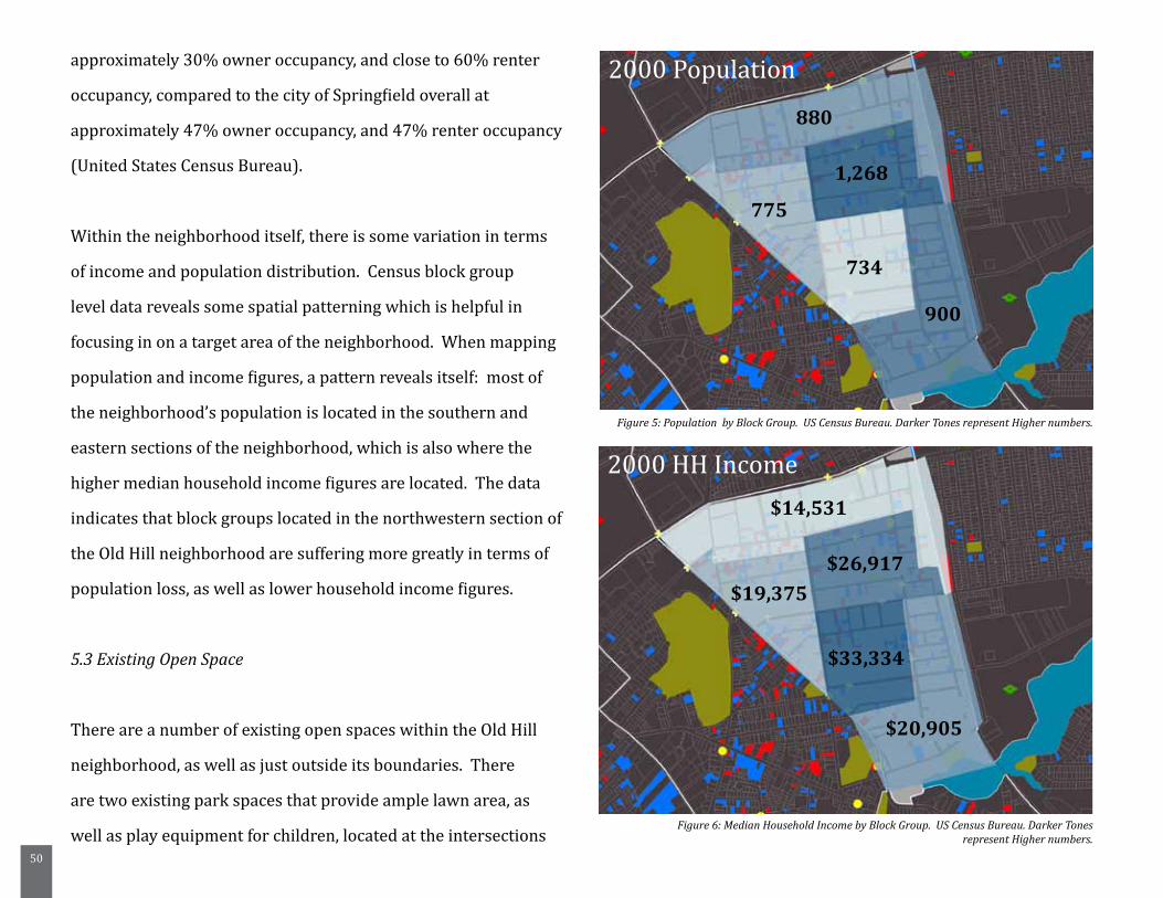
50
approximately 30% owner occupancy, and close to 60% renter
occupancy, compared to the city of Springfield overall at
approximately 47% owner occupancy, and 47% renter occupancy
(United States Census Bureau).
Within the neighborhood itself, there is some variation in terms
of income and population distribution. Census block group
level data reveals some spatial patterning which is helpful in
focusing in on a target area of the neighborhood. When mapping
population and income figures, a pattern reveals itself: most of
the neighborhood’s population is located in the southern and
eastern sections of the neighborhood, which is also where the
higher median household income figures are located. The data
indicates that block groups located in the northwestern section of
the Old Hill neighborhood are suffering more greatly in terms of
population loss, as well as lower household income figures.
5.3 Existing Open Space
There are a number of existing open spaces within the Old Hill
neighborhood, as well as just outside its boundaries. There
are two existing park spaces that provide ample lawn area, as
well as play equipment for children, located at the intersections
Figure 5: Population by Block Group. US Census Bureau. Darker Tones represent Higher numbers.
Figure 6: Median Household Income by Block Group. US Census Bureau. Darker Tones represent Higher numbers.
880
1,268
775
734
900
2000 Population
2000 HH Income$14,531
$19,375$26,917
$33,334
$20,905
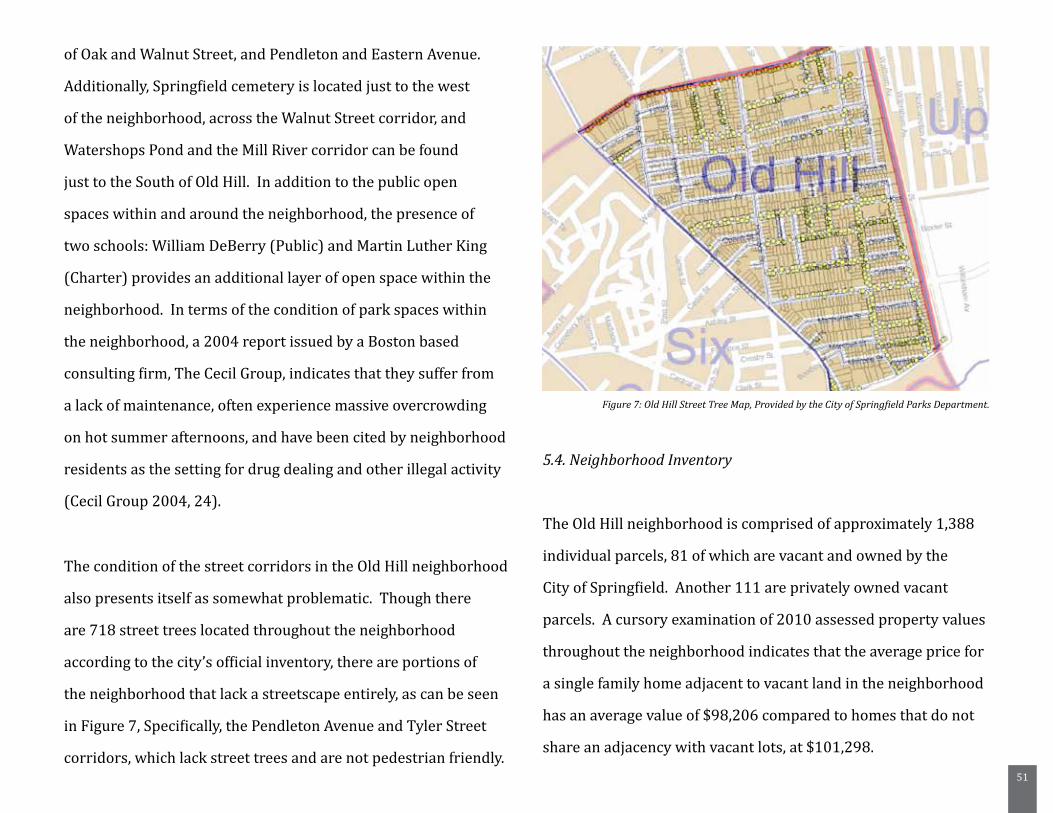
51
of Oak and Walnut Street, and Pendleton and Eastern Avenue.
Additionally, Springfield cemetery is located just to the west
of the neighborhood, across the Walnut Street corridor, and
Watershops Pond and the Mill River corridor can be found
just to the South of Old Hill. In addition to the public open
spaces within and around the neighborhood, the presence of
two schools: William DeBerry (Public) and Martin Luther King
(Charter) provides an additional layer of open space within the
neighborhood. In terms of the condition of park spaces within
the neighborhood, a 2004 report issued by a Boston based
consulting firm, The Cecil Group, indicates that they suffer from
a lack of maintenance, often experience massive overcrowding
on hot summer afternoons, and have been cited by neighborhood
residents as the setting for drug dealing and other illegal activity
(Cecil Group 2004, 24).
The condition of the street corridors in the Old Hill neighborhood
also presents itself as somewhat problematic. Though there
are 718 street trees located throughout the neighborhood
according to the city’s official inventory, there are portions of
the neighborhood that lack a streetscape entirely, as can be seen
in Figure 7, Specifically, the Pendleton Avenue and Tyler Street
corridors, which lack street trees and are not pedestrian friendly.
5.4. Neighborhood Inventory
The Old Hill neighborhood is comprised of approximately 1,388
individual parcels, 81 of which are vacant and owned by the
City of Springfield. Another 111 are privately owned vacant
parcels. A cursory examination of 2010 assessed property values
throughout the neighborhood indicates that the average price for
a single family home adjacent to vacant land in the neighborhood
has an average value of $98,206 compared to homes that do not
share an adjacency with vacant lots, at $101,298.
Figure 7: Old Hill Street Tree Map, Provided by the City of Springfield Parks Department.
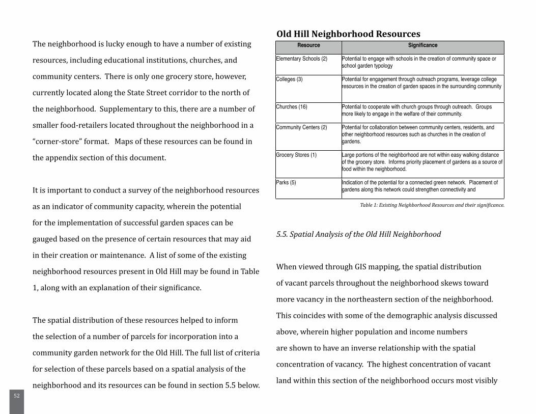
52
The neighborhood is lucky enough to have a number of existing
resources, including educational institutions, churches, and
community centers. There is only one grocery store, however,
currently located along the State Street corridor to the north of
the neighborhood. Supplementary to this, there are a number of
smaller food-retailers located throughout the neighborhood in a
“corner-store” format. Maps of these resources can be found in
the appendix section of this document.
It is important to conduct a survey of the neighborhood resources
as an indicator of community capacity, wherein the potential
for the implementation of successful garden spaces can be
gauged based on the presence of certain resources that may aid
in their creation or maintenance. A list of some of the existing
neighborhood resources present in Old Hill may be found in Table
1, along with an explanation of their significance.
The spatial distribution of these resources helped to inform
the selection of a number of parcels for incorporation into a
community garden network for the Old Hill. The full list of criteria
for selection of these parcels based on a spatial analysis of the
neighborhood and its resources can be found in section 5.5 below.
5.5. Spatial Analysis of the Old Hill Neighborhood
When viewed through GIS mapping, the spatial distribution
of vacant parcels throughout the neighborhood skews toward
more vacancy in the northeastern section of the neighborhood.
This coincides with some of the demographic analysis discussed
above, wherein higher population and income numbers
are shown to have an inverse relationship with the spatial
concentration of vacancy. The highest concentration of vacant
land within this section of the neighborhood occurs most visibly
Resource Significance
Elementary Schools (2) Potential to engage with schools in the creation of community space or school garden typology
Colleges (3) Potential for engagement through outreach programs, leverage college resources in the creation of garden spaces in the surrounding community
Churches (16) Potential to cooperate with church groups through outreach. Groups more likely to engage in the welfare of their community.
Community Centers (2) Potential for collaboration between community centers, residents, and other neighborhood resources such as churches in the creation of gardens.
Grocery Stores (1) Large portions of the neighborhood are not within easy walking distance of the grocery store. Informs priority placement of gardens as a source of food within the neighborhood.
Parks (5) Indication of the potential for a connected green network. Placement of gardens along this network could strengthen connectivity and
Old Hill Neighborhood Resources
Table 1: Existing Neighborhood Resources and their significance.
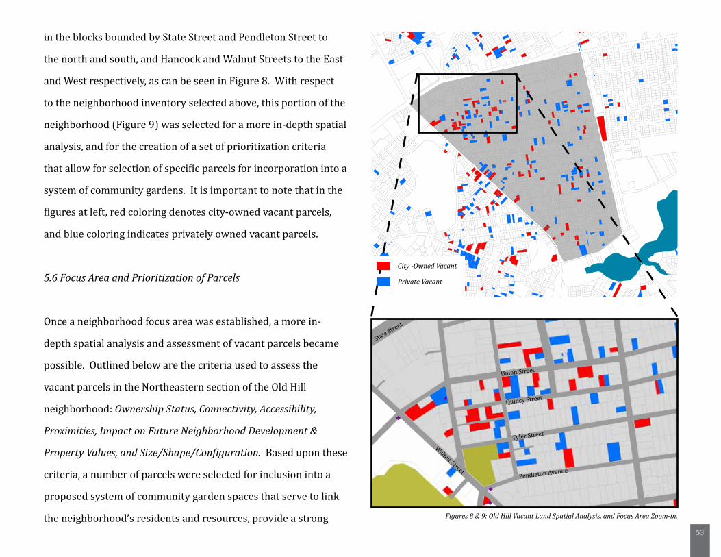
53
in the blocks bounded by State Street and Pendleton Street to
the north and south, and Hancock and Walnut Streets to the East
and West respectively, as can be seen in Figure 8. With respect
to the neighborhood inventory selected above, this portion of the
neighborhood (Figure 9) was selected for a more in-depth spatial
analysis, and for the creation of a set of prioritization criteria
that allow for selection of specific parcels for incorporation into a
system of community gardens. It is important to note that in the
figures at left, red coloring denotes city-owned vacant parcels,
and blue coloring indicates privately owned vacant parcels.
5.6 Focus Area and Prioritization of Parcels
Once a neighborhood focus area was established, a more in-
depth spatial analysis and assessment of vacant parcels became
possible. Outlined below are the criteria used to assess the
vacant parcels in the Northeastern section of the Old Hill
neighborhood: Ownership Status, Connectivity, Accessibility,
Proximities, Impact on Future Neighborhood Development &
Property Values, and Size/Shape/Configuration. Based upon these
criteria, a number of parcels were selected for inclusion into a
proposed system of community garden spaces that serve to link
the neighborhood’s residents and resources, provide a strong Figures 8 & 9: Old Hill Vacant Land Spatial Analysis, and Focus Area Zoom-in.
City -Owned Vacant
Private Vacant
Union Street
Quincy Street
Tyler Street
Pendleton Avenue
Walnut Street
State Street
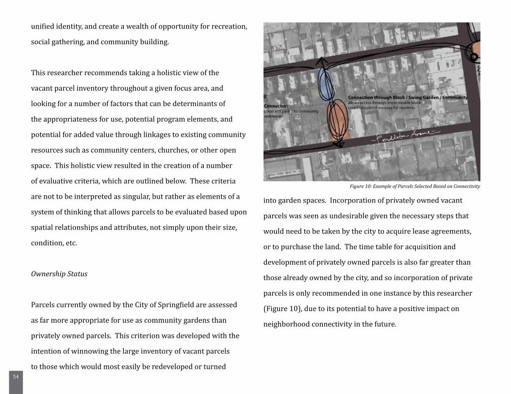
54
unified identity, and create a wealth of opportunity for recreation,
social gathering, and community building.
This researcher recommends taking a holistic view of the
vacant parcel inventory throughout a given focus area, and
looking for a number of factors that can be determinants of
the appropriateness for use, potential program elements, and
potential for added value through linkages to existing community
resources such as community centers, churches, or other open
space. This holistic view resulted in the creation of a number
of evaluative criteria, which are outlined below. These criteria
are not to be interpreted as singular, but rather as elements of a
system of thinking that allows parcels to be evaluated based upon
spatial relationships and attributes, not simply upon their size,
condition, etc.
Ownership Status
Parcels currently owned by the City of Springfield are assessed
as far more appropriate for use as community gardens than
privately owned parcels. This criterion was developed with the
intention of winnowing the large inventory of vacant parcels
to those which would most easily be redeveloped or turned
into garden spaces. Incorporation of privately owned vacant
parcels was seen as undesirable given the necessary steps that
would need to be taken by the city to acquire lease agreements,
or to purchase the land. The time table for acquisition and
development of privately owned parcels is also far greater than
those already owned by the city, and so incorporation of private
parcels is only recommended in one instance by this researcher
(Figure 10), due to its potential to have a positive impact on
neighborhood connectivity in the future.
Figure 10: Example of Parcels Selected Based on Connectivity
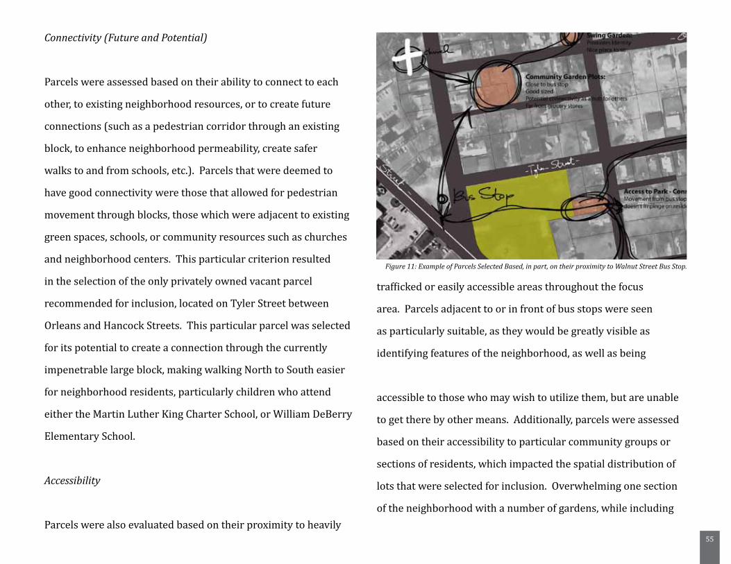
55
Connectivity (Future and Potential)
Parcels were assessed based on their ability to connect to each
other, to existing neighborhood resources, or to create future
connections (such as a pedestrian corridor through an existing
block, to enhance neighborhood permeability, create safer
walks to and from schools, etc.). Parcels that were deemed to
have good connectivity were those that allowed for pedestrian
movement through blocks, those which were adjacent to existing
green spaces, schools, or community resources such as churches
and neighborhood centers. This particular criterion resulted
in the selection of the only privately owned vacant parcel
recommended for inclusion, located on Tyler Street between
Orleans and Hancock Streets. This particular parcel was selected
for its potential to create a connection through the currently
impenetrable large block, making walking North to South easier
for neighborhood residents, particularly children who attend
either the Martin Luther King Charter School, or William DeBerry
Elementary School.
Accessibility
Parcels were also evaluated based on their proximity to heavily
trafficked or easily accessible areas throughout the focus
area. Parcels adjacent to or in front of bus stops were seen
as particularly suitable, as they would be greatly visible as
identifying features of the neighborhood, as well as being
accessible to those who may wish to utilize them, but are unable
to get there by other means. Additionally, parcels were assessed
based on their accessibility to particular community groups or
sections of residents, which impacted the spatial distribution of
lots that were selected for inclusion. Overwhelming one section
of the neighborhood with a number of gardens, while including
Figure 11: Example of Parcels Selected Based, in part, on their proximity to Walnut Street Bus Stop.
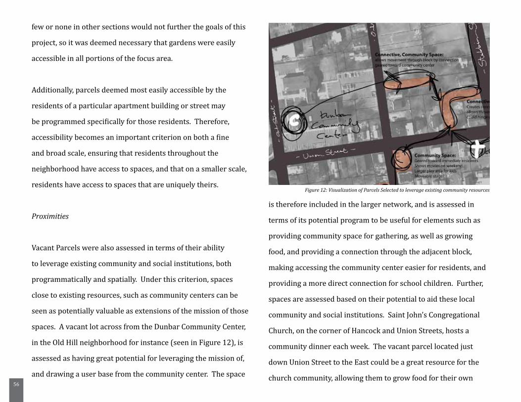
56
few or none in other sections would not further the goals of this
project, so it was deemed necessary that gardens were easily
accessible in all portions of the focus area.
Additionally, parcels deemed most easily accessible by the
residents of a particular apartment building or street may
be programmed specifically for those residents. Therefore,
accessibility becomes an important criterion on both a fine
and broad scale, ensuring that residents throughout the
neighborhood have access to spaces, and that on a smaller scale,
residents have access to spaces that are uniquely theirs.
Proximities
Vacant Parcels were also assessed in terms of their ability
to leverage existing community and social institutions, both
programmatically and spatially. Under this criterion, spaces
close to existing resources, such as community centers can be
seen as potentially valuable as extensions of the mission of those
spaces. A vacant lot across from the Dunbar Community Center,
in the Old Hill neighborhood for instance (seen in Figure 12), is
assessed as having great potential for leveraging the mission of,
and drawing a user base from the community center. The space
is therefore included in the larger network, and is assessed in
terms of its potential program to be useful for elements such as
providing community space for gathering, as well as growing
food, and providing a connection through the adjacent block,
making accessing the community center easier for residents, and
providing a more direct connection for school children. Further,
spaces are assessed based on their potential to aid these local
community and social institutions. Saint John’s Congregational
Church, on the corner of Hancock and Union Streets, hosts a
community dinner each week. The vacant parcel located just
down Union Street to the East could be a great resource for the
church community, allowing them to grow food for their own
Figure 12: Visualization of Parcels Selected to leverage existing community resources
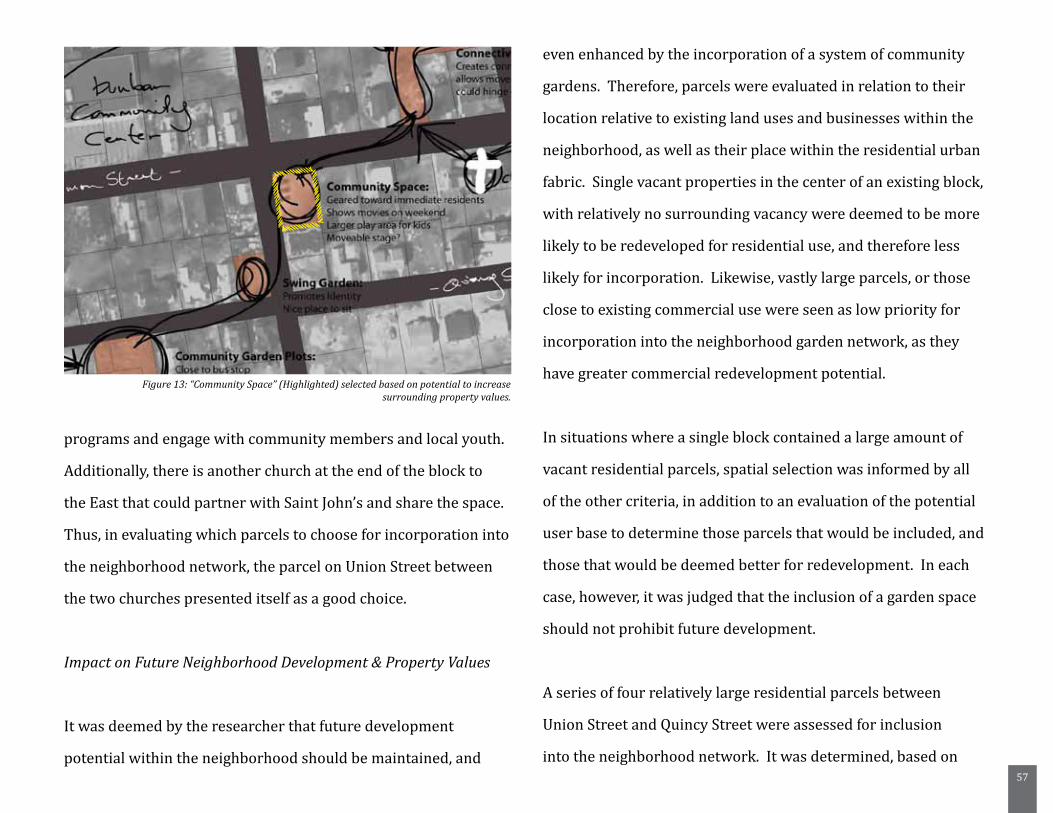
57
programs and engage with community members and local youth.
Additionally, there is another church at the end of the block to
the East that could partner with Saint John’s and share the space.
Thus, in evaluating which parcels to choose for incorporation into
the neighborhood network, the parcel on Union Street between
the two churches presented itself as a good choice.
Impact on Future Neighborhood Development & Property Values
It was deemed by the researcher that future development
potential within the neighborhood should be maintained, and
even enhanced by the incorporation of a system of community
gardens. Therefore, parcels were evaluated in relation to their
location relative to existing land uses and businesses within the
neighborhood, as well as their place within the residential urban
fabric. Single vacant properties in the center of an existing block,
with relatively no surrounding vacancy were deemed to be more
likely to be redeveloped for residential use, and therefore less
likely for incorporation. Likewise, vastly large parcels, or those
close to existing commercial use were seen as low priority for
incorporation into the neighborhood garden network, as they
have greater commercial redevelopment potential.
In situations where a single block contained a large amount of
vacant residential parcels, spatial selection was informed by all
of the other criteria, in addition to an evaluation of the potential
user base to determine those parcels that would be included, and
those that would be deemed better for redevelopment. In each
case, however, it was judged that the inclusion of a garden space
should not prohibit future development.
A series of four relatively large residential parcels between
Union Street and Quincy Street were assessed for inclusion
into the neighborhood network. It was determined, based on
Figure 13: “Community Space” (Highlighted) selected based on potential to increase surrounding property values.
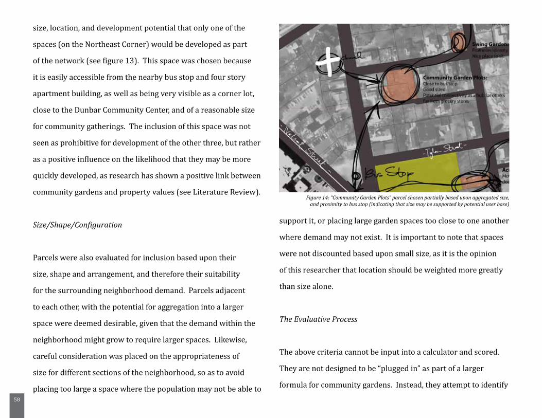
58
size, location, and development potential that only one of the
spaces (on the Northeast Corner) would be developed as part
of the network (see figure 13). This space was chosen because
it is easily accessible from the nearby bus stop and four story
apartment building, as well as being very visible as a corner lot,
close to the Dunbar Community Center, and of a reasonable size
for community gatherings. The inclusion of this space was not
seen as prohibitive for development of the other three, but rather
as a positive influence on the likelihood that they may be more
quickly developed, as research has shown a positive link between
community gardens and property values (see Literature Review).
Size/Shape/Configuration
Parcels were also evaluated for inclusion based upon their
size, shape and arrangement, and therefore their suitability
for the surrounding neighborhood demand. Parcels adjacent
to each other, with the potential for aggregation into a larger
space were deemed desirable, given that the demand within the
neighborhood might grow to require larger spaces. Likewise,
careful consideration was placed on the appropriateness of
size for different sections of the neighborhood, so as to avoid
placing too large a space where the population may not be able to
support it, or placing large garden spaces too close to one another
where demand may not exist. It is important to note that spaces
were not discounted based upon small size, as it is the opinion
of this researcher that location should be weighted more greatly
than size alone.
The Evaluative Process
The above criteria cannot be input into a calculator and scored.
They are not designed to be “plugged in” as part of a larger
formula for community gardens. Instead, they attempt to identify
Figure 14: “Community Garden Plots” parcel chosen partially based upon aggregated size, and proximity to bus stop (indicating that size may be supported by potential user base)
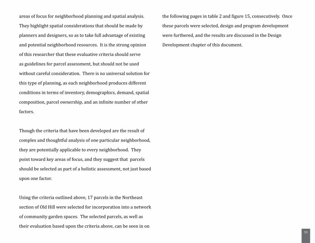
59
areas of focus for neighborhood planning and spatial analysis.
They highlight spatial considerations that should be made by
planners and designers, so as to take full advantage of existing
and potential neighborhood resources. It is the strong opinion
of this researcher that these evaluative criteria should serve
as guidelines for parcel assessment, but should not be used
without careful consideration. There is no universal solution for
this type of planning, as each neighborhood produces different
conditions in terms of inventory, demographics, demand, spatial
composition, parcel ownership, and an infinite number of other
factors.
Though the criteria that have been developed are the result of
complex and thoughtful analysis of one particular neighborhood,
they are potentially applicable to every neighborhood. They
point toward key areas of focus, and they suggest that parcels
should be selected as part of a holistic assessment, not just based
upon one factor.
Using the criteria outlined above, 17 parcels in the Northeast
section of Old Hill were selected for incorporation into a network
of community garden spaces. The selected parcels, as well as
their evaluation based upon the criteria above, can be seen in on
the following pages in table 2 and figure 15, consecutively. Once
these parcels were selected, design and program development
were furthered, and the results are discussed in the Design
Development chapter of this document.
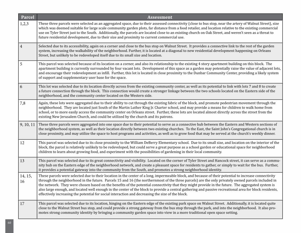
60
Parcel Assessment1,2,3 These three parcels were selected as an aggregated space, due to their assessed connectivity (close to bus stop, near the artery of Walnut Street), size
which was deemed suitable for large scale community garden plots, far distance from a food retailer, and location relative to the existing commercial use on Tyler Street just to the South. Additionally, the parcels are located close to an existing church on Oak Street, and weren’t seen as a threat to future residential development, due to their size and proximity to current commercial use.
4 Selected due to its accessibility, again on a corner and close to the bus stop on Walnut Street. It provides a connective link to the rest of the garden system, increasing the walkability of the neighborhood. Further, it is located at a diagonal to new residential development happening on Orleans Street, but unlikely to be redeveloped itself due to its small size and location.
5 This parcel was selected because of its location on a corner, and also its relationship to the existing 4 story apartment building on this block. The apartment building is currently surrounded by four vacant lots. Development of this space as a garden may potentially raise the value of adjacent lots, and encourage their redevelopment as infill. Further, this lot is located in close proximity to the Dunbar Community Center, providing a likely system of support and supplementary user base for the space.
6 This lot was selected due to its location directly across from the existing community center, as well as its potential to link with lots 7 and 8 to create a future connection through the block. This connection would create a stronger linkage between the two schools located on the Eastern side of the neighborhood, and the community center located on the Western side.
7,8 Again, these lots were aggregated due to their ability to cut through the existing fabric of the block, and promote pedestrian movement through the neighborhood. They are located just South of the Martin Luther King Jr. Charter school, and may provide a means for children to walk home from school, or to more easily access the community center on Orleans street. Further, these lots are located almost directly across the street from the existing New Jerusalem Church, and could be utilized by the church and its patrons.
9, 10, 11 These three parcels were aggregated into one space due to their potential to serve as a connective hub between the Eastern and Western sections of the neighborhood system, as well as their location directly between two existing churches. To the East, the Saint John’s Congregational church is in close proximity, and may utilize the space to host programs and activities, as well as to grow food that may be served at the church’s weekly dinner.
12 This parcel was selected due to its close proximity to the William DeBerry Elementary school. Due to its small size, and location on the interior of the block, the parcel is relatively unlikely to be redeveloped, but could serve a great purpose as a school garden or educational space for neighborhood children to learn about growing food, and experiment with the possibilities of gardening in their local community.
13 This parcel was selected due to its great connectivity and visibility. Located on the corner of Tyler Street and Hancock street, it can serve as a commu-nity hub on the Eastern edge of the neighborhood network, and create a pleasant space for residents to gather, or simply to wait for the bus. Further, it provides a potential gateway into the community from the South, and promotes a strong neighborhood identity.
14, 15, 16
These parcels were selected due to their location in the center of a long, impermeable block, and because of their potential to increase connectivity through the neighborhood in the future. Parcels 15 and 16 (the northernmost of the three parcels) are the only privately owned parcels included in the network. They were chosen based on the benefits of the potential connectivity that they might provide in the future. The aggregated system is also large enough, and located well enough in the center of the block to provide a central gathering and passive recreational area for block residents, effectively increasing the potential for social interaction and decreasing the size of the block.
17 This parcel was selected due to its location, hinging on the Eastern edge of the existing park space on Walnut Street. Additionally, it is located quite close to the Walnut Street bus stop, and could provide a strong gateway from the bus stop through the park, and into the neighborhood. It also pro-motes strong community identity by bringing a community garden space into view in a more traditional open space setting.
61
State Street
Union Street
Quincy Street
Pendleton Avenue
Han
cock
Str
eet
Oak
Str
eet
Walnut Street
Tyler Street
62
6. Case Study Research
Case studies were conducted as a method to address a number of
the current challenges to community gardening in Springfield, by
highlighting a few ways in which successful programs are being
conducted. Individual case studies were selected based on their
relevance to specific issues being faced by the city of Springfield:
- Lack of a clear municipal standpoint on community gardening,
and support of community gardening efforts
- Unclear or restrictive zoning codes
- Lack of a comprehensive inventory of vacant parcels, and a
strategy to alleviate the problems caused by these properties
- Perception of gardens as messy, unkempt spaces
In an attempt to provide a relevant point of view pertaining to
each of the above issues, three specific cases, on three different
scales were selected. To address the issues of municipal
cooperation and support, as well as addressing restrictive zoning
codes, the City of Seattle was selected as a case study. Seattle is
a model of unique municipal support for community gardening
efforts, through its incorporation of a strategy for community
gardens in the City’s comprehensive plan, as well as through the
vibrant and successful P-Patch program.
To provide insight into strategies being used to alleviate the
pressure on neighborhoods being caused by an abundance of
vacant parcels, as well as to investigate how community capacity
can be built through these types of projects, the city of Flint,
Michigan will be studied - particularly in light of the Genesee
County Land Bank. The land bank is currently providing an
incredibly valuable service to residents and the city alike through
its various programs, including “Adopt-a-lot”, “Clean and Green”,
and programs designed to facilitate the purchase of vacant
parcels by community residents, to decrease blight and get
properties back on the tax rolls.
Finally, as a study in site design and community involvement
in the creation of community gardens, the former Lola Bryant
Community Garden (now known as the Bedford Stuyvesant
Community Garden) will be studied. This garden is successful for
a variety of reasons, most notably its incorporation of a variety of

63
unusual materials and design elements, and the way in which it
addresses the needs and desires of its neighborhood. it creates.
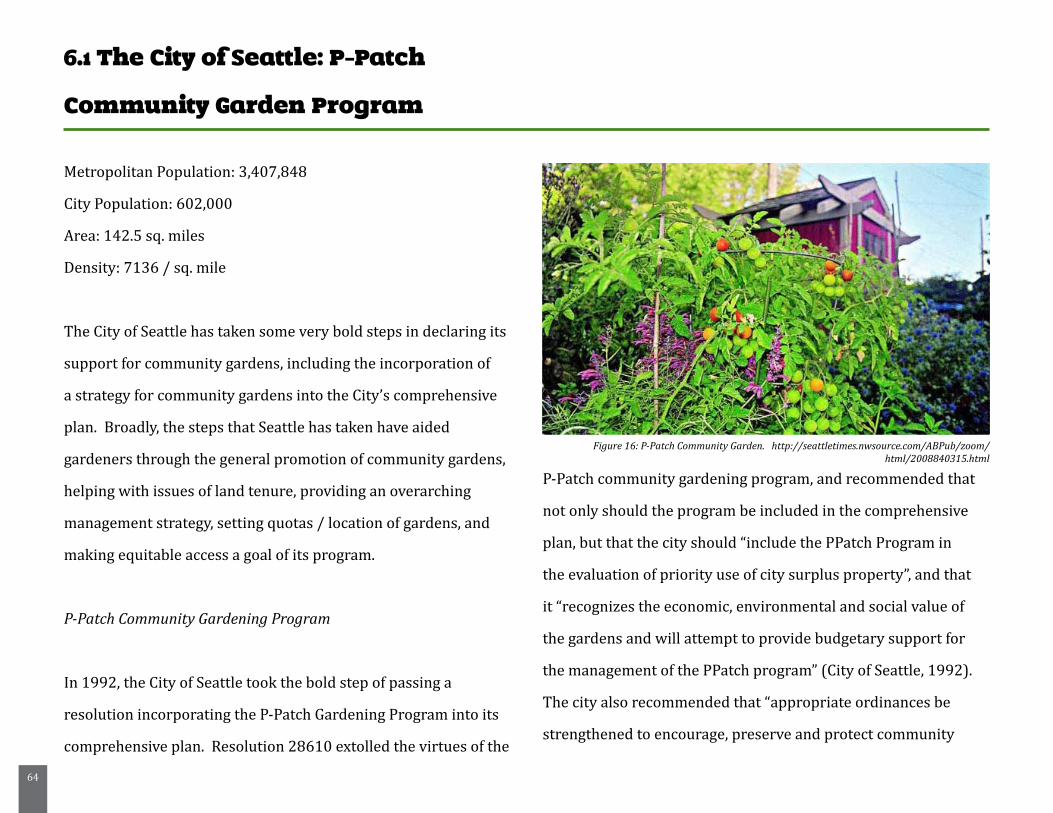
64
6.1 The City of Seattle: P-Patch
Community Garden Program
Metropolitan Population: 3,407,848
City Population: 602,000
Area: 142.5 sq. miles
Density: 7136 / sq. mile
The City of Seattle has taken some very bold steps in declaring its
support for community gardens, including the incorporation of
a strategy for community gardens into the City’s comprehensive
plan. Broadly, the steps that Seattle has taken have aided
gardeners through the general promotion of community gardens,
helping with issues of land tenure, providing an overarching
management strategy, setting quotas / location of gardens, and
making equitable access a goal of its program.
P-Patch Community Gardening Program
In 1992, the City of Seattle took the bold step of passing a
resolution incorporating the P-Patch Gardening Program into its
comprehensive plan. Resolution 28610 extolled the virtues of the
P-Patch community gardening program, and recommended that
not only should the program be included in the comprehensive
plan, but that the city should “include the P Patch Program in
the evaluation of priority use of city surplus property”, and that
it “recognizes the economic, environmental and social value of
the gardens and will attempt to provide budgetary support for
the management of the P Patch program” (City of Seattle, 1992).
The city also recommended that “appropriate ordinances be
strengthened to encourage, preserve and protect community
Figure 16: P-Patch Community Garden. http://seattletimes.nwsource.com/ABPub/zoom/html/2008840315.html

65
gardening particularly in medium and high density residential
areas” (City of Seattle, 1992). Further, and quite remarkably, the
resolution set a goal for the incorporation of community gardens
throughout the city, aiming to create at least one garden per 2,500
households (City of Seattle, 1992).
The program is currently run out of the City’s Department
of Neighborhoods, and is responsible for managing 71
P-Patches, with at least an additional dozen in the design,
planning, or development stages (City of Seattle Department of
Neighborhoods, n.d.). The program has 8 full time employees,
with 5.5 full time employees that provide direct community
garden coordination services. These services include assigning
plots to interested gardeners, helping to negotiate land access
for new gardens, and assisting with fundraising, soil testing, and
volunteer training sessions (Kaethler 2006, 22). The P-Patch
program operates a number of community based program
areas, including community gardening, market gardening, youth
gardening, and community food security in the city (Seattle
Department of Neighborhoods, 2010). Gardens are allowed
in all zoning districts, as a recreational use of open space,
with no permit required (Kaethler 2006, 22). P-Patch gardens
accommodate over 4,000 gardeners in the city of Seattle on
approximately 2,000 plots, using exclusively organic gardening
techniques. Each year, P-Patch gardeners donate anywhere from
7-10 tons of fresh produce to their local food bank (City of Seattle
Department of Neighborhoods, n.d.).
The P-Patch program also benefits from its close relationship
with the non-profit P-Patch Trust, an organization that works
to acquire, build, preserve and protect community gardens in
Seattle’s neighborhoods (P-Patch Trust, 2010). The P-Patch trust
serves as a system of support for the P-Patch Program, advocating
on behalf of gardeners throughout the area, and helping to
create new gardens and provide support for existing gardens.
Additionally, the P-Patch Trust works to provide small grants for
starting gardens, pay plot-fees for low income residents, and to
provide tools for gardeners to use(P-Patch Trust, 2010).
66
Additionally, the city’s Neighborhood Matching Fund provides a
great resource for projects such as community garden initiatives.
The matching fund was created in 1988 in order to “provide
neighborhood groups with city resources for community-driven
projects that enhance and strengthen their own neighborhoods.
All projects are initiated, planned and implemented by
community members in partnership with the city” (Seattle
Department of Neighborhoods, 2010). Each award given by the
city is matched through the “community match” process, which
means that the community matches the funds provided by the
city through volunteer labor, materials, professional services, or
cash. This network of collaboration and cooperation between
community members, municipal government, and non-profit
organizations has allowed many community garden projects to be
successfully implemented in the city of Seattle.
Lessons Learned:
Lesson 1: Partnerships are key to success:
Seattle’s P-Patch program is incredibly successful at least in part
due to the strength of the partnerships that it has been able to
establish. A support network of other non-profit entities, as well
as cooperation with other community initiatives, tie the program
to the community in a very tangible way, while also extending
the reach of the program’s influence. Through support from
the P-Patch trust, which has a mission of focusing on garden
acquisition and development, as well as program support and
advocacy, the P-Patch program is able to establish more gardens,
and to provide more services than it could simply through its
own means. Further, the P-Patch program is also in cooperation
with the Solid Ground Lettuce Link program, a partnership
that encourages and supports Seattle gardeners in growing
extra produce in their patch, to support local food banks, meals
programs, and homeless shelters. According to the city of Seattle,
this partnership results in massive donations (more than 25,000
pounds of fruits and vegetables each year) to local food providers,
helping hundreds of people who may not otherwise have access
to fresh, healthy produce (Seattle Department of Neighborhoods,
2010). The City of Springfield should pursue meaningful
partnerships with the organizations already attempting to
establish community gardens in the city, and attempt to support
their efforts. Further, the newly created Springfield Design Center
(in partnership with the University of Massachusetts) could be
an excellent way to foster a cooperative spirit in the interest of
67
community gardens throughout the city, engaging community
members, students, and city government in action toward a
common goal.
Lesson 2: Importance of planning for gardens:
Incorporation of Community Gardens into a comprehensive plan
makes a powerful statement about the attitude of a city toward
the health of its residents. With the overwhelming evidence
(much of which is cited in the Literature Review Chapter of this
document) that community gardens are beneficial to the health
of residents and neighborhoods, as well as to crime reduction
efforts, the City of Springfield could take a very powerful, tangible
step by acknowledging the value of gardens in its comprehensive
plan, or open space plan, preferably both. Further, this researcher
recommends that the city should re-examine its zoning code to
ensure that community gardens are an approved use in every
zone, as has been done in the City of Seattle. At the very least, a
definition and acknowledgement of community gardens needs to
be included in the zoning code, which currently includes no such
reference.
Lesson 3: The power of cooperation and general promotion of
gardens in the creation of a “garden culture”:
Seattle’s P-Patch program is a key example of how important the
general promotion of gardens (in this case through incorporation
into the City’s Comprehensive Plan) is in the establishment of a
“garden culture” in the urban environment. As established in the
Literature Review chapter of this document, neighborhoods with
community gardens are far more likely to be addressing other
neighborhood issues, such as crime, and taking an interest in one
another, building social capital through the networks that are
established by gardening. The creation of this type of informal
social networking could greatly benefit the City of Springfield’s
inner city neighborhoods, where neighborhood conditions and
the lack of community cohesion lead to a relatively isolated
population.
As will be seen in the Flint, Michigan case study to follow, the
power of a “garden culture” should not be underestimated when
it comes to the potential for social growth, and real neighborhood
revitalization.
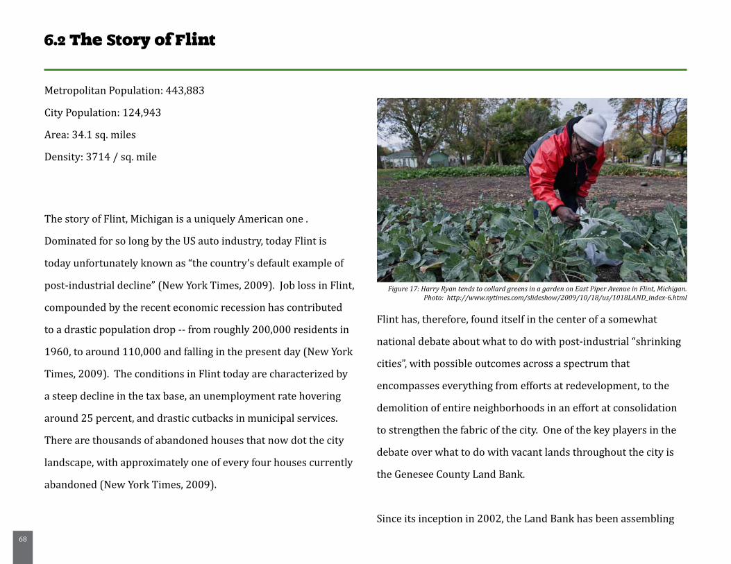
68
6.2 The Story of Flint
Metropolitan Population: 443,883
City Population: 124,943
Area: 34.1 sq. miles
Density: 3714 / sq. mile
The story of Flint, Michigan is a uniquely American one .
Dominated for so long by the US auto industry, today Flint is
today unfortunately known as “the country’s default example of
post-industrial decline” (New York Times, 2009). Job loss in Flint,
compounded by the recent economic recession has contributed
to a drastic population drop -- from roughly 200,000 residents in
1960, to around 110,000 and falling in the present day (New York
Times, 2009). The conditions in Flint today are characterized by
a steep decline in the tax base, an unemployment rate hovering
around 25 percent, and drastic cutbacks in municipal services.
There are thousands of abandoned houses that now dot the city
landscape, with approximately one of every four houses currently
abandoned (New York Times, 2009).
Flint has, therefore, found itself in the center of a somewhat
national debate about what to do with post-industrial “shrinking
cities”, with possible outcomes across a spectrum that
encompasses everything from efforts at redevelopment, to the
demolition of entire neighborhoods in an effort at consolidation
to strengthen the fabric of the city. One of the key players in the
debate over what to do with vacant lands throughout the city is
the Genesee County Land Bank.
Since its inception in 2002, the Land Bank has been assembling
Figure 17: Harry Ryan tends to collard greens in a garden on East Piper Avenue in Flint, Michigan.Photo: http://www.nytimes.com/slideshow/2009/10/18/us/1018LAND_index-6.html
69
lands to be transferred to adjacent homeowners, developing
green spaces throughout neighborhoods, and assessing land for
potential residential and commercial redevelopment. Overall, the
goal of the Land Bank is to “restore the integrity of the community
by removing dilapidated structures and redeveloping abandoned
properties” (Genesee County Land Bank, 2010). The land bank
acquires properties through the tax foreclosure process, and today
is responsible for encouraging the reuse of over 4,000 former
residential, commercial, and industrial properties (Genesee County
Land Bank, 2010). It does this through strategic partnerships with
public, private and non-profit entities, as well as with the monies
that it makes from the tax foreclosure process, sales and rental
programs and other sources such as grants, loans, and bonds.
Currently, the Land Bank administers ten programs: Planning and
Outreach, Brownfield Redevelopment, Development, Adopt-a-lot,
Clean and Green, Demolition, Housing Renovation, Sales, Side Lot
Transfer, and Foreclosure Prevention. For the purposes of this
case study, three of these programs will be highlighted for their
ability to give individuals, businesses, community groups and other
organizations the opportunity to maintain and control vacant land
throughout their neighborhood for a variety of purposes. These
three programs are Side Lot Transfer, Clean and Green, and
Adopt-A-Lot.
Under the Side Lot Transfer program, homeowners in the city
of Flint with vacant Land Bank owned properties adjacent to
their home are eligible to purchase that property as a Side Yard
for their residence. The cost for this program is a $25 fee, plus
the foreclosure year’s taxes (if the property was foreclosed in
2003 or prior), an administration fee of $25, and a $14 filing
fee (Genesee County Land Bank, 2010). This program helps
to return vacant lots to productive use, puts them back on the
tax rolls, and reduces costs to the city for their maintenance.
Further, the land bank provides resources to guide purchasers
in the development of their new lots as a side yard or garden.
The Clean and Green Program is another innovative idea,
which “supports neighborhood efforts to convert vacant Land
Bank property into gardens and green space” (Genesee County
Land Bank, 2010). Through a series of local partnerships,
70
the Land Bank provides resources for neighborhood residents
and community groups to engage in the greening of their
communities through maintenance and the creation of green
spaces and gardens. Currently, the Clean and Green program
has a competitive application process, during which groups
or organizations apply for the opportunity to participate. If
accepted, the participants receive project funds of no more
than $4,500 per group, with which they are required to take
care of at least 25 Land Bank owned vacant properties in their
area(maintenance and upkeep, etc.) as well as to develop at least
two gardening projects. According to the Land Bank website,
“Groups are strongly encouraged to include vegetable gardens
and to involve area youth as part of their garden projects”
(Genesee County Land Bank, 2010). Besides vegetable gardens,
gardening projects may include flower gardens, decorative
fencing, tree planting, low maintenance landscaping, and signage.
Finally, the Adopt-A-Lot program gives residents, businesses and
community groups the opportunity to maintain and control Land
Bank owned vacant properties in their neighborhood “without
the burden of taxes or other financial obligations that come with
ownership” (Genesee County Land Bank, 2010). Though this
type of program has existed informally in Flint since it started to
experience the loss of population and housing, it is formalized
through the land bank as a method of improving neighborhood
appearance, increasing property values, and lowering the
incidence of neighborhood crime. It is free for anyone to adopt
a lot through the application process, and the program also
provides resources such as technical assistance with gardening
techniques, property maintenance, site design, and selection
of planting materials. Additionally, adopters gain special
consideration for purchase of the specific lot, if desired (Genesee
County Land Bank, 2010).
These types of initiatives are critically important, as they increase
the accessibility to and visibility of urban gardening within Flint
and the surrounding area. By allowing residents ease of access
to tenure on some of the vacant lands throughout Flint, and by
increasing the visibility of these types of ventures, the Genesee
County Land Bank is helping to create a garden culture in the
city. As a result, community gardens are sprouting up throughout
Flint, and there is excitement brewing about their potential to
contribute to neighborhood revitalization. One particular story,
told in a 2009 New York Times article, details the story of a man
named Harry Ryan, a lifetime resident of Flint who found himself
unemployed following mass layoffs of auto workers in the area.
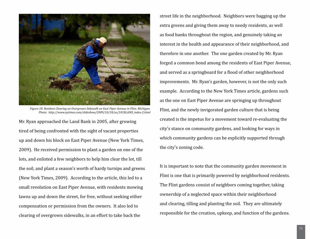
71
Mr. Ryan approached the Land Bank in 2005, after growing
tired of being confronted with the sight of vacant properties
up and down his block on East Piper Avenue (New York Times,
2009). He received permission to plant a garden on one of the
lots, and enlisted a few neighbors to help him clear the lot, till
the soil, and plant a season’s worth of hardy turnips and greens
(New York Times, 2009). According to the article, this led to a
small revolution on East Piper Avenue, with residents mowing
lawns up and down the street, for free, without seeking either
compensation or permission from the owners. It also led to
clearing of overgrown sidewalks, in an effort to take back the
street life in the neighborhood. Neighbors were bagging up the
extra greens and giving them away to needy residents, as well
as food banks throughout the region, and genuinely taking an
interest in the health and appearance of their neighborhood, and
therefore in one another. The one garden created by Mr. Ryan
forged a common bond among the residents of East Piper Avenue,
and served as a springboard for a flood of other neighborhood
improvements. Mr. Ryan’s garden, however, is not the only such
example. According to the New York Times article, gardens such
as the one on East Piper Avenue are springing up throughout
Flint, and the newly invigorated garden culture that is being
created is the impetus for a movement toward re-evaluating the
city’s stance on community gardens, and looking for ways in
which community gardens can be explicitly supported through
the city’s zoning code.
It is important to note that the community garden movement in
Flint is one that is primarily powered by neighborhood residents.
The Flint gardens consist of neighbors coming together, taking
ownership of a neglected space within their neighborhood
and clearing, tilling and planting the soil. They are ultimately
responsible for the creation, upkeep, and function of the gardens.
Figure 18: Resident Clearing an Overgrown Sidewalk on East Piper Avenue in Flint, Michigan.Photo: http://www.nytimes.com/slideshow/2009/10/18/us/1018LAND_index-2.html
72
Lessons Learned:
Lesson 1: Land tenure issues can be solved creatively:
As can be seen through the work being done at the Genesee
County Land Bank, there are creative, innovative ways to grant
community members tenure on land, and thereby a stake in
the future of their own neighborhood. Through programs like
Side Lot Transfer, Adopt-A-Lot, and Clean and Green, the land
bank is promoting the revitalization of urban communities from
within, and making it easy for people to access and improve
the land. With these types of tools, communities can begin to
envision their role in regaining control over their neighborhoods,
which is a very powerful thing. The City of Springfield should
investigate the potential for granting access to community
members to garden on vacant lots in their neighborhood, at least
on a contractual, temporary basis. Rather than having these
lots remain fenced off, inaccessible blighting influences on their
neighborhoods, they could become a positive force pushing
toward revitalization.

73
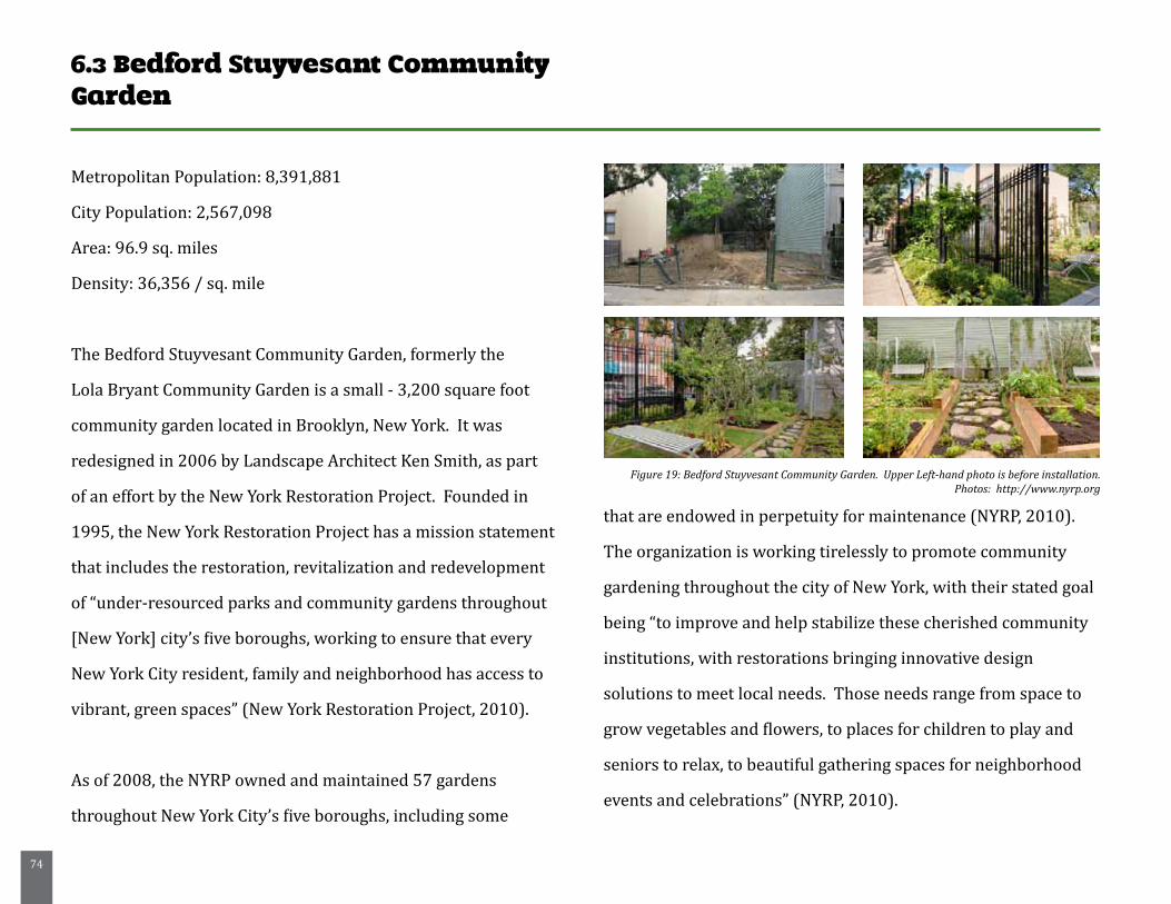
74
6.3 Bedford Stuyvesant Community Garden
Metropolitan Population: 8,391,881
City Population: 2,567,098
Area: 96.9 sq. miles
Density: 36,356 / sq. mile
The Bedford Stuyvesant Community Garden, formerly the
Lola Bryant Community Garden is a small - 3,200 square foot
community garden located in Brooklyn, New York. It was
redesigned in 2006 by Landscape Architect Ken Smith, as part
of an effort by the New York Restoration Project. Founded in
1995, the New York Restoration Project has a mission statement
that includes the restoration, revitalization and redevelopment
of “under-resourced parks and community gardens throughout
[New York] city’s five boroughs, working to ensure that every
New York City resident, family and neighborhood has access to
vibrant, green spaces” (New York Restoration Project, 2010).
As of 2008, the NYRP owned and maintained 57 gardens
throughout New York City’s five boroughs, including some
that are endowed in perpetuity for maintenance (NYRP, 2010).
The organization is working tirelessly to promote community
gardening throughout the city of New York, with their stated goal
being “to improve and help stabilize these cherished community
institutions, with restorations bringing innovative design
solutions to meet local needs. Those needs range from space to
grow vegetables and flowers, to places for children to play and
seniors to relax, to beautiful gathering spaces for neighborhood
events and celebrations” (NYRP, 2010).
Figure 19: Bedford Stuyvesant Community Garden. Upper Left-hand photo is before installation.Photos: http://www.nyrp.org
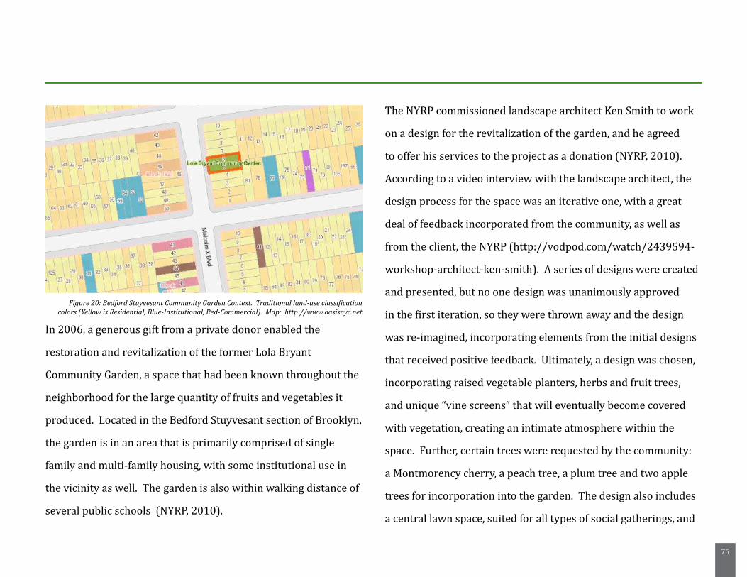
75
In 2006, a generous gift from a private donor enabled the
restoration and revitalization of the former Lola Bryant
Community Garden, a space that had been known throughout the
neighborhood for the large quantity of fruits and vegetables it
produced. Located in the Bedford Stuyvesant section of Brooklyn,
the garden is in an area that is primarily comprised of single
family and multi-family housing, with some institutional use in
the vicinity as well. The garden is also within walking distance of
several public schools (NYRP, 2010).
The NYRP commissioned landscape architect Ken Smith to work
on a design for the revitalization of the garden, and he agreed
to offer his services to the project as a donation (NYRP, 2010).
According to a video interview with the landscape architect, the
design process for the space was an iterative one, with a great
deal of feedback incorporated from the community, as well as
from the client, the NYRP (http://vodpod.com/watch/2439594-
workshop-architect-ken-smith). A series of designs were created
and presented, but no one design was unanimously approved
in the first iteration, so they were thrown away and the design
was re-imagined, incorporating elements from the initial designs
that received positive feedback. Ultimately, a design was chosen,
incorporating raised vegetable planters, herbs and fruit trees,
and unique “vine screens” that will eventually become covered
with vegetation, creating an intimate atmosphere within the
space. Further, certain trees were requested by the community:
a Montmorency cherry, a peach tree, a plum tree and two apple
trees for incorporation into the garden. The design also includes
a central lawn space, suited for all types of social gatherings, and
Figure 20: Bedford Stuyvesant Community Garden Context. Traditional land-use classification colors (Yellow is Residential, Blue-Institutional, Red-Commercial). Map: http://www.oasisnyc.net
76
an arbor made from metal scaffold tubings (NYRP, 2010).
A main theme running throughout the space is the incorporation
of traditional amenities using non-traditional materials. Running
throughout the site is a system of paths that are made of recycled
concrete, herbs planted throughout the cracks. Glu-lam - metal
material that is traditionally used in the construction of telephone
and communication infrastructures, is used in trellis structures
that will eventually be home to grape vines overhead (NYRP,
2010).
Additionally, the space incorporates green walls, a boardwalk
area constructed from recycled materials, abundant permeable-
paved areas, and even an extensive rainwater collection system
that takes advantage of the multi-story buildings on both sides of
the garden (NYRP, 2010). Perhaps most importantly, according
to Smith, everything in the garden is edible, apart from the
constructed elements. He also points out that as a landscape
architect, he recognizes that the Bedford Stuyvesant Community
Garden is a thoroughly over-designed space (http://vodpod.com/
watch/2439594-workshop-architect-ken-smith). Traditionally,
community gardens are constructed in the most cost-effective,
free-labor manner possible, and Smith acknowledges this fact
through his incorporation of reused materials in the design,
and thoughtful incorporation of elements that were present
in the former garden, such as specific benches, a birdbath, and
a small barbeque area (http://vodpod.com/watch/2439594-
workshop-architect-ken-smith). Through the incorporation of
these materials and elements, as well as through the community
participation process that the design underwent, the space
becomes much more a product of its community, rooted in the
traditions and desires of the residents.
Lessons Learned:
Lesson 1: Thoughtful design can play a powerful role:
Earning buy-in from a community can play a major part in the
success or failure of community garden projects. A “one size fits
all” design approach is not likely to work for every community,
and therefore it becomes incredibly important to design based on
the needs of a surrounding community. Through the community
participation process, the Bedford Stuyvesant Community Garden
was designed thoughtfully, incorporating the needs and desires
of the residents that will be using it, greatly increasing the
success of the project. Further, being thoughtful about materials,
77
recycling, and the incorporation of meaningful objects, tokens of
what was in the garden previously imbues the space with much
more meaning, and promotes the idea that the space is specific to
the people that inhabit it.
Lesson 2: Innovative materials and solutions can provide style and
a template for other spaces:
Incorporation of innovative materials and techniques, such as the
vine-screens in this project, or the recycled concrete sidewalk
that now serves as a beautiful path system, can serve to add a
great sense of style to a space, but also to contribute to its identity
as part of a larger system. Repetition of elements such as these,
or such as the formal treatment of the entrance to the garden,
can unify a series of spaces, or simply inspire other, smaller
initiatives to follow suit in creating stylish functional spaces. Ken
Smith admits that this garden is over-designed; perhaps this is to
its great benefit, as the wealth of ideas that are incorporated in
this small space can serve to showcase the possibilities for other
gardens throughout the city. This can also lead to drastically
reduced costs in the implementation of garden spaces; just
because the Bedford Stuyvesant Community Garden was designed
and constructed by big names doesn’t mean that the same types
of materials, techniques, and basic design elements can’t be used
by smaller groups or organizations to create great spaces.

78
7. Design Development:
The design of community gardens can serve a very important
role in their perception, valuation, and success. Based upon
GIS analysis and assessment, as well as case study research and
a comprehensive literature review, the researcher embarked
upon a design process to take the evaluative products of this
project and generate a vision for the spatial arrangement,
program, identity, and design typology of a series of community
garden spaces within the target neighborhood in Springfield,
Massachusetts. The design process included the synthesis of
spatial factors identified and assessed through the GIS analysis,
cultural and historical factors identified through the literature
review, and successful strategies identified through case study
research. From this process, three specific site designs have been
created, and a neighborhood master plan, with programmatic
designations for each of the community spaces has also been
created.
Though it was not possible to address each of the specific
spaces in the master plan, the creation of a set of programmatic
elements, along with features specific to each program element
and a general stylistic vision has provided a set of building
blocks, which can be mixed, matched, and tailored for each space.
Specific strategies were developed to resolve a number of the
issues identified through the literature review and case studies,
such as how to incorporate a variety of uses in each space, and
how to treat the street edge in a manner that is unified, clean, and
inviting to users. The neighborhood master plan, as well as each
of the programmatic elements, and the site-specific designs will
be addressed below.
7.1 Neighborhood Master Plan & Programmatic Elements
Based upon the GIS analysis, and the assessment criteria
developed by the researcher, a set of 17 parcels in the Old Hill
neighborhood was chosen for development as a proposed
system of community garden spaces. The system encompasses
the Northwestern section of the Old Hill neighborhood, and
links to existing community resources, providing a variety of
services and possibilities for social interaction, food production
recreation, and movement. Once the parcels were selected, the
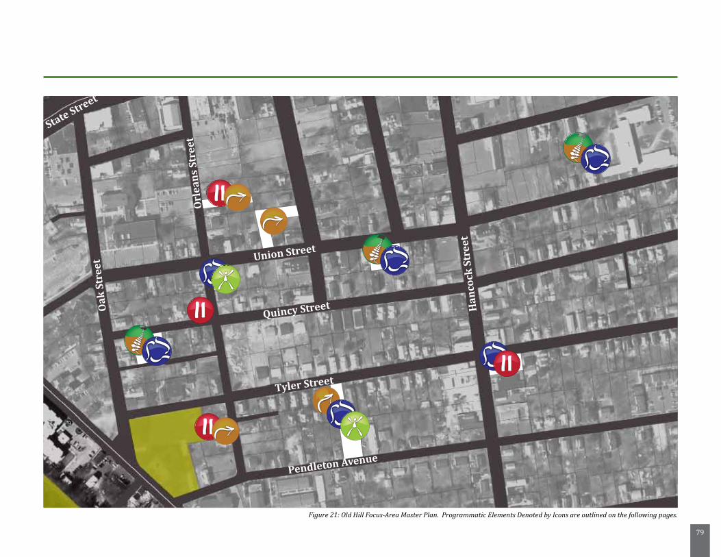
79
State Street
Union Street
Quincy Street
Tyler Street
Pendleton Avenue
Oak
Str
eet
Han
cock
Str
eet
Orl
ean
s St
reet
Figure 21: Old Hill Focus-Area Master Plan. Programmatic Elements Denoted by Icons are outlined on the following pages.
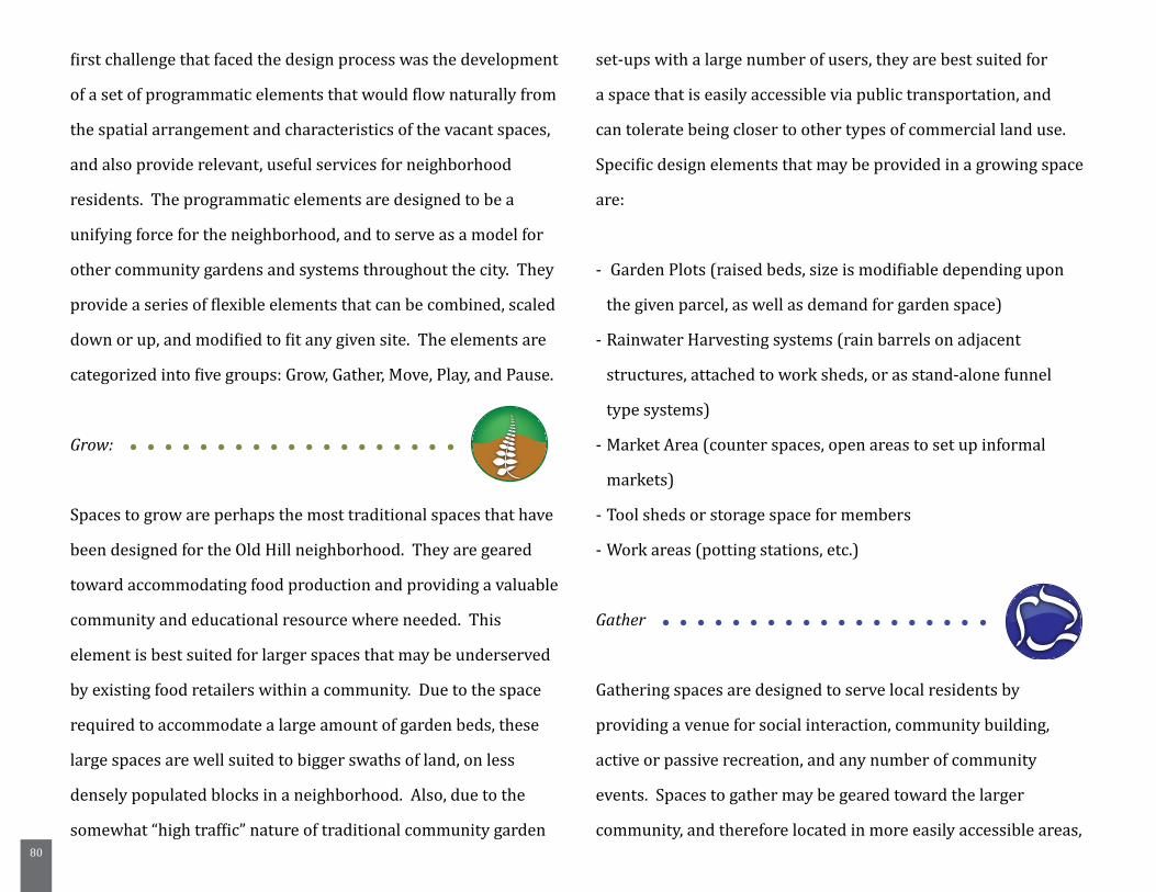
80
first challenge that faced the design process was the development
of a set of programmatic elements that would flow naturally from
the spatial arrangement and characteristics of the vacant spaces,
and also provide relevant, useful services for neighborhood
residents. The programmatic elements are designed to be a
unifying force for the neighborhood, and to serve as a model for
other community gardens and systems throughout the city. They
provide a series of flexible elements that can be combined, scaled
down or up, and modified to fit any given site. The elements are
categorized into five groups: Grow, Gather, Move, Play, and Pause.
Grow:
Spaces to grow are perhaps the most traditional spaces that have
been designed for the Old Hill neighborhood. They are geared
toward accommodating food production and providing a valuable
community and educational resource where needed. This
element is best suited for larger spaces that may be underserved
by existing food retailers within a community. Due to the space
required to accommodate a large amount of garden beds, these
large spaces are well suited to bigger swaths of land, on less
densely populated blocks in a neighborhood. Also, due to the
somewhat “high traffic” nature of traditional community garden
set-ups with a large number of users, they are best suited for
a space that is easily accessible via public transportation, and
can tolerate being closer to other types of commercial land use.
Specific design elements that may be provided in a growing space
are:
- Garden Plots (raised beds, size is modifiable depending upon
the given parcel, as well as demand for garden space)
- Rainwater Harvesting systems (rain barrels on adjacent
structures, attached to work sheds, or as stand-alone funnel
type systems)
- Market Area (counter spaces, open areas to set up informal
markets)
- Tool sheds or storage space for members
- Work areas (potting stations, etc.)
Gather
Gathering spaces are designed to serve local residents by
providing a venue for social interaction, community building,
active or passive recreation, and any number of community
events. Spaces to gather may be geared toward the larger
community, and therefore located in more easily accessible areas,
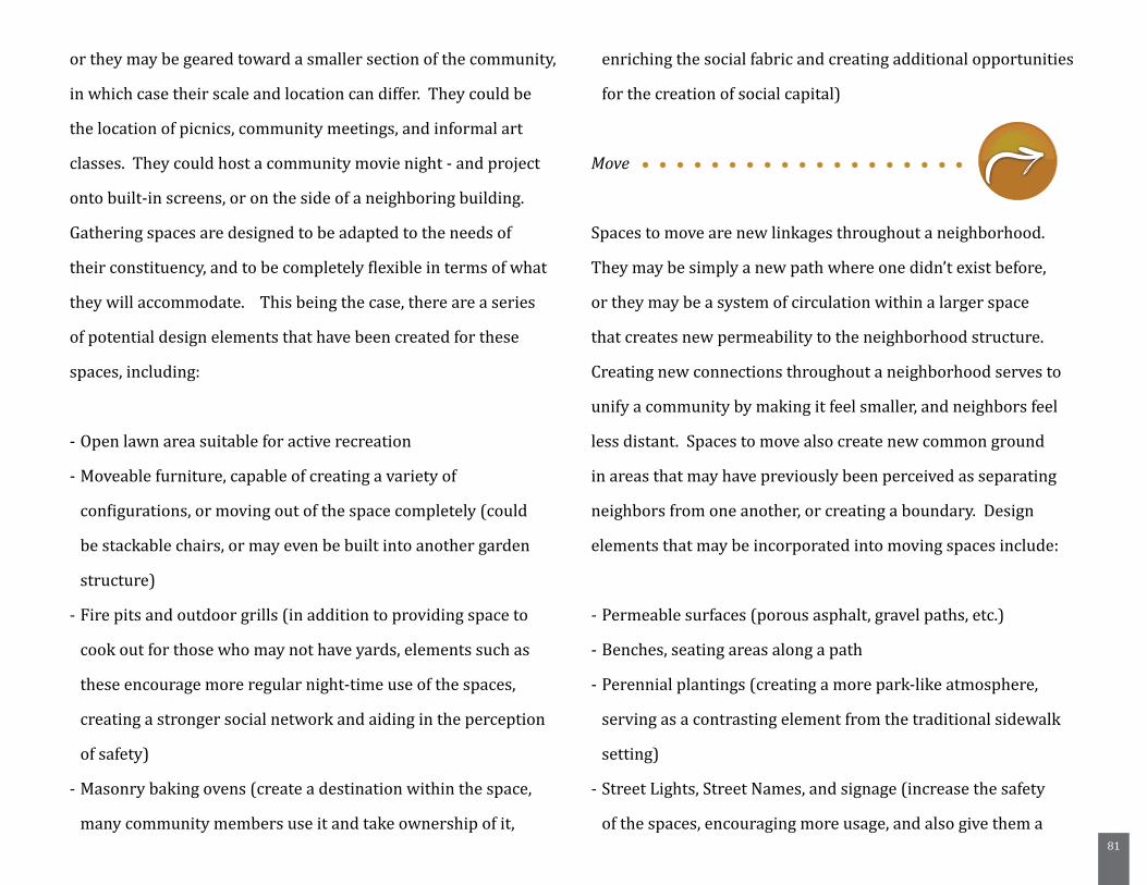
81
or they may be geared toward a smaller section of the community,
in which case their scale and location can differ. They could be
the location of picnics, community meetings, and informal art
classes. They could host a community movie night - and project
onto built-in screens, or on the side of a neighboring building.
Gathering spaces are designed to be adapted to the needs of
their constituency, and to be completely flexible in terms of what
they will accommodate. This being the case, there are a series
of potential design elements that have been created for these
spaces, including:
- Open lawn area suitable for active recreation
- Moveable furniture, capable of creating a variety of
configurations, or moving out of the space completely (could
be stackable chairs, or may even be built into another garden
structure)
- Fire pits and outdoor grills (in addition to providing space to
cook out for those who may not have yards, elements such as
these encourage more regular night-time use of the spaces,
creating a stronger social network and aiding in the perception
of safety)
- Masonry baking ovens (create a destination within the space,
many community members use it and take ownership of it,
enriching the social fabric and creating additional opportunities
for the creation of social capital)
Move
Spaces to move are new linkages throughout a neighborhood.
They may be simply a new path where one didn’t exist before,
or they may be a system of circulation within a larger space
that creates new permeability to the neighborhood structure.
Creating new connections throughout a neighborhood serves to
unify a community by making it feel smaller, and neighbors feel
less distant. Spaces to move also create new common ground
in areas that may have previously been perceived as separating
neighbors from one another, or creating a boundary. Design
elements that may be incorporated into moving spaces include:
- Permeable surfaces (porous asphalt, gravel paths, etc.)
- Benches, seating areas along a path
- Perennial plantings (creating a more park-like atmosphere,
serving as a contrasting element from the traditional sidewalk
setting)
- Street Lights, Street Names, and signage (increase the safety
of the spaces, encouraging more usage, and also give them a
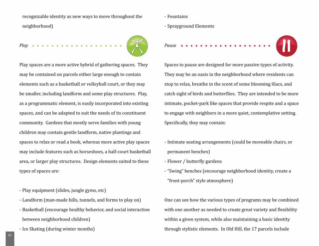
82
recognizable identity as new ways to move throughout the
neighborhood)
Play
Play spaces are a more active hybrid of gathering spaces. They
may be contained on parcels either large enough to contain
elements such as a basketball or volleyball court, or they may
be smaller, including landform and some play structures. Play,
as a programmatic element, is easily incorporated into existing
spaces, and can be adapted to suit the needs of its constituent
community. Gardens that mostly serve families with young
children may contain gentle landform, native plantings and
spaces to relax or read a book, whereas more active play spaces
may include features such as horseshoes, a half-court basketball
area, or larger play structures. Design elements suited to these
types of spaces are:
- Play equipment (slides, jungle gyms, etc)
- Landform (man-made hills, tunnels, and forms to play on)
- Basketball (encourage healthy behavior, and social interaction
between neighborhood children)
- Ice Skating (during winter months)
- Fountains
- Sprayground Elements
Pause
Spaces to pause are designed for more passive types of activity.
They may be an oasis in the neighborhood where residents can
stop to relax, breathe in the scent of some blooming lilacs, and
catch sight of birds and butterflies. They are intended to be more
intimate, pocket-park like spaces that provide respite and a space
to engage with neighbors in a more quiet, contemplative setting.
Specifically, they may contain:
- Intimate seating arrangements (could be moveable chairs, or
permanent benches)
- Flower / butterfly gardens
- “Swing” benches (encourage neighborhood identity, create a
“front-porch” style atmosphere)
One can see how the various types of programs may be combined
with one another as needed to create great variety and flexibility
within a given system, while also maintaining a basic identity
through stylistic elements. In Old Hill, the 17 parcels include
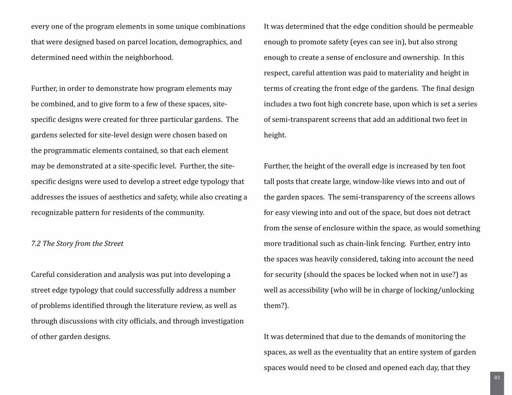
83
every one of the program elements in some unique combinations
that were designed based on parcel location, demographics, and
determined need within the neighborhood.
Further, in order to demonstrate how program elements may
be combined, and to give form to a few of these spaces, site-
specific designs were created for three particular gardens. The
gardens selected for site-level design were chosen based on
the programmatic elements contained, so that each element
may be demonstrated at a site-specific level. Further, the site-
specific designs were used to develop a street edge typology that
addresses the issues of aesthetics and safety, while also creating a
recognizable pattern for residents of the community.
7.2 The Story from the Street
Careful consideration and analysis was put into developing a
street edge typology that could successfully address a number
of problems identified through the literature review, as well as
through discussions with city officials, and through investigation
of other garden designs.
It was determined that the edge condition should be permeable
enough to promote safety (eyes can see in), but also strong
enough to create a sense of enclosure and ownership. In this
respect, careful attention was paid to materiality and height in
terms of creating the front edge of the gardens. The final design
includes a two foot high concrete base, upon which is set a series
of semi-transparent screens that add an additional two feet in
height.
Further, the height of the overall edge is increased by ten foot
tall posts that create large, window-like views into and out of
the garden spaces. The semi-transparency of the screens allows
for easy viewing into and out of the space, but does not detract
from the sense of enclosure within the space, as would something
more traditional such as chain-link fencing. Further, entry into
the spaces was heavily considered, taking into account the need
for security (should the spaces be locked when not in use?) as
well as accessibility (who will be in charge of locking/unlocking
them?).
It was determined that due to the demands of monitoring the
spaces, as well as the eventuality that an entire system of garden
spaces would need to be closed and opened each day, that they
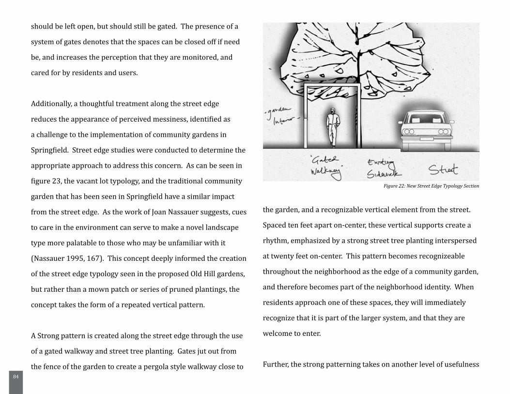
84
should be left open, but should still be gated. The presence of a
system of gates denotes that the spaces can be closed off if need
be, and increases the perception that they are monitored, and
cared for by residents and users.
Additionally, a thoughtful treatment along the street edge
reduces the appearance of perceived messiness, identified as
a challenge to the implementation of community gardens in
Springfield. Street edge studies were conducted to determine the
appropriate approach to address this concern. As can be seen in
figure 23, the vacant lot typology, and the traditional community
garden that has been seen in Springfield have a similar impact
from the street edge. As the work of Joan Nassauer suggests, cues
to care in the environment can serve to make a novel landscape
type more palatable to those who may be unfamiliar with it
(Nassauer 1995, 167). This concept deeply informed the creation
of the street edge typology seen in the proposed Old Hill gardens,
but rather than a mown patch or series of pruned plantings, the
concept takes the form of a repeated vertical pattern.
A Strong pattern is created along the street edge through the use
of a gated walkway and street tree planting. Gates jut out from
the fence of the garden to create a pergola style walkway close to
the garden, and a recognizable vertical element from the street.
Spaced ten feet apart on-center, these vertical supports create a
rhythm, emphasized by a strong street tree planting interspersed
at twenty feet on-center. This pattern becomes recognizeable
throughout the neighborhood as the edge of a community garden,
and therefore becomes part of the neighborhood identity. When
residents approach one of these spaces, they will immediately
recognize that it is part of the larger system, and that they are
welcome to enter.
Further, the strong patterning takes on another level of usefulness
Figure 22: New Street Edge Typology Section
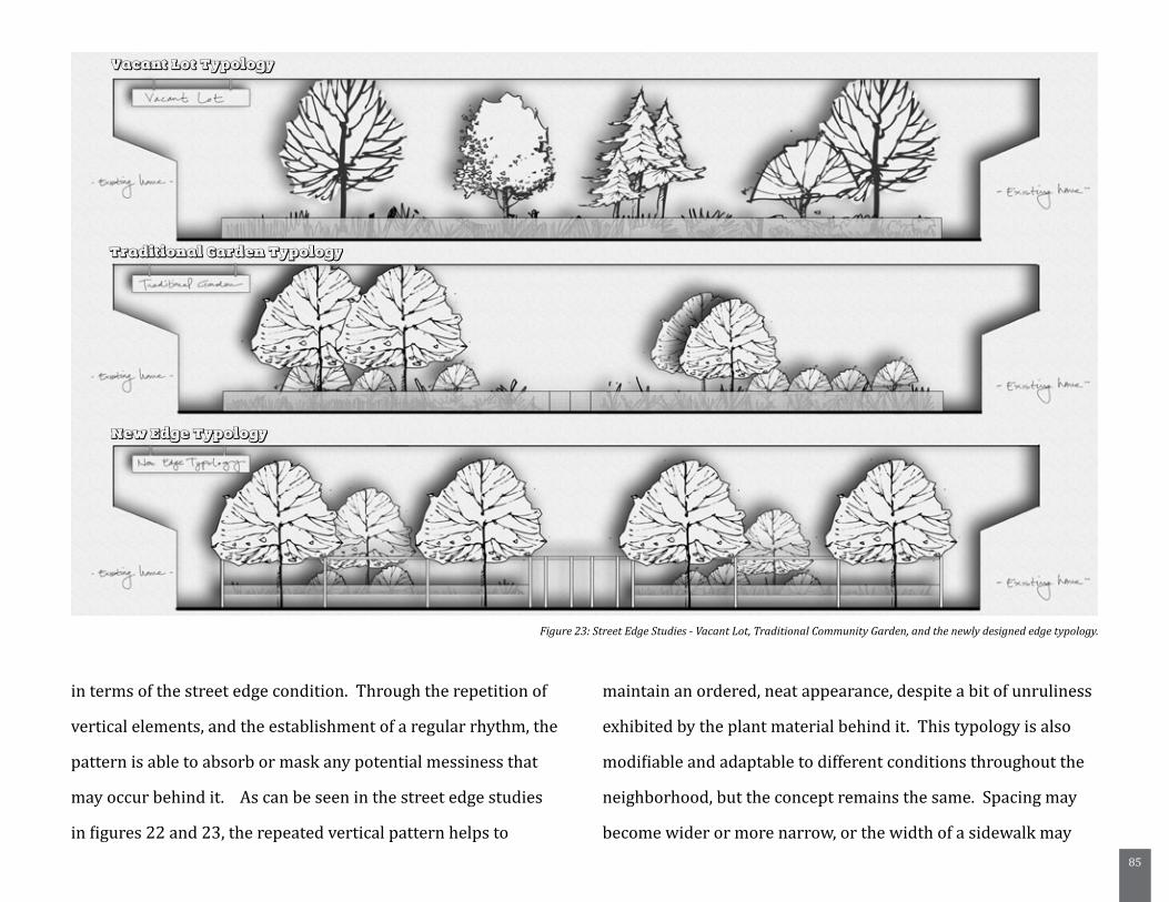
85
in terms of the street edge condition. Through the repetition of
vertical elements, and the establishment of a regular rhythm, the
pattern is able to absorb or mask any potential messiness that
may occur behind it. As can be seen in the street edge studies
in figures 22 and 23, the repeated vertical pattern helps to
maintain an ordered, neat appearance, despite a bit of unruliness
exhibited by the plant material behind it. This typology is also
modifiable and adaptable to different conditions throughout the
neighborhood, but the concept remains the same. Spacing may
become wider or more narrow, or the width of a sidewalk may
Vacant Lot Typology
Traditional Garden Typology
New Edge Typology
Figure 23: Street Edge Studies - Vacant Lot, Traditional Community Garden, and the newly designed edge typology.
86
preclude the use of the gated structures, but the recognizable
element of the pattern still creates a cared-for, ordered and
unified appearance.
7.3 Site-Specific Designs
Three site-specific designs were created for parcels in the Old
Hill neighborhood, with the goal of demonstrating a number of
the programmatic elements, as well as the functional aesthetics
of the street edge typology. These designs are intended to
provide a conceptual framework for what spaces in the Old
Hill neighborhood might contain, and how they can fit into the
existing urban fabric, and contribute to a strong neighborhood
identity. Three sites were chosen for design based upon a need
to demonstrate each of the programmatic elements, and to
show how they may fit on parcels of different sizes, shapes, and
contexts within the neighborhood. The parcels that were chosen
for detailed design work are highlighted below (Insert Map with
Designed Parcels Highlighted).
Site One: Quincy Street Community Garden
The Quincy Street Community Garden design incorporates both
growing and gathering elements into the space. As it is close to
the existing bus stop on Walnut Street, it is easily accessible both
from within the neighborhood on foot, or from further out via
public transportation. It incorporates the street edge typology
discussed above, as well as a permeable entry space, fruit tree
bosque, planting station, and an open configurable space for a
variety of community events. Further, the space was designed to
accommodate as many raised garden beds as possible, totaling 46
5’ by 10’ beds.
Upon approaching the garden, one first encounters the entry
area, which has been designed to include free-standing rainwater
harvesters, which feed into a cistern system below the entryway,
allowing rainwater to be captured and pumped back up to
water the raised beds within the garden. Additionally, the space
includes a series of vertical supports that serve to divide either
side in two, and can be used as supports for tables on which
gardeners can sell produce or crafted goods right from their own
garden. When the space is in use as an informal market, it brings
the presence of the garden right out onto the street, and it brings
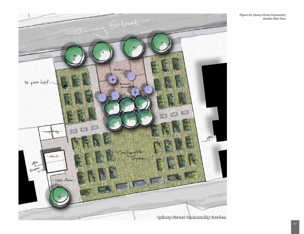
87
Quincy Street Community Garden
Figure 24: Quincy Street Community Garden Plan View
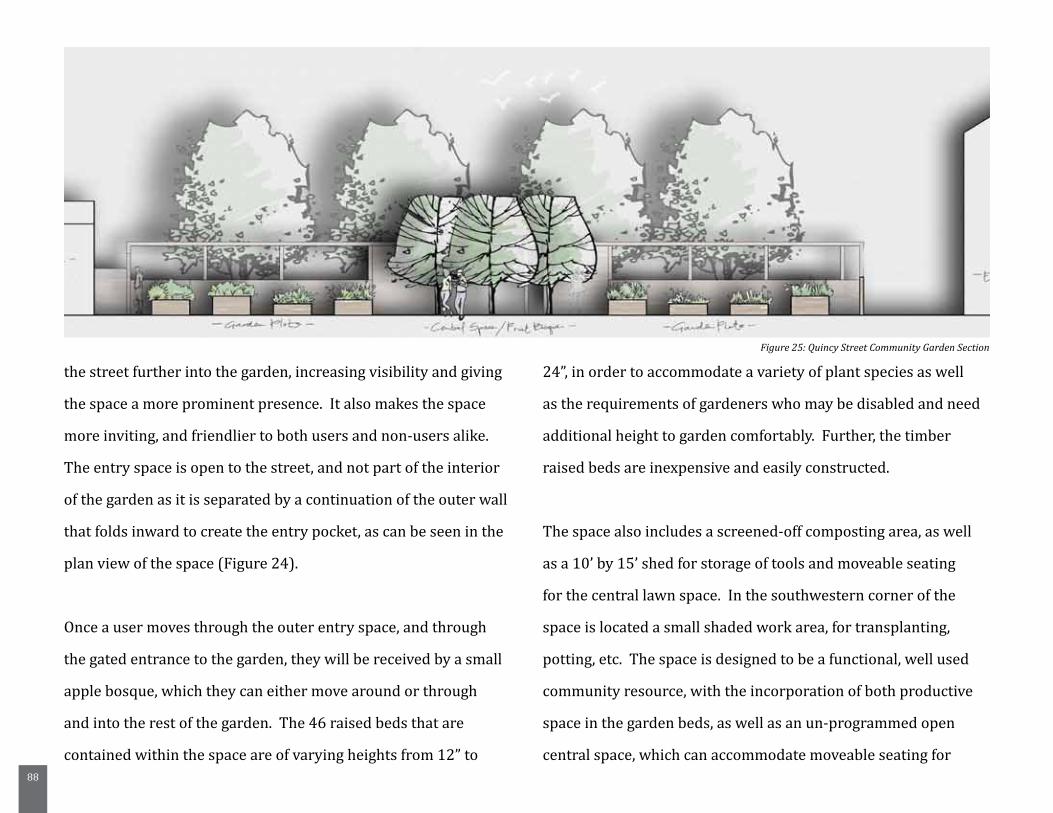
88
the street further into the garden, increasing visibility and giving
the space a more prominent presence. It also makes the space
more inviting, and friendlier to both users and non-users alike.
The entry space is open to the street, and not part of the interior
of the garden as it is separated by a continuation of the outer wall
that folds inward to create the entry pocket, as can be seen in the
plan view of the space (Figure 24).
Once a user moves through the outer entry space, and through
the gated entrance to the garden, they will be received by a small
apple bosque, which they can either move around or through
and into the rest of the garden. The 46 raised beds that are
contained within the space are of varying heights from 12” to
24”, in order to accommodate a variety of plant species as well
as the requirements of gardeners who may be disabled and need
additional height to garden comfortably. Further, the timber
raised beds are inexpensive and easily constructed.
The space also includes a screened-off composting area, as well
as a 10’ by 15’ shed for storage of tools and moveable seating
for the central lawn space. In the southwestern corner of the
space is located a small shaded work area, for transplanting,
potting, etc. The space is designed to be a functional, well used
community resource, with the incorporation of both productive
space in the garden beds, as well as an un-programmed open
central space, which can accommodate moveable seating for
Figure 25: Quincy Street Community Garden Section
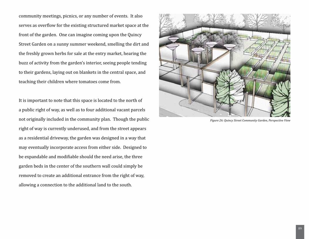
89
community meetings, picnics, or any number of events. It also
serves as overflow for the existing structured market space at the
front of the garden. One can imagine coming upon the Quincy
Street Garden on a sunny summer weekend, smelling the dirt and
the freshly grown herbs for sale at the entry market, hearing the
buzz of activity from the garden’s interior, seeing people tending
to their gardens, laying out on blankets in the central space, and
teaching their children where tomatoes come from.
It is important to note that this space is located to the north of
a public right of way, as well as to four additional vacant parcels
not originally included in the community plan. Though the public
right of way is currently underused, and from the street appears
as a residential driveway, the garden was designed in a way that
may eventually incorporate access from either side. Designed to
be expandable and modifiable should the need arise, the three
garden beds in the center of the southern wall could simply be
removed to create an additional entrance from the right of way,
allowing a connection to the additional land to the south.
Figure 26: Quincy Street Community Garden, Perspective View
90
Site Two: Orleans Street Community Garden
The garden space located at the corner of Orleans and Union
Streets was designed to be a space for gathering and playing. As
it is located adjacent to an existing apartment building, it was
also deemed necessary that it should mainly serve residents of
its immediate context, and provide them an outdoor space that
could accommodate a wide range of uses, as an extension of their
indoor living space.
The design incorporates the street edge typology created for
the Old Hill neighborhood, as well as an entry bosque just inside
the gates located on the northwest corner. The bosque provides
a shaded area for relaxing, as well as two steps that provide
informal seating space. The large, configurable lawn space is
intended to serve any one of a variety of uses, from community
meetings, birthday parties, and movie nights, to picnics and
playing catch. As a space such as this would ideally incorporate
feedback from the surrounding residents as to the different
elements that should be included under the larger play / gather
program designation, and the time constraints of this project have
not allowed the researcher to gather such information, the space
was designed to allow for any number of additional elements.
By lowering the central space even 1’, the sense of enclosure
within the garden is greatly enhanced, and the view from within
the garden out to the street becomes much more focused on
the street tree plantings and the additional enclosure that
they provide. This sense of enclosure is well articulated by the
perspective view that can be seen in figure 29. Further, the wall
that is created to retain the edges of the space also creates a
small, 3’ wide continuous bed that can be planted with a variety
of species either edible or decorative, and can serve as informal
seating around the perimeter of the garden.
A larger planted buffer, 10’ wide is created on the southern edge
of the garden, allowing an impressive existing oak to remain and
add character to the space, as well as to provide an additional
buffer for residents on the first floor of the building. This bed
could become a shade garden, with varieties of fern and hosta,
creating a cool shady spot on hot summer afternoons.
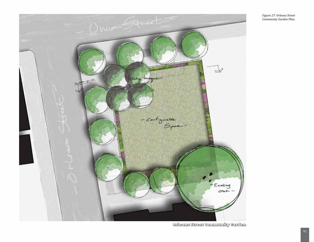
91
Figure 27: Orleans Street Community Garden Plan.
Orleans Street Community Garden
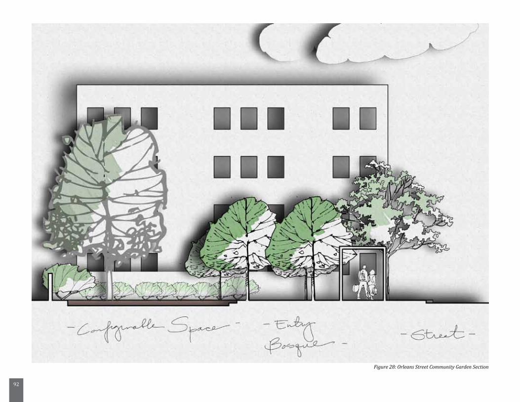
92
Figure 28: Orleans Street Community Garden Section
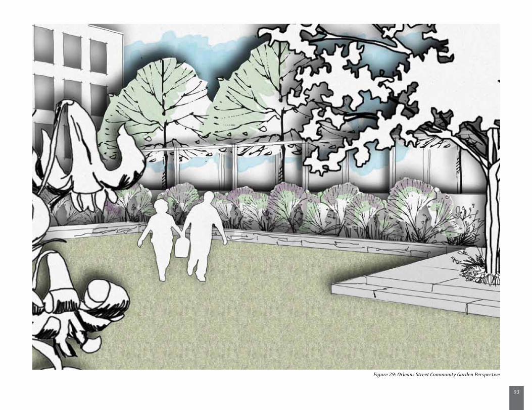
93
Figure 29: Orleans Street Community Garden Perspective
94
Site Three: Dunbar Community Garden
The third space that has been designed is intended to
demonstrate the move and pause program elements, creating
a space that can be used to increase access to the existing
community center, and to act as an extension of the center itself.
At approximately 30’ wide by 180’ long, the space is incredibly
linear, and therefore presented a challenge to creating spaces that
would be engaging and draw users in, while also providing a new
way to move throughout the Old Hill neighborhood.
Upon approaching the space from the western side, where the
existing community center is located, users will first encounter
a small entry courtyard, framed by the new street edge typology
on the outside, as well as stand-alone rainwater harvesters and
a small decorative bosque on the inside. Permeable pavers
in this area create a space that may be used as both an entry
to the garden itself, or as the location of small scale events or
receptions.
The gathering space dissolves to the east into a more linear
system of a 4’ path and a series of raised bed planters, again
varying in height. In the center of the space is a small shade
garden, with integrated seat walls that allow for gardeners or
passersby to pause and enjoy the shade. The system of path and
planters continues further to the east, and an evergreen buffer
contains the eastern edge of the garden, allowing for potential
connection down the existing property line, and out through
additional vacant parcels to Stebbins and Union Streets.
Thus, even a long, narrow and seemingly difficult space can be
designed to provide functional outdoor space, a new connection
through the neighborhood, the ability to grow fresh, healthy food,
and a safe, shady place to relax on a walk home from school.
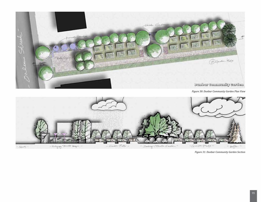
95
Figure 30: Dunbar Community Garden Plan View
Figure 31: Dunbar Community Garden Section
Dunbar Community Garden
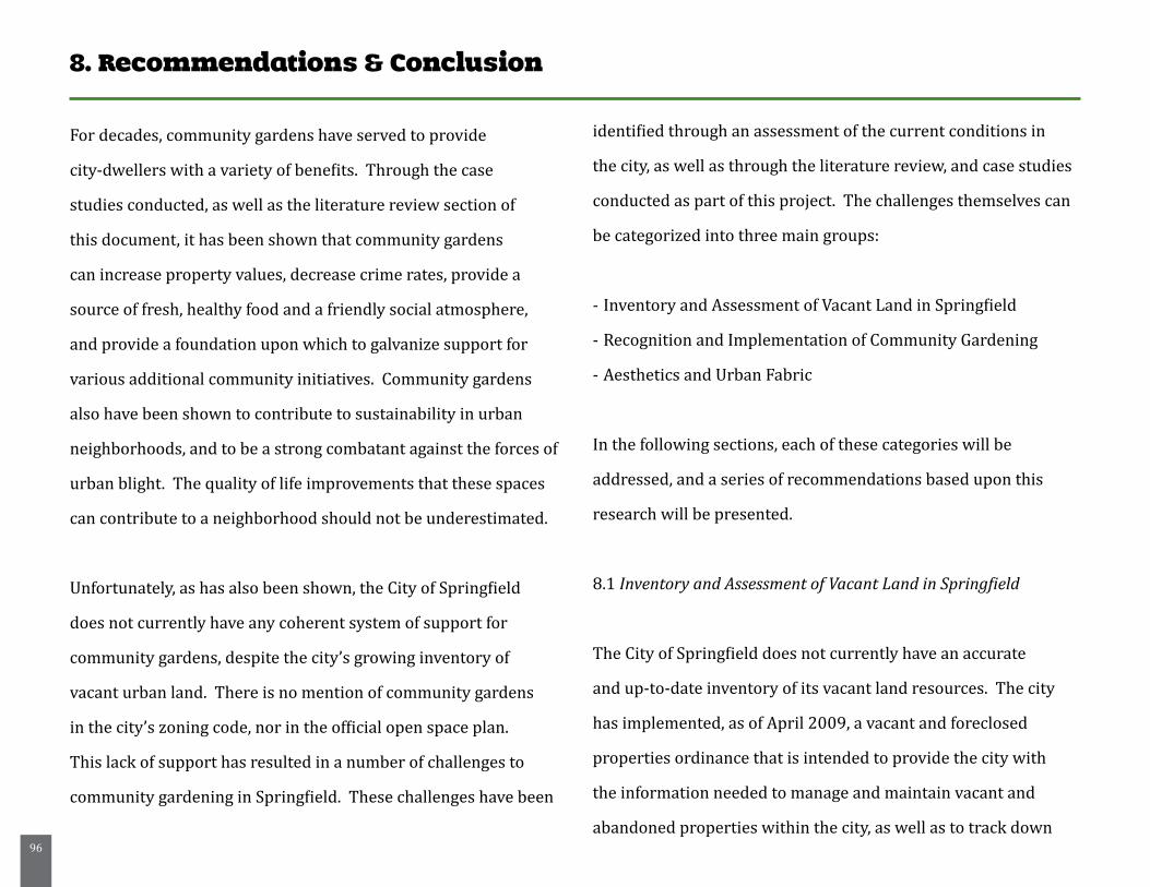
96
8. Recommendations & Conclusion
For decades, community gardens have served to provide
city-dwellers with a variety of benefits. Through the case
studies conducted, as well as the literature review section of
this document, it has been shown that community gardens
can increase property values, decrease crime rates, provide a
source of fresh, healthy food and a friendly social atmosphere,
and provide a foundation upon which to galvanize support for
various additional community initiatives. Community gardens
also have been shown to contribute to sustainability in urban
neighborhoods, and to be a strong combatant against the forces of
urban blight. The quality of life improvements that these spaces
can contribute to a neighborhood should not be underestimated.
Unfortunately, as has also been shown, the City of Springfield
does not currently have any coherent system of support for
community gardens, despite the city’s growing inventory of
vacant urban land. There is no mention of community gardens
in the city’s zoning code, nor in the official open space plan.
This lack of support has resulted in a number of challenges to
community gardening in Springfield. These challenges have been
identified through an assessment of the current conditions in
the city, as well as through the literature review, and case studies
conducted as part of this project. The challenges themselves can
be categorized into three main groups:
- Inventory and Assessment of Vacant Land in Springfield
- Recognition and Implementation of Community Gardening
- Aesthetics and Urban Fabric
In the following sections, each of these categories will be
addressed, and a series of recommendations based upon this
research will be presented.
8.1 Inventory and Assessment of Vacant Land in Springfield
The City of Springfield does not currently have an accurate
and up-to-date inventory of its vacant land resources. The city
has implemented, as of April 2009, a vacant and foreclosed
properties ordinance that is intended to provide the city with
the information needed to manage and maintain vacant and
abandoned properties within the city, as well as to track down
97
owner’s of blighted parcels and hold them responsible for the
upkeep of the properties. As this ordinance is still in its infancy,
its efficacy cannot yet be judged, although it has been relayed to
this researcher anecdotally by city employees that it is not yet
meeting with great compliance.
As a top priority, the city needs to take a comprehensive
inventory of its vacant and foreclosed property. Until this
inventory is complete and up-to-date, the city cannot move
forward with any type of comprehensive management strategy,
or the implementation of community gardens as urban infill.
Further, once a complete inventory is available, the city should
employ an evaluative approach to the management of its
vacant land inventory, so as to best decide where community
gardens should be established, and where other redevelopment
opportunities are best suited. A framework for this approach is
presented in chapter 5 of this document.
In the future, the city should also consider creating a community
garden coordinator position. Though staff limitations and budget
constraints may make this an impossibility at first, it should most
definitely be on the city’s radar as a long term goal. A community
garden coordinator could work to identify opportunities for
gardens as infill within the city, as well as to advocate for the
creation of opportunities for gardening in future development
initiatives, through incentives such as tax cuts to developers who
include community gardens in their plans.
8.2 Recognition and Implementation of Community Gardening
Community gardening must be acknowledged by the City of
Springfield as an appropriate and productive use of urban space.
There is currently no acknowledgement of community gardening
in the city’s Open Space Plan, and there is no accommodation
for community gardening in the city’s zoning code. The city
should take steps to update its zoning code to explicitly include
community gardens, and to make their implementation possible
on vacant land in all areas of Springfield. Further, the city should
begin to take a longer view of the role that community gardens
can play in Springfield. Though this project has focused on
community gardens as an infill strategy for Springfield, their
incorporation should not merely be considered a salve for
98
disadvantaged neighborhoods. The city should consider the
incorporation of community gardens into long-term land use
planning and development initiatives. Community gardens
should be recognized as part of the overall health of the city, and
city officials and planners should begin to acknowledge the role
of community gardens in achieving their larger goals, such as
sustainability, food security, and neighborhood revitalization.
The city must create a set of goals that will serve as the backbone
of an overall system of support for community gardening in
Springfield.
Suggested Goals and Objectives
- (Goal) Establish a system of small-scale urban agriculture in the
City of Springfield through support for community gardening.
- (Goal) Develop a garden culture in Springfield through
education and awareness programs that will expand the
number of community gardeners and familiarize residents and
families with environmental and food security issues, as well as
the community and health benefits of gardening.
- (Goal) Develop and program each community garden as an
open space resource for its surrounding context, taking into
consideration the needs and desires of residents
- (Objective) Seek out and develop partnerships with non-profit
organizations, as well as educational institutions in the region to
create a system of resources and support for garden initiatives
- (Objective) Inventory and assess the current vacant land
within Springfield as a means of evaluating parcels for use as
community gardens.
- (Objective) Design and construct a series of community garden
clusters throughout Springfield as a means of developing model,
sustainable, safe and healthy neighborhoods that provide
residents with a wealth of social and recreational opportunity,
increase urban green, and improve the overall quality of life
within the city (adapted from NYRP.org).
8.3 Aesthetics and Urban Fabric
Though community gardens provide a vast number of benefits
to neighborhoods and residents, they are often considered
to be eyesores, and therefore suffer from a bit of an “image
problem”. This has resulted in a largely negative view of garden
spaces themselves, and serves as a challenge to their successful
implementation. The aesthetics of garden spaces need to be more
carefully considered, and a series of guidelines should be created
99
to ensure that each garden space that is developed is contributing
to the aesthetic quality of a neighborhood, not detracting from it.
The design development chapter of this document has discussed
a number of strategies for mitigating the aesthetic implications
of traditional community gardens, and it is recommended that
these strategies, program elements, and design concepts can be
adapted into a series of guidelines for the design of community
gardens in Springfield. Guidelines should be flexible enough to
allow for adaptation under a variety of conditions, in a variety
of neighborhoods, but should maintain a unified appearance.
Further, Springfield should leverage the resource that it has in the
University of Massachusetts, Amherst’s Landscape Architecture
students should further design considerations require attention.
8.4 Recommendations for Future Research
Future research on the potential for community gardening in
Springfield would best be focused on the logistical and financial
frameworks necessary to aid the city in the creation of said
spaces. This report has served to identify a number of the issues
presently challenging gardens within the city, and attempted
to provide a spatial tool and a design oriented solution to their
implementation, as well as recommendations based upon case
study research.
Additional research could also include food systems analysis,
focusing on the potential for small scale urban agriculture to
satisfy some of the unmet food need within the city, or could
take a more theoretical approach and focus on the creation of a
“garden culture” within the city by looking in-depth at various
successful community gardening programs.
8.5 Conclusion
This project has sought to explore the possibilities for
incorporation of community gardens as an urban infill strategy
in Springfield, Massachusetts. Through a comprehensive
literature review, it has provided a framework for understanding
the complex relationship between neighborhood conditions,
vacancy, and urban blight. It has demonstrated the relationship
between disadvantaged urban neighborhoods and the health and
community capacity of their residents, and provided an overview
of research related to the ways that community gardens can aid in
their revitalization.
Further, this project has created a valuable critical assessment
100
framework for the city of Springfield, as well as a wealth of
information related to the current state of vacant land within the
city. It has provided an in-depth assessment of one particular
urban neighborhood, Old Hill, and shown how thoughtful
assessment and utilization of current city-owned land resources
could aid in the neighborhood’s revitalization. Additionally,
this project has provided a programmatic framework for how
a system of community gardens within Springfield may be
structured, and a series of well thought-out design elements
that are capable of adapting and responding to the challenges
of a variety of conditions and contexts. It has also provided
three detailed designs that communicate a design vision for
these spaces in Springfield, capable of strengthening community
identity, improving their perceived value, and giving shape to the
idea of small scale urban agriculture within the city.
In conclusion, this project has provided an overview of
the current conditions within Springfield, illuminated the
relationship between vacancy and urban blight, and proposed
a strategy for implementing community gardens as an infill to
alleviate the problems associated with urban vacancy. A wealth
of research, a thoughtful assessment framework, a design
strategy and a series of recommendations have been offered,
and it is hoped that community leaders, planners, students, and
residents will work together to ensure that community gardening
has a future in the city of Springfield.
101
References:
Appleyard, D. 1979. The environment as a social symbol: Within a theory of environmental action and perception. Journal of the American Planning Association 45, (2): 143.
Armstrong, Donna. 2000. A survey of community gardens in upstate new york: Implications for health promotion and community development. Health & Place 6, (4) (12/1): 319-27.
Bjornson, M. R. 2006. Working in community gardens. Lawn and Garden Retailer, 18-24. Retrieved February 21, 2010, from http://www.lgrmag.com/articles/workingincommunity.pdf
Brogan, D. R. 1980. Physical environment correlates of psychosocial health among urban residents. American Journal of Community Psychology 8, (5): 507.
Brown, Kate H., and Andrew L. Jameton. 2000. Public health implications of urban agriculture. Journal of Public Health Policy 21, (1): 20-39.
Cecil Group, with Tai Soo Kim Partners. 2004. Old Hill Neighborhood Master Plan. Retrieved December 5, 2009 from http://www.springfieldcityhall.com/planning/old-hill-plan.0.html
City of Seattle. 1992. Resolution 28610. Retrieved February 23, 2010, from http://www.preventioninstitute.org/sa/policies/pdftext/Seattle_p-patch.pdf
City of Seattle, Department of Neighborhoods. P-Patch Fact Sheet. Retrieved March 21, 2010, from http://www.seattle.gov/neighborhoods/ppatch/documents/FactSheet2010.pdf
City of Seattle, Department of Neighborhoods. P-Patch
Community Garden Program. Retrieved March 21, 2010 from http://www.seattle.gov/neighborhoods/ppatch/
City of Springfield. 2009. Open Space and Recovery Action Plan. Retrieved December 4, 2009, from http://www.springfieldcityhall.com/planning/fileadmin/Planning_files/Open_Space_Plan_2008_Final.pdf
Corbin, Carla I. 2003. Vacancy and the landscape: Cultural context and design response. Landscape Journal 22, (1) (03): 12.
Corburn, Jason, Jeffrey Osleeb, and Michael Porter. 2006. Urban asthma and the neighbourhood environment in new york city. Health & Place 12, (2) (6): 167-79.
Deelstra, T. and H. Girardet .2000. “Urban agriculture and sustainable cities.” In N. Bakker, M. Dubelling, S. Gundel, V. Sabel-Koschella, and A. Zeeuw (eds.), Growing Cities, Growing Food: Urban Agriculture on the Policy Agenda. Feldafing, Germany: Food and Agriculture Development Centre (ZEL).
Dickinson, J., Duma, S., Paulsen, H., Rilveria, L., Twiss, J. and Weinman, T. 2003. Community gardens: lessons learned from California healthy cities and communities. American Journal of Public Health, 93, 1435–1438.
Enns, J., Rose, A., de Vries, J., & Hayes, J. 2008. A seat at the table: Resource guide for local governments to promote food secure communities. Retrieved February 19, 2010, from http://www.phsa.ca/NR/rdonlyres/76D687CF-6596-46FE-AA9A- A536D61FB038/29298/PHSAreportaseatatthetable4.pdf
Federal Reserve Bank of Boston. 2009. Towards a More Prosperous Springfield, Massachusetts: Project Introduction and
102
Motivation.
Federal Reserve System and the Brookings Institution. 2008. The Enduring Challenge of Concentrated Poverty in America. Accessed 10/14/2009 at http://www.frbsf.org/cpreport/docs/cp_fullreport.pdf
Francis, Mark. 1987. Some different meanings attached to a city park and community gardens. Landscape Journal 6, (2) (September 1): 101-12.
Genesee County Land Bank. 2010. www.thelandbank.org. Accessed March 19, 2010.
Glover, T. D. 2003. The story of the queen anne memorial garden: Resisting a dominant cultural narrative. Journal of Leisure Research 35, (2): 190.
Hall, D. 1996. Community gardens as an urban planning issue (Master’s thesis, University of British Columbia, 1996). Retrieved January 28, 2010, from http://www.cityfarmer.org/dianaCGplanning.html
Hancock, Trevor. 2001. People, partnerships and human progress: Building community capital. Health Promotion International 16, (3) (September 1): 275-80.
Holland, Leigh. 2004. Diversity and connections in community gardens: A contribution to local sustainability. Local Environment 9, (3) (06): 285-305.
Immergluck, D. 2006. The external costs of foreclosure: The impact of single-family mortgage foreclosures on property values. Housing Policy Debate 17, (1): 57.
Immergluck, Dan, and Geoff Smith. 2006. The impact of single-family mortgage foreclosures on neighborhood crime. Housing Studies 21, (6) (11): 851-66.
Kaethler, T. M. 2006. Growing space: The potential for urban agriculture in the city of Vancouver (Master’s thesis, University of British Columbia). Retrieved February 12, 2010, from http://www.city.vancouver.bc.ca/commsvcs/socialplanning/initiatives/foodpolicy/ tools/pdf/Growing_Space_Rpt.pdf
Kraut, David. 1999. Hanging out the no vacancy sign: Eliminating the blight of vacant buildings from urban areas. New York University Law Review 74, (4).
Kuo, Frances E., and William C. Sullivan. 2001. Environment and crime in the inner city: Does vegetation reduce crime? Environment and Behavior 33, (3) (May 1): 343-67.
Librizzi, L. 1999. Comprehensive plans, zoning regulations, open space policies and goals concerning community gardens and open green space from the cities of Seattle, Berkeley, Boston, and Chicago. Retrieved February 23, 2010, from http://7d8ca58ce9d1641c9251f63b606b91782998fa39.gripelements.com/docs/cg_ policies.pdf
Malakoff, D. 1995. What good is community greening? In Community greening review (pp. 16-20). Columbus, OH: American Community Gardening Association. Retrieved February 19, 2010, from http://7d8ca58ce9d1641c9251f63b606b91782998fa39.gripelements.com/docs/Wh atGoodisCommunityGreening.pdf
Mougeot, L. J. A. 2006. Growing better cities: Urban agriculture for sustainable development [Electronic version]. Retrieved February 19, 2010, from http://www.idrc.ca/openebooks/226-0/
Nassauer, J. I. 1995. Messy ecosystems, orderly frames. Landscape Journal 14, 161.
National Vacant Properties Campaign, Vacant Properties: The True Costs to Communities (Washington, DC: National Vacant
103
Properties Campaign, 2005).
National Vacant Properties Campaign, Cleveland at the Crossroads. (Washington, DC: National Vacant Properties Campaign, 2005).
P-Patch Trust. 2010. P-Patch Trust, Building Gardens, Growing Communities. Retrieved March 23, 2010 from http://www.ppatchtrust.org/
Pennsylvania Horticultural Society. 2006. Community gardens. Retrieved February 4, 2010, from http://www.pennsylvaniahorticulturalsociety.org/phlgreen/community_gardens.pdf
Ross, Catherine E. 2000. Neighborhood disadvantage and adult depression. Journal of Health and Social Behavior 41, (2) (Jun.): 177-87.
Schmelzkopf, K. 2002. Incommensurability, land use, and the right to space: Community gardens in new york city 1. Urban Geography 23, (4): 323.
Schmelzkopf, Karen. 1995. Urban community gardens as contested space. Geographical Review 85, (3) (Jul.): 364-81.
Schuetz, Jenny, Vicki Been, and Ingrid Gould Ellen. 2008. Neighborhood effects of concentrated mortgage foreclosures. Journal of Housing Economics 17, (4) (12): 306-19.
Schukoske, J. E. 2000. Elements to include in a community garden ordinance. In Community greening review (p. 8). Columbus, OH: American Community Gardening Association. Retrieved February 19, 2010, from http://7d8ca58ce9d1641c9251f63b606b91782998fa39.gripelements.com/docs/CG _Ordinances.pdf
Skogan, Wesley G. 1992. Disorder and decline : Crime and the spiral of decay in american neighborhoods. Berkeley: University
of California Press.
Spelman, W. 1993. Abandoned buildings: Magnets for crime? Journal of Criminal Justice 21, (5): 481.
Stocker, L. 1998. The significance and praxis of community-based sustainability projects: Community gardens in western australia. Local Environment 3, (2): 179.
Temple University Center for Public Policy and Eastern Pennsylvania Organizing Project. “Blight Free Philadelphia: A Public-Private Strategy to Create and Enhance Neighborhood Value.” Philadelphia, 2001.
Urban Agriculture Task Force (2006). Urban Agriculture in Providence: Growing Our Community by Growing Good Food.” UATF Publishing, Providence. Retrieved February 19, 2010, from http://www.dem.ri.gov/programs/bnatres/agricult/pdf/urbanag.pdf
Vancouver Park Board. 2005. Community gardens policy. Retrieved October 12, 2007, from http://vancouver.ca/parks/board/2005/050919/a3_community_gardens_policy_sept05.pdf
Voicu, Ioan, and Vicki Been. 2008. The effect of community gardens on neighboring property values. Real Estate Economics 36, (2) (Summer2008): 241-83.
Wakefield, Sarah, Fiona Yeudall, Carolin Taron, Jennifer Reynolds, and Ana Skinner. 2007. Growing urban health: Community gardening in south-east toronto. Health Promotion International 22, (2) (June 1): 92-101.
Wilson, James Q. and George L. Kelling. “Making Neighborhoods Safe.” Atlantic Monthly February 1989.