current conditions of groundwater resources … conditions of groundwater resources development and...
TRANSCRIPT

European Water 54: 43-68, 2016. © 2016 E.W. Publications
Current conditions of groundwater resources development and related problems in the Republic of Cameroon, West Africa
C. Defo1*, A.K. Mishra1, B.P.K. Yerima2, P.B. Mabou3, A.A. Ako4 and T. Fonkou5 1 Water Technology Centre, Indian Agricultural Research Institute, New Delhi, India 2 Faculty of Agronomy and Agricultural Science, University of Dschang, Cameroon 3 Department of Geography, University of Yaoundé 1, Cameroon 4 Institute for Geological and Mining Research, Yaoundé, Cameroon 5 Faculty of Science, University of Dschang, Cameroon * e-mail: [email protected] Abstract: In the republic of Cameroon, groundwater is distributed for community water supply from water points (WP) (spring
catchments, wells and boreholes) and Mini Water Conveyances (MWC) for middle-sized urban and rural areas. Groundwater resources are abundant and erratically distributed in different aquifers in the country while water supply infrastructures are still unsatisfactory. Many constraints such as the weakness of institutions and legal framework constitute the roots of poor management of groundwater resources which is structurally overdrawn. This article primarily describes the groundwater resources availability, its use and its quality in the Republic of Cameroon. Equally, the current situation of the development of these resources was discussed as well as the policy framework and decision making, based on the surveys and the research work conducted by the previous authors. Simultaneously, it was also emphasized that the various polluting point and non-point sources may be addressed to avoid the onset-of epidemics for averting big catastrophes in future. Suggestions for modifications in the policies for better development and utilization of groundwater resources have been articulated based on the future requirements under looming climate change scenario. Suggestions have also been made to improve and overcome the managerial ineffectiveness for management of water sources.
Key words: Groundwater; Surface Water; Water quality; Water resources Management; Climate change
1. INTRODUCTION
Cameroon is a well watered country, with irregular distribution of rainfall from one part of the country to another. The country boasts most important groundwater resources spread over the main water-bearing areas (Taupin et al. 2000; Ayonghe et al. 2001; Fantong et al. 2010; Gat 2010; Keleko et al. 2013). In fact, the country has at least 120 billion m3 of useable groundwater resources but that are erratically distributed (Wirmvem et al. 2013, 2014a, b). Groundwater resources are the main source of drinking water in rural areas (GWP-CAFTAC 2010). In more remote areas in Cameroon, the major source works for water supply are wells and boreholes (Taylor et al. 2013a, b). Equally, some boreholes are constructed to improve the capacity of the public water network. Some industries also extract their potable water directly from aquifers (Njiekak et al. 2008; Ako et al. 2012). However, water use in Cameroon is set to increase markedly over the next few decades as a result of population growth and planned increases in irrigation (GWP-CAFTAC 2010). There is a great portion of people in the country without access to safe drinking water, many of whom are amongst the poorest and most vulnerable (ANOR 2001; Endeley et al. 2001; ANOR 2003; WHO, 2004; Oyebog et al. 2012). Proportion of Cameroon’s population with access to safe water was estimated at 57.8 % in 2005 against 65 % today in rural area whereas 77 % of urban population have access to safe drinking water (Folifac et al. 2009; Owor et al. 2009; Kyoung et al. 2009; Bonsor et al. 2011). Consequently, increasing access to improved water supplies is a major priority today.
Groundwater would significantly be used for growing water supplies throughout Cameroon

44 C. Defo et al.
(Bohlke et al. 2002; Takounjou et al. 2011). Owing to its natural protection by the verdoze zone of the ground, groundwater responds slowly to climate variability as well as drought (Mache et al. 2013). Usually, this resource does not require treatment since it is physically protected from contamination generated by anthropogenic or natural sources (Moore et al. 2006; Murgulet and Tick, 2008). However, groundwater in Cameroon is also concerned by pollution and contamination as discussed in different research work (Plummer et al. 2003). Therefore, cautious characterization and classification of the resource is necessary to conduct investments and to manage the resource to decrease environmental degradation (Fitton and Dunlop, 1985; Solomon and Cook, 2000; Ketchemen et al. 2007; Fonge et al. 2012).
Moreover, limited and disseminated data about the status of groundwater in different areas is a major problem which noted major ambiguity in how climate change should affect groundwater and therefore make difficult the development of changes mitigation and adaptation strategies (GWP-CAFTAC 2010; Wirmvem et al. 2014a, b; Takounjou et al. 2009; Tchaptchet, 2012; Teikeu et al. 2012a, b). As such, this paper discusses; on the basis of the available information and, the availability and future scope of utilization of the groundwater resources in Cameroon with the following objectives:
1. Groundwater resources availability and potentials in Cameroon, 2. Groundwater quality and pollution, 3. Exploitation of groundwater in Cameroon through boreholes and wells and mini-water
conveyances (through spring catchments), 4. Policy framework and decision-making for the best utilization of the ground water in
Cameroon.
2. THE STUDY AREA: REPUBLIC OF CAMEROON
2.1 General information
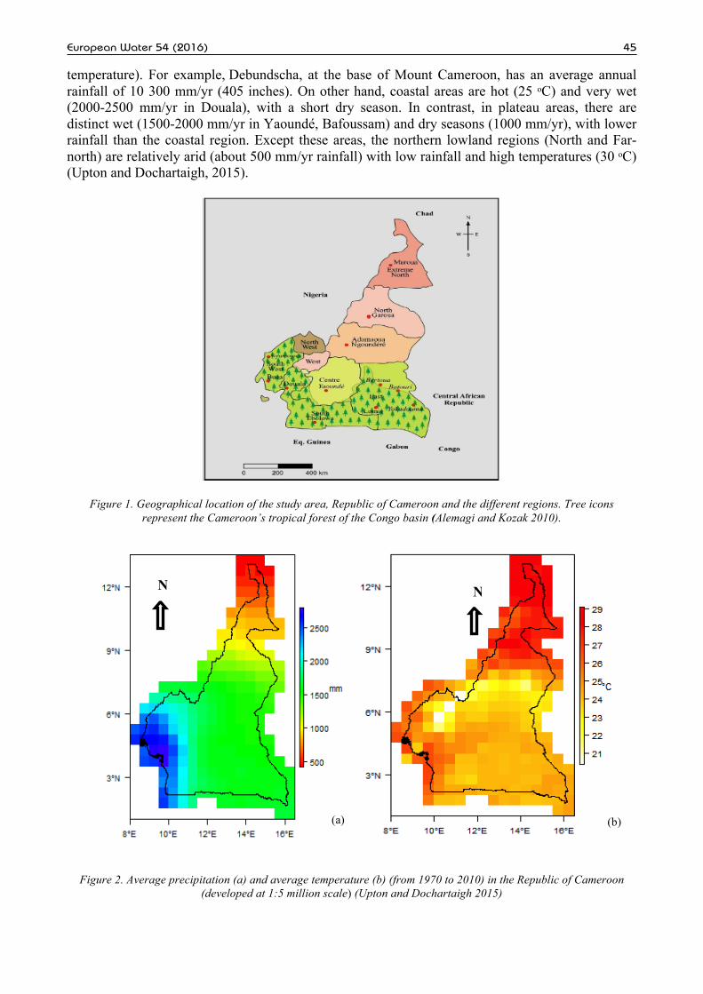
Cameroon is a country located in central Africa which shares a common border with six (6) neighbouring countries, explicitly, Chad, Congo, Equatorial Guinea, Gabon, Nigeria and Republic of Central Africa (Figure 1). Its geographical surface area is 475.442 km2, with abundant natural resources like water bodies, forest, mines etc. Cameroon has a population of 19.4 million inhabitants as per the 2005 census results. Recently, Cameroon population has been estimated to 20,386,799 inhabitants (INS, 2011), with 46.8% of rural population. The fraction of the urban population with access to improved water system is 94.1% instead of 51.9 % for the rural area (INS, 2011). The annual average demographic growth rate is 2.8 % with a Gross Domestic Product (GDP) of 18.3 billion US$ and a GDP per inhabitant of 1.095 US$. It has been proved that the average annual GDP growth rate is 4.5% with an inflation rate of 3% and the legal tender of the country is the CFA Franc, (1euro = 656 FCFA (approx), 1 US$ = 500 FCFA) (GWP-CAFTAC, 2010).
In the Republic of Cameroon, groundwater resources distribution are influenced by natural factors such as climate, soils, land use, land cover characteristics, geomorphology, geology and surface water resources. These factors explain the distribution of precipitations within the country, the runoff (surface water network) and infiltration (groundwater recharge distribution). The following sections provide summarized information on these factors to highlight the status of groundwater quality and quantity in the republic of Cameroon.
2.2 Climate
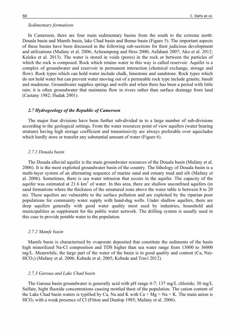
The climate conditions varies with terrain, from tropical along the coast to semiarid and hot at the north. They vary along with topography. On one hand, mild climate with high rainfall is generally found in hilly areas (13 000 mm/yr around the Mount Cameroon, 4100 m of elevation; 20 to 26 ᵒC
European Water 54 (2016) 45
temperature). For example, Debundscha, at the base of Mount Cameroon, has an average annual rainfall of 10 300 mm/yr (405 inches). On other hand, coastal areas are hot (25 ᵒC) and very wet (2000-2500 mm/yr in Douala), with a short dry season. In contrast, in plateau areas, there are distinct wet (1500-2000 mm/yr in Yaoundé, Bafoussam) and dry seasons (1000 mm/yr), with lower rainfall than the coastal region. Except these areas, the northern lowland regions (North and Far-north) are relatively arid (about 500 mm/yr rainfall) with low rainfall and high temperatures (30 ᵒC) (Upton and Dochartaigh, 2015).
Figure 1. Geographical location of the study area, Republic of Cameroon and the different regions. Tree icons represent the Cameroon’s tropical forest of the Congo basin (Alemagi and Kozak 2010).
Figure 2. Average precipitation (a) and average temperature (b) (from 1970 to 2010) in the Republic of Cameroon (developed at 1:5 million scale) (Upton and Dochartaigh 2015)
(a) (b)
N
N

46 C. Defo et al.
The annual rainfall of Cameroon is given in (Figure 2). It is evident from the Table 1 that the total number of rainy days varies from 57 to 74 in different eco-regions of Cameroon while the total amount of rainfall received varied from a low of 691 mm/yr to as high as 13000 mm/yr.
Table 1. Mean total number of rainy days computed from trend lines in the republic of Cameroon
(Molua and Lambi 2007)
1940 1960 1980 1995 2030 2060 Garoua 82.1 79.7 77.2 75.4 71.1 67.4 Ngaoundere 145.9 146.8 147.7 148.4 150.0 151.3 Mamfe 248.4 222.4 196.5 177.0 131.5 92.6 Bamenda 213.5 204.3 195.0 188.0 171.8 157.9 Banyo 138.4 151.6 164.9 174.8 198.0 217.8 Maroua 72.8 71.8 70.8 70.1 68.4 66.9 Douala 142.8 229.6 216.3 206.4 183.3 163.4 Kribi 209.0 205.1 201.1 198.2 191.3 185.4 Yaounde 148.9 149.1 150.5 151.2 152.9 154.3 Ebolowa 156.4 163.8 171.2 176.8 189.7 200.9 Bertoua 123.1 127.4 131.8 135.0 142.6 149.1 Mean 161.9 159.1 156.6 154.7 150.0 146.1
Molua and Lambi (2007) have observed that in such regions of the country (arid climate) total
precipitation can reach maximum value from 800 to 1021 mm/yr. The rainfall is highly erratic and unpredictable which does not follow a definite trend (Table 1). Mean total number of rainy days computed from trend lines in the republic of Cameroon shows a highly variable trend.
2.3 Soils, land use and land cover characteristics and geomorphology
Soils are found in the Republic of Cameroon, from arid climate (North and Far-north) to equatorial forest humid area in the south of the country. Figure 3 shows the major types of soils in Cameroon.
Figure 3. Types of soil in the Republic of Cameroon (developed at 1:5 million scale) (Upton and Dochartaigh 2015)
N

European Water 54 (2016) 47
Table 2 shows the symbols used for the major soil taxonomy in the Republic of Cameroon.
Table 2. Soil classification (Upton and Dochartaigh 2015)
Soil Classification
AC Acrisols AL Alisols AN Andosols AR Arenosols CH Chernozems CL Calcisols CM Cambisols CR Cryosols
DU Durisols FR Ferrasols FL Fluvisols GL Gleysols GY Gypsisols HS Histosols KS Kastanozems LP Leptosols
LX Lixisols LV Luvisols NT Nitisols PH Phaeozems PL Planosols PT Plinthosols PZ Podzols RG Regosols
SC Solonchaks SN Solonetz ST Stagnosols TC Technosols UM Umbrisols VR Vertisols WR Water Body
The land use and land cover conditions of the Republic of Cameroon is a mix stand of forest
vegetation, scrub land and agricultural lands. The central highlands are void of much vegetation while the northern and southern slopes are covered with moderate to good vegetative cover. Cameroon's coastal plain extends from 20 to 80 kilometres inland from the Gulf of Guinea (part of the Atlantic Ocean). The mass of Mount Cameroon reaches almost to the sea. The plain is densely forested including areas of Central African mangroves especially around Douala and in the estuary of the Cross River on the border with Nigeria. The low South Cameroon Plateau, rising from the coastal plain and dominated by tropical rain forest, has an average elevation of 500 to 600 metres. It is less humid than the coast. In western Cameroon is an irregular chain of trees, water bodies that extend from Mount Cameroon almost to Lake Chad at the southern tip of the country.
Terrain of the Republic of Cameroon is largely flat interspersed with a lofty mountain systems aligned along the Cameroon Volcanic Line (CVL) where the highest elevation is found at Mount Cameroon (4100 m). The coastal area is largely plan of lower elevation. The majority of the land is slightly plain to undulating in nature in Northern part while it is moderately to highly undulating in Southern plateau region.
2.4 Surface water resources
The surface water resources of the Republic of Cameroon are well distributed in the entire length and width of the country. The country has four patterns of drainage. In the south, the principal rivers flow south-westward or westward directly to the Gulf of Guinea. The entire country contents different river basins such as: Douala, Sanaga, Sangha, Benue and Lake Chad basins. Figure 4 presents the main rivers available in Cameroon which contribute the principal sources of natural recharge of different aquifers.
2.5 Water use in Cameroon
The hydropower uses the greatest quantity of water in Cameroon (88.74 %) of water use, following by irrigation (7.25 %), then domestic water (2.96 %) (Table 3). Livestock, industries and mines water use is still very low. These sectors especially industries are growing in the country nowadays, according to the political planning of the development of the country (Aka et al. 2004; Adelana et al. 2008; MacDonald et al. 2009, 2012).
However, due to the lack of data, a comprehensible presentation of water use in Cameroon was very limited: The total water-supply quantity was not available, as well as the total water-consume quantity, the amount of groundwater supply which could enable to estimate the proportion of groundwater and surface water supply in the water use assessment.
Geologically the Republic of Cameroon can be divided in four major sub-divisions namely; Basement rocks areas, volcanic formations, crystalline formations and Sedimentary formations. These geological units are being briefly described below.

48 C. Defo et al.
Figure 4. Surface water systems map of Republic of Cameroon (Olivry 1986)
Table 3. Sector wise water use in Cameroon (GWP-CAFTAC 2010)
Water use Lake Chad Niger Sanaga Congo Other coastal rivers Total Cameroon (10-3 km3) %
Domestic 55.07 65.9 101.06 14.09 88.08 326.27 2.96
Livestock 84.01 13.04 / / 97.41 0.88
Irrigation 328.95 377.08 / / 91.79 797.82 7.25
Hydro-power / 7600 2169 / 9769.00 88.74
Industries / 0.33 8.16 0.06 6.62 15.17 0.138
Mines / / / 2.9 2.9 0.026
Total (10-3 km3) 468.03 8056.71 2278.76 17.86 187.21 11008.57 100.00
2.6 Geology of the Republic of Cameroon
2.6.1 Basement rocks areas
In these areas, we distinguish volcanic formations and crystalline formations (Mafany et al. 2006; Akoachere et al. 2013).

European Water 54 (2016) 49
Volcanic formations
The volcanic formations (Figure 5) are generally found in the geographic direction N 30 where the Cameroon Volcanic Line (CVL) is dominated by basaltic rocks with the occasional occurrence of intermediate to acid rocks such as phonolites, trachytes and ryolites on the continental part (Tsafack et al. 2009). The various springs in the formations are typified Fe-Mg-HCO3 or Na-HCO3 composition; HCO3 anion constitutes 90 % of the total area (Ketchemen et al. 2007; Njiekak et al. 2008; Osagie 2010; Luz et al. 2011; Kendall and Doctor 2011; Huneau et al. 2011).
Crystalline formations
In this geological context (Figure 5), there are two types of aquifers: shallow aquifers where the water table in not far from the soil surface. As such, groundwater is stored in the weathering layers of the ground. Such aquifers are exploited by wells for community water supply, with depths generally between 10 to 20 m. These aquifers are vulnerable to the surface pollution. While deep aquifers are stored in fractured rocks; with thickness range between 30 to 80 m, these are exploited with boreholes. The lithology in this case is magmatic, gneissic, quartzitic or schistose and granitic. These aquifers are low mineralised (Mafany et al. 2006; Jayne et al. 2003; Onu 2003).
Figure 5. Geological settings of Republic of Cameroon at 1:5 million scale. (Upton and Dochartaigh 2015)
N
50 C. Defo et al.
Sedimentary formations
In Cameroon, there are four main sedimentary basins from the south to the extreme north: Douala basin and Mamfe basin, lake Chad basin and Benue basin (Figure 5). The important aspects of these basins have been discussed in the following sub-sections for their judicious development and utilizations (Mafany et al. 2006; Acheampong and Hess 2000; Asfahani 2007; Ako et al. 2012; Keleko et al. 2013). The water is stored in voids (pores) in the rock or between the particles of which the rock is composed. Rock which retains water in this way is called reservoir. Aquifer is a complex of groundwater and reservoir in permanent interaction (chemical exchange, storage and flow). Rock types which can hold water include chalk, limestone and sandstone. Rock types which do not hold water but can prevent water moving out of a permeable rock type include granite, basalt and mudstone. Groundwater supplies springs and wells and when there has been a period with little rain; it is often groundwater that maintains flow in rivers rather than surface drainage from land (Castany 1982; Hudak 2001).
2.7 Hydrogeology of the Republic of Cameroon
The major four divisions have been further sub-divided in to a large number of sub-divisions according to the geological settings. From the water resources point of view aquifers (water bearing stratum) having high storage coefficient and transmissivity are always preferable over aquicludes which hardly store or transfer any substantial amount of water (Figure 6).
2.7.1 Douala basin
The Douala alluvial aquifer is the main groundwater resources of the Douala basin (Mafany et al. 2006). It is the most exploited groundwater basin of the country. The lithology of Douala basin is a multi-layer system of an alternating sequence of marine sand and estuary mud and silt (Mafany et al. 2006). Sometimes, there is sea water intrusion that occurs in the aquifer. The capacity of the aquifer was estimated at 21.6 km3 of water. In this area, there are shallow unconfined aquifers (in sand formations where the thickness of the unsatured zone above the water table is between 8 to 20 m). These aquifers are vulnerable to the surface pollution and are exploited by the riparian poor populations for community water supply with hand-dug wells. Under shallow aquifers, there are deep aquifers generally with good water quality most used by industries, household and municipalities as supplement for the public water network. The drilling system is usually used in this case to provide potable water to the population.
2.7.2 Mamfe basin
Mamfe basin is characterised by evaporate deposited that constitute the sediments of the basin high minerilized Na-Cl composition and TDS higher than sea water range from 13000 to 36000 mg/L. Meanwhile, the large part of the water of the basin is in good quality and content (Ca, Na)-HCO3) (Mafany et al. 2006; Kebede et al. 2005; Kebede and Travi 2012).
2.7.3 Garoua and Lake Chad basin
The Garoua basin groundwater is generally acid with pH range 4-7; 137 mg/L chloride; 30 mg/L Sulfate, hight fluoride concentrations causing mottled theet of the population. The cation content of the Lake Chad basin waters is typified by Ca, Na and K with Ca + Mg > Na + K. The main anion is HCO3 with a weak presence of Cl (Fitton and Dunlop 1985; Mafany et al. 2006).

European Water 54 (2016) 51
Figure 6. Hydrogeological map of the Republic of Cameroon at 1:5 million scale (Upton and Dochartaigh 2015)
3. GROUNDWATER RESOURCES IN CAMEROON
Groundwater is the water that has percolated down through surface layers of soil and rocks to join the aquifers until it reaches the impervious layer (a layer of rock / impermeable soil material through which it cannot pass or can pass only very slowly) and eventually rest there until exploited. This results in the accumulation of sizeable amount of water in the rock layers above this impermeable layer depending upon the storage capacity and behaviour of the water bearing aquifers. A small proportion of water resources in training alteration flaws crystalline and volcanic zones. However, it should be noted that there are some poorly known of secondary sedimentary basins. Groundwater resources of Cameroon are evaluated to 55.98 km3, this volume represents 21% of the surface water (Table 4) (MacDonald et al. 2009, 2012; Djoret 2000; Dassi 2011).
Table 4. Estimation of groundwater amount in major saturated watershed in Cameroon (GWP-CAFTAC 2010)
Aquifers Water Volume
(km3) Percentage Volume with
report to the total volume Lac Chad Sedimentary Basin 3.20 5.72 Benue Sedimentary Basin 15.75 28.14 Douala Sedimentary Basin 21.60 38.64 Bedrock areas 15.40 27.51 Total 55.98 100.00
As discussed above, groundwaters in Cameroon are found in two types of geological settings:
i) sedimentary formations and ii) basement rocks area (magmatic and metamorphic rocks) (Figure 5) (Lapworth et al. 2013). Sedimentary formations exist along three major basins: sedimentary
N

52 C. Defo et al.
basin of Lake Chad in the far north, sedimentary basin of the Benue in the North; and the sedimentary basin of the coastal region South – West (IAEA 2006; MeliI et al. 2011; IAEA 2012; Ibrahim et al. 2014). Except these current areas, the basement bedrocks are widespread in other regions of the surface area of the country.
Table 4 shows that sedimentary basins are the most enriched in groundwater resources in Cameroon. Basement rocks (magmatic and metamorphic rocks) cover about 90 % of the national territory and store only 27.51 % of groundwater resources (Mafany et al. 2006; Ngounou and Djoret 2010). Although, water resources are abundant in Cameroon (Ndzeidze 2008; EACC 2010; Chebeu et al. 2011; Yidana and Chegbeleh 2013; Asaah et al. 2014) the study of their variability shows that they are vulnerable to various impacts such as changes climatic and human impacts and pollution (Goni 2006; Oseji et al. 2005; Oga et al. 2008). An advanced management system of water resources should be based on an adequate knowledge of available water resources. This system should also take into account the various uses of those resources and evaluate them.
3.1 Description of groundwater recharge in the Republic of Cameroon
Groundwater recharge studies have been reported by many authors in the semi-arid and humid regions of Africa (Lutz et al. 2011; Mengnjo et al. 2015; Favreau et al. 2009; Fantong et al. 2010; Taylor and Taylor et al. 2013a, b; Wirmvem et al. 2014a). These authors have reported recharge by heaviest and isotopically depleted monsoon rains and recharge by abundant but relatively less depleted rainfall events.
In Cameroon, available data on groundwater recharge are dispersed and scarce. Table 5 presents the description of groundwater recharge published by some investigators in the Republic of Cameroon.
Table 5. Groundwater recharge in different regions of Cameroon
Climate Geology Region Type of recharge Source Authors Average rainfall: 1540 mm/yr, temperature: 26ᵒC
Bedrock area: volcanic
formations
Northwest (Ndop Plain)
Natural recharge 80 % of the recharge is from direct heterogeneous / diffuse local precipitation at low altitude (\1,260 m) 0 % is from high altitude precipitation (localised recharge) or is recharged by the numerous inflowing streams and rivers from high elevations
Mengnjo et al. (2015)
Semi-arid, Average rainfall: 500-800 mm/yr, temperature: 35-45ᵒC
Sedimentary formations
Lac Chad Basin
Natural The regulating reserve gives a figure of 0.1 to 0.5×10⁹ m3 /year, representing an effective infiltration of about 25 to 125 mm/year
Ngounou Ngatcha et al. (2007); Djoret
and Travi (2001)
Average rainfall: 1600 mm/yr, temperature: 24 ᵒC
Bedrock metamorphic area: Gneiss
Anga’a River, Yaoundé
Natural Average recharge value of 87.14 to 236.95 mm/year at the basin scale, which represents 5.7 to 7% of the annual rainfall.
Fouepé et al. (2010)
Semi-arid, Average rainfall: 500-800 mm/yr, temperature: 35-45ᵒC
Pluto-volcanic rocks:
granite/basalt
MayoTsanaga River basin
Natural Monsoon rain recharge of the groundwater at an average rate of 74 mm/year
Fantong et al. (2010)
Semi-arid, Average rainfall: 500-800 mm/yr, temperature: 35-45ᵒC
Pluto-metamorphic basement (quartz monzonite) - Basaltic materials, pyroclastic, surge deposits
Nyos catchment
Natural Approximately 1/3 of the annual precipitation (~3000 mm/yr) infiltrates through the fractures to form shallow aquifers. The recharge is around 940 mm/yr mm/year
Kamtchueng et al. (2016)

European Water 54 (2016) 53
3.2 Hydrodynamic characteristics of some aquifers in Cameroon
Hydraulic properties of the different aquifers such as transmissivity, hydraulic conductivity, storativity were studied in very few case studies in the Republic of Cameroon. Table 6 presents the results obtained in existing articles. Besides this, no information was available on potentiometric network of the different aquifers in Cameroon.
Table 6. Hydrodynamic characteristics of some aquifers in Cameroon
Geology Region Transmissivity T (m2/day)
Hydraulic conductivity K (m/day)
Storativity S
Authors
Metamorphic rocks: gneiss
Upper Anga’a Basin
n.d 3.067-8.27 n.d Fouépé et al. (2012)
Metamorphic rocks: gneiss
Ntem drainage basin, Yaounde
n.d 0.071-2.24
n.d Kalla (2007)
Granitic bedrock Panafrican region of Adamaoua
0.46 to 46.02 0.012 - 1.677 n.d Arétouyap et al. (2015)
Basement rocks (Gneiss)
Yaoundé 0.3 to 50.9 0.01-0.9 n.d Teikeu et al. (2012a, b)
Sedimentary basement
Douala sedimentary basin
120.96 10.19 1.612810-4 GEOFOR (2009)
n.d=not determined
3.3 Groundwater geochemical quality distributed in different basins in Cameroon
Cameroon’s geological history begins with the Archaean era between 3.5 and 2.5 billion years (Ga) ago (Coplen et al. 2000; Benedetti et al. 2003; El Moujabber et al. 2006). Its different phases of development are illustrated by geological masses formed during successive orogenic cycles characterized by the formation of mountain ranges, and subsequent extension phases by the splitting of the continental crust. Cameroon is generally acknowledged to have experienced three orogenic cycles: the Liberian cycle, exemplified by the Ntem complex, which dates from the Archaean era, and is about 2.5 billion years old; the Eburnean or Transamazonian cycle, with the Nyong and Ayna, formations, which date from the Palaeoproterozoic period (2.5-1.8 billion years ago) and the Pan-African cycle, which comprises formations from the Neoproterozoic era 1,000-600 million years (Ma) ago.
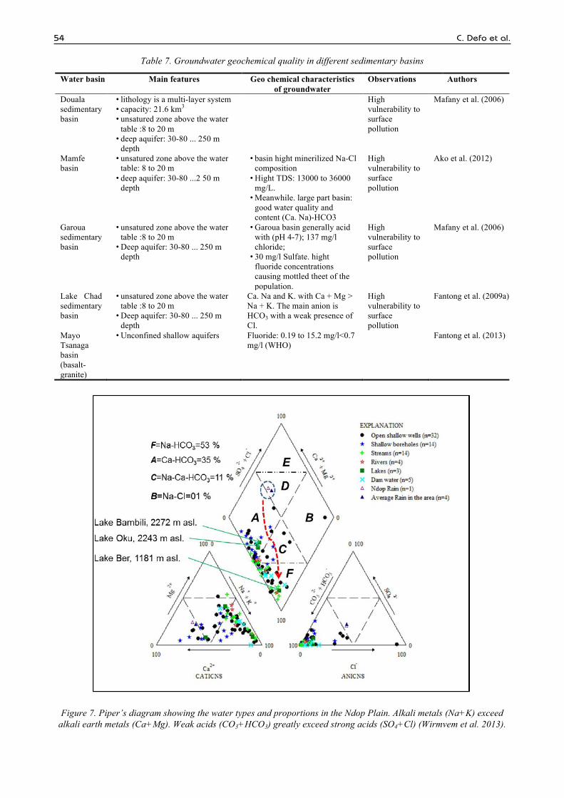
The geochemical quality of groundwater resources is in relation with the geological context and weathering processes of the area. It varies from sedimentary formations to basement rocks while anthropogenic activities contribute to the pollution of the groundwater. The lithology of terrains found over shallow aquifers (thickness) the estimated capacity of groundwater and their geochemical characteristics are shown in Table 7 for sedimentary basins. Existing data for geochemical characteristics of aquifers are dispersed and insufficient, event in papers used in this review to be used on conventional diagrams such as piper to provide a more effective geochemical characterization of aquifers. Nevertheless, an example (Figure 7) of geochemical characterization is shown on Piper diagram. Figure 7 presents the geochemical composition of rain water and its influence on the geochemical characteristics of surface (lake, stream, dam and rivers) and groundwater (wells, boreholes) of the Ndop plain in the North-west Cameroon.
As reported by Wirmvem et al. (2013), the dash line in the diamond section indicates the path of chemical evolution from Ca-Mg-SO4-Cl (rain), to Ca-HCO3 (groundwater, lakes and dam water), and to Na-HCO3 (groundwater, streams and rivers). Ca-Na-HCO3 represents a transition (mixing zone) from Ca-HCO3 to Na-HCO3 water.
Equally, Table 8 presented the lithology of terrains found over shallow aquifers (thickness) and basement rocks forming reservoirs and their geochemical characteristics.
54 C. Defo et al.
Table 7. Groundwater geochemical quality in different sedimentary basins
Water basin Main features Geo chemical characteristics of groundwater
Observations Authors
Douala sedimentary basin
• lithology is a multi-layer system • capacity: 21.6 km3 • unsatured zone above the water
table :8 to 20 m • deep aquifer: 30-80 ... 250 m
depth
High vulnerability to surface pollution
Mafany et al. (2006)
Mamfe basin
• unsatured zone above the water table: 8 to 20 m
• deep aquifer: 30-80 ...2 50 m depth
• basin hight minerilized Na-Cl composition
• Hight TDS: 13000 to 36000 mg/L.
• Meanwhile. large part basin: good water quality and content (Ca. Na)-HCO3
High vulnerability to surface pollution
Ako et al. (2012)
Garoua sedimentary basin
• unsatured zone above the water table :8 to 20 m
• Deep aquifer: 30-80 ... 250 m depth
• Garoua basin generally acid with (pH 4-7); 137 mg/l chloride;
• 30 mg/l Sulfate. hight fluoride concentrations causing mottled theet of the population.
High vulnerability to surface pollution
Mafany et al. (2006)
Lake Chad sedimentary basin
• unsatured zone above the water table :8 to 20 m
• Deep aquifer: 30-80 ... 250 m depth
Ca. Na and K. with Ca + Mg > Na + K. The main anion is HCO3 with a weak presence of Cl.
High vulnerability to surface pollution
Fantong et al. (2009a)
Mayo Tsanaga basin (basalt-granite)
• Unconfined shallow aquifers Fluoride: 0.19 to 15.2 mg/l<0.7 mg/l (WHO)
Fantong et al. (2013)
Figure 7. Piper’s diagram showing the water types and proportions in the Ndop Plain. Alkali metals (Na+K) exceed alkali earth metals (Ca+Mg). Weak acids (CO3+HCO3) greatly exceed strong acids (SO4+Cl) (Wirmvem et al. 2013).
European Water 54 (2016) 55
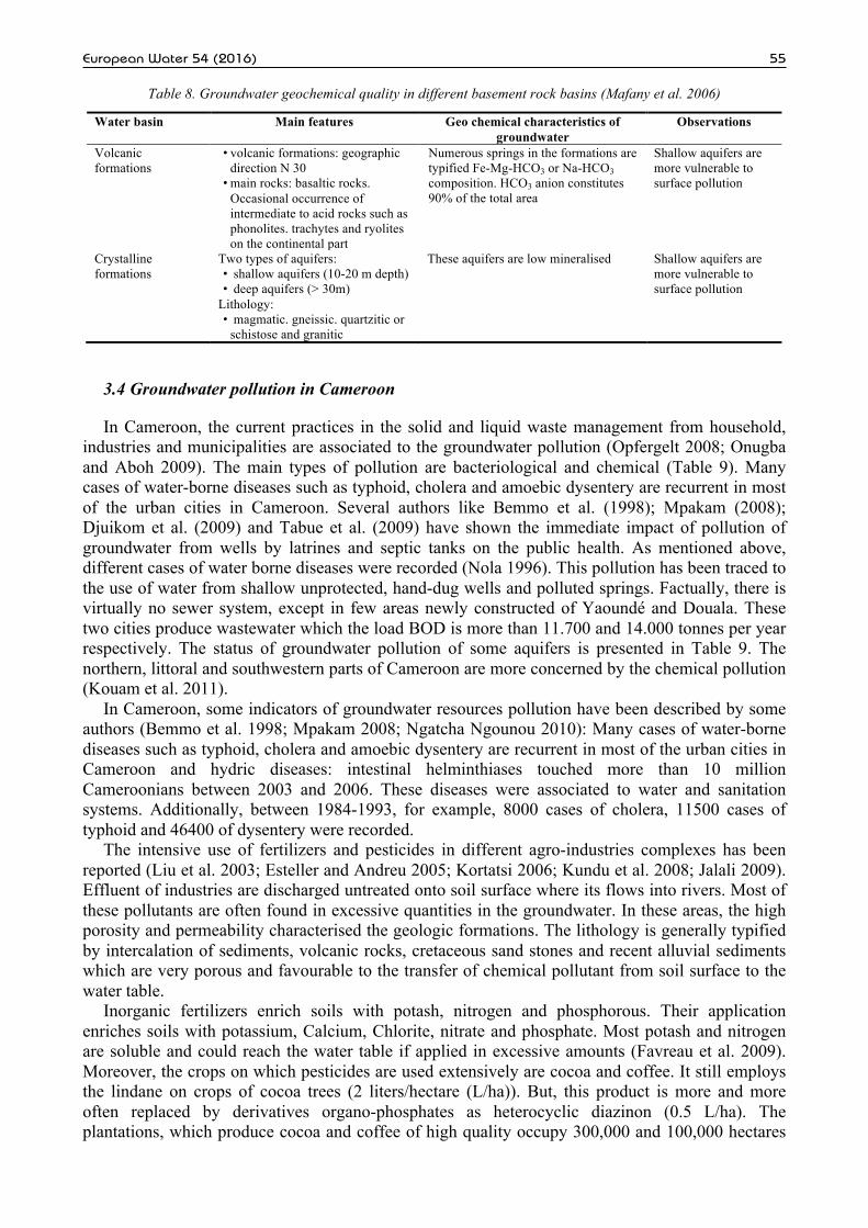
Table 8. Groundwater geochemical quality in different basement rock basins (Mafany et al. 2006)
Water basin Main features Geo chemical characteristics of groundwater
Observations
Volcanic formations
• volcanic formations: geographic direction N 30
• main rocks: basaltic rocks. Occasional occurrence of intermediate to acid rocks such as phonolites. trachytes and ryolites on the continental part
Numerous springs in the formations are typified Fe-Mg-HCO3 or Na-HCO3 composition. HCO3 anion constitutes 90% of the total area
Shallow aquifers are more vulnerable to surface pollution
Crystalline formations
Two types of aquifers: • shallow aquifers (10-20 m depth) • deep aquifers (> 30m)
Lithology: • magmatic. gneissic. quartzitic or
schistose and granitic
These aquifers are low mineralised Shallow aquifers are more vulnerable to surface pollution
3.4 Groundwater pollution in Cameroon
In Cameroon, the current practices in the solid and liquid waste management from household, industries and municipalities are associated to the groundwater pollution (Opfergelt 2008; Onugba and Aboh 2009). The main types of pollution are bacteriological and chemical (Table 9). Many cases of water-borne diseases such as typhoid, cholera and amoebic dysentery are recurrent in most of the urban cities in Cameroon. Several authors like Bemmo et al. (1998); Mpakam (2008); Djuikom et al. (2009) and Tabue et al. (2009) have shown the immediate impact of pollution of groundwater from wells by latrines and septic tanks on the public health. As mentioned above, different cases of water borne diseases were recorded (Nola 1996). This pollution has been traced to the use of water from shallow unprotected, hand-dug wells and polluted springs. Factually, there is virtually no sewer system, except in few areas newly constructed of Yaoundé and Douala. These two cities produce wastewater which the load BOD is more than 11.700 and 14.000 tonnes per year respectively. The status of groundwater pollution of some aquifers is presented in Table 9. The northern, littoral and southwestern parts of Cameroon are more concerned by the chemical pollution (Kouam et al. 2011).
In Cameroon, some indicators of groundwater resources pollution have been described by some authors (Bemmo et al. 1998; Mpakam 2008; Ngatcha Ngounou 2010): Many cases of water-borne diseases such as typhoid, cholera and amoebic dysentery are recurrent in most of the urban cities in Cameroon and hydric diseases: intestinal helminthiases touched more than 10 million Cameroonians between 2003 and 2006. These diseases were associated to water and sanitation systems. Additionally, between 1984-1993, for example, 8000 cases of cholera, 11500 cases of typhoid and 46400 of dysentery were recorded.
The intensive use of fertilizers and pesticides in different agro-industries complexes has been reported (Liu et al. 2003; Esteller and Andreu 2005; Kortatsi 2006; Kundu et al. 2008; Jalali 2009). Effluent of industries are discharged untreated onto soil surface where its flows into rivers. Most of these pollutants are often found in excessive quantities in the groundwater. In these areas, the high porosity and permeability characterised the geologic formations. The lithology is generally typified by intercalation of sediments, volcanic rocks, cretaceous sand stones and recent alluvial sediments which are very porous and favourable to the transfer of chemical pollutant from soil surface to the water table.
Inorganic fertilizers enrich soils with potash, nitrogen and phosphorous. Their application enriches soils with potassium, Calcium, Chlorite, nitrate and phosphate. Most potash and nitrogen are soluble and could reach the water table if applied in excessive amounts (Favreau et al. 2009). Moreover, the crops on which pesticides are used extensively are cocoa and coffee. It still employs the lindane on crops of cocoa trees (2 liters/hectare (L/ha)). But, this product is more and more often replaced by derivatives organo-phosphates as heterocyclic diazinon (0.5 L/ha). The plantations, which produce cocoa and coffee of high quality occupy 300,000 and 100,000 hectares

56 C. Defo et al.
respectively and the total quantity of pesticides used is approximately 100.0 (L/ha).
Table 9. Groundwater pollution in some regions of Cameroon
Aquifer Geology Region Type of pollutant/Range Source Authors Shallow
Deep Volcanic
formations Southwest
(Ekondo Titi) (CVL)
As (III): 0.2 mg/l 2mg/l
NO3: 2.9- 17.28 <50 mg/l (WHO)
Agriculture (Pamol plantation).
Lobe Sediments N-fertilizers (Banana Plantation). animal
waste.
Mbotake (2006) Ako et al. (2012)
Shallow Basaltic rocks NorthWest (Ndop)
TC: 1.100 CFU/100ml pH: 5.89;
Cattle grazing. pit latrines
Mengnjo et al. (2013)
Shallow Sedimentary formations
Benue basin-North (Garoua)
TC: 8.19*E9 CFU/100ml FC: 3’8 E3 CFU/100ml
E.Coli: 5.8E1 CFU/100ml FS: 3.8E1 CFU/100ml
Pit latrines. open rubbish dumps. open
drains
Moussa et al. (2013)
Well Sedimentary formations
Douala basin-Littoral
Heterotrphic bacteria: 2.5 E3 CFU/100ml;
TC: 1.4E3-44E3 CFU/100ml FC: 6.03E3-29E5
CFU/100ml
High population density; pit latrines. sceptic tanks. poor
drainage system
Akoachere et al. (2013) Djuikom et al. (2009)
Shallow Gneiss Centre (Yaoundé)
Pb: 0.33 Cd: 0.08 Cr:1.31 Ni:0.61 in mg/l CF: 270-37E4 CFU/100ml; FC: 5 -35 E2 CFU/100ml; FS: 5-9.6E3 CFU/100ml
NH4 : 11.02 mg/l> 0.5 ppm (WHO)
Auto exhaust. runoff. wastes dumpsites. urban agriculture. Pit latrines. open
drains. sceptic tanks
Defo et al. (2015) Bemmo et al. (1998). Nganti (2012). Kouam Kemogne et al. (2011)
Well Basaltic rocks West (Bafoussam)
NO3: 220.9 mg/l; NH4: 0.7mg/l
FC: 30-5000 CFU/100ml TC: 10 000 CFU/100ml
Poor saniation system. agriculture
Mpakam (2008)
In Cameroon, due to the weakness of institutions and inadequate laws, many agro-industrial
plantations which are all over the country apply extensive fertilizers and discharge their waste untreated in the nature. These observations are consistent for industries, hospitals and domestic wastes. Consequently, chemicals are found in the groundwater (Kuitcha et al. 2008; Kauman et al. 2011; Defo et al. 2015). Artisan mining of the gold in the southeastern and eastern Cameroun might be releasing substantial quantities of arsenic in the groundwater (Mafany et al. 2006; Brand et al. 2009). Common artisan techniques usually use submersible pumps to intercept water table of shallow aquifers, so to get access to the gold-bearing lithology. Pumping and dewatering hydrothermal altered granitic aquifers enriches (FeAsS) and (FeS2) introduce oxygen in groundwater provokes oxidation of arsenic sulphides to release arsenic (Mafany et al. 2006).
3.5 Groundwater exploitation in Cameroon
3.5.1 Borehole and well construction
Castany (1982), Singhal and Gupta (2010), MacDonald and Davis (2000) and Geobase (2009) indicated the steps involved in the construction of wells and boreholes. These are well known conventional methods used worldwide for wells and boreholes construction. Figure 8a and b shows some practical applications of these methods in the field work in Cameroon. Besides this, many indigenous hand-dug wells are distinguished and are not constructed according to modern standards to provide good quality water. These types of wells are low cost and are used generally by poor population with no access to public water network. Therefore, these populations are exposed to water borne diseases.

European Water 54 (2016) 57
3.5.2 Groundwater prospection
In practice, locations of boreholes and wells are setting by taking in account of the proximity of potential sources of contamination. The most common sources of pollution are septic tanks, silage pits, oil tanks, manure, and dirty water draining from farmyards (Tabue et al. 2009; Nguendo 2010; UNICEF/WHO 2010; Nganti 2012; Mouna et al. 2013). The hydro geological and geophysical methods are generally used by engineers for the groundwater exploration (Figure 8 a, b). These methods are conventional and well known worldwide. Besides, there’s an informal prospecting method of using chopsticks in copper (Geobase 2009). Nevertheless, in Cameroon, many groundwater supply projects have not been successfully achieved during the drilling, yield test and water quality analysis steps due to the failure of contractors to apply the groundwater exploration conventional methods. For some cases, it was due to the lack of qualified manpower in the company, and/or the lack of equipments. In Cameroon, in some cases due to non application of standard methods, the wells developed in aquicludes or aquitards become non functional, leaving the out casing as potential danger to surrounding populations and animals.
Figure 8. Groundwater exploration: Geo-electrical soundings (Shlumberger quadrupole) (Geobase 2009)
3.5.3 Main features of a borehole for community water supply in Cameroon
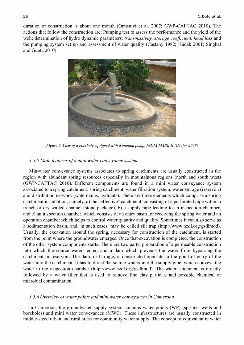
In recent years, groundwater has been increasingly utilized for water supplies, especially rural hydraulic in Cameroon where it is often relatively easy to access and requires less rigorous treatment than surface water (Geobase 2006; Geofor 2008; Geobase 2009). The main source works for water supply in rural areas of Cameroon are boreholes and wells, generally equipped with manual pumps (Figure 9). Sometimes, electric pumps are used to drive water into the water supply system (Deshpande et al. 2003; Demlie et al. 2007).
Generally for community water supply, the realization of a borehole follows all the steps quoted above. The characteristics of a borehole are as follows: Diameter 125 - 250 mm (Figure 9); depth 30 – 250 m; techniques of construction: drilling using rotary method (in sedimentary zones or weathered layers in bedrocks zones) and air-hammer in bedrocks. Duration of construction: 1 week.
3.5.4 Main features of a well for community water supply in Cameroon
Wells are generally characterised by a diameter (0.8 – 1.2 m), a depth (10 – 20 m), and hand-dug. The equipment of the water wells is made by cuvelage or pre-made tubes (concretes). The
a b
58 C. Defo et al.
duration of construction is about one month (Omosuyi et al. 2007; GWP-CAFTAC 2010). The actions that follow the construction are: Pumping test to assess the performance and the yield of the well; determination of hydro dynamic parameters: transmissivity, storage coefficient, head loss and the pumping system set up and assessment of water quality (Castany 1982; Hudak 2001; Singhal and Gupta 2010).
Figure 9. View of a borehole equipped with a manual pump, INDIA MARK II (Geofor 2008)
3.5.5 Main features of a mini water conveyance system
Min-water conveyance systems associates to spring catchments are usually constructed in the region with abundant spring resources especially in mountainous regions (north and south west) (GWP-CAFTAC 2010). Different components are found in a mini water conveyance system associated to a spring catchment: spring catchment, water filtration system, water storage (reservoir) and distribution network (watermains, hydrants). There are three elements which comprise a spring catchment installation; namely, a) the "effective" catchment, consisting of a perforated pipe within a trench or dry walled channel (stone package), b) a supply pipe leading to an inspection chamber, and c) an inspection chamber, which consists of an entry basin for receiving the spring water and an operation chamber which helps to control water quantity and quality. Sometimes it can also serve as a sedimentation basin, and, in such cases, may be called silt trap (http://www.nzdl.org/gsdlmod). Usually, the excavation around the spring, necessary for construction of the catchment, is started from the point where the groundwater emerges. Once that excavation is completed, the construction of the other system components starts. There are two parts; preparation of a permeable construction into which the source waters enter, and a dam which prevents the water from bypassing the catchment or reservoir. The dam, or barrage, is constructed opposite to the point of entry of the water into the catchment. It has to direct the source waters into the supply pipe, which conveys the water to the inspection chamber (http://www.nzdl.org/gsdlmod). The water catchment is directly followed by a water filter that is used to remove fine clay particles and possible chemical or microbial contamination.
3.5.6 Overview of water points and mini water conveyances in Cameroon
In Cameroon, the groundwater supply system contains water points (WP) (springs. wells and boreholes) and mini water conveyances (MWC). These infrastructures are usually constructed in middle-sized urban and rural areas for community water supply. The concept of equivalent in water

European Water 54 (2016) 59
point (EWP) is generally retained for quantification of the existing infrastructures (every work of mobilization in drinking water designed to provide the population following the standards adopted in Cameroon: namely 250 to approximately 300 people with a daily subsidy fixed to 25 litres per capita the work that must supply a day approximately 7.5 - 8 m3 of the water during 12 hours a day). From the concept of equivalent water source the realizations in rustic hydraulics (Table 10) are estimated.
Table 10. State of the realizations of rural hydraulics in Cameroon (GWP CAFTAC 2010)
Regions
Boreholes Wells
Improved springs
MWC
Total WP
EWP 2001-2007
EWP
Adamaoua 313 237 0 26 576 200 1 010 Centre 648 455 693 81 1 877 800 3 406 East 245 170 94 38 547 200 1 089 Extrem- North
2328 649 0 2 2 979 400 3 397
Littoral 139 32 85 48 304 150 886 Nord 1382 1219 4 2 2 607 300 2 925 North-West 35 18 88 93 234 400 1 471 West 99 36 107 63 305 350 1 222 South 90 218 142 33 483 300 1 080 South-West 27 14 68 75 184 400 1 259 Total 5306 3048 1 281 461 10 096 3 500 17 745
Around the country, the rural hydraulic programmes are facing many difficulties of management.
These facts concern especially the management committees of water sources who have difficulty in recovering from the users in spite of various modes of covering necessary for the exploitation, the maintenance and the renewal of the water systems. This managerial ineffectiveness proved raises in addition to the problem of the application of the choice of this option of management of water sources.
4. INSTITUTIONS IN CHARGE AND POLICY FRAMEWORK FOR EFFICIENT AND POTENTIAL UTILIZATION OF WATER RESOURCES IN THE REPUBLIC OF CAMEROON
4.1 Institution reforms
Several institutions are involved in water management. The institutions can be categorised into private, public and NGOs. The main actor is the Ministry of Mines, Energy and Water which has responsibility for water supply and sanitation in both rural areas and towns through the Directorate of Directorate of Water (AMCOW 2011). In recent years, the former National Water Supply Company of Cameroon (SNEC: Société Nationale des Eaux du Cameroun) has been privatised with the creation of the Cameroon Water Utilities Corporation (CAMWATER) with responsibility for public water supplies in urban areas; and the responsibility for the construction and management of rural wells and boreholes has been transferred to communes (AMCOW 2011). In addition, three hundred thirty six (336) national councils (communes) are involved in the work of water management (Decree No. 2010/0239/PM transferred the competencies for the construction and management of wells and boreholes to communes (the drinking water networks remain with the state) (AMCOW 2011). Besides this, NGOs and Privates, and several Engineering Consulting Offices, and other international actors are working along with the government for water management in Cameroon.
4.2 Legal framework
Water is considered to be public property in Cameroon, managed by the government.
60 C. Defo et al.
Arrangements have been made to designate one or more government agencies with ultimate responsibility over water resources, including allocation supervision of water rights and the preparation of plans. Recently many programs and policies, as well as enforcement provisions were made to streamline the conservation, development, exploitation and proper management. Prior to this, legal texts were only concerned with the protection of resources. Under the 1998 Water Law (law No. 98/005 of the 14th April 1998) pertaining to water regulations is supplemented by implementing provisions as of 2001, which also pertain to the management of the service. The Law No. 2004/18 setting out the rules applicable to communes. Also; the decree No. 2005/493 was made setting out the means of delegation of WSS public services in urban and peri-urban areas. Further; the decree No. 2010/0239/PM was promulgated transferring the competencies for the construction and management of wells and boreholes to communes (the drinking water networks remain with the state).
4.3 International Water Resources Management (IWRM) and sustainable development goals (SDGs)
According to the GWP (2015), water crises is ranked the highest among the top ten global risks in terms of impact and eighth in terms of likelihood. The impact of climate change will only exacerbate water crises. Many people lack access to water resources for drinking water supply and many regions are faced with economic water scarcity. The scale of today’s water security challenge should not be underestimated. Threats to water security come from many different areas: rapidly growing and urbanizing populations with changing lifestyles and consumption patterns; competing demands from agriculture, industry, and energy; unpredictable risks caused by climate change and environmental degradation; and growing tension over scarce water resources that flow across administrative boundaries.
In the Millennium Development Goals (MDGs), water security for direct human needs gained prominence. In the development of the SDGs there is an additional focus on the sustainable management of water for economic growth and on water risks. Placing the water dedicated goal in the SDG broader context will foster attention to water resources management practices more prominently.
IWRM provides a framework within which to consider trade-offs between different development objectives and, where possible, to identify win-win water investments. Water related investments can increase economic productivity and growth. This relation is bi-directional; the resulting economic growth can provide the resources to finance capital-intensive investments in water related infrastructure. In other words, while economic growth can enhance risks (such as water pollution) it also provides the critical resources needed to manage water related risks (flood protection measures).
By aligning and integrating interests and activities that are traditionally seen as unrelated or that, despite obvious interrelationships, are simply not coordinated, IWRM can foster more efficient and sustainable use of water resources to achieve the SDGs. The SDGs alone cannot establish a policy guideline. However, IWRM might help to establish policies on local, national and even international level. IWRM is not simply a process designed to carry us to a set of SDGs targets but a way of thinking that enhances our capacity to tackle multi-objective, multi-sectoral development planning such as is embodied by the SDGs. IWRM is a structured process that addresses the need to bring together those who use water and those who have a great impact on the governance of water to work together to solve water challenges.
Many countries have developed IWRM and water efficiency plans following the target set in Johannesburg 2002. However, few plans have been implemented and that now has to be a priority. In Cameroon, IWRM plan is therefore a part of national development strategies.

European Water 54 (2016) 61
4.4 IWRM Planning in Cameroon
Abundant freshwater resources characterize Cameroon, yet the country faces severe water challenges as a result of management, legal and institutional deficiencies. Due to the fragmented water sector, development in Cameroon goes slowly. To increase the sustainability of water resources management, Cameroon has embarked on a process towards developing integrated water resources management plans.
The process started with the setting up of the Global Water Partnership (GWP) Cameroon in June 2005, designed to facilitate the planning process by creating a neutral platform for all water sector stakeholders in Cameroon.
Cameroon has completed the first two phases of the country’s IWRM planning process and is currently preparing the national IWRM action plan, which is the third phase. IWRM planning is regarded as an important strategy by Cameroon to reduce poverty and to achieve the Millennium Development Goals. During the implementation of the program, much emphasis was given to capitalizing and aligning with existing and ongoing initiatives. The Global Water Partenership (GWP) Cameroon further ensured that water sector stakeholders were trained on the concept of IWRM. Special attention was given to the participation of women and youths.
A Cameroon Horizon 2035 long-term development vision was developed in March 2009 with a ten-year economic growth framework or Growth and Employment Strategy Paper (GESP) which was designed to be implemented from 2010 to 2019 (Ako et al. 2010; Massanga 2014). Today in Cameroon, some of the main objectives of the government are also to ensure environmental sustainability. There are dire needs that the public accesses to potable water should be increased from 50 percent to 75 percent; which further will depend upon the availability and quality of the ground water requiring immediate attention of all. This requires huge investments in order to curb existing quality deficiencies and improve storage and treatment capacities. Therefore, very high priority should be given to the realisation of water supply networks which will go along with the construction of wells and boreholes. Progress in water and sanitation is show in Figure 10.
Figure 10. Progress in water supply and sanitation in Cameroon (UNICEF/WHO Joint Monitoring Programme, JMP 2010)
5. MAIN CONSTRAINTS OBSERVED IN GROUNDWATER MANAGEMENT IN CAMEROON
The major difficulty in Cameroon is not the availability of water however; there are many other problems of different kinds which are identified in groundwater development projects in Cameroon. The most remarkable and daunting problems as discussed by UNICEF/WHO Joint Monitoring Programme (JMP) (2010) are explicitly: Poor management and development of the resources coupled with inadequate political will and commitment for the long term (Figure 11), the patchiness and of available information on the quality and quantity of water resources is a major constraint for
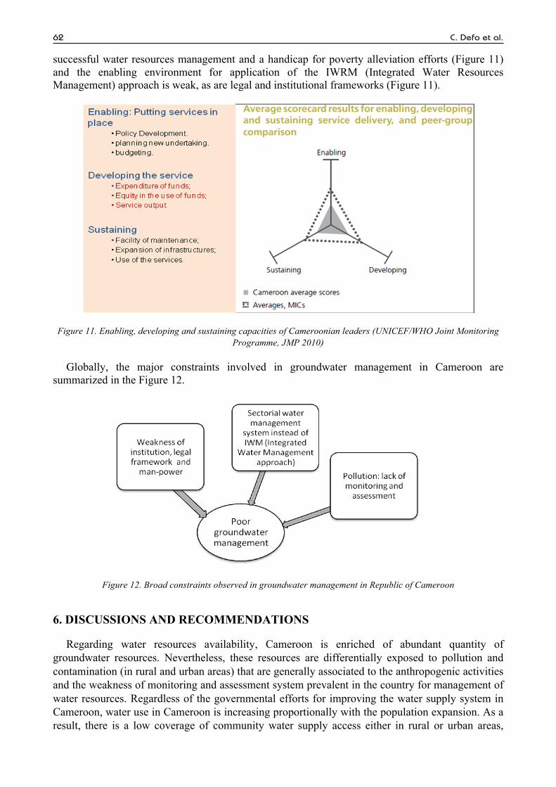
62 C. Defo et al.
successful water resources management and a handicap for poverty alleviation efforts (Figure 11) and the enabling environment for application of the IWRM (Integrated Water Resources Management) approach is weak, as are legal and institutional frameworks (Figure 11).
Figure 11. Enabling, developing and sustaining capacities of Cameroonian leaders (UNICEF/WHO Joint Monitoring Programme, JMP 2010)
Globally, the major constraints involved in groundwater management in Cameroon are summarized in the Figure 12.
Figure 12. Broad constraints observed in groundwater management in Republic of Cameroon
6. DISCUSSIONS AND RECOMMENDATIONS
Regarding water resources availability, Cameroon is enriched of abundant quantity of groundwater resources. Nevertheless, these resources are differentially exposed to pollution and contamination (in rural and urban areas) that are generally associated to the anthropogenic activities and the weakness of monitoring and assessment system prevalent in the country for management of water resources. Regardless of the governmental efforts for improving the water supply system in Cameroon, water use in Cameroon is increasing proportionally with the population expansion. As a result, there is a low coverage of community water supply access either in rural or urban areas,

European Water 54 (2016) 63
many of whom are amongst the poorest and most vulnerable population. This study showed that groundwater plays an important role in meeting the water needs, particularly the domestic water needs of the rural and urban people. However, there is only little information on the extent of use of the groundwater in different sectors (industries, domestics, agriculture, and livestock watering). These observations are consistent with those recorded by many authors reviewing groundwater management in Africa. As reported in many other researches in numerous places in the Africa, the management of groundwater remains a challenge in term of its protection, its availability and its pollution (UN/WWAP 2003; Xu and Ushe 2006; Nwankwoala 2014; Pavelic et al. 2012; Lapworth et al. 2013). Besides this, some aspects groundwater research incompleteness are specific to the Republic of Cameroon. Many groundwater researches and reports have been done in different locations in Cameroon, with most of them focussing on the hydrogeology and well drillings, hand-dug wells and groundwater quality. However, these studies were not coordinated leaving limited and dispersed data for groundwater resources in Cameroon. Therefore, this review invites researchers and decision makers to take urgent actions needed to bridge the gaps by way of additional research.
Based on the analysis and our understanding of the system we recommend the following six point strategies for implementation by the government, for enhancing the availability and parity in water used by the rich and poor alike, and for efficient groundwater management in Cameroon:
i) A comprehensive groundwater inventory in Cameroon is needed. A proper hydrodymic, geochemical and pollution status of aquifers in different basins should be researched and understood. This will help to sufficiently address various important issues including the extent of groundwater use by the various sectors (domestic, agriculture-irrigation and livestock, and industry), the spatial and social patterns in groundwater use, the background of households using the resource, and comparative cost analysis of using groundwater and surface water for community water supply, irrigation and livestock watering.
ii) Modelling should be effectively applied in groundwater research in Cameroon: As a powerful tool which enable to minimize the cost of chemicals, labours, lab work and which help to predict the behaviour of aquifers over extended period of time, researchers should introduce these tools intensively in groundwater research in Cameroon to produce data necessary to decision makers to plan actions for efficient groundwater resources management.
iii) The government of Cameroon should initiate a country wide program of educating the masses, empowering the institutions, local population to take care of water resources by cleaning polluted rivers and protecting unpolluted ones (to mitigate groundwater contamination) around the country, maintaining water infrastructures (boreholes, wells, mini water conveyances and sanitation systems), and apply the law related to environmental protection to restricting the production of wastes and pollutants, avoid improper waste dumpsites.
iv) Application and monitoring of integrated water management approach in different basins: Combining public (government and communes) and private actors, inter sector activities concerning (water supply, sanitation, industries and agriculture), all actors of different rivers basing management to coordinating actions for efficient groundwater management around the country.
v) Wastewater recycling (at low cost through constructed wetlands technology) as strategy to mitigating environmental pollution should be encouraged in industries, municipalities and in agriculture.
vi) Improve the groundwater governance through enabling actions (putting services in place such as policy improvement, planning new actions and budgeting), developing services (expenditure of funds, equity in funds use), and sustaining (Facility of maintenance, expansion of infrastructures).

64 C. Defo et al.
8. CONCLUSIONS
The aim of the present review was to investigate the availability of groundwater resources in the Republic of Cameroon, its exploitation and its pollution status. Besides this the policy framework and institutional reforms were analyse to comprehend the strength and weaknesses of the groundwater management in Cameroon. It appeared from the analysis that the main problem of groundwater resources management is no from its availability, but from its management. Therefore, the following constraints were observed in the groundwater management system: Very limited and dispersed datasets are available for different aquifers in different regions. These datasets are related to the global water use, the proportion of groundwater and surface water supply, the distribution of groundwater hydro geochemical, hydrodynamic, hydraulic, recharge and pollution characteristics related to different drainage basins and geological conditions. Besides this, the weaknesses of institutions in charge and management practices, and legal framework were observed leading to a poor management of groundwater resources characterized by its pollution in different basins. In the light of the above analysis; following main conclusions have been drawn which need immediate attention of the water resources managers; planners and policy makers for immediate attention for efficient and potential utilization for the available water resources for the welfare of one and all: (i) the government is required to pay little more attention for the protection of these resources trough the reinforcement of water laws and institutions in charge; (ii) complete inventory of the status of water pollution and devising new strategies to update and mitigate its effects; (iii) increase the financial potential of the water and sanitation sectors for the implementation of water supply system and sanitation for the reduction of poverty; (iv) accelerate the transfer of contracting to the municipalities; and (v) increase staff strength in the ministries in charge of water resources.
ACKNOWLEDGEMENTS
Authors wish to extent their heartfelt thanks to a large number of people who have directly and indirectly helped in successful completion of this work. The first author is particularly indebted to the African Union and the Government of India for sponsorship (through India-Africa Fellowship Program) to study at IARI New Delhi India towards his doctoral degree in Water Science and Technology (WST) and the meaningful collaboration with the scientists at the centre particularly Dr. (Ms) Ravinder Kaur, Chairperson of his Ph. D advisory committee, Project Director Water Technology Centre and Director of the Indian Agricultural Research Institute (IARI); Dr. A. K. Mishra, Dr. Man Singh, Professor of the Faculty of Water Science and Technology, IARI; Dr. Mannoj Khana, the seminar leader (WST, 2014); Dr. Khajanchi Lal, Co-Chairman of his advisory committee and all the Scientists of WST and IARI. Equally, the first is thankful to Pr. Yerima Bernard Palmer Kfuban of the Faculty of Agronomy and Agricultural Science; university of Dschang, Cameroon; Dr. Paul Blaise Mabou, University of Yaoundé 1, Cameroon and Prof Ako A. Andrew (IRGM, Yaoundé) for their collaboration.
REFERENCES
Acheampong, S. Y., Hess, J. W., 2000. Origin of the shallow groundwater system in the southern Voltaian sedimentary basin of Ghana: an isotopic approach. J Hydrol 233 : 37–53.
Adelana, S. A. M., MacDonald, A. M., 2008. Groundwater research issues in Africa. In: Adelana, S. A. M., MacDonald AM (ed) Applied groundwater studies in Africa. Taylor and Francis, London, pp 1–8.
Aka, F. T., Nagao, K., Kusakabe, M., Sumino, H., Tanyileke, G., Ateba, B., Hell, J., 2004. Symmetrical helium isotope distribution on the Cameroon Volcanic Line, West Africa. Chem Geo 203 (3–4):205–223.
Ako A. A., Eneke, T. E. G., Elambo, Nkeng, G., 2010. Water Resources Management and Integrated Water Resources Management (IWRM) in Cameroon, Water Resour Manage, 24:871–888.
Ako, A. A., Jun S, Takahiro, H., Kimpei, I., Nkeng, G. E., Fantong, W. Y., Eyong, G. E. T., Ntankouo, N. R., 2011. Evaluation of groundwater quality and its suitability for drinking, domestic, and agricultural uses in the Banana Plain (Mbanga, Njombe, Penja) of the Cameroon Volcanic. Environ Geochem Health 33:559–575.
European Water 54 (2016) 65
Ako, A. A., Jun, S., Takahiro, H., Makoto, K.., Akoachere, R. A., George, E. N., Gloria, E. T. E., Alain, L. F. T., 2012. Spring water quality and usability in the Mount Cameroon area revealed by hydrogeochemistry. Environ Geochem Health 34:615–639.
Ako, A. A., Shimada, J., Hosono, T., Ichiyanagi, K., Nkeng, G. E., Eyong, G. E. T., Ntankouo, N. R., 2012. Hydrogeochemical and isotopic characteristics of groundwater in Mbanga, Njombe and Penja (Banana plain)-Cameroon. J Afr Earth Sci 75: 25–36.
Akoachere, J. F. T. K., Lundi-Anne, O., Massalla, T. N., 2013. Assessment of the relationship between bacteriological quality of dug-wells, hygiene behaviour and well characteristics in two cholera endemic localities in Douala, Cameroon. Hindawi Publishing Corporation International Journal of Bacteriology. doi: 10.1155/2013/127179
Alemagi, D. and Kozak, R. A. 2010. Illegal logging in Cameroon: Causes and path forwards. Forest Policy and Economy. 12, 554-561.
ANOR, 2001. Cameroon mineral water quality norms (NC 05: 2001-02) Agence Nationale des Normes et Qualité, Yaoundé. ANOR, 2003. Cameroon drinking water quality norms (NC 207: 2003-02). Agence Nationale des Normes et Qualité, Yaoundé. Arétouyap, Z., Nouck, N. P., Nouayou R, Méli’i, J. L., Kemgang Ghomsi, F. E., Piepi Toko, A. D., Asfahani, J., 2015. Influence of
the Variogram Model on an Interpolative Survey Using Kriging Technique. J Earth Sci Clim Change. 6: 316. doi:10.4172/2157-7617.1000316.
Asaah, A. N. E., Yokoyama, T., Aka, F. T., Usui, T., Wirmvem, M. J., Chako, T. B., Ohba, T., Tanyileke, G., Hell, J. V., 2014. A comparative review of petrogenetic processes beneath the Cameroon Volcanic Line: geochemical constraints. Geosci Front. 6(4): 557-570.
Asfahani, J., 2007. Geoelectrical Investigation for Characterizing the Hydrogeological Conditions in Semi-Arid Region in Khanasser Valley, Syria, Journal of Arid Environments, 68(1): 31-52.
Ayonghe, S. N., 2001. A quantitative evaluation of global warming and precipitation in Cameroon from 1930 to 1995 and projections to 2060: effects on environment and water resources. In: Lambi, C. M., (ed) Environmental issues: problems and prospects. Unique Printers, Bamenda, pp 142–155
Bemmo, N., Njine, T., Nola, M., Ngamga, G., 1998. Impact des différents dispositifs d’évacuation des eaux de vidange, des eaux usées, des excrétas humains et des déchets solides sur les ressources en eau, la santé et l’environnement : cas des quartiers denses à habitats spontanés et des zones périurbaines de Yaoundé-Cameroun. Proposition de systèmes appropriés tenant compte des contraintes locales. Rapport de recherche. pp 160.
Benedetti, M. F., Dia, A., Riotte, J., Chabaux, F., Gerald, M., Boulegue, J., 2003. Chemical weathering of basaltic lava flows undergoing extreme climatic conditions: the water geochemistry record. Chem Geol 201:1–17.
Böhlke, J. K., 2002. Groundwater recharge and agricultural contamination. Hydrogeol J 10: 153–179. Bonsor, H. C., MacDonald, A. M., Calow, R. C., 2011. Potential impact of climate change on improved and unimproved water
supplies in Africa. RSC Issues Environ Sci Technol 31: 25–50. Brand, W. A., Geilmann, H., Crosson, E. R., Rella, C. W., 2009. Cavity ring-down spectroscopy versus high-temperature conversion
isotope ratio mass spectrometry: a case study on δ2H and δ18O of pure water samples and alcohol/water mixtures. Rapid Commun Mass Spectrom 23: 1879–1884.
Castany, G., 1982. Principes et Méthodes de l’Hydrogéologie (2ème édn). Collection Dunod Université–Bordas, Paris. Chebeu, C., Nlend, C. D. N., Nzenti, J. P., Ganno, S., 2011. Neoproterozoic High-K Calc-Alcaline Granitoids from Bapa-Batié,
North Equatorial Fold Belt, Central Cameroon: Petrogenesis and Geodynamic Significance. The Open Geology Journal 5: 1-20. Coplen, T. B., Herczeg, A. L., Barnes, C., 2000. Isotope engineering-Using stable isotopes of water molecule to solve practical
problems. In: Cook P, Herczeg AL (eds) Environmental tracers in catchment hydrology. Kluwer Academic Publishers, Dordrecht pp 79–110.
Dassi, L., 2011. Investigation by multivariate analysis of groundwater composition in a multilayer aquifer system from North Africa: a multi-tracer approach. Appl Geochem 26: 1386–1398.
Defo, C., Yerima, B. P. K., Kengne, I. M., Bemmo, N., 2015. Assessment of heavy metals in soils and groundwater in an urban watershed of Yaoundé, Cameroon. Springer, Environmental Monitoring and Assessment 187 (3):1-17.
Demlie, M., Wohnlich, S., Wisotzky F., Gizaw, B., 2007. Groundwater recharge, flow and hydrogeochemical evolution in a complex volcanic aquifer system, central Ethiopia. J Hydrogeo 15: 1169–1181.
Deshpande, R. D., Bhattacharya, S. K., Jani, R. A., Gupta, S. K., 2003. Distribution of oxygen and hydrogen isotopes in shallow groundwaters from southern India: influence of a dual monsoon system. J Hydrol 271:226–239.
Djoret,D., 2000. Etude de la recharge de la nappe du Chari Barguimi (Tchad) par les methods chimiques et isotopiques. Thèse Doctorat, Universite d’Avignon et les pays de Vaucluse.
Djuikom, E., Temgoua, E., Jugnia, L. B., Nola, M., Baane, M., 2009. Pollution bactériologique des puits d’eau utilisés par les populations dans la Communauté Urbaine de Douala – Cameroun. International Journal of Biological and Chemical Sciences, 3(5): 967-978.
EACC., 2010. Economic adaptation to climate change: Synthesis report. World Bank Washington. El Moujabber, M., Bou, S. B., Darwish, T., Atallah, T., 2006. Comparison of different indicators for groundwater contamination by
seawater intrusion on the Lebanese coast. Water Resour Manage 20 :161–180. Endeley, R. E., Ayonghe, S. N., Tchuenteu, F., 2001. A preliminary hydrogeochemical baseline study of water sources around the
Mount Cameroon. J Cameroon Acad Sc 1(3): 161-167. Esteller, M. V., Andreu, J. M., 2005. Anthropic effects on hydrochemical characteristics of the Valle de Toluca aquifer (Central
Mexico). Hydrogeo J 13(2): 378–390. Fantong, W. Y., Satake , H., Ayonghe, S. N., Suh, E. C., Adelana, S. M., Fantong, E. B., Banseka, H. S., Gwanfogbe, C. D.,
Woincham, L. N., Uehara, Y., Zhang, J., 2009a. Geochemical provenance and spatial distribution of fluoride in groundwater of Mayo Tsanaga River Basin, Far North Region, Cameroon: implications for incidence of fluorosis and optimal consumption dose. Environ Geochem Health. 32(2):147-63.
Fantong, W. Y., Hiroshi Satake, S. N., Ayonghe, F. T., Aka, K. A., 2009b. Hydrogeochemical controls and usability of groundwater in the semi-arid Mayo Tsanaga River Basin: far north province, Cameroon. Environmental Geology 58(6): 1281-1293.

66 C. Defo et al.
Fantong, W. Y., Satake, H., Aka, F. T., Ayonghe, S. N., Asai, K., Mandal, A. K., Ako, A. A., 2010. Hydrochemical and isotopic evidence of recharge, apparent age, and flow direction of groundwater in Mayo Tsanaga river basin, Cameroon: bearings on contamination. Environ Earth Sci 60: 107–120.
Fantong, W. Y., Fouepe, T. A., Fantong, E. B., Banseka, H. S., Cletus, D. G., Ayonghe, S. N., Tanyileke, G. Z., 2013. Increased risk of fluorosis and methemoglobinemia diseases from climate change: evidence from groundwater quality in mayo tsanaga river basin, Cameroon. Journal of the cameroon academy of sciences 11(1): 49-54.
Favreau, G., Cappelaere, B., Massuel, S., Leblanc, M., Boucher, M., Boulain, N., Leduc, C., 2009. Land clearing, climate variability, and water resources increase in semiarid southwest Niger: A review. Water Resour Res 45, W00A16. doi:10.1029/2007WR006785.
Fitton, J. G., Dunlop, H. M., 1985. The Cameroon Line, West-Africa, and its bearing on the origin of oceanic and continental alkali basalt. Earth Planetary Sc Lett 72(1): 23–38.
Folifac, F., Lifongo, L., Nkeng, G., Gaskin, S., 2009. Municipal drinking water source protection in low income countries: case of Buea municipality—Cameroon. J Ecolo Nat Env 1(4): 073–084.
Fonge, B. A., Egbe, E. A., Fongod, A. N., Tening, A. S., Achu, R. M., Yinda, G. S., Mvondo Ze, A., 2012. Effects of land use on macrophyte communities and water quality in the Ndop wetland plain, Cameroon. J Agric Soc Sci 12:41–49.
Gat, J. R., 2010. Isotope hydrology A study of the water cycle. Series on environmental science and management 6. Imperial College Press, London.
Geobase, 2006. Technical report of the project of construction of 67 boreholes in North and Extrem North regions of Cameroon. Technical report
Geobase, 2009. Groundwater project technical report. Realization of 337 boreholes in 9 regions of Cameroon. Technical report. Geofor, 2008. Construction of 27 boreholes equipped with manual pumps in west Cameroon. Technical report. Goni, I. B., 2006. Tracing stable isotope values from meteoric water to groundwater in the southwestern part of the Chad basin.
Hydrogeol J 14:742–752. GWP/CAFTAC, 2010. Global Water Partenarship Central Africa. Cameroon Report pp.210 Hudak, P. F., 2001. Groundwater and the Hydrologic Cycle" Principles of Hydrogeology. Boca Raton: CRC Press LLC. GWP, 2015. IWRM Planning in Cameroon. Global Water Partnership. http://www.gwp.org/. Accessed 15-09-2016. Huneau, F., Dakoure, D., Celle-Jeaton, H., Vitvar, T., Ito, M., Traore, S., Compaore, N. F., Jirakova, H., Le Coustumer, P., 2011.
Flow pattern and residence time of groundwater within the south-eastern Taoudeni sedimentary basin (Burkina Faso, Mali). J Hydrol 408:423–439.
IAEA, 2006. Use of chlorofluorocarbons in hydrology: A guide book. International Atomic Energy Agency, STI/PUB/1238, Vienna. IAEA, 2012. Water Resources Programme. http://www.univie.ac.at/cartography/project/wiser /index.php. Accessed 05 June 2012. Ibrahim, M., Favreau, G., Scanlon, B. R., Seidel, J. L., Le Coz, M., Demarty, J., Cappelaere, B., 2014. Long-term increase in diffuse
groundwater recharge following expansion of rainfed cultivation in the Sahel, West Africa. Hydrol Geol 22:.1293–1305. INS 2011. Annuaire Statistique du Cameroun 2011. pp 444. Jalali, M., 2009. Geochemistry characterisation of groundwater in an agricultural area of Razan, Hamadan, Iran. Environ Geol
56:1479–1488. Jayne, T. S., Valerie, K., Eric, C., 2003. Fertilizer consumption trends in Sub-Saharan Africa. http://www.msu.edu/agecon/fs2/
psynindx.htm. Accessed 25 October 2015. Kamtchueng, B. T., Kusakabe, M., Ohba, T., Fantong, W. Y., Tanyileke, G., Hell, J. V., 2016. Isotope hydrogeochemistry of
groundwater in the lake Nyos catchment (northwest Cameroon). https://www.researchgate.net/publication/279200272. Accessed 09-03-16.
Kebede, S., Travi, Y., 2012. Origin of the δ18O and δ2H composition of meteoric waters in Ethiopia. Quartern Int 257: 4–12. Kebede, S., Travi, Y., Alemayehu, T., Ayenew, T., 2005. Groundwater recharge, circulation and geochemical evolution in the source
region of the Blue Nile River, Ethiopia. Appl Geochem 20(9):1658–1676. Keleko, T., Tadjou ,J., Kamguia, J., Tabod, T., Feumoe, A., Kenfack, J., 2013. Groundwater Investigation Using Geoelectrical
Method: A Case Study of the Western Region of Cameroon, Journal of Water Resource and Protection 5 (6): 633-641. Kendall, C., Doctor, D. H., 2011. Stable isotope applications in hydrologic studies. In: Holland, H. D., Turekian, K. K., (ed) Isotope
geochemistry, 1st edn. Academic Press London, pp 181-220. Ketchemen-Tandia, B., Ntamak-Nida, M. J., Boum-Nkot, S., Wonkam, C., Emvoutou, H., Ebonji, Seth, C., Aranyossy, J. E., 2007.
First results of the isotopic study (18O, 2H, 3H) of the Douala Quaternary aquifer (Cameroon). In: IAEA (ed) Advances in isotope hydrology and its role in Sustainable water resources management (IAEA-CN 151/37). IAEA, Vienna.
Kortatsi, B. K., 2006. Hydrochemical characterization of groundwater in the Accra plains of Ghana. Environ Geol 50:299–311. Kouam Kenmogne, G. R., Francis, R., Nono, A., Nzeugang, N. A., Mpakam, H. G., 2011. Waterborne diseases in the test of water
resources management in an urban area of a developing country: case of the town of Yaounde (Center - Cameroun). Eur. J. Water Qual. 42(1): 35-49.
Kuitcha, D., Kamgang, K. B. V., Sigha, N., Lienou, G., Ekodeck, G. E., 2008. Water supply, sanitation and health risks in Yaounde, Cameroon. African Journal of Environmental Science and Technology 2 (11): 379-386.
Kundu, M. C., Mandal, B., Sarkar, D., 2008. Assessment of the potential hazardous of nitrate contamination in surface and groundwater in a heavily fertilized and intensively cultivated district of India. Environ Monit Assess 183–189.
Kyoung-Ho, K., Seong-Taek, Y., Byoung-Young, C., Gi-Tak, C., Yongsung, J., Kangjoo, K., Hyoung-Soo, K., 2009. Hydrochemical and multivariate statistical interpretations of spatial controls of nitrate concentrations in a shallow alluvial aquifer around oxbow lakes (Osong area, central Korea). J Contam Hydrol 107: 114–127.
Lapworth, D. J., MacDonald A. M., Tijani, M. N., Darling, W. G., Gooddy, D. C., Bonsor, H. C., Araguás-Araguás, L. J., 2013. Residence times of shallow groundwater in West Africa: implications for hydrogeology and resilience to future changes in climate 21:673–686.

European Water 54 (2016) 67
Liu, C. W., Lin, K. H., Kuo, Y. M., 2003. Application of factor analysis in the assessment of groundwater quality in a blackfoot disease area in Taiwan. Sci Tot Environ. 313(1) :77–89.
Lutz, A., Thomas, J. M., Panorska, A., 2011. Environmental controls on stable isotope precipitation values over Mali and Niger, West Africa. Environ Earth Sci 62:1749–1759.
Ma, J., He, J., Qi, S., Zhu, G., Zhao, W., Edmunds, W. M., Zhao, Y., 2013. Groundwater recharge and evolution in the Unhang basin, northwestern China. Appl Geochem 28:19–31.
MacDonald, A. M., Davies, J., 2000. A brief review of groundwater for rural water supply in sub-Saharan Africa BGS Technical Report WC/00/33.
MacDonald, A. M., Bonsor, H. C., Dochartaigh, O., Brighid, E., Taylor, R. G., 2012. Quantitative maps of groundwater resources in Africa. Environ Res Lett 7:024009.
MacDonald, A. M., Calow, R. C., Macdonald, D. M. J., Darling, W. G., Dochartaigh, O., Brighid, E., 2009. What impact will climate change have on rural groundwater supplies in Africa? Hydrol Sci J 54:690–703.
Mache, J. R., Signing, P., Njoya, A., Kunyukubundo, F., Mbey, J. A., Njopwouo, D., Fagel, N., 2013. Smectite clay from the Sabga deposit (Cameroon): mineralogical and physicochemical properties. Clay Miner, 48:499–512.
Mafany, G. T., Fantong, W. Y., Nkeng, G. E., 2006. Groundwater quality in Cameroon and its vulnerability to pollution. In Groundwater pollution in Africa. YongXin Xu Publisher. Brent Usher, pp 47-54.
Marghade, D., Malpe, D. B., Zade, A. B., 2011. Major ion chemistry of shallow groundwater of a fast growing city of Central India. Environ Monit Assess. 184(4): 2405-2418.
Massanga, D. W., 2014. Economics of Adaptation, Water Security and Climate Resilient Development in Africa: Detailed assessment on the capacity development needs in Cameroon. WACDEP / GWP Capacity Development in Africa 2013-2015, GWP/WACDEP Capacity Development Program, pp 35.
Meli, I. L. J., Njandjock, P. N., Gouet, D. H., 2011. Magnetotelluric Method for Groundwater Exploration in Crystalline Basement Complex, Cameroon. Journal of Environmental Hydrology 19 (16): 16-28.
Mengnjo, J. W., Fantong, W. Y., Engome, R. W., Takeshi, O., Ndonwi, A. S., 2013. Sources of bacteriological contamination of shallow groundwater and health effects in Ndop plain, Northwest Cameroon. Journal of Environmental Science and Water Resources, 2(4): 127 – 132.
Mengnjo, J. W., Mumbfu, E., Mimba, B., Tchakam, K., Engome, R. W., Tasin, G. B., Assaah, A., Fantong, W. Y., Samuel, N. A., Takeshi, O., 2015. Shallow groundwater recharge mechanism and apparent age in the Ndop plain, northwest Cameroon, Applied Water Science, doi 10.1007/s13201-015-0268-0.
Molua, E. L., Lambi, C. M., 2007. The Economic Impact of Climate Change on Agriculture in Cameroon. Policy Research Working Paper 4364. The World Bank Development Research Group Sustainable Rural and Urban Development Team September, pp 31.
Moore, K. B., Ekwurzel, B., Esser, B. K., 2006. Sources of groundwater nitrate revealed using residence time and isotope methods. Appl Geochem 21:1016–1029.
Moussa, D., Bouba, G., Daniel, E., Serge, H. Z. T., Mose, N., Thomas, N., 2013. Survival and Growth of Vibrio cholerae, Escherichia coli, and Salmonella Spp. in Well Water Used for Drinking Purposes in Garoua (North Cameroon). Hindawi Publishing Corporation. International Journal of Bacteriology, doi: 10.1155/2013/127179.
Mpakam, H. G., 2008. Etude de la vulnérabilité à la pollution des ressources en eau dans la ville de Bafoussam (Ouest Cameroun) et indices socio-économiques et sanitaires : modalités d’assainissement. Thèse de Doctorat/PhD en sciences de l’ingénieur, option hydrochimie et assainissement. Université de Yaoundé 1, pp 272.
Murgulet, D., Tick, G. R., 2008. Assessing the extent and sources of nitrate contamination in the aquifer system of southern Baldwin County. Alabama. Environ Geol. 58(5):1051–1065.
Ndzeidze, S. K., 2008. Detecting changes in a wetland using multi-spectral and temporal Landsat in the Upper Noun Valley drainage basin-Cameroon. MSc Thesis, Geography. Oregon State University.
Negrel, P., Pauwels, H., Dewandel, B., Gandolfi, J. M., Massacre, C., Ahmed, S., 2011. Understanding groundwater systems and their functioning through the study of stable water isotopes in a hard-rock aquifer (Maheshwaram watershed, India). J Hydrol 397 : 55–70.
Nganti, N. Y., 2012. Etude diagnostique de l’état de pollution des eaux souterraines de l’îlot de Nkolbikok– Yaoundé – Cameroun. Mémoire de fin d’etude 2Ie Ouagadougou, pp 70.
Ngatcha Ngounou, B., Djoret, D., 2010. Nitrate pollution in groundwater in two selected areas from Cameroon and Chad in the Lake Chad basin. Water Policy 12(5):722–733.
Nguendo, Y. B., 2010. Suffering for Water, Suffering from Water: Access to Drinking-water and Associated Health Risks in Cameroon. J Health Popul Nutr 28(5): 424–435.
Njiekak, G., Doir, W., Tchouankoué, J. P., Zulanf, G., 2008. U-Pb Zircon and Microfabric Data of (Meta) Granitoids of Western Cameroun: Constraints of the Timing of Pluton Emplacement and Deformation in the Pan-African Belt of Central Africa. Lihos 102 (3-4): 460-477.
Njome, M. S., Suh, C. E., De Wit, M. J., 2009. The Mount Cameroon Volcano, West Africa: an active link between recent eruptives and mantle signatures of the deep past beneath the margins of Africa 11th SAGA Biennial Technical Meeting and Exhibition Swaziland, 16 - 18 September, pp 533 – 539.
Nwankwoala, H. O., 2014. Problems and Options of Integrated Water Resources Management in Nigeria: Administrative Constraints and Policy Strategies International Letters of Natural Sciences. doi:10.18052/www.scipress.com/ILNS.14.12.
Oga, M. S., Marlin, C., Dever, L., Filly, A., Njitchoua, R., 2008. Hydrochemical and isotopic characteristics of coastal groundwater near Abidjan (southern Ivory Coast). In: Adelana, S. A. M., MacDonald, A. M (eds) Applied groundwater studies in Africa. Taylor and Francis, London, pp 371–389.
Olivry, J. C., 1986. Fleuves et rivières du Cameroun. Paris, Orstom, Mesres, Yaoundé, 745 p. Omosuyi, O. G., Adeyemo, A., Adegoke, A. O., 2007. Investigation of Groundwater Prospect Using Electromagnetic and Geoelectric
Sounding at Afunbiowo, Near Akure, Southwestern Nigeria. Pacific Journal of Science and Technology 8 (2): 172-182.
68 C. Defo et al.
Onu, N. N., 2003. Estimates of the Relative Specific Yield of Aquifers from Geo-Electrical Sounding Data of the Coastal Plains of Southeastern Nigeria, Journal of Technology and Education in Nigeria 8 (1): 69-83.
Onugba, A., Aboh, H. O., 2009. The tritium content of precipitation and groundwater at Yola, Nigeria. Sci World J 4:23–28. Opfergelt, S., 2008. Silicon cycle in the soil–plant system: biogeochemical tracing using Si isotopes. Dissertation. Catholic
University of Louvain, Belgium. Osagie, O. E., 2010. Geoelectritric Groundwater Investigation, Southwestern Nigeria, Journal of Environmental Hydrology 18 (3): 3-
15. Oseji, O. J., Atakpo, E. A., Okolie, E. C., 2005. Geoelectric Investigation of the Aquifer Characteristics and Groundwater Potential in
Kwale, Delta State, Nigeria. Journal of Applied Science and Environmental Management, 9(1): 157-160. Owor, M., Taylor, R. G., Tindimugaya, C., Mwesigwa, D., 2009. Rainfall intensity and groundwater recharge: evidence from the
Upper Nile Basin. Environ Res Lett 4 pp 035009. Oyebog, S. A., Ako, A. A., Nkeng G. E., Suh, E. C., 2012. Hydrogeochemical characteristics of some Cameroon bottled waters,
investigated by multivariate statistical analyses. J Geochem Explor 112 :118–130. Pavelic, P., Giordano, M., Keraita, B., Ramesh, V., Rao, T., 2012. Groundwater availability and use in Sub-Saharan Africa: A review
of 15 countries. Colombo, Sri Lanka: International Water Management Institute (IWMI). 274 p. doi: 10.5337/2012.213. Plummer, L. N., Böhkle, J. K., Busenberg, E., 2003. Approaches for groundwater dating. In: Lindsey, B. D., Phillips, S. W.,
Donnelly, C. A., Speiran, G. K., Plummer, L. N., Böhlke. J. K., Focazio, M. J., Burton, W. C., Busenberg, E. (eds) Residence times and nitrate transport in groundwater discharging to streams in the Chesapeake bay watershed: U.S. Geological Survey Water-Resources Investigations Report 03-4035, pp 12-24.
Singhal, B. B. S., Gupta, R. P., 2010. Applied Hydrogeology of Fractured Rocks. Second Edition. Springer Dordrecht Heidelberg London New York, pp 75-401.
Solomon, D. K., Cook, P. G., 2000.3H and 3He. In: Cook, P. G., Herczeg AL (ed) Environmental tracers in catchment hydrology. Kluwer Academic Publishers, Dordrecht, pp 397–424.
Suthar ,S, Preeti, B., Sushma, S., Pravin, K. M., Arvind, K. N., Nagraj, S. P., 2009. Nitrate contamination in groundwater of some rural areas of Rajasthan, India. J Hazard Mater. 171(1): 189–199.
Tabue, Y. J. G., Ntamack, D., Feumba, R., Gnikam, E., Wethe, J., Tanawa, E., 2009. Vulnérabilité et périmètre de protection dans le bassin versant de la Mingoa (Yaoundé, Cameroun). Erudit, Revue de l’université de Moncton 4(2): 71-96.
Takounjou, A. F., Ngoupayou, J. R. N., Riotte, J., Takem, G. E., Mafany, G., Marechal, J. C., Ecokdeck, G.E., 2011. Estimation of groundwater recharge of shallow aquifer on humid environment in Yaoundé, Cameroon using hybrid water-fluctuation and hydrochemistry methods. Environ Earth Sci 64:107–118.
Takounjou, A. F., Gurunadha, V. V. S. R., Ndam, J. N., Sigha, L. N., Ekodeck, G. E., 2009. Groundwater Flow Modeling in the Upper Anga’a River Watershed, Yaounde, Cameroun, African Journal of Environmental Science and Technology 3 (10): 341-352.
Taupin, J. D., Coudrain, R. A., Gallaire, R, Zuppi, G. M., Filly, A., 2000. Rainfall characteristics (δ18O, δ2H, ΔT and ΔHr) in western Africa: regional scale and influence of irrigated areas. J Geophys Res 105: 11911–11924.
Taylor, R. G., Scanlon B, Döll P (2013a) Ground water and climate change. Nat Clim Change 3: 322–329. Taylor, R. G., Todd, M. C., Kongola, L., Maurice, L., Nahozya, E., Sanga, H., MacDonald, A. M., 2013b. Evidence of the
dependence of groundwater resources on extreme rainfall in East Africa. Nat Clim Change, 3 :374–378. Tchaptchet, D. T., 2012. Geology of the Kekem Area (Cameroun Central Domain): Metamorphic Petrology, P-T-t Path, EMP, LA-
ICPMS Dating and Implications for the Geodynamic Evolution of the Pan-African North Equatorial Folt Belt,” Ph.D. These de Doctorat, Université de Yaoundé 1.
Teikeu, W. A., Njandjock, P. N., Ndougsa Mbarga, T., Tabod, T. C., 2012. Geoelectric Investigation for Groundwater Exploration in Yaounde Area, Cameroon, Intemational Joumal of Geosciences, 3 (3): 640-649. doi:10.4236/ijg.2012.33064.
Tsafack, J. P. F., Wandji, P., Bardintzeff, J. M., Bellon, H., Guillou, H., 2009. The Mount Cameroon stratovolcano (Cameroon Volcanic Line, Central Africa): Petrology, geochemistry, isotope and age data Geochemistry, Mineralogy And Petrology • Sofia . 47: 65-78.
UNICEF/WHO Joint Monitoring Programme (JMP), 2010. Progression Sanitation and Drinking Water: 2010 Update. The same source is used throughout this report.
UN/WWAP (United Nations/ World Water Assessment Programme), 2003. UN World Water Development Report: Water for people, water for life. UNESCO (United Nations Educational, Scientific and Cultural Organization) and Berghahn Books, Paris, New York and Oxford.
Upton, K., Dochartaigh, B. O., 2015. Hydrogeology of Cameroon. British Geological Survey, UK. http://earthwise.bgs.ac.uk/ index.php/ Hydrogeology_of_Cameroon. Accessed 26 November 2015.
WHO, 2004. Guidelines for drinking water quality (Vol. 2). Health criteria and other supporting information, WHO. Wirmvem, M. J., 2014. Hydrochemical and environmental tracer characterization of water resources in the Ndop Plain and Bamenda
Highlands, North West Cameroon, Central Africa. Ph. D. Thesis, Tokai University. Wirmvem, M. J., Ohba, T., Fantong, W. Y., Ayonghe, S. N., Suila, J. Y., Asaah, A. N. E., Tanyileke, G., Hell, J. V., 2013.
Hydrochemistry of shallow groundwater and surface water in the Ndop plain, North West Cameroon. Afr J Environ Sci Technol 7:518–530.
Xu, Y., Usher, B., 2006. Groundwater pollution in Africa. YongXin Xu Publisher. Brent Usher, pp 47-54. Yidana, S. M., Chegbeleh, L. P., 2013. The hydraulic conductivity field and groundwater flow in the unconfined aquifer system of
the Keta Strip, Ghana. J Afr Earth Sci 86: 45–56