cuyahoga greenways: community meeting #2
TRANSCRIPT

COMMUNITY MEETING #2 January 17, 4:30 – 6:30pm @ Hofbrauhaus1550 Chester Ave, Cleveland
January 18, 6:30 – 8:00pm @ Beachwood Community Center25325 Fairmount Blvd., Beachwood
January 18, 6:30 – 8:00pm @ Gemini Center21225 Lorain Road, Fairview Park

AGENDA
1. Project Overview• Goals• Key Concepts
2. Feedback Report• Project & technical team• Public workshops & survey
3. Greenway Framework• Candidate Routes• Evaluation Criteria
4. Questions & Feedback
5. Next Steps
Jan 20182

PROJECT OVERVIEW
Cuyahoga Greenways
Jan 20183

PROJECT PARTNERS
CONSULTANTS:
Jan 20184
Kelly CoffmanSenior Strategic Parks [email protected]
Glenn Coyne, FAICPExecutive DirectorCounty Planning
Andrew StahlkeTLCI Project Manager

PROJECT PURPOSE
• Expand and update the trail and greenway planning initiated in the Eastside Greenway to develop a strategic plan for implementing an interconnected series of greenways and urban trailsacross Cuyahoga County.
• Build on the existing trail network and fill in the major missing links.
• Establish a regionally significant network of routes to serve all users, ages, and abilities.
Jan 20185

GREENWAYS & URBAN TRAILS
• Greenways are dedicated, linear spaces that provide opportunities for recreation, non-motorized transportation, and natural features.• Typically includes shared-use trails, landscaping,
natural amenities, and site furnishings• Typically off-street• Designed for all ages and all abilities• Emphasis on green infrastructure and habitat/stream
corridor protection
• Urban Trails are dedicated facilities that provide non-motorized connections through and between communities for recreation and access to jobs and community assets.• Typically located on-road or within public rights-of-
way or other constrained spaces• Design for all ages and all abilities preferred• May include additional landscaping, natural features,
and site furnishings
Jan 20186Indianapolis Cultural Trail
Dequindre Cut, Detroit

BENEFITS OF GREENWAYS & URBAN TRAILS
Increases mobility and transportation options• Connect jobs, commercial areas, institutions, and residents
Improves community health through active living• Create attractive, safe and accessible places to walk, bike, hike, run, and more
Generates economic activity• Add to property value, attract businesses and residents, and contribute to tourism
Provides environmental benefits• Manage stormwater, protect and restore habitat, and improve air and water quality
Enhancing cultural awareness and community identity• Connect to local heritage, interpretive opportunities, and community recreation
Jan 20187

VISION STATEMENT
Jan 20188

OVERARCHING SYSTEM GOALS
Build a connected system• Link trails and transit• Logical and user-friendly• Local and regional connections• Leverage parks and open space
Build an accessible system• Easy to get to• Usable for all ages and all abilities• Serves a diverse community
Link green infrastructure & community health• Promotes active life styles• Celebrates natural amenities• Sustainable mobility
Drive and attract economic vitality• Strengthens community identity• Attracts and retains jobs and residents• Supports businesses and tourism
9 Jan 2018

PROJECT AREA
10
• 59 Cities, Villages, and Townships +County-wide park district
Jan 2018

MEETINGS & PUBLIC ENGAGEMENT
Jan 201811
1 – Project Initiation• Steering Committee #1 June 2017
2 – Current Conditions• Steering Committee #2 July 2017 (3 meetings)• Community Meetings #1 August 2017 (3 meetings)• Public Web Survey August – December 2017
3 – Shaping the Vision• Steering Committee #3 November 2017 (3 meetings)• Community Meetings #2 January 2018 (3 meetings)
4 – Concept Development• Steering Committee #4 April/May 2018 (3 meetings)• Community Meeting #3 May 2018 (3 meetings)
5/6 – Draft Master Plan & Final Report• Final meetings TBD Summer 2018

FEEDBACK REPORT
Cuyahoga Greenways
Jan 201812

DOT-EXERCISE FEEDBACK VIEWER
• https://arcg.is/0vLDD9 Data from Project Team, Steering Committee, & Public Workshops
Jan 201813
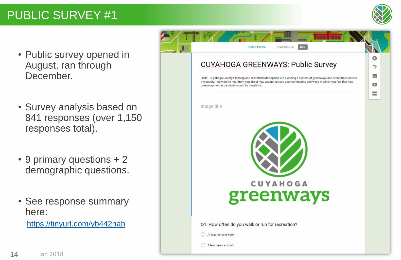
PUBLIC SURVEY #1
• Public survey opened in August, ran through December.
• Survey analysis based on 841 responses (over 1,150 responses total).
• 9 primary questions + 2 demographic questions.
• See response summary here: https://tinyurl.com/yb442nah
Jan 201814

Q1/2/3/4: WALK/RUN/BIKE FOR RECREATION
Jan 201815

Q5: OBSTACLES OR BARRIERS
Jan 201816

Q6: HOW WOULD PEOPLE USE GREENWAYS
Jan 201817

GREENWAY FRAMEWORK
Cuyahoga Greenways
Jan 201818

GREENWAY DESIGN OBJECTIVES
• Accommodate pedestrians and cyclists• Be usable and accessible by all ages and
all abilities wherever feasible• Prioritize for safety• Emphasize off-street routes where
possible• Provide connections to key destinations /
anchors in each community • e.g. commercial node, civic center, major school
sites
• Fill in gaps in the existing trails / greenway network
• Improve and strengthen economic, environmental, and human health
Jan 201819

PrioritiesAlignment with CIP and other projects
FundingImplementation
DATA ENRICHED, COMMUNITY DRIVEN
Planning process uses data and analysis resources to strengthen and empower stakeholder decision-making.
Identification of “CANDIDATE ROUTES”
GreenwaysOff-Street
Open Space
Urban TrailsOn-Street
Constrained FrameworkPlan
StakeholderEngagement
Known opportunitiesGap IdentificationPlanning projects
Technical Analysis
Availability of:Rights-of-Way
Land Properties
Development of“EVALUATION CRITERIA”
Where are the opportunities? How well do candidates meet our goals?
Equity Connectivity
Economic Ecology
StakeholderEngagementWhat are the
priorities & critical issues/factors?
Technical Analysis
Metrics and maps
Jan 201820

CANDIDATE ROUTES - PROCESS
1. Begin with existing bikeways information • (e.g. Greenways Partners data).
2. Identify the significant candidate corridors within Bikeways data.
3. Add/refine and review the network of candidate routes (Project Team, Steering Committee, Public Input).• Link to “community nodes” in each municipality• Link to regional assets and open spaces
4. Identify regional routes versus supporting and/or more localized routes.
Jan 201821
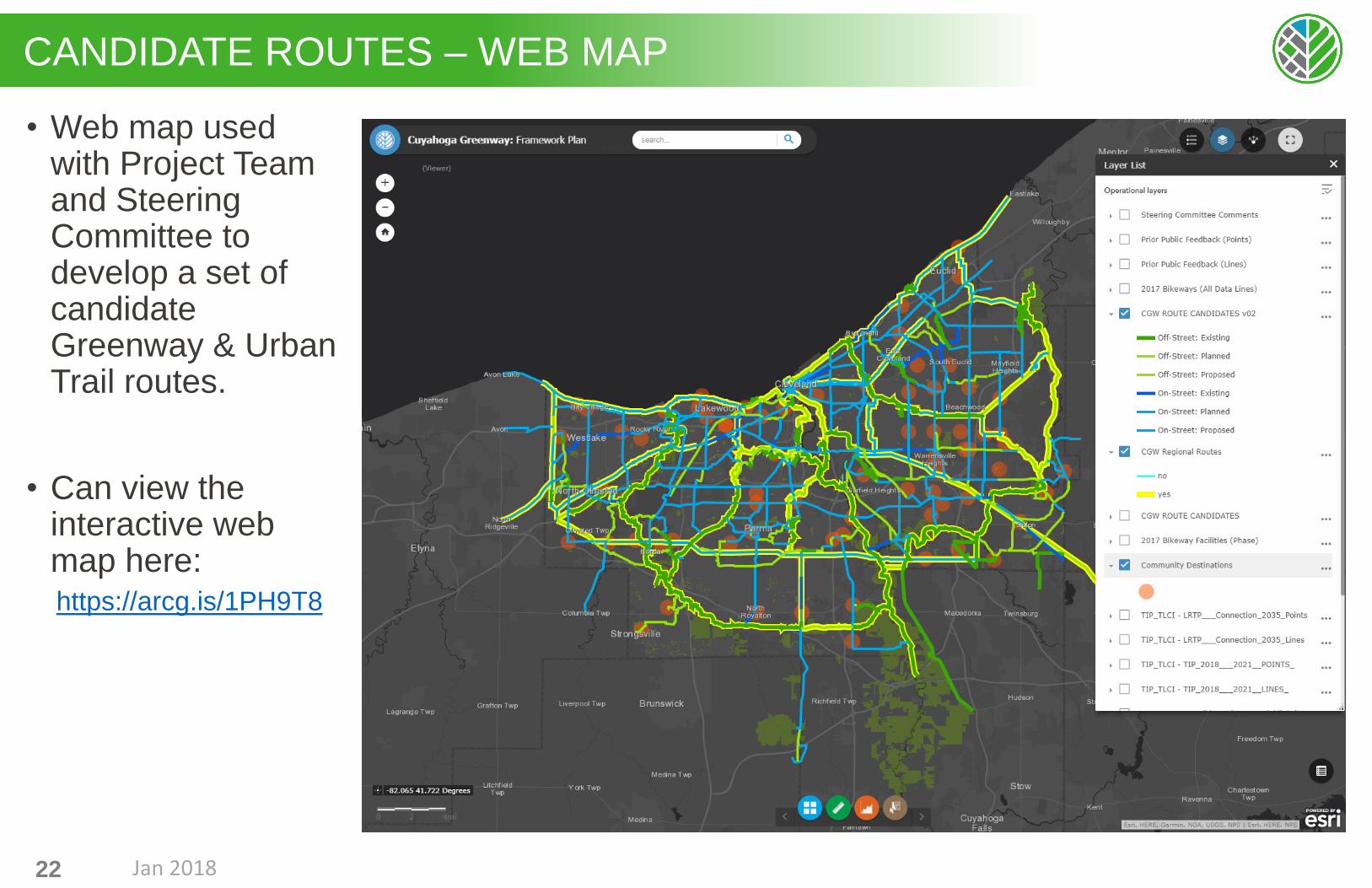
CANDIDATE ROUTES – WEB MAP
• Web map used with Project Team and Steering Committee to develop a set of candidate Greenway & Urban Trail routes.
• Can view the interactive web map here:https://arcg.is/1PH9T8
Jan 201822

CANDIDATE ROUTES - CURRENT
23
Includes on- and off-street routes.
Includes existing,planned, and proposed routes.
In some cases, may be desire to upgrade existing facility to a higher level facility.
Jan 2018
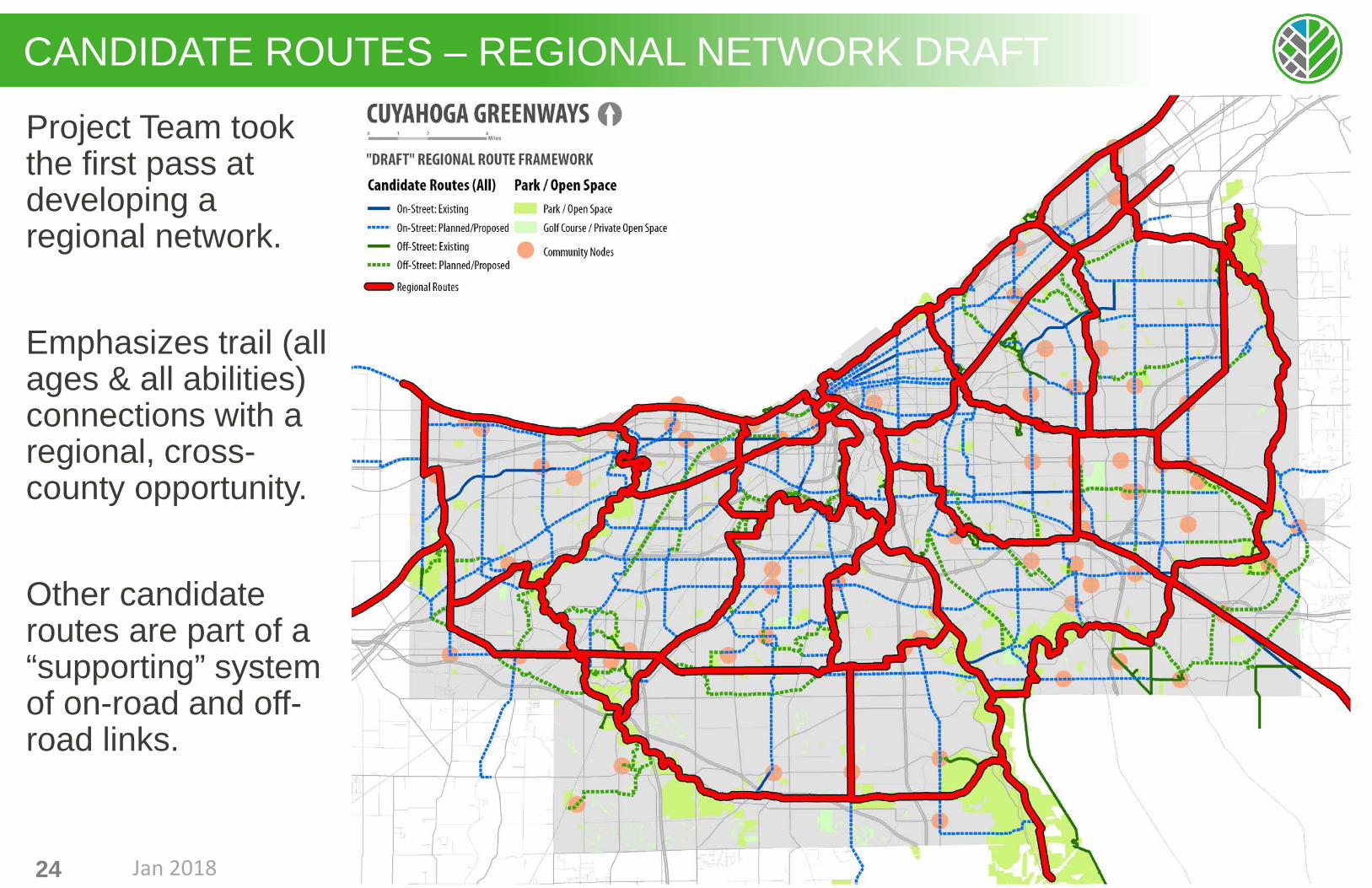
CANDIDATE ROUTES – REGIONAL NETWORK DRAFT
24
Project Team took the first pass at developing a regional network.
Emphasizes trail (all ages & all abilities) connections with a regional, cross-county opportunity.
Other candidate routes are part of a “supporting” system of on-road and off-road links.
Jan 2018

CANDIDATE ROUTES – REGIONAL NETWORK DRAFT
25
Many of the regional candidate routes still need to be implemented.
Regional Trails – Existing• Establish all purpose trails
(e.g. Emerald Necklace Metorpark trails)
Regional Trails –Recommended
• Primarily filling gaps in the existing trail network (e.g. Lake Front, Downtown Connectors)
Regional Bikeways –Recommended
• Primarily within road corridor. Desire for separated facilities where feasible.
• May or may not be all-ages and all-abilities appropriate (e.g. Chagrin River Rd.)
Jan 2018

PrioritiesAlignment with CIP and other projects
FundingImplementation
DATA ENRICHED, COMMUNITY DRIVEN
Planning process uses data and analysis resources to strengthen and empower stakeholder decision-making.
Identification of “CANDIDATE ROUTES”
GreenwaysOff-Street
Open Space
Urban TrailsOn-Street
Constrained FrameworkPlan
StakeholderEngagement
Known opportunitiesGap IdentificationPlanning projects
Technical Analysis
Availability of:Rights-of-Way
Land Properties
Development of“EVALUATION CRITERIA”
Where are the opportunities? How well do candidates meet our goals?
Equity Connectivity
Economic Ecology
StakeholderEngagementWhat are the
priorities & critical issues/factors?
Technical Analysis
Metrics and maps
Jan 201826

EVALUATION CRITERIA
Socioeconomic Need- Population served- Equity & at-risk factors- Car ownership
“NETWORK FUNCTION” Opportunity- Hierarchy (regional vs.
local)- Gap-filling (connects to existing facilities)
Access to Transit Services Opportunity
Physical Safety Need- Crime- Bike/Ped. Crashes
Community Asset Proximity Opportunity- Jobs + Schools- Retail / Entertainment- Cultural Centers
Habitat Protection Opportunity- Within natural areas, riparian corridors, floodplains, etc.
Restoration Opportunity- Proximity to natural land covers.- Within/near vacant or underused land areas
Stormwater Opportunity and/or Need- % Impervious cover- Infiltration potential
Visual CharacterNeeds- Industrial, low-canopy cover, on major roadwayOpportunity- Scenic, high-canopy cover
Health & Wellness Need- Activity Levels- Fitness participation
Open Space Opportunity- Routes that link to open spaces
27
Each box reflects a specific analysis.
Open Space Need- Locations where access to open space is low
Experience Need- Steep slopes- Major road crossings
EQUITY CONNECTIVITY ECONOMIC ECOLOGY
Jan 2018

EVALUATION EXAMPLE - POPULATIONStep 1:Map census Population Data (Block-level)
Jan 201828

EVALUATION EXAMPLE - POPULATIONStep 2:Translate into quarter-mile grid to determine population density (total population per grid cell)
Jan 201829

EVALUATION EXAMPLE - POPULATIONStep 3:Overlay candidate routes
Jan 201830

EVALUATION EXAMPLE - POPULATIONStep 4:Determine total population along a route within a target distance (e.g. half-mile)Calculate totals based on the route length to get average population density along the route.
Jan 201831

HOW WILL THE EVALUATION BE USED?
ANALYSIS USED to informdecisions (not make decisions)
Draw attention to areas of needin the community
Draw attention to areas of opportunity
Assess implementation feasibility
32 Jan 2018

NEXT STEPS
Cuyahoga Greenways
Jan 201833

NEXT STEPS
• Collect Community Feedback from meeting series #2
• Project team will incorporate feedback into the greenway framework and conduct a preliminary evaluation of route options.
• Steering Committee Meetings in late April / early May to review and refine framework.
• Community Meetings #3: Mid- to Late-May• Times and locations TBD
34 Jan 2018

CUYAHOGA GREENWAY PARTNERS
The Cuyahoga Greenway Partners is a collaboration to facilitate communication, keep focus and drive the regional trail effort raising the visibility, prioritization, funding methods and implementation of relevant actions in order to complete the recreation, transportation-choice network.
35
Active member organizations include:• Bike Cleveland• Cleveland Metroparks• Cleveland Planning Commission (CPC)• Cuyahoga County Board of Health (CCBH)• Cuyahoga County Planning Commission
(CCPC) and Public Works (PW)• Cuyahoga Valley National Park (CVNP)• Greater Cleveland Regional Transit
Authority (GCRTA)• Northeast Ohio Areawide Coordinating
Agency (NOACA)• Northeast Ohio Regional Sewer District
(NEORSD)• Rails-to-Trails Conservancy (RTC)• The Trust for Public Land (TPL)
Jan 2018

THANK YOU
Jan 201836