dale bradley's landscape architecture portfolio
DESCRIPTION
A collection of works from Kansas State UniversityTRANSCRIPT

DALE BRADLEYLANDSCAPE ARCHITECTURE PORTFOLIO

2
SELECTED WORKS
KANSAS STATE UNIVERSITYMASTER OF LANDSCAPE ARCHITECTURE
CONTACT:7612 MAPLE PRAIRIE VILLAGE, KANSAS [email protected]
DALE BRADLEY

3
CONTENTSWACO PARK 4
6
10
14
WYUKA PARK
TRANSFORMING TRUMAN
MASTER’S PROJECT
18NIGHT PHOTOGRAPHY AND SKETCHES
20PROFESSIONAL EXPERIENCE
4
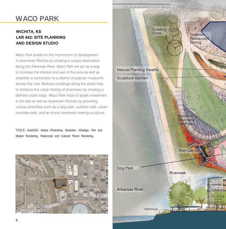
Waco Park builds on the momentum of development
in downtown Wichita by creating a unique destination
along the Arkansas River. Waco Park will act as a way
to increase the interest and use of the area as well as
establish a connection to a district of popular museums
across the river. Multiuse buildings along the street help
to enhance the urban feeling of downtown by creating a
defined urban edge. Waco Park helps to spark investment
in the site as well as downtown Wichita by providing
unique amenities such as a dog park, outdoor café, urban
riverside park, and an iconic overhead viewing sculpture.
WICHITA, KSLAR 442: SITE PLANNING AND DESIGN STUDIO
WACO PARK
Dog Park
Arkansas River
Sculpture Garden
Natural Planting Swaths
TOOLS: AutoCAD, Adobe Photoshop, Illustrator, InDesign, Pen and
Marker Rendering, Watercolor and Colored Pencil Rendering.
Keystone Sculptural Overhead
Rain Garden
Riverwalk
Existing Elms Outdoor
Restaurant Dining
gDoDoDoDoDoDoDDog ggggggggggggg PaPaPaaaPPaPaPaPaarkrkrrkrkrk
AArArAArArArkkkakakakakansnsnsnsasasasas RRRRRRRRiiiiiviviviverererrrreree
RRRiRRRRRRRRRRR vvvvevevevv rwrwrwwaalalalala kkkkkkkkkkkkkk1st St
Wac
o S
t
Arkansas River
Douglas Ave
CONTEXT MAP
5
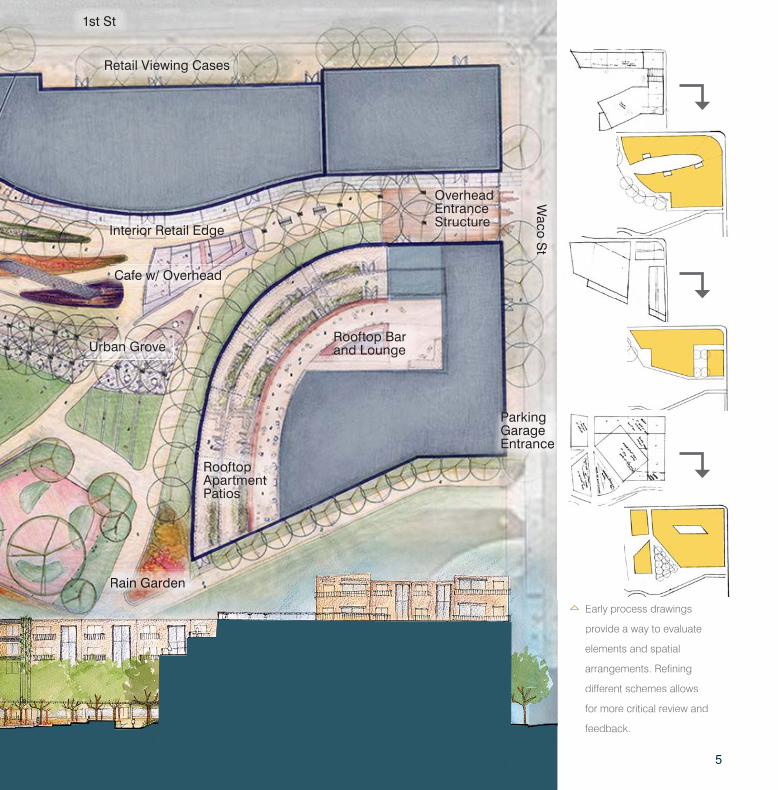
Urban Grove
Early process drawings
provide a way to evaluate
elements and spatial
arrangements. Refining
different schemes allows
for more critical review and
feedback.
Rooftop Bar and Lounge
Rooftop Apartment Patios
Interior Retail Edge
Cafe w/ Overhead
Overhead Entrance Structure
Retail Viewing Cases
Rain Garden
1st St
Waco S
t
RRaRaRRaRaRaRaRaRaRaRaRaRaRaRaRaRaRaaRRRaRaaaRRRR inininninininnnnnnnininininininnninnnnnnnnnnnnnnnnnnnnnnnnnnnnnnnnnnninn GGGGGGGGGGGGGGGGGGGGGGGGGGGGararararrrraaraaararddddddddedededededddeddededeeddeedededeeeeeeeeeeeennnnnnnnnnnnnnnnnnnnnnnnnnnnnnnnn
Parking Garage Entrance

6
Wyuka Park’s project objectives focus on creating a
community gathering space in conjunction with cemetery
proceedings. The organization of spaces help to support
events of celebration and sorrow. The strategic planting
design provides opportunities for people to experience
a range of visual aesthetics which build on the variety of
sensual and emotional feelings and activities that will be
taking place at Wyuka Park. Once established, the planting
scheme is designed to reduce water runoff while requiring
limited maintenance and irrigation. Prairie areas mimic the
natural prairie which can be used as a tool for education,
allowing people to understand how native planting can be
stunning and sustainable. Wyuka Park builds community
through celebration, tribute, and leisure.
LINCOLN, NELAR 646: PLANTING DESIGN STUDIO & DESIGN IMPLEMENTATION I
WYUKA PARK CEMETERY
Bioswale and Retention Area
Drop Off Drive
Entry Plaza
TOOLS: AutoCAD, Adobe Photoshop, Illustrator, and InDesign.
Permeable Parking Pavers
O St
33rd
St
CONTEXT MAP
7
The bloom chart demonstrates
the relationship between
bloom times and the plant’s
respective colors. Other
considerations for the planting
palette include: scent, texture,
ability to attract wildlife,
maintenance requirements,
accessibility, resilience, and
natural and aesthetic value.
Jan. June Dec.
Park Pavilion
Bioretention Area
Naturalized Prairie Area
Water Feature
Riparian Buffer
Patio
Pond
Swan House
Shaded Lawn
Shaded Lawn
Bioswale Cemetery

8
The natural prairie area acts as a visual buffer
between the pavilion and the cemetery while providing
opportunities for the education of native plantings.
The entry plaza frames visitors’ views to the pavilion
while creating a threshold that helps to
form the main plaza space.
A technical grading plan and planting was created to
detail Wyuka Park’s design. Creating these technical
documents along side each other allows for careful
planning of sustainable water management.

9
10
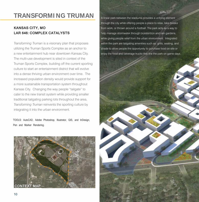
Transforming Truman is a visionary plan that proposes
utilizing the Truman Sports Complex as an anchor to
a new entertainment hub near downtown Kansas City.
The multi-use development is sited in context of the
Truman Sports Complex, building off the current sporting
culture to start an entertainment district that will evolve
into a dense thriving urban environment over time. The
increased population density would provide support for
a more sustainable transportation system throughout
Kansas City. Changing the way people “tailgate” to
cater to the new transit system while providing smaller
traditional tailgating parking lots throughout the area,
Transforming Truman reinvents the sporting culture by
integrating it into the urban environment.
KANSAS CITY, MOLAR 646: COMPLEX CATALYSTS
TRANSFORMING TRUMAN A linear park between the stadiums provides a unifying element
through the city while offering people a place to relax, take breaks
from work, or thrown around a football. The park acts as a way to
help manage stormwater through bioretention and rain gardens,
while giving people relief from the urban environment. Integrated
within the park are tailgating amenities such as: grills, seating, and
shade to allow people the opportunity to purchase food on site or
enjoy the food and beverage trucks that line the park on game days.
TOOLS: AutoCAD, Adobe Photoshop, Illustrator, GIS, and InDesign,
Pen and Marker Rendering.
I-70I-70
I-43
5
CONTEXT MAP

11
Phase one development begins
around the stadiums with sports
related business while building
a base of population. Phase
two forms the linear park while
developing further along the
proposed transit route. The
following phases further develop
the residential areas while
building out from the linear park
and transit route.

12
The plan helps convey the relationship between the proposed
urban environment and the existing stadiums. A light rail
system is integrated through the two central main streets
to help activate the businesses around the area while
connecting the site to the surrounding region.
A regional scale diagram shows other proposed
development by Complex Catalysts as well
as the new public transit route to connect envisioned
development to downtown Kansas City.
Google can act as an anchor for a new business district
while helping to build upon the high speed cables,
Google Fiber, installed in the area.Adapted from diagram by Kraig Weber
ResidentialRetailMixed UseGreen spaceHydrology
TransformingTrumanSite Boundary

13
Connection to Blue River Through Natural Park
Connection to Future Development Over Pedestrian Oriented Bridge with Light Rail
Mass Transit Route
Mass Transit Route
Stadium Plaza
Arrowhead Stadium
I-70
Stadium Dr
Raytown Rd
Blu
e R
idge
Cut
off
I-70
I-435
Kauffman Stadium
Natural Park
Park
Chiefs Training Facility
Pedestrian Path along Rock Island Corridor
School
Hotel
GoogleOffice
Hotel
Linear Park
Linear Park

14
Abstract: Anthropocentric disturbances are often the main driver behind the
population decline of wildlife species. Bat species are of particular concern recently
with large declines in populations worldwide. The conservation of bat species relies on
knowledge about the relationship between species-specific needs and the effect urban
environments have on individual species. Mexican Free-Tailed Bats (MFTBs) are listed
on the IUCN Red List and play an important role in many ecosystems within the United
States. Austin, Texas is home to the largest urban bat colony in the world, including
MFTBs. Austin can continue to benefit from millions of dollars from ecotourism bat
viewing sites and the natural control of insect populations provided by this species if
urbanization does not cause a reduction in their population. The focus of this research
is to develop a quantitative habitat suitability model for the MFTBs in urban areas to
increase the understanding of possible MFTB habitat in the Austin Metropolitan area.
A geographical information system was used to map the suitability of habitats for MFTBs
in urban areas based off a typology for the needs of the species, which was created
through a literature review of expert knowledge. This study will help to quantify the
relationship between urban environments and the MFTBs, showing that urban areas in
the Austin Metropolitan area are suitable for the species. A predictive model, like the one
described here, can act as a crucial assessment and planning tool for bat conservation
by helping to eliminate challenges of tracking populations or identifying bats during
nocturnal activities.
This model informs the proposal of planning and design policy changes in Austin, Texas
to better support MFTB’s habitat needs. Adjustments to current site plans in Austin are
explored understand the effect the proposed MFTB planning policies could have on
current development while exploring the application of the MFTB typology at a site scale.
Application of the understanding created through habitat-suitability modelling helps to
visualize how current projects in Austin, Texas can better support MFTBs to create an
understanding of how these policies may affect the development of urban environments.
Planning for Wildlife: An Urban Planning and Design Exploration to Support Mexican Free-Tailed Bats
MASTER’S PROJECT
The suitability model was built off
individual landscape elements
relationship with Mexican Free-Tailed
Bats. The combined analysis creates
an understanding of the landscapes
suitability for the species. From the
top the layers in the analysis are
edge density, foraging preferences,
building height, distance to
highways, distance to water, and
roost density.

15
Suitability:
HighLow
Austin Metropolitan Area Mexican Free-Tailed Bat Suitability
16
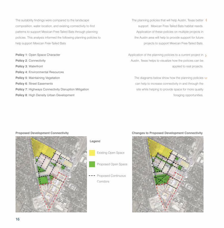
Application of the planning policies to a current project in
Austin, Texas helps to visualize how the policies can be
applied to real projects.
The suitability findings were compared to the landscape
composition, water location, and existing connectivity to find
patterns to support Mexican Free-Tailed Bats through planning
policies. This analysis informed the following planning policies to
help support Mexican Free-Tailed Bats:
Existing Open Space
Legend
Proposed Development Connectivity Changes to Proposed Development Connectivity
Proposed Open Space
Proposed Continuous
Corridors
Policy 1: Open Space Character
Policy 2: Connectivity
Policy 3: Waterfront
Policy 4: Environmental Resources
Policy 5: Maintaining Vegetation
Policy 6: Street Easements
Policy 7: Highways Connectivity Disruption Mitigation
Policy 8: High Density Urban Development
The planning policies that will help Austin, Texas better
support Mexican Free-Tailed Bats habitat needs.
Application of these policies on multiple projects in
the Austin area will help to provide support for future
projects to support Mexican Free-Tailed Bats.
PondPond
The diagrams below show how the planning policies
can help to increase connectivity in and through the
site while helping to provide space for more quality
foraging opportunities.
17
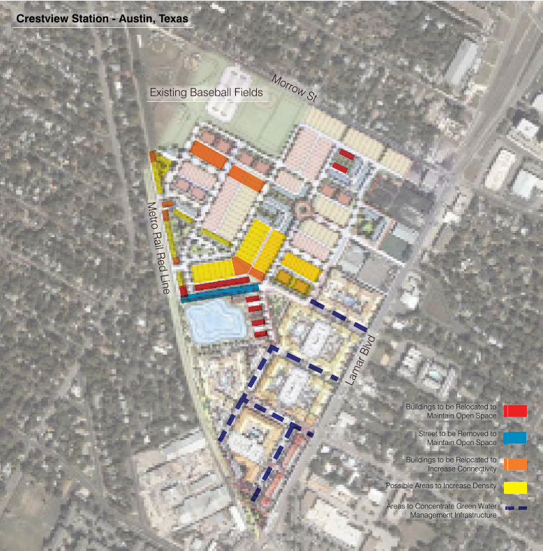
Morrow StExisting Baseball Fields
Metro R
ail Red Line
Lam
ar B
lvd
Crestview Station - Austin, Texas
Buildings to be Relocated to Maintain Open Space
Street to be Removed to Maintain Open Space
Buildings to be Relocated to Increase Connectivity
Areas to Concentrate Green Water Management Infrastructure
Possible Areas to Increase Density

18
NIGHT PHOTOGRAPHY AND SKETCHING
World of Night, a specialization studio, allowed me to explore lighting and design with a focus on the nighttime experience. Utilization of a DSLR camera in low light was an important skill learned in World of Night. Examples of some night photography can be seen to the right. This experience helped me develop techniques for best displaying build or natural mediums. Also, exploring design with a heavy focus on the nighttime experience helped to broaden my understanding of how people use and feel in different spaces.
Sketching is an important skill for conveying information as well as a way to explore a new place or site. Being able to quickly sketch something is one of the most important skills that help me to work with others and communicate design decisions quickly and easily. Two examples of on site sketches can be seen to the far right.
LAR 648: WORLD OF NIGHT

19
20
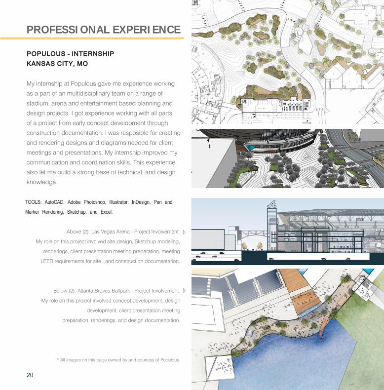
My internship at Populous gave me experience working
as a part of an multidisciplinary team on a range of
stadium, arena and entertainment based planning and
design projects. I got experience working with all parts
of a project from early concept development through
construction documentation. I was resposible for creating
and rendering designs and diagrams needed for client
meetings and presentations. My internship improved my
communication and coordination skills. This experience
also let me build a strong base of technical and design
knowledge.
POPULOUS - INTERNSHIPKANSAS CITY, MO
PROFESSIONAL EXPERIENCE
TOOLS: AutoCAD, Adobe Photoshop, Illustrator, InDesign, Pen and
Marker Rendering, Sketchup, and Excel.
Above (2): Las Vegas Arena - Project Involvement:
My role on this project involved site design, Sketchup modeling,
renderings, client presentation meeting preparation, meeting
LEED requirements for site , and construction documentation.
Below (2): Atlanta Braves Ballpark - Project Involvement:
My role on this project involved concept development, design
development, client presentation meeting
preparation, renderings, and design documentation.
* All images on this page owned by and courtesy of Populous.
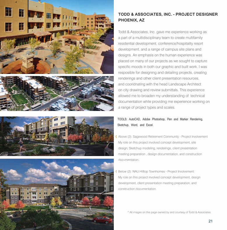
Todd & Associates, Inc. gave me experience working as
a part of a multidisciplinary team to create multifamily
residential development, conference/hospitality resort
development, and a range of campus site plans and
designs. An emphasis on the human experience was
placed on many of our projects as we sought to capture
specific moods in both our graphic and built work. I was
resposible for designing and detailing projects, creating
renderings and other client presentation resources,
and cooridnating with the head Landscape Architect
on city drawing and review submittals. This experience
allowed me to broaden my understanding of technical
documentation while providing me experience working on
a range of project types and scales.
TODD & ASSOCIATES, INC. - PROJECT DESIGNERPHOENIX, AZ
TOOLS: AutoCAD, Adobe Photoshop, Pen and Marker Rendering,
Sketchup, Word, and Excel.
Above (2): Sagewood Retirement Community - Project Involvement:
My role on this project involved concept development, site
design, Sketchup modeling, renderings, client presentation
meeting preparation , design documentation, and construction
documentation.
Below (2): NAU Hilltop Townhomes - Project Involvement:
My role on this project involved concept development, design
development, client presentation meeting preparation, and
construction documentation.
* All images on this page owned by and courtesy of Todd & Associates.
21

THANK YOU FOR YOUR CONSIDERATION
CONTACT:7612 MAPLE PRAIRIE VILLAGE, KANSAS [email protected]
DALE BRADLEY