ddss--3377 - pwaportal.ventura.orgpwaportal.ventura.org/esd/dis/docs/2016-17. revised...
TRANSCRIPT

DDSS--3377
The following items should be included in the Grading Plan Submittal application packet:: □ DS-37 (this form-box checked) □ Completed Application Form (Must be signed by the applicant) □ Plan Check Deposit/Fee For current deposit/fee amount, see: “Schedule of Processing Fees & Deposits.” □ Soils Report Review Deposit/Fee For current fee amount, see: “Schedule of Processing Fees & Deposits.” □ Geology Report Review Deposit/Fee (if needed) For current fee amount, see: “Schedule of Processing Fees & Deposits.” □ Two Copies Soils Report □ Two Copies of Geology Report (if needed) □ Two Copies of Grading Plans – 24” x 36” – Ventura County Grading Plan Title Sheet (CAD file available) □ One Copy of Authorization of Agent, if applicable □ DS-29, Acknowledgement Concerning the Employment of a Registered Civil Engineer and Technical Consultants (Signed by all engineers and owner) if applicable □ One Copy of DS-30 (off-site construction permission) if required □ One Copy of DS-35 (grading plan checklist for plan check) The following items must be presented either at initial submittal, or prior to approval of the grading plan: □ Construction Inspection Deposit. For current deposit amount, see: “Schedule of Processing
Fees & Deposits.” Applicant is responsible for the actual cost of inspection.
□ One copy of the appropriate Stormwater Quality form(s) SW-1, SW-2 SWHR et al □ DS-251 Stormwater Permit Requirements for New Development and Redevelopment Questionnaire Project Representative (if other than owner or engineer): Name Address City State __ Phone
GRADING PERMIT Initial Single Lot Grading Plan Submittal
800 South Victoria Avenue, Ventura, CA 93009-1600
http://countyofventura.org


GRADING PERMIT PLAN CHECK AND PROCESSING
DEPOSIT AGREEMENT
Grading Permit No. ____________
I, , hereby authorize the County of Ventura to plan check and process the above referenced Grading Permit in accordance with the 2013 Edition of the Ventura County Building Code and A Resolution of the Board of Supervisors of the County of Ventura Establishing Public Works Agency Processing
Fees Relating To Grading Permit Plan Review and Inspection Services and for
Various Land Development Projects, dated May 19, 2015.
I am depositing in U.S. dollars the amount of $ _____________ which is for the grading plan check as indicated in the Payment Option Plan which is to pay for the actual County staff time to plan check and process my grading permit request. In making this deposit, I acknowledge and understand that the deposit may cover all or a portion of the total plan check and processing costs. I also understand that these costs apply even if the grading permit application is withdrawn or not approved.
I further agree to the following terms and conditions of this Agreement:
1. Staff time from County of Ventura departments spent processing my gradingpermit plan check will be billed against this deposit using contract hourly rates.“Staff Time” may also include consultant fees if the County needs to have the
project reviewed by consultants.
2. If plan check and processing costs exceed the available deposit, I will receiveperiodic invoices payable upon receipt. The County may suspend review of theGrading Permit until the invoices are paid.
3. If the total actual plan check and processing cost is less than the availabledeposit fee, the unused portion of the deposit will be applied toward the nextrequired deposit or refunded to the applicant who signed this Agreement.
4. If the total actual plan check and processing cost is more than the deposit on filewith the County of Ventura Public Works Agency, I agree to pay the differenceaccording to the terms set by the Public Works Agency.
5. I may request a further breakdown or itemization of County invoices, but such arequest is independent of the payment obligation and time frames. All requestsmust be received within 6 months of the charges being made.
6. Once the County completes the plan check phase for which the deposit is made,if additional plan check charges are anticipated to exceed the deposit the County
1
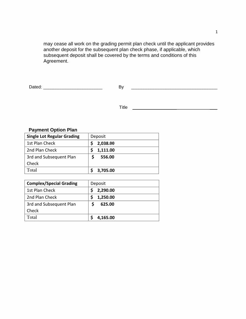
may cease all work on the grading permit plan check until the applicant provides another deposit for the subsequent plan check phase, if applicable, which subsequent deposit shall be covered by the terms and conditions of this Agreement.
Dated: ________________________ By ___________________________________
Title __________________ ___
Payment Option Plan Single Lot Regular Grading Deposit
1st Plan Check $ 2,038.00
2nd Plan Check $ 1,111.00
3rd and Subsequent Plan
Check
$ 556.00
Total $ 3,705.00
Complex/Special Grading Deposit
1st Plan Check $ 2,290.00
2nd Plan Check $ 1,250.00
3rd and Subsequent Plan
Check
$ 625.00
Total $ 4,165.00

__
_
_
_
_
_
_
_
County of VenturaGRADING PERMITPUBLIC WORKS AGENCY Permit No. __________
DEVELOPMENT AND INSPECTION SERVICES800 South Victoria Avenue, Venutra, CA 93009
(805) 654-2030
Description of Grading Work ___________________________________________________________________________ Blasting Yes □ No □ Per Ventura County Drawing Nos._______________________________________________________________________________________________ Address of Job ______________________________________________________________________________________________________________ Assessor Parcel No. _________________________________________________________________________________________________________ Stage Grading □ Regular Grading □ Engineered Grading □ Depth of Cut ______________________ Excavation___________________yds. Destination of Surplus__________________ Height of Fill ______________________ Fill_______________yds. Import_____________yds. Export ______________ yds. Source of Import_____________________________________________________________________________________________________________ Grading Plan Check Fee $ _____________________________ Date Paid ______/______/______ Receipt No. ____________________________ Grading Permit Fee $______________________________ Date Paid ______/______/______ Receipt No. ____________________________
Bond Amount $______________________________ Bond No. ____________________ Bond Agency ___________________________ Inspection Required Yes □ No □ "As-Builts" Required Yes □ No □
Deviations from Grading Ordiance ______________________________________________________________________________________________ __________________________________________________________________________________________________________________________
PERMITTEE SHALL NOTIFY SUBDIVISION INSPECTION48 HOURS PRIOR TO WORK
Property Owner _______________________________________________________Phone ______________________________ Address _____________________________________________________________City _______________________________ Zip _______________ Contractor __________________________________________________________ Phone ______________________________ Address ____________________________________________________________ City ________________________________ Zip _______________ Supervising Civil Engineer _____________________________________________ Phone ______________________________ Address ____________________________________________________________ City ________________________________ Zip _______________ Soils Engineer ________________________________________________________Phone ______________________________ Address ____________________________________________________________ City ________________________________ Zip _______________ Engineering Geologist __________________________________________________Phone ______________________________ Address ____________________________________________________________ City ________________________________ Zip _______________
This permit authorizes only that work described hereon. Neither the issuance if this permit, nor the compliance with the provisions hereof or with any conditions imposed by this permit shall relieve any person form responsibility for damage to other persons or property nor impose any liability upon the governing agency for damage to other persons or property. All attached addenda are a part of this permit. All modifications of this permit or of the approved grading plan must be approved by the governing agency.
I hereby acknowledge that I have read this application and state that the above is correct, and that all excavation, grading and filling of land shall be in accordance with the approved plans, and the applicable grading ordinance. In consideration of the County issuing this grading permit the permittee agrees to comply with all provisions of this permit inclluding the standard conditions and special conditions attached hereto.
Your permit is not complete until "NOTIFICATION OF COMPLETION" is issued. Occupancy clearance does not mean that your project is complete. X Signature ______________________________________________ Print Name _______________________________ Date __________________
PROPERTY OWNER Permit Issued by: __________________________________________ Date Permit Issued _________________________ Expiration Date _________
This permit expries 12 months after issuance unless specified otherwise on this permit.
WORKMAN'S COMPENSATION It is required that each applicant file the following:
1. A certificate of consent to self-insure issued by the Director of Industrial Relations, or2. A certificate of Workman's Compensation Insurance issued by an admitted insurer, or3. An exact copy certified by the Director of Industrial Relations or the insurer, or
Workman's Compensation Insurance Policy No. __________________________________________________________ Expiration Date _________4. Statement of Understanding:
"I certify that in the performance of the work for which this permit is issued, I shall not employ any person in any manner so as to become subjectto the Workmen's Compensation Laws of California. I further certify that I will verify compliance with the Workman's Compensation Laws of Californiaof all sub-contractors contracted by me for any participation on projects over which I have contractual jurisdiction."
I declare under penalty of perjury that the foregoing is true and correct.
X Signature __________________________________ Date _______________
FILL IN ALL BLANKS. IF NOT APPLICABLE, ENTER THE WORD "NONE"Applicant should read "Standard Conditions" - see following sheet
PWA-143 (Rev. 9/97)

STANDARD CONDITIONS
1. Grading shall be in accordance with Ventura County Building Code which adopts by reference UBC Chapter 33, Excavation and Grading, and the Ventura CountyStandard Land Development Specifications and the Land Development Manual.
2. Plan check and inspection fee deposits shall be made in accordance with the Board of Supervisor’s adopted Fee Deposit Schedule. The permittee shall pay theactual costs (including overhead) for services rendered. If at any time the actual costs exceed the deposits, the permittee shall pay the balance due beforeproceeding with further work. Failure to remit payment when due may result in the County recording a Non-Compliance against the parcel. Deposits not used willbe refunded to the permittee upon completion of all required work.
3. All recommendations made by the soils engineer (and engineering geologist, where employed) contained in the reports referenced hereon as approved orconditioned by the County shall be a part of this grading plan.
4. All graded surfaces subject to erosion shall be protected as approved by the building official. Protection shall be provided and fully functional prior to finalapproval of grading as completed, issuance of a certificate of occupancy, or utility clearance for any building on the site, whichever occurs first.
5. All deleterious material, i.e., lumber, logs, brush, or any other organic materials or rubbish, shall be removed from all areas to receive compacted fill.
6. Unsuitable material shall be removed as required by the soils engineer (and engineering geologist, where employed) from all areas to receive compacted fill ordrainage structures.
7. All areas to receive compacted fill shall be inspected and approved by the soils engineer (and engineering geologist, where employed) after removal of suitablematerial and excavation of keyways and benches, and prior to placement of subsurface drainage systems for any fill.
8. All soils or rock materials deemed unsuitable for placement in compacted fill shall be removed from the site. Any material such as concrete or imported materialsshall be approved by the soils engineer prior to use in compacted fill. Where excavated material is blocky it will be broken into suitable particle sizes, none largerthan 12 inches in largest dimension, before being used as fill in conformance with Sec. 3313 of the UBC.
9. The soils engineer shall direct the removal or treatment of any existing underground structures such as septic tanks, irrigation lines, etc.
10. Any water well located within the site shall be reported to the Health Department of Ventura County prior to its modification or destruction. Special procedures arerequired for abandonment.
11. All excavated back slopes and keys for buttress fills must be examined by the engineering geologist and soils engineer to insure that all potential planes of failurehave been exposed in the excavation and will be adequately supported by the proposed buttress. Field certification to be submitted by the consultants.
12. Storm damage prevention measures or preventative devices required by the building official shall be installed by November 1 or as grading progresses andmaintained until April 15 of the succeeding year or unless early removal is agreed to by the building official.
13. The soils engineer shall submit recommendations for corrective work to insure slope stability where unstable material is exposed at the top of cuts.
14. Unless otherwise specified, corrugated steel pipe shall be bituminous coated in accordance with standard land development specifications (SLDS).
15. Terrace drains, interceptor drains and downdrains shall be constructed of 3” P.C.C. (or gunite) reinforced with 6” x 6” x 10 x 10 W.W.M and shall be of either semicircular or triangular cross section.
16. Materials for interceptor drains, terrace drains and downdrains shall meet standard land development specifications, subsection 201-1 and 400 except that theconcrete lined swales, V-ditches, paved terrace drains, downdrains, berms, velocity reducers and other erosion protection devices shall be of Class 470-C-2000unless otherwise specified.
17. Interim soils and geologic reports shall be submitted to the County as required by the building official.
18. “As-built” soils engineering (and if applicable, engineering geology) reports, summarizing all work performed and concluding that fills have been placed accordingto the approved plans and stating that all geologic features are grossly stable as graded shall be submitted to the County prior to approval of the rough grading bythe building official.
19. That all work contemplated under the permit will be completed within the time limit specified in the permit or any time extensions granted thereon and will be done in accordance with approved plans and in compliance with the terms and conditions of the grading permit to the satisfaction of the Director of Public Works and allof the provisions of the Code, applicable laws, and ordinances.
20. That for a period of one year after the issuance of the certificate of completion that principal shall perform all maintenance and comply with all conditions requiredunder the permit.
21. That in the event the principal fails to comply with the provisions of the permit and all applicable laws, the surety will promptly complete the work to thesatisfaction of the Director of Public Works. In the event said surety fails to promptly do so, the surety will pay the County all costs and expenses incurred by saidCounty in making the premises safe to the satisfaction of the Director of Public Works.
22. Any work performed under this permit prior to notifying Development and Inspection Services as to the start of work will be subject to whatever action includingrestoration to conditions existing before work was begun, that the County of Ventura deems necessary to inspect, correct and/or approve said work.
23. This permit is valid only to the extent of Ventura County Grading Ordinance Permits required by other interested Agencies and consent of other interestedAgencies and consent of the underlying fee owner of easement and that of easement holders shall be the responsibility of the permittee.
24. If the property subject to this permit changes ownership, the permittee should advise the new owner to contact Development and Inspection Services concerning theneed for a transfer of the permit.
25. If the owner wishes to change the Civil Engineer or technical consultants the owner must provide a release letter from the engineer or consultant and contactDevelopment and Inspection Services.
26. A preconstruction conference of all interested parties shall be held prior to any construction or grading.

COUNTY OF VENTURA
AUTHORIZATION OF AGENT TO ACT ON PROPERTY OWNER'S BEHALF
I hereby authorize the person identified below to act as my agent to apply for, sign, and file the documents necessary to obtain the permits required for my project (excluding the Notice to Property Owner, the execution of which I understand is my personal responsibility). My agent should receive copies of all notices and communications related to my project unless I have otherwise notified the County.
Project Description: __________________________________________________ __________________________________________________ __________________________________________________
(Include Permit # if available)
Project Location: _____________________________________________________ _____________________________________________________ _____________________________________________________ (Address, APN and other property identification as needed)
Name of Authorized Agent: _____________________________________________ (Please Print)
Address of Authorized Agent: ___________________________________________
Phone Number of Authorized Agent: _____________________________________
E-Mail Address of Authorized Agent: _____________________________________
PROPERTY OWNER ACKNOWLEDGEMENT I declare under penalty of perjury that I am the property owner for the address listed above and I personally filled out the above information and certify its accuracy. Further, I agree that I and my agent will abide by all ordinances of the County of Ventura and that any approvals granted for this project will be carried out in accordance with the requirements of the County of Ventura.
Property Owner’s Name: ________________________________________________ (Please Print)
Property Owner's Signature: _____________________________ Date: ___________
Property Owner’s E-Mail Address: _________________________________________
Property Owner’s Phone Number: _________________________________________
Note: A copy of the owner's driver's license, notarization, or other verification acceptable to the agency must be submitted with this form to verify property
owner's signature. The owner must be as shown on the latest Assessor records.
Verification of Property Owner Signature: Driver License Notarized Letter Other
Staff Signature Date

DS-29 Permit No. Date Issued
COUNTY OF VENTURA ACKNOWLEDGEMENT CONCERNING THE EMPLOYMENT OF A REGISTERED
CIVIL ENGINEER AND TECHNICAL CONSULTANTS
Address/Location of Property Tract No. or Legal Description
The Owner(s) of the above described property hereby acknowledge that, as a condition of the Grading Permit and during all work authorized by said permit, a Registered Civil Engineer will be retained to be in responsible charge of the work and perform the duties of Civil Engineer in accordance with requirements of the Grading Ordinance and the Land Development Manual, and further, that a Soils Engineer and/or Engineering Geologist will be employed to make test, investigations, perform inspections and file the reports that are or may be required for compliance with said Ordinance and Manual.
Should new consultants be hired following approval by the County of the original reports and grading plan, the new consultants shall be bound by the grading plan and recommendations contained therein. If the plan, recommendations or work completed are not acceptable to the new consultants they shall provide a new report with recommendations and supporting data which must then be incorporated on a revised plan to be submitted for approval to the County. The Grading Contractor shall, upon completion of grading, be required to provide certification of his work according to the form shown by Plate 8B-1 of Chapter 8.
Owner(s) Signature Date Phone Address City
The undersigned verify that they have been retained as stated above and agree to notify the County within 48 hours if such employment is terminated. It is further understood that all Soils and/or Geology Reports are to be coordinated by and submitted to the County by the Civil Engineer.
Civil Engineer Date (Signature)
Firm Reg. No. Address Phone
Soils Engineer Date (Signature)
Firm Reg. No. Address Phone
Engineering Date Geologist (Signature) Firm Cert.No. Address Phone
INSTRUCTIONS: This document must be completed and filed with the County before the grading permit may be issued. One copy will be returned to each signer when the permit is issued.
PLATE 7A
3/98

DS-30
Rev. 4/2014
Development Services Division Engineering Services Department Public Works Agency County of Ventura 800 South Victoria Avenue, L-1600 Ventura, CA 93009-1600
Subject: CONSENT TO OFF-SITE CONSTRUCTION Grading Permit No. ______________________
To Whom It May Concern:
I hereby certify that I am the owner of the property described as:
Assessor’s Parcel Number_______________________________________________
Street address ________________________________________________________.
I am aware that my neighbor, ______________________________________, is
requesting to grade on my property as part of grading permit number
___________________________.
I have reviewed the grading plan prepared by
____________________________________, dated __________________________, and
I hereby consent to the grading construction on my property.
I further agree to hold the County of Ventura free and clear of any damage to my
property arising from said construction.
Signature Date
Print Name – Property Owner

BENCH MARK DATA
ENGINEERED GRADING INSPECTION CERTIFICATEJOB ADDRESS OR TRACT NO: ______________________________________________________________________
______________________________________________________________________
______________________________________________________________________
ROUGH GRADING CERTIFICATION(A) BY SOILS ENGINEER
I CERTIFY THAT THE ROUGH GRADING WORK INCORPORATES ALL RECOMMENDATIONS CONTAINED IN THE REPORT OR REPORTS FOR WHICH I AM RESPONSIBLE AND ALL RECOMMENDATIONS THAT I HAVE MADE BASED ON FIELD INSPECTION OF THE WORK AND TESTING DURING GRADING. I FURTHER CERTIFY THAT WHERE THE REPORTS OF AN ENGINEERING GEOLOGIST, RELATIVE TO THIS SITE, HAVE RECOMMENDED THE INSTALLATION OF BUTTRESS FILLS OR OTHER SIMILAR STABILIZATION MEASURES, SUCH EARTHWORK CONSTRUCTION HAS BEEN COMPLETED IN ACCORDANCE WITH THE APPROVED DESIGN.
LOT NOS: __________________________________________________________________________________
__________________________________________________________________________________
SEE REPORTS DATED: _________________________________________________________________________________
_________________________________________________________________________________
_________________________________________________________________________________
FOR TEST DATA, RECOMMENDED ALLOWABLE SOIL BEARING VALUES & OTHER SPECIAL RECOMMENDATIONS.
SOILS ENGINEER _______________________________________________ REG. NO __________________________________ (SIGNATURE)
DATE ________________________
(B) BY ENGINEERING GEOLOGIST
I CERTIFY THAT THE ROUGH GRADING WORK INCORPORATES ALL OF THE RECOMMENDATIONS CONTAINED IN THE REPORT OR REPORTS FOR WHICH I AM RESPONSIBLE AND ALL RECOMMENDATIONS THAT I HAVE MADE BASED ON FIELD INSPECTION OF THE WORK DURING GRADING.
LOT NOS : __________________________________________________________________________________
__________________________________________________________________________________
ENGINEERING GEOLOGIST __________________________________________ CERT. NO. _____________________________ (SIGNATURE)
DATE _________________________ (C) BY CIVIL ENGINEER
I CERTIFY TO THE SATISFACTORY COMPLETION OF ROUGH GRADING INCLUDING GRADING TO APPROXIMATE FINAL ELEVATIONS; PROPERTY LINES LOCATED AND STAKED, CUT AND FILL SLOPES CORRECTLY GRADED AND LOCATED IN ACCORDANCE WITH THE APPROVED DESIGN; SWALES AND TERRACES GRADED READY FOR PAVING; BERMS INSTALLED; AND REQUIRED DRAINAGE SLOPES PROVIDED ON THE BUILDING PADS. I FURTHER CERTIFY THAT WHERE REPORT OR REPORTS OF AN ENGINEERING GEOLOGIST AND/OR SOILS ENGINEER HAVE BEEN PREPARED RELATIVE TO THIS SITE, THE RECOMMENDATIONS CONTAINED IN SUCH REPORTS HAVE BEEN INCORPORATED IN THE DESIGN.
LOT NOS : __________________________________________________________________________________________
__________________________________________________________________________________________
CIVIL ENGINEER ______________________________________________ REG. NO. __________________________________ (SIGNATURE)
DATE ________________________________
GENERAL NOTES: 1. GRADING SHALL BE IN ACCORDANCE WITH THE VENTURA COUNTY BUILDING CODE APPENDIX J AND THE VENTURA
COUNTY STANDARD LAND DEVELOPMENT SPECIFICATIONS AND THE LAND DEVELOPMENT MANUAL.
2. A PRECONSTRUCTION CONFERENCE OF ALL INTERESTED PARTIES SHALL BE HELD PRIOR TO ANY CONSTRUCTION OR GRADING.
3. ALL RECOMMENDATIONS MADE BY THE SOILS ENGINEER (AND ENGINEERING GEOLOGIST, WHERE EMPLOYED)CONTAINED IN THE REPORTS REFERENCED HEREON AS APPROVED OR CONDITIONED BY THE COUNTY SHALL BE APART OF THIS GRADING PLAN.
4. ALL GRADED SURFACES SUBJECT TO EROSION SHALL BE PROTECTED IN ACCORDANCE WITH THE LOCALS.W.P.P.P. AND/OR S.W.P.P.P. PROTECTION SHALL BE PROVIDED AND FULLY FUNCTIONAL AT ALL TIMES.
5. ALL DELETERIOUS MATERIAL, I.E. LUMBER, LOGS, BRUSH, OR ANY OTHER ORGANIC MATERIALS OR RUBBISH, SHALL BE REMOVED FROM ALL AREAS TO RECEIVE COMPACTED FILL.
6. UNSUITABLE MATERIAL SHALL BE REMOVED AS REQUIRED BY THE SOILS ENGINEER AND ENGINEERING GEOLOGIST FROM ALL AREAS TO RECEIVE COMPACTED FILL OR DRAINAGE STRUCTURES.
7. ALL AREAS TO RECEIVE COMPACTED FILL SHALL BE INSPECTED AND APPROVED BY THE SOILS ENGINEER (ANDENGINEERING GEOLOGIST WHERE EMPLOYED) AFTER REMOVAL OF UNSUITABLE MATERIAL AND EXCAVATION OFKEYWAYS AND BENCHES, AND PRIOR TO PLACEMENT OF SUBSURFACE DRAINAGE SYSTEMS OR ANY FILL.
8. ALL SOIL OR ROCK MATERIALS DEEMED UNSUITABLE FOR PLACEMENT IN COMPACTED FILL SHALL BE REMOVEDFROM THE SITE. ANY MATERIAL SUCH AS CONCRETE CONSTRUCTION INERT DEBRIS, OR IMPORTED MATERIALS SHALL BE APPROVED BY THE SOILS ENGINEER AND COUNTY PRIOR TO USE IN COMPACTED FILL. WHERE EXCAVATED MATERIAL IS BLOCKY IT WILL BE BROKEN INTO SUITABLE PARTICLE SIZES, NONE LARGER THAN TWELVE INCHES IN LARGEST DIMENSION, BEFORE BEING USED AS FILL.
9. THE SOILS ENGINEER SHALL DIRECT THE REMOVAL OF ANY EXISTING UNDERGROUND STRUCTURES SUCH AS SEPTIC TANKS, IRRIGATION LINES, ETC.
10. ANY WATER WELL LOCATED WITHIN THE SITE SHALL BE REPORTED TO THE WATER RESOURCES DIVISION, WATHERSHED PROTECTION DISTRICT PRIOR TO ITS MODIFICATION, ABANDONMENT, OR DESTRUCTION.
11. ALL EXCAVATED BACK SLOPES AND KEYS FOR BUTTRESS FILLS MUST BE EXAMINED BY THE ENGINEERINGGEOLOGIST AND SOILS ENGINEER TO INSURE THAT ALL POTENTIAL PLANES OF FAILURE HAVE BEEN EXPOSED IN THEEXCAVATION AND WILL BE ADEQUATELY SUPPORTED BY THE PROPOSED BUTTRESS. FIELD CERTIFICATION TO BESUBMITTED BY THE CONSULTANTS.
12. THE SOILS ENGINEER AND ENGINEERING GEOLOGIST (WHERE EMPLOYED) SHALL SUBMIT RECOMMENDATIONS FOR CORRECTIVE WORK TO INSURE SLOPE STABILITY WHERE UNSTABLE MATERIAL IS EXPOSED AT THE TOP OF CUTS.
13. UNLESS OTHERWISE SPECIFIED, CORRUGATED STEEL PIPE SHALL BE BITUMINOUS COATED IN ACCORDANCE WITH STANDARD LAND DEVELOPMENT SPECIFICATIONS (SLDS).
14. INTERIM SOILS AND GEOLOGIC REPORTS SHALL BE SUBMITTED TO THE COUNTY AS REQUIRED BY THE BUILDINGOFFICIAL.
15. FINAL ROUGH GRADE SOILS ENGINEERING AND (IF APPLICABLE) ENGINEERING GEOLOGY REPORTS SUMMARIZING ALL EARTHWORK PERFORMED AND CONCLUDING THAT THE WORK HAS BEEN COMPLETED ACCORDING TO THEAPPROVED REPORTS SHALL BE SUBMITTED TO THE COUNTY FOR APPROVAL OF THE ROUGH GRADING BY THE BUILDING OFFICIAL.
16. FINAL SOILS ENGINEERING AND (IF APPLICABLE) ENGINEERING GEOLOGY REPORTS SUMMARIZING ALL EARTHWORK PERFORMED SINCE ROUGH GRADING AND CONCLUDING THAT THE WORK HAS BEEN COMPLETED ACCORDING TOTHE APPROVED REPORTS SHALL BE SUBMITTED TO THE COUNTY PRIOR TO FINAL INSPECTION BY THE BUILDINGOFFICIAL.
17. THE TOTAL ESTIMATED DISTURBED AREA OF GRADING AND CONSTRUCTION IS _______ ACRES. PROJECTS THAT ARE1.0 ACRE OR GREATER IN DISTURBED AREA WILL REQUIRE A STORM WATER POLLUTION PREVENTION PLAN (SWPPP)AND NOTICE OF INTENT (NOI) AS APPROVED BY THE STATE REGIONAL WATER QUALITY CONTROL BOARD. PROJECTSUNDER 1.0 ACRE WILL REQUIRE A LOCAL STORM WATER POLLUTION PREVENTION PLAN (LSWPPP) ANDAPPROPRIATE BEST MANAGEMENT PRACTICE (BMPs) AS APPROVED BY THE COUNTY.
FINAL GRADING CERTIFICATIONBY CIVIL ENGINEER
I CERTIFY TO THE SATISFACTORY COMPLETION OF GRADING IN ACCORDANCE WITH THE APPROVED PLANS. ALL DRAINAGE DEVICES REQUIRED BY THE GRADING PERMIT, GRADING PLANS AND GRADING ORDINANCE HAVE BEEN INSTALLED. EROSION TREATMENT OF SLOPES AND IRRIGATION SYSTEMS (WHERE REQUIRED) HAVE BEEN INSTALLED. ADEQUATE PROVISIONS HAVE BEEN MADE FOR DRAINAGE OF SURFACE WATERS FROM EACH BUILDING SITE AS OF THIS DATE. LOT NOS. _________________________________________________________________________________________________
CIVIL ENGINEER ______________________________________________ REG. NO. ____________________________________ (SIGNATURE)
DATE ____________________________________
GRADING CONTRACTOR CERTIFICATION BY GRADING CONTRACTOR
I CERTIFY THAT THE GRADING WAS DONE IN ACCORDANCE WITH THE PLANS AND SPECIFICATIONS, THE GRADING ORDINANCE, AND THE RECOMMENDATIONS OF THE CIVIL ENGINEER, SOILS ENGINEER AND ENGINEERING GEOLOGIST. IT IS UNDERSTOOD THAT THIS CERTIFICATION INCLUDES ONLY THOSE ASPECTS OF THE WORK THAT CAN BE DETERMINED BY ME, AS A COMPETENT GRADING CONTRACTOR, WITHOUT SPECIAL EQUIPMENT OR PROFESSIONAL SKILLS.
GRADING CONTRACTOR ______________________________________ LICENSE NO. __________________________________ (SIGNATURE)
DATE __________________________________
INSTRUCTIONS: THE OWNER MAY SIGN IF THE GRADING WAS NOT DONE BY A LICENSED GRADING CONTRACTOR.
PROJECT CONSULTANTS:(NAME, ADDRESS, & PHONE)
1) SOILS ENGINEER: ___________________________________________________________________________________
___________________________________________________________________________________
___________________________________________________________________________________
2) CIVIL ENGINEER: ___________________________________________________________________________________
___________________________________________________________________________________
___________________________________________________________________________________
3) GRADING CONTRACTOR: ___________________________________________________________________________________
___________________________________________________________________________________
___________________________________________________________________________________
4) PROPERTY OWNER: ___________________________________________________________________________________
___________________________________________________________________________________
___________________________________________________________________________________
CONSTRUCTION NOTES: 1) THIS PROJECT SHALL NOT GENERATE MORE THAN 10 ROUND TRIP TRUCKS A DAY CARRYING EARTH MATERIALS OR
50 ROUND TRUCK TRIPS PER CALENDAR WEEK.
2) NO GRADING ACTIVITY WILL BE ALLOWED ON WEEKENDS OR HOLIDAYS UNLESS APPROVED BY PUBLIC WORKSAGENCY.
3) HEAVY EQUIPMENT NOISE & TRUCK DELIVERIES SHALL NOT BEGIN UNTIL AFTER 7:00 A.M. NO WORK BEYOND 4:30 PMUNLESS APPROVED BY PWA.
4) NO GRADING ACTIVITY SHALL OCCUR IN ANY WETLAND, BLUE-LINE STREAM, RED-LINE CHANNEL, OR FLOODPLAINWITHOUT THE PROPER PERMITS & PERMISSION FROM THE PWA & RESOURCE MANAGEMENT AGENCY (RMA).
5) A COUNTY TRANSPORTATION ENCROACHMENT PERMIT IS NEEDED IF ANY CONSTRUCTION WORK OR STOCKPILINGOF MATERIALS IS DONE WITHIN THE COUNTY RIGHT-OF-WAY.
RETAINING WALLS AND BRIDGES REQUIRE A SEPARATE PERMIT FROM BUILDING AND SAFETY.
EARTHWORK QUANTITIES CUT: ___________________________ CU. YDS. FILL: __________________ CU. YDS
EXPORT: _______________________ CU. YDS. IMPORT: __________________ CU. YDS
DISPOSAL SITE __________________________________________ SOURCE ____________________________________________
AVERAGE NATURAL SLOPE IN THE AREA OF GRADING _________________________%
LAND DEVELOPMENT & INSPECTION SERVICES MUST BE NOTIFIED TEN (10) WORKING DAYS PRIOR TO ANY
EXPORT/IMPORT TO/FROM THE PROJECT SITE.
PERMITSCOUNTY ENCROACHMENT PERMIT NO. ________________________________________ DATE _______________________
STATE ENCROACHMENT PERMIT NO. ________________________________________ DATE _______________________
VENTURA COUNTY WATERSHED PROTECTION DISTRICT WATERCOURSE PERMIT NO. ________________________________________ DATE _______________________
FLOODPLAIN DEVELOPMENT PERMIT ________________________________________ DATE _______________________
6)

1
✔ - Outstanding Items missing or incomplete in submittal OK – Satisfactory
Form DS-35 GRADING PLAN
CHECKLIST FOR PLANCHECK
_____________________________ ______________________________ Application Date Grading Permit No.
APN # ______________________________ Address of Site _________________________________
Reviewed: ________________________ ________________________ __________________________ Date of 1st check Date of 2nd check Date of 3rd check
NOTE: 1. This Application expires if permit is not issued within one year of date of first check.
2. Submit complete package for permit issuance as requested in the plan check letter (DS-37).Additional fees may be collected.
3. This form “DS-35” shall be completed and signed below by the preparer of the Grading Plans andsubmitted with application.
_______________________________ _____________________________________ _________Printed Name Signature Date
The following checked items must be corrected, completed and submitted prior to permit approval.
ADMINISTRATIVE
__ 1. Complete all sections of the Grading Permit Application.
__ 2. Technical Acknowledgment Form DS-29 must be submitted with the grading permit application and must be signed by:
Owner Soils Engineer Civil Engineer Engineering Geologist
__ 3. Retaining walls or bridges require a separate permit and must be submitted to Ventura County Building and Safety Department for permit. Add note “Separate Permit required” to the plans.
__ 4. Earthwork Quantities of Cut and Fill must be provided. Destination of export, or source of import and haul route is required.
__ 5. Fire Department requirements for roadway/driveway should be followed.
__ 6. A registered Civil Engineer is required to prepare the plan if the Cut or Fill quantity exceeds 500 cubic yards or drainage facilities are required or geological issues are present. Engineer must Sign and Stamp each sheet of the Grading Plans on all submittals.
__ 7. A county grading cover sheet is required on all grading plans. CAD file available. Contact reviewer via email for a copy.
(Revised 10/01/2015)
FYI

2
✔ - Outstanding Items missing or incomplete in submittal OK – Satisfactory
__ 8. Use County standard size 24x 36 inch sheets for all grading plans.
__ 9. Submit written permission for offsite land disturbance.
__ 10. Offsite grading shown requires a separate grading permit or an offsite permission letter (DS-30).
__ 11. Provide representative digital photographs of all property lines and private or public streets adjacent to the proposed grading. Streets shall be documented up to 400 feet from the project site (VCBC Section 101.7.1).
__ 12. Comply with conditions of approval for Planning Project # ________________________.
__ 13. Your grading as shown is discretionary. This will require compliance with CEQA.
A. Where the average natural slope within the area to be graded exceeds 10% and the amount of excavation or fill exceeds 10,000 cubic yards.
B. Where the average natural slope within the area to be graded exceeds 35% and the amount of excavation of fill exceeds 1000 cubic yards.
C. Where the proposed grading slopes exceed 40 feet in vertical height.
D. Where the proposed grading is within a designated waterway or designated wetland.
E. Where the proposed grading is within an area officially designated by the County as a Sensitive Ecological, Archaeological, Scenic, or Biological Sensitive Area.
F. Where the total truck roundtrips per calendar day for the grading operations exceeds 10 round trips or the cumulative total number of truck trips exceeds 50 truck trips per calendar week. The Building Official, as a ministerial act, may allow more than 10 truck roundtrips per day provided the truck traffic is scheduled to minimize impacts to the public or private streets.
__ 14. The project site has been cited for unauthorized grading or grading non-compliance. (UN or GC #_________). Show the location and extent of the unauthorized grading on the plan. The UN or GC Investigation fee of $ must be paid prior to issuance of the grading permit.
__ 15. Show the trunk location all protected trees within the area of grading (including access roads and storage areas). Show the approximate outline of all protected tree canopies with trunks outside the grading area that are within 50’ of the limits of grading, including the canopies of trees growing on adjacent parcel(s). Contact Planning Division for tree permit information including a list of protected trees and required setbacks. More info at www.ventura.org/rma/planning/pdf/ordinances/tree_protection_regs.pdf . Provide a copy of Planning’s “Tree Permit” or “Exemption letter”.
__ 16. A Watershed Protection Permit is required for work in a Red Line Channel, or a flowage easement.
__ 17. The project is located within a FEMA Floodplain. Please complete and submit the attached packet with the appropriate fee.

3
✔ - Outstanding Items missing or incomplete in submittal OK – Satisfactory
__ 18. The grading is in an area subject to planning review. Provide a Zoning Clearance for the project.
__ 19. Indicate Assessor's Parcel Number(s) on all plan sheets.
__ 20. Indicate Grading Permit number on all plan sheets. Leave the “Drawing No.” box Blank.
__ 21. Submit Form No. DS-28 if agent acts on behalf of the owner.
__ 22. No grading in coastal zone November 15 to April 15.
__ 23. Check the CC & R’s on the deed and with the Home Owners Association for restrictions on the proposed grading or state No “HOA”.
__ 24. A Grading Security Bond is required prior to permit issuance. Provide an Engineers estimate of the grading costs.
__ 25. The construction inspection fee deposit must be paid prior to permit issuance.
__ 26. Return all plan check materials with resubmittal. A response is required to all checked line items. Provide response to Both Geotechnical and Plan review comments.
GENERAL
__ 27. Provide "Original" existing topography of property to 100 feet beyond project boundaries, or as otherwise agreed.
__ 28. Final grade elevations must be shown on Pads and final contours shown on Cut and Fill slopes.
__ 29. Slope grades must be clearly identified (i.e., 2:1 Cut or 2:1 Fill).
__ 30. Setbacks must be:
A. From toe of slope to structure, the setback should be H/2 need not exceed 15 ft. B. From top of slope to foundation, the setback should be H/3 need not exceed 40 ft. C. From toe of slope to property line, the setback should be H/2 but 2 feet (0.6 m) minimum
and need not to exceed 20 ft. D. From top of slope to property line, the setback should be H/5 but 2 feet (0.6 m) minimum
and not to exceed 10 ft.
__ 31. A Vicinity Map is needed with sufficient information to find the property in the field. Provide Gate Codes for access to the site.
__ 32. The footprint of all structures within 100 feet of the grading disturbed area must be shown.
__ 33. Show cross-section as noted on plan.
__ 34. An appropriate engineer's scale must be used. Indicate scale graphically and numerically.
FYI
FYI
FYI

4
✔ - Outstanding Items missing or incomplete in submittal OK – Satisfactory
__ 35. Indicate true north on the plans.
__ 36. Indicate source and verification of base contours. (Typical plan note: “TOPO VERIFICATION, Contours were verified by field survey dated 00-00-00 by XXX Land Survey Inc.”).
__ 37. Identify cut/fill line(s) and limits of the overall disturbed area of the project.
__ 38. Use of exposed plastic pipe in areas of high fire hazard may not be prudent.
__ 39. All easements must be shown on the property. Construction within easement requires written
permission from the easement holder(s).
__ 40. Provide County signature block on all grading plan sheets.
__ 41. A legend must be provided that identifies existing and proposed contours, cut/fill daylight lines, over excavation limits, wall location, property lines, right-of-ways, easements, County/City boundaries, utilities, storm drains, etc.
DRAINAGE __ 42. Building pad drainage must be a minimum of 2%.
__ 43. Signed and stamped hydrology & hydraulic calculations are needed to demonstrate that no
additional runoff from the property occurs as a result of this project. The hydrology report should include a map showing drainage area and estimated runoff. The report shall include analysis for several frequency storms (2, 10, 50 and 100 year) and demonstrate that the proposed site drainage will either retain or detain the difference between Qundeveloped and the Qdeveloped.
__ 44. Diversion or concentration of runoff is not allowed.
__ 45. A paved interceptor drain is required on top of all cut slopes greater than 5 feet in height and
receiving water from an area above, with the drainage direction and flow line elevations shown.
__ 46. Berms or swales must be placed on top of all fill slopes, with drainage direction and flow line elevations shown. Detail C-1.
__ 47. A drainage terrace of 8 feet in width shall be established at no more than 30 feet vertical intervals
on cut and fill slopes. When only one terrace is required it shall be at mid height. For cut and fill slopes greater than 100 feet up to 129 feet in vertical height a terrace width of 20 feet at mid height is required.
__ 48. Provide energy dissipaters at drainage outlets with supporting calculations/letter to show the runoff
from the dissipater is non erosive. STORMWATER POLLUTION CONTROL __ 49. Please complete and submit the attached Stormwater Permit Requirements for Construction
Activities Questionnaire”.
FYI
FYI

5
✔ - Outstanding Items missing or incomplete in submittal OK – Satisfactory
__ 50. Please complete and submit the appropriate Storm Water Quality Form(s). SW-1 SW-2 SW-HR
__ 51. A Notice of Intent (NOI) and Storm Water Pollution Prevention Plan (SWPPP) are required for more than one (1) acre of disturbed area. See: http://www.waterboards.ca.gov/water_issues/programs/stormwater/gen_const_faq.shtml
__ 52. Please complete and submit the attached Form DS-251 “Stormwater Permit Requirements for New Development and Redevelopment Questionnaire”. If Post construction BMP’s are required, Please contact the Surface Water Quality Section at 805 662-6737.
GEOTECHNICAL
52. Geotechnical Reports have been reviewed. An addendum report is required.
53. Indicate the septic system on the plan. Show cross section if grading and septic system adjoin eachother.
54. Show rock disposal detail if oversized rock is to be incorporated in the fills.
55. Show benching of slope per soils report.
__ 56. Show over excavation and re-compaction areas delineated by the soils report.
__ 57. Soils engineer and geologist must Sign and Stamp the cover sheet of the grading plans in the lowerleft hand corner.
ADDITIONAL ITEMS:
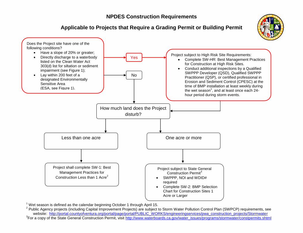
NPDES Construction Requirements
Applicable to Projects that Require a Grading Permit or Building Permit
How much land does the Project disturb?
One acre or more
Project shall complete SW-1: Best Management Practices for
Construction Less than 1 Acre2
Does the Project site have one of the following conditions?
Have a slope of 20% or greater; Directly discharge to a waterbody listed on the Clean Water Act 303(d) list for siltation or sediment impairment (see Figure 1); Lay within 200 feet of a designated Environmentally Sensitive Area (ESA, see Figure 1).
Project subject to State General Construction Permit3
SWPPP, NOI and WDID# required Complete SW-2: BMP Selection Chart for Construction Sites 1 Acre or Larger
Project subject to High Risk Site Requirements: Complete SW-HR: Best Management Practices for Construction at High Risk Sites. Conduct additional inspections by a Qualified SWPPP Developer (QSD), Qualified SWPPP Practitioner (QSP), or certified professional in Erosion and Sediment Control (CPESC) at the time of BMP installation at least weekly during the wet season1, and at least once each 24-hour period during storm events.
No
Yes
Less than one acre
1 Wet season is defined as the calendar beginning October 1 through April 15. 2 Public Agency projects (including Capital Improvement Projects) are subject to Storm Water Pollution Control Plan (SWPCP) requirements, see
website: http://portal.countyofventura.org/portal/page/portal/PUBLIC_WORKS/engineeringservices/pwa_construction_projects/Stormwater 3For a copy of the State General Construction Permit, visit http://www.waterboards.ca.gov/water_issues/programs/stormwater/constpermits.shtml

Stormwater Permit Requirements for Construction Activities Page 1 of 2 Questionnaire revised 04/19/2011
COUNTY OF VENTURA
STORMWATER PERMIT REQUIREMENTS FOR CONSTRUCTION ACTIVITIES
QUESTIONNAIRE The Ventura County Municipal Stormwater Permit requires implementation of an effective combination of Best Management Practices (BMPs) at construction sites in order to prevent erosion and sediment loss, or the discharge of construction wastes to the storm drain system (available at http://onestoppermit.ventura.org/, subpart 4.F of the Los Angeles Regional Water Quality Control Board Permit Order No. 10-0108). Additionally, construction activities causing one acre or more of soil disturbance (or less than one acre but as a part of a larger common area of development or sale) require coverage under the California Statewide General Construction Permit CAS000002, available online at http://www.waterboards.ca.gov/water_issues/programs/stormwater/construction.shtml.
Please place a check mark in all the boxes that apply to project.
Construction activities causing less than 1 acre of soil disturbance: Complete and submit SW-1 (Best Management Practices for Construction Less than 1 Acre) with the
Building Permit application.
Construction activities with soil disturbance of 1 acre or greater: As required by the State Water Resources Control Board (SWRCB) State General Construction Permit
No.CAS000002, the following items must be completed and submitted to the SWRCB: Stormwater Pollution Prevention Plan (SWPPP) Notice of Intent (NOI) SWRCB fee
(Additional information available online at: http://www.waterboards.ca.gov/water_issues/programs/stormwater/construction.shtml)
Complete SW-2 (Best Management Practices for Construction 1 Acre or Greater). Include completed form SW-2 in the prepared site-specific SWPPP and submit with the Building Permit
application and to the Watershed Protection District County Unincorporated Stormwater Program for certification as a Local SWPPP/SW-2. If your project requires a Grading Permit, then submit documentation with Grading Permit application instead.
Construction Activities at High Risk Sites (see map and definition on back): Complete and submit SW-HR (Best Management Practices for Construction at High Risk Sites
worksheet) and SW-1 or Local SWPPP/SW-2 (whichever is applicable as listed above) with the Building Permit application.
Qualified SWPPP Developer (QSD), Qualified SWPPP Practitioner (QSP), or personnel or consultants who are Certified Professionals in Erosion and Sediment Control (CPESC) shall inspect the site:
at the time of BMP installation, at least weekly between October 1 and April 15, and at least once each 24 hour period during a storm event that generates runoff from the site.
Retain records of inspection reports for review by the Building Permit inspectors upon request.
REQUIREMENTS FOR ALL CONSTRUCTION SITES A copy of the required forms (SW-1, Local SWPPP/SW-2, or SW-HR as applicable) must be kept at the
site during construction activities. Implement all required BMPs during construction.
Questionnaire was prepared by: Name: Title: Organization Name: Signature: Date:

Stormwater Permit Requirements for Construction Activities Page 2 of 2 Questionnaire revised 04/19/2011
County of Ventura Stormwater Permit Requirements for Construction Activities
Questionnaire
ADDITIONAL INFORMATION: Documents referenced in this questionnaire area available at http://onestoppermit.ventura.org/.
DEFINITIONS: CONSTRUCTION ACTIVITY includes any construction or demolition activity, clearing, grading, grubbing, or excavation or any other activity that results in a land disturbance. Construction does not include emergency construction activities required to immediately protect public health and safety or routine maintenance activities required to maintain the integrity of structures by performing minor repair and restoration work, maintain original line and grade, hydraulic capacity, or original purpose of the facility. See “ROUTINE MAINTENANCE” definition for further explanation.Where clearing, grading or excavating of underlying soil takes place during a repaving operation, State General Construction Permit Order No. 2009-0009-DWQ (CAS000002) coverage is required if more than one acre is disturbed or the activities are a part of a larger plan.
ROUTINE MAINTENANCE – Routine maintenance projects include, but are not limited to projects conducted to: 1. Maintain the original line and grade, hydraulic capacity, or original purpose of the facility.2. Perform as needed restoration work to preserve the original design grade, integrity and hydraulic capacity of
flood control facilities.3. Includes road shoulder work, re-grading dirt or gravel roadways and shoulders and performing ditch
cleanouts.4. Update existing linesA and facilities to comply with applicable codes, standards, and regulations regardless if
such projects result in increased capacity.5. Repair leaks
Routine maintenance does not include construction of new linesB or facilities resulting from compliance with applicable codes, standards and regulations. Notes:
A Update existing lines includes replacing existing lines with new materials or pipes. B New lines are those that are not associated with existing facilities and are not part of a project to update or replace existing lines.
HIGH RISK SITES: (i) Construction sites on hillsides (on average 20% or greater slope); and (ii) Construction sites that directly discharge1 to a waterbody listed on the CWA § 303 (d) list for siltation or
sediment; or (iii) Construction activities that occur within or directly adjacent2 to an Environmentally Sensitive Area3. Refer
to Figure 1 (Ventura County Environmentally Sensitive Areas) illustrating ESA locations in Ventura County.
1 Directly Discharge - means outflow from a drainage conveyance system that is composed entirely or predominantly of flows from the subject, property, development, subdivision, or industrial facility, and not commingled with the flows from adjacent lands.
2 Directly Adjacent - means situated within 200 feet of the contiguous zone required for the continued maintenance, function, and structural stability of the environmentally sensitive area.
3 Environmentally Sensitive Area (ESA) - means an area “in which plant or animal life or their habitats are either rare or
especially valuable because of their special nature or role in an ecosystem and which would be easily disturbed or degraded by human activities and developments” (Reference: California Public Resources Code § 30107.5). ESAs willinclude Clean Water Act 303d Listed Water Bodies in all reaches that are unimproved, all California Coastal Commission’s Environmentally Sensitive Habitat Areas as delineated on maps in Local Coastal Plans and the Regional Water Quality Control Board’s Basin Plan’s Rare, Threatened or Endangered Species (RARE) and Preservation of Biological Habitats (BIOL) designated waterbodies. The California Department of Fish and Game’s Significant Natural Areas map will be considered for inclusion as the department field verifies the designated locations. Watershed restoration projects will be considered for inclusion as the department field verifies the designated locations.
For information on requirements for Qualified SWPPP Developer (QSD) and Qualified SWPPP Practitioner (QSP), refer to http://www.waterboards.ca.gov/water_issues/programs/stormwater/construction.shtml.
For information on requirements for Certified Professionals in Erosion and Sediment Control (CPESC), refer to http://www.cpesc.net/

DS-251
COUNTY OF VENTURA
STORMWATER PERMIT REQUIREMENTS FOR NEW DEVELOPMENT AND REDEVELOPMENT
QUESTIONNAIRE The Ventura County Municipal Stormwater Permit requires implementation of Post-Construction Stormwater Management Plan (PCSMP) controls for applicable New Development and Redevelopment projects. The Part 4.E “Planning and Land Development Program” of the Permit (Order No. R4-2010-0108) provides detailed requirements on the design, implementation, and maintenance of PCSMP controls (available at http://onestoppermit.ventura.org/).
Please place a check mark in all the boxes that apply to project.
The following questionnaire will determine if the proposed project is subject to Ventura Countywide NPDES Municipal Stormwater Permit Order No. R4-2010-0108, Part 4.E “Planning and Land Development Program” requirements to design, implement, and maintain PCSMP controls. 1. Does this proposed project involve construction of street(s), road(s), highway(s), or freeway adding or creating 10,000
square feet or more of impervious surface area (refer to the Definition on page 3)? Yes, this project shall incorporate USEPA Guidance “Managing Wet Weather with Green Infrastructure: Green
Streets” to the maximum extent practicable. For additional information refer to www.onestoppermit.ventura.org under Surface Water Quality Section’s “Guidelines/Standards”. For submittal requirements, refer to item 8 below.
No, proceed to item 2 below. 2. Is this application for construction of a Single Family Hillside1 Home?
Yes, this project shall include Post-Construction Requirements for Single-Family Hillside Homes. For additional information refer to www.onestoppermit.ventura.org under Surface Water Quality Section’s “Guidelines/Standards”. For submittal requirements, refer to item 8 below.
No, proceed to item 3 below. 3. Is the proposed project located within the County Unincorporated Urban areas?
Yes, proceed to item 4 below. No, this proposed project is not subject to PCSMP controls. No further Action.
4. Is this application for a New Development project involving creation or addition of impervious surface area (refer to
the Definition on page 3)? Yes, proceed to item 5 below. No, proceed to item 6 below.
5. Please check the appropriate box if the proposed New Development project involves any of the following activities:
Yes, New Development project equal to 1 acre or greater of disturbed area and adding more than 10,000 square feet of impervious surface area (refer to the Definition on page 3);
Yes, Industrial park 10,000 square feet or more of surface area; Yes, Commercial strip mall 10,000 square feet or more of impervious surface area (refer to the Definition
page 3);
1 “Hillside” is defined as average slope of 20% or greater.

COUNTY OF VENTURA STORMWATER PERMIT REQUIREMENTS FOR NEW DEVELOPMENT AND REDEVELOPMENT
QUESTIONNAIRE
Stormwater Permit Requirements for New Development and Redevelopment Projects Stormwater Program Questionnaire 02-17-2012
Page 2of 3
Yes, Retail gasoline outlet 5,000 square feet or more of surface area; Yes, Restaurant 5,000 square feet or more of surface area; Yes, Parking lot 5,000 square feet or more of impervious surface area (refer to the Definition on page 3), or with 25 or more parking spaces; Yes, Automotive service facility 5,000 square feet or more of surface area; Yes, a project located in or directly adjacent to, or discharging directly to an Environmentally Sensitive Area2 (ESA), where the development will:
A) Discharge storm water runoff that is likely to impact a sensitive biological species or habitat; andB) Create 2,500 square feet or more of impervious surface area (refer to the Definition on page 3).
No, none of the above; this proposed New Development project is not subject to PCSMP Controls. No further Action.
If you check “Yes” in at least one box above (item 5), proceed to item 8 below for required project submittal information.
6. Is proposed project a Redevelopment and land-disturbing activity (not an interior remodel, roof replacement, or othermaintenance-related activities) of an existing single-family dwelling3 and accessory structures that will result increation, addition, or replacement of 10,000 square feet of impervious surface area (refer to the Definition on page3)?
Yes, the PCSMP controls are required; for project submittal information refer to item 8 No, proceed to item 7 below.
7. Is proposed Redevelopment and land-disturbing activity (not maintenance) project other than existing single-familydwelling that will result in creation, addition, or replacement of 5,000 square feet of impervious surface area (refer tothe Definition on page 3) on already developed site4?
Yes, the PCSMP controls are required; for project submittal information refer to item 8 No, this Redevelopment project is not subject to PCSMP controls. No further Action.
8. If you answered “YES” to questions in items 5, 6, or 7, the proposed project is subject to design, construction, andmaintenance of the PCSMP controls in accordance with the Ventura Countywide Technical Guidance Manual (TGM)for Stormwater Quality Control Measures (available at http://www.vcstormwater.org/technicalguidancemanual.html).The following items shall be included in your application package:
A) Identify proposed PCSMP controls on your site/grading plan,B) Provide the necessary analysis in your Drainage Study to demonstrate that the PCSMP controls will function
as proposed including any applicable stormwater quality design flow or volume calculations for proposedtreatment device(s) using applicable form3 (Appendix E&G of the Technical Guidance Manual), and
C) Submit a Post-Construction Stormwater Management Plan (PCSMP) 5.
2 For complete ESA information, call the Water Quality Engineer at (805) 662-6737. 3 To determine if proposed project meets definition of Redevelopment project, the already developed site shall equal to 1
acre or greater of disturbed area and more than 10,000 ft ² of impervious area shall meet at least one of the criteria listed in items 5 above. For additional information, call the Water Quality Engineer at (805) 662-6737.
4 To determine if proposed project meets definition of Redevelopment project, the already developed site shall meet at least one of the criteria listed in items 5 above. For additional information, call the Water Quality Engineer at (805) 662-6737.
5 County of Ventura PCSMP form is available at www.onestoppermit.ventura.org under Surface Water Quality Section’s“Forms” tab. For additional information, call the Water Quality Engineer at (805) 662-6737.

COUNTY OF VENTURA STORMWATER PERMIT REQUIREMENTS FOR NEW DEVELOPMENT AND REDEVELOPMENT
QUESTIONNAIRE
Stormwater Permit Requirements for New Development and Redevelopment Projects Stormwater Program Questionnaire 02-17-2012 Page 3of 3
Questionnaire was prepared by: Name: Title: Organization Name: Signature: Date: ADDITIONAL INFORMATION: Documents referenced in this questionnaire are available at http://onestoppermit.ventura.org/. DEFINITION: Impervious Surface Area - A hard surface area which either prevents or retards the entry of water into the predevelopment soil mantle. Common impervious surfaces include, but are not limited to, roof tops, walkways, patios, driveways, parking lots or storage areas, impermeable concrete or asphalt paving, gravel roads, packed earthen materials, and oiled macadam or other surfaces which similarly impede the natural infiltration of stormwater. For complete definition refer to the 2011 Ventura Countywide Technical Guidance Manual for Stormwater Quality Control Measures available at http://www.vcstormwater.org/technicalguidancemanual.html. For more information refer to www.onestoppermit.ventura.org under Surface Water Quality Section or call Water Quality Engineer at (805) 662-6737. The copy of the Ventura Countywide Technical Guidance Manual (TGM) for Stormwater Quality Control Measures is available at http://www.vcstormwater.org/technicalguidancemanual.html.
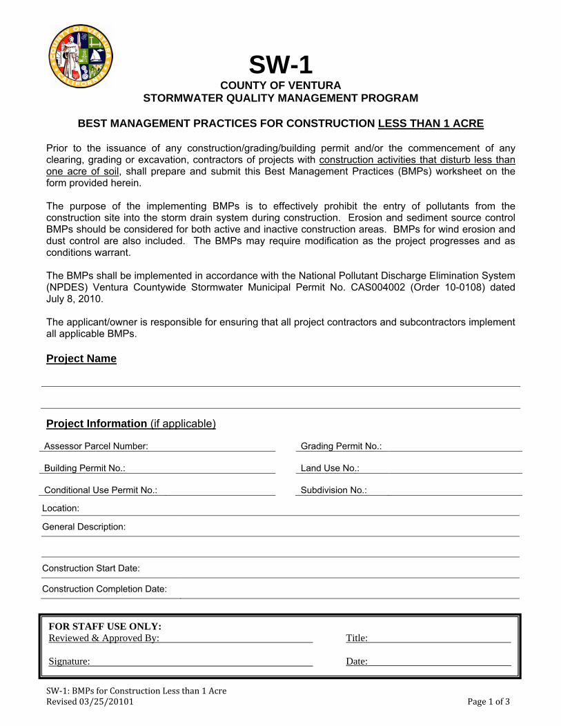
SW‐1: BMPs for Construction Less than 1 Acre Revised 03/25/20101 Page 1 of 3
SW-1 COUNTY OF VENTURA
STORMWATER QUALITY MANAGEMENT PROGRAM
BEST MANAGEMENT PRACTICES FOR CONSTRUCTION LESS THAN 1 ACRE
Prior to the issuance of any construction/grading/building permit and/or the commencement of any clearing, grading or excavation, contractors of projects with construction activities that disturb less than one acre of soil, shall prepare and submit this Best Management Practices (BMPs) worksheet on the form provided herein.
The purpose of the implementing BMPs is to effectively prohibit the entry of pollutants from the construction site into the storm drain system during construction. Erosion and sediment source control BMPs should be considered for both active and inactive construction areas. BMPs for wind erosion and dust control are also included. The BMPs may require modification as the project progresses and as conditions warrant.
The BMPs shall be implemented in accordance with the National Pollutant Discharge Elimination System (NPDES) Ventura Countywide Stormwater Municipal Permit No. CAS004002 (Order 10-0108) dated July 8, 2010.
The applicant/owner is responsible for ensuring that all project contractors and subcontractors implement all applicable BMPs.
Project Name
Project Information (if applicable)
Assessor Parcel Number: Grading Permit No.:
Building Permit No.: Land Use No.:
Conditional Use Permit No.: Subdivision No.:
Location:
General Description:
Construction Start Date:
Construction Completion Date:
FOR STAFF USE ONLY: Reviewed & Approved By: Title:
Signature: Date:

SW-1: BMPs for Construction Less than 1 Acre Revised 03/25/20101 Page 2 of 3
Best Management Practices - BMPs
Complete the following charts. The BMPs listed shall be used unless determined not applicable or inadequate. Additional BMPs may apply. BMP descriptions and details can be downloaded from the California Stormwater Handbooks at www.casqa.org or CalTrans Handbook www.dot.ca.gov/hq/construc/stormwater/manuals.htm.
Table 1. BMPs at Construction Sites Less than 1 Acre
BMPs Selected – Noted by Ref. ID from the California Stormwater BMP Handbooks
Use BMP (If no, state reason)
Yes No
Erosion Control BMPs
EC-1 or SS-1 Scheduling
EC-2 or SS-2
Preservation of Existing Vegetation
Temporary Sediment Control BMPs
SE-1 or SC-1 Silt Fence
SE-8 or SC-8 Sandbag Barrier
Temporary Tracking Control BMPs
TC-1 Stabilized Construction Entrance/Exit
Non-Stormwater Management BMPs
NS-1 Water Conservation Practices
NS-2 Dewatering Operations
Waste Management & Materials Pollution Control BMPs
WM-1 Material Delivery & Storage
WM-3 Stockpile Management
WM-4 Spill Prevention & Control
WM-5 Solid Waste Management
WM-8 Concrete Waste Management
WM-9 Sanitary/Septic Waste Mgmt.
Additional BMPs Selected

SW-1: BMPs for Construction Less than 1 Acre Revised 03/25/20101 Page 3 of 3
Certification
Project Architect/ Engineer of Record, or Authorized Qualified Designee:
As the architect, or engineer of record, or authorized qualified designee, I have selected appropriate BMPs to effectively minimize the negative impacts of this project’s construction activities on storm water quality. The project owner and contractor are aware that the selected BMPs must be installed, monitored, and maintained to ensure their effectiveness. The BMPs not selected for implementation are redundant or deemed not applicable to the proposed construction activity.
Name: Title:
Organization Name:
Signature: Date:
Property Owner/ Owner’s Representative or Designee:
I certify that this document and all attachments were prepared under my direction or supervision in accordance with a system designed to ensure that qualified personnel properly gather and evaluate the information submitted. Based on my inquiry of the person or persons who manage the system or those persons directly responsible for gathering the information, to the best of my knowledge and belief, the information submitted is true, accurate, and complete. I am aware that submitting false and/ or inaccurate information, failing to update the Local SWPPP to reflect current conditions, or failing to properly and/ or adequately implement the Local SWPPP may result in revocation of grading and/ or other permits or other sanctions provided by law.
Name: Title:
Organization Name:
Signature: Date:
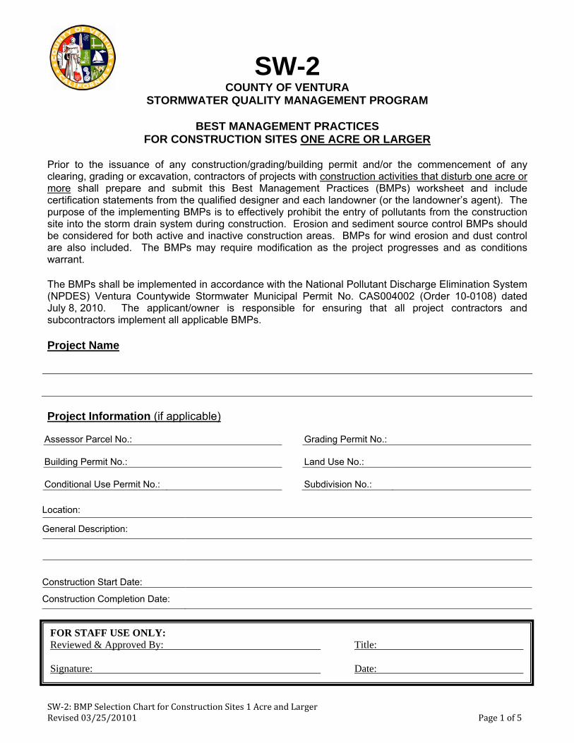
SW‐2: BMP Selection Chart for Construction Sites 1 Acre and Larger Revised 03/25/20101 Page 1 of 5
SW-2 COUNTY OF VENTURA
STORMWATER QUALITY MANAGEMENT PROGRAM
BEST MANAGEMENT PRACTICES FOR CONSTRUCTION SITES ONE ACRE OR LARGER
Prior to the issuance of any construction/grading/building permit and/or the commencement of any clearing, grading or excavation, contractors of projects with construction activities that disturb one acre or more shall prepare and submit this Best Management Practices (BMPs) worksheet and include certification statements from the qualified designer and each landowner (or the landowner’s agent). The purpose of the implementing BMPs is to effectively prohibit the entry of pollutants from the construction site into the storm drain system during construction. Erosion and sediment source control BMPs should be considered for both active and inactive construction areas. BMPs for wind erosion and dust control are also included. The BMPs may require modification as the project progresses and as conditions warrant.
The BMPs shall be implemented in accordance with the National Pollutant Discharge Elimination System (NPDES) Ventura Countywide Stormwater Municipal Permit No. CAS004002 (Order 10-0108) dated July 8, 2010. The applicant/owner is responsible for ensuring that all project contractors and subcontractors implement all applicable BMPs.
Project Name
Project Information (if applicable)
Assessor Parcel No.: Grading Permit No.:
Building Permit No.: Land Use No.:
Conditional Use Permit No.: Subdivision No.:
Location:
General Description:
Construction Start Date:
Construction Completion Date:
FOR STAFF USE ONLY: Reviewed & Approved By: Title:
Signature: Date:

SW-2: BMP Selection Chart for Construction Sites 1 Acre and Larger Revised 03/25/20101 Page 2 of 5
Best Management Practices - BMPs
Complete the following charts. The BMPs listed shall be used unless determined not applicable or inadequate. Additional BMPs may apply based on the effective combinations of the BMPS to prevent erosion and sediment loss, and the discharge of construction wastes. BMP descriptions and details can be downloaded from the California Stormwater Handbooks at www.casqa.org or CalTrans Handbook www.dot.ca.gov/hq/construc/stormwater/manuals.htm.
Table A. Minimum BMPs Required* for Construction Sites 1 acre or Greater
BMPs Selected – Noted by Ref. ID from the California Stormwater BMP Handbooks
Use BMP * (If no, state reason) Yes No
Erosion Control BMPs
EC-1 or SS-1 Scheduling
EC-2 or SS-2
Preservation of Existing Vegetation
EC-3 or SS-3 Hydraulic Mulch
EC-4 or SS-4 Hydroseeding
EC-5 or SS-5 Soil Binders
EC-6 or SS-6 Straw Mulch
EC-7 or SS-7 Geotextiles and Mats
EC-8 or SS-8 Wood Mulching
Temporary Sediment Control BMPs
SE-1 or SC-1 Silt Fence
SE-5 or SC-5 Fiber Rolls
SE-6 or SC-6 Gravel Bag Berm
SE-7 or SC-7 Street Sweeping and/or Vacuum
SE-8 or SC-8 Sandbag Barrier
SE-10 or SC-10 Storm Drain Inlet Protection
Temporary Tracking Control BMPs
TC-1 Stabilized Construction Entrance/Exit

SW-2: BMP Selection Chart for Construction Sites 1 Acre and Larger Revised 03/25/20101 Page 3 of 5
BMPs Selected – Noted by Ref. ID from the California Stormwater BMP Handbooks
Use BMP * (If no, state reason) Yes No
TC-2 Stabilized Construction Roadway
TC-3 Entrance/Exit Tire Wash
Non-Stormwater Management BMPs
NS-1 Water Conservation Practices
NS-2 Dewatering Operations
NS-8 Vehicle and Equipment Washing
NS-9 Vehicle and Equipment Fueling
WE-1 Wind Erosion Controls
Waste Management & Materials Pollution Control BMPs
WM-1 Material Delivery & Storage
WM-3 Stockpile Management
WM-4 Spill Prevention & Control
WM-5 Solid Waste Management
WM-8 Concrete Waste Management
WM-9 Sanitary/Septic Waste Mgmt.
Additional BMPs Selected
Table B. Additional BMPs Required* for Construction Sites 5 acres and Greater
□ Not Applicable (check here for projects between 1 and 5 acres)
BMPs Selected – Noted by Ref. ID from the California Stormwater BMP Handbooks
Use BMP * (If no, state reason) Yes No
Sediment Control BMPs
SE-2 or SC-2 Sediment Basin
SE-4 or SC-4 Check Dam
Tracking Control BMPs
TR-1 or TC-1
Stabilized Construction Entrance/Exit

SW-2: BMP Selection Chart for Construction Sites 1 Acre and Larger Revised 03/25/20101 Page 4 of 5
BMPs Selected – Noted by Ref. ID from the California Stormwater BMP Handbooks
Use BMP * (If no, state reason) Yes No
Non-Stormwater Management BMPs
NS-10 Vehicle and Equipment Maintenance
Waste Management & Materials Pollution Control BMPs
WM-1 Material Delivery and Storage
WM-4 Spill Prevention and Control
WM-8 Concrete Waste Management
WM-9 Sanitary Septic Waste Management
Additional BMPs Selected

SW-2: BMP Selection Chart for Construction Sites 1 Acre and Larger Revised 03/25/20101 Page 5 of 5
Certification
Project Architect/ Engineer of Record, or Authorized Qualified Designee: As the architect, or engineer of record, or authorized qualified designee, I have selected appropriate BMPs to effectively minimize the negative impacts of this project’s construction activities on storm water quality. The project owner and contractor are aware that the selected BMPs must be installed, monitored, and maintained to ensure their effectiveness. The BMPs not selected for implementation are redundant or deemed not applicable to the proposed construction activity. Name: Title: Organization Name: Signature: Date: Property Owner/ Owner’s Representative or Designee: I certify that this document and all attachments were prepared under my direction or supervision in accordance with a system designed to ensure that qualified personnel properly gather and evaluate the information submitted. Based on my inquiry of the person or persons who manage the system or those persons directly responsible for gathering the information, to the best of my knowledge and belief, the information submitted is true, accurate, and complete. I am aware that submitting false and/ or inaccurate information, failing to update the Local SWPPP to reflect current conditions, or failing to properly and/ or adequately implement the Local SWPPP may result in revocation of grading and/ or other permits or other sanctions provided by law. Name: Title: Organization Name: Signature: Date:

SW-HR BMPs for Construction at High Risk Sites Revised 03/25/2010 Page 1 of 6
SW-HR COUNTY OF VENTURA
STORMWATER QUALITY MANAGEMENT PROGRAM
ENHANCED BEST MANAGEMENT PRACTICES FOR CONSTRUCTION AT HIGH RISK SITES
Prior to the issuance of any construction/grading/building permit and/or the commencement of any clearing, grading or excavation, contractors of projects with construction activities at High Risk Sites, shall prepare and submit this Enhanced Best Management Practices (BMPs) worksheet on the form provided herein. High Risk Sites include:
(i) Construction sites on hillsides (average slope 20% or greater); or
(ii) Construction sites that directly discharge1 to a waterbody listed on the CWA § 303 (d) list for siltation or sediment; or
(iii) Construction activities that occur within or directly adjacent2 to an Environmentally Sensitive Areas3 (ESAs). Refer to Figure 1 (Ventura County Environmentally Sensitive Areas) illustrating ESA locations in Ventura County, available at http://onestoppermit.ventura.org/.
1 Directly Discharge - means outflow from a drainage conveyance system that is composed entirely
or predominantly of flows from the subject, property, development, subdivision, or industrial facility, and not commingled with the flows from adjacent lands.
2 Directly Adjacent - means situated within 200 feet of the contiguous zone required for the continued maintenance, function, and structural stability of the environmentally sensitive area.
3 Environmentally Sensitive Area (ESA) - means an area “in which plant or animal life or their habitats are either rare or especially valuable because of their special nature or role in an ecosystem and which would be easily disturbed or degraded by human activities and developments” (Reference: California Public Resources Code § 30107.5). ESAs will include Clean Water Act 303d Listed Water Bodies in all reaches that are unimproved, all California Coastal Commission’s Environmentally Sensitive Habitat Areas as delineated on maps in Local Coastal Plans and Regional Water Quality Control Board’s Basin Plan Rare, Threatened or Endangered Species (RARE) and Preservation of Biological Habitats (BIOL) designated waterbodies. The California Department of Fish and Game’s Significant Natural Areas map will be considered for inclusion as the department field verifies the designated locations. Watershed restoration projects will be considered for inclusion as the department field verifies the designated locations.
The purpose of the implementing BMPs is to effectively prohibit the entry of pollutants from the construction site into the storm drain system during construction. Erosion and sediment source control BMPs should be considered for both active and inactive (previously disturbed) construction areas. BMPs for wind erosion and dust control are also included. The BMPs may require modification as the project progresses and as conditions warrant. The BMPs shall be implemented in accordance with the National Pollutant Discharge Elimination System (NPDES) Ventura Countywide Municipal Stormwater Permit No. CAS004002 (Order 10-0108) dated July 8, 2010. The applicant/owner is responsible for ensuring that all project contractors and subcontractors implement all applicable BMPs.

SW‐HR BMPs for Construction at High Risk Sites Revised 03/25/2010 Page 2 of 6
1. Project Name
2. Project Information (if applicable)
Assessor Parcel Number: Grading Permit No.:
Building Permit No.: Land Use No.:
Conditional Use Permit No.: Subdivision No.:
Location: General Description:
Construction Start Date: Construction Completion Date:
FOR STAFF USE ONLY: Reviewed & Approved By: Title: Signature: Date:

SW-HR BMPs for Construction at High Risk Sites Revised 03/25/2010 Page 3 of 6
3. Enhanced Best Management Practices (BMPs)
Complete the following charts. The BMPs listed shall be used unless determined not applicable or inadequate. Additional BMPs may apply. BMP descriptions and details can be downloaded from the California Stormwater Handbooks at www.casqa.org or CalTrans Handbook www.dot.ca.gov/hq/construc/stormwater/manuals.htm.
Table 1. Enhanced BMPs for Construction at High Risk Sites
BMPs Selected – Noted by Ref. ID from the California Stormwater BMP Handbooks
Use BMP (If no, state reason)
Yes No
Erosion Control BMPs
EC-1 or SS-1 Scheduling
EC-2 or SS-2
Preservation of Existing Vegetation
EC-3 or SS-3 Hydraulic Mulch
EC-4 or SS-4 Hydroseeding
EC-5 or SS-5 Soil Binders
EC-6 or SS-6 Straw Mulch
EC-7 or SS-7 Geotextiles and Mats
EC-8 or SS-8 Wood Mulching
EC-11 or SS-11 Slope Drains
Temporary Sediment Control BMPs
SE-1 or SC-1 Silt Fence
SE-2 or SC-2 Sediment Basin
SE-4 or SC-4 Check Dam
SE-5 or SC-5 Fiber Rolls
SE-6 or SC-6 Gravel Bag Berm
SE-7 or SC-7 Street Sweeping and/or Vacuum
SE-8 or SC-8 Sand Bag Barrier

SW-HR BMPs for Construction at High Risk Sites Revised 03/25/2010 Page 4 of 6
BMPs Selected – Noted by Ref. ID from the California Stormwater BMP Handbooks
Use BMP (If no, state reason)
Yes No
SE-10 or SC-10 Storm Drain Inlet Protection
SE-11 Active Treatment Systems1
Temporary Tracking Control BMPs
TC-1 Stabilized Construction Entrance/Exit
TC-2 Stabilized Construction Roadway
TC-3 Entrance/Exit Tire Wash
Non-Stormwater Management BMPs
NS-1 Water Conservation Practices
NS-2 Dewatering Operations
NS-8 Vehicle and Equipment Washing
NS-9 Vehicle and Equipment Fueling
NS-10 Vehicle and Equipment Maintenance
WE-1 Wind Erosion Controls
Waste Management & Materials Pollution Control BMPs
WM-1 Material Delivery & Storage
WM-3 Stockpile Management
WM-4 Spill Prevention & Control
WM-5 Solid Waste Management
WM-8 Concrete Waste Management
WM-9 Sanitary/Septic Waste Mgmt.
Additional BMPs Selected
1 If appropriate given natural background stormwater runoff and receiving water quality conditions

SW-HR BMPs for Construction at High Risk Sites Revised 03/25/2010 Page 5 of 6
4. Enhanced BMP Inspection Requirements Construction activity projects at high risk sites shall be inspected by the project proponent’s:
(a). Qualified Stormwater Pollution Prevention Plan (SWPPP) Developer*,
(b). Qualified SWPPP Practitioner*, or
(c). Personnel or contractors who are Certified Professionals in Erosion and Sediment Control (CPESC)**
Notes:
* Qualified SWPPP Developer/Practitioner – for more information: e-mail [email protected], call (916) 341-5537, or visit http://www.swrcb.ca.gov/water_issues/programs/stormwater/constpermits.shtml
** Certified Professionals in Erosion and Sediment Control (CPESC) – for more information: email: [email protected], call (828) 655-1600, or visit http://www.cpesc.org/
The inspection frequency for construction activity projects at high risk sites must be:
(i) at the time of BMP installation,
(ii) at least weekly during the wet season, and
(iii) at least once each 24 hour period during a storm event that generates runoff from the site.
The inspection purpose is to identify BMPs that need maintenance to operate effectively, that have failed or could fail to operate as intended. All records of the inspection shall be retained. During the wet season (October 1 through April 15), the area of disturbance shall be limited to the area that can be controlled with an effective combination of erosion and sediment control BMPs. Enhanced sediment controls should be used in combination with erosion controls and should target portions of the site that cannot be effectively controlled by standard erosion controls described above.

SW-HR BMPs for Construction at High Risk Sites Revised 03/25/2010 Page 6 of 6
Certification Project Architect/ Engineer of Record, or Authorized Qualified Designee: As the architect, or engineer of record, or authorized qualified designee, I have selected appropriate BMPs to effectively minimize the negative impacts of this project’s construction activities on storm water quality. The project owner and contractor are aware that the selected BMPs must be installed, monitored, and maintained to ensure their effectiveness. The BMPs not selected for implementation are redundant or deemed not applicable to the proposed construction activity. Name: Title: Organization Name: Signature: Date: Property Owner/ Owner’s Representative or Designee: I certify that this document and all attachments were prepared under my direction or supervision in accordance with a system designed to ensure that qualified personnel properly gather and evaluate the information submitted. Based on my inquiry of the person or persons who manage the system or those persons directly responsible for gathering the information, to the best of my knowledge and belief, the information submitted is true, accurate, and complete. I am aware that submitting false and/ or inaccurate information, failing to update the Local SWPPP to reflect current conditions, or failing to properly and/ or adequately implement the Local SWPPP may result in revocation of grading and/ or other permits or other sanctions provided by law. Name: Title: Organization Name: Signature: Date:

SW-HR BMPs for Construction at High Risk Sites Attachment 1 Revised 03/25/2010 Page 1 of 2
Attachment 1 to SW-HR
Inspection Checklist for Construction Activities at High Risk Sites Qualified Stormwater Pollution Prevention Plan (SWPPP) Developer, Qualified SWPPP Practitioner, or personnel or contractors who are Certified Professionals in Erosion and Sediment Control (CPESC) shall conduct site inspection at the time of BMP installation, at least weekly during the wet season (October 1 through April 15), and at least once each 24 hour period during a storm event that generates runoff from the site using this checklist. Keep a copy of the completed inspection checklist with the project form SW-HR for the “Construction Activities at High Risk Sites” on site. DATE OF INSPECTION: ___________________________________________________ INSPECTION TYPE – check as applicable:
� at the time of BMP installation
� at least weekly during the wet season
� at least once each 24 hour period during a storm event that generates runoff from the site.
Project Name: ___________________________________________________________ Inspector’s Name:________________________________________________________ Inspector - check below as applicable: � Qualified SWPPP Developer � Qualified SWPPP Practitioner � CPESC Weather Conditions during inspection: ______________________________________
Item Compliance
Accomplished YES NO N/A
Date Completed
1 Are enhanced BMPs installed as identified in the project’s SW-HR form?
2 Are installed enhanced BMPs effective?
3 Is the site entrance stabilization adequate?
4 Is equipment/vehicles parked in designated areas and free from significant leaks? Are drip pans present as needed?
5 Are maintenance areas free from stains on the soil?
6 Are all materials stored in bins or covered in plastic and protected from storm water?

SW-HR BMPs for Construction at High Risk Sites Attachment 1 Revised 03/25/2010 Page 2 of 2
Item
Compliance Accomplished
YES NO N/A
Date Completed
7 Is construction waste being disposed of in proper trash containers?
8 Are concrete washout stations present and being utilized and maintained?
9 Is fugitive dust being controlled and water being used as needed?
10 Are catch basins, drainage channels, drain inlets/outlets being protected?
Comments:
I certify under penalty of law that this inspection is true, and I or a qualified assigned person has performed the required inspection as required. ______________________________ ____________________________ Inspector Name Inspector Signature Date _______________