design and experiment of laser photogrammetric instrument ...€¦ · design and experiment of...
TRANSCRIPT
Design and Experiment of Laser Photogrammetric Instrument for Measuring
Forest
YANG Liyan, FENG Zhongke, FAN Guangpeng, Li Haiyue
(Beijing Forestry University, Beijing 100083, China)
Abstract: To solve the shortcomings that non-intelligent, non-integrated and low efficiency of traditional method
of measuring DBH, tree height and forest stand spatial structure parameters. This paper designed a laser
photogrammetric instrument for measuring forest based on the principle of photogrammetry, image processing
technology, sensor technology and forest measurement. The instrument composed of CCD sensor, laser, LED
flashlight, self-developed PDA and shell. There were three modular procedures which were compiled in the Java
language and developed in Android Studio 2.2 systems development environment. The three modules are DBH
measurements, tree height measurements and forest stand spatial structure parameters measurement. These three
functions are achieved by obtaining parameters such as dip angle, azimuth and image information. The
experiment of measuring DBH (diameter at breast height), tree height with 21 trees as samples and measuring
forest stand spatial structure parameters with 15 reference trees in a plot as samples. Compared with the traditional
measurement method, The mean value of the absolute value of the relative error of the DBH measurement was
2.55%, the tree height was 2.82%, the uniform angle index was 2.50%, the dominance was 2.86% and the
measurement of the mingling is consistent with the traditional measurement method. The measurement accuracy
of the instrument can meet the requirements of forestry survey. The method of using the laser photogrammetric
instrument for measuring forest to measure the forest stand spatial structure parameters can be done requires only
one person. Compared with the traditional measurement method, this method saves 1 times of labor and 31% of
the working time. The instrument has a good prospect in the field of forestry basic investigation and forest stand
spatial structure.
Key words:laser photogrammetric instrument for measuring forest; photogrammetry; tree height; DBH; forest
stand spatial structure; Android system
Introduction
The diameter at 1.3m above the root neck is
called the chest height diameter, which is abbreviated
as breast diameter [1]. The length of the tree neck or
ground to the top of the trunk is called the tree height.
The measurement of DBH and tree height is an
important basis for evaluating site quality and forest
growth. There are many kinds of tools for measuring
the diameter. Commonly used are calipers, diameter
tape measures and hook gauges [2]. The height of the
tree is generally measured by a height sensor. There
are many kinds of height measuring instruments, but
the principle of height measurement is relatively
simple, such as the Bleus height sensor and ultrasonic
height sensor [3-5]. The spatial structure of forest
stands is an important feature that reflects the spatial
location of forest trees within forest stands, and is a
visual reflection of the distribution pattern and
arrangement of forest trees in space[6-10]. At present,
the spatial structure parameters of forest stand mainly
include the angle scale, size ratio and mixed degree
[11-15]. In the calculation of the angular scale, the
relative positions of the central tree and the four
nearest trees need to be measured. The commonly
used methods mainly include the direct judgment of
the angle determiner and the total station instrument to
measure the coordinates of each tree. However, there
are manual interpretation errors for the two methods.
The Yamato Total Station is expensive and
cumbersome. Due to the uncertainty of the landform
of the forest, the surveyors could not reach certain
lands or they could not carry out manual
measurements on the ground. In order to overcome
the influence of these unfavorable factors, non-contact
measurement methods have received attention.

With the advent of the era of information
intelligence, the use of more integrated, intelligent,
and accurate forestry survey and observation
equipment has become the mainstream of forest
resources survey [16]. Feng Zhongke et al [17-22]
developed 3D electronic angle gauges, stylized
electronic theodolites, total tree surveying instruments,
remote photography superstations, and handheld tree
measurement smart stations to measure the DBH and
tree height. Huang Xiaodong et al. [23] developed a
multi-functional portable micro-super station to
measure breast diameter and tree height. Hou Xinxin
et al. [24] proposed a breast diameter measurement
method based on a single charge coupled device
image sensor CCD camera and a theodolite. Zhao
Fang et al. [25] used a total station to measure the tree
height and volume, and verified the accuracy. Qiu
Haoxuan et al [26] developed a forest intelligence
mapping recorder that can measure the DBH and tree
height. Xu Weiheng et al [27,28] developed a
multi-functional electronic tree testing gun to achieve
tree height measurement, diameter measurement at
any height, and spatial structure parameter
measurement of forest stands. In recent years,
domestically developed instruments have basically
solved problems such as single device function and
poor portability, but there are still problems such as
poor accuracy, low efficiency, and high equipment
cost.
In view of the above situation, this study is aimed
at the actual needs of forestry survey important basic
factors and the determination of spatial structure
parameters of forest stands, using CCD cameras, tilt
sensors, electronic compasses, laser pens, etc., based
on the principle of photogrammetry and the principles
of tree-measurement, from android system embeds the
procedures for automatically calculating the
parameters such as DBH, tree height, and spatial
structure parameters of forest stands, and designs a
one-stop photo tree measuring instrument—laser
photometer and tree measuring instrument to realize
the measurement of breast diameter and tree height,
angle scale measurement, size ratio measurement,
mixing degree measurement and other functions.
1 laser photogrammetric instrument for
measuring forest structure
1.1 Hardware composition
The laser photogrammetric instrument for
measuring forest hardware used the handheld PDAs
and heads independently developed by the Beijing
Key Laboratory of CCD sensor, laser, LED flashlight,
self-developed PDA and shell. as shown in Figure 1.
CCD sensor selection telescopic fixed-focus optical
lens, back-illuminated CMOS (Exmor R CMOS)
sensor, 6 groups of 7 (4 aspherical lens / AA lens
included) lens structure, F1.8-F4.9 maximum aperture ,
LED fill light, Micro SD/Micro SDHC memory card,
NP-BN/NP-BN1 lithium battery, 200 battery life. The
laser uses an optical lens composed of high-quality
acrylic lenses, a 5mW power die, and a high-quality
acrylic lens that projects a visible laser beam. The
handheld PDA is highly integrated and designed with
aluminum alloy housings such as CPU, GPU, RAM,
ROM, gyroscope, gravity sensor, WiFi chip,
electronic compass, GPS chip, color touch display,
and power supply. The overall hardware of the
instrument hardware is shown in Figure 2.
Fig.1 Photo of laser photogrammetric instrument
CPU
GPU
Power
supply
Gyro
Gravity sensor
WiFi chip
GPS chip
Electronic compass
Touch screen
ROM
RAM
PDA
PTZ
CCD
Light Source pen
Laser
Fig.2 Framework of hardware

The handheld PDA module uses Qualcomm
Snapdragon 617 processor (MSM8952), eight-core
A53, and 1.5GHz core frequency to interpret
instructions and process data. The GPU uses Adreno
530, which processes 64 bits and handles the
acquisition of image information. RAM uses
dual-channel LPDDR4X, capacity 2GB, maximum
frequency 1866MHz; HSPA+, CDMA, LTE baseband;
ROM uses C8051F410 on-chip flash memory design,
16GB, speed class Class 10, maximum sustained
speed 80m/s; 5.5-inch display, resolution 1920x1080,
pixel density 401PPI. The gyroscope and electronic
compass employ a three-axis gyro sensor L3G4200D
and a three-axis magnetic field sensor LSM303DLH
for measuring the magnetic azimuth of the instrument;
Gravity sensor uses triaxial acceleration sensor
LIS331DLH, used to measure equipment tilt angle,
WiFi chip uses dual-frequency MT6625, supports
802.11a/b/g/n wireless protocol sensor LIS331DLH,
used to connect CCD lens, control shooting and
transfer images; The GNSS chip supports GPS and
Beidou Double Star Positioning System Module L218
for calibrating the sample location. The light source
pen uses a zoom wide-angle miniature flashlight, LED
light, and 18650 lithium battery for light source
supply in dim conditions to increase the visibility of
the edges of the trees.
1.2 Software design
PDA embedded software is compiled in the
Android Studio 2.2 development environment using
the Java language, using a modular structure design,
respectively, breast diameter measurement module,
tree height measurement module and forest spatial
structure parameter measurement module. Figure 3a is
the software main program flow chart, the user
chooses to enter different functional modules
according to the actual measurement work
requirements. Figures 3b~3d are the flow chart of the
three main measurement modules. The measurement
result data are read and written through the SQLite
database and can be transmitted via the USB interface.
Main program
System initialization
Function selection
DBH
measureme
nt module
Tree height
measureme
nt module
Forest spatial
structure parameter
measurement module
(a)Main program

Star
initialization
Turn on CCD and
connect WiFi
normal photography to
obtain image at breast
diameter
Transfer to PAD
Image processing
Extract the left and right
points of the DBH
Turn on the laser
Calculate DBH
End
Star
initialization
Turn on CCD and
connect WiFi
normal photography to
obtain image at breast
diameter
Transfer to PAD
Image processing and
calculating instrument
to standing distance
Get laser point
Turn on the laser
Collecting the inclination
of the root of the tree
End
Collect the tip of the tree
Calculate tree height
(b)Breast diameter measurement program (c)Tree height measurement program
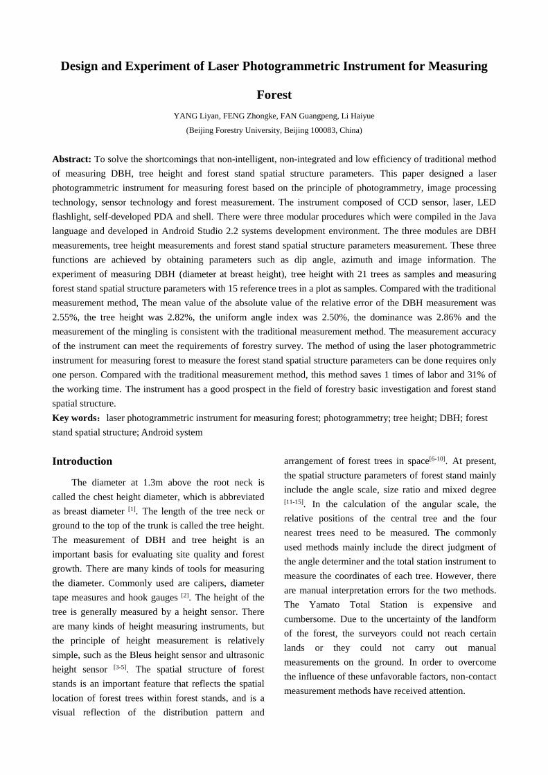
Star
initialization
Turn on CCD and connect WiFi
Input the sample location information
Call breast diameter
measurement module to
measure breast diameter
Select the center tree and the
adjacent 4-6 trees
Turn on the laser
Measurement results are
stored in the SQLite
database
Select the 4 nearest trees to the center
tree and calculate the size ratio, angle
scale and mingling angle
Manually determine the
similarities and differences
between the tree types of the
adjacent tree and the center tree,
the same record is 1 and the
different records is 0
Record the shooting
azimuth angle to the
stand distance
The number of measured trees
is greater than or equal to 4?
Storing data
Y
N
(d)Forest Stand Spatial Structure Parameter Measurement Procedure
Fig.3 Flowcharts of main system and 3 function modules
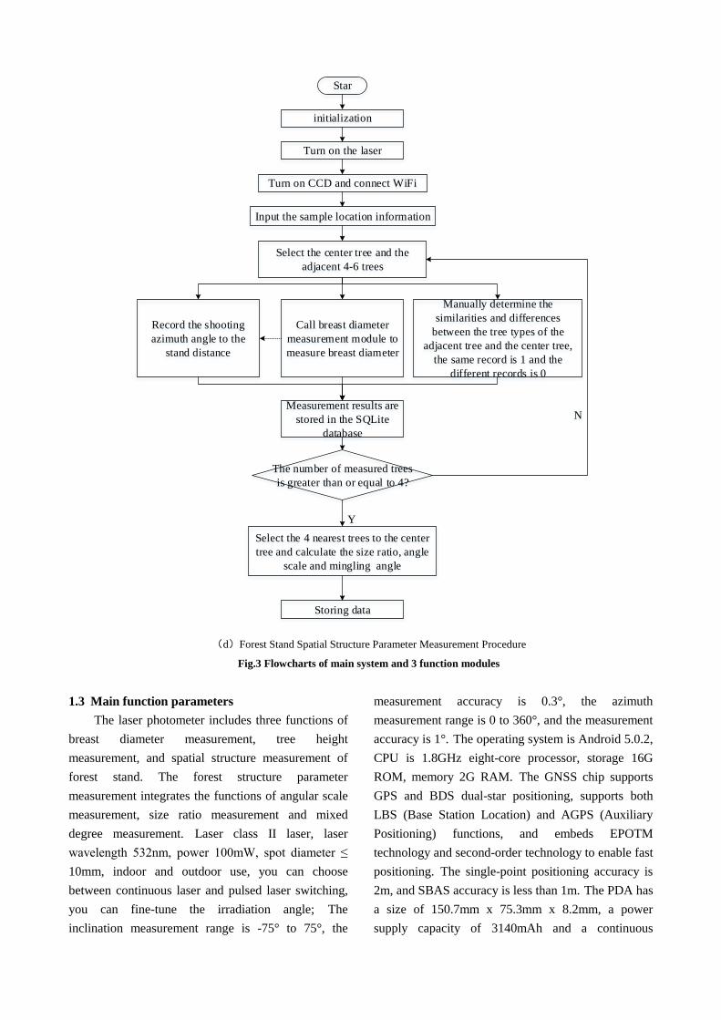
1.3 Main function parameters
The laser photometer includes three functions of
breast diameter measurement, tree height
measurement, and spatial structure measurement of
forest stand. The forest structure parameter
measurement integrates the functions of angular scale
measurement, size ratio measurement and mixed
degree measurement. Laser class II laser, laser
wavelength 532nm, power 100mW, spot diameter ≤
10mm, indoor and outdoor use, you can choose
between continuous laser and pulsed laser switching,
you can fine-tune the irradiation angle; The
inclination measurement range is -75° to 75°, the
measurement accuracy is 0.3°, the azimuth
measurement range is 0 to 360°, and the measurement
accuracy is 1°. The operating system is Android 5.0.2,
CPU is 1.8GHz eight-core processor, storage 16G
ROM, memory 2G RAM. The GNSS chip supports
GPS and BDS dual-star positioning, supports both
LBS (Base Station Location) and AGPS (Auxiliary
Positioning) functions, and embeds EPOTM
technology and second-order technology to enable fast
positioning. The single-point positioning accuracy is
2m, and SBAS accuracy is less than 1m. The PDA has
a size of 150.7mm x 75.3mm x 8.2mm, a power
supply capacity of 3140mAh and a continuous

operating time of 8h. CCD sensitivity of ISO
160-6400, WIFI wireless transmission support
802.11b/g/n, effective pixels 2020 million, exposure
compensation ± 3EV (1/3EV steps), the highest image
resolution 5472 pixels × 3648 pixels, support for live
view For obtaining image information, the battery's
continuous working time is 5h. The head size is
160mm x 78mm x 70mm. The variable light source
pen supports astigmatism and strong light, power is
3-10W, range is over 200m, continuous exposure time
is more than 2h.
2 Laser photometer measuring principle
2.1 Laser photographic tree test
There are two kinds of systematic errors in the
measurement of laser photometers, which are the
optical distortion of the CCD camera lens and the
error between the CCD main optical axis and the main
optical axis of the laser. In order to improve the
measurement accuracy, two types of systematic errors
need to be eliminated or decrease [16].
A direct linear transformation (DLT) model was
used to solve the internal orientation elements and
distortion parameters of the CCD camera. The specific
calibration method is described in [29]. In order to
reduce the offset error between the CCD main optical
axis and the laser main optical axis, a checkerboard
checker board of 60cm×100cm is manufactured. The
checkerboard size is 10cm×10cm. The CCD camera
and the laser are turned on and generated in the
real-time image screen. Main point centered cross
orthogonal line, first fine-tune the laser from left to
right so that the laser spot coincides with the vertical
line of the crosshair. A laser photometer was placed
and the calibration board was placed at positions N
and F about 3m and 10m away from the instrument,
and the image coordinates of the laser spot in the
image were read sequentially. The formula for
calculating the angle between the main optical axis of
the laser and the main optical axis of the CCD is:
2 2 2 2
2 2
tan
( ) ( )
N N N F F F
F N
ab
b a b a
m u v m u v
L L
DLm
f u u v v
(1)
N Fm m、 ——Photo scale factor for near and far
shooting
( , )N Nu v 、( , )F Fu v ——The image coordinates of
the laser point shot at the near and far points
N FL L、 ——The distance between the lens and
the calibration board when the laser point is shot at the
near point and far point
L——CCD Lens to calibration board distance
f——CCD Lens focal length
abD ——Arbitrary selection of a point and b point
in the checkerboard
( , )a au v 、 ( , )b bu v ——The image coordinates of
point a and point b in the image
m——Photo scale factor
If "+", the laser is fine-tuned upwards; otherwise,
the laser is fine-tuned downwards. After several
adjustments, it is close to 0, that is, the main optical
axis of the laser is parallel to the main optical axis of
the CCD, and the calibration is completed. The
distance K between the CCD main optical axis and the
laser main optical axis of the last calibration is used as
the instrument constant and is embedded in the
software side together with the CCD calibration
parameters. The formula for K is
2 2 2 21
2N N N F F FK m u v m u v (2)
2.2 Breast diameter measurement
From the image point distance from the laser
point to the main point of the image and the
corresponding object distance K, the image scale
factor m can be calculated. Extract the image
coordinates on the left and right side of the DBH in
the image and calculate the image distance of the

DBH. According to the principle of single
photogrammetry, the vertical diameter of the tree is
calculated.
2 2
2 2
( ) ( )R L R L
l l
D m u u v v
Km
u v
(3)
D——Breast diameter
( , )L Lu v 、 ( , )R Ru v ——The image coordinates
of the left and right breast diameter
( , )l lu v ——The image coordinates of the laser
spot
Fig.4 Interface of DBH measurement
2.3 Tree Height Measurement
The height of the tree is mainly measured by
using a single photogrammetry principle and
trigonometric function principle. The tree height
measurement method is shown in Figure 5. It is
similar to the breast diameter measurement method,
and obtains the image scale factor m. According to the
CCD focal length f and the angle of inclination of the
photographing photograph, the horizontal distance d
from the photographing center to the single wood is
calculated, and the inclination angle α of the
instrument aiming at the tree root and the inclination
angle of the aiming tree top are obtained. β, calculate
tall tree height H.
(tan tan )
cos
H d
d mf
(4)
Fig.5 Principle diagram of tree height measurement
Fig.6 Interface of tree height measurement
2.4 Forest Spatial Structure Parameters
Measurement
Forest spatial structure parameters reflect the
degree of competition, size differences, and horizontal
distribution patterns among trees. Among them, the
angular scale reflects the evenness of the distribution
of trees in the forest. The ratio of size to size reflects
the dominance of the tree growth distribution, and the
degree of mixture reflects the degree of spatial
isolation between different tree species [30]. The
significance of the corresponding value of the mixture
degree, size ratio, and angle scale is shown in Fig. 7.

零度混交 弱度混交 中度混交 强度混交 极强度混交
优势 亚优势 中庸 劣势 绝对劣势
绝对均匀 均匀 随机 不均匀 团状
混交度
代表两个树种
角尺度:
α:相邻木夹角
α0:标准角
大小比数
代表不同大小
:
:
0.00 0.25 0.50 0.75 1.00参数取值
α α0α<α0 α<α0
α<α0
α>α0 α<α0
Fig.7 The sketch map of mingling, dominance and uniform
angle index
The laser photometer can measure the spatial
structure parameters of the forest in a one-stop mode.
The instrument can automatically calculate and save
the values of angle scale, size ratio, and mixed degree.
In the specific measurement, the center tree to be
measured and the four nearest neighbor trees are
determined. The laser is aimed at the center tree T0 to
take pictures, and the diameter DB is automatically
calculated according to the breast diameter
measurement principle, and the inclination and
azimuth angle are obtained through the instrument. It
is similar to the method for measuring the center tree
T0. The adjacent tree Ti is measured in a clockwise
order, and at the same time, it is manually interpreted
whether the adjacent tree and the center tree are the
same tree species. The instrument can automatically
calculate the angle scale, size ratio, and blending
degree according to the above acquisition parameters
and display the result on the screen, and save it to the
SQLite database at any time for easy viewing and
export.
Fig.8 Uniform angle index measuring principle
P is the station; T0 is the center tree; T1~T4 are
the four trees closest to the center tree; δ is the
inclination angle; γ is the azimuth angle; and is the
angle between the center tree and the nearest four
trees.
The calculation formula for the coordinates of the
central tree and the four adjacent trees is
( cos /2)cos
( cos /2)sin
x X m f Di P i i i i
y Y m f Di P i i i i
(5)
(i=0,1,2,3,4)
,i ix y ——Plane coordinates of the ith tree
,P PX Y ——Position the coordinates of instrument
point P
im ——Scale factor for measuring the ith tree
i ——The inclination of the i-th tree
i ——The azimuth of the i-th tree
iD ——The breast diameter of the i-th tree
According to the coordinates of the center tree and
the neighboring tree, the angle between the i-th tree
and the i+1 tree is obtained. The formula is
2 20, 0 0
2 20, 1 1 0 1 0
2 2, 1 1 1
2 2 20, 0, 1 , 1
0, 0, 1
( ) ( )
( ) ( )
( ) ( )
arccos( )2
i ii
i i i
i ii i i i
i i i i
i
i i
S x x y y
S x x y y
S x x y y
S S S
S S
(6)
i=1,2,3;When i=4, 3
4
1
360 i
i
S——The distance between each tree i ——The
angle between the i-th tree and the i+1 tree
4
1
1
4i
i
W z
(7)
1 the i-th is smaller than
the s tan dard angle )
0 others)
iz
o
,(
72
,(
(8)
(i=1,2,3,4)
The size ratio is calculated as Blending formula is
4
1
1
4i
i
U k
(9)

0 The DBH of the i-th adjacent tree is smaller
than the DBH of the central tree
others
ik
,(
)
1,( )
(10)
(i=1,2,3,4)
4
1
1
4i
i
M v
(11)
The i-th adjacent tree is the
same as the central tree
ohters
iv
0,(
)
1,( )
(12)
(i=1,2,3,4)
3 experimental results and analysis
3.1 DBH and tree height measurements test
To verify the breast diameter, height measurement
function, and measurement accuracy of the laser
photometer, an experiment was conducted at the
Jiufeng National Forest Park in Bei’anhe Township,
Haidian District, Beijing. The experiment selected
trees in different forest conditions to test the
measurement function of the forest. 21 trees were
selected as measurement samples, including 7 trees
such as poplar, Chinese pine and Robinia. It uses the
breast diameter measured by the DBH as the true
diameter of the DBH, and the tree height measured by
the total station as the true value of the tree height.
The DBH measured by the laser photometer and the
tree height are compared with the true values. After
calculation, the average absolute values of the relative
error of DBH and tree height were 2.55% and 2.82%,
respectively. The results of the measurement are
shown in Table 1.
Tab.1 Result of DBH and tree height measurement
Tree species
DBH
ruler
measue
DBH
/cm
laser
photogrammetric
instrument for
measuring forest
measure DBH /cm
absolute
relative error
/%
Total Station
measure tree
height /m
photogrammetric
instrument for
measuring forest
measure tree height
/m
absolute
relative error
/%
poplar 18.6 19.1 2.69 22.6 23.2 2.65
poplar 29.5 29.1 1.36 30.5 29.8 2.30
poplar 13.4 13.7 2.24 17.9 18.3 2.23
chinese pine 17.7 17.4 1.69 9.1 8.8 3.30
chinese pine 21.5 20.9 2.79 14.2 14.8 4.23
chinese pine 28.4 28.9 1.76 12.1 11.7 3.31
locust 16.3 15.7 3.68 8.2 8.5 3.66
locust 17.1 17.6 2.92 7.6 7.9 3.95
locust 16.8 16.4 2.38 8.3 8.0 3.61
oak 22.1 22.6 2.26 10.5 10.8 2.86
oak 19.7 19.3 2.03 9.8 9.9 1.02
oak 18.5 19.1 3.24 11.3 11.5 1.77
acer truncatum 15.2 15.6 2.63 8.5 8.3 2.35
acer truncatum 13.1 13.4 2.29 7.8 7.5 3.85
acer truncatum 15.3 14.9 2.61 9.4 9.6 2.13
orientalis 12.1 12.4 2.48 6.8 7.0 2.94
orientalis 10.3 10.8 4.85 7.5 7.2 4.00
orientalis 12.6 13.0 3.17 7.3 7.5 2.74
broussonetia
papyrifera 20.4 20.1 1.47 8.2 8.4 2.44
broussonetia
papyrifera 15.6 16.2 3.85 7.4 7.3 1.35
broussonetia
papyrifera 17.3 17.5 1.16 7.6 7.8 2.63
Mean 17.69 17.80 2.55 11.08 11.13 2.82
3.2 Forest stand spatial structure measurement
test
To verify the spatial structure parameter
measurement function and measurement accuracy of
the laser photometer and tree tester, a sample plot was
selected and tested in the Jiufeng National Forest Park
in Bei’anhe Township, Haidian District, Beijing.
Fifteen central trees were selected in the plot, and one
operator measured the selected central tree using a
laser photometer, and two operators retested using the
traditional measurement method. When using the
traditional measurement method, the angular scale
measurement uses a horn to perform direct
interpretation, the size-ratio measurement uses a
breast diameter ruler to measure and read one by one,
the mixed degree measurement uses a direct
interpretation method, and the interpretation result
uses a paper record. Comparing the results of the two
methods, as shown in Table 2, the results show that
the absolute values of the absolute relative error of the
angular scale and size ratio measurement are 2.50%
and 2.86%, respectively, and the mixed degree
measurement results are the same. That is, the
absolute value of the relative error of the spatial
structure parameters of the three forest stands does not
exceed 3%, which can meet the measurement
accuracy requirements.
Tab.2 Result of forest stand spatial structure measurement
Observation point
No.
laser photogrammetric instrument for measuring
forest Observation method Traditional measurement
Angular scale Size ratio Mixed degree Angular
scale
Size
ratio
Mixed
degree
1 0.50 0.50 0.25 0.50 0.50 0.25
2 0.75 0.50 0.25 0.75 0.50 0.25
3 0.75 0.75 0.00 0.75 0.75 0.00
4 0.50 0.50 0.25 0.50 0.50 0.25
5 0.75 1.00 0.50 0.75 1.00 0.50
6 1.00 0.50 0.25 0.75 0.50 0.25
7 0.75 0.50 0.25 0.75 0.50 0.25
8 0.50 0.75 0.25 0.50 0.75 0.25
9 0.50 0.50 0.00 0.50 0.25 0.00
10 0.75 1.00 0.00 0.75 1.00 0.00
11 0.75 0.50 0.25 0.75 0.50 0.25
12 0.50 0.50 0.25 0.50 0.50 0.25
13 0.25 0.50 0.25 0.50 0.50 0.25
14 1.00 0.25 0.50 1.00 0.25 0.50
15 0.75 0.50 0.00 1.00 0.50 0.00
Mean 0.67 0.58 0.22 0.65 0.57 0.22
Relative error
absolute value /% 2.50 2.86 0.00
4 Conclusion
(1) A laser photometer measuring
instrument composed of CCD sensor, laser, LED
flashlight, self-developed PDA and shell. According
to the principle of photogrammetry and principle of
tree-measurement, using image processing technology
and Java development technology, three functions of

breast diameter measurement, tree height
measurement and spatial structure parameter
measurement of forest stand were achieved. The
spatial structure parameter measurement function of
forest stands achieves one-stop measurement of angle
scale, size ratio, and mixed degree. The function and
accuracy of laser photometer logging instrument
carried out in the Qifeng National Forest Park in
Bei’anhe Township, Haidian District, Beijing, The
results show: The average absolute value of the
relative diameter of breast diameter measurement is
2.55%, the average absolute value of the relative
height of the tree height measurement is 2.82%, the
average value of the absolute value of the angular
scale measurement relative error is 2.50%, and the
relative error of the absolute value of the size ratio
measurement is The average value is 2.86%,the mixed
measurement results are the same as traditional
measurement methods and can meet the accuracy
requirements of forestry surveys.
(2) The laser photometer was developed to achieve
paperless automatic measurement. The data can be
stored and exported, reducing the workload of the
internal processing and lowering the cost. In addition,
the instrument is a non-contact measurement during
operation and can be measured. Compared with the
laser distance measurement type instrument, problems
such as weak return signals due to the unevenness of
the bark during the measurement of the laser distance
meter or deviations of the return signal are avoided.
Therefore, the instrument has a good application
prospect in the field of basic investigation of forestry
and related fields of spatial structure parameter
measurement of forest stands.
References
1 Meng Xianyu. Tree surveying[M]. 3rd edition. Beijing:
China Forestry Publishing House, 2008.
2 Sun Xiurong, Guan Chengku. Discussion on the Determi
nation of Fallen Wood[J]. Industry & Technology Foru
m, 2011, 10(21): 76.
3 Xu Weiheng, FENG Zhongke, SU Zhifang, et al. Devel
opment and experiment of handheld digitalized and mu
lti-functional forest measurement gun[J]. Transactions of
the CSAE, 2013, 29(3): 90-99. (in Chinese).
4 Zhou Keyu. Research and implementation of intelligent t
ree-measurement system based on Android[D]. Hangzho
u: Zhejiang Agriculture and Forestry University, 2015.
5 Feng Zhongke, ZHAO Yingkun, DENG Xiangrui, et al.
Measurement and precision analysis of tree height by
3D forward intersection[J]. Journal of Beijing Forestry
University, 2007, 29(Supp. 2): 36-39. (in Chinese)
6 Hui Gangying. Studies on the application of stand spatia
l structure parameters based on the relationship of neig
hborhood trees[J]. Journal of Beijing Forestry Universit
y, 2013, 35(4): 1-8. (in Chinese)
7 Hu Yanbo, HUI Gangying. How to describe the crowdi
ng degree of trees based on the relationship of neighb
oring trees[J]. Journal of Beijing Forestry University, 2
015, 37(9): 1-8. (in Chinese)
8 Gong Zhiwen, KANG Xingang, GU Li, et al. Research
methods on natural forest stand structure: a review[J].
Journal of Zhejiang Forestry College, 2009, 26(3): 434-
443. (in Chinese)
9 Jiang Xian, ZHANG Huaiqing, HE Shanshan, et al. A s
tudy on design of stand visual simulation system[J]. Fo
rest Research, 2009, 22(4): 597-602. (in Chinese)
10 Xu Hai. Visualization of Natural Korean Pine Broadlea
f Forest[D]. Beijing: Chinese Academy of Forestry, 20
07.
11 Hui Gangying, GADOW K V, HU Yanbo. The optimu
m standard angle of the uniform angle index[J]. Forest
Research, 2004, 17(6): 687-692. (in Chinese)
12 Liao Caixia, WU Yao, YI Deping, et al. Study of fore
st stand spatial structure[J]. Forestry Science and Techn
ology Information, 2007, 39(2): 40-41. (in Chinese)
13 Zhang Huiru, WU Jicheng, YANG Hongbo, et al. Spat
ial structure of mixed larch-spruce-fir stands[J]. Journal
of Zhejiang Forestry College, 2009, 26(3): 319-325. (i
n Chinese)
14 Gong Zhiwen, KANG Xingang, GU Li, et al. Spatial
pattern dynamics of forest succession in spruce-fir mix
ed stand in Changbai Mountain, northeast China[J]. Jou
rnal of Northeast Forestry University, 2010, 38(1): 44-
46. (in Chinese)
15 Hui Gangying, ZHAO Xiuhai, ZHAO Zhonghua, et al.
Evaluating tree species spatial diversity based on neig
hborhood relationships[J]. Forest Science, 2011, 57(4):
292-300.
16 Huang Xiaodong,FENG Zhongke. Obtainment of samp
le tree`s DBH based on digital camera[J/OL]. Transacti
ons of the Chinese Society for Agricultural Machinery,
2015, 46(9): 266-272. (in Chinese)
17 Feng Zhongke, Yang Liyan. A Method for Measuring
the Diameter of a Fixed Angle Ranging Tree: China, 1
03471551[P]. 2017-02-15.
18 Qiu Zixuan, FENG Zhongke, LU Jing, et al. Develop
ment and experiment of forest telescope intelligent den
drometer[J/OL]. Transactions of the Chinese Society for
Agricultural Machinery, 2017, 48(11): 1-9. (in Chines
e)
19 He Cheng, HONG Xiafang, LIU Kezhen, et al. An im
proved technique for non-destructive measurement of th
e stem volume of standing wood[J]. Southern Forests,
2016, 78(1): 53-60.
20 Gao Xiang, FENG Zhongke, WANG Zhichao, et al. St
udy on stem form index based on non-destructive preci
sion measurement through electronic theodolite[J]. Tran
sactions of the Chinese Society for Agricultural Machi
nery, 2015, 46(1): 299-305. (in Chinese)
21 Cao Zhong, GONG Yicheng, FENG Zhongke, et al. Er
ror analysis on standing tree volume measurement by
using electronic theodolites[J/OL]. Transactions of the
Chinese Society for Agricultural Machinery, 2015, 46
(1): 292-298. (in Chinese)
22 Wang Zhichao, FENG Zhongke, YAN Fei, et al. Integ
rated indoor and field forest measurement by using tot
al station[J]. Journal of Northwest Forestry University,
2013, 28(6): 134-138. (in Chinese)
23 Huang Xiaodong, FENG Zhongke, JIE Mingxing, et al.
Developing and accuracy analysis of portable device f
or automatically measuring diameter at breast height an
d tree height[J]. Transactions of the CSAE, 2015, 31(1
8): 92-99. (in Chinese)
24 Hou Xinxin, TAN Yuesheng, QIAN Hua, et al. DBH
measurement method based on tree images taken by si
ngle-CCD camera mounted on theodolite[J]. Application
Research of Computers, 2014, 31(4): 1225-1228. (in
Chinese)
25 Zhao Fang, FENG Zhongke, GAO Xiang, et al. Measu
re method of tree height and volume using total statio
n under canopy cover condition[J]. Transactions of the
CSAE, 2014, 30(2): 182-190. (in Chinese)
26 Qiu Zixuan, FENG Zhongke, JIANG Junzhiwei, et al.
Design and experiment of forest intelligent surveying a
nd mapping instrument[J/OL]. Transactions of the Chin
ese Society for Agricultural Machinery, 2017, 48(5): 1
79-187. (in Chinese)
27 Xu Weiheng. Development and functional testing of a
hand-held supertree survey meter[D]. Beijing: Beijing F
orestry University, 2014.
28 Feng Zhongke, XU Weiheng, YANG Liyan. Forest sta
nd spatial structure measurement method using handhel
d tree measurement smart station[J]. Transactions of th
e CSAE, 2015, 31(6): 213-217. (in Chinese)
29 Feng Zhongke, XU Weiheng, YANG Liyan. Forest sta
nd spatial structure measurement method using handhel
d tree measurement smart station[J]. Transactions of th
e CSAE, 2015, 31(6): 213-217. (in Chinese)
30 Li Yuanfa, HUI Gangying, ZHAO Zhonghua, et al. Th
e bivariate distribution characteristics of spatial structur
e in natural[J]. Journal of Vegetation Science, 2012, 23
(6): 1180-1190.