domain tables technical reference - fema.gov · d_aomi_class february 2018 domain removed from...
TRANSCRIPT

Domain Tables Technical Reference
FEMA Spatial Databases
February 2018
Domain Tables Technical Reference
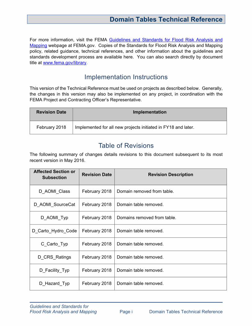
Guidelines and Standards for Flood Risk Analysis and Mapping Page i Domain Tables Technical Reference
For more information, visit the FEMA Guidelines and Standards for Flood Risk Analysis and Mapping webpage at FEMA.gov. Copies of the Standards for Flood Risk Analysis and Mapping policy, related guidance, technical references, and other information about the guidelines and standards development process are available here. You can also search directly by document title at www.fema.gov/library.
Implementation Instructions This version of the Technical Reference must be used on projects as described below. Generally, the changes in this version may also be implemented on any project, in coordination with the FEMA Project and Contracting Officer’s Representative.
Revision Date Implementation
February 2018 Implemented for all new projects initiated in FY18 and later.
Table of Revisions The following summary of changes details revisions to this document subsequent to its most recent version in May 2016.
Affected Section or Subsection Revision Date Revision Description
D_AOMI_Class February 2018 Domain removed from table.
D_AOMI_SourceCat February 2018 Domain table removed.
D_AOMI_Typ February 2018 Domains removed from table.
D_Carto_Hydro_Code February 2018 Domain table removed.
C_Carto_Typ February 2018 Domain table removed.
D_CRS_Ratings February 2018 Domain table removed.
D_Facility_Typ February 2018 Domain table removed.
D_Hazard_Typ February 2018 Domain table removed.

Guidelines and Standards for Flood Risk Analysis and Mapping Page ii Domain Tables Technical Reference
Affected Section or Subsection Revision Date Revision Description
D_Pol_Typ February 2018 Domain table removed.
D_RA_Source February 2018 Domain table removed.
D_Study_Mth February 2018 New table to provide study methods more detail.
by stream in
D_Study_Typ February 2018 Revised table to provide domains that align with BLE study methods.
D_Topo_Typ February 2018 Domain table removed.

Guidelines and Standards for Flood Risk Analysis and Mapping Page iii Domain Tables Technical Reference
Table of Contents
1.0 Document Overview ........................................................................................................... 1
2.0 Domain Tables ................................................................................................................... 1
2.1 D_AOMI_Class ........................................................................................................... 1
2.2 D_AOMI_Typ .............................................................................................................. 1
2.3 D_Area_Units .............................................................................................................. 2
2.4 D_Basemap_Typ ........................................................................................................ 2
2.5 D_BeachSet ................................................................................................................ 2
2.6 D_Breach_Pt_Typ ....................................................................................................... 3
2.7 D_Carto_Trans_Code ................................................................................................. 3
2.8 D_CBRS_Typ ............................................................................................................. 4
2.9 D_Cert_Status ............................................................................................................ 4
2.10 D_Change ................................................................................................................... 4
2.11 D_Const_Typ .............................................................................................................. 5
2.12 D_Cst_Struct ............................................................................................................... 5
2.13 D_Cst_Typ .................................................................................................................. 6
2.14 D_Discharge_Units ..................................................................................................... 6
2.15 D_Erosion ................................................................................................................... 6
2.16 D_Esmt_Typ ............................................................................................................... 7
2.17 D_Event ...................................................................................................................... 7
2.18 D_Flooding_Source .................................................................................................... 8
2.19 D_Flood_Typ .............................................................................................................. 8
2.20 D_Font ........................................................................................................................ 8
2.21 D_Font_Style .............................................................................................................. 9
2.22 D_Gage_Typ ............................................................................................................... 9
2.23 D_HAZ_Class ........................................................................................................... 10
2.24 D_Horiz_Datum ........................................................................................................ 10
2.25 D_Hydra_Mdl ............................................................................................................ 10
2.26 D_Hydro_Mdl ............................................................................................................ 13
2.27 D_Jurisdiction_Typ ................................................................................................... 14
2.28 D_Label_Typ ............................................................................................................. 15

Guidelines and Standards for Flood Risk Analysis and Mapping Page iv Domain Tables Technical Reference
2.29 D_Length_Units ........................................................................................................ 15
2.30 D_Levee_Accreditation ............................................................................................. 16
2.31 D_Levee_Analysis_Type .......................................................................................... 16
2.32 D_Levee_Event ........................................................................................................ 16
2.33 D_Levee_Pt_Typ ...................................................................................................... 17
2.34 D_Levee_Scenario ................................................................................................... 18
2.35 D_Levee_Status ....................................................................................................... 18
2.36 D_Levee_Typ ............................................................................................................ 18
2.37 D_Ln_Typ ................................................................................................................. 18
2.38 D_Loc_Accuracy ....................................................................................................... 19
2.39 D_LOMC_Status ....................................................................................................... 19
2.40 D_Method ................................................................................................................. 20
2.41 D_MTFCC ................................................................................................................. 20
2.42 D_Mtg_Typ ............................................................................................................... 21
2.43 D_Node_Typ ............................................................................................................. 21
2.44 D_Obscured .............................................................................................................. 21
2.45 D_Occupancy_Typ ................................................................................................... 22
2.46 D_Panel_Typ ............................................................................................................ 23
2.47 D_PFD_Size ............................................................................................................. 23
2.48 D_Prof_Basln_Typ .................................................................................................... 24
2.49 D_Prof_Lbl_Adjust .................................................................................................... 24
2.50 D_Prof_Lbl_Orient .................................................................................................... 24
2.51 D_Proj_Unit ............................................................................................................... 24
2.52 D_Projection ............................................................................................................. 25
2.53 D_Projzone ............................................................................................................... 41
2.54 D_Quad_Corner ........................................................................................................ 52
2.55 D_Release_Typ ........................................................................................................ 52
2.56 D_Reservoir_Cond ................................................................................................... 52
2.57 D_Runup_Mdl ........................................................................................................... 53
2.58 D_Scale .................................................................................................................... 53
2.59 D_SFHA_FLDWY ..................................................................................................... 53
2.60 D_Shr_Typ ................................................................................................................ 54
2.61 D_State_FIPS ........................................................................................................... 54

Guidelines and Standards for Flood Risk Analysis and Mapping Page v Domain Tables Technical Reference
2.62 D_State_Name ......................................................................................................... 56
2.63 D_Struct_Face .......................................................................................................... 58
2.64 D_Struct_Mtl ............................................................................................................. 58
2.65 D_Struct_Typ ............................................................................................................ 58
2.66 D_Study_Mth ............................................................................................................ 60
2.67 D_Study_Prefix ......................................................................................................... 61
2.68 D_Study_Typ ............................................................................................................ 62
2.69 D_Subbasin_Typ ...................................................................................................... 63
2.70 D_Surge_Mdl ............................................................................................................ 63
2.71 D_Task_Typ .............................................................................................................. 63
2.72 D_Time_Units ........................................................................................................... 64
2.73 D_TrueFalse ............................................................................................................. 64
2.74 D_TsctBasln_Typ ...................................................................................................... 64
2.75 D_USACE_District .................................................................................................... 65
2.76 D_V_Datum .............................................................................................................. 66
2.77 D_Velocity_Units ....................................................................................................... 66
2.78 D_VZone ................................................................................................................... 67
2.79 D_Wave_Haz ............................................................................................................ 67
2.80 D_Wave_Mdl ............................................................................................................ 67
2.81 D_XS_Ln_Typ ........................................................................................................... 68
2.82 D_Zone ..................................................................................................................... 68
2.83 D_Zone_Subtype ...................................................................................................... 69

Guidelines and Standards for Flood Risk Analysis and Mapping Page 1 Domain Tables Technical Reference
1.0 Document Overview The Domain Tables Technical Reference is intended as a central repository for all allowable domain values referenced in spatial databases in the Guidelines and Standards for Flood Risk Analysis and Mapping. All domain tables and their allowable values are listed in alphabetical order in this document.
Mapping Partners must use this document as a reference to identify valid values for appropriate domain tables in databases.
Note: In the “Applies to Database Schema” column:
• “FIRM” indicates that a value is only acceptable in the Flood Insurance Rate Map (FIRM) Database schema.
• “FRD” indicates that a value is only acceptable in the Flood Risk Database (FRD) schema.
• “FIRM, FRD” indicates that it is acceptable for both the FIRM and FRD database schemas.
• “NFHL” indicates this domain value is only used in the National Flood Hazard Layer (NFHL) database schema.
2.0 Domain Tables
2.1 D_AOMI_Class
This domain table is referenced in the FRD database schema.
Coded Value Area of Mitigation Interest Description
Applies to Database Schema
RIV Riverine FRD COAS Coastal FRD OTH Other FRD NP NP FRD
2.2 D_AOMI_Typ
This domain table is referenced in the FRD database schema.
Coded Value Area of Mitigation Interest Description
Type Applies to Database Schema
0200 Non-Accredited Levees FRD
0300 Coastal Structures FRD
0400 Streamflow Constrictions FRD

Guidelines and Standards for Flood Risk Analysis and Mapping Page 2 Domain Tables Technical Reference
Coded Value Area of Mitigation Interest Type Description
Applies to Database Schema
0500 Key Emergency Routes Overtopped FRD
0600 Past Claims Hot Spot FRD
0800 Significant Land Use Change FRD
1000 Non-Levee Embankments FRD
1100 At Risk Essential Facilities FRD
9000 Other FRD
NP NP FRD
2.3 D_Area_Units
This domain table is referenced in the FIRM database schema.
Coded Value Type of Area Unit Applies to Database Schema
1000 Acres FIRM 1010 Hectares FIRM 1020 Square Feet FIRM 1030 Square Meters FIRM 1040 Square Yards FIRM 1050 Square Miles FIRM 1060 Square Kilometers FIRM NP NP FIRM
2.4 D_Basemap_Typ
This domain table is referenced in the FIRM database schema.
Coded Value Type of Base Map Applies to Database Schema
1000 Orthophoto FIRM 2000 Vector FIRM NP NP FIRM
2.5 D_BeachSet
This domain table is referenced in the FIRM database schema.

Guidelines and Standards for Flood Risk Analysis and Mapping Page 3 Domain Tables Technical Reference
Coded Value Type of Beach Setting Applies to Database Schema
1050 Cobble, Gravel, Shingle, or Mixed Grain Sized Beach and Berms FIRM
1020 Erodible Coastal Bluffs FIRM
1030 Non-Erodible Coastal Cliffs and Bluffs FIRM
1000 Sandy Beach Backed by Low Sand Berm or High Sand Dune Formation FIRM
1010 Sandy Beach Backed by Shore Protection Structures FIRM
1040 Tidal Flats and Wetlands FIRM NP NP FIRM
2.6 D_Breach_Pt_Typ
This domain table is referenced in the FRD database schema.
Coded Value Type of Breach Applies to Database Schema
H Community-supplied, historical FRD O Community-supplied, overtopping FRD
P Community-supplied, potential engineered breach location FRD
A Armored overtopping FRD
NP NP FRD
2.7 D_Carto_Trans_Code
This domain table is referenced in the FIRM and FRD database schemas.
Coded Value Cartographic Code Used for Symbolization Description
Applies to Database Schema
0100 Interstates FIRM, FRD 0200 US Highways FIRM, FRD 0300 State Highways FIRM, FRD 0400 County Roads FIRM, FRD 0500 Local Roads FIRM, FRD 0700 Railroads FIRM, FRD 0800 Airports FIRM, FRD
Guidelines and Standards for Flood Risk Analysis and Mapping Page 4 Domain Tables Technical Reference
Coded Value Cartographic Code Used for Symbolization Description
Applies to Database Schema
0900 User-Defined FRD 9000 Other FRD -8888 -8888 FRD
NP NP FIRM
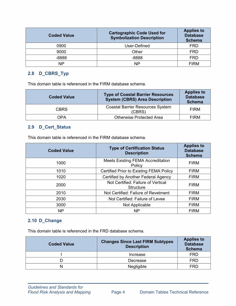
2.8 D_CBRS_Typ
This domain table is referenced in the FIRM database schema.
Coded Value Type of Coastal Barrier Resources System (CBRS) Area Description
Applies to Database Schema
CBRS Coastal Barrier Resources System (CBRS) FIRM
OPA Otherwise Protected Area FIRM
2.9 D_Cert_Status
This domain table is referenced in the FIRM database schema.
Coded Value Type of Certification Status Description
Applies to Database Schema
1000 Meets Existing FEMA Accreditation Policy FIRM
1010 Certified Prior to Existing FEMA Policy FIRM 1020 Certified by Another Federal Agency FIRM
2000 Not Certified: Failure of Vertical Structure FIRM
2010 Not Certified: Failure of Revetment FIRM 2030 Not Certified: Failure of Levee FIRM 3000 Not Applicable FIRM NP NP FIRM
2.10 D_Change
This domain table is referenced in the FRD database schema.
Coded Value Changes Since Last FIRM Subtypes Description
Applies to Database Schema
I Increase FRD D Decrease FRD N Negligible FRD

Coded Value Type of Coastal Structure Classification
Applies to Database Schema
1000 Beach Stabilization Structure FIRM 2000 Coastal Armoring Structure FIRM 3000 Miscellaneous Structure FIRM
Guidelines and Standards for Flood Risk Analysis and Mapping Page 5 Domain Tables Technical Reference
Coded Value Changes Since Last FIRM Subtypes Description
Applies to Database Schema
Z None (Zero) FRD U Unknown FRD
2.11 D_Const_Typ
This domain table is referenced in the FRD database schema.
Coded Value Construction Type Description Applies to Database Schema
ARCH Arch FRD
ARGV Arch-Gravity FRD
ASCN Asphalt-Concrete FRD
BARR Barrage FRD
CLAY Clay FRD
CONC Concrete of Masonry FRD
ERFL Earth-Fill FRD
FMIX Fill Mix (clay/silt/sand) FRD
GRAV Gravity FRD
RKFL Rock-Fill FRD
OTH Other FRD
NP NP FRD
2.12 D_Cst_Struct
This domain table is referenced in the FIRM database schema.

Guidelines and Standards for Flood Risk Analysis and Mapping Page 6 Domain Tables Technical Reference
Coded Value Type of Coastal Structure Classification
Applies to Database Schema
NP NP FIRM
2.13 D_Cst_Typ
This domain table is referenced in the FIRM database schema.
Coded Value Type of Coastline Applies to Database Schema
1000 Open Coast FIRM 2000 Sheltered Waters FIRM
3000 Combined Open Coast and Sheltered Waters FIRM
NP NP FIRM
2.14 D_Discharge_Units
This domain table is referenced in the FIRM database schema.
Coded Value Type of Discharge Unit Applies to Database Schema
CFS CFS FIRM CMS CMS FIRM NP NP FIRM
CFS = Cubic feet per second CMS = Cubic meters per second
2.15 D_Erosion
This domain table is referenced in the FIRM database schema.
Coded Value Type of Erosion Description Applies to Database Schema
1010 Not Applied FIRM 1020 Dune Removal FIRM 1030 Dune Retreat FIRM 1040 K-D FIRM 1050 MK-A FIRM 1060 SBEACH FIRM 9000 Other FIRM NP NP FIRM

Coded Value FIRM Event Type Description FRD Event Type Description
Applies to Database Schema
AvgAnn - Average Annual FRD 50pct 50-Percent-Chance 50-Percent-Chance (2-yr) FIRM, FRD 20pct 20-Percent-Chance 20-Percent-Chance (5-yr) FRD 10pct 10-Percent-Chance 10-Percent-Chance (10-yr) FIRM, FRD 04pct 4-Percent-Chance 4-Percent-Chance (25-yr) FIRM, FRD 02pct 2-Percent-Chance 2-Percent-Chance (50-yr) FIRM, FRD 01plus 1-Percent-Plus-Chance 1-Percent-Plus-Chance FIRM, FRD
01minus 1-Percent-Minus-Chance 1-Percent-Minus-Chance FIRM, FRD 01pct 1-Percent-Chance 1-Percent-Chance (100-yr) FIRM, FRD
0_2pct 0.2-Percent-Chance 0.2-Percent-Chance (500-yr) FIRM, FRD 0_5pct - 0.5-Percent-Chance (200-yr) FRD
01pctfut 1-Percent-Chance Future Conditions - FIRM
PMF - Probable Maximum Flood FRD PMF14 - 1/4 of Probable Maximum Flood FRD PMF13 - 1/3 of Probable Maximum Flood FRD PMF12 - 1/2 of Probable Maximum Flood FRD PMF34 - 3/4 of Probable Maximum Flood FRD PMP - Probable Maximum Precipitation FRD
PMP14 - 1/4 of Probable Maximum Precipitation FRD
PMP13 - 1/3 of Probable Maximum Precipitation FRD
Guidelines and Standards for Flood Risk Analysis and Mapping Page 7 Domain Tables Technical Reference
2.16 D_Esmt_Typ
This domain table is referenced in the FRD database schema.
Coded Value Easement Type Applies to Database Schema
CONS CONSERVATION FRD
DRAN DRAINAGE FRD
FLOW FLOWAGE FRD
NP NP FRD
2.17 D_Event
This domain table is referenced in the FIRM and FRD database schemas.
Guidelines and Standards for Flood Risk Analysis and Mapping Page 8 Domain Tables Technical Reference
Coded Value FIRM Event Type Description FRD Event Type Description
Applies to Database Schema
PMP12 - 1/2 of Probable Maximum Precipitation FRD
PMP34 - 3/4 of Probable Maximum Precipitation FRD
SUN - Sunny Day FRD FOR - Flood of Record FRD OTH - Other FRD
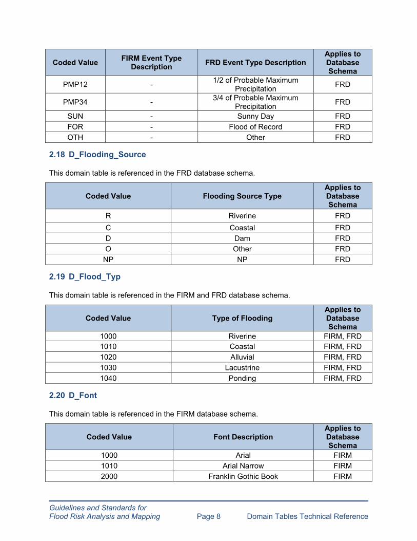
2.18 D_Flooding_Source
This domain table is referenced in the FRD database schema.
Coded Value Flooding Source Type Applies to Database Schema
R Riverine FRD C Coastal FRD D Dam FRD O Other FRD
NP NP FRD
2.19 D_Flood_Typ
This domain table is referenced in the FIRM and FRD database schema.
Coded Value Type of Flooding Applies to Database Schema
1000 Riverine FIRM, FRD 1010 Coastal FIRM, FRD 1020 Alluvial FIRM, FRD 1030 Lacustrine FIRM, FRD 1040 Ponding FIRM, FRD
2.20 D_Font
This domain table is referenced in the FIRM database schema.
Coded Value Font Description Applies to Database Schema
1000 Arial FIRM 1010 Arial Narrow FIRM 2000 Franklin Gothic Book FIRM

Guidelines and Standards for Flood Risk Analysis and Mapping Page 9 Domain Tables Technical Reference
Coded Value Font Description Applies to Database Schema
2010 Franklin Gothic Medium FIRM 2020 Franklin Gothic Medium Cond FIRM 3000 Times New Roman FIRM 4000 Verdana FIRM NP NP FIRM
2.21 D_Font_Style
This domain table is referenced in the FIRM database schema.
Coded Value Font Style Applies to Database Schema
1000 Regular FIRM 2000 Bold FIRM 3000 Italic FIRM 4000 Bold Italic FIRM NP NP FIRM
2.22 D_Gage_Typ
This domain table is referenced in the FIRM database schema.
Coded Value Type of Gage Applies to Database Schema
1000 Flow FIRM 1010 Flow / Stage FIRM 1020 Stage FIRM 1100 Fixed Interval FIRM 1110 Instantaneous FIRM 1200 Wave Height FIRM 1210 Wind Direction FIRM 1220 Wind Speed FIRM 1230 Wind Speed and Direction FIRM 1240 Tide FIRM 1120 Tipping FIRM 1250 Wave Height and Direction FIRM NP NP FIRM

Guidelines and Standards for Flood Risk Analysis and Mapping Page 10 Domain Tables Technical Reference
2.23 D_HAZ_Class
This domain table is referenced in the FRD database schema.
Coded Value Hazard Class Description Applies to Database Schema
HIGH High FRD SIG Significant FRD
LOW Low FRD NP NP FRD
2.24 D_Horiz_Datum
This domain table is referenced in the FIRM and FRD database schemas.
Coded Value Type of Horizontal Datum Applies to Database Schema
NAD27 North American Datum 1927 FIRM, FRD NAD83 North American Datum 1983 FIRM, FRD
83HARN North American Datum 1983 HARN FIRM, FRD WGS84 World Geodetic System 1984 FRD, NFHL NSRS07 NAD83 (NSRS2007) FIRM, FRD
NP NP FIRM, FRD
2.25 D_Hydra_Mdl
This domain table is referenced in the FIRM and FRD database schemas.
Coded Value Hydraulic Model Description Applies to Database Schema
0110 CHAN for Windows v. 2.03 (1997) FIRM, FRD
0120 Culvert Master v. 2.0 (September 2000) and up FIRM, FRD
1001 DHM 21 and 34 (Aug. 1987) FIRM, FRD
0140 FAN FIRM, FRD
1002 FEQ 8.92 (1999) and FEQ 9.98 (2005) FIRM, FRD
1003 FEQUTL 4.68 (1999) and FEQUTL 5.46 (2005) FIRM, FRD
1004 FESWMS 2DH 1.1 and up (Jun. 1995) FIRM, FRD

Guidelines and Standards for Flood Risk Analysis and Mapping Page 11 Domain Tables Technical Reference
Coded Value Hydraulic Model Description Applies to Database Schema
1005 FLDWAV (Nov. 1998) FIRM, FRD
1006 FLO-2D v. 2007.06 and 2009.06 FIRM, FRD
1007 FLO-2D V.2003.6, 2004.10 and 2006.1 FIRM, FRD
1008 Gage Analysis FIRM, FRD
1009 HCSWMM 4.31B (August 2000) FIRM, FRD
1010 HEC-2 4.6.2 (May 1991) FIRM, FRD
1012 HEC-RAS 3.1.1 and up FIRM, FRD
1014 HEC-RAS 5.0 and up FIRM, FRD
1013 HY8 4.1 and up (Nov. 1992) FIRM, FRD
1000 ICPR 2.20 (Oct. 2000), 3.02 (Nov. 2002), and 3.10 (April 2008) with PercPack Option FIRM, FRD
1015 MIKE 11 HD (2002 D, 2004) FIRM, FRD
1030 MIKE 11 HD v.2009 SP4 FIRM, FRD
0260 MIKE Flood HD (2002 D and 2004) FIRM, FRD
1028 MIKE URBAN Collection Systems (MOUSE) Release 2009, date June 2010 FIRM, FRD
0262 MIKE Flood HD v.2009 SP4 FIRM, FRD
0270 NETWORK (June 2002) FIRM, FRD
0280 PondPack v. 8 (May 2002) and up FIRM, FRD
1017 QUICK-2 1.0 and up (Jan. 1995) FIRM, FRD
0300 S2DMM (Feb 2008) FIRM, FRD
0401 SMS ADH v11.1 and up FIRM, FRD
0402 SMS ADCIRC v11.1 and up FIRM, FRD
0403 SMS BOUSS-2D v11.1 and up FIRM, FRD
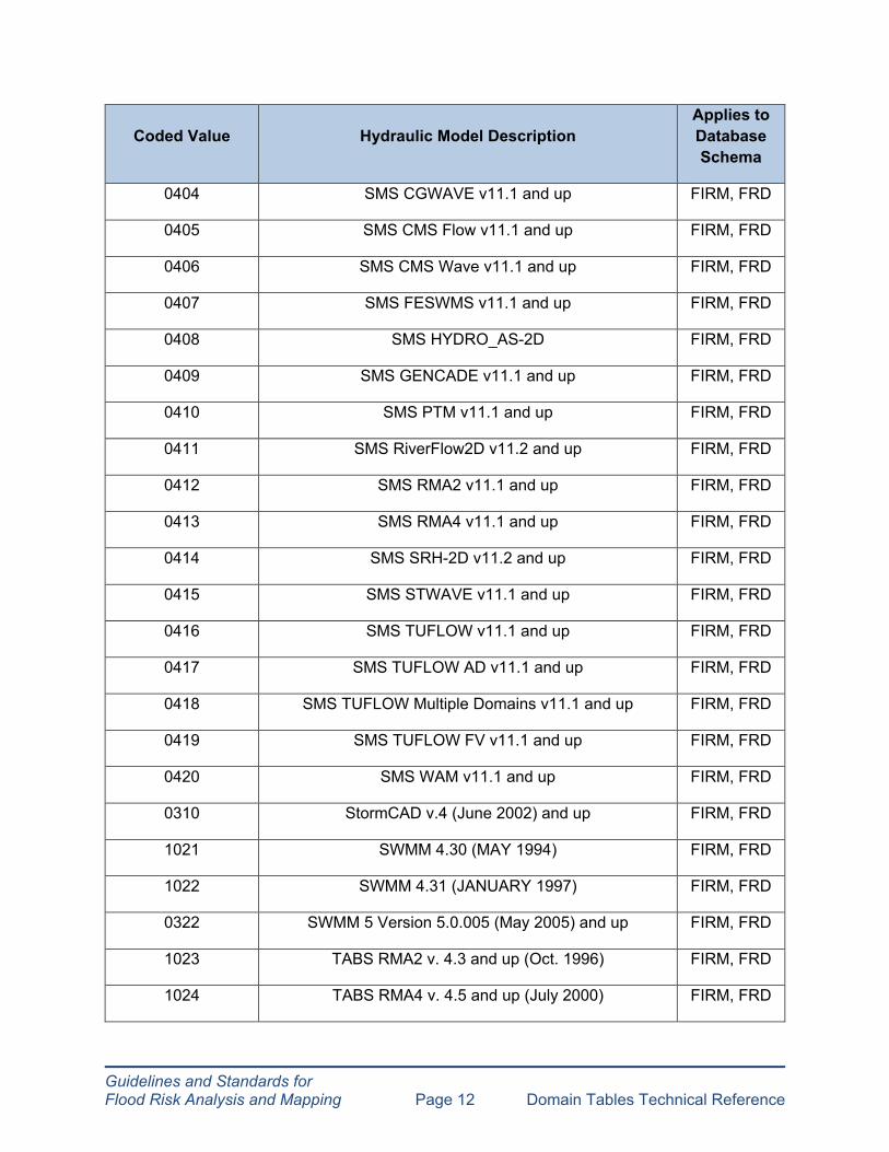
Guidelines and Standards for Flood Risk Analysis and Mapping Page 12 Domain Tables Technical Reference
Coded Value Hydraulic Model Description Applies to Database Schema
0404 SMS CGWAVE v11.1 and up FIRM, FRD
0405 SMS CMS Flow v11.1 and up FIRM, FRD
0406 SMS CMS Wave v11.1 and up FIRM, FRD
0407 SMS FESWMS v11.1 and up FIRM, FRD
0408 SMS HYDRO_AS-2D FIRM, FRD
0409 SMS GENCADE v11.1 and up FIRM, FRD
0410 SMS PTM v11.1 and up FIRM, FRD
0411 SMS RiverFlow2D v11.2 and up FIRM, FRD
0412 SMS RMA2 v11.1 and up FIRM, FRD
0413 SMS RMA4 v11.1 and up FIRM, FRD
0414 SMS SRH-2D v11.2 and up FIRM, FRD
0415 SMS STWAVE v11.1 and up FIRM, FRD
0416 SMS TUFLOW v11.1 and up FIRM, FRD
0417 SMS TUFLOW AD v11.1 and up FIRM, FRD
0418 SMS TUFLOW Multiple Domains v11.1 and up FIRM, FRD
0419 SMS TUFLOW FV v11.1 and up FIRM, FRD
0420 SMS WAM v11.1 and up FIRM, FRD
0310 StormCAD v.4 (June 2002) and up FIRM, FRD
1021 SWMM 4.30 (MAY 1994) FIRM, FRD
1022 SWMM 4.31 (JANUARY 1997) FIRM, FRD
0322 SWMM 5 Version 5.0.005 (May 2005) and up FIRM, FRD
1023 TABS RMA2 v. 4.3 and up (Oct. 1996) FIRM, FRD
1024 TABS RMA4 v. 4.5 and up (July 2000) FIRM, FRD

Guidelines and Standards for Flood Risk Analysis and Mapping Page 13 Domain Tables Technical Reference
Coded Value Hydraulic Model Description Applies to Database Schema
1029 TUFLOW Release Version 2010-10 (October 2010) FIRM, FRD
1025 UNET 4.0 (April 2001) FIRM, FRD
1026 WSPGW 12.96 (OCTOBER 2000) FIRM, FRD
1027 WSPRO (Jun. 1988 and up) FIRM, FRD
0370 Xpstorm 10.0 (May 2006) FIRM, FRD
0362 XPSWMM 2D/XPStorm 2D v. 12.00 (May 2010) FIRM, FRD
0360 XP-SWMM 8.52 and up FIRM, FRD
9000 Other FIRM, FRD
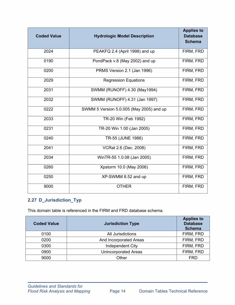
2.26 D_Hydro_Mdl
This domain table is referenced in the FIRM and FRD database schema.
Coded Value Hydrologic Model Description Applies to Database Schema
2000 AHYMO 97 (Aug. 1997) FIRM, FRD
2001 CUHPF/PC (May 1996 and May 2002) FIRM, FRD
2006 HEC-1 4.0.1 and up 1 (May 1991) FIRM, FRD
2005 HEC-FFA 3.1 (February 1995) FIRM, FRD
2008 HEC-HMS 3.0 and up (Dec 2005) FIRM, FRD
2040 HEC-SSP 1.1 (April 2009) and up FIRM, FRD
2018 HSPF 10.10 (Dec 1993) and up FIRM, FRD
2042 MIKE 11 (2009 SP4) FIRM, FRD
2022 MIKE 11 RR (2009 SP4) FIRM, FRD
2023 MIKE 11 UHM (2002 D and 2004) FIRM, FRD
Guidelines and Standards for Flood Risk Analysis and Mapping Page 14 Domain Tables Technical Reference
Coded Value Hydrologic Model Description Applies to Database Schema
2024 PEAKFQ 2.4 (April 1998) and up FIRM, FRD
0190 PondPack v.8 (May 2002) and up FIRM, FRD
0200 PRMS Version 2.1 (Jan 1996) FIRM, FRD
2029 Regression Equations FIRM, FRD
2031 SWMM (RUNOFF) 4.30 (May1994) FIRM, FRD
2032 SWMM (RUNOFF) 4.31 (Jan 1997) FIRM, FRD
0222 SWMM 5 Version 5.0.005 (May 2005) and up FIRM, FRD
2033 TR-20 Win (Feb 1992) FIRM, FRD
0231 TR-20 Win 1.00 (Jan 2005) FIRM, FRD
0240 TR-55 (JUNE 1986) FIRM, FRD
2041 VCRat 2.6 (Dec. 2008) FIRM, FRD
2034 WinTR-55 1.0.08 (Jan 2005) FIRM, FRD
0260 Xpstorm 10.0 (May 2006) FIRM, FRD
0250 XP-SWMM 8.52 and up FIRM, FRD
9000 OTHER FIRM, FRD
2.27 D_Jurisdiction_Typ
This domain table is referenced in the FIRM and FRD database schema.
Coded Value Jurisdiction Type Applies to Database Schema
0100 All Jurisdictions FIRM, FRD 0200 And Incorporated Areas FIRM, FRD 0300 Independent City FIRM, FRD 0900 Unincorporated Areas FIRM, FRD 9000 Other FRD

Coded Value Type of Length Unit Applies to Database Schema
CM Centimeters FIRM, FRD FT Feet FIRM, FRD IN Inches FIRM KM Kilometers FIRM M Meters FIRM
Guidelines and Standards for Flood Risk Analysis and Mapping Page 15 Domain Tables Technical Reference
2.28 D_Label_Typ
This domain table is referenced in the FIRM database schema.
Coded Value Type of Feature to Which the Labels and Leaders Apply
Applies to Database Schema
1000 Ortho-Transportation FIRM 1001 Ortho-Water FIRM 1002 S_Trnsport_Ln FIRM 1003 S_Wtr_Ar FIRM 1004 S_Wtr_Ln FIRM 1005 Notes and Map Collar FIRM 1006 S_BFE FIRM 1007 S_CBRS FIRM 1008 S_Cst_Tsct_Ln FIRM 1009 S_FIRM_Pan FIRM 1010 S_Fld_Haz_Ar FIRM 1011 S_Fld_Haz_Ln FIRM 1012 S_Gage FIRM 1013 S_Gen_Struct FIRM 1014 S_Levee FIRM 1015 S_LiMWA FIRM 1016 S_PFD_Ln FIRM 1017 S_PLSS_Ar FIRM 1018 S_Pol_Ar FIRM 1019 S_Profil_Basln FIRM 1020 S_Riv_Mrk FIRM 1021 S_Tsct_Basln FIRM 1022 S_XS FIRM NP NP FIRM
2.29 D_Length_Units
This domain table is referenced in the FIRM and FRD database schema.

Guidelines and Standards for Flood Risk Analysis and Mapping Page 16 Domain Tables Technical Reference
Coded Value Type of Length Unit Applies to Database Schema
MI Miles FIRM MM Millimeters FIRM
USFT U.S. Survey Feet FIRM, FRD NP NP FIRM, FRD
2.30 D_Levee_Accreditation
This domain table is referenced in the FRD database schema.
Coded Value Type of Accreditation Applies to Database Schema
A Accredited FRD P Provisionally Accredited FRD N Non-Accredited FRD
NP NP FRD
2.31 D_Levee_Analysis_Type
This domain table is referenced in the FRD database schema.
Coded Value Type of Levee Analysis Applies to Database Schema
NV Natural Valley FRD OVR Overtopping FRD FD Freeboard Deficient FRD
OTH Other FRD AL Accredited Levee FRD SR Sound Reach FRD SBI Structural-Based Inundation FRD NP NP FRD
2.32 D_Levee_Event
This domain table is referenced in the FRD database schema.
Coded Value Type of Event Applies to Database Schema
0_2 0.2% Annual Chance Event FRD 01 1% Annual Chance Event FRD
01P 1% Plus Annual Chance Event FRD

Guidelines and Standards for Flood Risk Analysis and Mapping Page 17 Domain Tables Technical Reference
Coded Value Type of Event Applies to Database Schema
02 2% Annual Chance Event FRD 04 4% Annual Chance Event FRD 10 10% Annual Chance Event FRD
HIS Historical Flood Event FRD LS Levee Shadow FRD
OVT Overtop FRD TOE Levee Toe (wet side of levee) FRD LC Levee Crest FRD LT Landward Toe FRD NP NP FRD
2.33 D_Levee_Pt_Typ
This domain table is referenced in the FRD database schema.
Coded Value Type of Levee Point Applies to Database Schema
BOIL Sand Boil Point FRD BORE Borehole Point FRD
CROSS Levee Crossing Point FRD ENCR Encroachment Point FRD FAIL Levee Failure Point FRD
FIGHT Flood Fight Point FRD PIEZ Piezometer Point FRD
PUMP Pump Station Point FRD RWP Levee Relief Well Point FRD STA Levee Station Point FRD
CLOS Closure Structure FRD GRAV Gravity Drain FRD LEVST Levee Station Point FRD
TOE Toe Drain FRD REHAB Rehabilitation Line FRD
NP NP FRD
Guidelines and Standards for Flood Risk Analysis and Mapping Page 18 Domain Tables Technical Reference
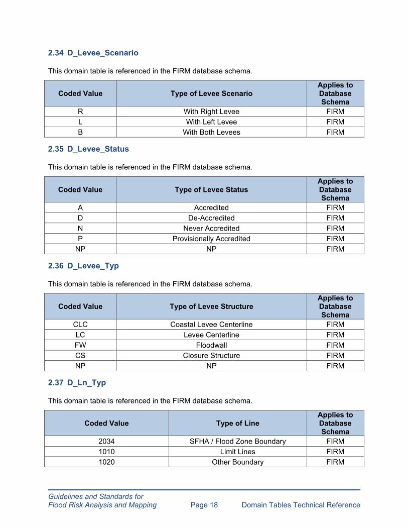
2.34 D_Levee_Scenario
This domain table is referenced in the FIRM database schema.
Coded Value Type of Levee Scenario Applies to Database Schema
R With Right Levee FIRM L With Left Levee FIRM B With Both Levees FIRM
2.35 D_Levee_Status
This domain table is referenced in the FIRM database schema.
Coded Value Type of Levee Status Applies to Database Schema
A Accredited FIRM D De-Accredited FIRM N Never Accredited FIRM P Provisionally Accredited FIRM
NP NP FIRM
2.36 D_Levee_Typ
This domain table is referenced in the FIRM database schema.
Coded Value Type of Levee Structure Applies to Database Schema
CLC Coastal Levee Centerline FIRM LC Levee Centerline FIRM FW Floodwall FIRM CS Closure Structure FIRM NP NP FIRM
2.37 D_Ln_Typ
This domain table is referenced in the FIRM database schema.
Coded Value Type of Line Applies to Database Schema
2034 SFHA / Flood Zone Boundary FIRM 1010 Limit Lines FIRM 1020 Other Boundary FIRM

Guidelines and Standards for Flood Risk Analysis and Mapping Page 19 Domain Tables Technical Reference
SFHA / FLOOD ZONE BOUNDARY category includes any line that forms the boundary of a floodplain zone, floodway, Limit of Floodway not at terminus of SFHA, or Limit of Detailed Study not at terminus of SFHA. This category does not include Limit of Detailed Study / Limit of Study lines at terminus of SFHA and other boundaries.
LIMIT LINES category includes lines that form the Limit of Detailed Study at terminus and Limit of Study, but not the edge of a floodplain or other boundaries.
OTHER BOUNDARY category includes any line types that do not form the edge of a SFHA, Floodway, Limit of Detailed Study, Limit of Study, and Limit of Floodway. These other boundaries do not get shown on the map. Examples include end of spatial extent, apparent limit, and source boundary.
2.38 D_Loc_Accuracy
This domain table is referenced in the FIRM database schema.
Coded Value Locational Accuracy Applies to Database Schema
H High FIRM M Medium FIRM L Low FIRM
HIGH locational accuracy includes any station start point that can be placed with a high degree of spatial accurately and usually applies to all new models.
MEDIUM locational accuracy includes any station start point that can obtained from old work maps with profile baselines or other source data which can be georeferenced to the new FIRM base map with a reasonable level of accuracy. This category usually applies to old models with good quality back-up data available at the FEMA Engineering Library.
LOW locational accuracy includes any station start point that cannot be placed accurately and for which only a text description exists, such as a note on the Floodway Data Table (FDT) or profile in the effective FIS. This category applies to old models with no or poor quality back-up data at the FEMA Engineering Library.
2.39 D_LOMC_Status
This domain table is referenced in the FIRM database schema.
Coded Value Type of Status Values for LOMCs Applies to Database Schema
1000 Superseded FIRM 1010 Revalidated FIRM 1020 Incorporated FIRM 1030 Redetermined FIRM

Guidelines and Standards for Flood Risk Analysis and Mapping Page 20 Domain Tables Technical Reference
Coded Value Type of Status Values for LOMCs Applies to Database Schema
1040 Effective FIRM NP NP FIRM
2.40 D_Method
This domain table is referenced in the FIRM database schema.
Coded Value Type of Elevation Source Method Applies to Database Schema
1000 Combo of Topo and Survey FIRM 1010 Cut from Topo FIRM 1020 Digitized from FIRM FIRM 1030 Field Survey FIRM
2.41 D_MTFCC
This domain table is referenced in the FIRM database schema.
Coded Value Type of US Census TIGER-Line Transportation Feature
Applies to Database Schema
R1011 Railroad Feature (Main, Spur, or Yard) FIRM
R1051 Carline, Streetcar Track, Monorail, Other Mass Transit Rail FIRM
R1052 Cog Rail Line, Incline Rail Line, Tram FIRM S1100 Primary Road FIRM S1200 Secondary Road FIRM S1400 Local Neighborhood Road, Rural Road, City Street FIRM S1500 Vehicular Trail (4WD) FIRM S1630 Ramp FIRM
S1640 Service Drive Usually Along a Limited Access Highway FIRM
S1710 Walkway/Pedestrian Trail FIRM S1720 Stairway FIRM S1730 Alley FIRM
S1740 Private Road for Service Vehicles (Logging, Oil Fields, Ranches, Etc.) FIRM
S1750 Internal U.S. Census Bureau Use FIRM S1780 Parking Lot Road FIRM S1820 Bike Path or Trail FIRM S1830 Bridle Path FIRM S2000 Road Median FIRM
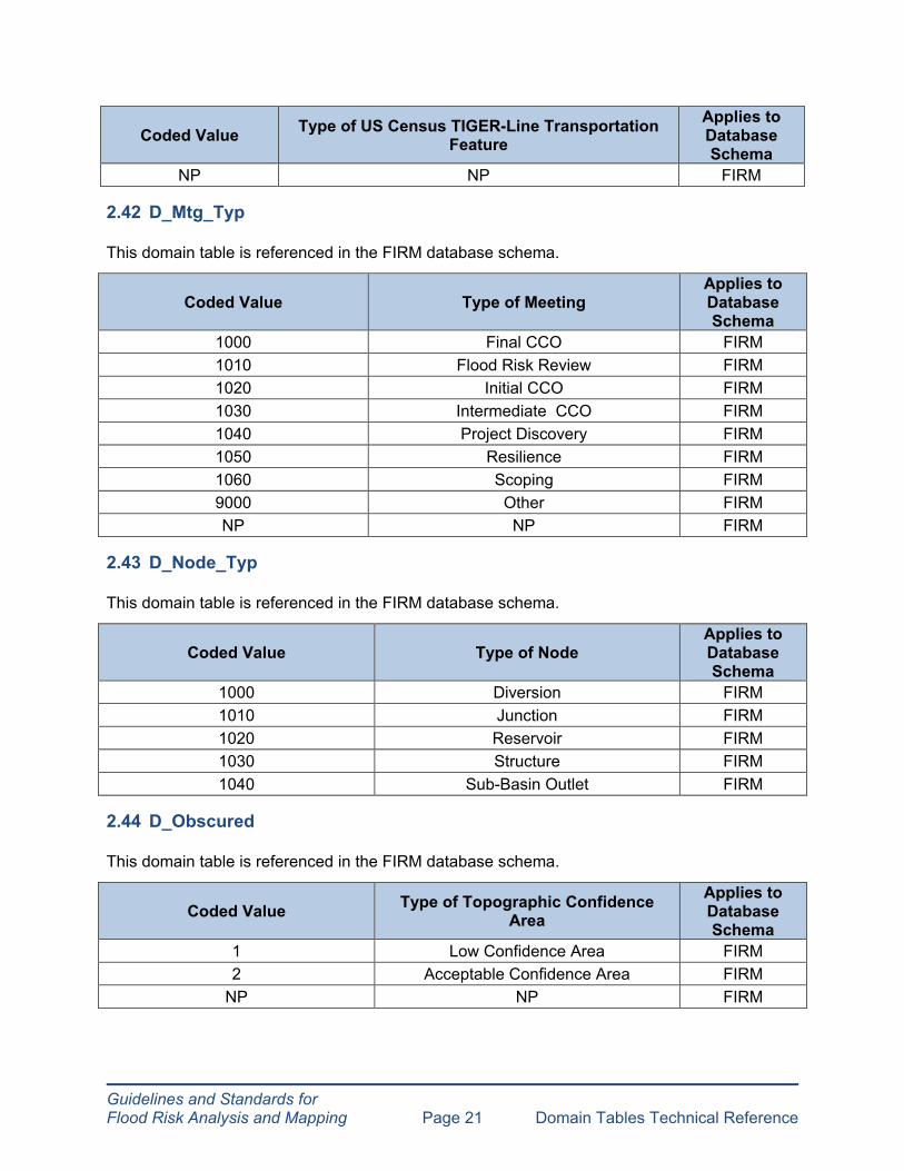
Guidelines and Standards for Flood Risk Analysis and Mapping Page 21 Domain Tables Technical Reference
Coded Value Type of US Census TIGER-Line Transportation Feature
Applies to Database Schema
NP NP FIRM
2.42 D_Mtg_Typ
This domain table is referenced in the FIRM database schema.
Coded Value Type of Meeting Applies to Database Schema
1000 Final CCO FIRM 1010 Flood Risk Review FIRM 1020 Initial CCO FIRM 1030 Intermediate CCO FIRM 1040 Project Discovery FIRM 1050 Resilience FIRM 1060 Scoping FIRM 9000 Other FIRM NP NP FIRM
2.43 D_Node_Typ
This domain table is referenced in the FIRM database schema.
Coded Value Type of Node Applies to Database Schema
1000 Diversion FIRM 1010 Junction FIRM 1020 Reservoir FIRM 1030 Structure FIRM 1040 Sub-Basin Outlet FIRM
2.44 D_Obscured
This domain table is referenced in the FIRM database schema.
Coded Value Type of Topographic Confidence Area
Applies to Database Schema
1 Low Confidence Area FIRM 2 Acceptable Confidence Area FIRM
NP NP FIRM
Guidelines and Standards for Flood Risk Analysis and Mapping Page 22 Domain Tables Technical Reference
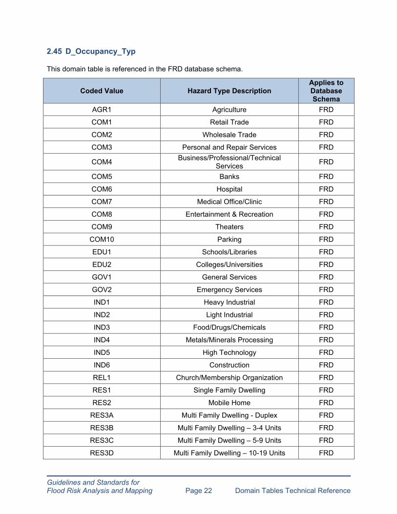
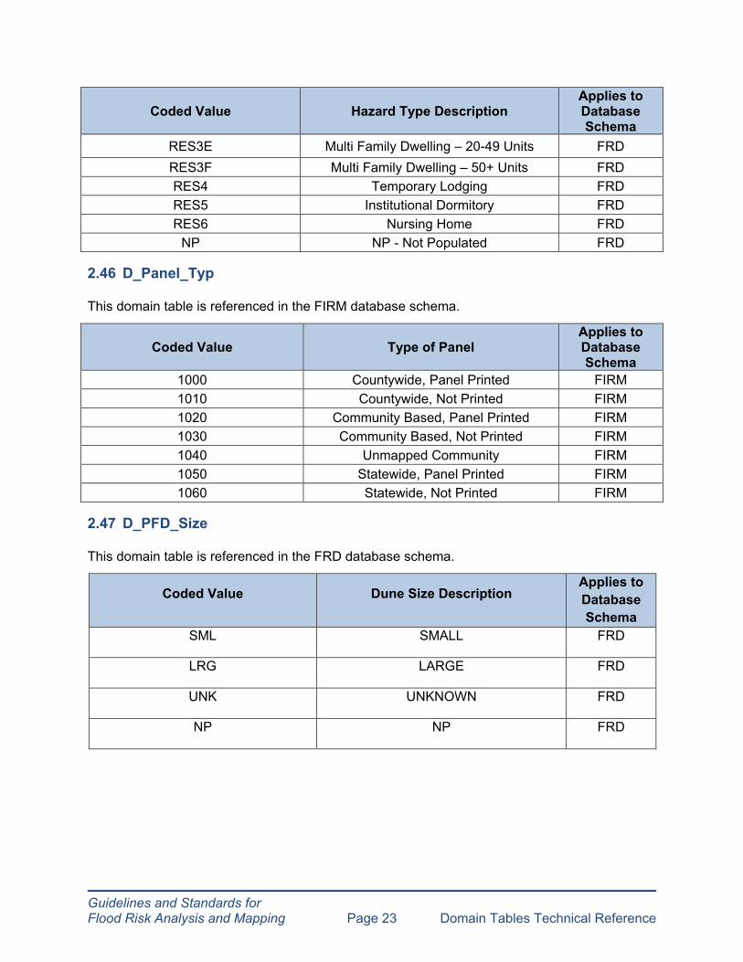
2.45 D_Occupancy_Typ
This domain table is referenced in the FRD database schema.
Coded Value Hazard Type Description Applies to Database Schema
AGR1 Agriculture FRD
COM1 Retail Trade FRD
COM2 Wholesale Trade FRD
COM3 Personal and Repair Services FRD
COM4 Business/Professional/Technical Services FRD
COM5 Banks FRD
COM6 Hospital FRD
COM7 Medical Office/Clinic FRD
COM8 Entertainment & Recreation FRD
COM9 Theaters FRD
COM10 Parking FRD
EDU1 Schools/Libraries FRD
EDU2 Colleges/Universities FRD
GOV1 General Services FRD
GOV2 Emergency Services FRD
IND1 Heavy Industrial FRD
IND2 Light Industrial FRD
IND3 Food/Drugs/Chemicals FRD
IND4 Metals/Minerals Processing FRD
IND5 High Technology FRD
IND6 Construction FRD
REL1 Church/Membership Organization FRD
RES1 Single Family Dwelling FRD
RES2 Mobile Home FRD
RES3A Multi Family Dwelling - Duplex FRD
RES3B Multi Family Dwelling – 3-4 Units FRD
RES3C Multi Family Dwelling – 5-9 Units FRD
RES3D Multi Family Dwelling – 10-19 Units FRD
Guidelines and Standards for Flood Risk Analysis and Mapping Page 23 Domain Tables Technical Reference
Coded Value Hazard Type Description Applies to Database Schema
RES3E Multi Family Dwelling – 20-49 Units FRD RES3F Multi Family Dwelling – 50+ Units FRD RES4 Temporary Lodging FRD RES5 Institutional Dormitory FRD RES6 Nursing Home FRD
NP NP - Not Populated FRD
2.46 D_Panel_Typ
This domain table is referenced in the FIRM database schema.
Coded Value Type of Panel Applies to Database Schema
1000 Countywide, Panel Printed FIRM 1010 Countywide, Not Printed FIRM 1020 Community Based, Panel Printed FIRM 1030 Community Based, Not Printed FIRM 1040 Unmapped Community FIRM 1050 Statewide, Panel Printed FIRM 1060 Statewide, Not Printed FIRM
2.47 D_PFD_Size
This domain table is referenced in the FRD database schema.
Coded Value Dune Size Description Applies to Database Schema
SML SMALL FRD
LRG LARGE FRD
UNK UNKNOWN FRD
NP NP FRD
Guidelines and Standards for Flood Risk Analysis and Mapping Page 24 Domain Tables Technical Reference
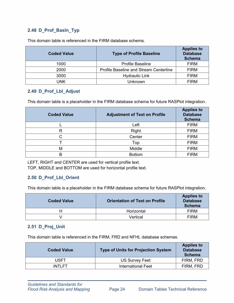
2.48 D_Prof_Basln_Typ
This domain table is referenced in the FIRM database schema.
Coded Value Type of Profile Baseline Applies to Database Schema
1000 Profile Baseline FIRM 2000 Profile Baseline and Stream Centerline FIRM 3000 Hydraulic Link FIRM UNK Unknown FIRM
2.49 D_Prof_Lbl_Adjust
This domain table is a placeholder in the FIRM database schema for future RASPlot integration.
Coded Value Adjustment of Text on Profile Applies to Database Schema
L Left FIRM R Right FIRM C Center FIRM T Top FIRM M Middle FIRM B Bottom FIRM
LEFT, RIGHT and CENTER are used for vertical profile text. TOP, MIDDLE and BOTTOM are used for horizontal profile text.
2.50 D_Prof_Lbl_Orient
This domain table is a placeholder in the FIRM database schema for future RASPlot integration.
Coded Value Orientation of Text on Profile Applies to Database Schema
H Horizontal FIRM V Vertical FIRM
2.51 D_Proj_Unit
This domain table is referenced in the FIRM, FRD and NFHL database schemas.
Coded Value Type of Units for Projection System Applies to Database Schema
USFT US Survey Feet FIRM, FRD INTLFT International Feet FIRM, FRD

Guidelines and Standards for Flood Risk Analysis and Mapping Page 25 Domain Tables Technical Reference
Coded Value Type of Units for Projection System Applies to Database Schema
METER Meters FIRM, FRD DECDEG Decimal Degrees NFHL, FRD
NP NP FIRM, FRD
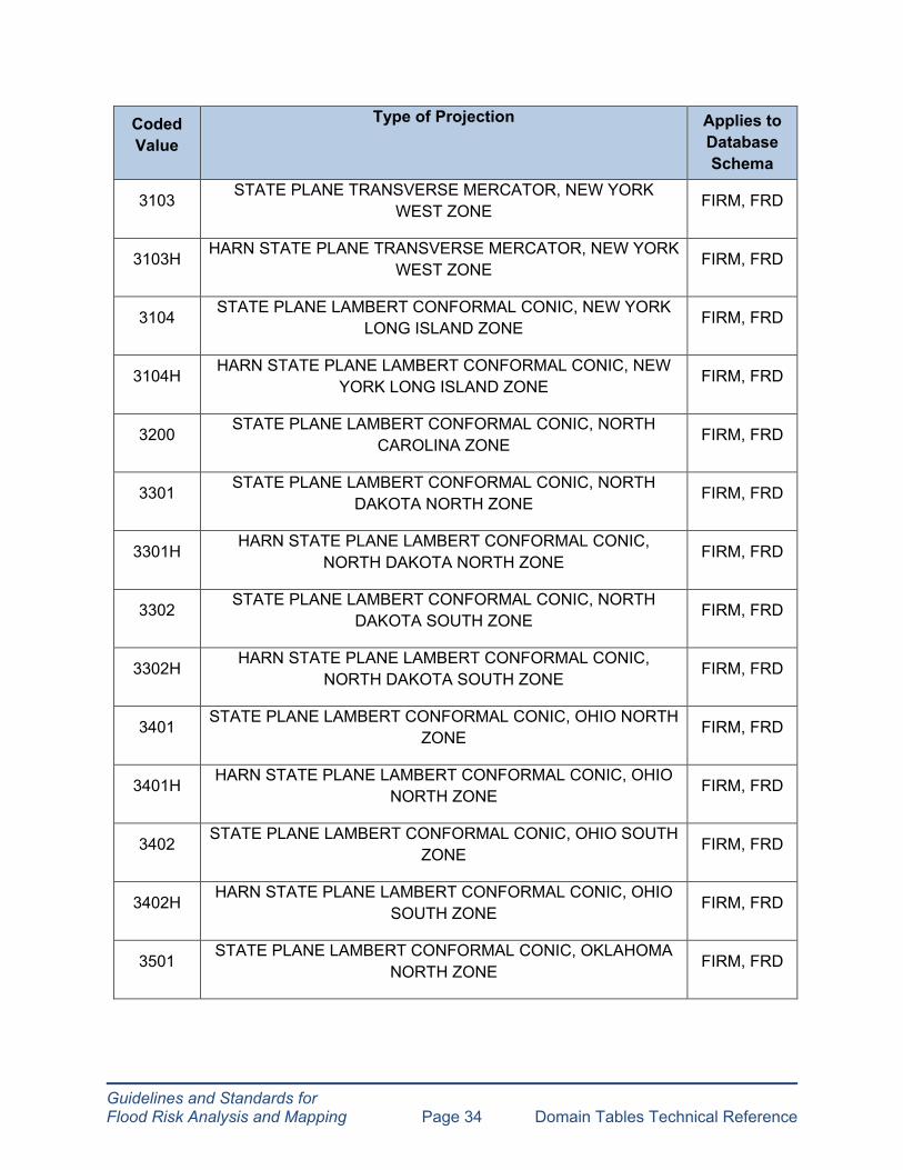
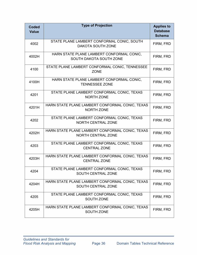
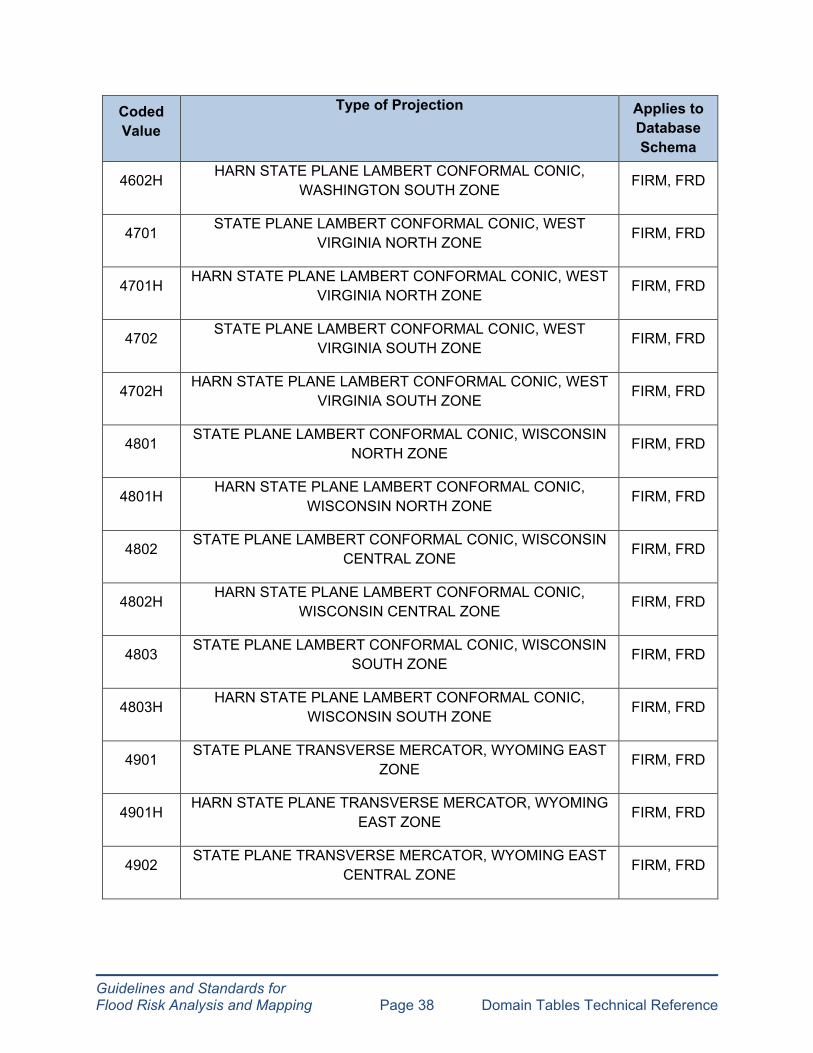
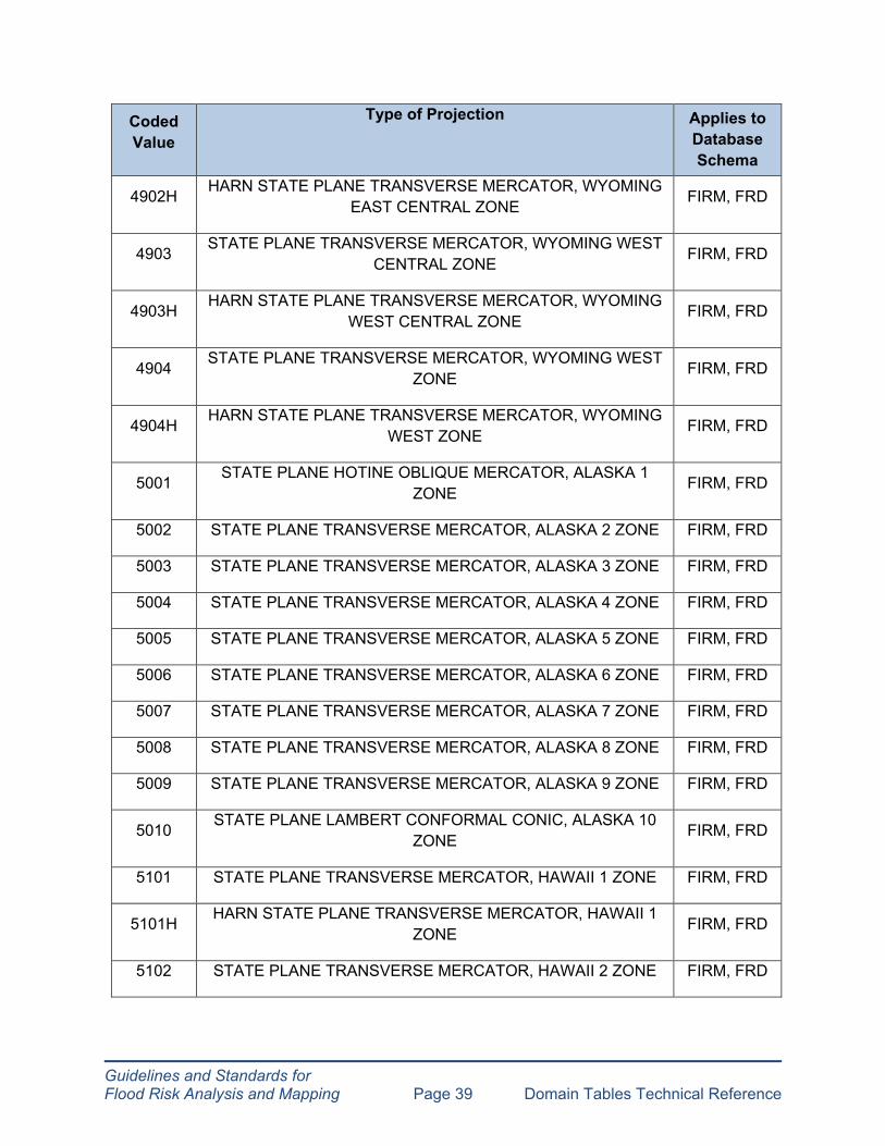
2.52 D_Projection
This domain table is referenced in the FIRM, FRD and NFHL database schemas.
Coded Value
Type of Projection
Applies to Database Schema
0101 STATE PLANE TRANSVERSE MERCATOR ALABAMA EAST ZONE FIRM, FRD
0101H HARN STATE PLANE TRANSVERSE MERCATOR, ALABAMA EAST ZONE FIRM, FRD
0102 STATE PLANE TRANSVERSE MERCATOR, ALABAMA WEST ZONE FIRM, FRD
0102H HARN STATE PLANE TRANSVERSE WEST ZONE
MERCATOR, ALABAMA FIRM, FRD
0201 STATE PLANE TRANSVERSE MERCATOR, ARIZONA EAST ZONE FIRM, FRD
0201H HARN STATE PLANE TRANSVERSE MERCATOR, ARIZONA
EAST ZONE FIRM, FRD
0202 STATE PLANE TRANSVERSE MERCATOR, ARIZONA
CENTRAL ZONE FIRM, FRD
0202H HARN STATE PLANE TRANSVERSE MERCATOR, ARIZONA CENTRAL ZONE
FIRM, FRD
0203 STATE PLANE TRANSVERSE MERCATOR, ARIZONA WEST ZONE FIRM, FRD
0203H HARN STATE PLANE TRANSVERSE MERCATOR, ARIZONA WEST ZONE FIRM, FRD
0301 STATE PLANE LAMBERT CONFORMAL NORTH ZONE
CONIC, ARKANSAS FIRM, FRD

Guidelines and Standards for Flood Risk Analysis and Mapping Page 26 Domain Tables Technical Reference
Coded Value
Type of Projection
Applies to Database Schema
0302 STATE PLANE LAMBERT CONFORMAL CONIC, ARKANSAS SOUTH ZONE FIRM, FRD
0401 STATE PLANE LAMBERT CONFORMAL CONIC, CALIFORNIA I ZONE FIRM, FRD
0401H HARN STATE PLANE LAMBERT CONFORMAL CONIC, CALIFORNIA I ZONE FIRM, FRD
0402 STATE PLANE LAMBERT CONFORMAL CONIC, CALIFORNIA II ZONE FIRM, FRD
0402H HARN STATE PLANE LAMBERT CONFORMAL CONIC,
CALIFORNIA II ZONE FIRM, FRD
0403 STATE PLANE LAMBERT CONFORMAL CONIC, CALIFORNIA III ZONE
FIRM, FRD
0403H HARN STATE PLANE LAMBERT CONFORMAL CONIC, CALIFORNIA III ZONE
FIRM, FRD
0404 STATE PLANE LAMBERT CONFORMAL CONIC, CALIFORNIA IV ZONE FIRM, FRD
0404H HARN STATE PLANE LAMBERT CONFORMAL CONIC, CALIFORNIA IV ZONE FIRM, FRD
0405 STATE PLANE LAMBERT CONFORMAL CONIC, CALIFORNIA V ZONE FIRM, FRD
0405H HARN STATE PLANE LAMBERT CONFORMAL CONIC, CALIFORNIA V ZONE FIRM, FRD
0406 STATE PLANE LAMBERT CONFORMAL CONIC, CALIFORNIA VI ZONE FIRM, FRD
0406H HARN STATE PLANE LAMBERT CONFORMAL CONIC,
CALIFORNIA VI ZONE FIRM, FRD
0501 STATE PLANE LAMBERT CONFORMAL CONIC, COLORADO
CENTRAL ZONE FIRM, FRD
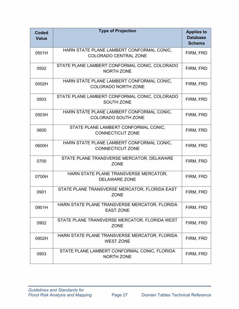
Guidelines and Standards for Flood Risk Analysis and Mapping Page 27 Domain Tables Technical Reference
Coded Value
Type of Projection
Applies to Database Schema
0501H HARN STATE PLANE LAMBERT CONFORMAL COLORADO CENTRAL ZONE
CONIC, FIRM, FRD
0502 STATE PLANE LAMBERT CONFORMAL NORTH ZONE
CONIC, COLORADO FIRM, FRD
0502H HARN STATE PLANE LAMBERT CONFORMAL COLORADO NORTH ZONE
CONIC, FIRM, FRD
0503 STATE PLANE LAMBERT CONFORMAL SOUTH ZONE
CONIC, COLORADO FIRM, FRD
0503H HARN STATE PLANE LAMBERT CONFORMAL
COLORADO SOUTH ZONE CONIC,
FIRM, FRD
0600 STATE PLANE LAMBERT CONFORMAL CONNECTICUT ZONE
CONIC, FIRM, FRD
0600H HARN STATE PLANE LAMBERT CONFORMAL CONNECTICUT ZONE
CONIC, FIRM, FRD
0700 STATE PLANE TRANSVERSE MERCATOR, DELAWARE ZONE FIRM, FRD
0700H HARN STATE PLANE TRANSVERSE MERCATOR, DELAWARE ZONE FIRM, FRD
0901 STATE PLANE TRANSVERSE MERCATOR, ZONE
FLORIDA EAST FIRM, FRD
0901H HARN STATE PLANE TRANSVERSE MERCATOR, FLORIDA EAST ZONE FIRM, FRD
0902 STATE PLANE TRANSVERSE MERCATOR, FLORIDA WEST ZONE FIRM, FRD
0902H HARN STATE PLANE TRANSVERSE MERCATOR, FLORIDA
WEST ZONE FIRM, FRD
0903 STATE PLANE LAMBERT CONFORMAL
NORTH ZONE CONIC, FLORIDA
FIRM, FRD

Guidelines and Standards for Flood Risk Analysis and Mapping Page 28 Domain Tables Technical Reference
Coded Value
Type of Projection
Applies to Database Schema
0903H HARN STATE PLANE LAMBERT CONFORMAL FLORIDA NORTH ZONE
CONIC, FIRM, FRD
1001 STATE PLANE TRANSVERSE MERCATOR, GEORGIA EAST ZONE FIRM, FRD
1001H HARN STATE PLANE TRANSVERSE MERCATOR, EAST ZONE
GEORGIA FIRM, FRD
1002 STATE PLANE TRANSVERSE MERCATOR, GEORGIA WEST ZONE FIRM, FRD
1002H HARN STATE PLANE TRANSVERSE MERCATOR, GEORGIA
WEST ZONE FIRM, FRD
1101 STATE PLANE TRANSVERSE MERCATOR, IDAHO EAST ZONE
FIRM, FRD
1101H HARN STATE PLANE TRANSVERSE MERCATOR, IDAHO EAST ZONE
FIRM, FRD
1102 STATE PLANE TRANSVERSE MERCATOR, IDAHO CENTRAL ZONE FIRM, FRD
1102H HARN STATE PLANE TRANSVERSE MERCATOR, IDAHO CENTRAL ZONE FIRM, FRD
1103 STATE PLANE TRANSVERSE MERCATOR, IDAHO WEST ZONE FIRM, FRD
1103H HARN STATE PLANE TRANSVERSE MERCATOR, IDAHO WEST ZONE FIRM, FRD
1201 STATE PLANE TRANSVERSE MERCATOR, ILLINOIS EAST ZONE FIRM, FRD
1201H HARN STATE PLANE TRANSVERSE MERCATOR, ILLINOIS
EAST ZONE FIRM, FRD
1202 STATE PLANE TRANSVERSE MERCATOR, ILLINOIS WEST
ZONE FIRM, FRD
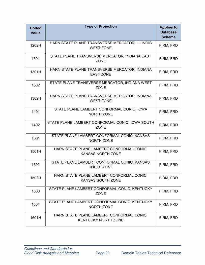
Guidelines and Standards for Flood Risk Analysis and Mapping Page 29 Domain Tables Technical Reference
Coded Value
Type of Projection
Applies to Database Schema
1202H HARN STATE PLANE TRANSVERSE MERCATOR, ILLINOIS WEST ZONE FIRM, FRD
1301 STATE PLANE TRANSVERSE MERCATOR, INDIANA EAST ZONE FIRM, FRD
1301H HARN STATE PLANE TRANSVERSE MERCATOR, INDIANA EAST ZONE FIRM, FRD
1302 STATE PLANE TRANSVERSE MERCATOR, INDIANA WEST ZONE FIRM, FRD
1302H HARN STATE PLANE TRANSVERSE MERCATOR, INDIANA
WEST ZONE FIRM, FRD
1401 STATE PLANE LAMBERT CONFORMAL CONIC, IOWA NORTH ZONE
FIRM, FRD
1402 STATE PLANE LAMBERT CONFORMAL ZONE
CONIC, IOWA SOUTH FIRM, FRD
1501 STATE PLANE LAMBERT CONFORMAL NORTH ZONE
CONIC, KANSAS FIRM, FRD
1501H HARN STATE PLANE LAMBERT CONFORMAL KANSAS NORTH ZONE
CONIC, FIRM, FRD
1502 STATE PLANE LAMBERT CONFORMAL SOUTH ZONE
CONIC, KANSAS FIRM, FRD
1502H HARN STATE PLANE LAMBERT CONFORMAL CONIC, KANSAS SOUTH ZONE FIRM, FRD
1600 STATE PLANE LAMBERT CONFORMAL ZONE
CONIC, KENTUCKY FIRM, FRD
1601 STATE PLANE LAMBERT CONFORMAL
NORTH ZONE CONIC, KENTUCKY
FIRM, FRD
1601H HARN STATE PLANE LAMBERT CONFORMAL
KENTUCKY NORTH ZONE CONIC,
FIRM, FRD

Guidelines and Standards for Flood Risk Analysis and Mapping Page 30 Domain Tables Technical Reference
Coded Value
Type of Projection
Applies to Database Schema
1602 STATE PLANE LAMBERT CONFORMAL SOUTH ZONE
CONIC, KENTUCKY FIRM, FRD
1602H HARN STATE PLANE LAMBERT CONFORMAL KENTUCKY SOUTH ZONE
CONIC, FIRM, FRD
1701 STATE PLANE LAMBERT CONFORMAL NORTH ZONE
CONIC, LOUISIANA FIRM, FRD
1701H HARN STATE PLANE LAMBERT CONFORMAL LOUISIANA NORTH ZONE
CONIC, FIRM, FRD
1702 STATE PLANE LAMBERT CONFORMAL
SOUTH ZONE CONIC, LOUISIANA
FIRM, FRD
1702H HARN STATE PLANE LAMBERT CONFORMAL LOUISIANA SOUTH ZONE
CONIC, FIRM, FRD
1801 STATE PLANE TRANSVERSE MERCATOR, ZONE
MAINE EAST FIRM, FRD
1801H HARN STATE PLANE TRANSVERSE MERCATOR, MAINE EAST ZONE FIRM, FRD
1802 STATE PLANE TRANSVERSE MERCATOR, ZONE
MAINE WEST FIRM, FRD
1802H HARN STATE PLANE TRANSVERSE MERCATOR, MAINE WEST ZONE FIRM, FRD
1900 STATE PLANE LAMBERT CONFORMAL ZONE
CONIC, MARYLAND FIRM, FRD
1900H HARN STATE PLANE LAMBERT CONFORMAL MARYLAND ZONE
CONIC, FIRM, FRD
2001 STATE PLANE LAMBERT CONFORMAL CONIC,
MASSACHUSETTS ISLAND ZONE FIRM, FRD
2001H HARN STATE PLANE LAMBERT CONFORMAL
MASSACHUSETTS ISLAND ZONE CONIC,
FIRM, FRD

Guidelines and Standards for Flood Risk Analysis and Mapping Page 31 Domain Tables Technical Reference
Coded Value
Type of Projection
Applies to Database Schema
2002 STATE PLANE LAMBERT CONFORMAL CONIC, MASSACHUSETTS MLAND ZONE FIRM, FRD
2002H HARN STATE PLANE LAMBERT CONFORMAL MASSACHUSETTS MLAND ZONE
CONIC, FIRM, FRD
2111 STATE PLANE LAMBERT CONFORMAL NORTH ZONE
CONIC, MICHIGAN FIRM, FRD
2111H HARN STATE PLANE LAMBERT CONFORMAL MICHIGAN NORTH ZONE
CONIC, FIRM, FRD
2112 STATE PLANE LAMBERT CONFORMAL
CENTRAL ZONE CONIC, MICHIGAN
FIRM, FRD
2112H HARN STATE PLANE LAMBERT CONFORMAL MICHIGAN CENTRAL ZONE
CONIC, FIRM, FRD
2113 STATE PLANE LAMBERT CONFORMAL SOUTH ZONE
CONIC, MICHIGAN FIRM, FRD
2113H HARN STATE PLANE LAMBERT CONFORMAL MICHIGAN SOUTH ZONE
CONIC, FIRM, FRD
2201 STATE PLANE LAMBERT CONFORMAL CONIC, MINNESOTA NORTH ZONE FIRM, FRD
2202 STATE PLANE LAMBERT CONFORMAL CENTRAL ZONE
CONIC, MINNESOTA FIRM, FRD
2203 STATE PLANE LAMBERT CONFORMAL CONIC, MINNESOTA SOUTH ZONE FIRM, FRD
2301 STATE PLANE TRANSVERSE MERCATOR, EAST ZONE
MISSISSIPPI FIRM, FRD
2301H HARN STATE PLANE TRANSVERSE MERCATOR,
MISSISSIPPI EAST ZONE FIRM, FRD
2302 STATE PLANE TRANSVERSE MERCATOR,
WEST ZONE MISSISSIPPI
FIRM, FRD

Guidelines and Standards for Flood Risk Analysis and Mapping Page 32 Domain Tables Technical Reference
Coded Value
Type of Projection
Applies to Database Schema
2302H HARN STATE PLANE TRANSVERSE MERCATOR, MISSISSIPPI WEST ZONE FIRM, FRD
2401 STATE PLANE TRANSVERSE MERCATOR, ZONE
MISSOURI EAST FIRM, FRD
2402 STATE PLANE TRANSVERSE MERCATOR, MISSOURI CENTRAL ZONE FIRM, FRD
2403 STATE PLANE TRANSVERSE MERCATOR, ZONE
MISSOURI WEST FIRM, FRD
2500 STATE PLANE LAMBERT CONFORMAL
ZONE CONIC, MONTANA
FIRM, FRD
2500H HARN STATE PLANE LAMBERT CONFORMAL MONTANA ZONE
CONIC, FIRM, FRD
2600 STATE PLANE LAMBERT CONFORMAL ZONE
CONIC, NEBRASKA FIRM, FRD
2600H HARN STATE PLANE LAMBERT CONFORMAL NEBRASKA ZONE
CONIC, FIRM, FRD
2701 STATE PLANE TRANSVERSE MERCATOR, NEVADA EAST ZONE FIRM, FRD
2701H HARN STATE PLANE TRANSVERSE MERCATOR, NEVADA EAST ZONE FIRM, FRD
2702 STATE PLANE TRANSVERSE MERCATOR, NEVADA CENTRAL ZONE FIRM, FRD
2702H HARN STATE PLANE TRANSVERSE MERCATOR, NEVADA CENTRAL ZONE FIRM, FRD
2703 STATE PLANE TRANSVERSE MERCATOR, NEVADA WEST
ZONE FIRM, FRD
2703H HARN STATE PLANE TRANSVERSE MERCATOR, NEVADA
WEST ZONE FIRM, FRD

Guidelines and Standards for Flood Risk Analysis and Mapping Page 33 Domain Tables Technical Reference
Coded Value
Type of Projection
Applies to Database Schema
2800 STATE PLANE LAMBERT CONFORMAL HAMPSHIRE ZONE
CONIC, NEW FIRM, FRD
2800H HARN STATE PLANE LAMBERT CONFORMAL HAMPSHIRE ZONE
CONIC, NEW FIRM, FRD
2900 STATE PLANE TRANSVERSE MERCATOR, NEW JERSEY ZONE FIRM, FRD
2900H HARN STATE PLANE TRANSVERSE MERCATOR, NEW JERSEY ZONE FIRM, FRD
3001 STATE PLANE TRANSVERSE MERCATOR, NEW MEXICO
EAST ZONE FIRM, FRD
3001H HARN STATE PLANE TRANSVERSE MERCATOR, NEW MEXICO EAST ZONE
FIRM, FRD
3002 STATE PLANE TRANSVERSE MERCATOR, NEW MEXICO CENTRAL ZONE
FIRM, FRD
3002H HARN STATE PLANE TRANSVERSE MERCATOR, NEW MEXICO CENTRAL ZONE FIRM, FRD
3003 STATE PLANE TRANSVERSE MERCATOR, NEW MEXICO WEST ZONE FIRM, FRD
3003H HARN STATE PLANE TRANSVERSE MERCATOR, NEW MEXICO WEST ZONE FIRM, FRD
3101 STATE PLANE TRANSVERSE MERCATOR, NEW YORK EAST ZONE FIRM, FRD
3101H HARN STATE PLANE TRANSVERSE MERCATOR, NEW YORK EAST ZONE FIRM, FRD
3102 STATE PLANE TRANSVERSE MERCATOR, NEW YORK
CENTRAL ZONE FIRM, FRD
3102H HARN STATE PLANE TRANSVERSE MERCATOR, NEW YORK
CENTRAL ZONE FIRM, FRD
Guidelines and Standards for Flood Risk Analysis and Mapping Page 34 Domain Tables Technical Reference
Coded Value
Type of Projection
Applies to Database Schema
3103 STATE PLANE TRANSVERSE MERCATOR, NEW YORK WEST ZONE FIRM, FRD
3103H HARN STATE PLANE TRANSVERSE MERCATOR, NEW YORK WEST ZONE FIRM, FRD
3104 STATE PLANE LAMBERT CONFORMAL CONIC, NEW YORK LONG ISLAND ZONE FIRM, FRD
3104H HARN STATE PLANE LAMBERT CONFORMAL YORK LONG ISLAND ZONE
CONIC, NEW FIRM, FRD
3200 STATE PLANE LAMBERT CONFORMAL
CAROLINA ZONE CONIC, NORTH
FIRM, FRD
3301 STATE PLANE LAMBERT CONFORMAL DAKOTA NORTH ZONE
CONIC, NORTH FIRM, FRD
3301H HARN STATE PLANE LAMBERT CONFORMAL NORTH DAKOTA NORTH ZONE
CONIC, FIRM, FRD
3302 STATE PLANE LAMBERT CONFORMAL DAKOTA SOUTH ZONE
CONIC, NORTH FIRM, FRD
3302H HARN STATE PLANE LAMBERT CONFORMAL NORTH DAKOTA SOUTH ZONE
CONIC, FIRM, FRD
3401 STATE PLANE LAMBERT CONFORMAL ZONE
CONIC, OHIO NORTH FIRM, FRD
3401H HARN STATE PLANE LAMBERT CONFORMAL NORTH ZONE
CONIC, OHIO FIRM, FRD
3402 STATE PLANE LAMBERT CONFORMAL ZONE
CONIC, OHIO SOUTH FIRM, FRD
3402H HARN STATE PLANE LAMBERT CONFORMAL
SOUTH ZONE CONIC, OHIO
FIRM, FRD
3501 STATE PLANE LAMBERT CONFORMAL
NORTH ZONE CONIC, OKLAHOMA
FIRM, FRD

Guidelines and Standards for Flood Risk Analysis and Mapping Page 35 Domain Tables Technical Reference
Coded Value
Type of Projection
Applies to Database Schema
3501H HARN STATE PLANE LAMBERT CONFORMAL OKLAHOMA NORTH ZONE
CONIC, FIRM, FRD
3502 STATE PLANE LAMBERT CONFORMAL SOUTH ZONE
CONIC, OKLAHOMA FIRM, FRD
3502H HARN STATE PLANE LAMBERT CONFORMAL OKLAHOMA SOUTH ZONE
CONIC, FIRM, FRD
3601 STATE PLANE LAMBERT CONFORMAL NORTH ZONE
CONIC, OREGON FIRM, FRD
3601H HARN STATE PLANE LAMBERT CONFORMAL
OREGON NORTH ZONE CONIC,
FIRM, FRD
3602 STATE PLANE LAMBERT CONFORMAL SOUTH ZONE
CONIC, OREGON FIRM, FRD
3602H HARN STATE PLANE LAMBERT CONFORMAL OREGON SOUTH ZONE
CONIC, FIRM, FRD
3701 STATE PLANE LAMBERT CONFORMAL PENNSYLVANIA NORTH ZONE
CONIC, FIRM, FRD
3702 STATE PLANE LAMBERT CONFORMAL PENNSYLVANIA SOUTH ZONE
CONIC, FIRM, FRD
3800 STATE PLANE TRANSVERSE MERCATOR, RHODE ISLAND ZONE FIRM, FRD
3800H HARN STATE PLANE TRANSVERSE MERCATOR, RHODE ISLAND ZONE FIRM, FRD
3900 STATE PLANE LAMBERT CONFORMAL CAROLINA ZONE
CONIC, SOUTH FIRM, FRD
4001 STATE PLANE LAMBERT CONFORMAL
DAKOTA NORTH ZONE CONIC, SOUTH
FIRM, FRD
4001H HARN STATE PLANE LAMBERT CONFORMAL
SOUTH DAKOTA NORTH ZONE CONIC,
FIRM, FRD
Guidelines and Standards for Flood Risk Analysis and Mapping Page 36 Domain Tables Technical Reference
Coded Value
Type of Projection
Applies to Database Schema
4002 STATE PLANE LAMBERT CONFORMAL DAKOTA SOUTH ZONE
CONIC, SOUTH FIRM, FRD
4002H HARN STATE PLANE LAMBERT CONFORMAL SOUTH DAKOTA SOUTH ZONE
CONIC, FIRM, FRD
4100 STATE PLANE LAMBERT CONFORMAL ZONE
CONIC, TENNESSEE FIRM, FRD
4100H HARN STATE PLANE LAMBERT CONFORMAL TENNESSEE ZONE
CONIC, FIRM, FRD
4201 STATE PLANE LAMBERT CONFORMAL
NORTH ZONE CONIC, TEXAS
FIRM, FRD
4201H HARN STATE PLANE LAMBERT CONFORMAL NORTH ZONE
CONIC, TEXAS FIRM, FRD
4202 STATE PLANE LAMBERT CONFORMAL NORTH CENTRAL ZONE
CONIC, TEXAS FIRM, FRD
4202H HARN STATE PLANE LAMBERT CONFORMAL NORTH CENTRAL ZONE
CONIC, TEXAS FIRM, FRD
4203 STATE PLANE LAMBERT CONFORMAL CENTRAL ZONE
CONIC, TEXAS FIRM, FRD
4203H HARN STATE PLANE LAMBERT CONFORMAL CENTRAL ZONE
CONIC, TEXAS FIRM, FRD
4204 STATE PLANE LAMBERT CONFORMAL SOUTH CENTRAL ZONE
CONIC, TEXAS FIRM, FRD
4204H HARN STATE PLANE LAMBERT CONFORMAL SOUTH CENTRAL ZONE
CONIC, TEXAS FIRM, FRD
4205 STATE PLANE LAMBERT CONFORMAL
SOUTH ZONE CONIC, TEXAS
FIRM, FRD
4205H HARN STATE PLANE LAMBERT CONFORMAL
SOUTH ZONE CONIC, TEXAS
FIRM, FRD

Type of Projection Applies to Coded Database Value Schema
STATE PLANE LAMBERT CONFORMAL CONIC, UTAH 4301 FIRM, FRD NORTH ZONE
HARN STATE PLANE LAMBERT CONFORMAL CONIC, UTAH 4301H FIRM, FRD NORTH ZONE
STATE PLANE LAMBERT CONFORMAL CONIC, UTAH 4302 FIRM, FRD CENTRAL ZONE
HARN STATE PLANE LAMBERT CONFORMAL CONIC, UTAH 4302H FIRM, FRD CENTRAL ZONE
STATE PLANE LAMBERT CONFORMAL CONIC, UTAH 4303 FIRM, FRD SOUTH ZONE
HARN STATE PLANE LAMBERT CONFORMAL CONIC, UTAH 4303H FIRM, FRD SOUTH ZONE
4400 STATE PLANE TRANSVERSE MERCATOR, VERMONT ZONE FIRM, FRD
HARN STATE PLANE TRANSVERSE MERCATOR, VERMONT 4400H FIRM, FRD ZONE
STATE PLANE LAMBERT CONFORMAL CONIC, VIRGINIA 4501 FIRM, FRD NORTH ZONE
HARN STATE PLANE LAMBERT CONFORMAL CONIC, 4501H FIRM, FRD VIRGINIA NORTH ZONE
STATE PLANE LAMBERT CONFORMAL CONIC, VIRGINIA 4502 FIRM, FRD SOUTH ZONE
HARN STATE PLANE LAMBERT CONFORMAL CONIC, 4502H FIRM, FRD VIRGINIA SOUTH ZONE
STATE PLANE LAMBERT CONFORMAL CONIC, 4601 FIRM, FRD WASHINGTON NORTH ZONE
HARN STATE PLANE LAMBERT CONFORMAL CONIC, 4601H FIRM, FRD WASHINGTON NORTH ZONE
STATE PLANE LAMBERT CONFORMAL CONIC, 4602 FIRM, FRD WASHINGTON SOUTH ZONE
Guidelines and Standards for Flood Risk Analysis and Mapping Page 37 Domain Tables Technical Reference
Guidelines and Standards for Flood Risk Analysis and Mapping Page 38 Domain Tables Technical Reference
Coded Value
Type of Projection
Applies to Database Schema
4602H HARN STATE PLANE LAMBERT CONFORMAL WASHINGTON SOUTH ZONE
CONIC, FIRM, FRD
4701 STATE PLANE LAMBERT CONFORMAL VIRGINIA NORTH ZONE
CONIC, WEST FIRM, FRD
4701H HARN STATE PLANE LAMBERT CONFORMAL VIRGINIA NORTH ZONE
CONIC, WEST FIRM, FRD
4702 STATE PLANE LAMBERT CONFORMAL VIRGINIA SOUTH ZONE
CONIC, WEST FIRM, FRD
4702H HARN STATE PLANE LAMBERT CONFORMAL
VIRGINIA SOUTH ZONE CONIC, WEST
FIRM, FRD
4801 STATE PLANE LAMBERT CONFORMAL NORTH ZONE
CONIC, WISCONSIN FIRM, FRD
4801H HARN STATE PLANE LAMBERT CONFORMAL CONIC, WISCONSIN NORTH ZONE
FIRM, FRD
4802 STATE PLANE LAMBERT CONFORMAL CENTRAL ZONE
CONIC, WISCONSIN FIRM, FRD
4802H HARN STATE PLANE LAMBERT CONFORMAL WISCONSIN CENTRAL ZONE
CONIC, FIRM, FRD
4803 STATE PLANE LAMBERT CONFORMAL SOUTH ZONE
CONIC, WISCONSIN FIRM, FRD
4803H HARN STATE PLANE LAMBERT CONFORMAL WISCONSIN SOUTH ZONE
CONIC, FIRM, FRD
4901 STATE PLANE TRANSVERSE MERCATOR, ZONE
WYOMING EAST FIRM, FRD
4901H HARN STATE PLANE TRANSVERSE MERCATOR, WYOMING
EAST ZONE FIRM, FRD
4902 STATE PLANE TRANSVERSE MERCATOR,
CENTRAL ZONE WYOMING EAST
FIRM, FRD
Guidelines and Standards for Flood Risk Analysis and Mapping Page 39 Domain Tables Technical Reference
Coded Value
Type of Projection
Applies to Database Schema
4902H HARN STATE PLANE TRANSVERSE MERCATOR, WYOMING EAST CENTRAL ZONE FIRM, FRD
4903 STATE PLANE TRANSVERSE MERCATOR, CENTRAL ZONE
WYOMING WEST FIRM, FRD
4903H HARN STATE PLANE TRANSVERSE MERCATOR, WYOMING WEST CENTRAL ZONE FIRM, FRD
4904 STATE PLANE TRANSVERSE MERCATOR, ZONE
WYOMING WEST FIRM, FRD
4904H HARN STATE PLANE TRANSVERSE MERCATOR, WYOMING
WEST ZONE FIRM, FRD
5001 STATE PLANE HOTINE OBLIQUE MERCATOR, ZONE
ALASKA 1 FIRM, FRD
5002 STATE PLANE TRANSVERSE MERCATOR, ALASKA 2 ZONE FIRM, FRD
5003 STATE PLANE TRANSVERSE MERCATOR, ALASKA 3 ZONE FIRM, FRD
5004 STATE PLANE TRANSVERSE MERCATOR, ALASKA 4 ZONE FIRM, FRD
5005 STATE PLANE TRANSVERSE MERCATOR, ALASKA 5 ZONE FIRM, FRD
5006 STATE PLANE TRANSVERSE MERCATOR, ALASKA 6 ZONE FIRM, FRD
5007 STATE PLANE TRANSVERSE MERCATOR, ALASKA 7 ZONE FIRM, FRD
5008 STATE PLANE TRANSVERSE MERCATOR, ALASKA 8 ZONE FIRM, FRD
5009 STATE PLANE TRANSVERSE MERCATOR, ALASKA 9 ZONE FIRM, FRD
5010 STATE PLANE LAMBERT CONFORMAL ZONE
CONIC, ALASKA 10 FIRM, FRD
5101 STATE PLANE TRANSVERSE MERCATOR, HAWAII 1 ZONE FIRM, FRD
5101H HARN STATE PLANE TRANSVERSE MERCATOR, HAWAII 1 ZONE FIRM, FRD
5102 STATE PLANE TRANSVERSE MERCATOR, HAWAII 2 ZONE FIRM, FRD

Guidelines and Standards for Flood Risk Analysis and Mapping Page 40 Domain Tables Technical Reference
Coded Value
Type of Projection
Applies to Database Schema
5102H HARN STATE PLANE TRANSVERSE MERCATOR, HAWAII 2 ZONE FIRM, FRD
5103 STATE PLANE TRANSVERSE MERCATOR, HAWAII 3 ZONE FIRM, FRD
5103H HARN STATE PLANE TRANSVERSE MERCATOR, HAWAII 3 ZONE
FIRM, FRD
5104 STATE PLANE TRANSVERSE MERCATOR, HAWAII 4 ZONE FIRM, FRD
5104H HARN STATE PLANE TRANSVERSE MERCATOR, HAWAII 4 ZONE FIRM, FRD
5105 STATE PLANE TRANSVERSE MERCATOR, HAWAII 5 ZONE FIRM, FRD
5105H HARN STATE PLANE TRANSVERSE MERCATOR, HAWAII 5 ZONE FIRM, FRD
5200 STATE PLANE LAMBERT CONFORMAL ISLANDS ZONE
CONIC, PR VIRGIN FIRM, FRD
5200H HARN STATE PLANE LAMBERT CONFORMAL VIRGIN ISLANDS ZONE
CONIC, PR FIRM, FRD
5201 STATE PLANE LAMBERT CONFORMAL
RICO ZONE CONIC, PUERTO
FIRM, FRD
5202 STATE PLANE LAMBERT CONFORMAL
ST CROIX ZONE CONIC, PR VIRGIN I
FIRM, FRD
5300 STATE PLANE LAMBERT CONFORMAL SAMOA ZONE
CONIC, AMERICAN FIRM, FRD
5400 STATE PLANE POLYCONIC, GUAM ZONE FIRM, FRD
9000 OTHER FIRM, FRD
GCS GEOGRAPHIC COORDINATE SYSTEM FIRM, NFHL, FRD
UTM UNIVERSAL TRANSVERSE MERCATOR FIRM, FRD
WGS WGS 1984 WEB MERCATOR (AUXILIARY SPHERE) NFHL
Guidelines and Standards for Flood Risk Analysis and Mapping Page 41 Domain Tables Technical Reference
Coded Value
Type of Projection
Applies to Database Schema
NP NP FIRM
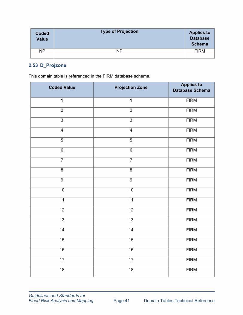
2.53 D_Projzone
This domain table is referenced in the FIRM database schema.
Coded Value Projection Zone Applies to Database Schema
1 1 FIRM
2 2 FIRM
3 3 FIRM
4 4 FIRM
5 5 FIRM
6 6 FIRM
7 7 FIRM
8 8 FIRM
9 9 FIRM
10 10 FIRM
11 11 FIRM
12 12 FIRM
13 13 FIRM
14 14 FIRM
15 15 FIRM
16 16 FIRM
17 17 FIRM
18 18 FIRM

Guidelines and Standards for Flood Risk Analysis and Mapping Page 42 Domain Tables Technical Reference
Coded Value Projection Zone Applies to Database Schema
19 19 FIRM
2111H 2111H FIRM
0101H 0101H FIRM
0102H 0102H FIRM
0201H 0201H FIRM
0202H 0202H FIRM
0203H 0203H FIRM
0401H 0401H FIRM
0402H 0402H FIRM
0403H 0403H FIRM
0404H 0404H FIRM
0405H 0405H FIRM
0406H 0406H FIRM
0501H 0501H FIRM
0502H 0502H FIRM
0503H 0503H FIRM
0600H 0600H FIRM
0700H 0700H FIRM
0901H 0901H FIRM
0902H 0902H FIRM
0903H 0903H FIRM
1001H 1001H FIRM
1002H 1002H FIRM

Guidelines and Standards for Flood Risk Analysis and Mapping Page 43 Domain Tables Technical Reference
Coded Value Projection Zone Applies to Database Schema
1101H 1101H FIRM
1102H 1102H FIRM
1103H 1103H FIRM
1201H 1201H FIRM
1202H 1202H FIRM
1301H 1301H FIRM
1302H 1302H FIRM
1501H 1501H FIRM
1502H 1502H FIRM
1601H 1601H FIRM
1602H 1602H FIRM
1701H 1701H FIRM
1702H 1702H FIRM
1801H 1801H FIRM
1802H 1802H FIRM
1900H 1900H FIRM
2001H 2001H FIRM
2002H 2002H FIRM
2111H 2111H FIRM
2112H 2112H FIRM
2113H 2113H FIRM
2301H 2301H FIRM
2302H 2302H FIRM

Applies to Coded Value Projection Zone Database Schema
2500H 2500H FIRM
2600H 2600H FIRM
2701H 2701H FIRM
2702H 2702H FIRM
2703H 2703H FIRM
2800H 2800H FIRM
2900H 2900H FIRM
3001H 3001H FIRM
3002H 3002H FIRM
3003H 3003H FIRM
3101H 3101H FIRM
3102H 3102H FIRM
3103H 3103H FIRM
3104H 3104H FIRM
3301H 3301H FIRM
3302H 3302H FIRM
3401H 3401H FIRM
3402H 3402H FIRM
3501H 3501H FIRM
3502H 3502H FIRM
3601H 3601H FIRM
3602H 3602H FIRM
3800H 3800H FIRM
Guidelines and Standards for Flood Risk Analysis and Mapping Page 44 Domain Tables Technical Reference
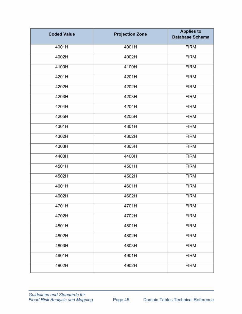
Guidelines and Standards for Flood Risk Analysis and Mapping Page 45 Domain Tables Technical Reference
Coded Value Projection Zone Applies to Database Schema
4001H 4001H FIRM
4002H 4002H FIRM
4100H 4100H FIRM
4201H 4201H FIRM 4202H 4202H FIRM
4203H 4203H FIRM
4204H 4204H FIRM
4205H 4205H FIRM
4301H 4301H FIRM
4302H 4302H FIRM
4303H 4303H FIRM
4400H 4400H FIRM
4501H 4501H FIRM
4502H 4502H FIRM
4601H 4601H FIRM
4602H 4602H FIRM
4701H 4701H FIRM
4702H 4702H FIRM
4801H 4801H FIRM
4802H 4802H FIRM
4803H 4803H FIRM
4901H 4901H FIRM
4902H 4902H FIRM

Guidelines and Standards for Flood Risk Analysis and Mapping Page 46 Domain Tables Technical Reference
Coded Value Projection Zone Applies to Database Schema
4903H 4903H FIRM
4904H 4904H FIRM
5101H 5101H FIRM
5102H 5102H FIRM
5103H 5103H FIRM
5104H 5104H FIRM
5105H 5105H FIRM
5200H 5200H FIRM
0101 0101 FIRM
0102 0102 FIRM
0201 0201 FIRM
0202 0202 FIRM
0203 0203 FIRM
0301 0301 FIRM
0302 0302 FIRM
0401 0401 FIRM
0402 0402 FIRM
0403 0403 FIRM
0404 0404 FIRM
0405 0405 FIRM
0406 0406 FIRM
0501 0501 FIRM
0502 0502 FIRM
Guidelines and Standards for Flood Risk Analysis and Mapping Page 47 Domain Tables Technical Reference
Coded Value Projection Zone Applies to Database Schema
0503 0503 FIRM
0600 0600 FIRM
0700 0700 FIRM
0901 0901 FIRM
0902 0902 FIRM
0903 0903 FIRM
1001 1001 FIRM
1002 1002 FIRM
1101 1101 FIRM
1102 1102 FIRM
1103 1103 FIRM
1201 1201 FIRM
1202 1202 FIRM
1301 1301 FIRM
1302 1302 FIRM
1401 1401 FIRM
1402 1402 FIRM
1501 1501 FIRM
1502 1502 FIRM
1600 1600 FIRM
1601 1601 FIRM
1602 1602 FIRM
1701 1701 FIRM

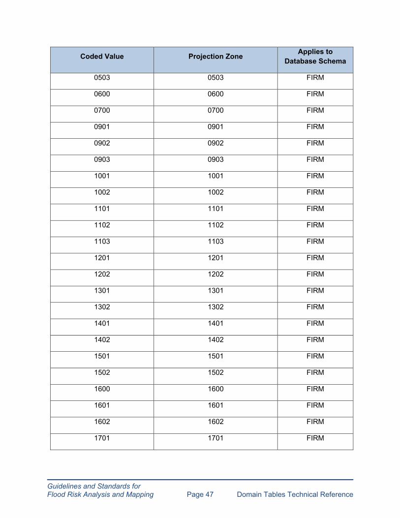
Guidelines and Standards for Flood Risk Analysis and Mapping Page 48 Domain Tables Technical Reference
Coded Value Projection Zone Applies to Database Schema
1702 1702 FIRM
1801 1801 FIRM
1802 1802 FIRM
1900 1900 FIRM
2001 2001 FIRM
2002 2002 FIRM
2111 2111 FIRM
2112 2112 FIRM
2113 2113 FIRM
2201 2201 FIRM
2202 2202 FIRM
2203 2203 FIRM
2301 2301 FIRM
2302 2302 FIRM
2401 2401 FIRM
2402 2402 FIRM
2403 2403 FIRM
2500 2500 FIRM
2600 2600 FIRM
2701 2701 FIRM
2702 2702 FIRM
2703 2703 FIRM
2800 2800 FIRM

Guidelines and Standards for Flood Risk Analysis and Mapping Page 49 Domain Tables Technical Reference
Coded Value Projection Zone Applies to Database Schema
2900 2900 FIRM
3001 3001 FIRM
3002 3002 FIRM
3003 3003 FIRM
3101 3101 FIRM
3102 3102 FIRM
3103 3103 FIRM
3104 3104 FIRM
3200 3200 FIRM
3301 3301 FIRM
3302 3302 FIRM
3401 3401 FIRM
3402 3402 FIRM
3501 3501 FIRM
3502 3502 FIRM
3601 3601 FIRM
3602 3602 FIRM
3701 3701 FIRM
3702 3702 FIRM
3800 3800 FIRM
3900 3900 FIRM
4001 4001 FIRM
4002 4002 FIRM

Guidelines and Standards for Flood Risk Analysis and Mapping Page 50 Domain Tables Technical Reference
Coded Value Projection Zone Applies to Database Schema
4100 4100 FIRM
4201 4201 FIRM
4202 4202 FIRM
4203 4203 FIRM
4204 4204 FIRM
4205 4205 FIRM
4301 4301 FIRM
4302 4302 FIRM
4303 4303 FIRM
4400 4400 FIRM
4501 4501 FIRM
4502 4502 FIRM
4601 4601 FIRM
4602 4602 FIRM
4701 4701 FIRM
4702 4702 FIRM
4801 4801 FIRM
4802 4802 FIRM
4803 4803 FIRM
4901 4901 FIRM
4902 4902 FIRM
4903 4903 FIRM
4904 4904 FIRM
Guidelines and Standards for Flood Risk Analysis and Mapping Page 51 Domain Tables Technical Reference
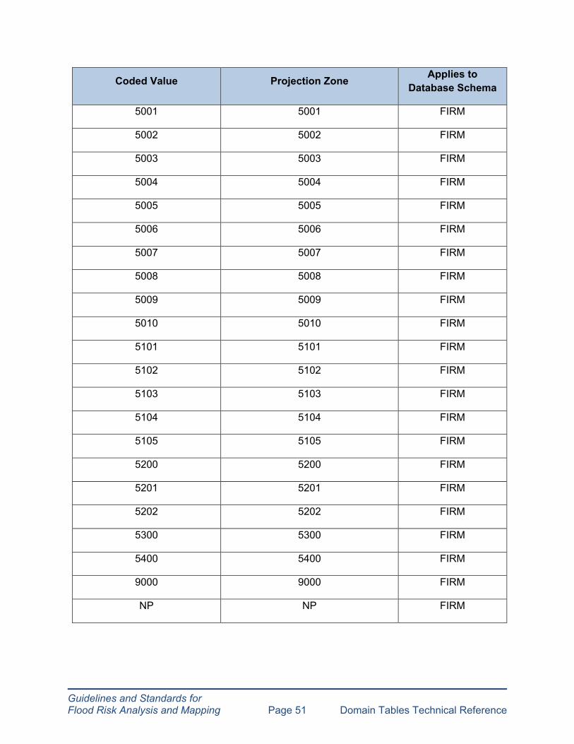
Coded Value Projection Zone Applies to Database Schema
5001 5001 FIRM
5002 5002 FIRM
5003 5003 FIRM
5004 5004 FIRM
5005 5005 FIRM
5006 5006 FIRM
5007 5007 FIRM
5008 5008 FIRM
5009 5009 FIRM
5010 5010 FIRM
5101 5101 FIRM
5102 5102 FIRM
5103 5103 FIRM
5104 5104 FIRM
5105 5105 FIRM
5200 5200 FIRM
5201 5201 FIRM
5202 5202 FIRM
5300 5300 FIRM
5400 5400 FIRM
9000 9000 FIRM
NP NP FIRM

Guidelines and Standards for Flood Risk Analysis and Mapping Page 52 Domain Tables Technical Reference
2.54 D_Quad_Corner
This domain table is referenced in the FIRM database schema.
Coded Value Quad Corner Applies to Database Schema
NE NE FIRM NW NW FIRM SE SE FIRM SW SW FIRM
2.55 D_Release_Typ
This domain table is referenced in the FRD database schema.
Coded Value Type of Release Applies to Database Schema
P Piping FRD
O Overtop FRD
G Gate Failure FRD
NP NP FRD
2.56 D_Reservoir_Cond
This domain table is referenced in the FRD database schema.
Coded Value Type of Reservoir Conditions Applies to Database Schema
F Full FRD N Normal Pool FRD A Auxiliary Spillway FRD P Primary Spillway FRD W Without Dam FRD NP NP FRD

Guidelines and Standards for Flood Risk Analysis and Mapping Page 53 Domain Tables Technical Reference
2.57 D_Runup_Mdl
This domain table is referenced in the FIRM and FRD database schemas.
Coded Value Type of Runup Model Applies to Database Schema
1010 ACES 1.07 (1992) FIRM, FRD 1015 CEM – OTHER (2003) FIRM, FRD 1020 CHAMP / RUNUP 2.0 (2007) FIRM, FRD 1080 DIM FIRM, FRD 1030 EROSION (1998) FRD 1040 GLWRM (1992) FRD 9000 OTHER FIRM, FRD 1050 RUNUP 2.0 (1990) FIRM, FRD 1070 SPM (USACE 1984) FIRM, FRD 1060 TAW Method FIRM, FRD
2.58 D_Scale
This domain table is referenced in the FIRM database schema.
Coded Value FIRM Panel Scale Applies to Database Schema
1000 6000 FIRM 1010 12000 FIRM 1020 24000 FIRM 2000 10000 FIRM
2.59 D_SFHA_FLDWY
This domain table is referenced in the FRD database schema.
Coded Value Type of FRD Floodway Applies to Database Schema
SFHA Special Flood Hazard Area FRD
FLDWY Floodway FRD
NONSFHA Non-Special Flood Hazard Area FRD
CHHA Coastal High Hazard Area FRD
NP NP FRD

Guidelines and Standards for Flood Risk Analysis and Mapping Page 54 Domain Tables Technical Reference
2.60 D_Shr_Typ
This domain table is referenced in the FIRM database schema.
Coded Value Type of Shoreline Applies to Database Schema
1000 Sandy Beach-Small Dune FIRM 1010 Sandy Beach-Large Dune FIRM 1020 Erodible Bluff FIRM 1030 Non-Erodible Bluff FIRM 1040 Shore Protection Structure FIRM 1050 Wetland FIRM
2.61 D_State_FIPS
This domain table is referenced in the FIRM and FRD database schemas.
Coded Value FIRM Description FRD Description Applies to Database Schema
01 01 01 - Alabama FIRM, FRD 02 02 02 - Alaska FIRM, FRD 04 04 04 - Arizona FIRM, FRD 05 05 05 - Arkansas FIRM, FRD 06 06 06 - California FIRM, FRD 08 08 08 - Colorado FIRM, FRD 09 09 09 - Connecticut FIRM, FRD 10 10 10 - Delaware FIRM, FRD 11 11 11 - District of Columbia FIRM, FRD 12 12 12 - Florida FIRM, FRD 13 13 13 - Georgia FIRM, FRD 15 15 15 - Hawaii FIRM, FRD 16 16 16 - Idaho FIRM, FRD 17 17 17 - Illinois FIRM, FRD 18 18 18 - Indiana FIRM, FRD 19 19 19 - Iowa FIRM, FRD 20 20 20 - Kansas FIRM, FRD 21 21 21 - Kentucky FIRM, FRD 22 22 22 - Louisiana FIRM, FRD 23 23 23 - Maine FIRM, FRD 24 24 24 - Maryland FIRM, FRD 25 25 25 - Massachusetts FIRM, FRD 26 26 26 - Michigan FIRM, FRD

Guidelines and Standards for Flood Risk Analysis and Mapping Page 55 Domain Tables Technical Reference
Coded Value FIRM Description FRD Description Applies to Database Schema
27 27 27 - Minnesota FIRM, FRD 28 28 28 - Mississippi FIRM, FRD 29 29 29 - Missouri FIRM, FRD 30 30 30 - Montana FIRM, FRD 31 31 31 - Nebraska FIRM, FRD 32 32 32 - Nevada FIRM, FRD 33 33 33 - New Hampshire FIRM, FRD 34 34 34 - New Jersey FIRM, FRD 35 35 35 - New Mexico FIRM, FRD 36 36 36 - New York FIRM, FRD 37 37 37 - North Carolina FIRM, FRD 38 38 38 - North Dakota FIRM, FRD 39 39 39 - Ohio FIRM, FRD 40 40 40 - Oklahoma FIRM, FRD 41 41 41 - Oregon FIRM, FRD 42 42 42 - Pennsylvania FIRM, FRD 44 44 44 - Rhode Island FIRM, FRD 45 45 45 - South Carolina FIRM, FRD 46 46 46 - South Dakota FIRM, FRD 47 47 47 - Tennessee FIRM, FRD 48 48 48 - Texas FIRM, FRD 49 49 49 - Utah FIRM, FRD 50 50 50 - Vermont FIRM, FRD 51 51 51 - Virginia FIRM, FRD 53 53 53 - Washington FIRM, FRD 54 54 54 - West Virginia FIRM, FRD 55 55 55 - Wisconsin FIRM, FRD 56 56 56 - Wyoming FIRM, FRD 60 60 60 - American Samoa FIRM, FRD 64 64 64 - Micronesia FIRM, FRD 66 66 66 - Guam FIRM, FRD 68 68 68 - Marshall Islands FIRM, FRD 69 69 69 - Northern Mariana Islands FIRM, FRD 70 70 70 - Palau FIRM, FRD 72 72 72 - Puerto Rico FIRM, FRD 74 74 74 – U.S. Minor Islands FIRM, FRD 78 78 78 - Virgin Islands FIRM, FRD
Guidelines and Standards for Flood Risk Analysis and Mapping Page 56 Domain Tables Technical Reference
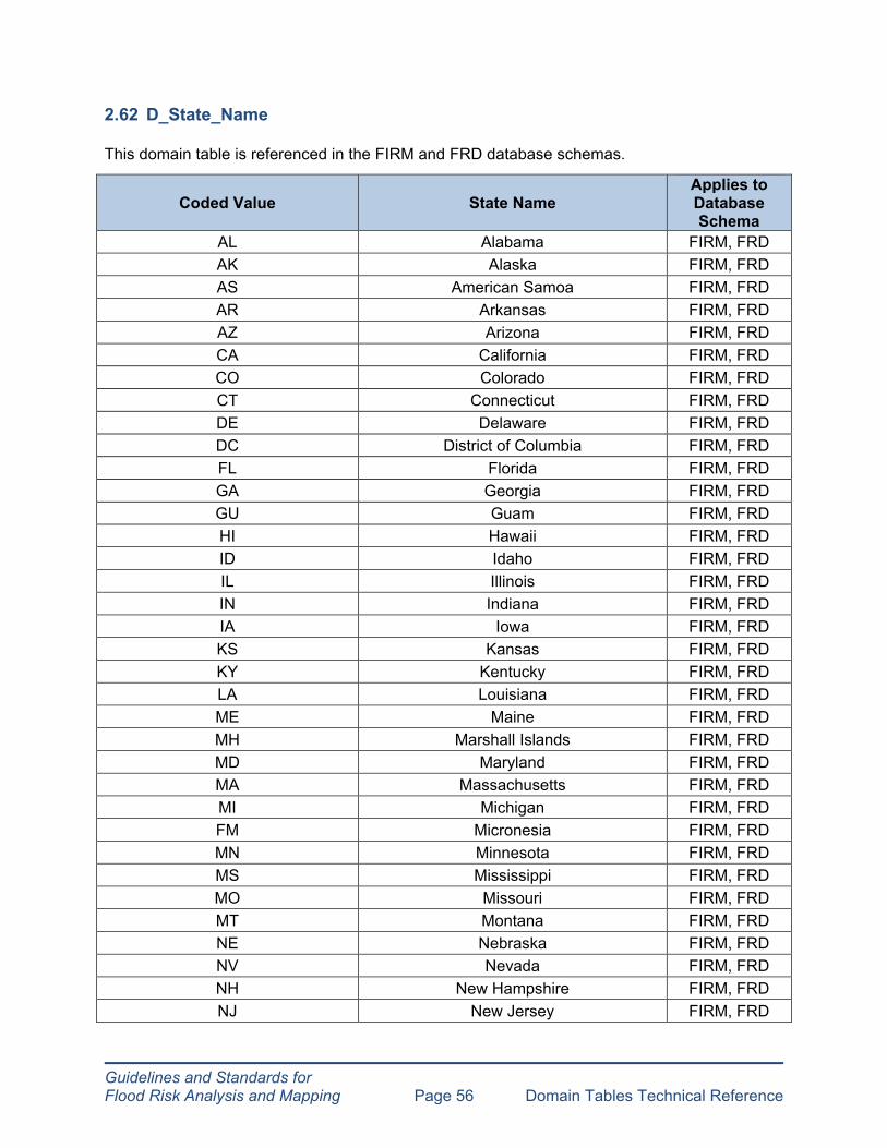
2.62 D_State_Name
This domain table is referenced in the FIRM and FRD database schemas.
Coded Value State Name Applies to Database Schema
AL Alabama FIRM, FRD AK Alaska FIRM, FRD AS American Samoa FIRM, FRD AR Arkansas FIRM, FRD AZ Arizona FIRM, FRD CA California FIRM, FRD CO Colorado FIRM, FRD CT Connecticut FIRM, FRD DE Delaware FIRM, FRD DC District of Columbia FIRM, FRD FL Florida FIRM, FRD GA Georgia FIRM, FRD GU Guam FIRM, FRD HI Hawaii FIRM, FRD ID Idaho FIRM, FRD IL Illinois FIRM, FRD IN Indiana FIRM, FRD IA Iowa FIRM, FRD KS Kansas FIRM, FRD KY Kentucky FIRM, FRD LA Louisiana FIRM, FRD ME Maine FIRM, FRD MH Marshall Islands FIRM, FRD MD Maryland FIRM, FRD MA Massachusetts FIRM, FRD MI Michigan FIRM, FRD FM Micronesia FIRM, FRD MN Minnesota FIRM, FRD MS Mississippi FIRM, FRD MO Missouri FIRM, FRD MT Montana FIRM, FRD NE Nebraska FIRM, FRD NV Nevada FIRM, FRD NH New Hampshire FIRM, FRD NJ New Jersey FIRM, FRD

Guidelines and Standards for Flood Risk Analysis and Mapping Page 57 Domain Tables Technical Reference
Coded Value State Name Applies to Database Schema
NM New Mexico FIRM, FRD NY New York FIRM, FRD NC North Carolina FIRM, FRD ND North Dakota FIRM, FRD MP Northern Mariana Islands FIRM, FRD OH Ohio FIRM, FRD OK Oklahoma FIRM, FRD OR Oregon FIRM, FRD PW Palau FIRM, FRD PA Pennsylvania FIRM, FRD PR Puerto Rico FIRM, FRD RI Rhode Island FIRM, FRD SC South Carolina FIRM, FRD SD South Dakota FIRM, FRD TN Tennessee FIRM, FRD TX Texas FIRM, FRD UM U.S. Minor Islands FIRM, FRD UT Utah FIRM, FRD VT Vermont FIRM, FRD VA Virginia FIRM, FRD VI Virgin Islands FIRM, FRD
WA Washington FIRM, FRD WV West Virginia FIRM, FRD WI Wisconsin FIRM, FRD WY Wyoming FIRM, FRD NP NP FIRM, FRD
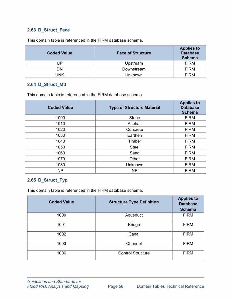
Guidelines and Standards for Flood Risk Analysis and Mapping Page 58 Domain Tables Technical Reference
2.63 D_Struct_Face
This domain table is referenced in the FIRM database schema.
Coded Value Face of Structure Applies to Database Schema
UP Upstream FIRM DN Downstream FIRM
UNK Unknown FIRM
2.64 D_Struct_Mtl
This domain table is referenced in the FIRM database schema.
Coded Value Type of Structure Material Applies to Database Schema
1000 Stone FIRM 1010 Asphalt FIRM 1020 Concrete FIRM 1030 Earthen FIRM 1040 Timber FIRM 1050 Steel FIRM 1060 Sand FIRM 1070 Other FIRM 1080 Unknown FIRM NP NP FIRM
2.65 D_Struct_Typ
This domain table is referenced in the FIRM database schema.
Coded Value Structure Type Definition Applies to Database Schema
1000 Aqueduct FIRM
1001 Bridge FIRM
1002 Canal FIRM
1003 Channel FIRM
1006 Control Structure FIRM

Guidelines and Standards for Flood Risk Analysis and Mapping Page 59 Domain Tables Technical Reference
Coded Value Structure Type Definition Applies to Database Schema
1007 Culvert FIRM
1010 Dam FIRM
1011 Dike FIRM
1012 Dock FIRM
1013 Drop Structure FIRM
1014 Energy Dissipater FIRM
1015 Fish Ladder FIRM
1017 Flume FIRM
1018 Footbridge FIRM
1019 Gate FIRM
1020 Jetty FIRM
1021 Levee FIRM
1022 Lock FIRM
1023 Penstock FIRM
1024 Pier FIRM
1025 Pump Station FIRM
1026 Seawall FIRM
1027 Side Weir Structure FIRM
1028 Storm Sewer FIRM
1029 Utility Crossing FIRM
1030 Weir FIRM
1031 Wing Wall FIRM
1033 0.2 PCT Annual Chance Flood Discharge Contained in Structure FIRM

Guidelines and Standards for Flood Risk Analysis and Mapping Page 60 Domain Tables Technical Reference
Coded Value Structure Type Definition Applies to Database Schema
1032 1 PCT Annual Chance Flood Discharge Contained in Structure FIRM
1036 Floodway Contained in Structure FIRM
1037 Pipeline FIRM
1038 Retaining Wall FIRM
1039 Revetment FIRM
1040 Siphon FIRM
9000 Other / Misc. Structure FIRM
NP NP FIRM
2.66 D_Study_Mth
Coded Value Study Method When Used Applies to Database Schema
1000 New H&H New fully detailed modeling FIRM, FRD
1010 BLE TIER A Auto placed cross sections, structures not included FIRM, FRD
1020 BLE TIER B Intelligently placed cross sections, structures not included FIRM, FRD
1030 BLE TIER C Cross sections reviewed by structures included
engineer, FIRM, FRD
1040 BLE TIER D Cross sections reviewed by engineer, structures with opening information
FIRM, FRD

Guidelines and Standards for Flood Risk Analysis and Mapping Page 61 Domain Tables Technical Reference
Coded Value Study Method When Used Applies to Database Schema
1050 BLE TIER E
Cross sections reviewed by engineer and with channel bathymetry, structures from field survey, as-builts, or measured in field
FIRM, FRD
1060 LSAE Large Scale Automated Engineering FIRM, FRD
1100 REDELINEATION Existing studies remapped on new topographic data FIRM, FRD
1200 DIGITAL CONVERSION
Existing studies digitized from existing scanned panels FIRM, FRD
9000 OTHER OTHER FRD
NP NP NP; unshaded-X zones FIRM
2.67 D_Study_Prefix
This domain table is referenced in the FIRM and FRD database schemas.
Coded Value Type of Prefix Value Applies to Database Schema
0100 Borough of FIRM, FRD 0200 City and County of FIRM, FRD 0300 City of FIRM, FRD 0400 Municipality of FIRM, FRD 0500 Town of FIRM, FRD 0600 Township of FIRM, FRD 0700 Village of FIRM, FRD 0800 Town and Village of FIRM, FRD 9000 Other FIRM, FRD

Guidelines and Standards for Flood Risk Analysis and Mapping Page 62 Domain Tables Technical Reference
2.68 D_Study_Typ
This domain table is referenced in the FIRM and FRD database schemas.
Coded Value Type of Study When Used Applies to Database Schema
1030 BLE available but unpublished
Base Level Engineering data are available but zones and BFEs are
not published on FIRM FIRM, FRD
1000 SFHA without BFE Such as A zones without BFEs or water surface elevations FIRM, FRD
1040 SFHA with unpublished BFE
Such as A zones with BFEs or water surface elevations calculated but not
published in FIS Report FIRM, FRD
1010 SFHA with BFE published only in FIS
Such as A zones with BFEs or water surface elevations published only in
FIS Report FIRM, FRD
1050 SFHA with BFE no floodway
Such as AE or VE zones with regulatory water surface elevations
or depths but no floodway; or shaded-X zones that are associated
with this type of study
FIRM, FRD
1060 SFHA with BFE and floodway
Such as AE or VE zones with regulatory water surface elevations
and a regulatory floodway; or shaded-X zones that are associated
with this type of study
FIRM, FRD
1070 Shaded Zone X with depths less than 1’
Such as Zone X with depths less than 1’ FIRM, FRD
9000 OTHER OTHER FRD
NP NP NP; unshaded-X zones FIRM
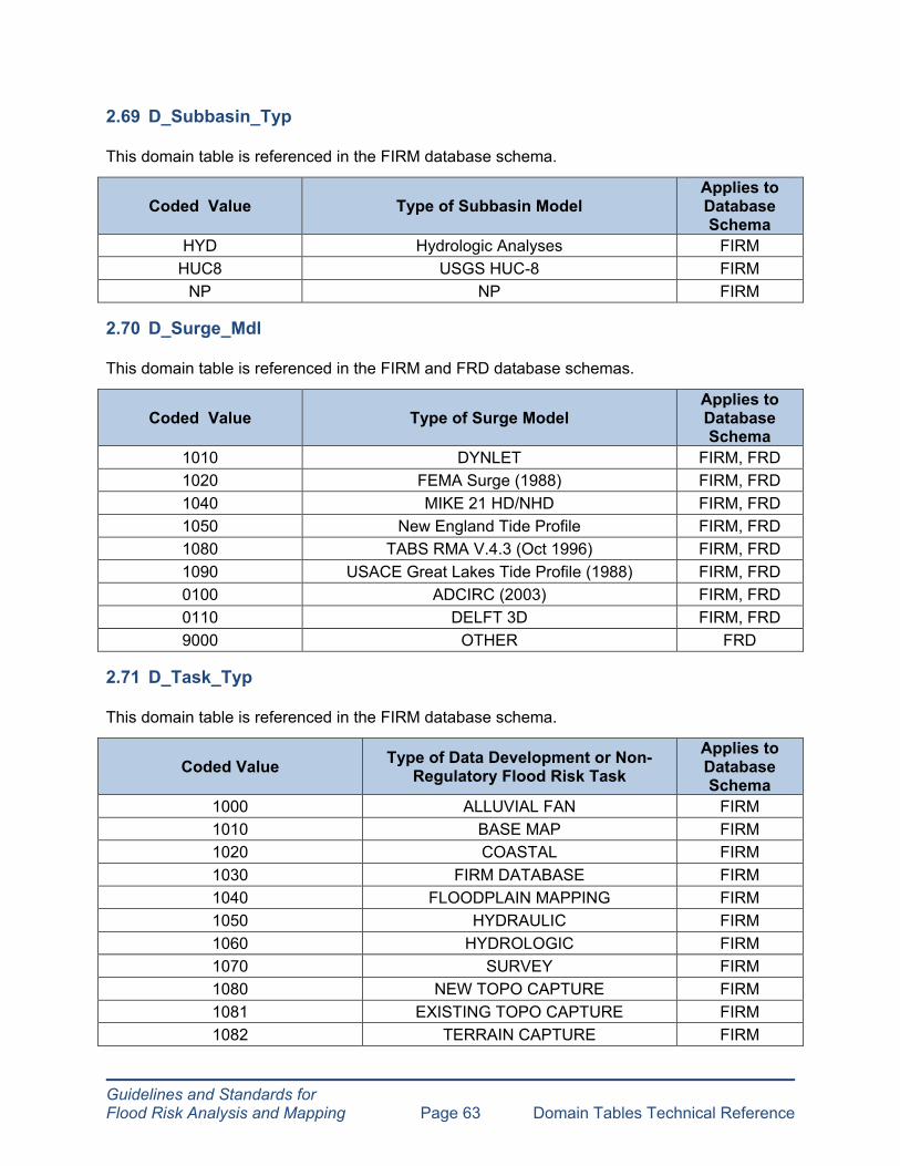
Guidelines and Standards for Flood Risk Analysis and Mapping Page 63 Domain Tables Technical Reference
2.69 D_Subbasin_Typ
This domain table is referenced in the FIRM database schema.
Coded Value Type of Subbasin Model Applies to Database Schema
HYD Hydrologic Analyses FIRM HUC8 USGS HUC-8 FIRM
NP NP FIRM
2.70 D_Surge_Mdl
This domain table is referenced in the FIRM and FRD database schemas.
Coded Value Type of Surge Model Applies to Database Schema
1010 DYNLET FIRM, FRD 1020 FEMA Surge (1988) FIRM, FRD 1040 MIKE 21 HD/NHD FIRM, FRD 1050 New England Tide Profile FIRM, FRD 1080 TABS RMA V.4.3 (Oct 1996) FIRM, FRD 1090 USACE Great Lakes Tide Profile (1988) FIRM, FRD 0100 ADCIRC (2003) FIRM, FRD 0110 DELFT 3D FIRM, FRD 9000 OTHER FRD
2.71 D_Task_Typ
This domain table is referenced in the FIRM database schema.
Coded Value Type of Data Development or Non-Regulatory Flood Risk Task
Applies to Database Schema
1000 ALLUVIAL FAN FIRM 1010 BASE MAP FIRM 1020 COASTAL FIRM 1030 FIRM DATABASE FIRM 1040 FLOODPLAIN MAPPING FIRM 1050 HYDRAULIC FIRM 1060 HYDROLOGIC FIRM 1070 SURVEY FIRM 1080 NEW TOPO CAPTURE FIRM 1081 EXISTING TOPO CAPTURE FIRM 1082 TERRAIN CAPTURE FIRM

Guidelines and Standards for Flood Risk Analysis and Mapping Page 64 Domain Tables Technical Reference
Coded Value Type of Data Development or Non-Regulatory Flood Risk Task
Applies to Database Schema
1090 DISCOVERY FIRM 1100 FLOOD RISK ASSESSMENT FIRM 1200 LOMR FIRM NP NP FIRM
2.72 D_Time_Units
This domain table is referenced in the FIRM database schema.
Coded Value Type of Time Unit Applies to Database Schema
1000 DAYS FIRM 1010 HOURS FIRM 1020 MINUTES FIRM 1030 MONTHS FIRM 1040 SECONDS FIRM 1050 WEEKS FIRM 1060 YEARS FIRM
2.73 D_TrueFalse
This domain table is referenced in the FIRM and FRD database schemas.
Coded Value FRD Description FIRM Description Applies to Database Schema
T True (Yes) T FIRM, FRD F False (No) F FIRM, FRD U Unknown U FIRM, FRD
2.74 D_TsctBasln_Typ
This domain table is referenced in the FIRM database schema.
Coded Value Type of Transect Baseline Source Applies to Database Schema
1000 Zero Foot Contour Field Survey FIRM 1010 Zero Foot Contour LiDAR / Shoals FIRM
1020 Zero Foot Contour Referenced to Tidal Datum FIRM
9000 Other Source FIRM NP NP FIRM
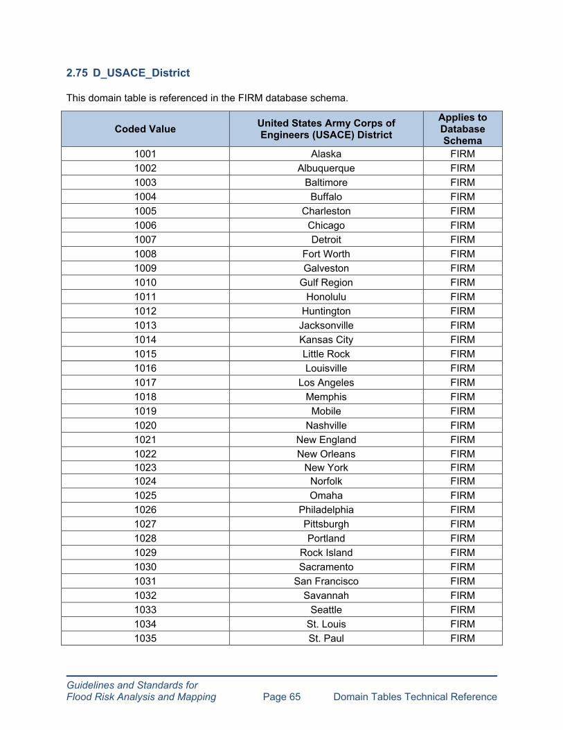
Guidelines and Standards for Flood Risk Analysis and Mapping Page 65 Domain Tables Technical Reference
2.75 D_USACE_District
This domain table is referenced in the FIRM database schema.
Coded Value United States Army Corps of Engineers (USACE) District
Applies to Database Schema
1001 Alaska FIRM 1002 Albuquerque FIRM 1003 Baltimore FIRM 1004 Buffalo FIRM 1005 Charleston FIRM 1006 Chicago FIRM 1007 Detroit FIRM 1008 Fort Worth FIRM 1009 Galveston FIRM 1010 Gulf Region FIRM 1011 Honolulu FIRM 1012 Huntington FIRM 1013 Jacksonville FIRM 1014 Kansas City FIRM 1015 Little Rock FIRM 1016 Louisville FIRM 1017 Los Angeles FIRM 1018 Memphis FIRM 1019 Mobile FIRM 1020 Nashville FIRM 1021 New England FIRM 1022 New Orleans FIRM 1023 New York FIRM 1024 Norfolk FIRM 1025 Omaha FIRM 1026 Philadelphia FIRM 1027 Pittsburgh FIRM 1028 Portland FIRM 1029 Rock Island FIRM 1030 Sacramento FIRM 1031 San Francisco FIRM 1032 Savannah FIRM 1033 Seattle FIRM 1034 St. Louis FIRM 1035 St. Paul FIRM

Coded Value Type of Velocity Unit Applies to Database Schema
1000 Centimeters / Day FIRM 1010 Centimeters / Hour FIRM 1020 Feet / Second FIRM 1030 Inches / Day FIRM 1040 Inches / Hour FIRM 1050 Meters / Second FIRM 1060 Micrometers / Second FIRM 1070 Millimeters / Day FIRM 1080 Millimeters / Hour FIRM
Guidelines and Standards for Flood Risk Analysis and Mapping Page 66 Domain Tables Technical Reference
Coded Value United States Army Corps of Engineers (USACE) District
Applies to Database Schema
1036 Tulsa FIRM 1037 Vicksburg FIRM 1038 Walla Walla FIRM 1039 Wilmington FIRM NP NP FIRM
2.76 D_V_Datum
This domain table is referenced in the FIRM and FRD database schemas.
Coded Value FRD Description Type of Vertical Datum FIRM Description
Applies to Database Schema
MSL Mean Sea Level MSL FIRM, FRD
NAVD88 North American Vertical Datum 1988 NAVD88 FIRM, FRD
North American NGVD29 Geodetic Vertical NGVD29 FIRM, FRD
Datum 1929 TIDAL Local Tidal Datum LOCAL TIDAL DATUM FIRM, FRD
MLLW Mean Lower Low Water Datum MLLW FIRM, FRD
MLW Mean Low Water Datum MLW FIRM, FRD
NP NP NP FIRM NP – for legacy NFHL records only. All new studies must specify vertical datum.
2.77 D_Velocity_Units
This domain table is referenced in the FIRM database schema.

Guidelines and Standards for Flood Risk Analysis and Mapping Page 67 Domain Tables Technical Reference
Coded Value Type of Velocity Unit Applies to Database Schema
NP NP FIRM
2.78 D_VZone
This domain table is referenced in the FIRM database schema.
Coded Value Type of V Zone Applies to Database Schema
1060 Breaking Wave Ht FIRM 1050 High Velocity Flow FIRM 1030 Runup FIRM 1010 Wave Overtopping Splash Zone FIRM 1020 PFD FIRM
2.79 D_Wave_Haz
This domain table is referenced in the FRD database schema.
Coded Value Type of Wave Hazard Applies to Database Schema
HIGH High FRD MOD Moderate FRD MIN Minimal FRD NP NP FRD
2.80 D_Wave_Mdl
This domain table is referenced in the FIRM and FRD database schemas.
Coded Value Type of Wave Model Applies to Database Schema
1020 MIKE 21 (OSW) FIRM, FRD 1030 MIKE 21 (NSW) FIRM, FRD 1040 RCPWAVE (1986) FIRM, FRD 1050 WHAFIS 3.0 (1988) FIRM, FRD 1060 WHAFIS 3.0 GL (1983) FIRM, FRD 1010 DELFT 3D FIRM, FRD 1070 STWAVE (Latest Version) FIRM, FRD 1080 SWAN (2008) FIRM, FRD 1065 WHAFIS 4.0 (2007) FIRM, FRD

Guidelines and Standards for Flood Risk Analysis and Mapping Page 68 Domain Tables Technical Reference
Coded Value Type of Wave Model Applies to Database Schema
9000 OTHER FRD
2.81 D_XS_Ln_Typ
This domain table is referenced in the FIRM database schema.
Coded Value
Type of Cross Section Description
Applies to Database Schema
When Used?
1010 LETTERED, MAPPED FIRM Traditional Lettered XS, FDTs, Profiles
1020 NOT LETTERED, MAPPED FIRM
Modeled XSs used for Base Flood Elevation (BFE) values on FIRM panels, not shown on FDTs or
Profiles, shown but not lettered on panels
1030 NOT LETTERED, NOT MAPPED FIRM
Model Backup in the FIRM Database, including unused XSs adjacent to bridges, too densely
spaced, or modeled Zone A.
2.82 D_Zone
This domain table is referenced in the FIRM and FRD database schemas.
Coded Value Type of Flood Zone Applies to Database Schema
A A FIRM, FRD A99 A99 FIRM, FRD AE AE FIRM, FRD AH AH FIRM, FRD AO AO FIRM, FRD AR AR FIRM, FRD ANI AREA NOT INCLUDED FIRM, FRD D D FIRM, FRD
NP NP – NOT POPULATED FRD OW OPEN WATER FIRM, FRD V V FIRM, FRD
VE VE FIRM, FRD X X FIRM, FRD
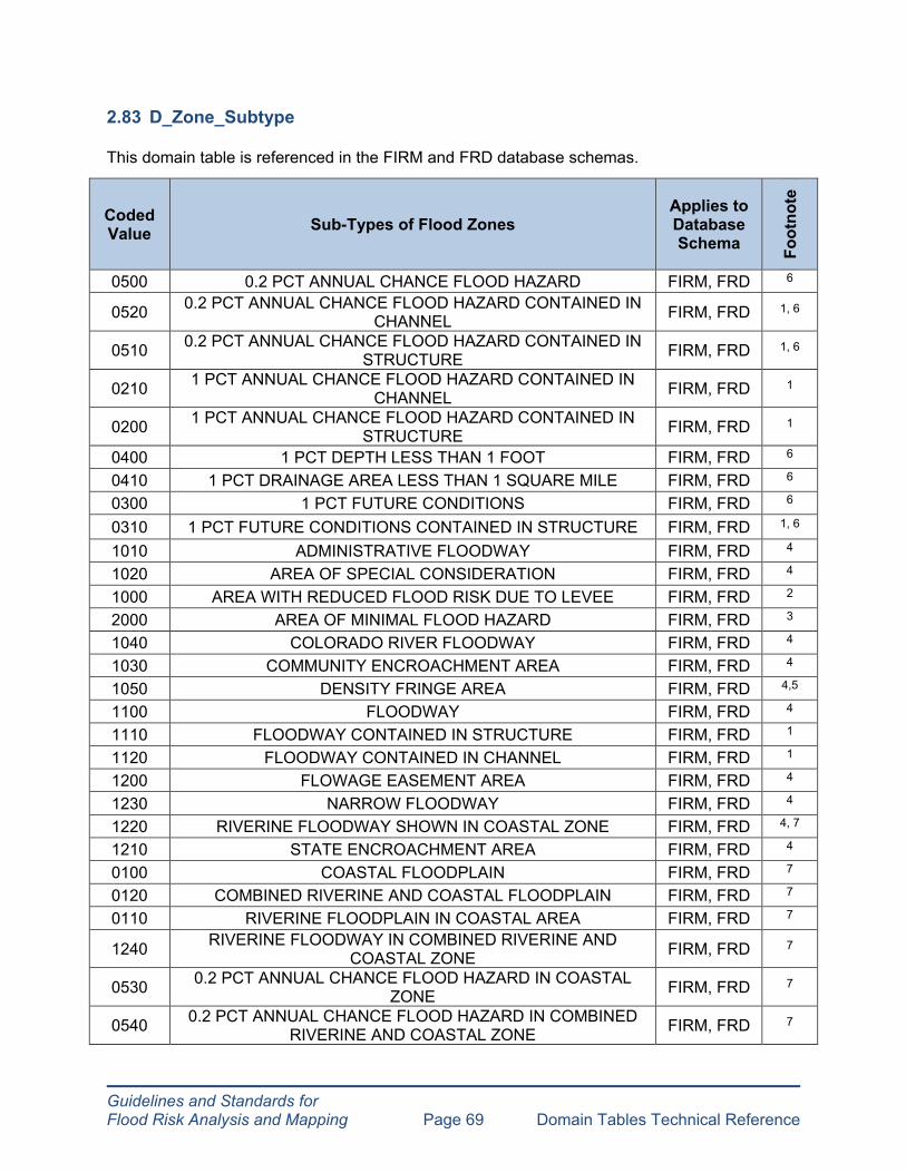
Guidelines and Standards for Flood Risk Analysis and Mapping Page 69 Domain Tables Technical Reference
2.83 D_Zone_Subtype
This domain table is referenced in the FIRM and FRD database schemas.
Coded Value Sub-Types of Flood Zones
Applies to Database Schema Fo
otno
te
0500 0.2 PCT ANNUAL CHANCE FLOOD HAZARD FIRM, FRD 6
0520 0.2 PCT ANNUAL CHANCE FLOOD HAZARD CONTAINED IN CHANNEL FIRM, FRD 1, 6
0510 0.2 PCT ANNUAL CHANCE FLOOD HAZARD CONTAINED IN STRUCTURE FIRM, FRD 1, 6
0210 1 PCT ANNUAL CHANCE FLOOD HAZARD CONTAINED IN CHANNEL FIRM, FRD 1
0200 1 PCT ANNUAL CHANCE FLOOD HAZARD CONTAINED IN STRUCTURE FIRM, FRD 1
0400 1 PCT DEPTH LESS THAN 1 FOOT FIRM, FRD 6
0410 1 PCT DRAINAGE AREA LESS THAN 1 SQUARE MILE FIRM, FRD 6
0300 1 PCT FUTURE CONDITIONS FIRM, FRD 6
0310 1 PCT FUTURE CONDITIONS CONTAINED IN STRUCTURE FIRM, FRD 1, 6
1010 ADMINISTRATIVE FLOODWAY FIRM, FRD 4
1020 AREA OF SPECIAL CONSIDERATION FIRM, FRD 4
1000 AREA WITH REDUCED FLOOD RISK DUE TO LEVEE FIRM, FRD 2
2000 AREA OF MINIMAL FLOOD HAZARD FIRM, FRD 3
1040 COLORADO RIVER FLOODWAY FIRM, FRD 4
1030 COMMUNITY ENCROACHMENT AREA FIRM, FRD 4
1050 DENSITY FRINGE AREA FIRM, FRD 4,5
1100 FLOODWAY FIRM, FRD 4
1110 FLOODWAY CONTAINED IN STRUCTURE FIRM, FRD 1
1120 FLOODWAY CONTAINED IN CHANNEL FIRM, FRD 1
1200 FLOWAGE EASEMENT AREA FIRM, FRD 4
1230 NARROW FLOODWAY FIRM, FRD 4
1220 RIVERINE FLOODWAY SHOWN IN COASTAL ZONE FIRM, FRD 4, 7
1210 STATE ENCROACHMENT AREA FIRM, FRD 4
0100 COASTAL FLOODPLAIN FIRM, FRD 7
0120 COMBINED RIVERINE AND COASTAL FLOODPLAIN FIRM, FRD 7
0110 RIVERINE FLOODPLAIN IN COASTAL AREA FIRM, FRD 7
1240 RIVERINE FLOODWAY IN COMBINED RIVERINE AND COASTAL ZONE FIRM, FRD 7
0530 0.2 PCT ANNUAL CHANCE FLOOD HAZARD IN COASTAL ZONE FIRM, FRD 7
0540 0.2 PCT ANNUAL CHANCE FLOOD HAZARD IN COMBINED RIVERINE AND COASTAL ZONE FIRM, FRD 7
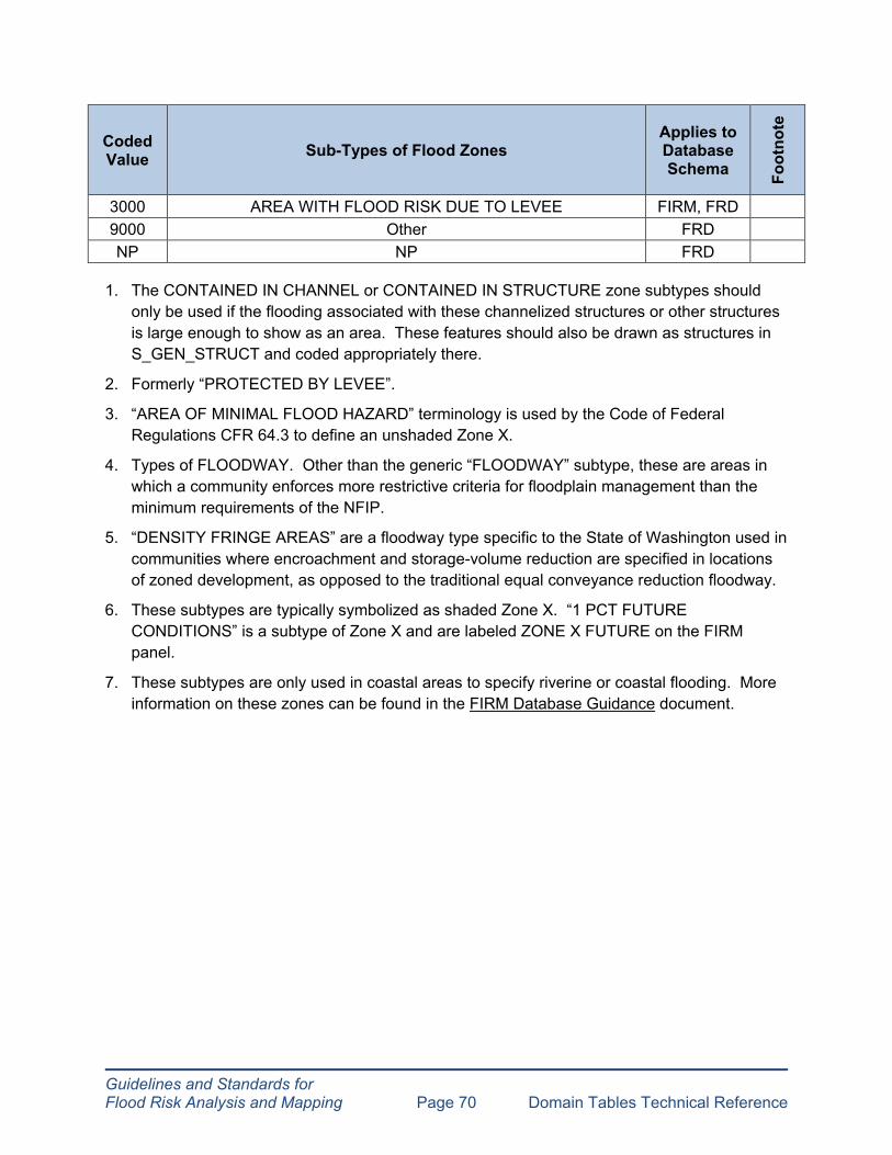
Guidelines and Standards for Flood Risk Analysis and Mapping Page 70 Domain Tables Technical Reference
Coded Value Sub-Types of Flood Zones
Applies to Database Schema Fo
otno
te
3000 AREA WITH FLOOD RISK DUE TO LEVEE FIRM, FRD 9000 Other FRD NP NP FRD
1. The CONTAINED IN CHANNEL or CONTAINED IN STRUCTURE zone subtypes should only be used if the flooding associated with these channelized structures or other structures is large enough to show as an area. These features should also be drawn as structures in S_GEN_STRUCT and coded appropriately there.
2. Formerly “PROTECTED BY LEVEE”.
3. “AREA OF MINIMAL FLOOD HAZARD” terminology is used by the Code of Federal Regulations CFR 64.3 to define an unshaded Zone X.
4. Types of FLOODWAY. Other than the generic “FLOODWAY” subtype, these are areas in which a community enforces more restrictive criteria for floodplain management than the minimum requirements of the NFIP.
5. “DENSITY FRINGE AREAS” are a floodway type specific to the State of Washington used in communities where encroachment and storage-volume reduction are specified in locations of zoned development, as opposed to the traditional equal conveyance reduction floodway.
6. These subtypes are typically symbolized as shaded Zone X. “1 PCT FUTURE CONDITIONS” is a subtype of Zone X and are labeled ZONE X FUTURE on the FIRM panel.
7. These subtypes are only used in coastal areas to specify riverine or coastal flooding. More information on these zones can be found in the FIRM Database Guidance document.