duration-aware data collection in uav-aided mobile sensor
TRANSCRIPT
HAL Id: hal-03185684https://hal.archives-ouvertes.fr/hal-03185684
Submitted on 30 Mar 2021
HAL is a multi-disciplinary open accessarchive for the deposit and dissemination of sci-entific research documents, whether they are pub-lished or not. The documents may come fromteaching and research institutions in France orabroad, or from public or private research centers.
L’archive ouverte pluridisciplinaire HAL, estdestinée au dépôt et à la diffusion de documentsscientifiques de niveau recherche, publiés ou non,émanant des établissements d’enseignement et derecherche français ou étrangers, des laboratoirespublics ou privés.
Duration-aware Data Collection in UAV-aided MobileSensor Networks
Xiaoyan Ma, Tianyi Liu, Rahim Kacimi, Riadh Dhaou, Song Liu
To cite this version:Xiaoyan Ma, Tianyi Liu, Rahim Kacimi, Riadh Dhaou, Song Liu. Duration-aware Data Collection inUAV-aided Mobile Sensor Networks. International Wireless Communications and Mobile ComputingConference (IWCMC 2021), IEEE Communications Society, Jun 2021, Harbin (Virtually), China.�hal-03185684�
Duration-aware Data Collection in UAV-aidedMobile Sensor Networks
Xiaoyan Ma 1, Tianyi Liu 2, Rahim Kacimi 3, Riadh Dhaou 4 and Song Liu 1
1 College of Architecture and Urban Planning, Tongji University, Shanghai, China; {xiaoyan ma, liusong5}@tongji.edu.cn2 School of Aerospace Engineering and Applied Mechanics, Tongji University, Shanghai, China; [email protected]
3 IRIT-UPS, Toulouse University, Toulouse, France; [email protected] IRIT-ENSEEIHT, Toulouse University, Toulouse, France; [email protected]
Abstract—Unmanned Aerial Vehicle (UAV)-aided Wireless Sen-sor Network (WSN) has been received increasing attentionsin recent years due to its tremendous applications in manyfields. The high dynamic topology in such network brings newcommunication challenges. In this paper, we address on thedynamic parameters, including the velocity and flying heightof the UAV, the sensors velocities, and its real-time location,which affect the topology and influence the communicationperformance of the system. We introduce the contact-durationto mathematically integrate these parameters and to measurethe transmission opportunity between the mobile node and theUAV and formulate the data collection issue as an optimizationproblem with the objectives of jointly maximizing the numberof collected packets and the number of nodes that participatethe communications with the UAV. Furthermore, we propose anopportunity-optimal frame selection algorithm, named as OFSalgorithm, to increase the communication opportunities of thenodes, thereby, the data collection performance of the networkwas enhanced. Through extensive simulations based on simulatedmovement and real experiments, we evaluate the effectiveness ofthe proposed mechanisms under different configurations. Theresults present that the proposed mechanisms perform well onenhancing the transmission opportunity of the mobile nodes andthe data collection performance of the network.
Index Terms—Wireless sensor networks, unmanned aerialvehicle, mobility, opportunistic communications, contact durationprediction
I. INTRODUCTION
Unmanned aerial vehicles (UAV) aided wireless sensornetwork (WSN) have achieved tremendous applications rang-ing from agriculture, industry, healthcare, to military [1]. Inapplications, one of the main roles of the UAV is used as amobile collector [2]. Many researches have been done on datacollection issues in the context of UAV-aided WSN [1]–[3].Most of these researches address on deterministic topologywhere the sensor is static deployed its positions could beknown through different methods. The data collection issueswhich studied on dynamic topology are seldom covered [4].
The main difference between the static deployment andmobile setting in UAV-aided WSN is: the topology in mobilecase is much high dynamic than that in static case. In staticnetwork, all sensors are static deployed, and only the UAVis mobile. The flying information of the UAV including thetrajectory could be designed in advanced and be well con-trolled through professional flight control system [4]. However,in mobile case, the movements of the targets are unknown
Fig. 1. Studied scenario.
and it could be randomly in some applications such as animaltracking etc. It brings new challenges to the traditional datacollection algorithms because that the target already out of therange of the collector when it is the target’s turn to send data.
In such applications, the key point is the duration of a sensorwhen it is within the range of the UAV, which is named ascontact duration between the sensor and the UAV in this paper.Intuitively, a sensor has high opportunity to send data to theUAV when it has long contact duration with the UAV. Onthe contrary, a sensor has small opportunity to send data ifit has short contact duration with the UAV. In the existingdata collection algorithms, these kind of sensors may lostthe opportunities to send data if the contact duration is notconsidered in the algorithms.
To the best of our knowledge, the existing work mainlyfocus on deterministic cases, where the movement of thesensor and the UAV are known in advance or could be precisecontrolled [5], [6]. In such research, the contact duration be-tween the sensor and the UAV could be accurately calculated.This is not applicable for mobile sensor network because of thechanges in sensor velocity are difficult to known in advance.The change of velocity includes two aspects, the change ofdirection and the change of speed. Generally, neither of thesechanges can be known in advance in applications. The keypoint is to predict the movement of the sensor within a periodin the future through the movement state that has occurred inthe past. Correspondingly, the prediction of contact durationis obtained.
In this work, we focus on how to predict the contact duration
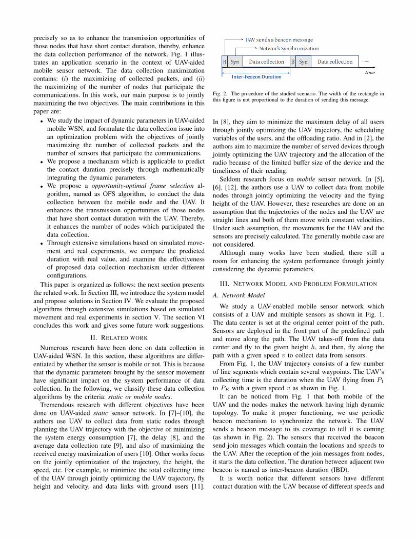
precisely so as to enhance the transmission opportunities ofthose nodes that have short contact duration, thereby, enhancethe data collection performance of the network. Fig. 1 illus-trates an application scenario in the context of UAV-aidedmobile sensor network. The data collection maximizationcontains: (i) the maximizing of collected packets, and (ii)the maximizing of the number of nodes that participate thecommunications. In this work, our main purpose is to jointlymaximizing the two objectives. The main contributions in thispaper are:• We study the impact of dynamic parameters in UAV-aided
mobile WSN, and formulate the data collection issue intoan optimization problem with the objectives of jointlymaximizing the number of collected packets and thenumber of sensors that participate the communications.
• We propose a mechanism which is applicable to predictthe contact duration precisely through mathematicallyintegrating the dynamic parameters.
• We propose a opportunity-optimal frame selection al-gorithm, named as OFS algorithm, to conduct the datacollection between the mobile node and the UAV. Itenhances the transmission opportunities of those nodesthat have short contact duration with the UAV. Thereby,it enhances the number of nodes which participated thedata collection.
• Through extensive simulations based on simulated move-ment and real experiments, we compare the predictedduration with real value, and examine the effectivenessof proposed data collection mechanism under differentconfigurations.
This paper is organized as follows: the next section presentsthe related work. In Section III, we introduce the system modeland propose solutions in Section IV. We evaluate the proposedalgorithms through extensive simulations based on simulatedmovement and real experiments in section V. The section VIconcludes this work and gives some future work suggestions.
II. RELATED WORK
Numerous research have been done on data collection inUAV-aided WSN. In this section, these algorithms are differ-entiated by whether the sensor is mobile or not. This is becausethat the dynamic parameters brought by the sensor movementhave significant impact on the system performance of datacollection. In the following, we classify these data collectionalgorithms by the criteria: static or mobile nodes.
Tremendous research with different objectives have beendone on UAV-aided static sensor network. In [7]–[10], theauthors use UAV to collect data from static nodes throughplanning the UAV trajectory with the objective of minimizingthe system energy consumption [7], the delay [8], and theaverage data collection rate [9], and also of maximizing thereceived energy maximization of users [10]. Other works focuson the jointly optimization of the trajectory, the height, thespeed, etc. For example, to minimize the total collecting timeof the UAV through jointly optimizing the UAV trajectory, flyheight and velocity, and data links with ground users [11].
Fig. 2. The procedure of the studied scenario. The width of the rectangle inthis figure is not proportional to the duration of sending this message.
In [8], they aim to minimize the maximum delay of all usersthrough jointly optimizing the UAV trajectory, the schedulingvariables of the users, and the offloading ratio. And in [2], theauthors aim to maximize the number of served devices throughjointly optimizing the UAV trajectory and the allocation of theradio because of the limited buffer size of the device and thetimeliness of their reading.
Seldom research focus on mobile sensor network. In [5],[6], [12], the authors use a UAV to collect data from mobilenodes through jointly optimizing the velocity and the flyingheight of the UAV. However, these researches are done on anassumption that the trajectories of the nodes and the UAV arestraight lines and both of them move with constant velocities.Under such assumption, the movements for the UAV and thesensors are precisely calculated. The generally mobile case arenot considered.
Although many works have been studied, there still aroom for enhancing the system performance through jointlyconsidering the dynamic parameters.
III. NETWORK MODEL AND PROBLEM FORMULATION
A. Network Model
We study a UAV-enabled mobile sensor network whichconsists of a UAV and multiple sensors as shown in Fig. 1.The data center is set at the original center point of the path.Sensors are deployed in the front part of the predefined pathand move along the path. The UAV takes-off from the datacenter and fly to the given height h, and then, fly along thepath with a given speed v to collect data from sensors.
From Fig. 1, the UAV trajectory consists of a few numberof line segments which contain several waypoints. The UAV’scollecting time is the duration when the UAV flying from P1
to PE with a given speed v as shown in Fig. 1.It can be noticed from Fig. 1 that both mobile of the
UAV and the nodes makes the network having high dynamictopology. To make it proper functioning, we use periodicbeacon mechanism to synchronize the network. The UAVsends a beacon message to its coverage to tell it is coming(as shown in Fig. 2). The sensors that received the beaconsend join messages which contain the locations and speeds tothe UAV. After the reception of the join messages from nodes,it starts the data collection. The duration between adjacent twobeacon is named as inter-beacon duration (IBD).
It is worth notice that different sensors have differentcontact duration with the UAV because of different speeds and
locations which means that they have different transmissionopportunities with the UAV. The key challenge is: how tobalance the transmission opportunities between them so asto enhance the data collection of the network.
B. Channel Model
To well implement the air-ground communication, both line-of-sight (LoS) and non-line-of-sight (NLoS) links [13] areconsidered in this paper. The LoS probability in tk is givenby [15],
PL,Sitk=
1
1 + a · exp[−b( 180π · arcsin(h
dtk (U,Si))− a)]
, (1)
where a and b are constants, and dtk(U, Si) is the distancebetween sensor Si and the UAV at tk. Then, the NLoSprobability is,
PNL,Sitk= 1− PL,Sitk ,
Then, the path loss is given by,
LSitk= lσ · (
4π · f · dtk(U, Si)c
)2 , (2)
where f is the carrier frequency, c is a constant, and lσ islLoS or lNLoS for excessive path losses of LoS and NLoSlinks respectively.
C. Problem Formulation
The data collection maximization issues contains two as-pects: (i) the maximization of the number of collected packets(Np), and (ii) the maximization of the number of nodes thatsuccessfully send a packet to the UAV (Nnode). Hence, inthis paper, we will jointly optimize the two objectives throughproposed mechanisms.
1) Optimization of Np: Let,
ζik =
{1 UAV communicate with Si at tk ,0 otherwise.
then,
Np =1
Ps
∑Si
∑tk
ζik · LSitk ·Dr · (tk − tk−1) , (3)
in which, Ps is the packet size, Dr is the data rate, and LSitkis given through (2). The optimization of Np is presented as,
P1 : maxSi,tk
{Np} , (4)
s.t.∑
(tk − tk−1) ≤ T , k ≥ 1 , (5)∑ζik ≤ N ,∀k , (6)
Constraints (5)-(6) imply that, a UAV only communicate withone node at the same time.
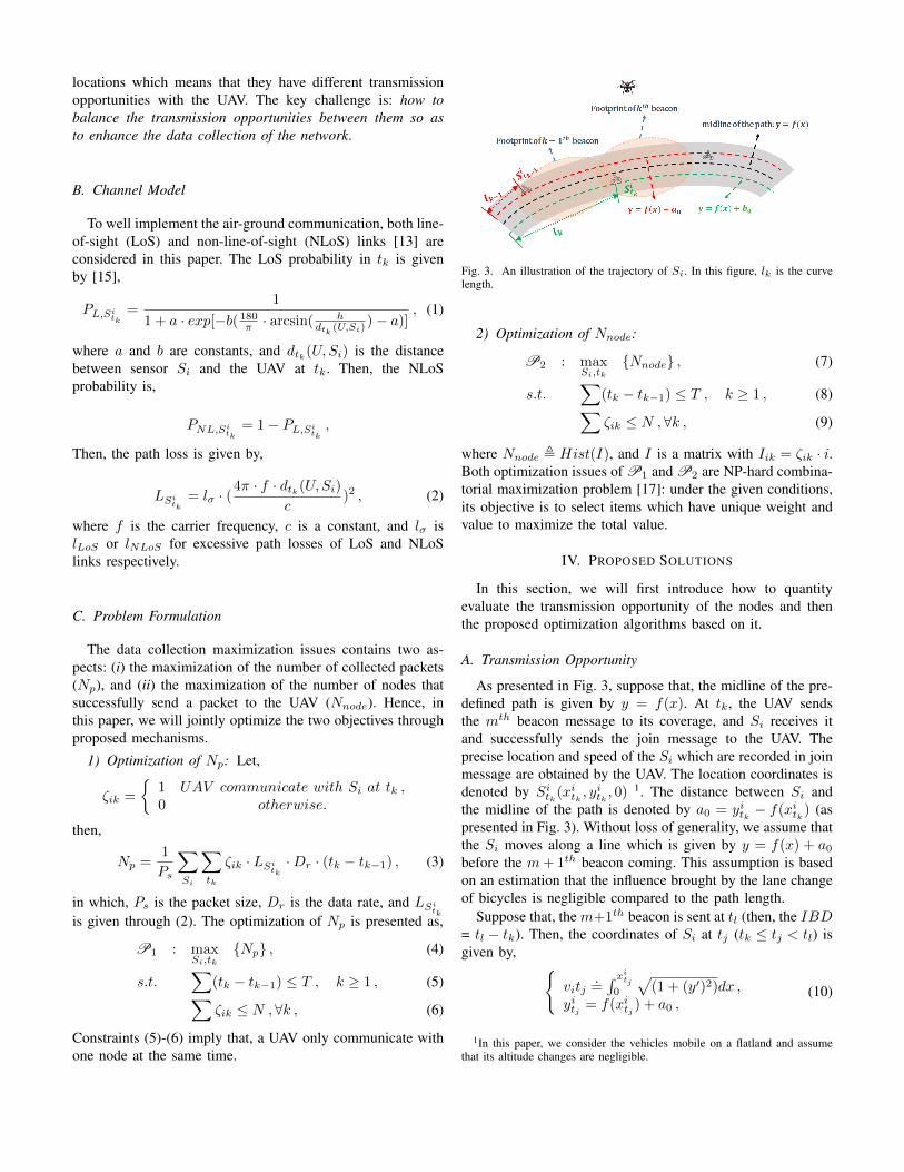
Fig. 3. An illustration of the trajectory of Si. In this figure, lk is the curvelength.
2) Optimization of Nnode:
P2 : maxSi,tk
{Nnode} , (7)
s.t.∑
(tk − tk−1) ≤ T , k ≥ 1 , (8)∑ζik ≤ N ,∀k , (9)
where Nnode , Hist(I), and I is a matrix with Iik = ζik · i.Both optimization issues of P1 and P2 are NP-hard combina-torial maximization problem [17]: under the given conditions,its objective is to select items which have unique weight andvalue to maximize the total value.
IV. PROPOSED SOLUTIONS
In this section, we will first introduce how to quantityevaluate the transmission opportunity of the nodes and thenthe proposed optimization algorithms based on it.
A. Transmission Opportunity
As presented in Fig. 3, suppose that, the midline of the pre-defined path is given by y = f(x). At tk, the UAV sendsthe mth beacon message to its coverage, and Si receives itand successfully sends the join message to the UAV. Theprecise location and speed of the Si which are recorded in joinmessage are obtained by the UAV. The location coordinates isdenoted by Sitk(x
itk, yitk , 0)
1. The distance between Si andthe midline of the path is denoted by a0 = yitk − f(x
itk) (as
presented in Fig. 3). Without loss of generality, we assume thatthe Si moves along a line which is given by y = f(x) + a0before the m+ 1th beacon coming. This assumption is basedon an estimation that the influence brought by the lane changeof bicycles is negligible compared to the path length.
Suppose that, the m+1th beacon is sent at tl (then, the IBD= tl − tk). Then, the coordinates of Si at tj (tk ≤ tj < tl) isgiven by, {
vitj.=∫ xitj0
√(1 + (y′)2)dx ,
yitj = f(xitj ) + a0 ,(10)
1In this paper, we consider the vehicles mobile on a flatland and assumethat its altitude changes are negligible.
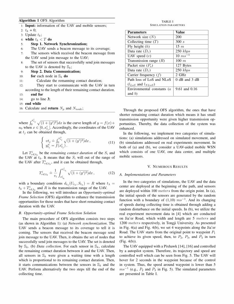
Algorithm 1 OFS Algorithm1: Input: information of the UAV and mobile sensors;2: tk = 0;3: Update tk;4: while tk < T do5: Step 1. Network Synchronization;6: The UAV sends a beacon message to its coverage;7: The sensors which received the beacon message from
the UAV send join message to the UAV;8: The set of sensors that successfully send join messages
to the UAV is denoted by Sk;9: Step 2. Data Communication;
10: for each node in Sk do11: Calculate the remanning contact duration;12: They start to communicate with the UAV in turn
according to the length of their remaining contact duration.13: end for14: go to line 3;15: end while16: Calculate and return Np and Nnode;
where∫ xitj0
√(1 + (y′)2)dx is the curve length of y = f(x)+
a0 when x ∈ [0, xitj ]. Accordingly, the coordinates of the UAVat tj can be obtained through,{
vtj.=∫ xutj0
√(1 + (y′)2)dx ,
yutj = f(xitj ) .(11)
Let T ird,tk be the remaining contact duration of the Si andthe UAV at tk. It means that the Si will out of the range ofthe UAV after T ird,tk , and it can be obtained through,
T ird,tk.=
1
vi
∫ xitλ
xitk
√(1 + (y′)2)dx , (12)
with a boundary conditions dtλ(Utλ , Stλ) = R where tλ =tk + T ird,tk and R is the transmission range of the UAV.
In the following, we will introduce an Opportunity-optimalFrame Selection (OFS) algorithm to enhance the transmissionopportunities for those nodes that have short remaining contactduration with the UAV.
B. Opportunity-optimal Frame Selection Solution
The main procedure of OFS algorithm consists two steps(as shown in Algorithm 1): (a) Network synchronization. TheUAV sends a beacon message to its coverage to tell it iscoming. The sensors that received the beacon message sendjoin message to the UAV. Then, it obtains the set of nodes thatsuccessfully send join messages to the UAV. The set is denotedby Sk. (b) Data collection. For each sensor in Sk, calculatethe remaining contact duration between it and the UAV. Then,all sensors in Sk were given a waiting time with a lengthwhich is proportional to its remaining contact duration. Then,it starts communications between the sensors in Sk and theUAV. Perform alternatively the two steps till the end of thecollecting time.
TABLE ISIMULATION PARAMETERS
Parameters ValueNetwork size (N ) 200Collecting time (T ) 300 sFly height (h) 15 mData rate (Dr) 250 kbpsUAV speed (v) 10 ms−1
Transmission range (R) 100 mPacket size (Ps) 127 BytesData rate (Dr) 250 kbpsCarrier frequency (f ) 2 GHzPath loss of LoS and NLoS(lLoS and lNLoS)
0 dB and 3 dB
Environmental constants (aand b)
9.61 and 0.16
Through the proposed OFS algorithm, the ones that haveshorter remaining contact duration which means it has smalltransmission opportunity were given higher transmission op-portunities. Thereby, the data collection of the system wasenhanced.
In the following, we implement two categories of simula-tions: (a) simulations addressed on simulated movement, and(b) simulations addressed on real experiments movement. Inboth of (a) and (b), we consider a UAV-aided mobile WSNwhich consists of one UAV, one data center, and multiplemobile sensors.
V. NUMEROUS RESULTS
A. Implementations and Parameters
In the two categories of simulations, the UAV and the datacenter are deployed at the beginning of the path, and sensorsare deployed within 100 meters from the origin point. In (a),the initial speeds of the sensors are generated by the randomfunction with a boundary of (1,10) ms−1. And its changingof speeds during collecting time is obtained through adding arandom disturbance on the initial speeds. In (b), we utilize thereal experiment movement data in [4] which are conductedon Jia’er Road, which width and length are 5 meters and1200 meters respectively, in Tongji University. As presentedin Fig. 4(a) and Fig. 4(b), we set 4 waypoints along the Jia’erRoad. The UAV starts from the original point to waypoint P1
to achieve its given speed, then, to P2, P3, and P4 in turn(Fig. 4(b)).
The UAV equipped with a Pixhawk [14], [16] and controlledby a autopilot system. Therefore, its trajectory and speed arecontrolled well which can be seen from Fig. 5. The UAV willhover for 2 seconds in the waypoint because of the controlin system. Thus, the speed around waypoint is lower than 5ms−1 (e.g., P2 and P3 in Fig. 5). The simulated parametersare presented in Table I.
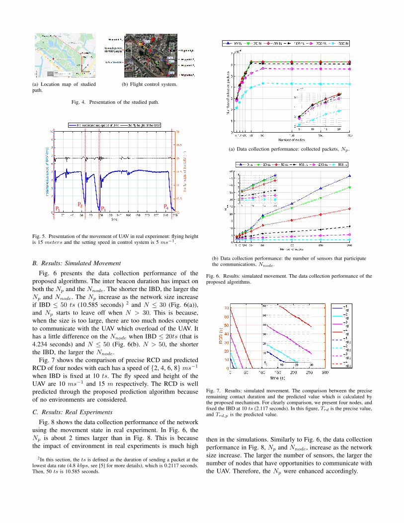
(a) Location map of studiedpath.
(b) Flight control system.
Fig. 4. Presentation of the studied path.
P1P2
P3P4
Fig. 5. Presentation of the movement of UAV in real experiment: flying heightis 15 meters and the setting speed in control system is 5 ms−1.
B. Results: Simulated Movement
Fig. 6 presents the data collection performance of theproposed algorithms. The inter beacon duration has impact onboth the Np and the Nnode. The shorter the IBD, the larger theNp and Nnode. The Np increase as the network size increaseif IBD ≤ 50 ts (10.585 seconds) 2 and N ≤ 30 (Fig. 6(a)),and Np starts to leave off when N > 30. This is because,when the size is too large, there are too much nodes competeto communicate with the UAV which overload of the UAV. Ithas a little difference on the Nnode when IBD ≤ 20ts (that is4.234 seconds) and N ≤ 50 (Fig. 6(b). N > 50, the shorterthe IBD, the larger the Nnode.
Fig. 7 shows the comparison of precise RCD and predictedRCD of four nodes with each has a speed of {2, 4, 6, 8}ms−1when IBD is fixed at 10 ts. The fly speed and height of theUAV are 10 ms−1 and 15 m respectively. The RCD is wellpredicted through the proposed prediction algorithm becauseof no environments are considered.
C. Results: Real Experiments
Fig. 8 shows the data collection performance of the networkusing the movement state in real experiment. In Fig. 6, theNp is about 2 times larger than in Fig. 8. This is becausethe impact of environment in real experiments is much high
2In this section, the ts is defined as the duration of sending a packet at thelowest data rate (4.8 kbps, see [5] for more details), which is 0.2117 seconds.Then, 50 ts is 10.585 seconds.
(a) Data collection performance: collected packets, Np.
(b) Data collection performance: the number of sensors that participatethe communications, Nnode.
Fig. 6. Results: simulated movement. The data collection performance of theproposed algorithms.
Fig. 7. Results: simulated movement. The comparison between the preciseremaining contact duration and the predicted value which is calculated bythe proposed mechanism. For clearly comparison, we present four nodes, andfixed the IBD at 10 ts (2.117 seconds). In this figure, Trd is the precise value,and Trd,p is the predicted value.
then in the simulations. Similarly to Fig. 6, the data collectionperformance in Fig. 8, Np and Nnode, increase as the networksize increase. The larger the number of sensors, the larger thenumber of nodes that have opportunities to communicate withthe UAV. Therefore, the Np were enhanced accordingly.
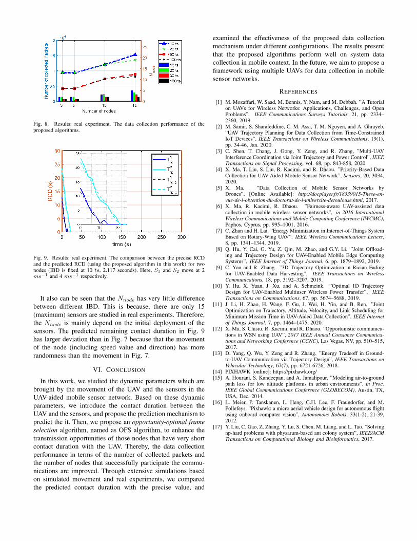
Fig. 8. Results: real experiment. The data collection performance of theproposed algorithms.
Fig. 9. Results: real experiment. The comparison between the precise RCDand the predicted RCD (using the proposed algorithm in this work) for twonodes (IBD is fixed at 10 ts, 2.117 seconds). Here, S1 and S2 move at 2ms−1 and 4 ms−1 respectively.
It also can be seen that the Nnode has very little differencebetween different IBD. This is because, there are only 15(maximum) sensors are studied in real experiments. Therefore,the Nnode is mainly depend on the initial deployment of thesensors. The predicted remaining contact duration in Fig. 9has larger deviation than in Fig. 7 because that the movementof the node (including speed value and direction) has morerandomness than the movement in Fig. 7.
VI. CONCLUSION
In this work, we studied the dynamic parameters which arebrought by the movement of the UAV and the sensors in theUAV-aided mobile sensor network. Based on these dynamicparameters, we introduce the contact duration between theUAV and the sensors, and propose the prediction mechanism topredict the it. Then, we propose an opportunity-optimal frameselection algorithm, named as OFS algorithm, to enhance thetransmission opportunities of those nodes that have very shortcontact duration with the UAV. Thereby, the data collectionperformance in terms of the number of collected packets andthe number of nodes that successfully participate the commu-nications are improved. Through extensive simulations basedon simulated movement and real experiments, we comparedthe predicted contact duration with the precise value, and
examined the effectiveness of the proposed data collectionmechanism under different configurations. The results presentthat the proposed algorithms perform well on system datacollection in mobile context. In the future, we aim to propose aframework using multiple UAVs for data collection in mobilesensor networks.
REFERENCES
[1] M. Mozaffari, W. Saad, M. Bennis, Y. Nam, and M. Debbah. ”A Tutorialon UAVs for Wireless Networks: Applications, Challenges, and OpenProblems”, IEEE Communications Surveys Tutorials, 21, pp. 2334–2360, 2019.
[2] M. Samir, S. Sharafeddine, C. M. Assi, T. M. Nguyen, and A. Ghrayeb.”UAV Trajectory Planning for Data Collection from Time-ConstrainedIoT Devices”, IEEE Transactions on Wireless Communications, 19(1),pp. 34-46, Jan. 2020.
[3] C. Shen, T. Chang, J. Gong, Y. Zeng, and R. Zhang, ”Multi-UAVInterference Coordination via Joint Trajectory and Power Control”, IEEETransactions on Signal Processing, vol. 68, pp. 843-858, 2020.
[4] X. Ma, T. Liu, S. Liu, R. Kacimi, and R. Dhaou. ”Priority-Based DataCollection for UAV-Aided Mobile Sensor Network”, Sensors, 20, 3034,2020.
[5] X. Ma. ”Data Collection of Mobile Sensor Networks byDrones”, [Online Available]: http://docplayer.fr/18339015-These-en-vue-de-l-obtention-du-doctorat-de-l-universite-detoulouse.html, 2017.
[6] X. Ma, R. Kacimi, R. Dhaou. ”Fairness-aware UAV-assisted datacollection in mobile wireless sensor networks”, in 2016 InternationalWireless Communications and Mobile Computing Conference (IWCMC),Paphos, Cyprus, pp. 995–1001, 2016.
[7] C. Zhan and H. Lai. ”Energy Minimization in Internet-of-Things SystemBased on Rotary-Wing UAV”, IEEE Wireless Communications Letters,8, pp. 1341–1344, 2019.
[8] Q. Hu, Y. Cai, G. Yu, Z. Qin, M. Zhao, and G.Y. Li. ”Joint Offload-ing and Trajectory Design for UAV-Enabled Mobile Edge ComputingSystems”, IEEE Internet of Things Journal, 6, pp. 1879–1892, 2019.
[9] C. You and R. Zhang. ”3D Trajectory Optimization in Rician Fadingfor UAV-Enabled Data Harvesting”, IEEE Transactions on WirelessCommunications, 18, pp. 3192–3207, 2019.
[10] Y. Hu, X. Yuan, J. Xu, and A. Schmeink. ”Optimal 1D TrajectoryDesign for UAV-Enabled Multiuser Wireless Power Transfer”, IEEETransactions on Communications, 67, pp. 5674–5688, 2019.
[11] J. Li, H. Zhao, H. Wang, F. Gu, J. Wei, H. Yin, and B. Ren. ”JointOptimization on Trajectory, Altitude, Velocity, and Link Scheduling forMinimum Mission Time in UAV-Aided Data Collection”, IEEE Internetof Things Journal, 7, pp. 1464–1475, 2020.
[12] X. Ma, S. Chisiu, R. Kacimi, and R. Dhaou. ”Opportunistic communica-tions in WSN using UAV”, 2017 IEEE Annual Consumer Communica-tions and Networking Conference (CCNC), Las Vegas, NV, pp. 510–515,2017.
[13] D. Yang, Q. Wu, Y. Zeng and R. Zhang, ”Energy Tradeoff in Ground-to-UAV Communication via Trajectory Design”, IEEE Transactions onVehicular Technology, 67(7), pp. 6721-6726, 2018.
[14] PIXHAWK [online]: https://pixhawk.org/[15] A. Hourani, S. Kandeepan, and A. Jamalipour, ”Modeling air-to-ground
path loss for low altitude platforms in urban environments”, in Proc.IEEE Global Communications Conference (GLOBECOM), Austin, TX,USA, Dec. 2014.
[16] L. Meier, P. Tanskanen, L. Heng, G.H. Lee, F. Fraundorfer, and M.Pollefeys. ”Pixhawk: a micro aerial vehicle design for autonomous flightusing onboard computer vision”, Autonomous Robots, 33(1-2), 21-39,2012.
[17] Y. Liu, C. Gao, Z. Zhang, Y. Lu, S. Chen, M. Liang, and L. Tao. ”Solvingnp-hard problems with physarum-based ant colony system”, IEEE/ACMTransactions on Computational Biology and Bioinformatics, 2017.