dwh long-term data management … long-term data management coordination workshop june 7 ... dwh...
TRANSCRIPT

DWH LONG-TERM DATA MANAGEMENT COORDINATION WORKSHOP JUNE 7 - 8, 2017
NOAA’S GULF OF MEXICO DISASTER RESPONSE CENTER
MOBILE, AL
WORKSHOP REPORT
COASTAL RESPONSE RESEARCH CENTER

DWH Long Term Data Management Coordination
Coastal Response Research Center 1
Acronyms
BOEM Bureau of Ocean Energy Management
CIMS Coastal Information Management System
CMAWG Council Monitoring and Assessment Workgroup
COC Containment of Concern
COP Common Operating Picture
CPRA Coastal Protection and Restoration Authority
CRRC Coastal Response Research Center
CWA Clean Water Act
DIVER Data Integration, Visualization, Exploration, and Reporting
DOI Digital Object Identifier
DRC Disaster Response Center
DWH Deepwater Horizon Oil Spill
DWHPT Deepwater Horizon Project Tracker
EDDM Environmental Disaster Data Management
EHS Environmental Health and Safety
ERMA Environmental Response Management Application
ESRI Environmental Systems Research Institute
FGDC Federal Geographic Data Committee
FIO Florida Institute of Oceanography
FTP File Transfer Protocol
FWRI Fish and Wildlife Research Institute
GCOOS Gulf of Mexico Coastal Ocean Observing System
GEOSS Global Earth Observing System of Systems
GIS Geographic Information System
GOM Gulf of Mexico
GOMA Gulf of Mexico Alliance
GoMRI Gulf of Mexico Research Initiative
GOOS Global Ocean Observing System
GRIIDC Gulf of Mexico Research Initiative Information and Data Cooperative
GRP Gulf Research Program
ICP Initial Comprehensive Plan
IEc Industrial Economics, Inc.
IOOS Integrated Ocean Observing System
IRB Institutional Review Board
ISO International Organization of Standardization
LTDM Long Term Data Management
MAM Monitoring and Adaptive Management
NARA National Archives and Records Administration
NAS National Academy of Sciences

DWH Long Term Data Management Coordination
Coastal Response Research Center 2
NCEI National Centers for Environmental Information
NFWF National Fish and Wildlife Foundation
NGO Non‐Governmental Organization
NOAA National Oceanic and Atmospheric Administration
NRDA Natural Resource Damage Assessment
OAIS Open Archival Information System
OPA 90 Oil Pollution Act of 1990
ORR Office of Response and Restoration
PI Principal Investigator
QA Quality Assurance
QC Quality Control
RESTORE Resources and Ecosystems Sustainability, Tourist Opportunities, and Revived Economies
SCAT Shoreline Cleanup Assessment Technique
SOP Standard Operating Procedures
SRM Standard Reference Material
TIG Trustee Implementation Group
USGS United States Geological Survey

DWH Long Term Data Management Coordination
Coastal Response Research Center 3
I. Acknowledgements
The content for this workshop was funded by the National Oceanic and Atmospheric Administration’s
(NOAA’s) Office of Response and Restoration and National Marine Fisheries Service (NMFS) Restoration
Center. NOAA’s National Centers for Environmental Information (NCEI) was also involved in the
development of the workshop. The following individuals served on the Organizing Committee:
Jonathan Blythe, BOEM
Julie Bosch, NOAA NCEI
Laura Bowie, GOMA
Libby Featherston, FIO
Jim Gibeaut, GoMRI
Jessica Henkel, RESTORE Council
Steve Jones, Geological Survey of AL
Barb Kirkpatrick, IOOS
Kirsten Larsen, NOAA NCEI
Matt Love, Ocean Conservancy
Laurie McGilvary, Dept. of Treasury
Amy Merten, NOAA ORR
Tamay Ozgokmen, University of Miami
Mike Peccini, NOAA NMFS
Jon Porthouse, NFWF
Jamey Redding, NOAA RC
Dave Reed, FL FWRI
Lauren Showalter, NAS
Greg Steyer, USGS
The workshop was facilitated by Dr. Nancy Kinner from the Coastal Response Research Center (CRRC;
www.crrc.unh.edu). CRRC has extensive experience with issues related to oil spills. The Center is known
for its independence and excellence in the areas of environmental engineering, marine science, and
ocean engineering as they relate to spills. CRRC has conducted numerous workshops bringing together
researchers, practitioners, and scientists of diverse backgrounds (including from government, academia,
industry, and non‐governmental organizations) to address issues in spill response, restoration and
recovery.
We wish to thank all the presenters for their participation in the workshop:
Julie Bosch, NOAA NCEI
Laura Bowie, GOMA
Craig Conzelmann, USGS
Jim Gibeaut, GRIIDC
Jessica Henkel, RESTORE Council
Matt Howard, GCOOS
Dan Hudgens, IEc
Michele Jacobi, NOAA ORR
Larry Langebrake, Connectsix
Matt Love, Ocean Conservancy
Laurie McGilvray, Dept. of Treasury
Marti Goss McGuire, NOAA RC
Amy Merten, NOAA ORR
William Nichols, GRIIDC
Rost Parsons, NOAA NCEI
Mike Peccini, NOAA RC
Jon Porthouse, NFWF
Steve Ramsey, Social & Scientific
Systems
Jamey Redding, NOAA RC
Ben Shorr, NOAA ORR
Lauren Showalter, NAS
Greg Steyer, USGS

DWH Long Term Data Management Coordination
Coastal Response Research Center 4
We would like to thank Mark Miller, Dan Hudgens, Rost Parsons, Steve Ramsey, Larry Langebrake and
Ann Jones for being breakout group leaders as well as Jay Coady, Nadia Martin, JB Huett, Megan
Verfaille, Kathy Mandsager and Melissa Gloekler for their note taking during the workshop.
We thank the ORR Gulf of Mexico (GOM) Disaster Response Center (DRC) for hosting the workshop.
DWH Long Term Data Management Coordination
Coastal Response Research Center 5
II. Introduction
On June 7 and 8, 2017, the Coastal Response Research Center (CRRC)1, NOAA Office of Response and
Restoration (ORR) and NOAA National Marine Fisheries Service (NMFS) Restoration Center (RC), co‐
sponsored the Deepwater Horizon Oil Spill (DWH) Long Term Data Management (LTDM) workshop at
the ORR Gulf of Mexico (GOM) Disaster Response Center (DRC) in Mobile, AL.
There has been a focus on restoration planning, implementation and monitoring of the on‐going DWH‐
related research in the wake of the DWH Natural Resource Damage Assessment (NRDA) settlement.
This means that data management, accessibility, and distribution must be coordinated among various
federal, state, local, non‐governmental organizations (NGOs), academic, and private sector partners. The
scope of DWH far exceeded any other spill in the U.S. with an immense amount of data (e.g., 100,000
environmental samples, 15 million publically available records) gathered during the response and
damage assessment phases of the incident as well as data that continues to be produced from research
and restoration efforts. The challenge with the influx in data is checking the quality, documenting data
collection, storing data, integrating it into useful products, managing it and archiving it for long term
use. In addition, data must be available to the public in an easily queried and accessible format.
Answering questions regarding the success of the restoration efforts will be based on data generated for
years to come. The data sets must be readily comparable, representative and complete; be collected
using cross‐cutting field protocols; be as interoperable as possible; meet standards for quality
assurance/quality control (QA/QC); and be unhindered by conflicting or ambiguous terminology.
During the data management process for the NOAA Natural Resource Damage Assessment (NRDA) for
the DWH disaster, NOAA developed a data management warehouse and visualization system that will
be used as a long term repository for accessing/archiving NRDA injury assessment data. This serves as a
1 A list of acronyms is provided on Page 1 of this report.

DWH Long Term Data Management Coordination
Coastal Response Research Center 6
foundation for the restoration project planning and monitoring data for the next 15 or more years. The
main impetus for this workshop was to facilitate public access to the DWH data collected and managed
by all entities by developing linkages to or data exchanges among applicable GOM data management
systems.
There were 66 workshop participants (Appendix A) representing a variety of organizations who met at
NOAA’s GOM Disaster Response Center (DRC) in order to determine the characteristics of a successful
common operating picture for DWH data, to understand the systems that are currently in place to
manage DWH data, and make the DWH data interoperable between data generators, users and
managers. The external partners for these efforts include, but are not limited to the: RESTORE Council,
Gulf of Mexico Research Initiative (GoMRI), Gulf of Mexico Research Initiative Information and Data
Cooperative (GRIIDC), the National Academy of Sciences (NAS) Gulf Research Program, Gulf of Mexico
Alliance (GOMA), and National Fish and Wildlife Foundation (NFWF).
The workshop objectives were to:
Foster collaboration among the GOM partners with respect to data management and
integration for restoration planning, implementation and monitoring;
Identify standards, protocols and guidance for LTDM being used by these partners for DWH
NRDA, restoration, and public health efforts;
Obtain feedback and identify next steps for the work completed by the Environmental Disasters
Data Management (EDDM) Working Groups; and
Work towards best practices on public distribution and access of this data.
The workshop consisted of plenary presentations and breakout sessions. The workshop agenda
(Appendix B) was developed by the organizing committee. The workshop presentations topics included:
results of a pre‐workshop survey, an overview of data generation, the uses of DWH long term data, an

DWH Long Term Data Management Coordination
Coastal Response Research Center 7
overview of LTDM, an overview of existing LTDM systems, an overview of data management standards/
protocols, results from the EDDM working groups, flow diagrams of existing data management systems,
and a vision on managing big data.
The breakout sessions included discussions of: issues/concerns for data stakeholders (e.g., data users,
generators, managers), interoperability, ease of discovery/searchability, data access, data synthesis,
data usability, and metadata/data documentation.
DWH Long Term Data Management Coordination
Coastal Response Research Center 8
III. Plenary Presentations
The workshop presentations topics included: results of a pre‐workshop survey, an overview of data
generation, the uses of DWH long term data, the overview of LTDM, the overview of existing LTDM
systems, existing data management standards/ protocols, the products of EDDM working groups, flow
diagrams of existing data management systems, and a vision on managing big data. Most of the
speakers provided a summary of their presentations (below) and presentation slides are located in
Appendix C.
Survey Results
Jessica Henkel (RESTORE Council) presented the results of a pre‐workshop survey (Appendix D) which
collected information on the perspective of the participants regarding data management and their goals
and objectives of LTDM of DWH data. Of the 47 survey responses received, 55% of participants
described themselves as data managers or administrators, 17% as data users, 15% as program managers
or funders, 10% as data generators, and 2.1% as decision makers. The majority of respondents wanted
GOM research/monitoring data over the next 15 years follow a common set of standards, be accessible
and interoperable for all users, and be stored in a long term data repository. However, they were not
optimistic about that being achieved. Many saw developing and adhering to a common set of data
standards across GOM data generators as one of the biggest challenges for GOM LTDM.
Overview of Data Generation of the DWH Oil Spill
Michele Jacobi (NOAA ORR) described the DWH Oil Spill from the perspective of a data generator. The
DWH incident falls far outside of the “normal” spill in terms of data generation with 20,000 trips to the
field to collect data, 100,000 environmental samples collected and 15 million records publically
available.

DWH Long Term Data Management Coordination
Coastal Response Research Center 9
The DWH spill affected five states (TX, LA, AL, FL, MS) which became the focus areas for data collection.
The DWH data aided the ecosystem overview and helped determine the actual impact of the oil at each
location. There was a heavy reliance on technology to capture the impacts of the oil spill. Data sets came
from the principal investigators (PIs), NGOs, state and federal agencies, academic institutions and
independent parties. Much of the data was stored in the Environmental Response Management
Application platform (ERMA®) which served as the common operational picture during the response.
ERMA showed the results of NOAA’s oil trajectory modeling and where clean up already took place;
locations for Shoreline Cleanup Assessment Technique (SCAT) and scientists in the field; and aided in
public transparency. Additionally, it supported the NRDA process and includes monitoring data
generated during the restoration.
Response data includes public safety, response activities, SCAT, closures and advisories to inform
recreation effects; provides evidence of exposure; and documents the extent of the spill. NRDA activities
during the response included: (1) setting a baseline, collecting ephemeral data to document conditions
before and after the spill, estimating fish kills, (2) fingerprinting of oil on shorelines, and in the water
column, and (3) studying changes to recreation use and socio‐economic impacts. Understanding and
capturing these pieces of information aids in planning restoration activities. On‐going monitoring is
required to determine how the various restoration programs are progressing and meeting their
objectives; and whether they are necessary vs. natural recovery.
The large influx of data throughout and after the spill helped determine best practices for data
collection and management; data documentation became extremely important and scientists needed to
work with data managers to make the data useful. Data remains accessible to future users in databases
and may be accessed by the public through data repositories. There were many data generation lessons
learned throughout the DWH spill, including having: a strong sampling design, multi‐disciplinary
questions, coordination across lab studies and field studies, clearly defined objectives of data collection
DWH Long Term Data Management Coordination
Coastal Response Research Center 10
relative to action or decision making, a budget to perform data collection and management, and
adherence to existing federal requirements and standards.
Uses of DWH Long Term Data
Matt Love (Ocean Conservancy) presented many uses for DWH data as well as overview of data
products and end users. His presentation stressed the large scale marine ecosystem restoration process
and the numerous data sets and types to be collected during GOM restoration. The only other scientific
effort that compares in terms of data collection is the Census of Marine Life, a Decade of Discovery. The
Census of Marine Life is a good representation of what can be done with DWH data, in the ways it
facilitates free and open access to data, integrates existing data with new surveys to establish a
complete picture, and compiles a data assimilation framework.
The goal of the DWH LTDM is to create an interoperable infrastructure that allows for data sharing and
accessibility. Prior to DWH, the discussion of data management often stopped at the generators.
Moving forward, generators need to collaborate with end users to expand planning through data use
and synthesis. Data generators should envision a data system that enables an end goal that allows for
development of data products to aid decision making and long term resource management.
A network of data users will rely on data and synthesized data products to make informed decisions
(e.g., business or NGO research, response, restoration, management) based on their shared stake in the
ultimate outcome of restoration. Spill responders will need access to real‐time data and a common
operation picture to help support functional decision making to control environmental damages. Using
the generated data, the research community has many opportunities to collaborate on assessing the
status and trends of GOM ecosystems to guide restoration and long term management strategies. The
full‐scale restoration process requires a unique set of data to inform what actions must be taken to
repair the full suite of priority damages from the spill and long term degradation.

DWH Long Term Data Management Coordination
Coastal Response Research Center 11
GOM restoration will be a long term process that will require enhanced analytical data applications such
as ecosystem modeling. Models are data hungry and require vast amounts of information. Models can
assist decision makers in determining if proposed restoration activities will help an area or ecosystem
component of concern. The can serve as the foundation for assessing the value of implemented if
restoration actions and to help determine if changes to implemented actions should be made.
There is a vast array of monitoring programs to inform GOM management and monitoring targeted at
DWH restoration, all initiated by different organizations and funders. The data from both sources will
serve the needs of the broader management community, and provide added benefits for enabling
collaborative science to address priority questions pertaining to recovery and management of the GOM.
The long term vision for these diverse programs (i.e., 15+ years) is moving towards a collaborative
restoration effort. A successful restoration outcome hinges on reasonable decisions based on open,
accessible data that can be synthesized by a variety of users. Restoration programs and data
generators, as defined in this workshop, must envision the potential uses for the data beyond their
immediate application through insuring data accessibility for future applications and broader scientific
inquiries.
Overview of Long Term Data Management (LTDM)
Lauren Showalter (NAS) gave an overview of steps taken to ensure the legacy of science that came from
DWH. The NAS focuses on making data accessible to researchers studying future disasters, and ensuring
the research products are well documented and in stable formats. In order to frame the discussion of
LTDM as it relates to the DWH disaster, the NAS identified a number of key topics for initial discussion:
metadata, standards, federal mandates, data sharing, and interoperability. A basic overview of these
terms was presented to help frame discussions over the course of the workshop.

DWH Long Term Data Management Coordination
Coastal Response Research Center 12
DWH data types vary from human health, restoration and monitoring, oil systems safety, environmental,
social science to real time data. The data is from a variety of sources and will be managed by private,
state, and federal archives. Due to the interdisciplinary research products coming from the generated
data, it is important to make the data interoperable between archives and repositories. The
presentations noted specific standards and recommendations that have been used by ongoing GOM
data efforts to ensure ease of collaboration as programs develop. The terms data archive and data
repository were clarified vis‐a‐vis federal requirements; although these terms are sometimes used
interchangeably they have distinct meanings within the federal data structure.
Data documentation (i.e., metadata) must be done well and standardized in order to make data usable
and accessible in future. For example, the International Organization of Standardization (ISO) 19115
standards should be adopted by future data generators. The challenge is getting the research
community to actually follow standards and share data.
Data citation supports proper attribution and credit of the data generator which facilities the future use
and collaboration between researchers and their data. It enables reproducibility of findings and fosters
faster and more efficient research progress. Ensuring data is properly attributed and documented is
essential for ease of redistribution and reuse. The creation of standard, machine readable metadata, the
use of digital object identifiers (DOI), and adherence to data collection standards are important aspects
of the data management process. As more data is collected, the use of tools and distributed data
frameworks can improve interoperability and facilitate data synthesis. The use of data visualization can
also help display the value of complex datasets and increase their use for other purposes than they were
originally collected.
Accessibility of data is important to determining baselines of data, and determining what conditions
were known prior to a disaster. Availability of data also provides opportunity for users to retrieve data
DWH Long Term Data Management Coordination
Coastal Response Research Center 13
for exploration, analysis and decision making. Additionally, data interoperability is needed to compare
metrics and baselines to better understand monitoring data and allow human readable and machine‐to‐
machine compatibility. Consistency with metadata helps data sharing, which is essential when using real
time data. Ideally, there would be an existing framework allowing data users to search by “text” or
“keywords”. These frameworks must portray data in an aesthetic and easy‐to‐use manner. Data
visualization aids and good data management practices allow data to be easily reused and synthesized
to develop useful products.
IV. Overview of Existing LTDM Systems: Speed Presentations
Data Integration, Visualization, Exploration, and Reporting (DIVER) & Environmental Response Management Application (ERMA)
Ben Shorr (NOAA ORR) presented two data synthesis/management systems: DIVER and ERMA®. These
two programs require standardized data and contain thorough metadata to facilitate data sharing and
exchange. DIVER is a data warehouse, query tool, and collaboration application. DIVER integrates
standardized datasets so users can query across data holdings and download information and results. It
is a warehouse that can accommodate various formats of raw data and integrates it into a common
format that many users can query and download. DIVER is also a one‐stop repository for those working
on a spill or site to submit their data and quickly transform it into a usable format for tracking, reporting
and analysis from response to restoration. It was designed for incorporation of data coming in through
multiple pathways including, quick provision field data and laboratory results that have been though the
QA/QC process. DIVER has key capabilities to file and load collections from field forms, Contaminates of
Concern (COCs), photos and notes. It allows multiple users to examine raw data that was collected in the
field, and data managers to transcribe or input it into the new DIVER platform for application. The
program transcribes, processes, and parses the data appropriately based on the DIVER common data

DWH Long Term Data Management Coordination
Coastal Response Research Center 14
model; after transcription the data is available for query, export and loading into ERMA for visualization
purposes.
ERMA is an online geographic information system (GIS) and visualization tool that allows users to view
response, assessment, and restoration mapping layers in context with other environmental information.
ERMA is available for the Pacific Northwest, Pacific Southwest, Great Lakes, the Atlantic Coast, and the
GOM. Early in the DWH response, a GOM ERMA was created. It has standard layers specialized for each
region/state and is accessible to the public. Some data is privileged and requires log‐in for the use of
additional tools. It functions as a common operating picture (COP) that was used for the NRDA. It can
also be used to plan and monitor restoration efforts. It is a system that allows others to load and
exchange spatial data from state, federal, NGO, tribal and academic organizations.
DIVER Portal Restoration Tracking
Mike Peccini (RC) presented a brief overview of how the RC is using DIVER to manage DWH restoration
project tracking and monitoring data. Restoration project tracking within DIVER was developed to meet
data management and reporting requirements outlined the DWH Consent Decree, Trustee Council
Standard Operating Procedures (SOPs), and the DWH Monitoring and Adaptive Management Manual.
The DIVER portal provides project managers from all state and federal trustee agencies with role‐based
access to common workspaces and data entry tools allowing for distributed management of project‐
level data. Project tracking data includes information describing: project status, location(s), budget,
implementation activities, accomplishments, and monitoring results. Project data is being used to serve
Trustee Council reporting needs and to inform the public via maps, dashboards, project information
pages, and query tools.
Project monitoring field data will be managed within the DIVER data warehouse and made accessible
through integrated DIVER search tools. To the extent possible, monitoring data will be standardized

DWH Long Term Data Management Coordination
Coastal Response Research Center 15
within resource types and integrated into DIVER data models to maximize interoperability across Gulf
monitoring and assessment data.
NOAA National Centers for Environmental Information (NCEI)
Rost Parsons (NCEI) provided an introduction to NCEI which is the data management and archive entity
for oceanographic, geophysical, and climatological information within the U.S. NCEI is a science‐based
organization that produces environmental information to enable individuals, businesses, and
governments to make informed decisions. It provides the foundation for more tailored decision‐support
services to be developed and delivered by the public and private sector.
The Open Archival Information System (OAIS) is a reference model which mandates an important set of
responsibilities and functions for the archive to perform. It is not an implementation architecture, but a
system that can ingest data and allow access to it. NCEI may expand the application of OAIS to be a
more integrated and robust ingest service. This would enable NCEI to add additional stewardship
services (e.g., automated QA, granule metadata generation). Currently, metadata standards being
implemented are ISO 19115. Having standardized metadata ensures easier archiving and aids in data
interoperability. The data archive must follow the National Archive and Records Administration (NARA)
requirements, uses Library of Congress guidance for data formats, and applies common or managed
vocabularies as a NCEI standard practice. As standards evolve over time, and the structure for metadata
and its content should not be static but be adaptable as well. NOAA Administrative Order 212‐15
(Management of Environmental Data and Information) cites overarching mandates from the Federal
Records Management Act to the National Archives and Records Administration (NARA) and Agency
Directives.
NCEI outlined Tiers of Stewardship to help organize data management. The Tier 1 Long Term
Preservation and Basic Access of Data; this tier is concerned with preservation of the original data with

DWH Long Term Data Management Coordination
Coastal Response Research Center 16
robust metadata for data discovery/access, and safeguarding the data over its entire life‐cycle. Tier 2, is
Enhanced Access and Basic Quality Assurance, entailing the creation of complete metadata to enable
automated quality assurance and statistic collection, and improved overall data access through
specialized software services for users and applications. Tier 3 is Scientific Improvements to allow data
to be reprocessed in new and improved versions to distribute to users. Additionally, it improves the data
quality or accuracy with scientific quality assessments, controls, warning flags and corrections. Tier 4,
derived products, builds upon archived data to create new products that are more broadly useful and
analyzes/combines products and data to create new or blended scientific data products. Tier 5 is
Authoritative Records that focus on combining multiple time series into a single, inter‐calibrated
product and establish authoritative quality and uncertainties, and ensure full documented and
reproducible products. Tier 6, National Services and International Leadership, would lead coordination
or implementation of scientific stewardship activities for a community across disciplines and establish
highly specialized levels of data services and product assessments.
GRIIDC
Jim Gibeaut (GRIIDC) spoke on behalf of the GoMRI and GRIIDC; their objective is ensuring data access
and an information legacy that promotes continual scientific discovery and public awareness for the
GOM. GRIIDC serves the entire life cycle of data, beginning with planning for collection, tracking the
process, providing proper documentation, archiving the information, and disseminating of the data. All
data that is collected under GoMRI must be publically available and usable within one year or at the
time of publication (whichever comes first). It is a repository for citable data packages for future users to
access and validate results of their scientific research. The datasets are interdisciplinary (e.g., field and
laboratory data), and the researchers must meet data management plans previously set GoMRI/GRIIDC.
The data is tracked in order to ensure it meets data sharing standards, such as proper data

DWH Long Term Data Management Coordination
Coastal Response Research Center 17
documentation. GRIIDC will support GoMRI data until at least 2030 and will hopefully expand to services
beyond GoMRI‐funded research to integrate with other repositories.
GOMA Portal
William Nichols (GRIIDC/Harte Research Institute) presented the GOMA Portal which is a data catalogue
and repository that provides data discovery and access to GOM geospatial datasets. Users have the
ability to search for data using a metadata catalog, topic, keyword and spatial search; view information;
and download it via File Transfer Protocol (FTP). Most of the records reside on the server which allows
for direct downloads. The GOMA Portal houses upwards of 800 data sets that do not have a stable
repository. The organization wrote metadata for these 800 sets; the data came from a variety of sources
with different documentation methods. The metadata follows Federal Geographic Data Committee
(FGDC) standards and supports ISO 19115‐2 and ISO 19119 (web services) as well as the Dublin Core for
non‐geospatial data types. The portal is based on an open‐sourced Environmental Systems Research
Institute (ESRI) geoportal platform, which allows interoperability between platforms.
DWH Project Tracker (DWHPT)
Laura Bowie (GOMA) presented the DWH Project Tracker (DWHPT) which is a system designed to track
projects that are funded by programs resulting from the DWH – voluntary and negotiated settlement
programs. The concept for a project tracker was developed by the GOM states as a way to try to
understand what is being funded through the myriad of programs. The DWHPT only contains awarded
projects (not proposed or unfunded) and it is currently 99% complete with 597 projects. The DHWPT
categorizes projects in four primary types: environmental, human and social/planning, recreational use,
and science/research. Each project “dot” on the map links to a “popup” box that provides basic
information about the project and a link to the funding program’s database for more information. The
system is queriable using a wide variety of metadata including geographic location. It also has some

DWH Long Term Data Management Coordination
Coastal Response Research Center 18
standard “canned” reports. Primary users of the system tend to be the public, media, and restoration
planning programs.
Louisiana Coastal Information Management System (CIMS)
Craig Conzelmann (U.S. Geological Survey (USGS)) spoke on behalf of the LA Coastal Information
Management System (CIMS) Portal. Topics covered were: (1) observational data inputs, quality control,
and downloads, (2) the CIMS spatial framework, and (3) the Coastal Protection and Restoration
Authority’s (CPRA) use of a digital library.
CIMS is a suite of data driven applications and tools used to manage, visualize, share and analyze coastal
data. A variety of data types (e.g., tabular, spatial, unstructured) can be used. Standardization is done
though data documentation; metadata is currently required to follow FGDC formatting. Moving
forward, it will be ISO standards. CIMS has a clean interface, mapping, data and library to ensure public
usability. The library identifies documents by various type, project, name and location. There are options
to add layers and control visibility which enhances the shareability of data. Contractors have the ability
to enter data from the field on a Smartphone. The CIMS Portal only houses Louisiana data.
Gulf of Mexico Coastal Ocean Observing System (GCOOS)
Matt Howard (GCOOS) explained that the Gulf of Mexico Coastal Ocean Observing System (GCOOS) is
one of 11 Regional Associations organized under the U.S. Integrated Ocean Observing System (IOOS)
which is the U.S. contribution to the Global Ocean Observing System (GOOS), the oceanic component of
the Global Earth Observing System of Systems (GEOSS). GCOOS’ goal is to deliver high‐quality data from
sensors to the desktop through networked systems without loss of information. GCOOS adheres to
community standards and best practices in data stewardship and specializes in physical oceanographic,
marine meteorological and biogeochemical data; and numerical model outputs. It has recently begun to
work with marine biological data (e.g., plankton, fisheries). GCOOS works with near real‐time data (i.e.,
1600+ sensors), and delayed‐mode data, and has extensive historical data collections including

DWH Long Term Data Management Coordination
Coastal Response Research Center 19
climatology and quasi‐static datasets (e.g., bathymetry, coastline). GCOOS serves data through standard
interfaces in preferred formats and produces data‐based products. GCOOS aggregates products from
outside data collectors and combines data into a usable format. GCOOS a full‐time education and
outreach coordinator, holds stakeholder workshops, and hosts and serves data and products for Citizen
Scientist groups. GCOOS is funded thorough 2021 and has 3+ full‐time equivalents devoted to data
management issues.
V. Data Management Standards and Protocols: Speed Presentations
Data Management Frameworks
RESTORE Council
Jessica Henkel (RESTORE) discussed the structure of the Gulf Coast Ecosystem Restoration Council
(RESTORE Council), and the many funding recipients that will be generating data from RESTORE Council‐
funded activities. Her presentation discussed current data requirements for grant recipients. All data is
to be digital and machine‐readable, have the ability to be made publically available, and must comply
with all federal laws and policies. In 2017, the Council staff will be exploring metadata development
tools for funding recipients, and working with the Council Monitoring and Assessment Workgroup
(CMAWG) to develop data management framework options for Council consideration.
NRDA Restoration Project Monitoring
Jamey Redding’s (NOAA RC) presentation on NRDA restoration monitoring included a description of
what was outlined in the Trustee Council SOP, what may be further developed within the Monitoring
and Adaptive Management (MAM) Manual with the Cross‐TIG Monitoring and Adaptive Management
Workgroup (Cross‐TIG MAM), and what next steps will be taken.
The DWH NRDA Restoration effort focuses on environmental data specific to monitoring and adaptive
management. This data may be generated during any phase/component of restoration implementation,

DWH Long Term Data Management Coordination
Coastal Response Research Center 20
as part of any project‐specific monitoring, or non‐project specific data collection. Within the SOP, the
general standards for monitoring, data format, and data management are outlined. The Cross‐TIG MAM
Workgroup will develop these topics further and include this information in the MAM Manual.
Standardization of monitoring data with respect to parameters and metrics, precision, units,
performance criteria, and collection protocols, will increase consistency, allow further analysis across
TIGs and restoration types, and enhance compatibility with existing datasets.
The MAM Manual will include protocols for data review and clearance, storage and accessibility,
sharing, and analysis and synthesis. Standardizing the aforementioned protocols will assist with QA/QC,
validation of data, interoperability, and public accessibility. Trustees will follow standards and protocols
set in the Federal Open Data Policy. Data can be accessed through warehouses such as DIVER and
though the Trustee Council website. The data management section, outlined in the MAM Manual
Version 1.0, outlines specific standards and management procedures to build within DIVER the
capability and functionality for MAM data.
Direct Component & Centers of Excellence‐ U.S. Department of the Treasury
Laurie McGilvray (Treasury) presented the RESTORE Act and the data management framework, on
behalf of the U.S. Treasury and the Office of Gulf Coast Restoration. The Clean Water Act (CWA) penalty
funds for the DWH went to the Gulf Coast Restoration Trust Fund. It is the Treasury’s responsibility
allocate funds for the Direct Component portion of these funds and for the Centers of Excellence
Research Grants. The Direct Component section allocates 35% of the Gulf Restoration Trust Fund among
five states (i.e., AL, FL, LA, MS, TX) to help with ecosystem restoration, economic development and
tourism promotion.
Additionally, the Treasury administers 2.5% plus interest earned from the Trust Fund’s investments for
research on the Gulf Coast Region. The funds are allocated to the same five states. Within these states,

DWH Long Term Data Management Coordination
Coastal Response Research Center 21
Centers of Excellence are awarded funding for research grants. Research topics include, but are not
limited to: coastal sustainability, restoration and protection, offshore energy development, coastal
fisheries and wildlife monitoring and research, sustainable and resilient growth, and economic and
commercial development in the Gulf Coast Region.
The RESTORE Act grant requires performance reporting which includes: summarizing any significant
findings or events, including compiled, collected or created data; description of activities to disseminate
or publicize results of the activity; and designation of the project or program responsible for the
generation of that data. In many instances, data being collected use a common repository and are being
put into an existing data framework.
National Fish and Wildlife Foundation (NFWF)
Jon Porthouse (NFWF) provided an overview of NFWF which is a non‐federal entity focusing on
ecosystem restoration and monitoring. There is no regulatory framework in place and the organization
works with multiple states. NFWF works with a variety of stakeholders (i.e., federal, state, county,
municipal, NGO, academia) to generate and manage data. The organization funds data generation, but
does not house it; in some instances, the organization collects metadata as it sees fit. NFWF has no
overarching data management requirements for its grantees.
NAS Gulf Research Program (GRP)
Lauren Showalter explained that GRP will be requiring all grantees to make data or information products
that result from its funded research publically available within one year of the end of the grant. The GRP
will provide grantees with a list of acceptable data repositories that have been identified with assistance
from the GRP Advisory Board. The GRP will also create a catalog of data and information resources so
interested parties can access all of these products.

DWH Long Term Data Management Coordination
Coastal Response Research Center 22
The GRP has a public data policy and requires that all submitted proposals include a data management
plan that is reviewed by the Program Officer prior to panel review of the proposal. Once a project is
funded, the GRP works with researchers to ensure they are familiar with GRP data procedures and policy
and continues to assist them as data is created so they develop sufficient metadata and identify the
most appropriate repository.
VI. Standards, Parameters, and Challenges
Greg Steyer (USGS), presented on standards, guidance and challenges that affect the monitoring
community. The community of monitoring and data acquisition is complex and encompasses state and
federal agencies, the RESTORE Council, the academic community and others. A tremendous amount of
data is being collected and the various DWH programs are working together to determine common
monitoring standards and protocols. Standardizing the protocols would simplify the aggregation and
synthesis of data following data collection.
The approach to standardizing data management is a 3‐year, Phase 1 program which lays the foundation
for a structure and implementation strategy related to monitoring. This strategy would enable the
Restore Council to achieve the goals, objectives and commitments in its Initial Comprehensive Plan (ICP).
The approach is to use coordination and collaboration to build upon the numerous existing monitoring
activities and programs in the GOM. It is necessary to engage expertise within groups such as GCOOS,
the state and federal resource agencies, state Centers of Excellence, academia, NAS, NGOs, industry and
other interested stakeholders to move towards a coordinated GOM‐wide monitoring and assessment
program. Successful data acquisition would include: a catalog of existing data, an understanding of how
existing data can be fully used, the quality of data being generated, and by following a minimum set of
standards to ensure proper metadata and QA/QC.

DWH Long Term Data Management Coordination
Coastal Response Research Center 23
DWH data should be aggregated, stored, and the quality assured such that it can be disseminated. Using
existing capabilities (e.g., web portals, catalogues, archives) is advantageous to avoid creating new
systems. Standardizing data description, formats and services would promote interoperability between
existing systems.
Challenges with data management include bringing together existing data monitoring and management
agencies from inception to develop an integrated process; and communicating and coordinating across
both DWH and non‐DWH programs. When developing data management systems, user needs should be
considered, and data generators should clearly articulate measurable objectives from project to
programmatic scales. The generators should delineate common sets of questions that need to be
addressed so researchers are not asking the same questions. Other major challenges are adopting
common data standards, following minimum monitoring standards and data requirements, and
governing across programs.
Environmental Disasters Data Management Workshop (EDDM) Working Groups
The Environmental Disasters Data Management (EDDM) Working Groups are an outcome of a CRRC
workshop held in September 2014, the objectives were to promote the use of the protocols and
practices during data collection, as well as recommend data management limitations to be later
discussed in workshops. The overall goal of the working groups is to provide information and data
services that improve the quality and speed of decision‐making in response to environmental disasters.
The EDDM Working Groups were coordinated by CRRC, NOAA’s National Coastal Data Development
Center and NOAA ORR. EDDM Working Groups focused on Field Protocols, Common Data Models, and
“Gold” Standards. Additional information regarding EDDM can be found at https://crrc.unh.edu/EDDM.

DWH Long Term Data Management Coordination
Coastal Response Research Center 24
1. Field Protocols
Steve Ramsey (Social & Scientific Systems) presented a summary of the work done by the Field Protocols
working group. The objectives set for this group were to: (1) Inventory existing resources for field data
collection; (2) inventory existing equipment, devices, and monitors for field data collection; and (3)
apprise academics and NGOs of sampling protocols they should use to get data included in existing
systems. The group sought to bring existing tools together in one location which have been developed
by agencies to better empower the environmental health and safety (EHS) community to gather useful
data. The working group compiled existing protocols and surveys, but found that institutional review
board (IRB)/ethics guidance need to be further developed to support researchers, particularly for public
health data. Compiling this information will allow researchers to quickly assemble survey instruments,
protocol templates, and search for existing standardized collection methods for EHS topics. This is
especially important because researchers often want to be involved in environmental disasters on short
notice and need a readily available source of accepted protocols for collecting data. Creating a network
of information/metadata will help researchers to communicate with one another and understand what
protocols “work” as well as allow continuous improvement of tools and information to better aid the
research community.
2. Common Data Model
Dan Hudgens (Industrial Economics, Inc. (IEc)) presented the output of Common Data Model working
group. The group’s objectives were to: (1) document what specific data models, portals (data sets), and
web services are being used across different disciplines and compile details regarding each one (i.e.,
portal name, description, type of data accessible, data base compatibility, URL, key contacts); (2)
crosswalk existing data models to find similar elements; and (3) at all levels (field collection, synthesis,
analysis), inventory/identify existing ways to be interoperable. The outcome from the first objective was

DWH Long Term Data Management Coordination
Coastal Response Research Center 25
a spreadsheet of data systems pertinent to environmental disasters; the group identified 24 data
systems and explored seven of them in more detail.
The second objective resulted in identifying redundancy and compatibility across data models, or cross‐
walking between systems. The group recognized the importance of “federated” data, and the
importance of connecting systems. Cross‐walking facilitates information sharing between agencies. In
order to do this, a common vocabulary must be developed. Currently, cross‐walking data is challenging
because systems refer to certain types of data by different titles. This creates challenges when
importing data from one system to another (i.e., different nomenclature amongst systems limits data
compatibility). As an example, the group cross‐walked two systems ‐ NOAA’s DIVER and USEPA’s SCRIBE.
The third objective is an ongoing task to make recommendations where researchers and data managers
can leverage approaches to interoperability and datasecurity.
3. Gold Standard
Julie Bosch (NOAA NCEI) presented the objectives and outcomes for the “Gold” Standard Working
Group. Its objectives were to: (1) Identify the functionality needed for information management and
decision support tools for different disaster types and where these functionalities are located, (2)
identify criteria to evaluate data and procedures (i.e., QA/QC, data transport, security, data use
analytics) that can be considered a Gold Standard, (3) identify critical data types for baseline data for
different environments and types of disasters, and (4) define terms (data dictionaries).
Objective 1 was addressed by a table including a series of matrices of tools for different disaster
scenarios. Objective 2 developed a list of criteria based on approximately 25 different data types,
subdivided depending on types of data, methodology, and disaster. An evaluation worksheet of criteria
and ranking was also developed. The working group noted that suggestions for improving QA/QC would

DWH Long Term Data Management Coordination
Coastal Response Research Center 26
help to create a consistent Standard Reference Material (SRM) and released source material within a
program would allow for accurate assessment of inter‐and intra‐laboratory variability.
Objective 3 required listing the critical data types and recommending authoritative sources. The table
developed included: greater than 170 parameters/media and their critical data types for baseline data,
parameters for the data, media and category, and recommended sources. Objective 4 contained a list of
different data dictionaries as a function of environmental disaster type and provided access to them.
The list included 56 vocabularies, data dictionary names, links, and critical data types.
Vision of Managing Big Data
Larry Langebrake (ConnectSix) gave a keynote presentation on vision of managing big data from an
outsider’s (?? DWH/GOM) perspective. When considering the infrastructure needed to handle big data
and its transformation into actionable information. It can be daunting to decide what is valuable,
especially when the end users are from disparate groups. Best practices, such as the process of value‐
creation, can help clarify vision and bring focus to actions that should be pursued. Common language,
champions, and “alignment” are crucial elements but the most important is a deep understanding of
customer needs. He presented was an overview of the process of value creation, industry examples of
its application, and a specific example of how value can be created for researchers (i.e., especially those
relevant to the GOM and DWH).
Flow Diagram of Existing Systems
An end‐to‐end use flow diagram (Appendix E) of five existing data systems (i.e., GRIIDC, the USGS
National Water Quality Portal, GCOOS, CIMS, DIVER) were presented to better understand each system
that is used for data management and synthesis, as well as the challenges of each system. Presentations
touched upon the major topics of: interoperability, data access, data usability, metadata, ease of
discovery and data synthesis. Understanding current systems is the first step in creating an

DWH Long Term Data Management Coordination
Coastal Response Research Center 27
interoperable DWH data community. Data interoperability facilitates the use of DWH data to produce
interdisciplinary products which can better assist decision making, setting baselines, and ultimately
improving restoration efforts.
VII. Breakout Sessions
Each breakout group had a leader to help facilitate discussion among all participants and a note taker
equipped with a laptop computer and projector to capture the discussion. Each group completed a
workshop template (Appendix E).
For Breakout Session I, participants were divided into three groups corresponding to their roles in data
management: data users, data generators and data managers/governors. Breakout Session II,
participants were divided into six breakout groups: (1) interoperability, (2) ease of
discovery/searchability, (3) data access, (4) data synthesis, (5) data usability, and (6) metadata/data
documentation. Specific questions for each topic were developed by the organizing committee based on
the highest priority challenges reported in Breakout Session I. An effort was made by the organizing
committee to distribute participants into their respective groups. A list of the breakout groups is located
in Appendix G.
The summary and distillation of key points from the breakout sessions are presented below. Breakout
session notes can be found in Appendix H.
Breakout Session I
The three groups (data users, data generators, data managers) documented their challenges on
interoperability, ease of discovery/searchability, etc. and ranked them. This section includes a summary
from each breakout group and a table that identifies the high priority challenges used for Breakout
Session II.

DWH Long Term Data Management Coordination
Coastal Response Research Center 28
1. Data Users
The data users discussed the bounds of the workshop specific to DWH, but noted the findings can be
used in a broader arena. Additionally, they agreed that the workshop’s findings will help to set a
baseline for data management practices in future environmental disasters. The data users discussed
how to engage a wider community of researchers that were not involved (e.g., county data managers),
and how their data could be helpful during restoration activities in the Gulf. The discussion was largely
based around standards for data generation, and the challenges that arise regarding the quality when
there is no documentation of best practices.
A variety of disciplines and agencies were represented within the working group, and therefore the term
“user” was defined/discussed. Users have varying levels of domain knowledge. When creating a data
repository, the level of domain knowledge was very important. For example, “high” domain data users
would be researchers, regulators, government agencies, and funders. “Low” domain users would be
people who use the data for litigation, media purposes, or are resource users (e.g., fishermen). The data
repository should provide the highest quality data or decide what user type they want to target. The
user can then decide the level (high vs. low) of data quality necessary for their purpose.
The group filled out a table explaining the needs/features that exist with respect to interoperability,
data discovery, and other challenges. The highest priority set by data users was the standardization of
data, such that it is interoperable and sharable between organizations. The challenge is having data
generators provide sufficient data documentation enabling users to compare data and properly
understand it during synthesis. The group suggested that the outcomes of this workshop should be
applied to a broader arena and include sharing and engaging with other agencies.
2. Data Generators
The data generators breakout group (1) gave reactions about the plenary sessions, (2) discussed the
challenges/incentives/costs for each of the topics (interoperability, ease of discovery, data access, data

DWH Long Term Data Management Coordination
Coastal Response Research Center 29
synthesis, data usability, metadata), and (3) identified which challenge was of highest priority.
Additionally, the group discussed the following topics:
Common set of metadata standards across the community,
Maintenance of datasets in perpetuity,
Timely availability to the user community, and
Accessibility (use/reuse) of data in future.
The group thought that major data systems are very different and that the expectation of easily finding
integrated data was unreasonable. It is more realistic to expect people to package data in a standard
way rather than have integrated data available for immediate use. Additionally, the group wondered if a
federated data system was a goal; they believed it would be more valuable to build systems on a
common framework. Overall, it would be mutually beneficial to get stakeholders to “do the right thing”
(e.g., provide quality data documentation) so that their data is “re‐usable”. Quality data documentation
would provide better recognition/acknowledgement of the generators regarding their data. This would
create a feedback loop for data generators to produce quality data because their work would be better
cited, and this would help advance their careers.
The highest priority challenge is for data generators to make the concept of interoperability a part of
everyday collection efforts. The incentive proposed was that the more researchers provide and
thoroughly document their data, the more funding opportunities arise for them and the more visibility
they receive. Another challenge is that data generators may not have the understanding or funding to
meet a minimum standard.
Another challenge regarding data usability was clearly displaying/documenting the quality of the data.
This entails that the generator is providing sufficient information about the data quality. Quality data
can be used on multiple occasions rather than for a single use. It helps the data generator to be more
DWH Long Term Data Management Coordination
Coastal Response Research Center 30
widely known. One challenge that stems from this is the concept of citing the data generator. This could
be an incentive to promote data sharing, but the citation is done by the data user. A recommendation
was made to create tracking DOI’s for data generators to make citation more uniform and easier for
data users.
3. Data Managers
The data managers (1) expressed their reactions to the plenary sessions, (2) delineated the challenges
they thought were of concern with respect to each topic (e.g., data access) and the associated workload
effort, (3) determined the challenges for creating a long term data repository, (4) documented metrics
of success for data management systems and data repositories, (5) listed the barriers that generators
face when submitting, finding and using data, (6) provided suggestions for enforcing data policy and
data security.
The data managers noted the need to define certain terms (e.g., interoperability) to help facilitate
discussion of issues regarding data management. Additionally, they noted creating a DOI assignment for
data sets, and establishing quality control for different systems is important so that transparency is
controlled. Quality metadata would help interoperability, as well as match different systems with their
respective requirements.
The data managers believed that having common vocabularies would assist with better data
documentation, ease of discovery, data usability, interoperability and data synthesis for interdisciplinary
projects. The use of “themes” when searching for data would be helpful to sort between different types
of data (e.g., biological vs. chemical). The ability to search by “keywords” would also help with ease of
discovery. One major challenge came about when discussing data access; the ability to pay for data
management infrastructure and the cost are directly related to the data volume being archived in the
warehouse. The data managers discussed the challenges in defining who the data users will be in the

DWH Long Term Data Management Coordination
Coastal Response Research Center 31
future, and therefore predicting the level of quality to ensure the data are preserved over time. The
group assumed that data synthesis will become automated and therefore noted a common framework
is essential to facilitate interoperability between various data archives/repositories.
The challenge is maintaining resources and funding to create, establish and preserve the long term
repositories. Additionally, the technology must be maintained, new standards and sources pose
additional financial and technological burdens. Because technology, funding, and standards change over
time, consistent leadership is necessary to insure the usefulness of repositories is maintained. The
leaders must understand the importance of quality data needed by future users. Data security is a major
concern as it impacts the ability to protect and maintain the data quality.
The data managers were tasked to define successful characteristics of data management systems (i.e.,
transactional system: access, discovery portals, queries) and data repositories (i.e., warehouse, central
system, stewardship management, preservation). The consensus was that “happy” data users, funders
and data generators is a sign of a high quality data management system. The reuse or publication of
data sets would indicate that the management system was providing useful and accessible data for
users. Both of these metrics also apply to data repositories. Additionally, the use of analytics (i.e.,
assessing who is going to use data), open services and third party reuse would be indicators for a useful
repository.
The data managers identified categories and barriers that are likely to be problematic for proper data
management. Barriers to entice generators to submit data include, but are not limited to: time, money,
ease, willingness to share, training, difficulty to submit data, guidance and mandates. If generators are
not submitting data then all of the other categories become insignificant because there is no data.
Barriers to accessing data are the lack of knowledge regarding the proper language/keywords, a useful
interface, and the flexibility in the search engine. Using data is challenging when data documentation is

DWH Long Term Data Management Coordination
Coastal Response Research Center 32
lacking or there are no tools to synthesize/evaluate the data. Enforcing data policy is challenging
because there are so many funders and each agency has their own policies. Data security is ever
evolving and changes between funders and agencies.
4. Collated Priorities from Breakout Session I:
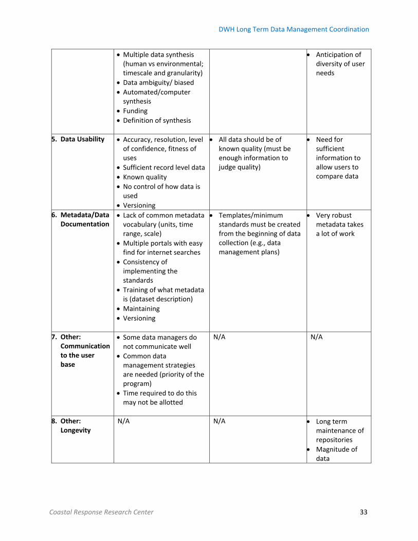
The major challenges identified by each of the three breakout groups are compiled Table 1.
Table 1. Challenges identified by the workshop data managers, generators, and users
Data Managers Data Generators Data User
1. Interoperability Scale of interoperability down to the metadata record
Selective technical data standard
Little understanding or funding that allows meeting a minimum standard
Interoperability should be part of everyday collection efforts
N/A
2. Ease of Discovery & Searchability
Lack of common vocabulary
Multiple portals using a common internet search engine
Web page with different “themes” to help drill down for needed data
Search by “keywords” Design for user experience is difficult
Level of funding available to hire people to monitor the input and sharing of data by generators
Data users should work with generators to determine the needs/search preferences
Data entered in a way that it may be used for visualization by users
Characteristics of a good repository
3. Data Access Paying for infrastructure Data volume
Create a common interfaces for standards
Number/amount of people accessing data (infrastructure behind access)
Restrictions & sensitivity & patents & security; level 2 product can be accessed but not the raw data
N/A Funding
IT security
Confidentiality of data
4. Data Synthesis Better interoperability feeds into better synthesis
N/A Anticipation of user needs
DWH Long Term Data Management Coordination
Coastal Response Research Center 33
Multiple data synthesis (human vs environmental; timescale and granularity)
Data ambiguity/ biased
Automated/computer synthesis
Funding Definition of synthesis
Anticipation of diversity of user needs
5. Data Usability Accuracy, resolution, level of confidence, fitness of uses
Sufficient record level data Known quality No control of how data is used
Versioning
All data should be of known quality (must be enough information to judge quality)
Need for sufficient information to allow users to compare data
6. Metadata/Data Documentation
Lack of common metadata vocabulary (units, time range, scale)
Multiple portals with easy find for internet searches
Consistency of implementing the standards
Training of what metadata is (dataset description)
Maintaining
Versioning
Templates/minimum standards must be created from the beginning of data collection (e.g., data management plans)
Very robust metadata takes a lot of work
7. Other: Communication to the user base
Some data managers do not communicate well
Common data management strategies are needed (priority of the program)
Time required to do this may not be allotted
N/A N/A
8. Other: Longevity
N/A N/A Long term maintenance of repositories
Magnitude of data

DWH Long Term Data Management Coordination
Coastal Response Research Center 34
Breakout Session II
The participants were divided into six groups: interoperability, ease of discovery, data access, data
synthesis, data usability and metadata/data documentation.
1. Interoperability
Interoperability occurs when data sets can be translated from system to system without extensive
transformation. Interoperable data would be a set that blends across archives, repositories, domains,
and sectors and not impacted by formatting, vocabulary, and metadata. The questions posed for the
group included:
1. To whom is interoperability important?
2. Why is interoperability important?
3. How does interoperability happen and who is responsible?
Interoperability is important when crossing data from sector to sector (e.g., using climate data to cross
over to the health sector to answer public health questions). It is important to those synthesizing the
data and using products to answer broader societal/scientific questions. The conclusion to the second
question was that interoperability is important because it supports activities such as synthesis, data
discovery, access, and dissemination. Interoperability promotes interdisciplinary use of data and helps
answer complex questions. The response to the third question was that establishing standards or a
framework for the entire life of the data stream would enable system to system communication. The
system standards could be established within the initial data management plans and possibly by
government agencies.
The breakout group discussed the data management requirements to achieve successful interoperability
and those included: clear plans that follow standards, proper resources and training, a catalogue of
existing frameworks to better understand and establish a common vision across organizations that helps

DWH Long Term Data Management Coordination
Coastal Response Research Center 35
translate data in the future. The group also discussed best practices and guidance for interoperability
concluding that the development of homogenous standards would help promote interoperability
between systems. This would work as long as sectors adhered to standards, and standards were
documented, so that future generators would use the established standards.
2. Ease of Discovery / Searchability
The breakout group discussed three questions specific to ease of discovery:
1. What are the characteristics of a good repository‐ in terms of ease of discovery/searchability?
2. How is metadata quality ensured?
3. How are user needs met?
Characteristics of a good repository include abundant keywords with a common vocabulary, semantic
search, and searchable data all within a “findable” repository. Ensuring the quality of metadata comes
from investment in human resources, an early focus on complete/accurate metadata, and generators
training on proper data documentation. The only way to ensure that user needs are met is to know the
user and their level of knowledge.
Requirements to fulfill successful ease of discovery includes early involvement by the data management
team, definition of user needs, and the ability to edit metadata once it has been collected to make it
easily discoverable. Best practices for ease of discovery includes establishing a federated database,
funding mandates, and identifying end users at the start of data collection.
3. Data Access
This breakout group discussed the meaning of data access, and established that there are subtleties
within that topic that are more complex than just having the data be available. Data access is the
successful endpoint to data discovery; the user can get what they need without a lot of extra work. The
group answered three questions:

DWH Long Term Data Management Coordination
Coastal Response Research Center 36
1. How is restricted/sensitive data addressed?
2. How is data security addressed?
3. What are the options for the data volume challenge (i.e., high volume; large data sets or many
hits on one data set)?
The first question required an established definition; referring to the actual sensitivity of the data (e.g.,
human, archaeological, embargoed data, dark data). The conclusion was: limit the amount of restricted
data, summarize forms/frameworks used by the data generator, obfuscate the GIS, build security into
the system using summarized forms of the data, and roll up the data such that individuals cannot be
identified. There is also the option to create credentials or differential access through log‐in
requirements.
The second question required a specific definition to aid the discussion of a broad interpretation of data
integrity and system security. Again, the group agreed that granularity/credentials/differential access,
and login access roles would be helpful along with meeting common IT security requirements. An
alternative or additional option is certified data warehouses/centers to promote the security and
integrity of data sets.
The third question touched upon the challenges of high volume/large data sets. The outcomes of the
discussion were a scalable cloud. Challenges include the associated cost and procurement. Another
option would be to create subsets or previews of the data prior to download. All of which could combine
with the option to have multiple methods of access (e.g., FTP, direct cloud download, cold storage). It
may also be possible to leverage a private industry to store the data (e.g., Google Earth engine) so that
the data is accessible to the public.
The data management requirements for successful data access include: a common summarization
approach, complete documentation, robust metadata, bolstered public accessibility, and effective user
DWH Long Term Data Management Coordination
Coastal Response Research Center 37
interfaces (human) and services (machine). Best practices and guidance for data access must ensure
data integrity within a system. The system is designed for public access, as well as credentialed logins.
The user interface should be easy to use and share data in an enticing way (e.g., communicate with story
maps). It is also important to give data owners/generators credit for their work including identification
of the generator (as appropriate).
4. Data Synthesis
Data synthesis was defined as bringing together different data sets to do comparisons and analyses. It
requires a multi‐disciplinary approach which is guided by human activity to answer questions beyond
the original purpose of the data. This group altered their original questions to better suit the challenges
of data synthesis. The questions were:
1. How can data discovery and accessibility occur for unknown future users?
2. Why is data synthesis important?
3. How does data management facilitate data synthesis?
4. How can data be preserved for future use?
In order to make data discoverable and usable for unknown future purposes, the data must be
interoperable. Interoperability is reliant upon metadata, key wording, standards, crosswalks, machine‐to
machine‐discovery, and standard archiving formats. Additionally, optimization of web searchability for
data (e.g., Google‐like search) must help all users who do not know about the vast amount of data
available, and market the data so that people can learn of the variety of data sets. Data synthesis is
important because it is used to answer questions (e.g., for the DWH NRDA restoration effort). One
question is whether the resource recovered and the extent to which restoration efforts helped
recovery? Data must be properly managed such that synthesis is easy for data users (e.g., through
transformation and analytical tools). The establishment of an effective archive can enable proper
dissemination of data and aid in the synthesis process. Coordinating synthesis centers and building the

DWH Long Term Data Management Coordination
Coastal Response Research Center 38
capacity for researchers to do the work and use accepted tools would help standardize the synthesis
process.
Data management requirements for successful data synthesis include: direct access to the data,
searchability, consistent metadata, and knowledge/training on repositories and their tools. Best
practices and guidance for data synthesis include: talking to experts, defining potential questions and
knowing the audience.
5. Data Usability
This group defined their topic as making as little effort as possible to execute a task with an end goal of a
usable product (e.g., opening the file, transforming it). Key factors include: attributes and characteristics
of the data, knowledge of biases, confidence in the data quality (QA/QC), and awareness of the data
format and collection methods. The goal of data is synthesis and product creation. Users need the data
sets to be interoperable and ensure that they are extracted in the same or high quality than they were
entered. This group discussed:
1. How the generators can be “encouraged” to define quality, resolution and accuracy of the data?
2. How the quality, accuracy, resolution of the data can be conveyed users?
3. How data quality, accuracy and resolution can be assessed and reported?
The first major conclusion was that data usability must be approached from the perspective of the
funder/repository as well as the data generator. Funders could provide a template/framework that
generators use while collecting data. This system would be established within the data management
plan/contract at the beginning of the process. The generator needs to understand that data
documentation is crucial for synthesis, usability and longevity. The group determined that conveying the
quality, resolution and accuracy of data to users should be done through intensive data documentation.
Information should be conveyed through the repository. This would include a disclaimer regarding the

DWH Long Term Data Management Coordination
Coastal Response Research Center 39
purpose of the data, and why it was created and further background on the data set. Assessing the
quality, accuracy and resolution is challenging because it encompasses the data generator, user and
repositories. The generator must document collection methods with sufficient metadata and the data
must be checked for quality assurance. The user must be able to determine the use of the data (e.g.,
resolution, accuracy) to ensure that it meets the need. Overall, standardization of quality assurance
should be done through a peer review process using the communities of practice. The category of
“other” brought to light challenges that data usability faces. One example of this is defining key policy
questions that need to be answered, and using data to answer these bigger picture questions.
Coordination within the DWH community to enable common metrics that can be aggregated to answer
key policy questions would be helpful when determining which data sets to use. Restoration monitoring
requires a baseline to compare the data pre‐ and post‐incident. Often, baseline data is unavailable which
results in gaps in monitoring efforts.
Data management requirements for successful data usability include: common data descriptors; shared
knowledge and understanding of the data (e.g., robust metadata), and engaging the data users early so
that collection of data is not random and purposeless. Machine readable metadata allows for easier
usability of the data because it enables systems to pull in data without extensive transformation.
Allowing data users to preview data prior to download would reduce strain on the repository and speed
the search. The best practices and guidance recommended for data usability are to: develop
communities of practice, determine if there is a consensus approach across many communities, and
bridge gaps between diverse communities. Creation of a user report that outlines the quality of data and
provides a summary of which standards it meets, and trains users about access via
warehouses/repositories. The repository should consider the user interface and how existing tools can
reduce the struggle between user and data.

DWH Long Term Data Management Coordination
Coastal Response Research Center 40
6. Metadata / Data Documentation
The metadata breakout group created a scope for their discussion, this included NRDA
restoration/RESTORE Act as their primary data of discussion. However, there will be other end users of
this data and therefore the need for quality metadata is even more important to maintain the longevity
of data sets. Overall, it is important that greater value is placed upon archived data sets related to the
research that will be funded in the future. This group answered the following questions:
1. How is the consistency of geospatial metadata standards established and ensured?
2. How is a controlled vocabulary implemented in metadata?
3. How is completeness of the metadata ensured for users in the future?
4. How is the burden of metadata reduced on generators?
The group concluded that if data documentation is done properly then the rest of the data management
process becomes much easier. Establishing consistent metadata standards can be accomplished through
mandate from the funding agency, particularly for tags, supplemental information, and definitions for
data fields. Establishing training for the data generators at the start of collection would help data set
description. The funding agency or repository can assist in data documentation by providing a template
for data generators to complete. Engaging communities who work together to agree on
protocols/procedures and establish a written contract would benefit metadata quality. The contract
would hold data generators accountable for high quality metadata, and help data managers to store it.
Implementation of a controlled vocabulary could be made easier with the use of templates, but first the
community of practice must agree upon the vocabulary.
Creating value for metadata documentation at the start of data collection helps the entire data
management process. For example, generators who have quality data documentation have more
discoverable data, and therefore it can be synthesized on a more frequent basis. Complete metadata is
ensured though a review process (human and automated) with established rubrics. Templates and

DWH Long Term Data Management Coordination
Coastal Response Research Center 41
guidance encourages comprehensive metadata. Establishing a minimum required set of standards
within the data management plan provides generators with clear expectations.
Data management system requirements for successful metadata included complete metadata standards
for all stakeholders. Additionally, when metadata is machine readable or automated it reduces the time
data managers spend on maintenance. Complete metadata allows for more discoverable, transferable
and adaptively managed data. High quality metadata assists with connecting data to the source, and
directing any questions to the data generator. Best practices and guidance for metadata include:
generating metadata continuously, collecting metadata as soon as data collection begins, and
implementing existing workflows (e.g., rolling deck to repository), and listing best practices accumulated
by communities of practice and stakeholders.

DWH Long Term Data Management Coordination
Coastal Response Research Center 42
VIII. Conclusion
Workshop Outcomes
The final day of the workshop included a plenary session where the participants discussed the
outcomes. Participants identified the need to determine the barriers that data generators perceive to
following directives and standards. Any enhancements or improvements to data management systems
should consider the needs of data users. The first step in making more robust data management
systems is a compilation and review of existing data management directives including federal
requirements with respect to data delivery, annotation and documentation for grants. [N.B., This is
already in progress for biological and monitoring standards.]
Moving Forward
During the final plenary session, the participants identified steps to improve LTDM centering on data
management standards, interoperability and data discovery/searchability.
1. Data Management Standards
1. Form a small, short‐term working group to define data management components.
2. Identify categories of standards needed (e.g., data acquisition including sampling protocols and
quality control, data management).
3. Create a DWH LTDM standards working group (DWH LT DMSWG) to determine what gaps need
to be filled for data management standards. The gap analysis will inform the list of standards
(e.g., metadata) that need to be established. This must be done in concert with the RESTORE
Council’s monitoring and assessment work group (CMAWG) and the Cross‐TIG MAM (NRDA)
analysis for data acquisition and monitoring.
4. Provide feedback to funding entities on standards needed to manage data long term that are
recommended by the DWH LT DMSWG, CMAWG and Cross‐TIG MAM working group.

DWH Long Term Data Management Coordination
Coastal Response Research Center 43
2. Interoperability
1. Create a working group to determine what could optimize interoperability efficiency between
DWH LTDM systems and drive collaboration among them.
2. Compile strategic goals and key features for data warehouses and repositories.
3. Determine the intended, current and future use of DWH LTDM systems.
3. Discovery/Searchability
1. Develop and share technology used by DWH data management services for keyword, semantic,
geospatial, and temporal searches.
2. (In parallel with 1.) Create a community driven, vocabulary working group to identify definitions
for specific data types as well as incorporating keywords into data and metadata.
a. Populate with individuals from the NRDA TIGs and RESTORE Act communities of practice
as well as DWH LTDM workshop participants.
3. Leverage architecture of existing systems where possible (e.g., USGS Sciencebase, NOAA
OneStop).
a. Compile approaches regarding data, links, and metadata (e.g., embedded ESRI maps
that delineate study areas).
b. Note whether date is service‐enabled (e.g., machine readable, consumable by other
programs) because serviceability enables interoperability.

DWH Long Term Data Management Coordination
Coastal Response Research Center 44
Appendix
Appendix A: Workshop participant list
Appendix B: Agenda
Appendix C: Presentation slides
Appendix D: Pre‐workshop survey
Appendix E: Flow diagrams
Appendix F: Breakout session templates
Appendix G: Breakout group participant list
Appendix H: Breakout group notes
Appendix I: Funding Diagram