;e}·, ./) a preliminary report oii,:tl'e mineral springs of...
TRANSCRIPT

SOUTHERN RHODESIA.
GEOLOGICAL SURVEY BULLETIN
No. 23. / /I'
' < l · ..
/-:" \.<~--~, I
··.,, -.,._(, \ . !
\;E}·, _./) "'- r '· ·- ~
''-.,,~: I,·.;· :"- -,,' __ ,:.-/
A Preliminary Report oii,:tL'e Mineral Springs of Southern
Rhodesia.
By H. B. MAUFE, l\i A., F.G.S.
lf'SUED BY AUTHOIUTY,
CONTENTS.
PAGE Introduction 7
Previous investigations 7
A list· of mineral springs in Southern Rhodesia and close to its borders 8
Distribution of the mineral springs 11
~rheir relation to the geological structure 11
r:rhe origin of thermal sp.ringR 13
The depth of origin . . . 13
The Hature of the:> mineral spring waters 15
Southern Rhodesian mineral spring waters classified by composition 17
Analyses of some European and South African mineral w~n W
Table of distribution of classes of mineml waters 22
Temperature of the thermal springs 22
Rate of flow 23
Deposits from the mineral springs 23
'l'he individual mlllc>nd spnngs 24
List of rcef<'rences 74
b~x %
ILLUSTRATIONS.
P,late I, A. The main jet at the Kabira OJ.' :0ongala Gushers, No. 3701, Sebungwe District ... FACING PAGJC 28
B. The maiJJ jet at the Chipiso Thennal Springs, No. 3601, Lornagnndi District
Plate II, A. Chilambwa '.rhermal Springs, No. 4403, Makabuka District, Northern B,hodesia .
B. rrhe Blain eye at ~~~rhe llot Springs," No. 3102, in the Sabi valley, Mutambara Native Iteserve, Melsetter District
Map of the Mineral Springs
" 28
67
" 67
AT THE E~D
A Preliminary Report on the Mineral Springs of Southern Rhodesia.
IXTRODUC'l'ION . .Not much .interest has been taken up to the pre~cnt in
the mineral spriugs of Southern Rhodesia, and certainly ver~ iii.tle use has heen made of them. Exceptions to the latter statement are the use of "The Hot Springs," Mutambara, and to some extent. the Rupisi hot spring in the same district, for health purposes; the experiments to extract com:oi~rcial salt from the Nichenge brine springs; and the use of the dilute Sunga springs to form an important part of the 1Vankie water supply. Apart from the above the natives extract a. salt from some of the spring waters or from the vleis into which they fl.ow, and perhaps nse some for medicinal purposes.
PREVIOUS INVESTIGA'l'IONS.
'l'he first accpunt of an exact natu,·e of any Rhodesian springs w·as given in a paper by D. J<'erguson (1) in 1902 . .A. J. C. Molyneux (2) and :F. P. Mennell (a) made contributions soon afterwards.
Since the inception of the Geological Survey information <>o<m• the springs has been collected as opportunity offered,
·'·''"' ·.; .• ,A B. Lightfoot ( 4) recorded observations in Bulletin No. :.{,?,,'f;.~~fi'.e'ldThe Geology of the North-Western Part of the W ankie i ''
ge~eral information gathered was collated in 191G sent to Professor M:. M. Rincll (5), Grey University
Bloemfontein, who made use of it in his paper on Springs of South Africa."
Thermal springs, the location of which was known, were marked on the Provisional Geological Maps of Southem Rhodesia (6) published in 1921 and 1928 respectively .
. A further systematic collation of tho information on the Geological Survey files was made by Mr. S. C. :Morgan in 1928, and this information was sent to Professor ltindl (7), who made use of some of it in one of his supplementa1:y papers on the medicinal springs of South Africa. Mr. Morgan's compilation has been thoroughly revised and Qrought up to date.
In this work the writer has had the assistance of Mr. K Golding, Chemist to the G8ological Survey, who, apart from contributing the original analyses, has re-calculated the .{)lder analyses to those of the International Standard M:easurements.

A LIST OF MINERAL SPRINGS IN SOUTHERN RHODESIA AND CLOSE TO ITS BOIWERS. 0
No. Name.
LO.i\Ll.GUNDI DISTRICT.
2601 Ohipiso thermal sprmg
260~ 2603 2604
3101
3102
;)103
3104 3105 310G 3107
:Mendayatswa oo~e Kalishe swamp 'I'hermal sprmg
}lELSETTER DISTRICT.
M "·engezi thermal sprmg·
"The Hot Springs," Mutambara
Rupisi hot sprmg
Sldphurous spnng Dunstan spring Chimanimani g!lyser Chiwichuhagwe thermal
sprmg
SEBUXGWE DISTRICT.
Solids. Parts per
million.
13.21
108:-3 2234
368
389
273
3'1'01 Kabira (or Zongala) gusher., 622
~l702 Lubim hi thermal spring 1290
Chief ions.
SO, Na.
soc!, Na. SO., Na
HC03 , Na, some H 2S
ROO, Na, some H 2S
ROO,, Na, some H 2S
Some H 2S SOu Na, Ca
Cl, K, some H 2 S
01, co, SO, Na, some H 2 S
Temp. °C.
hot
CirC. 50° cold
62°
cold tepid ? hot ? hot
hot
Height above sea level. Formation and deposits.
1270 1350
2050
2000
1680
Gneiss near dm.vn-faulted Karroo beds. Calcareous sinter and salt deposited
Karroo beds ? faulted Karroo beds
Near fault m Archaean granite
Fault between U mkondo beds and Archaean
Gneiss perhaps near fault
? Archaean U mkondo beds ? Frontier system Intrusive contact of gran-
ite with Karroo basalts
20Hl Karroo beds
below Karroo bed~ :3000
0
"'
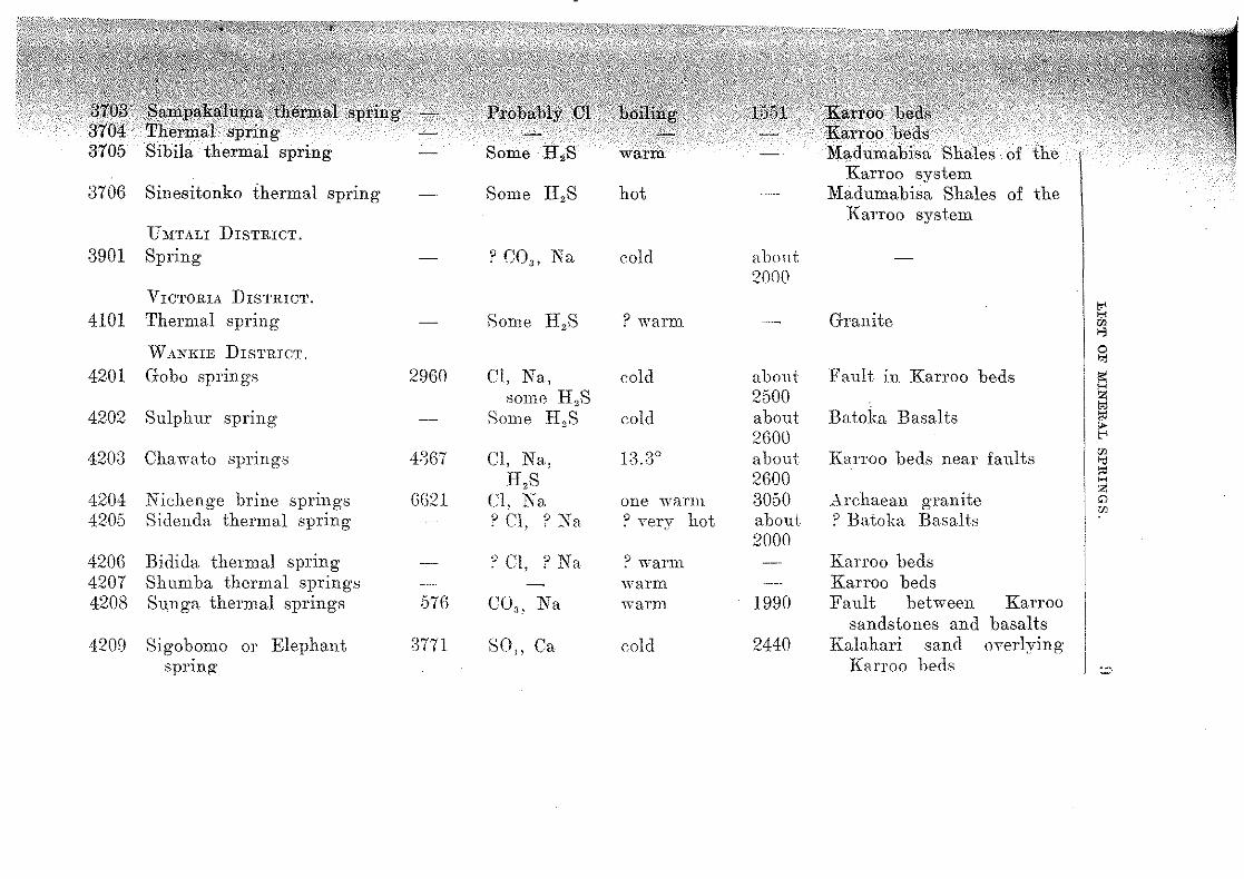
3706 Sinesitonko thermal sprmg
U:;rTALI DISTRICT.
3901 Spring
4101
4201
4202
4203
4204 4205
420G 4207 4208
4209
VICTORIA DISTRICT.
Thermal sprmg
WANIGE DISTRICT.
Gobo sprmgs
Sulphur spnng
Chawato sprmgs
Nichenge brine sprmgs Sidenda thermal spri~g
Bidida thermal spnng Shumba thermal spnng·s Sunga thermal springs
Sigobomo or Elephant sprmg-
29GO
GG.2l
57G
:nn
Some
Some H,S
? CO,, Na
Cl, Na, some H 2S
Some H 2S
Cl, Na, H,S
Cl, Na ° Cl, ? Na
9 Cl, ? Na
CO,, Na
SO, Ca
hot
cold
? warm
cold
cold
one warm ? Yery hot
? warm warm warm
cold
abont 2000
about 2500 about 2GOO about 2GOO 3050 about 2000
1990
2440
of the Karroo system
Madumabisa Shales of the Karroo system
Granite
Fault in Karroo beds
Batoka Basalts
Karroo beds near faults
Archaean oTanite b
? Batoka Basalts
Karroo beds Karroo beds Fault between
sandstones and Kalahari sand
KmToo beds
Karroo basalts
oYer lying

No. 4210 4211 4212 4213
Name. Sigobonya thermal spring No. 9 bore-hole water Chigwadada thermal spring Sakabika thermal spring
Solid~ . . Parts per
million.
732
Chief ions.
SO.u Na
Temp. °C. ? hot cold tepid warm
BECHUANALAND PROTECTORATE near the Sc;uthem Rhodesia border. 4301 Nungwe thermal spring 10802 Cl, S0,1 , Na warm
4401 4402 4403
4404 4405
4406 44.07 4408 4409
4501 4502 4503
N OitTHERN RHODESIA near the Zaml:ezi rner. Thermal spring ? Cl, N a Chilunclu springs Chilambwa thermal sprmgs ? Cl, N a
Manzaia thermal spring Kapesa (or Chatenta) ther-
mal spring Spring Spring ( ? gusher) N akuyu springs Kabwili ooze
s, ? 01, Na
? Cl, Na ? Cl, Na
hot 31° goo
66° 73°
? tepid 32° 21°
PoRTUGUESE EAsT AFRICA near the Southern Rhodesia border. Thermal spring Thermal spring Shai va thermal spring
Height ul>ove sea level. Fonnation and deposits.
? Basalt 2295 Karroo beds
Karroo beds Archaean granite
? Batoka Basalts
Batoka Basalts ? Karroo beds. Some sinter ? Basalt. Some sinter and
salt ? Karroo beds Karroo beds. Some sinter
Sandstone Some travertine deposited Karroo beds ? Karroo beds
? Frontier system ? Karroo beds Karroo beds

JHS'l'lUBl'TIO;"i <H' THE IMI1\ElL\L Sl'lll.'it:;-;. 11
OF THE MIN.EUAL SPRINGS. thirty-two localities have been reeorded in South
•1i .f{:hcoue,sJ·: 1, but as the issue of mineral springs knows boundaries and as a number iss1w just without
of Southern Rhodesia, partieularly on the left the Zamhezi river, such information as has been
about another thirteen springs closely related to 'i/:'thO$e. issuing in Southern Rhodesia has boen ineluded in the
list. The localities of all these springs have been plotted 011
.WC,>the\nrap at the end of the volume. It shows their distJ·ibua striking way: namely, a group aligned so11th-west
down the Zambezi valley and another one north to south down the eastern border. 'l'here is
' ·> "•M"'" ·· evidence for an east to west line of springs on the !!:J'igbrt flank o£ the Limpopo valley in the northern Transvaal,
appears to he only one of this group recorded as within the area of the map: namely, the Stindal
i~!i;rn1g east of Ithod.es' Drift (Rindl, 5) about which no furis available. 'l'he only recorded exception
remarkable distribution is the small thermal spring, on the right hank of the M tilikwe river south of Fort
THEIR RELA'l'ION TO 'l'HE GEOI,OGICAL STRUCTURE.
It may he said at once that the two groups issue in thosf' areas in which faulting and the displacement of blocks strips of the earth's crust have taken place in times
. '·'"'~'" than the outpouring of basaltic lavas at the end o.f the < ][:l,:(.fo,o period. It is in. the same two areas that slight earth
;(ii i!J.J.ia')!:e· shocks are felt more often than in other parts of the Before the age of the lavas was established, and
.·:::. yu",Y' were thought to be of 'l'ntiary age or even younger, hot springs were believed to represent the closing· phase
period of volcanic activity. It now appears that }~J~~l:e is no conn0xion between the extrusion of the Karroo
: ... ·.•··· 'J.;l.Ya.s and the present day hot springs, and the origin of the <·;.taJc.ter must be sought in other directions .
. The chief known faults of post-Karroo age are shown on and it is very evident that there is a close corre
•c ;j)J!()Ilfl(lll<)e between the distribution of the mineml sprmg·s of the faults. 'rhis is well shown in the country
cn:c~~'<l.Ullld Wankie, which has been mapped in detail (4, 8).

12 1CELA'I'T02\ TO TilE {)EOl.OUlCXL STRUCTFlU<:.
Here the Sunga thermal spring may actually be seen to issue from the fault fissure. '"l'he Hot Springs" in the Mutambara Reserve also issue on or dose to the line of a powerful fault.
'fhe effect of the fault,; in the Zambezi valley has been to throw down strips or blocks of Karroo beds to lower levels. l<'requently a suite of more or less parallel faults throw., down the beds in a succession of steps, b11t in places a strip of country is let down in to a trough between opposing faults. In the list of springs it will be noticed that a large majority of those belonging to the Zambezi group issue from the sed.iments and lavtts of the Karroo system. The exceptions whieh issue from Archaean rocks appear in or in the vicinity of down-faulted blocks or strips of Karroo rocks.
The thickness of the Karroo sediments in the vVankie District is bss than 1,700 feet (8), and this thickness is not likely to be greatly increased down the Zambezi valley. It will he shown later that many of the thermal springs musi arise from mueh greater depths than 1,700 feet. They must therefore arise in the underlying Archaean complex. The fact that in the foregoing list so many springs are noted as issuing from Karroo beds is not to be taken as indicating a direct association of the mineral springs with the Karroo system. '!.'he connexion is between the mineral springs and the belts of faulted country, that is, with tho geological structure, not the g·eological formation. A case in which the influence of the Karroo formation has determined the character of a mineral spr.ing water is that of the Sigohomo spring, 4209, discussed in the final section of this bulletin.
'l'he M:elsetter District is stepped down towards the west by two powerful faults trending north and south. 'fwo of the bettor known .-;prings issue from, m· in dose proximity to, the more westerly fault. 'l'h~l line of the eastern fault and the position of the springs in its vic.inity is too little known to make any definite statement on the relat.ionship. Both faults a:ffect the dolerite sills which are intruded not onl~·
into the Umkomlo beds hut into the Karroo rocks situate<] to the west oJ the Sahi valley. 'fhese faults are therefore, so far as we can tell, of about the same age as those of tlH' Zambezi valley. Both series are apparently an extension of the more intensive movemento which took place at intervals throughout several geolog·ieal periods in central and east central Africa, and culminated in the formation of the wellknown Rift Valleys of that region. The volcanie activity
ORIGIN OF TilE THVltM.\L SPJUSGS.
\vith those movements, which probably comUpper Cretaceous times, has extended throughout
i:\r•tit1ry and is not yet at an end as is evidenced reee1atly active volcanoes of Teleki and Donyo N gai.
more reasonable, therefore, to conneet the earth Yt\lU~Jilts and thermal springs oi the Zambezi valley and of
border with the earth movements, volcanoes, etc., of east central Africa than with tho much
Ol(.l!lr ll'en.ou of volcanic activity in late Karroo times.
~--,.-ORIGIN OF THE 'rHERMAJ~ Sl'IUNGS.
·········'l'·=n distinct hypotheses have been pl\t forward to account •it!J.t<tll.e origin of thermal springs. In the one it is thought .t)l,:.t};jn thes!) step-faulted and trough-faulted regions which
th!lref()r·e subject to tensional stresses, there are :fissures, }V;pe'l;Jiier :fissures or not, penetrating sufficiently deeply
earth's crust and sufficiently open to permit the perof waters from the surface. The water is thereby
to the required tempmature and may he brought .to (.81).'!'fa<Je again largely by hydrostatic pressure, but partly
On this hypothesis thermal springs may be to issue· generally on relatively low ground, and
appears to be the case in this country. Of whose altitude has been ascertained, only one the 3,000 foot contour, whilst it is estimated
·thirds of the country lies above this altitude. A issue either somewhat above or a littk below the
contour, and in this connexion it is to he remem-~iG.hatvery little land in Southern Rhodesia lies below
· contour.
water acts chemically upon the roeks it moves, and dissolves some of its constitu
water is naturally more active chemically, can more constituents and generally much larger qnan
,.,.,. them. The mineral content of thermal springs is, on under discussion, obtained from the rocks
.1\Q'l\g:hw)ilicdt the water moves on its downward co1trse, but on its ascent to the surface in a heate<1
Depth of 01·ig1:n. It is well known by reason of the ;p!J,¢t:atltre attained by the rocks in deep mines and bore
the temperature of the earth's crust rises at a fttl:l.i.form rate as one descends into it. 'l'lw water which
)!J~1it.ters deep into the crust must reach almost exactly the

1-1
temperature of the rock in which it moves before beginning its ascent. If we know the rate of increase of temperature (thermal gradient), it is easy to cnlcula.to the approximate depth from which a hot spring rises.
depth of origin 'l'emp. of spring = mean ann. temp. + ------·
depth for diif. of 1 deg. 'l'herefore, depth of origin · = temp. of spring - mean arm. temp. x depth for di:ff. of 1 deg.
'l'he thermal gradient in this eountry is known from observations made in the Globe and Phamix Mine to be one degree Fahrenheit for 119 feet in granite country (9); that is, for every 119 feet of depth below the surface the temperature of the rocks rises one degree Fahrenheit.
The mean annual temperature at the spring must be calculated by allowing a r1sn of three degTees :Fahrenheit for every 1,000 feet decrease of altitude below the nearest meteorological station .
. In the case of "The Hot Springs," Mutambara, 3102, which lie 3,500 feet below JVIelsetter with a mean annual temperature of 62.9 degs. }<'., the mean annual temperature may be taken as 62.9 + 10.5 = 73.4 degs. F. As the temperature of the hot eye is 133 degs. F., the depth from which the \va ter rises is :-
133 - 73.4 x 119 = 59.G x 119 = 7,092 feet. For the Rupisi hot springs, 3103, and for the Kabirn
gusher, ;nlll, tbe depths of origin appoar to be approximately 8,300 and 15,300 feet respectively ..
It is very difficult to imagine conditions in which fissme.c; would remain so persistently open as to allow surface waters to percolate to these great depths continuously.
The second hypothesis on the origin of the water of thermal springs is based on the fact that all igneous rocks, including granite and other deep seated rocks that only appear at tho surface through erosion of the rocks overlying them, contain water in appreciable amounts. Further, water mainly in the form of steam is given o±l' copiously during volcanic eruptions and escapes in douds from molten lava as it solidifies. It is not necessary to assume that the wator of thermal springs is meteoric (surface) water which has desee11ded into the crust and been retunwd to the surface. It may have been a. constituent of the molten magmas of the interior. Such waters which are thought to have reached the earth's surface for the first time are known a,<; J·uvenile waters . ,
,vith meteoric waters which have penetrated from are known as vadose.
e cliwtributio,n of the mineral springs in Sou them Rho-,,,,,, "n" faulted r,egions, which appear to be a prolonga
more intensely faulted regions situated to the which volcanic activity has been rife and is not yet is quite in accord with this hypothesis.
thEJ temperature of the rocks forming tlie walls of the is rais(Jcl by friction clue to fault movements or by an
t;le~l:\ring body of molten magma which has moved up from depths, then the thermal gradient is increased, and
of origin of the springs will be less than that by the formul2. given above.
waters of all springs and of the underground reser, from which they issue contain some mineral matter and
gases in solution. The waters of mineral springs are by a notable amount of these substances in
The dividing line between mineral springs and •i':din2try springs is thus purely arbitrary. It is often taken i{,)l' C()n'veJ:ne>nc>e at a tenor of one gram of dissolved solids per
70.15 grains per gallon). In terms of the 1mits for use by the International Committee on
Measurements in 1929 (10) and used throughout one gram per litre is, of course, Tepresentecl by
plJ;rts of solids per million. On this basis it will hf' ,,,m""' a, number of the springs, for example, the Sunga tS,,_!lcOin which the water supply of Wankie is drawn in
strictly speaking not a mineral spring, hut it is coHtQ class this and other thermal springs as mineral
will he seen that all the waters are weak solutions, thi,, .u,,n,·.u noticeable in those in tho Melsetter Dis-
ThEJ three strongest solutions here recorded are tlw V.l],gwoe spring just within the Bechuanaland Protectorate,
. b<Jl'€•-h•ole water at Wankie and the water from the warm Nichenge brine springs. 'rhe last mentioned, with
W'lln«l'1c~ of dissolved solids per million, has only about one> strength of the same brine eollected from the
~ll)p:rrtentt shaft in the vlei below the spring and containing per million. This brine has, no doubt, beell by. evaporation, and it is likely that the same
J.() NATDI!lc OF TilE CIHNERAL SPHJSG WA'l'El!S.
process has acted on No. 9 bore-hole water, for at times it reaches to a foot below the surface.
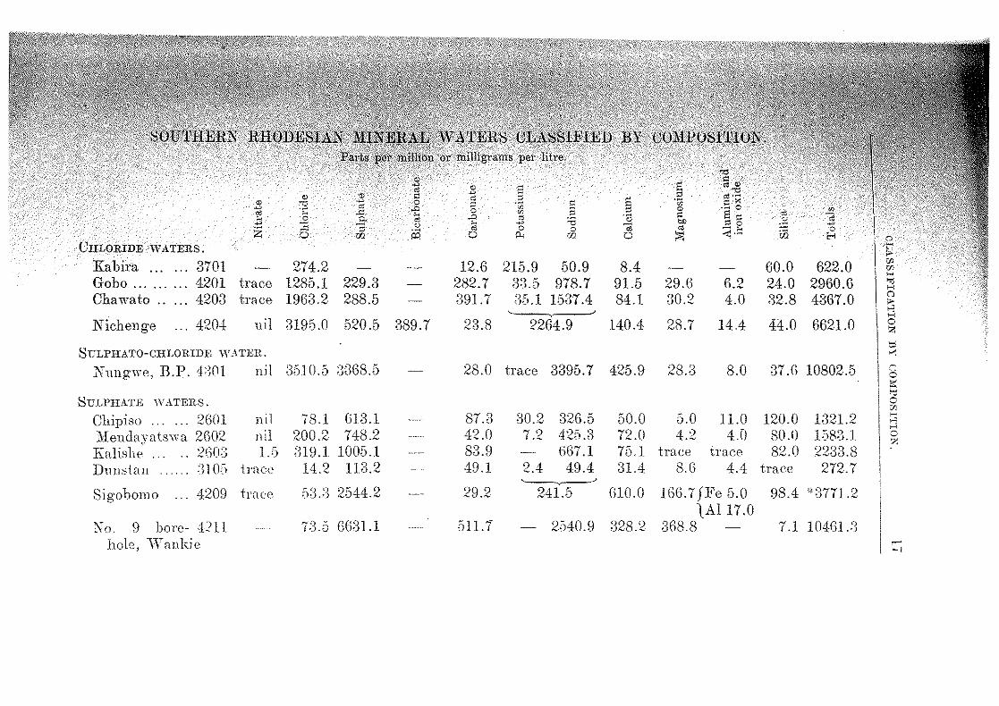
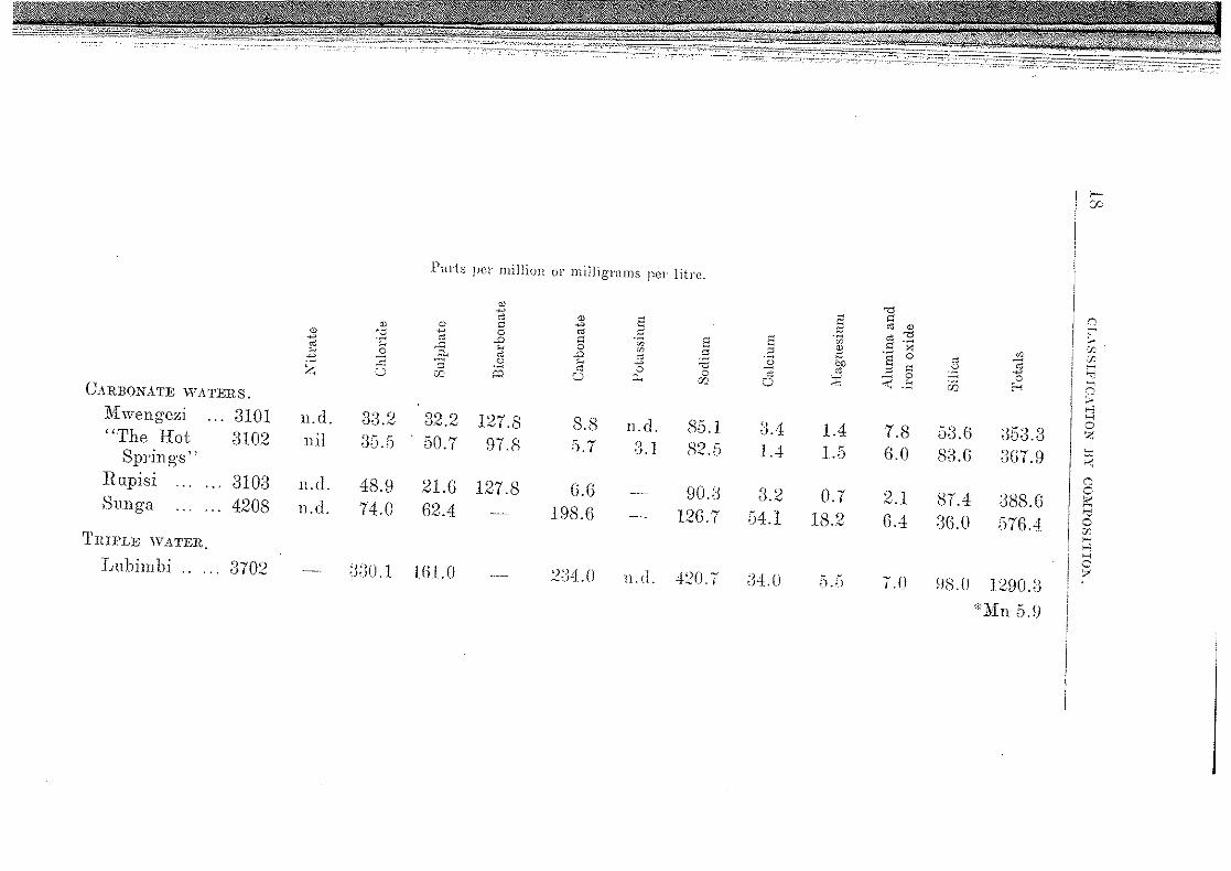
It is usual to classify a mineral water according to the dominant non-metallic constituent, acid radicle or anion dis,;olved in it. The mineral springs of Southern Rhodesia thus fall into three main classes, namely: chloride waters, sulphate waters and carbonate waters. A fourth class contains the mixed or indifferent waters, that is, those without one predominant anion. Any of those waters may also contain sulphuretted hydrogen (H,S), easily recognizable by its smell of rotten eggs. This gas is recorded from twelve out of the thirty two mineral springs, as follows: :n01, Mwengezi; :ll02, "The Hot Springs," Mutambara; 3103, R11pisi hot spring; 3104, spring; 3701, Kabira; 3702, Lubimbi; 3705, Sibila; 3706, Sinesitonko; 4101, Thermal spring; 4201, Gobo; -t202, Sulphur spring and 4203, Chawato. The presence of the gas sometimes forms the criterion for a class of "sulphuretted waters," but the quantity in Rhodesian waters is always small and the above group manifestly comprises waters of diffenmt types.
Chalybeate waters rich in iron compounds undoubtedly occur in Southern Rhodesia, but there is not suifi.cient known about any of them to bring them into this account.
Another class i.~ that of the silicated waters cou,taining siliea wh!ch is deposited in the form of siliceous sinter. Apparently the Kabira gusher (3701) is th!3 only Southern Rhodesian spring which deposits any appreciable amount of .,ilieeous sinter. 'l'he three thermal bicarbonate waters, :J10lf3, from the :M:elsetter District are comparatively rich in silica, doubtless owing to their relatively high content of alkaline bicarbonate.
No estimation of the radio-activity of any of the mineral sp1·ing waters appears to have been made.
"' " " s s " " '"" " ~ .e .,._
" ~ " s " :-s ~ ·;: s w .s B ~ ~ 0 .8 " w
" ~ -" w " " s, "' ..,; '"' .2 .? ..0 ~ 'i3 " ~ ~ ;; ~ ..,; bl)
" 0 ~ z 5 " 0 0 " ~-~ w 0 w. 0 /0.; w 0 "'" ;,..;
"' '"' CHLORIDE WATERS. t" ;..
Kabira 3701 274.2 12.6 215.9 50.9 8.4 60.0 622.0 "' ... ... w H
Gobo 4201 trace 1285.1 229.3 282.7 33.5 978.7 91.5 29.6 n.2 24.0 2960.6 '"" ... ... . .. H
Chawato 4203 trace 1963.2 288.5 391.7 36.1 1537.4 84.1 30.2 4.0 32.8 4367.0 () .. ;.. .., H
Nichenge 4204 nil 3195.0 520.5 389.7 23.8 2264.9 140.4 28.7 14.4 44.0 6621.0 0 !>I
8 ULPHATO-CHLORIDE ::;:;
\V,\TER. ,..,
Nungwe, B.P. -:t:JOI nil :];').10.5 :};)68.5 28.0 trace 3395.7 425.9 28.3 8.0 37 .n 10802.5 0 ,., ;:;
SULPHATE W.\TEHS. 0 v::.
Chipiso ... . . . 2601 ll i 1 78.1 613.1 87.3 30.2 326.5 50.0 6.0 11.0 120.0 1321.2 '""' >-< :Mendayatswrt 2G02 nil 200.2 748.2 42.0 ~') 425.3 72.0 4.2 4.0 80.0 1~,s:u 0 I·- 7. Kalishe ... 2G03 lJi ;n9.1 1005.1 83.9 667.1 75.1 trace trace 82.0 2233.8 Dunstan 'll 0:1 trace 14.2 113.2 49.1 2.4 49.4 31.4 8.6 4.4 trace 272.7
...__,._~
Sigobomo 4209 trae:e 53.:3 2544.2 29.2 241.5 610.0 166.7 fFe 5.0 98.4 *:nn.2 1All7.0
]'\ (). 9 bore- 4?11 ·-·) - ()();31.1 511.1 - 2!540.9 328.2 368.8 7.1 10461.3 I •.>.0
hole, \Vankie _,
Parts per million or milligrams pei· litre.
" "" " ~
" " " " 8 OJ " '" " " ~
"' '"" ;.. "' -~ OJ <D ~ 0
" s " " ·x :Z· ~ " ..Q
~
~ " '"' '"" '"' 0 ~
" "' § 0 OJ ~ cr. '"' ~ '" " ..Q .J ] ~J) .s "' ~ ~ -; .s '"' ""' "' " ~ " 2 0 "' ~ :;;:: 0 0
~
/'; ·~ ,:r;; q ':J 'X! 0 ~ ~ us ~ ;::. ;..
CARBONATE WATERS. e-; H Jlii wengezi 3101 u.d. 33.2 3.2.2 127.8 8.8 u.d. 85.1 ') .'"'" ") '.) 0 0.4 1.4 7.8 50.6 UOU.o:_) Y, "The Hot 3102 11 il () .- r- :)0.7 97.8 !5.7 :u 82.5 1.4 1.5 6.0 sa.n 367.9 ~
uo.n ~ Springs" (';
0 Ilupisi 3103 n.d. 48.9 21.6 127.8 G.6 90.iJ 0 ') 0.7 2.1 87.4 388.G "' -~
""' "' Sunga. 4208 n.d. 74.0 62.4 l98.G 126.7 :)4.1 18.2 6.4 %.0 ;)76.4 0
'l., H
~ TRII'LE WATEJt.
~ .~
~ Luhimhi .. . . . 370.2 :no. 1 ](i].() 2CJ4.0 n.d. 420.7 ;)4. 0 ;) .:) 7.0 ~)8 .l! ] 29().:)
*:Mu 5.9
OF THE 'lllXElUL Sl'Hl:\Ci \YATlW.S. HJ
out of the thirty-two recorded mineral thorn Hhode~ia have been analysed and one analand Proted:orate near the Southern Hho
'l'hese are classified in the foregoing iahlP in 'lF'W.lll'-'11 allows easy comparison.
tuJc<:<•· chloride waters from the \Vankie Distriet com;r'nlif.onn group of weak brines. The high potassium
the Kabira gusher, 3701, i.-; noteworthy. /)~WlOllLg. , the six sulphate waters the three from the lltltUJ1(!]. District are closely comparable. The Sigobomo
4209, has calcium predominant over sodium. 'l'his the Kabira gusher, a7lll, are tlw only exception;; th;tt sodium is the predominant metallic radiele or
the Southern Rhodesian mineral waters. In ,nrvw 5 · this spring it is pointed out that the mineral con
wat<:Jr is probably derived frmn the underlying •o""" great depth. H. is probably a vadose water, and
exphnmtion may apply to the Dunstan Bpring, il1CJ!"1. three bicarbonate waters (;3101/3) from the line of fault are also closely eomparable, a.ncl noteworthy
, ,.~-··- high eontent of silica. 'J'hese three springH have the anw1:er,sassigned to juvenile waters. The t.ablo is not free
slight ambiguity due to the different wt<ys of statof a carbonate water. 'l'he carbon dioxide
)t\re:poll't.ed in terms of the bicarbonate ion (HCO,) in whieh larger qur,ntities of calcium, magne
and silica may remain in solution, or it may be the carbonate ion (CO,). In the latter case the
""''"the analysis is eons.iderecl from the point of view hv<h<m.~ residue obtained from the evaporation of the
sueh a residue 110 biearbonatc would exist, with exception of sodium bicarbonate in certain eiTCmm
It has been thought best to quote the analysis i11
given originally.
l,uhimlJi thennal spring, ;H0:2, :-eems best classified ~1; jt'l'!J)le water.
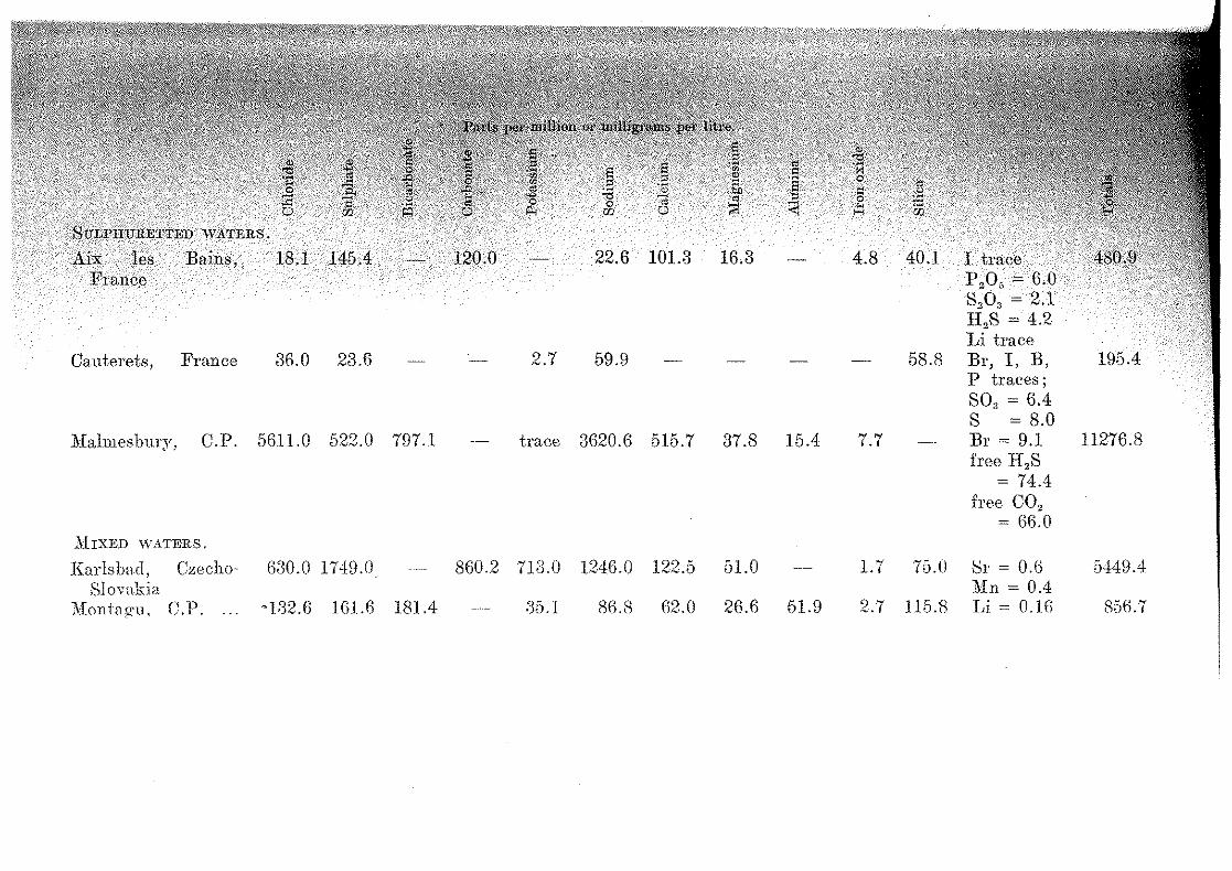
the following table some analyses of well-known cj:'ijpean and South African mineral springs are quoted fm
The data for the European springs have been J.:i:rr.tom de. Launay's "Recherehe, captage et amenagement
thermo-minerales" (Paris, 1899); those for the <.<:1;~1'""n springs from Professor Rincll' s papers ( 5, 1),
where nec.essary, to the .standard units used

ANALYSES OF smm EUROPEAN AND SOU'l'H AFIUCAN .MINERAL WATERS. Parts per million or milligrams per litre.
" ~ ~
" " " ~ " " co " " ~
::$ " ~ 0 "' " 2 ·w .B -~ 3 ~ .-" g ·;; ·S " " 0
.:!2 ~ ~
" S:n s " ~ :§. "' .-" " ] -~ ~ -~ ~ ~
6 " " .ji " 0 " ..,.. ::<: ~ U3 0 0 ;:Q 0 "' w Ci r< E-< CHLORIDE WATERS.
Kissengen, Bavaria 96050.4 20.7 63.286.8 159357.9 \Vies baden, Prussia 4670.0 60.4 260.4 70.1 2695.7 370.8 53.[3 60.4 Br, I, :Mn, 8241.1
Li traces \Varmhad, S.W.A. 7077.0 5452.0 426.8 95.7 5489.2 1632.2 .5.5.0 9.1 12.0 831.5 NOs trace 21080.5 ~ULPHATE WATER.
Bath, England 167.1 1264.0 108.7 432.7 58.5 2031.0 CARBONATE WATERS.
Vichy (Hopi tal), 340.3 176.3 2140.0 1020.0 170.0 18.54.0 160.0 1.2.0 60.0 Li = 1.0 .5953.6 France As20, = trace l\0, = 20.0 \Vannhaths, Trans- 850.0 110.0 950.0 90.0 1210.0 ] 10.0 trace Li trace 3320.0 Yaal
CHALYBEATE WATER.
\'n le-(lon, \'.l'. 897.6 139.2 225.7 210.fi 9s.n fl7 .1 :{2..4 8(-).4 134.4 139Vl
.I
!
i .' 1·.,;
' ,,I·
():
I' ' ,,
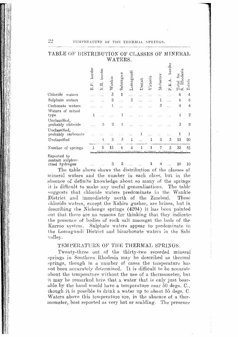
'l'A'BLE OF lllSTRIBU'l'ION OF CLASSES 01<' MINEllAij WATERS.
Chloride \Vaters
Sulphate waters
Carbonate waters V\T aters of mixed type
Unclassified. probably cJiloricle
Unclassified, probably carbonate
Unclassified
Number of springs
~
" "0 ~
0 ..0
~ ~ ,..,
1
1
~
" "0 ~ 0
"" "' ~
" ~
:.:;; OJ)
" r:ii " " " ..0
z ' ~ " U)
3 1
2 1
1
5 2 1
4 5 3
g 13 6
"0
" " bO
" " 8 ~
s >-< ~
3
1
1
4 1
.~ ~ 0 ~
"' :;
1
1
1 3
3
7
4
6
4
1
3
1
4
6
4
2
8
1
3 13 20
3 32 45
Heported to contain sulphm:~ ctted hydrogen 3 2 1 4 10 10
'l'he table above shows the distrib11tion of the dasses of lllineral waters and the number in each dass, but in the absence of definite knowledg-e about so many of the springs .it is difficult to make any useful generalizations. 'I'he table ,;nggests that chlmide waters predominat(;) in the \Vankie District a11d immediately north of the :0ambezi. 'l'hese chlorido waters, exeopt the Kabim gusher, are brines, but in describing the Niehenge springs (4204) it has been pointed out that tlwro are 110 reasons for thinking that they indicate· the presenc<e of bodies of rock salt amongst the beds of the Il:arroo sysh'm. Sulphate waters appear to predominate in the I,omagundi District and bicarbonate waters in the Sabi Yalley.
TKiifl'ERA'.l'l'ItE OF THE '.l'HBRM:AL Sl'HINGS. '.l'wenty-three out of the thirty-two recorded mineral
.,pring-s in Southern Jl.hodesia may be deseribed as thermal springs, though in >l number of eases the temperature has not been accurately dPtermined. It is diffieult to be aecuratP about the temperature without the use of a thermometer, bui it may be remarked here that a water that is only just hearable by the hand would have a temperature near 50 clegs. C., though ii; is possible to lhink a water up to about 65 degs. C. Waters above this tempemture are, in the absence of a thermomoter, best repmted as very hot or scalding. The presence

lUTE OF FLOW.
gas frequently leads to these waters being as boiling.
composition the difference between a. mineral ordinary spring has to he taken at some
so in temperature a thermal spring is usually ;r:c··<>••loit••n·r·i as one having a temperature of over 20 c~c .. Jiji:S degs. F.).
recorded water is the potassium chloride 'OI ute. Kahira gusher at 97' degs. C., which is very near
point of water at the altitude of the gushPr. ~!'ht• '!o>c\'"""'J.bonate water of the Rupisi hot springs nppem·s
owing to the evolution of g·as, hut its tcmpern-62 degs. C. 'rhree of the group issuing jusi
northern Rhodesia border in the region of tlw have temperatures higher than the latter.
of temperature to depth of ongm of tilt• already been discussed.
RATE OF FLOW.
I1ow has been measured m only n very few
Hot Springs," Mutambnra (3102). about a,;lOil guc11u•u~ per hour;
l<.mwa thermal spring (4207'), estimated 5,000 to 10,0011 per hour;
~asriJl'in!!' ( 4208), not less than 25,000 gallons per
(37'01), il,GOO gallons per hour; th<>rn'H1.1 spring (37'02), estimated 2 to 4 eusecs,
45.,500 to 91,000 gallons per hom. <ttiO.v'e includes some of the larger springs. Thl' i r
compares well with that of some of the wcll:I!l1lro,pe.an mineral springs.
FRO:NI 'l'HE MINEHAL SPRINGS. deposited by mintwal waters on reaching-
fall naturally into two classes: (1) the sinton;, lydepo,si'i ;.e :d l'ound the eye of a spring and consistin o·
like siliea or caleium carbm1ate not readil~, water; (2) salts, soluble in water and dc;
)K''llt,rauy as efflorescences in the dry season on the or sluggish streams rising from the springs.
0°<cll.s<> any extensive deposits found around am, nera.L snr:nH>\s in Southern Hhodesia. To some exte1;t

' !i I II I
1ii •' 1.•
li ,.,
I i r ).' :!
II
I !!!
i .. !i 1JJ
ii' ' !:! I i ii! I
i,;:! j.::
!; :i
i
~!'!:! ·:·
r! " ·'!!
Tim INDIVIDUAL SPRINGS.
thi~ is accounted for by the dilute character of the waterA, hut the .11ahu:e of the waters is such as to lead us to expect soluble salt deposits in most eases, and these, ii deposited iu the dry season, are always likely to be re-dissolYed in the following rains.
Siliceous and some· oaleareous sinter are reportP<l from the Kahint gusher, il701, and calcareous sinter with yery small incrustations of sulphur and of sodium suiphate ( Glauber'.s salt) from the Chipiso thermal springs, .2GOl.
Around the eye of the Lubimbi thermal spring, ;!702, a salt consisting of nearly equal parts of sodium sulphate and chloride, with a little sodium earbonate, is deposited, whilst as an effloreseence around the spring is a salt consisting largely of sodium sulphate. Sodium sulphate e:ffloreseenees come from the l\fenclayatswa ooze, 2602, and the Kalishe .swamp, 2G08.
Common .salt of a pleasantly "sweet" taste may be obi:~ined at times around the Niehenge brine springs, 4204, and tho natives are reported to obtain common salt for their own use from th<J deposits around some of the other brine springs, notably Sampa.kahmm, ;J70;J. 'rhe spring il90l in the Umtali District is said to deposit sodium carbonate (washing soda), hut it has not been possible to confirm this b;~- its <'xaminatiml.
THE INDIVIDUAl, SPRINGS.
In this section the information about each spring has hc>lm eollectlld under its own nmne and arrange<l in alphabetical or<ler for convenient reference. In the numbers assigned to the springs the first two numerals refer to the district. or l,ountry, namely Lomagundi 2G; J\1elsetter ill; Selmngwe ;)7; Umtali ag; Vietoria 41; Wankie 42; 13echuanaland ProtectOl'ate 4il; Northern Rhode.sia 44 and Portuguese East Africa 45. The two latter numerals represent the numlJer assigned to t:he spring in the district or country. The springs will be found tabulated aeeorrling to districts in the list on pages 8-10 and their loeaticm is indicated on the map at the end of the bulletin.
The recommendations of the International Society of .:lledieal Hydrology in regard to international standard measurements of waters published in UJ29 (10) have been followed in this report. 'l'hus it is recommended that an "analysis, whether expressed in ions or salines, shall he in terms of parts per million; eith(er as milligrams per litre or milligrams per kilogram.'' '!'his column is headed "l.S.M.," m1 abbreviation
lllDIDA THERMAL SPRINGS
Standard Measurement. 'rhe analysi~ is \I:S:press:ed in terms of milli-normality or milli-mok
: (!e:fined as the number of times the. molecular weight milligrams is contained in a litre of water; it i.-;;
jic•eJ1ctration of the ion in terms of the well-known 13ymbol N flOOO." 'rliis will be found in the fourth
N f1000. 'I.'he percentage composition of tlw ,,thatis, of the solids dissolved in the water, has been
and added in a fifth column. 'I.'he first sllt ilf been used in the table classifying the wate1·.s
to composition (pages 17-18). recommendation :is that "the analysis mny
in salines, if these are eomputed by an method of calculation which the Society nppnm·
lternatJLO!lLal adoption." This recommendation has been each table headed "Hypothetical Composition of
It is, of course, well known that the salts actually on evaporation of a mineral wn ter may vary in
l)~tt'[•Dn and in relative quantity according to the comli'cl1lJ.'-'·'"- which the evaporation is carried out. It is quite
that the salts obtained by successive fractional cv~of a water would agree with the "hypothetira l
is.i1Gion" except in the total amounts. analysis was originally expressed in units differingabove, such as in grains per g·allon, thr~ original
,_. L'"'"'' when possible, h.een quoted in full n.n_d then · the above units.
to con vert the figures in to grains per given under parts per million ,;]wuld he
lliDIDA THERMAL SPRINGS, t1206. ;Jiۥrnml brine spring is said to iss11e on a. small stream
the path from Wankie to Kariangwe via th<• and nine to ten miles east. of tlw Gwai rive1·,
in the neigh hourhood J.S the Karroo
oi.JJ[A~'E!iiTA SPRINGS. See Kapesa g·ushas 4405.
0HAWATO SPRINGS, 4203. ~~·•·•<Jpr.in.gs are situated about twenty miles south-wesi
station. They occur' at the foot of n
'1 '.1
il
~~0· '·; .• :.• .. · .. ·
t
THE L\lJIVIDlHL Sl'RL\GS .
. .scarp facing· llOlth-east, within one mile of the sourC(1 of the ':Yfambani rivm·, \\·hieh flowH north-east to join tho U mkwisisi, >t tributary of the Deka river, \Vallkio District. The position is shown on the map accompanying Geological Sm·vey Bulletin No. 4, and lies about 2, GOO feet above S<la level.
'l'lw water is slightly turbid, is yellowish in colmu-, and has an offensive odour. whieh it appears is due in part to sulphuretted hydrogen.
The springs issue Jrom a fire-ela.v bed underlying the Upper \.Vankie Sandstone of the Karroo systmn. The locality is much <listurbed by faults, but the springs are not apparently associated with any fault SMU on the surface.
Analysis by !<:. Golding (1928) of a sample collected b.\ B. Ijig·htfoot.
I. S.M. Parts per Milli-normality Solute
Lab. Noo w.,\.3 million. N /10000 per cent.
Nitrate NO, trace Chloride Cl 1963.2 65.30 44.97 Sulphate so, 288.5 6.01 6.60 Carbonate CO, 391.1 13. 0[1 8.97 Potassium K 35.1 0.90 0.80 Sodium Na 1537.4 ()6.84 35.20 Calcium Ca. 84.1 4.21 1.93 Mao·nesium b
~lg ;J0.2 2.49 0.69 Alumina and 1ron oxi<le Al,O,,:Fe,O, 4.0 0.09 Silica s·o L ]_ _ ~ 32.8 0. 7b
Total 4:36'7. 0 100.00
Hypothetical Composition of Salines
Potassium chlori<le Sodium chloride Sodium sulphate Sodium carbonate Calcium carbonate Magnesium carbonate Alumina and iron oxide Silica
Total
KCl NaCl Na2 S(}, Na2CO, CaCO, nlgCO, Al20,,Fe20, Si02
Parts per million.
66.9 ;'\184.1
426.G ~J:l7. K 210.0 104.8
4.0 ;32.8
4~l67 .0

THEIUUL Sl'RINGS. 27
w13ak brine with small tlmounts of sodium being the dominant kation.
Lightfoot, B. The Geology of the Northof the Wankie Coalfield. Smt.t:l1ern Rhodesia
~ill. ;S1{1'1'ey Bulletin No.4·, pages 20 and 44. Bulawayo,
CHIGvVADADA THEI\MAL SPRINGS, 4212.
:STnTng is eituated near the right bank of the Lubu river, about three miles above its confluence
.u<t.Hli<Jt,.l· river, vVankie District. A ;'<mt'lllQ' issues at the head of a small glen erod13d in
formation. 'l'he water is not very warm, and ""'' t·n a tiny Tivulet.
Ferguson, D. 'l'he Geysers or Hot Springs and Kafue Valleys. Proceedings of the
ocz.en:t1.t1:.c Association. Vol. III, p. 10, 1902.
CHILAMBWA THlml>fAL SPRINGS, 4403.
is located in Northern Rhodesia, about 130 nol'tlt~e:ast of Wankie township. Th13 springs are situ
Chezia river at the foot of Chilambwa hill, and five miles from the Zambe7-i river. (See Plate IJ,
iilnA·ri1ttnrPs up to 90 clegs. C. (.194 <legs. F.) have been water in some springs is stated to be boiling,
.from the rocks or from the stream bed in bub->J.l""~ streams. A deposit, from which the natives
rs ao:socrated with the cooler oozes belonging to sinter is deposite<l by the hottest
,\-ii'in ,r,;~··and oozes occur at intervals of a few feet for ove1' 500 yards. 'l'he outflow from the springs
:t1:~oarn 18 inches wide and 6 inches deep. The formathey issue is beliove<l to be basalt (Upper
Information from :Mr. C. F. Molyneux dated
/(.JHIWTC'HTTHA(:1;1Jp, THERMAL SPRINGS, 3107.
having the above name is marked on the 1 : (sheet 18) of the Colony close to the Sabi river
'" ..... .~e 21 degs. 4 min. south. Other information ~'tlb.~t it issues from the sand on the :Melsetter side ve:t' a,nfi that it is hot, but nothing is known about its
'l'JJE INDIVIDUAL SI'IllNGS.
volume or· the composition of its water. The above location plotted on to the Victoria Prospecting Company's geological map appears on the edge of an acid igneous complex of granite, syenite and more basic differentiates, which is intn1sive into the Karroo basalt lavas. Across the Sabi river about 1} miles west or north-west are the Loupangwan elaims, on which copper and tungsten ores were located many years ago. These claims are il\ the Ndang·a East Native Ileserve.
0HILUNDU SPRINGS, 4402.
The group is situated at Chilundu, a mile from the eon+luence of the Zongwe and Zambezi r:ivm·s, draining towards iho former and fifty feet above the latter. '-!'he eonf!uencc is about 110 miles north-east of vVankie tO\Yllship. The group is in N orthorn Rhod\7sia.
'I'he highest temperature recon1ed is :11 dogs. C. (88 degs. F.), the mean temperature oi' the l':amb,,zj river water on the same date being 72 degs. :F. A small amount of siliceous deposit is associated with the waters.
'-l'he group consists of three main springs \Yith crater-like outlets and of oozes which extend at intervals of 80 to 100 yards in n.n cast to west direction for n. distanee of ahout half a mile along the foot of a flat-topped rangr~ of hills 1·ising 250 feet above the plain.
'l'he rode formation in the area is believed to he Kanoo. Rojm·ence. Information from l\ir. C. JC. Molyneux dated
Hith 'Ylny, HlHl.
0IIHL\NI1IANI GEYSER, 3106.
A true geyser, that. is, a gusher with intermittent action, has boon reported to issue on the plateau of the highest range of the Chimanimani mountains which trend north and south along the Portuguese East Africa border. Natives say that on occasions the water spurts forth to a height of several feet and then subsides.
Mr. J. L. JYiartin, l\I.P., states that he hall heart! a report of hot water spouting 12 to 15 inches out of the ground in the Chim.animani rang·r), probably somewhere in the unalienated ground south of Chamois farm.
The Chimanimani range consists of intensely folded white quartzites older than the Umkondo quartzites from which they a.ro separated by a powerful north aml south fault.
Reje1'1!1/Ue. "'!'he Rhodesia Herald," dated 20th January, HJ528.
A.
PLATE I.
PHOTO. C. F. MOLYNEUX
The main jet at the Kabira or Zangala Gushc;·s, No. 3701. Sebungwe District.
B. PHOTO. B. L.
The m<tin jet <tt the Chipiso Therm<tl Springs, No. 2601. Lom<tgundi District.
ZlNCO COLLOHPE CO, EDINSUfiGIL

CJifl'JSO 'J'lfl.:H~T.\1, ~FHIXGS.
CniPISO THEIL\L\L SPRINGS, 2601.
Mt. Lightfoot writes: "These sp1·ing·s are situated beyond the north-west corner of the Urungwe Native Reserve Lomagundi District. They can be reached by a N a tivo De~ partment road, which leaves the Sinoia-.M:iami. road 4.9 miles before reaching Miami. At the Salvation Armv Mission ( 24.1 miles) tho road forks, an c1 the tum to th~ right is taken. At 32 miles :from the 1\Iir:;sion Nematnmbo's kraal on ihe Gachcgache river is reached, at "·hich point the rond ends. ·
. A native footpath leads over a big range of hills, namecl Jia.gumbura and composed of gneiss with foliation planes clipping steeply north. A.bout lJ hour's walk (say 4} miles) brings one to the sumni.it of the range, and three quarter of 'm hour's "·a.lk (say 2:}, miles) to the foot of the steep, searplike northern slope. On the descent the native guides pointed out the confluence of the. Sundi and Gachega.ehe rivers, towards whieh the path sel~med to be heading. On noaching the foot of the range the path was left, and a northerly tlirection kept for 15 minutes (say ;l mile) on heavy, .sandy soil to the Sundi river. Tho dry bed of the meandering Sundi river "·as followed till some reedy pools were reached. In a few, low diff sections here were exposures of flat-bedded sandstone and shale containing ill-assorted boulders of loeal types of gneiss. 'l'hese beds resemble those described by Wagner (A 'l'raverse through the Northern Portion of the jfazoe District, of Southern Rhodesia, into 1)ortuguese Territory. Trans. Geol. Soc . .S.A. Vol. XV, p. 135, 1912.) in the Mkumvura basin, and are most probably of Karroo age.
At the head o:E the pools a runnel of warm ·water comes in on the left hank. Following this south for about 170 yards the sp'rings were reaehed. It. is cliffieult to estimate thP length of this part of the journey, but it eannot be much more than two miles. A communication hom Mr. 1<'. Hulley, datec1 20th December, 1916, states that the spring· is abont a miles east of the eonHuenee of the Sum1i and Gachegache rivers.
'rhe springs emerge at the foot of a steep searp facing north, which rises up nearly 1,000 feet, and the roek from whieh they emerge is a muscovite-gneiss (probably a paragneiss) with the planes of foliation dipping steeply north. The Kanoo rocks mentioned abov(', are probn bly faulted against this gneiss, and tho point of emergence of the spring nn1st he vc>r~- close to the fault plane.

:w THE ISIJlVIllL\L Sl'H !XGS.
Above the main spring are two pools, the water flowing from which is lukewarm and has a strong sal.ine taste. The floors of the pools are covered with white sediment looking l.ike milk of sulphur.
There are two eyes to the main spring, the water of which is nearly boiling. The oM is a jet about 16 inches long issuing almost horizontally (Plate I, 13), whilst the other about 9 feet away, issues from a hole about 11 inches long and ·2 inches high at the level of the stream. I<'rom time t<l time the jet "mits gurgling noises apparently due to steam bubbles. A smell of sulphuretted hyarogen (rotten eggs) is noticeable. Round the mouth of this jet was a deposit of white calcareous sinter (analysis beloY•:), whilst tho rock i;; unpleasantly \\·arm.
Below these two main eyes are two more pools into which springs also issue, as bubbles are seen to rise from their floor at intervals. 'I'he final flow of '"ater is about 1 foot wide and 6 inches deep, and runs down into the Sundi nver. 'l'he channel 1s full of algcB, which are apparently depositing lime.
In the river bed for about half a mile are pools with all abundant growth of reeds. The water is unpalatable, except that of the final pool, but it seems quite acceptable to elephant and rhinoceros which frequent the spot."
'l'he three analyses given below show that the Chipiso spring water may be classed as a weak sulphate water m which the ehid metallic base or positive ion is sodium.

Analyses by G. N. Blackshaw (1915 and 1920) and E. Golding (1929).
Nitrate N03 Chloride Cl Sulphate so, Carbonate co.1 l'otassium K Sodium Na Calcium Ca JYiagnesimn J!Ig Alumina and Al203 non oxide Fe2 0 3
Silica SiO,
'l'otals
Sctlphuretted hydrogPn H,S
I !
I.S.l\1. Parts per million.
Agricultural
Lab. No. 1280 1915
64.:) FJG:U)
Agricultural
Lab. No. 140 G.
1920
G5.5 G04.0
Geologica.l Survey Lab. No. G.vV. HI
1929 nil
78.1 GW.1
79.2 R7.:3 ~l5.0 30.2
224.3 3.28.0 G4.2 42.1 7.~~ 2.1
2G.O
:JG.O
El.G
121.4
326.5 .so.o
5.0
11.0
120.0
D86.0 1283.D la21.2
Agricultural
La.b. No. 1280 1915
1.81 11. 7b
9.75 3.21 O.GO
NI:illi-normality NjlOOO.
Agricultural
La.b. No. 140 u. l\J20
1.85 12.58
2.64 0.90
14.2G 2.11 0.17
Geological Survey
Lab. No. G.W. 10
l92il
2.20 12.77 2.91 0.77
1'L 17 2.50 0.41
Solute per cenL Agricul- Agricul- Geological
tura.l tund Survey Lab. No. La,h. No. Lab. No.
1280 l40G. G.W.lO 1915 1920 1\129
(:· "') ),Q,...,
'>7.1D
2.2. 7{) G.51 0.74
2.G4
:L (i5
100.00
5.10 47.04 G.l7 .2.73
25.55 3.27 O.H\
0.52
9.46
100.00
5.91 4G.41
6.G1 2.29
24.71 3.78 0.38
0.8~l
9.08
100.00

Tlii' iNDIVIDUAL Sl'RINGS.
H;nJothetic.al Composition of Salines.
Potassium chlorid0 Sodium chloride Sodium sulphate Sodium c.arbonate Calc.ium sulphate Calcium carbonate Magnesium sulphate Magnesium c.arbonaie Calc.ium unaccounted
KCl NaCl Na,SO, Na2 C03
CaSO., CaCO,, MgSO, MgOO, Ca
Parts per million. Agricul- Agricul- Geological
tural tural Survey Lab. No. Lab. No. Lab. No.
1280. 140G. G W 10.
1015
106.0 564.0
218.0
36.0
1920
66.1 55.7
893.4 ~38.5
87.0
1929
51.6 83.6
906.1
125.0
11.3
Alumina and iron oxide Al2 0, Fe,03 26.0 Silica SiO, 36.0
1.3 6.G
121.4 11.0
120.0
Totals . , . . . , . , . , . 986.0 l28:UJ 1321.2
'l'he sample for the 1920 analysis was sent in to the Agri· eultural Laboratory by Mr. F. H ulley, and was collected frolll the main eye. In his report (Agric. Lab. No. l40G) Mr. Blackshaw remarked that "the water was eolourless, clear and contained only a small amount of suspended matter. No odour was perceptible from it, and it gave no reaction with lead acetate paper. It gave a faintly alkaline reaction with litmus." The temporary hardness is given as eleven degrees, the permanent hardness nil.
'l'he sample for the 1929 analysis was collected from the main jet by Mr. Lightfoot, and agrees essentially with the 1920 analysis.
The first-quoted analysis, made by Mr. Blackshaw in 1910 on a sample of water submitted by the Chief Native Commissioner, is thoug·ht to have been taken from the main eye. Mr. Blackshaw remarked that the water smelt strongly of sulphuretted hydrog-en, and he found that it contained 3.8 parts per million in solution.
In his report on the 1920 analysis he commented on the diflerence in the samples, notably shown by the fact that the 1915 sample possessed 2G degrees of permanent hardness. As no other sulphur spring is known in the neighbourhood, it is diifi.cult to a.ccount for the diflerences. That the spring-

CHlPISO TimRMAL SPRINGS.
had changed in composition between 1915 and 1920 is a possibility for which there is no other evidence. If it did so, the change is not a continuous one, as is shown by tlw similarity in the 1920 and 1929 analyses.
Accompanying the 1915 sample were specimens of threl' deposits: ( 1) from the main eye consisted chiefly of sulphur; (2) "scrapings from rocks opposite the main spring" consisted chiefly of calcium carbonate and organic matter, and (3) described as "chemical left by steam condensing on rocb perpendicular to main exit," was found to be composed chiefly of sodium sulphate.
A sample collected by Mr. Lightfoot in 1929 of a deposit surrounding the jet was analysed in the Geological Survey Laboratory and found to consist of n.SO per cent of caleium earbonate. 'rhe sulphur proved by analysis was seen under the microscop!:\ in a powdered portion of the incrustation to be free sulphur.
Analysis by E. Golding (1929) of incrustation from the main jet, Chipi,so thermal spring, 2601.
Lab No. W.A. 11. Sample dried at 150 degs. C.
Silica and insoluble Si02
silicates Alumina Iron oxide Magnesium oxide Calcium oxide
Sodium oxide Potassium oxide Sulphur (free) Chlorine Manganous oxide Loss on ignition
Al2 0 3
Fe20 3
Mg·O CaO
Na2 0 KzO s Cl MnO H 20, C02 &
orgamc matter.
Per cent.
4.34
0.39 0.49 0.75
52.00 equivalent to 92.80% CaCO,
-u 3~ • D
trace 0.54
nil 0.15
41.54
Total . . . 100.55
Carbon dioxide (determined) C02 41.01
References. Unpublished reports by G. N. Blacksha\\·, Chief Agricultural Chemist, dated 29th :M:ay, 1915 and 31st March, 1920.
Information from B. Lightfoot, 1929.
i "!•"
I.
:_14 THE IX.llJVJDLIL Sl'lliNGS,
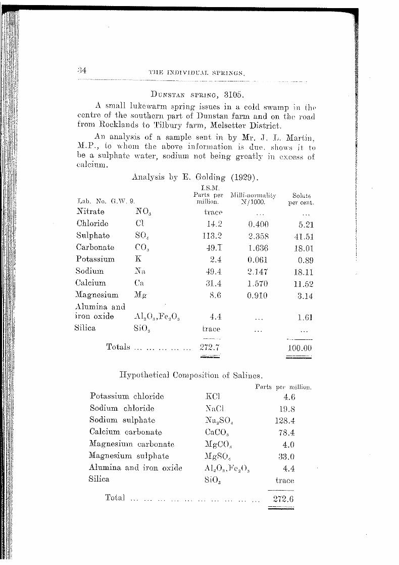
DUNSTAN Sl'InNG, 3105.
A sn1all lukewarm spring issues in a cold swamp in th" centre of the southern part of Dunstan farm and on the road from Rocklamls to Tilbury farm, Melsetter District.
An analysis of a sample sent in by Mr . .T . .L. Martin, .Yl.l'., to whom the above information is due. slw"·s it to be a sulphate water, sodium not being gTeatly in clxcess of calcium.
Analysis by K Golding ( 1929).
Lab. No. G.V\7. 9.
Nitrate
Chloride
Sulphate
Carbonate
.Potassium
Sodium
N03
Cl
so, C(\ K
:i'n Calcium Cn
.:\fagnesium J\fg-
Alumina and iron oxide Al0 0 3 ,1<'e"O' Silica SiO,
'rotals ..... .
I. S.M. Parts per ~'Iilli-normalitY Solute)
mi!lion. N/1000. · per cent...
tracP
1+.2
113.2
4!l.T
2.4
4!l.4
a1.4 S.G
4.4
trace
272 .. 7
0.400
2.a;sR I. GaG O.OGl
2.147
1.570
O.!llO
5.21
41.51
18.01
0.8!l
18.11
11.52
3.14
l.Gl
100.00
Hypothetical Composition of Salines.
Potassium chloride
Sodium chloride
Sodium sulphate
Calcium carbonate
Magnesium carbonate
Magnesium sulphate
Alumina and iron oxide Silica
Total ...
KCl
NaCi
Na,SO,
CaCO,
.:\fgCO, llfgSO, Al,C\,Fe,(\
SiOz
Pal'ts per milliou.
4.G lD.8
128.4
78.4
4.0 ;{3.0
4.4
trace
272.G

THE E\ll!VIJHJAL SPRINGS.
ELEPHANT SPRING. See S1:gobomo sprinp, 4209. Gono sPRINGS, 4201.
'l'he position of this group is plotted on tho geologica] map accompanying the Southern Rhodesia Geolog·ical Sur· vey Bulletin No. 4. It is situated about eight miles southwest of Del;:a siding on the J3ulawayo-Victoria Falls railway line, Wankie District, and the altitude is about 2,500 feet.
The water is brackish to the taste, smells slightly of sulphuretted hydrogen and has a somewhat milky appearance. The natives do not consider the waters potable, and claim that they act as a purgative. Animals, however, drink the water.
Analysis by E. Golding (1928), of a sample collected hy B. Lightfoot.
I. S.M. Parts per 1\Iilli·normality Solute
Lab No. \V.A. 4.
Nitrate Chloride Sulphate Carbonate Potassium Sodium Calcium Magnesium Alumina and iron oxide Silica
million. N jlOOO. per cent.
NO" slight trace Cl 1285.1 36.200 so. 229.3 4.777 co3 282.7 9.423 K 33.5 0.859 Na 978.7 42.552 Ca 91.5 4.575 Mg· 29.6 2.446
Al20, Fe2 0 3 6.2 Si02 24.0
'rota Is 2960.6
Hypothetical Composition of Sa liD es.
43.41 7.74 9.55 1.13
33.oti 3.09 1.00
0.21 0.81
100.00
Parts per millio11. Potassium chloride Sodium chloride Sodium sulphate Sodium carbonate Calcium carbonnte Jlfagnesium carbonate Ali.unina and iron oxide Silica
Total
KCI NaCl Na,SO,, Na,CO, CaCO, J\IIgCO, Al,O,F<'2 0, SiOz
64.0 2067.6
339.1 128.8 228.4 102.5
6.2 24.0
2960.6
'J'HE INDIVIDUAL SPRINGS. -- -------------
The water is a weak brine with small amounts of carbonate and sulphate, sodium being the dominant kation.
The group consists of a number of springs localecl alongthe line of the Gobo river fa11lt which trends in a nortJi-east to south-west direction through the Escarpment Grits of the Karroo system.
Refe1'ence. Lightfoot, B. The Geology of the 1\ortllWestern Part of the vVankie Coalfidcl. Soltthel'n Rhodesia Ueological Su1Tey B1tllettn !V o. 4, pp. :21 ,md 44, Bulawayo, 1914.
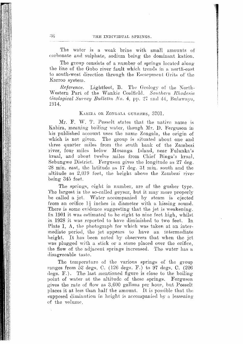
JCUJIIlA OR Zo:s-GALA GUSlilms, 3701.
Mr. F. vV. 'l'. I'ossclt states that the native name 1s
Kabira, meanjng boiling water, though lllr. D. Ferguson m his published aeeount uses the name Zongala, tho origin of which is not given. 'l'hcl gToup is situated about one and three quarter miles from the south bank of the Zambezi river, four miles below lliosanga Island, near Fulunka's kraal, and about twelve miles from Chief Binga's kraal, Sebungwe District. :Ferguson gives the longitude as 27 deg. 28 min. east, the latitude ns 17 deg. ;n min. south and the <tltitude as 2,0.1 9 feet, the height above the Znmbe%i river being 345 feet.
The springs, eight in number, are of the gusher type. 'I'he largest is the so-ealled geyser, but it may more properly he called a jet. \Vater accompanied by stoam is ejected from an orifice 1,\ inches in diameter with a hissing sound. 'l'here is some evidence suggesting that the jet is weakening. J:n 1901 it was estimated to be eight to nine feet high, whilst in 1928 it was reported to have diminished to two feet. In Plate I, A, the photograph for which was taken at an intermediate period, the jet appears to have au intermediate height. It has been noted by observers that when the jet was plugged with a stick or a stone placed over tho orifice, the flow of the adjacent springs increased. Tl10 water has a clisagreeahle taste.
The temperature of tlH' various springs of tlw group ranges from [)2 degs. C. (12G degs. F.) to 97 degs. C. (20G <legs. F.). 'l'he last mentioned figure is close to the boiling point of water at the altitude of these springs. Ferguson g-ives the rate of flow as a,GOO gallons per hour, but Posselt places it at less than half the amount. It is posoihle that t.lw supposed diminution in height is accmupanied l>y n lessening· of the volume.
EAillRA OR ZONGALA GUSHERS.
Analysis by D. FBrguson (1902).
Calcium carbonate Potassium chloride Sodium chloride Silica
Total
OaCO, KCl NaCl SiO,
0.00210 0.04117 0.0129:3 0.00600
0.06220
'l'he table belo\\' ~hows the analysis re-caleula ted in iono. 'l'he composition of the water is shown in parts per mi.llion, and is followed by the milli-normality and by the percentage composition of the solute.
I.S.lVL Parts per 1'lilli-normality Solute million. N flOOD. per cent.
Chloride Ol 274.2 7.72 44.0R
Carbonate co, 12.6 0.42 2.0:-; llotassium K 215.9 -- r.. <_) u.()u a4.70
Sodium Na 50.D 2-.21 8.20
Calcium Ca 8.4 0.42 U1G Silica ::ro 1 2 60.0 9.64
---~- ----'l'otals 622.0 100.00
-------- ----- ~---
Sulphurctted hydrogen is given o:ff by tho wnt<')rs, and around the springs are deposits .of silic13ous and some calcareous sinter.
The spring·s are situated along the foot of a range of hills formed of sandstones, grits and conglomerates of the Karroo system, no volcanic rocks being seen anywhere near them. 'l'hn rocks are stated to be tilted up in long .5tep-like ridg·es.
Refer·ences. Ferguson, D. The Ge:yseTs or Hot SpringE of the Zambesi and Kafue Valleys. Proceedings Rhodes1u. Scientific llssociat1:on, Vol III, pp. 11-13, 1902.
Unpublished communications from J\fr. .F. vV. T. Posselt received lOth November, 1916, Rnd from Lt. Col. Carbutt dated :lrd :February, HJ30.
11incll, Professor l\l. l\1. 'l'he Medicinal Springs of Soutb Africa. So11th ,1frican J rncrrw.l of Scr·ence, Yol. XIII, p. 53R, Hll7.

38 TilE JXlJ!VlllUAL SPRINGS.
KABWILI OOZE, 4409.
'l'he ooze is located in Nor-thern Rhodesia, about 18 mile,.; south-west of the confluence of the Kafue river and about 10 miles west of the left bank of the Zambezi river.
'rhe waters contain salt. The temperature when record,,d was 21 degs. C. (70 dogs. 1<'.).
'l'he waters are believed to come to the surface through rocks of Karroo age.
Hefepence. Information from Mr. C. F. :lfolyneux dated lGth May, 1919, and lith April, 1929.
K.~LISHE SWAMP, 2G03 (KARUSHU iHLT PAN).
A reedy green swamp with patches of open water lies about three hundred yards cast of the lliiami-Chirundu aerodrome road three and a half miles before reaching the banks of the Zambezi river. This spot is 19~ miles beyond tlw road drift on the N yamasanga river and at the south-eastern corner of the spurs from Chirundu hill, Lomaguudi District. 'l'he 1932 survey for the Sinoia-Kafue railway route passes just to the east of it.
It is sometimes known as the Kirushu. or Karusha salt pan, but it appears to be n pr1rmanent swamp into which a sulphate water oozes without visible flow. H measm'CS about 125 yards across from north to south. From west to cast it is somewhat longer, and seepag-e from it takes place to the east, in which direction there are said to be other oozes or spring-s. Ka.lishe is the name the natives give to the local efflorescences of salt, and it suggests a Portuguese origin. A slight efflorescence of a white, hitter salt is noticeablP on the lumps of black soil in the swamp.
Kalishe swamp is about 100 feet above the Zambezi river, that is, it lies at an altitude of abm.\t 1,350 feet. above sea level. A gravel containing- well-rolled pebbles up to two inches long appears through the soil between it and the road, and it may represent an old terrace of the Zambezi river. A number of the pebbles have been broken and fashione'l into implements by middle stone ag-e man. The undmlying formation, as seen by outcrops in the neig-hbourhood, consists of Chirundu sandstones and grits which probably belong to the Escarpment Grits (lJpper Karroo).
'The following· figur!JS are re-calculated from those of an analysis made by Geo. A. Pingstone, The Bulawayo Assa0' Office and Public Laboratory, R.eport No. 190(), 20th December, 1930.

EALJSJU' S\\";Ull' (KARL'SllU SALT 1',\")-
Labelled water sample No. 35 from Karushu salt pan.
Xitr·ate Chlori(le Sulphate Carbonate Sodium Calcium Magnesium Alumina and iron oxide Silica Suspended matter
Parts per million.
NO, 1.5 c1 m9.1 SO, 100f>.1 CC\ 83.9 .Na G67.1 Ca 75.1 ~Ig trace
Al2 0,:Fe,O, trace c• ·o '") () l-Jl '2 ()_ ......
trace
'l'otal ... 2233.8
Milli-normality N /lOCO.
0.02 8.99
20.94 2.80
29.00 3.76
Percentage composition
of solute.
0.06 14.29 45.00
3.76 29.8G
3.3G
3.67
100.00
Hypothetical Composition of Salines.
Sodium nitrate Sodium chloride Sodium sulphate Sodium cluhonatc Calcium sulphate Magnesium sulphate Silica
Total
?\a::\(\ ::\' aGl Na,SO, Xa,CO" CaS OJ MgSO, SiO,
Organic Analysis.
}'ree nn1m0111a Albuminoid ammm1ia Xitrogon as nitrates Chlorine
Parts per million.
2.0 526.1
1220.4 148.3 255.0 trace 82.0
2233.8
Parts per million.
0.90 0.40 0.38
:n9.5o
'l'hn \ntter forming the ahone sample was reported a., slightly opale.sc<'ll t \\·.i U1 u yellow tint, slight ocrlimen t, no smell, alkaline> reaction. It was also pointed out that the water was org-anically impure. At the time of the author's visit tho water had not reeently been disturbed by animals. It was bright aml clear, and not unpleasant to tho taste.
A nahn> stated that there were several salt crusts "fanika lo J<:psom-salt" in the neighbouring r:ountry. ThP

THE INDIVIJJU AL SPRINGS.
probability is that they are really Glauber's salt like tlw efflorescence from the :M:endayatswa ooze and the om· quoted below.
Analysis by E. Golding of surface salt deposit from Kalishe swamp.
Specimen received from J. E. S . .Tcffares, Esq., SinoiaKafue Railway Survey: November, 19ill.
Analysis of the salt gave the following results:-
Nitrate Chloride Sulphate Carbonate Bicarbonate Sodium Potassium Calcium Magnesium Alumina and rron oxide Silica :Moisture at 110 degrees C.
Total
NO, Cl so, co, HCO" Na K Ca Mg Al 2 0,,Fe,03
SiOz H 2 0
Probable Composition of Salines.
Per cent.
nil 2.84
61.65 0.27 us
31.3G nil
0.50 0.07
trace 0.67 1.14
99.88
Sodium chloride NaCl 4.6G Sodium carbonate Na2 CO., 0.48 Sodium bicarbonate N aHCO, 1.90 Sodium sulphate Na2 S04 88.97 Calcium sulphate CaS04 1. 70 Magnesium sulphate MgSO., O.ilG
It is stated that a small spring bubbles up on the eastern flank of Chirundu hill about half wa.y between Kalishe swamp a.nd the Zambezi river bank. The stream from it forms some pools, but does not reach the road. An efflorescence of white salt occurs below the eye, but whether it is also mainly sodi1un sulphate (Glauber's salt) or not is not known.
KAPESA (OR CHATENTA) THERMAL SPRINGS, 4405. The gToup is located in Northern Rhodesia ftbout n
miles north from the Zambezi river, and 4Q miles upstream from the Sanyati river confluence close to a proposed route of the Sinoia-Kafue railway. 'rho altitude is about 1,450 feet.

LUllHIHI THmDiAL Sl'IU:NGS. 4! ·---------- ........ -----
A number of salt ooze~, from which the natives extract salt, occur in a valley two miles across. At the bead of the valley between basalt hills arc a number of hot sprmgs issuing over a leng·th of fifty yards.
The temperature of the water when l'Oco.rcled was 73 degs. 0. (172 degs. :F.), and it is said to he constant. 'l'he water is stated to smell of sulphur, and a siliceous deposit is associated with the springs. The rate of flow does not vary, and it is estimated that the overflow would fill a three inch pipe.
As sediments of Karroo age are known to occur both north and south of this locality, the basalt refmred to above is no doubt a lava of the Upper Karroo (Stormberg age) overlying· the sediments.
Refe?·ences. Information from J\lr. G. R. Holgate dated 2nd October, 1916, and from Mr. C. ]'. Molyneux dated lGth :Ylay, 1919.
Rincll, Professor :M. M. The Medicinal Springs of South Africa. South AfTican J ou1·nal of Science, Vol. XIII, ]_). 543, 1917.
LUBIMBI THEIUfAL SPIUNG, 3702. The Lubimbi thermal spring is located in the Luhimhi
salt swamp which extends from tlw north bank of the Shangani river to the foot of some sandstone kopjes about three miles from the river. The swamp is situated about six miles east of Shangani drift OT\ the Walker's Drift road, and in the south-western corner of the Scbungwe District. The altitude is probably between 2,500 and :l,OOO feet.
'l'he rock formation in the area is a sedimentary seri('S uf the Karroo system.
The spring is stated to be very hot. 'l'he i1ow is considerable, being estimated at 2 to 4 cnsees hy Dr. E. A. N obbs, who collected the sample, the analysis of which is quoted below.
'l'lH" water smells of sulphuretted hydrogen and is slightly turbid. 'l'itration of a portion of a sample (Lab. No. 147 G) received at the Agricultural Chemical .Laboratory in a quart bottle with a cork stopper in .July, 1920, with centinormal iodine solution gave the sulphuretted hydrogen content of the water as 24.0 parts per 1nillion. After suction through a Berkefeld filter, the sulphuretted hydroge11 was removed, hut the ''"ater gave an alkaline reaction ,,-ith litmus.
42 TilE Jl\1llV1Dl7AL SPRINGS.
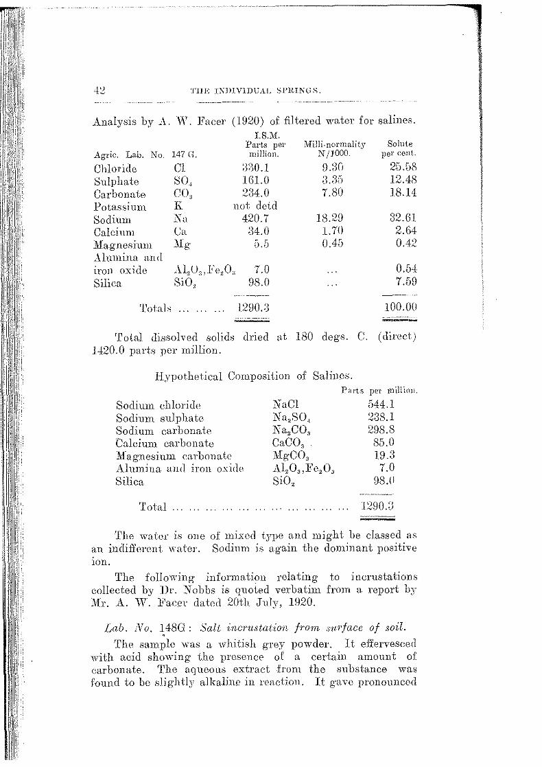
Analysis by A. IV. J<'acer (1920) of filtered water for salines.
Agric. Lab. No. 147 G.
Chloride Cl Sulphate SO, Carbonate CO, Potassium K Sodium Sa Calcium Ca Magnesium Mg Alumina an <l
I.S.JVI. Parts per rnillion.
3:30.1 HH.O 234.0
not detd 420.7
;14. 0
iron oxide Silica
Al,O, Fe,O, 7.0 SiO, 98.0
Total., ..... . 1290.:)
MilJi.normality N /1000.
9.~3CJ
7.80
18.29 l. 70 0.4G
Solute per cent..
25.58 12.48 18.14
32.61 2.64 0.42
0.54 7.59
100.00
Total dissolved solids dried t<t 180 degs. C. (direct) 1420.0 parts per million.
Hypothetical Composition of Salillos.
Sodium chloride Sodium sulphate Sodium carbonate Calcium carbonate J\fagnesium carbonate Alumina and iron oxi<le Silica
'foial
NaCl Ka 2 SO, Na,C03
CaC03
.MgC03
Al2 0,:B'e2 0 3
Si02
Part.s per million.
544.1 238.1 298.8 85.0 I9.a 7.0
98.(1
The water is one of mixed type and might he classed as an indifferent water. Sodium is again the dominant positive lOll.
The following information relating to incrustations collected by Dr. Nohbs is quoted verbatim from a report by 1l£r. A. W. Facer dated 20th ,July, 1920.
Lab. No. ~ 48G : Salt ·inc1'ustat·ion from su.1'face of soil.
The sample was a whitish grey powder. It effervesced ·with acid showing the presence of a certain amount of carbonate. 'J'he aqueous extraet .from the substance was found to be slightly alkaline in reaction. It gave pronounced

LUJlL\!BI Tl!EH?>IAL ~Pl\1::\l:.
reactions for chloride and sulphate, but contained no nitrate. It was found to contain a trace of"limc and magnesia. The :flame test showed sodium very prominent, with a trace of potassium.
From this it is evident that the carbonate, ehlorille and sulphate are almost entirely combined with ~odium.
The water soluble constituents of tho substance were quantitatively determinfld as follows: -
50 g·ms. of the sample which has lwen passed through a 1 mm. sieve "·ere shaken for two days with about 800 c.c. of water, then filtered and made up to 1,000 c.c.
Determinations of total solid and saline constituents were then made upon this extract, yielding results as follow:-
Portion of substance soluble in watcr-1;l.74 per cent (dried at 180 degs. C.).
The composition of the water-soluble portion was found to b!'l as follo"-s :---
(Amount of sodium salts found by coomhining· the amounts of acid radieks determined by analysis with the quantities of sorlium founll hy calc11lation to satisf:y them.)
FMcentage Composit:zon: H'ater-solnule solids, dried at 180 degs. C. (1:3.74 z)(or cent; of ong·inal suustance).
I~oss on ignition Sodium carbonate Sodimn chloride Sodium sulphate
Total
Na,CO, NaCl Na,SO.,
Per c,EmL.
1.05 l.SC! 9.02
81.74
93.64
l'ortion 1mnecounted for (Ca, Jiig and K :salts) 6.3G
fAll! . .Vo. I:l9G: Salt .hmn e,ye of spring.
'l'his consisted of whitish grey thiek flakes. It effervesced with acid showing 1 ho prescmee of carbonate. The aqueous extraet was found to lw decidedly alkaline' in reaction. Qualitative analysis shtnvc;d it to contain chloride and sulphate but no nitrate. Examination for metals gave only very .slight traces of calcium and magnesium, and it was therefore presumed tliat tho aeicl radides were nearly entirely combined with sodium; which was prccdominant. in the flame test (by which no potassium could he o hservcd).

THE INDIVIDUAL SPRINGS,
Estimation of the water soluble solids hy the same method as for 148 G gave:-
Portion of substance soluble in water----66.29 per cent (dried at 180 degs. C.).
The composition of the water soluble portion (determined as in the case of 148 G) was found to he as follows:--
l~e1'centage Composition: ·w ate1'-soltlble solids, dr1:ed at ISO degs. C. (66.29 pe1' cent of O?'ig·inal substance).
I~oss on ignition
Sodium carbonate Sodium chloride
Sodium sulphate
Na2CO,
NaCl
Na,S0 1
'l'otal solids aceounted for __ _
J\{ANZAIA THERMAL SPRING, 4404.
Per cent.
0.5
2.59
41.37
54.7
99.16
The spring is located in Northern Rhodesia, l i miles from the left bank of th,, Zamhezi river, about 50 miles westsouth-west of the Sanyati confiuenee, and about 10 miles downstream from the eonfiuence of the Seng·wa. river.
The temperature recorded was 66 degs. C. (150 degs. F.). No vegetation grows in the immediate vicinity of the spring, and there is no salt deposit.
The geological formation of the area in which the spring is located is believed to be a sedimentary series of sandstones, grits and shales of Karroo age, hut basalt is Teported to occur a mile away.
Rejet·ence. Information from Mr. C. F. J\folyneux dated 16th May, 1919, and 11th April, 1929.
MENDAYATSWA OOZE, 2602.
Tl1is ooze is situated about five feet below the normal flood terrace of the Zamhezi river and on its right bank al the western foot of Chirundu hill, Lomagundi District. It is reached by a rough track (1.8 miles long) leaving the Miami-Chirunrdu aerodromo road to the left (south-west) 0.6 milo heforo reaching the terminus of the road on the river hank. 'l'he altitude is probably about ] ,270 feet above sea ]eYe!.

~:I]~NDAY:\'l'S\VA OOZl~.
The ooze consists of a sixteen yard length of hot, black nmd under a layer of sand on the edge of a pool in a branch of the Zambezi river only in use when the river is in flood. The mud is uncomfortably hot (about 50 degs. C.) five inches .below the surface, hut the water of the pool is only tepid to warm. There is no visible flow from it, bubbles are scarce, but a slight smell of s11lphur is noticeable at times. The sand around the pool is speckled with a light efflorescence of white salt, which consists essentially of sodium sulphate (Glauber's salt) as the analysis below shows.. A similar salt comes from the Kalishe swamp 2603 on the other side of Chirundu hill.
Analysis by E. Golding (1933) of efflorescence at the Mendayatswa ooze collected by H. B. :Maufc, 22nd
August, 1932.
Lab. No. G.W. 20.
NO,
Cl
CO,
SO.,
Na
K
Ca
:n£g
Per cent.
trace
1.16
1.15
52.06
24.21
0.46
1.16
0.40
Al2 0,,Fe2 0 3 1.20
Si02 18.08
99.88
KCl
NaCl
CaSO,
CaCO,
MgSO,
S '() l '- 2
Per cent.
0.88
1.22
73.2g
1.32
1.98
1.20
18.08
99.88
Recalculated to pure salts.
Per cent.
1.09
1.51
90.92
1.64
2.38
2.46
100.00
'1\vo ·winchester quart bottles of the water were received from Mr. L. McAdams, Native Commissioner, in 1931. M.r. Golding reports that the water was turbid and contained a sandy sediment. No smell of sulplnu' could be detected on arrival at the laboratory.

-1 (j TilE 11\"JJlYIDt:AL Sl'Rl.?lGS.
Analysis by E. Golding (1931). I. S.M.
Parts per :Milli-normality Solute Lab. No. G.W. 18. million. N /1000. per cent.
Nitrate NO, nil Chloride 0! 200.2 5.64 12.65 Sulphate so, 743.2 .1 5.57 47.26 Carbonate co, 42.0 1.40 2.65 Potassium K 7" .~ 0.18 0.45 Sodium Na 425.3 18.49 2G.87 Calcium Ca 72.0 3.GO 4.55 Magnesium Mg 4.2 0.35 0.27 Alumina and iron oxide Al,O,Fe,O, 4.0 0.25 Silica SiO, 80.0 5.05
Totals . . . ... 1583.1 100.00
Hypothetical Composition of Salines. Parts per million.
Potassium chlor-ide Sodium chloride Sodium sulphate Calcium carbonate Calcium sulphate Magnesium carbonate Alumina and iron oxide Silica
Total
KOI NaCl Na,SO., CaCO, CaSO., MgC03
Al20,:Fe,03
SiO,
13.8 319.2 925.G 53.0
173.3 14.2
4.0 80.0
1583.1
A weak chloridc-:;ulpha tc \nl tor "·i th sodium as the dominant kation.
Chirundu hill consists of bu:ff and red mottled sandstones and grits, the latter containing scattered white quartz pebbles in places, thus resembling the Escarpme11t Grits of rhe Karroo system. 'l'be outcrops at the foot of the hill near the Mendayatswa ooze are quartzites, evidently the sandstones silicified. 'l'hey appear to bo dipping at an angle of :Jo degrees to the west, that is, ·towards tlw omm and the Zambezi river. This unusually high dip suggests the pre'ence of a fault, which may be trending in a south-easterly direction parallel to the extension of the oo,e.

~J\\'ESCmZT (WESGESl) TllEJUlAL i>l'RIKG. 47
Reference. Information and speeimen of water from JYlr. L. McAdams, Assistant Native ConHnissicmer, 1980.
Observations by the author, 1932.
"}iFLDIJHJL\. See "The Hot Sp;·inps,'' :3102.
MwEKGEZI ('Wm;-cmsr) TIIEIUIAL sPmKG, ;3101. 1'he spring· is located on crown-land north of tlw
Umvumvuvu river, which was transferred in 1929 from tlw Umtali District to the Mdsetter District. 'l'he eye is 200 yards from the left hank of the Odzi river and 70 feet above it. It is approached by means of a track half a mile long· leaving the old Umtali-Chipinga road one mile north of tlw lowest drift through the Umvumvuvu river. Munundega's kraal is close by. 'l'he altitude is 2,050 feet above sea level.
The spring issues into a pool four feet by two feet, through which a gas smelling slightly of sulphuretted hydrogen bubbles spasmodically. A very small stream runs from the pool to the Odzi river. 1'he temperature of the water at the eye is 53 degrees centigrade and is just beam ble by the hand.
Analysis b:v A. G. Holborrow, Government Chemist (l.HJGI. Agric. Lab. No. 1702.
Sodinm chloride
Sodium bicarbonate Sodium sulphate
Calcium carbonate 11ag·nes_i nn1 caJ.'bonaJc
A:lumina and iron oxi<l<'
Silica
Total
l'otash salts and organic
'rota! solids at 105 Loss on ignition
Parts per million_
NaCl
NaHCO" Na2 SO,
CaCO, MgCO,
Al,O,l<'e,O, " SiO,
54.7 176.0
47.6 8.6
5.0
7.8 53.6
a53.3
matter not determined.
dcgs. C. a6'l 58
'l'he table below shows the analvsis re-calculated m wns. The composition of the water is sh;wn in parts per million, and is followed by the milli-normality and JWlTentage composition of the wluic•.

'l'IIE INJllVIDU AI, SPltiNGS.
Chloride Cl Sulphate 801 Bicarbona to HCO, Carbonate CO, Sodium Na Calcium Ca ..\Iagnesium Mg _,\.lumina and. Iron oxide Al 20,Fe2 0s Silica Si02
Totn]:; ...
I. S.M. Parts per million.
33.2 32.2
127.8 8.8
85.1 3.4 1.4
7.8 53.6
<)·~ q q 000.0
lVIilli-normality N/1000.
0.93 0.67 2.09 0.29 3.70 0.17 0.11
Solute per cent.
9.40 9.11
3G.17 2.49
24.09 0.96 0.40
2.21 15.17
100.00
Tho water is a weak carbonate one having sodium for tho principal metallic base or positive ion. It is of course also a weak alkaline watcr.
Although grey granite crops out along the line of the wain road a red, highly felspathic g-ranite takes its place a short distance west of the road, and crops out again on the banks of the Odzi rive1· immediately wost of the spring. The red granite is he1·e much shattered and is traversed by veinlets of quartz. It is probably dose to the line of the Sabi fault or <1 branch of it. 'Ihe I\futambara (3102) and ltupisi thermal springs (:H03) are also weak carbonate ;mters, and the former is very definitely associated with the Sabi fault.
Reference. Observations by the author.
NAJ,UYU SPRINGS, 4408. 'l'he group is located in Northern Rhodesia on the left
hank of the Zamhezi river about 58 miles south-west of the Sanyati confluence.
'l'he waters contain salt. The temperatme of the hottest spring at tho time tho observations were made was :)2 dogs. C. (90 d(.)gs. ]'.). The springs drain into the /:ambezi river.
'l'he geological formation of the anm in which the group oecurs is a sedimentary series of sandstones, grits and shales of Karroo age.
Reference. Information from Mr. C. F. Molyneux, lGth }fay, 1919, and 11th April, 1929.
NTCIIENGE lllUN>; S.Plt!NGS. 4H
NICHENGE BRINE SPRINGS, 4204.
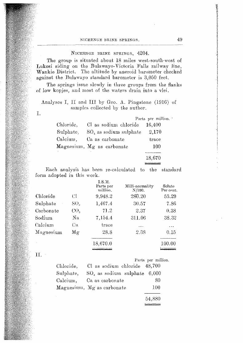
'l'he gro1.1p is situated about 18 miles west-south-west of I,ukosi siding on th0 Bulawayo-Victoria Falls railway line, Wankie District. 'l'he altitude by aneroid barometer checked against the Bulawayo standard barometer is 3,050 feet.
'l'he springs issue slowly in three gToups from the flanks of low kopjes, and most of the wat0rs drain into a vlei.
Analyses I, II an,] III by Goo. A. Pingstone (1916) of samples collected by the author.
I.
Chloride,
Sulphate,
Calcium,
Parts per million. ·
Cl as sodium ehloride 16,400
80.1 as sodium sulphate 2,170
Ca as carbonate trace
Magnesium, Mg as carbonate 100
18,670
Each analysis has been re-calculated to the standard form adopted in this work.
Chloride Cl
Sulphate sol Carbonate C(\ Sodium Na Calcium Ca :.Magnesium Mg
II.
Chloride,
Sulphate,
Calcium,
I. S.M. Parts per Milli-normality Solute
million. N/100. Per CPnt.
9,948.2 28tU?O 53.29 1,467.4 30.57 7.8G
71.2 2.37 0.38 7,154.4 3ll.OG 38.32
traee
28.8 2.:38 0.15 ---
18,670.0 100.00 ----·--·~---
Parts per million.
Cl as sodium chloride 48,700
SO., as sodium sulphate G,OOO Ca as carbonate 80
Magnesium, Mg a.~ carbonate 100
54,880

50
Chloride Sulphate Carbonate Sodium Calcium Magnesium
III.
Tlnl INDIVIDUAL SPRINGS. ,,,_,_,, ___ _
Cl SO,, COs Na Ca Mg
I. S.M. Parts per million.
29,541.4 4,057.2
119.2 21,101.4
32.0 28.8
54,880.0
l\Ii IIi-normality N /1000.
832.15 84.62
3.97 917.45
l.GU 2.38
Solute per cent..
· Ga.ss 7.:1B 0.~'2.
38.4:i 0.06 0.05
100.00
Parts per million.
Chloride, Cl as sodium chloride 23,000 Sulphate, SO, as sodium sulphate 4,600 Calcium, Ca as carbonate 190 Magnesium, :N[g as carbonate trace
27,790
LS.M. Parts per Milli-normality Solute million. N/1000. per cent.
Chloride Cl 13,951.8 393.01 50.21 Sulphate SO,, 3,110.5 64.80 ll.l!J
Carbonate co, 113.9 3.79 0.41 Sodium Na 10,537.7 458.1G 37.92 Calcium Ca 76.1 3.81 0 ')~ •Nj
Magnesium Mo· b
trace -·--
27,790.0 100.00
I. Sample from shaft sunk in vlei, brine standing about 10 feet below surface.
II. Sample from small excavation below the most easterly of the south-westerly group of springs.
III. Sample from shaft below the most westerly of the northern group of springs.
'l'he water is a weak brine with some sulphate, sodium being the dominant kation. It is, however, a noticeably stronger brine than the water taken direct from the thermal spring, and doubtless indicates that the solution has beell strengthened by natural evaporation.

NICH~]NGE BRINE SPRINGS. 51
These springs are the only ones at which an attempt has been made to extract the salt on a commercial scale. 'l'hey were first pegged in 1907 as the Usanga claims under Pt. Y (J£ the mining law by A. \Virth and .F. A. N orvall. Some shallow shafts were sunk and a stone-lined evaporating pan constructed. The analyses were made on samples taken from these shafts. 'rhey were re-peg·ged in 1921 by Mr. J. Hepker as the Lukosi claims, and som.e more shallow shafts sunk, but the claims went to forfeiture in the following year.
In 1932 the site of the springs was again pegg·ecl, this time by Mr. H. R. Cumming as the Sinementala claims, and experiments are being conducted both by solar evaporation in different kinds of pans and by fire heating with the object of producing a commercial salt.
Analysis by E. Golding (1932) of salt obtained by evaporating a composite sample of brine.
Lab. No G.W. 6A. Per cent.
Nitrate Chloride Sulphate Carbonate Sodium Potassium Calcium Magnesium Alumina and non oxide Silica
N03
Cl SO., co 3
Na K Oa Mg Al2 0,:Fez0" Si02
'rotal . . . . . . . . . . .. . .....
Composition of the Salt.
l'otassium ehloride So eli um ehloricle Sodium sulphate Calcium sulphate :Magnesium sulphate Alumina and iron oxi(le Silica
KCl NaCl Na.2 S0 .. 1
OaSO, MgSO, Al2 0,1<'e20, Si02
'rotnl . . . . . . . .. . . . . .....
nil 52.83 8.24
trace 35.31 1.85 0.96 0.37 0.16 0.28
100.00
Per cent..
3.53 84.32 6.62 3.26 1.83 0.16 0.28
100.00

TilE INDIVIDUAL SPRINGS. ------·---~-----. ~----- - ---------- ------ ---------·--
Mr. Golding· remarks: "It will be seen that the total chlorides amount to 87.85 per cent of the salt obtained, the remaining 12.15 per eent being impurities. 'l'he impuritie' in the salt are represented by sulphate, osides of iron and a.lumininm, a.!Hl siliea. 'l'hese impurities are not serious alld nould he eliminated in praetiee, if the evaporation is JJrJt
allowed to proceed too far.''
This salt was obtained from a sample of brim' from the Sinementala claims sent in by 'Mr. H. R. Cumming-. The brine was analysed in the Geological Survey Laboratory ancl the result quoted below confirms the figures of t.lw previom; analyses by Mr. G. A. Pingstone.
Analysis by E. Golcling (Hla2) of a sample sent m by IT. R. Cumming·.
r.s.~r. Parts per J\Ii lli-norm a.] i ty Solute
Lab. No. G.W. 6. million. N jlOOO. per cent.
N it.rate NO,. nil nil nil
Chloride Cl 1') 459 0 ...... , . io.), il50.7G 52.51
Sulphate so, l,Silil.O il8.Hl 7.7:1
Carbonate co,, nil
Bicarbonate nco3 2G9.5 4.42 1.14
Sodium Na 8,757.0 il80.74 ~:HJ.9:~
Potassium K 88.0 2.2G O.il7
Calcium Ca. 177.0 8.85 0.74
:Magnesium M:g 77.0 G.an o.:12
Alumina and iron oxide Al/l,.,l<'e20 3 24.0 O.W
Silica SiO, il5.2 O.Hi
'fotals ... ... 23,712.7 100.00 ~-~~~--· --
Total solids in HO!ut.ion are 2il, nw parts per million dried at 100 clegs. centigrade or 0.2:l7lh per gallon.
The sample when received had a clistinet odour of sulphuretted hydrogen, which was found to he present to the extent of 7.6 parts per million.
l I l
I ·i

I'\TC'Ill~SGE HRJNE SPlllNG~.
Hypothetical Composii.ion of Snlines.
I. S.M. Parts r·f>l'
mdlioi-J.
Potassium chlcn·id,, KC! 168.0
Sodium chlorid<' XaCl :Z.O,;lD/.0
Sodium sulplnin Nn,SO, 2,2Gl.ll
Magnesium sulphate 1Ii!;SO, ;!SI.O
Calcium hicarbonnte Cn(1ICO,), J4().~)
Alumina and iron oxide :ZJ.(J
Silica SiO, 36.2
'l'otals 2{),712.7
Graills per gallon.
11./(i
] ,J:Z/.1'!1
LJ8.2./
'W.C!7
:n .:zc
1.68
2.4G
1, 639. S!l
Mr. II. R. Cumming sin.tes that Uw "·ater of one of this group of springs is pleasantly warm on a colrl morning. 'l'bis thermal eye is not n v0ry strong one, but its JH'P.sence is of considerable interest, as it i 11 <licates that i be group is not essentially different from other mineral springs in the district. 1'here is an idea tha.l the brine in these springs comes from water belouging to the ordinary underground circulation percolating through a bed of rock salt rwd di.,;solving some of it. Thore is, however, no cYi<lonco in the local Kun.·ou nwk.-; to lead oue to think that a deposit of l'Ol'k stdt might l1c•
included in them. 'l'hat these springs are really normal thermal springs is also indicated by tho character of tlle water from the thornml eye. A sample of ihi.s was sent :in by Mr. Cunnuiug aml analysecl in the Geological S1ITVe.1·
Labor~.tory. The figures quoted lwlow show that the water is a ·weak brine with a little .sulphate and bicarbonate, and that it does not differ in any ossent.ial respect from il1e neigllboiJ.ring Gobo 4,201 ancl Ghawuto 420:1 sprmg.-;,
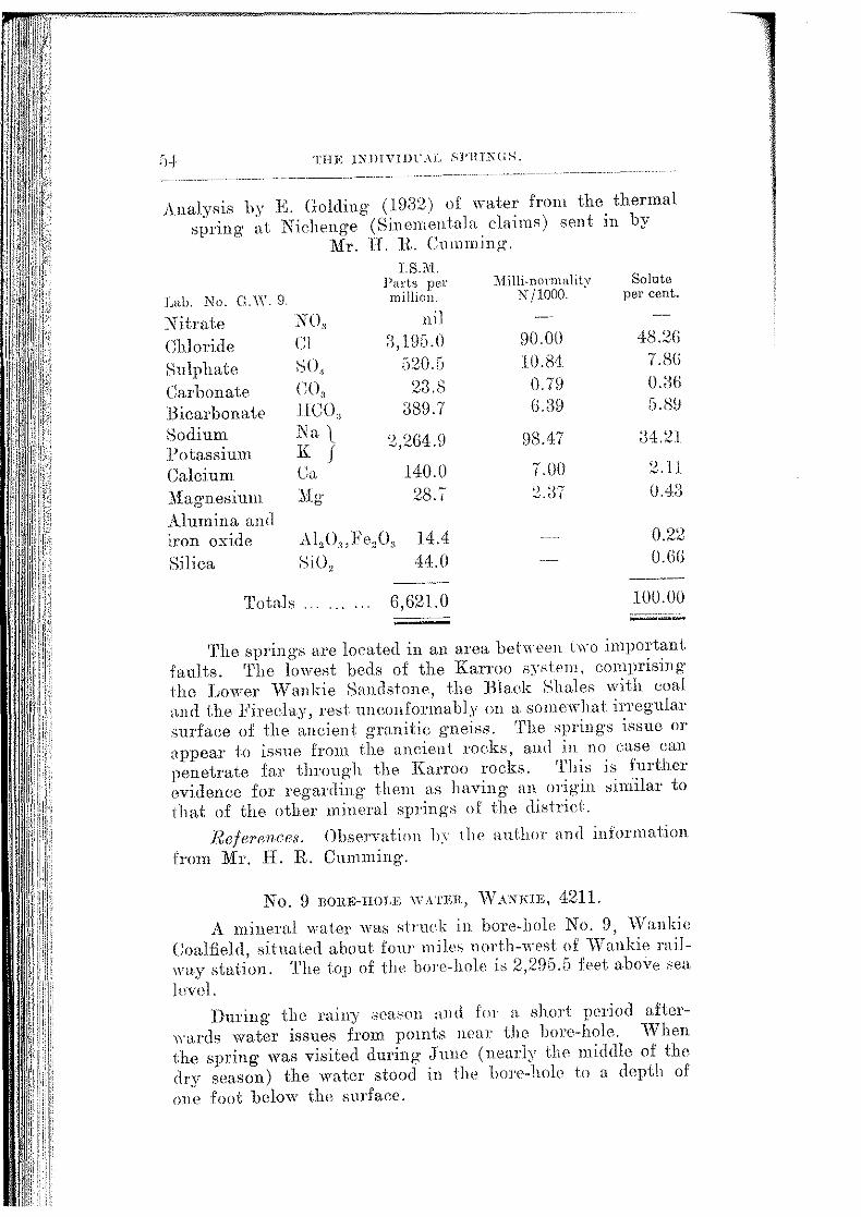
THE 1:\IHVIIlL\L .~l'HT:SUS.
Analysis by K Golding (19:32) of water from the thermal spring· at Nichenge (Sinement.ala elaims) sent in by
.. Mr. II. IL Cmnrning.
Lab. No. G.W. 9.
Nitrate Chloride Sulphate Carbonate .Bicarbonate Sodium Potassium Calcium Magnesium A.l umina an a iron oxide Silica
NO" Cl so, co, JJCO" Na l K j Ca ..'lig
I.S.~t. Parts per
million.
ll i J
a, 195.0 ;)20.5
23.8 389.7
2,2G4.9
140.0 28.7
Al,O",}<'e,O, 14.4 SiO, 44.0
Tot.ah ..... . 6,621.0 --
lVlilli.normalit)1 Solute N /1000. per cent.
90.00 48.2G 10.84 7.8G
0.7H 0.0ti G.:l9 G.8H
98.47 :34.2.1
7.00 ~.11
_:2.37 0.4:3
0.22 O.GG
---100.00 ---
The springs are located in an area behn'en two important faults. 'rhe lowest beds of the Rarroo sy.,tem, comprising the I.~rnver \Vankie Sandstone, the Black Shales with coal n.nci the l<'ireclay, rest unconformably on a ~;omewhat irregular surfaee of the ancient granitie gneiss. The springs issue or appear to issue from the aneient rocks, and in no case call penetrate far through the Karroo rocks. This is further evidence for regarding them as having- an origin ,;iniilar to that of the other mineral springs of the districi.
References. Observation b)· !he authm and information from JYir. H. R. Cumming·.
No. 0 nmm-HOLJ>; WATER, vVANKIE, 4211.
A mineral water wa' struck in bore-hole No. 9, vVanki<> Coalfield, sitnaled about four miles nort.h-wPst of "\Vankie milwa.y station. 'J'he top of the bore-hole i;; 2,295.5 feet above sea. level.
During the rainy .sett!'Pll and fm· n. short period after\Yu.rds water issues from pomts near the bore-hole. \"Vhen the spring- was visited during June (nearly the middle of the dry season) the water stood in the bOl'c-hole to a depth of one :foot below the surface.

NO. 9 BORE-HOLE WA'l'Ell, \VANlUE.
Analysis by Geo. A. Pingstone (1920) made for the Wankie Colliery Company and published by permission of the
General :Manager.
IncPusting Solids. Grains per gallon.
Calcium carbonate Caleium sulphate Calcium chloride Magnesium carbonate Magnesium sulphate Ivfagnesium chloride Iron and alumina Silica
Total .............. .
57.37 nil nil
1.55 125.68
nil traees
0.50
185.00 --·--
N on-incJ•usting Sol-ids. Grains per gallon.
Sodium sulphate Sodium chloride Sodium carbonate Sodium nitrate
'l1otal
Pounds of incrusting sol ids
5!18.26 8.48 0.57
nil
647 .:JO
in one thousands gallons 26.40 Alkali1iity 68.8 Carbonie acid l2.9a
'"l'he foregoing figures of analysis prove this water to be unsuitable for irrigation purposes, but as a medicinal water of an aperient character it may be of value. The above figures have b(cen fitted up into their combination as salts as far as ordinary annJysis shows. If used for medicinal purposes and it is proposed to advertise same, it would be worth a more complete investigation.
(Sig·ned) Geo. Ping-stone."
'!'he above analysis is re-caleulat.ed in the table below m ions. 'l'he composition of the water is shown as parts per million, and is followed hy the milli-normality and by the percentage composition of the soh1te.
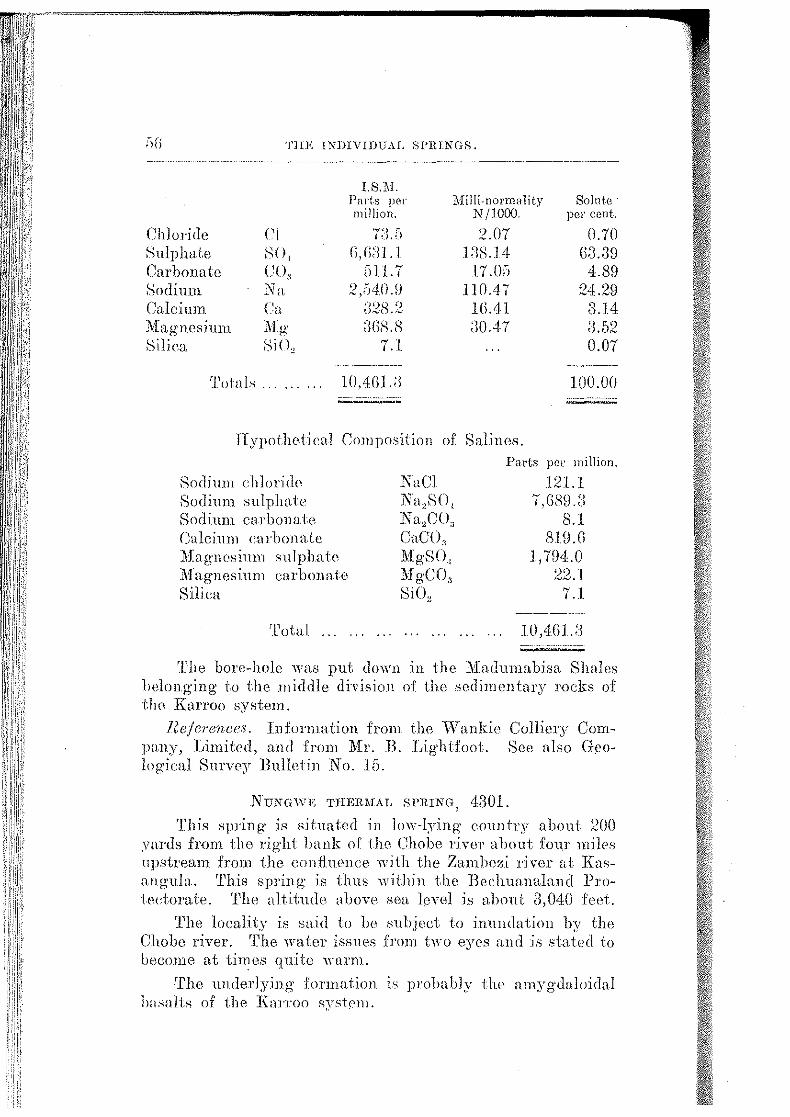
;)(j THE INDIVIDUAL SPRINGS.
I. S.M. Parts per lVIilli-normality Solntc · million. N /1000. pe-r cent.
Chloride Ci ""''J ;":' IU.d :2.07 0.70
Sulphate so, n, n;n .1 Jill-\.] 4 G3.39 Carbonate co, [Jll.7 .17 .O:i 4.89 Sodium Na :2 ,04.1UJ 11 () .4 i' 24.29 Calcium Ca a:?s.5: 1().41 3.14 Atfagnesjunt "fifo·
~ "!"':> ;)()8.8 :JOA7 3.52 Silica SiO, 7.1 0.07
-~----------- -···--
Totnl.s .. l0,4Gl.:l I 00.00 ------------ ·- .. ·········-------...___.......,__, ...
lTypothetical Composition of SaLines.
Sodium chlori(]p Sodium sulphate Sodiun.t carbmwte Calcium carbonate Magnesinm .sulphate Magnesium carbonate Silica
Tota.l . . . . .
NnCl Na,SO, "" c~~-~ l:i a2 , _ :1
CaCO" IlfgSO, Mg-CO, SiO,
Parts per rnillion.
121.1 7_\G89)~
8.1 Sl9.n
1,794.0 22.1 7.1
lO,'lGJ.:.J
The bore-hole was put down in the lliaclumabisa Shales lwlonging to the .middle division of the sedimentary rocks of the Knrroo system.
Refe-rences. lnfor1nation from the \Vankie Colliery Company, Limited, and from Mr. B. Lightfoot. See also Geolog·ical Sm·v0y 13ulleiin No. 15.
NUNGWE THERMAL SPRING, 4301.
'.!'his spring is situated in low-lying eountr~' about :ZOO 0rards from the 1·ight hank of tho Chobe river about four miles npstremn from the confluence w.ith the Zambm-..i river at Knsnng-uln.. 'l'his spring is thus within the Beehuanalancl l'rotectomte. 't'he altitude above sea level is about 3,040 feet.
'l'he locality is sa.id to be subject to inundation by the Chohe river. '!'he water issues from two eyes and is stated to become at times qu.ite "·arm.
The UJ)(]erlying formation is probably the amygcbloidal La.·mlts of the Km-roo system.

H.l.Tl'lSl HOT SPRINGS. 57
Analysis by E. Golding (19M) of '' specimen eollectetl on :21th December and received from 1.fr. J. A. Leg-ge.
On arrival at the laboratory the samplr' '"as fouud to be slightly turbid aH1l colourless.
I.S.~L Pa1·ts per million.
~I i lli-nonn>tlity Solute J~>tb. No. G. W. 17.
N itra.te Chloride Sulphate Carbonate Potassium Sodium Calcium Magnesium Alumina and iron oxide f::.>ilica
'l'obl
.:'\()" Ci sol co,. K
nil ,, "]() .-•.),iJ. .D
a,3GS.5 2.8.0
tra.ee Na :))l95. 7 Ca 425.9 Mg· 28.:1
s.o ~:~7.G
lO,S02.tJ
N' jlOOO. per cent.
H8.SD 70.1S
().!);;
147 .(i4 2UO
2 .:~4
a2.iili :ll .IS 0.2G
:nA+ :LD4 0.2fi
0.07 (). ;),-)
100.00
Hypothetical Composition of Salines.
Sodium chloride Sodium .'mlphate Calcium carbonate Calcium sulphate Magnesium sulphate Alumina and iron oxi1le Silica
'l'otal
NaCl Na0SO, CaCO, CaSO, MgSO, Al 20 3 ,Fe,<l, SiO,
Pm·ts prr mil!i(ill.
" 7°-1 " :), o .D
:·~' L1G5.] 70.0
1,:104.2 14<l..l
S.fl ~n.fl
It is classified as a imlpha.to-ehlori1le >nlier having sodium as the dominant kation. .
Information from Mr .. J. A. Legg-e, T\asane, and from 11r. A. Giese, T;nkosi.
J1UPISJ HOT SPRING, a10:3.
rl.'his well-known spring is tho source oJ' the Rupisi river, and is situat.nd about two milos north of the l\fusikiwam1 Native Reserve in tlw Melsettcr District, one and a half miles south of the Chipnngn river drift on tlw Sahi valley
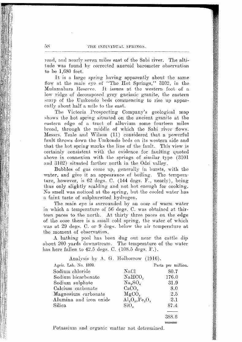
'J'HE INDIVIDUAL SPlllNG:S.
road, and nearly seven miles east of the Sabi river. The altitude was found by corrected aneroid barometer observation to he 1,680 feet.
It is a large spring havitlg apparently about the same flow at the main eye of "The Hot Springs," 3102, in the J\fubmabara Reserve. It issues at the western foot of a low 1·idg·e of decomposed grey gneissic granite, the eastern scn.rp of the Umkonclo beds commencing to rise up appaT'mtly about half a mile to the east.
'rho VictoTia Prospeeting Company's geological map shows the hot spTing situated on the ancient granite at the <'astern edge of n. traet of alluvium some fourteen miles broad, through the middle of which the Sabi river flows. ?!1:essrs. 'l'eale and "'Wilson (11) considered that a powerful fault throws down the Umkondo beds on its western side and that the hot spring marks the line of the fault. This view is eertainly eonsistent with the evidence for faulting quoted a.hovo in eonne:s:ion with the springs of similar type (3101 and ill02) situated farther north in the Odzi valley.
Bubbles of gas come up, generally in bursts, with the water, and give it an appearance of boiling·. 'l'hc tem.perature, however, is 62 degs. C. (144 degs. F., nearly), being· thus only slightly scalding and not hot enough for cooking·. No smell was noticed at the spring, hut the cooled water has a f~tint taste of sulphuretted hydrogen.
'l'he main Bye is surrmmded by an OOZf' of warm water in which a temperature of 56 degs. C. was obtained at thirteen paces to tho north. At thirty three paees on the edge of the ooze there is a small eold spring, the water of which was at 29 degs. C. or 9 degs. below the air temperature at the moment of observation.
A bathing pool has been dug out near the cattle dip about 200 yards downstream. 'l'he temperature of the water has here fallen to 42.5 degs. C. (108.5 degs. 1<".).
Analysis by A. G. Holborrow (1916). Agric. Lab. No. 1899.
Sodium chloride Parts per million.
Sodium bicarbonate Sodium sulphate Calcium carbonate Magnesium carbonate Alumina and iron o:s:ide Silica
NaCl NaHCO, Na2S04
CaCO" Mo·CO
b "
Al2 0,,Fe20" SiO"
Potassium and orgamc matter not determined.
80.7 176.0 31.9 8.0 2.5 2.1
87.4
388.6
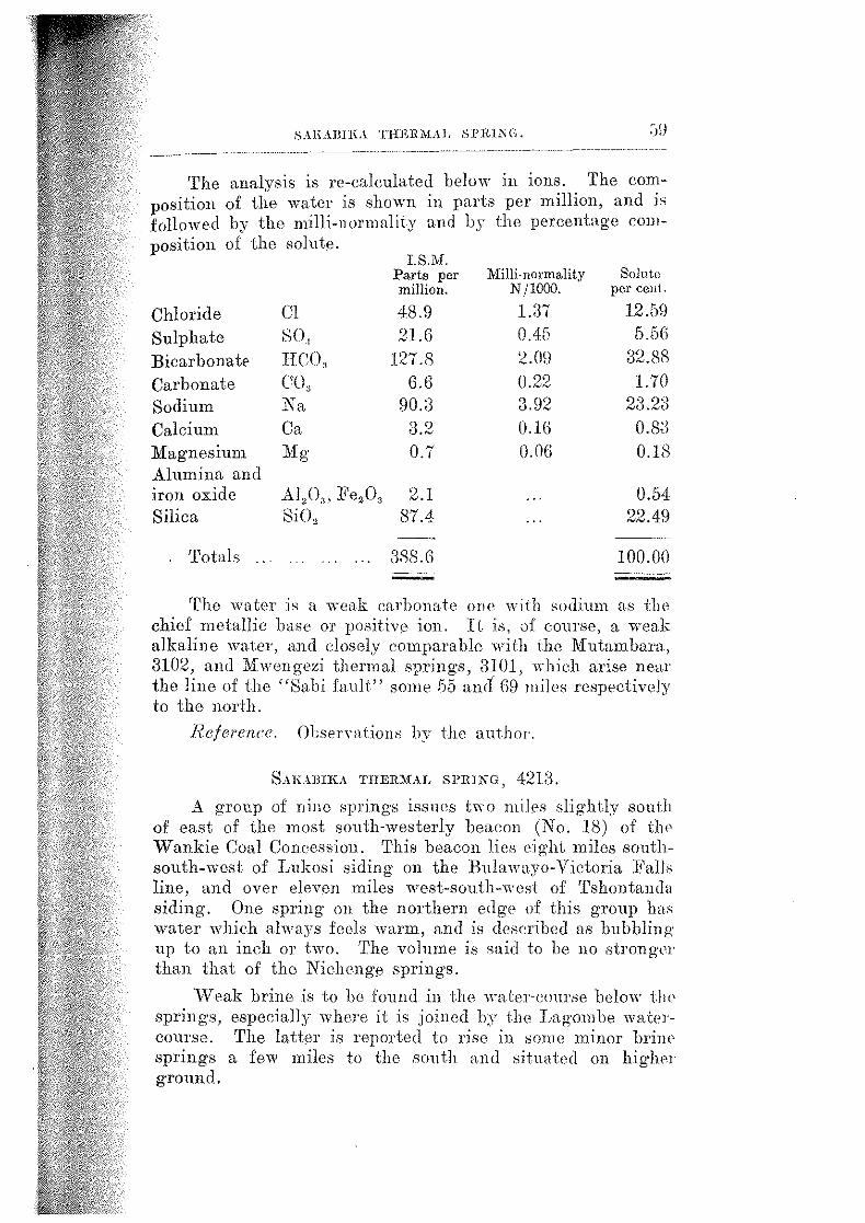
SAl\AilllLi THERMAL Sl'lt1?\C.
The analysis is re-calculated below in ions. The composition of the water is shown in parts per million, and j,
followed by the milli-normality and by the percentage composition of the solute.
Chloride Cl Sulphate 80, Bicarbonat~ HCO, Carbonate co, Sodium Na Calcium Ca Magnesium Mo·
b
Alumina and iron oxide Al/)3 , Fez03 Silica Si02
Totals ...
I. S.M. Parts per million.
48.9 21.6
127.8 6.6
90.3 30 .~
0.7
2.1 87.4
3.'l8.6
Milli-normality N jlOOO.
1.37 0.45 2.09 0.22 3.92 0.16 (). ()(i
Solute per ceut.
12.59 5.5G
32.?>8 1.70
')9 ')0 ..... u ,....,.tJ
O.B;l O.lf\
0.54 22.49 --~
100.00
'rho water i., a weak carbonate one with sodium as the chief metallic base or positive ion. It is, ,11 course, a weak alkaline water, and dosely comparable with the Mutamhan1, 3102, and Mwengezi thermal springs, 3101, which arise near the line of the "Sabi fault" some 55 all(I G9 miles respectively to the north.
Reference. Obsen-ations by the author.
8AILlBIKA THERMAL SPRING, 4213.
A group of nine springs issues two mil0s slightly south of east of the most south-westerly beacon (No. If\) of tlw Wankie Coal Concession. This beacon lies eight miles southsouth-west of Lukosi siding on the Bulawayo-Victoria Fall,; line, and over eleven miles west-south-west of Tshontandn siding. One spring on the northern edge of this group has water which always feels warm, and is deseribed as lmbbling up to an inch OT two. 'l'he volume is said to be no strongn than that of the Nicheng0 springs.
\V eak brine is to be found in the \Hlter-course below i:lw springs, especially where it is joined by the Lagom be wateJ·couTse. The latter is reported to rise in some minor hrinP sprmgs a few miles to the south and situated on higher ground.
(jl) TIU: lNDIVI!lUAL SPIUNGfi.
'l'he spring issuc>s from the ancient granite at some little distance south-west of the main southern-enstern boundary fault o£ the vVankie coalfield, by which the Karroo rocks are thrown down to the north-west against the Archaean granite.
Reje1'ence. Infonnation from J\Ir. A .. Giese, Lnkosi.
SJ.r.r:PAJL\.Ll}MA TH.ER1L\.I, sPRrNGs, a7o~1.
'l'he springs nre locah•cl in the nmth-e.astern corner of the Sehungwe District on ilw south hank of the Zam bezi river about four 1niles upstr<c'am from the confluence o:f the Sanyati nver. 'l'he altitude is about 1.550 feet above sea level.
'l'he water, where it issues from the several ori:Hces, is describod ns boiling. 'fhe overfi.o,,· into a swamp forms a deposit from which the local natives obtain their salt. 'fho mte of flow is stated to be constnnt..
1'he spriJJgs issue fron1 JntnH~l·ous crater--like openings in soft, boggy ground, forming iog·ether a pool about thirty iel)t in length and about ten feet wide.
Tho rock formation in that area is a sories o:f seclimenhiTy rocks belonging to the Karroo system. The Kapestt springs 4405, situated on the opposite hank of the l':ambezi riwr, issue from basaltic Lwa.
Refe1'ence. Information from '.l'rooper \\'. A. I-Iills, British South Ahica Police, dated 30th Jmw, 19:24.
f:>HAIV A THJlllii!AL Sl'IUKG 1 4[)()3.
A thermal spring issues near the road 'from Spungabera lo :M.:assnngena, eight miles south of the J\fossurize (Um-7,0lezwe) river and west of the ZinlnuJtbo hills in the Jlfossnrize province of I'ortngnese East Africa. This is apparently the Shaiva spring rderred to by :Messrs. Tenle and \.lfilson as hf1ing less powerful than 4502. It is also mentioned by 0. :F. de Andrade, who states that tho 'nders is;;ne from sandstone dipping beneath basalt sheets.
Tlwse rocks are doubtless of Karroo age. A.11.thon:tles. 0. E. Teale and ll. C. Wilson (11). C. ]•'.
,],. A JJ dracle ( 12) .
Snnr.nA TrmmiAL sPRINGS, 4207.
The springs are situate,d on the east bank of the Shumlm 1·iver and about three mile,; from Tshabi's old kraal on the Jlilihizi river, \.lfankie District. '!'he road from vValker's Drift on the Zambezi riwr, at about eighteen miles south l'nnn the river, pusses close to the springs.

iil.BlLA TIIER1IAL SPRING.
The group eoHsists of four powerful springs rising within a few yards of one another, and estimated to have a total flow of five to ten thousand gallons an hour. The water is "·arm, and described as somewhat bitter but potable.
The Shumba river, a few miles below the SJll'iHgs, passes over a tract of level ground, where a white deposit of salt has been formed. The loeal natives obtain their salt from this· .-;ource and it is a favourite "salt-lick" for game.
1'he r·oek formation in the area is a scrie.s of sedimentary rocks belonging to thr" Karroo system.
Reference. Unpublished communication from J\fr. F. ~~r. 1'. Possdt, r·eceived lOth November, 1910.
SnnLA 'J'HERMAL SPRL'\T{, 3705. 'rhe sp1·ing is situated at the foot of a kopje on the north
side of the J\fatoholo flats in the Selnmgwe District. It was one of the watering places on the old road from J3ulawayo to Jjubu camp in the Sibaba Native Reserve, and it is estimated to be about 22 miles south-east of the old camp Kariyangw(;.
Tlw water is said to issue slowly in small but con.stant Yolume through mud and to form a "·et vloi about twenty yards long. It has a slight smell of sulphmetted hydrogen. 'rhe name indicates boiling water, but it is described as appreeiably warm. Apparently it has no noticeable taste ancl was eonstantly used for cooking and drinking without ill eJl'ects, the smTomHling area being 1nderless, nt any mte i11 winter.
'rhe M:atobolo flats ,,outh of the localit:.r are described as mud flats scatterell over by round nodules of limestone, whieh indicates that the flats are underlain by the J\fadumabisn Shales of tlic• KaJToo system.
Reference. Information hom J,t.-CoL Carhult, Chief Native Conunissiouer, 193.3.
SnmNIH TimR>HL sl'IUNl;, 4205. The spring is located on the right (south) bank of the
Zamhezi river about thret' miles upstrPam from the confluence of the Matetsi river nt an altitude. of abou.t 2,000 feet above
level. 'L'he cmli1uence is situated in the \.Vankie Distriet <tllOlilt 25 miles east-north-east of \Van.kie township.
The spring is n'ported by natives to be very hot and to much salt.
that locality Hows oYer basaltic ,ci}JJv"'·' of I(arroo age.
Refere11ce. 1nformntion from Mr. F. ·w. '!'. :PosseH, a.tiYe Commiss·ioner.
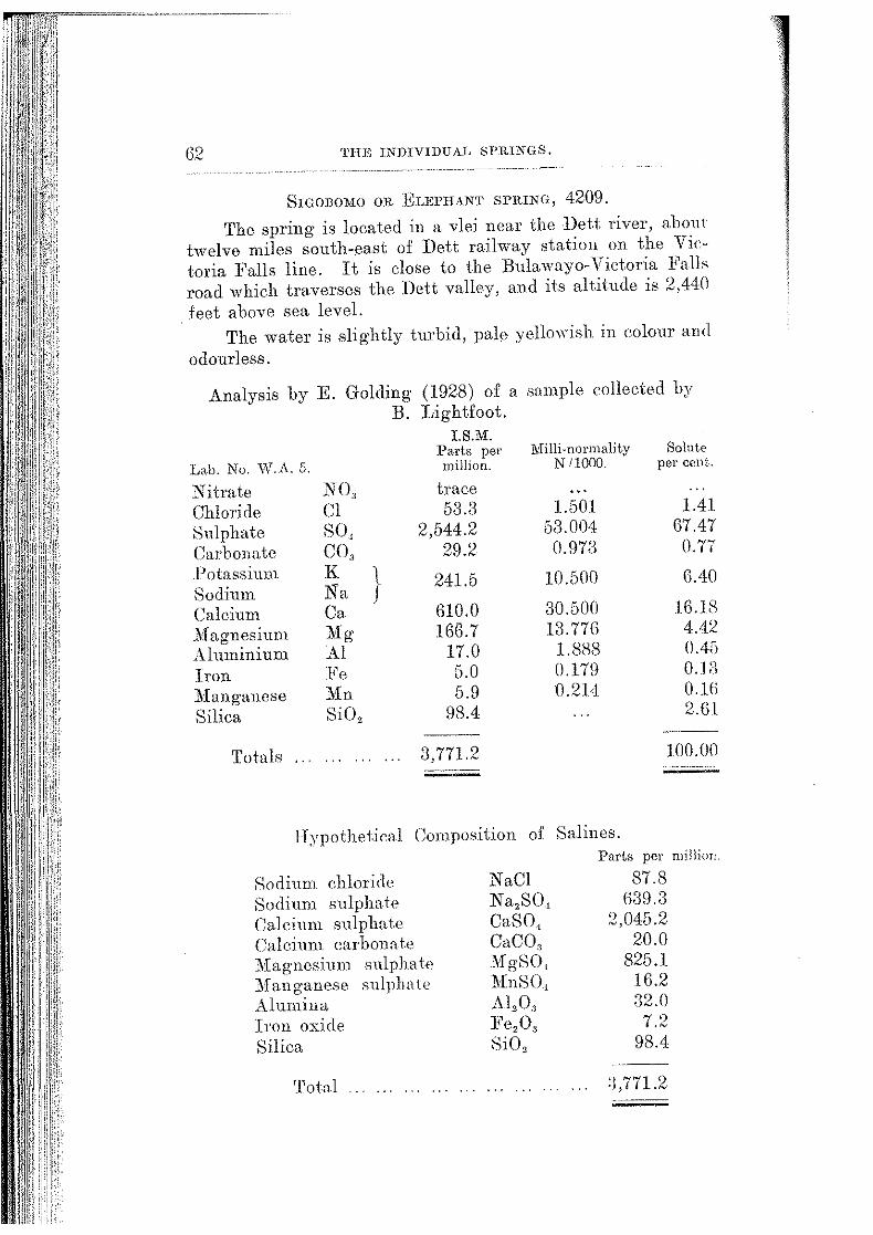
62 TH.E INDIVIDUAL SPRINGS.
SrGOBOMO OR ELEPHANT SPIUNG, 4209. The spring is located in a vlBi near the Dett river, about
twelve miles south-east of Dett railway station on the Victoria Falls line. It is close to the Bulawayo-Victoria Falls road which traverses the Dett valley, and its altitude is 2,440 feet above sea level.
The water is slightly turbid, pale yellowish in colour and odour less.
Analysis by E. Golding (1928) of a sample collected by B. Lightfoot.
I. S.M. Parts per Milli-normality Solute
Lab. No. \V.A. 5. million. N 11()(10. per ceut.
Nitrate NO, trace Chloride Cl 53.3 1.501 1.41
Sulphate so, 2,544.2 53.004 67.47
Carbonate co, 29.2 0.973 0.77 l)otassium K l 241.5 10.500 6.40 Sodium Na j Calcium Ca 610.0 30.500 16.18
il1agnesium ~lg 166.7 13.776 4.42
Aluminium AI 17.0 1.888 0.45
Iron :Fe 5.0 0.179 OJ;)
:Manganese Mn 5.9 0.214 O.lG
Silica SiO, 98.4 2.G1
Totals 3,771.2 100.00
Hypothetical Composition of Salines.
Sodium chloride Sodium sulphate Calcium sulphate Calcium carbonate ·Magnesium sulphate :Manganese sulpha le Alumina Iron oxide Silica
Total
NaCl Na,SO, CaS0 1
CaCO, 'M'gS0 1
MnSO, Al,O., l<'e,O, SiO,
Parts per million.
87.8 639.3
2,045.2 20.0
825.1 16.2 32.0 7 ')
oN
98.4
:},771.2
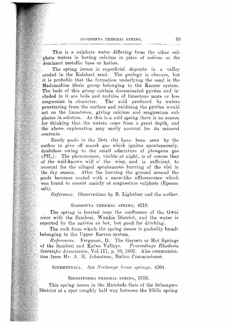
SIGOBONYA THERMAL SPRING. G3
This is a sulphate water differing from the other ~ulphate waters in having calcium in place of sodium as the dominant metallie base or kation.
The spring issues in superficial deposits in a valley eroded in the Kalahari sand. 'l'he geology is obscure, hut it is probable that the formation underlying· the sand is the Madumabisa Shale g-roup belonging to the Karroo system. The beds of this group contain disseminated pyrites and included in it are beds and nodules of limestone more or less magnesian in charac-ter. 'l'he acid produced by waters penetrating fron1 the surface and oxidizing· the pyrites would act on the limestones, giving calcium and magnesium sulphates in solution. As this is a cold spring· there is no reason for thinking that the waters come from a great depth, and the above explanation may easily account for its mineral eon tents.
Reedy pools in the Dett vlei have been seen by the author to g·ive of[ marsh gas which ig·nites spontaneously, doubtless owing to the small admixhue of phosgene gas (PH,). 'The phenomenon, visible at night, is of course that of the well-known will o' the wisp, and is sufficient to account for the alleg·ed spontaneous burning of the vlei in the dry season. After the burning the ground around the pools becomes coated >~·ith a snow-like efflorescence which was found to eonsist mainly of magnesium sulphate (Epsomsalt).
l~efe1·ence. Observations by B. Lightfoot and the author.
SIGOBONYA THERMAL SPRING, 4210.
The spring is located near the confluence of the Gwai river with the Zamhezi, vVankie District, and the water is I'eportecl by the natives as hot, hut good for drinking.
The rock from which the spring issues is probably basalt belonging tD the Upper Karroo system.
References. Ferguson, D. The Geysers or Hot Springs of the Zambesi and Kafue Valleys. Yroceedin,r;s Rhodesia Scientific Associatl:on, Vol III, p. 10, 1902. Also communication from Mr. A. H. Johnstone, Native Commissioner.
SrNEMENTALA. See Nic!wn,r;e brine SZJJ'in,r;s, 4204.
SrNESITONIW THEHMAL SPHING, 370G.
This spring· issues in the .Matobolo flats of the Sebungwe District at a spot roughly half way between the Sibila spring
G4 Tim INDIVIDUAL SPRINGS. --------------------·-----
a705 and Gololo hill where Nkaka's kraal once stood. 'l'he locality is not well defined, but is probably between three and five miles north-north-east of Sihila vlei. The spring derives its name from the chief who lived near it until the natives were moved off the flats on aecouut of sleeping· sickness.
The spring has a considerable volume, the water flowing· off in a well-defined channel through black soil towards tlw left bank of the l3usi river. At tho eye the water is distinctly hot, and there is a smell of snlphuretted hydrogen, especially when the mud is stirred up.
'L'he formation from which it issues is probably, like that of the Sibila spring·, the J\1adumabisn Shales of the Karroo system.
He.ference. Information from JA.-Col. Carbutt, Chid Native Connnissimwr.
Sl'RING, 3901. A cold spring issues beside the old road from Odzi to the
Umkonclo copper mine half a mile north of the drift through the Sabi riv(')r and in the Umtali District. The drift is about three miles upstream from. the confluence with the Odzi riYer. 'l'he spring· water .Jeposits a white salt said to be so<lium earbona te.
!l11!:hon:t;y. Mr . .T. L. ]\'[artin, M.l'.
SPRING, 440G.
'l'he spring is situated near the road from Walker's Drift to Monze (Northern Rhodesia), about 4 miles north of the Zambezi rive!".
This small spring issues high u.p in hills of "crumple<] ;o;andstone."
l<e.fePence. ]'erguson, D. The Geysers or· Hot Springs of the Zambesi and Kafue Valleys. Proc. Hhod. Sc£. Assor·. Vol. III, p. 10, Ul02.
SPRING, 44-07. 'l'he spring is situated near the road from ·walker's Dr.if1
to Monze (Northern Rhodesia), at the foot of the Batokaland plateau. It is about 27 miles north of the Zamhezi river.
'l'he description suggests that this spring is a gusher of low temperature. 'l'ravertine dqJOsits arc associated with the overflow water.
SULPHUR SPRING, 4202.
'rhe formation from which the spring issues is not known.
Reference. Ferguson, D. 'rhe Geysers mt<l Hot Springs of the ll,ambesi and Kahw Valley:;. !'roc. Hhod. Sci. A.ssoc. Vol. III, p. 10, 1902.
i-1VL1'JlFR Sl'l\ING, 4202.
'rhe po.:.;ition of this spring is plotted 011 the geological map accompanying Southern Rhodesia Geologica.! Survey Bulletin No. 4. It is located on the right bank of the Dekn river,. about twenty miles south-west of the Deka bridge Oll
the Bulawayo-Vietoria Falls railway line, \Vankie Districi, and the altitude is about 2,600 f:eet.
'!'he spring comes to the surfac0 i.h1·ongh the Batob1 Bnsalts of Karroo age.
Reference. Information from 1\[r. B. Lightfoot.
Su1.Pnu1wus sPnmo, :no4. A vory snmll spring trickles out of rock on the eastern
face of a hill ca.lled 'rambat.sura on sheet 18 of the J: 260,000 map of the Colony, and situated about two miles north of the Nyautsa river and ahont fivB 1niles west of Redwoo<1 farm, J\1.elsetter District. North and east of it are oltl copper .elaims pegged at first as the J\1afonni mHl later as the Chi-impi elnims.
The water is cold awl snwlls of rotten egg., (sulphuretie<l hydrogen), bnt can be used for cooking and drinking.
A uthon:ty. .i\1r. ,J. L. 11Iarti n, ::H .I'.
i:JUNGA Tl!EIC\J..\L SPRING.,, 4.208.
'!'his group issue.s in tho Deka river nine miles LeloiY the Deka railway bridge on the Bulawayo-Victoria :Fails line, vV ankie District. The position is shown on the maps accompanying Geolog·ical Survey Bulletins 4 nml lfl, and the altitude is 1,900 feet ahoYe sea hwel.
'l'ho main eyfl emerges right on the line of the important Ikka fault, which extends in !1oth north-<Jast and s<mth-west directions for upwards of forty miles. '!'he Batolm Basalts
the north-west of the fault havo been Jet down against the Escarpment Grits on the south-east. At tho point of eJJam·u·ence a subsidiary fault has caused a slig·ht kink in the main fault. 'l'his spring is an impmta.nt contributor to tlw
ankie water suppl:v. Tts flow has Jl<'Ver heen known to

:: ' 1'i
r :J! :1
!I ,I ' I I 11 ' ' i' '1i i ilr I
:II 'I il, ,:!;, TIIB INDIVIDUAL SPRINGS.
fall below 25,000 gallons per hour in the dry season. 'rhe water is warm to the hand.
The water of the main spring was analysed by Mr. Geo. Ping stone for the W ankie Colliery Company, I-'imited, and 1s published below by permission of the General :Manager.
Analysis by Geo. Pingstone (1920).
Incrusting Solids. Non-incrusting Solids. Grains per
gallon.
Calcium carbonate 9.45 Sodium
Calcium sulphate nil Sodium
Calcium chloride nil Sodium
lliagnesium ear bonate 4.41 Sodium
:Magnesium sulphate nil
Magnesium ehloricle nil
Alumina and iron oxide 0.45
Siliea
Totals
l'ounds of incrusting solids in one thousand g·allons Alkalinity
Hardness Carbonie acid
2.52
16.83
2.40
22.75 6.65
10.01
sulphate
chloride
carbonate
nitrate
Grains pf>t'
gallon.
6.46
8.54
8.52
traces
23.52
"The foregoing figures of analysis shows this to be an alkaline spring water. It is scarcely to be classed as a medicinal water althoug·h it contains some sodium earbonatc n.nd sodium sulphate, the amuunts being very small.
"For boiler purposes this would not be so bad, as owing to the presence of sodium carbonate the bulk of the lime aml magnesia salts would be thrown down as a shulge on heating and could be blown off from time to time.
(Signed) Geo. Ping stone."

A.
B.
PLATE II.
PHOTO. C. F. MOLYNEUX
Chilambwa Thermal Springs, No. 4403. About 5 miles from the left bank of the Zambezi river, Makabuka District, Northern Rhodesia.
The main eye at "The Hot Springs," No. 3102, Mutambara Native Reserve, Melsetter District.
PHOTO. H.B.M.
in the Sabi Valley.
ZINCO COLLOTYPE CO •• EO!NBUI!GH.

SVNGA THJ<JR:MAL SPRINGS. 67
The table below shO\vs the analysis re-calculated m ions. The composition of the water is shown as parts per million, and is followed by the milli-normalit.y and by the percentage composition of the solute.
Chloride Sulphate Carbonate Sodium Calcium Magnesium Alumina and iron oxide Silica
01 so ·l co" Na Ca Mo·
"
Totals ..... .
I.S.M. Parts per million.
74.0 62.4
198.6 126.7 54.1 ]8.2
6.4 3G.O
676.4
l\Iilli.normali ty N /1000. 2.08 1.30 6.62 5.fll 2.71 1.60
Solnte pet' eent.
12.88 10.1l:3 84.4G 21.98
9.38 a.1G
1.11 G.25
100.00
'fhe water may thus be classed as a very weak carbonate water with sodium as the principal metallic base or positive lOll.
Mr. P. B. ~fack, Industrial Chemist to the Vi! ankie Colliery Company, Limited, states that two minor spring·s issue about 20 to 30 yards from the main spring, one having a temperature of 38 degs. C., the other a temperature of 37 degs. C. An analysis of the former fqllows. In the last column the original figures in grains per gallon have been re-calculated in parts per million for the sake of comparison with other figur('S.
Analysis b:y P. 13. Mack (193a).
Calcium carbonate Magnesium carbonate Iron and alumina Silica Sodium sulphate Sodium chloride Sodium carbonate
'fotal .. . .. .
Grains per gallon. 9.01 il.G8 0.11 2.81 6.92 8.7il 8.87
40.13
Parts per million. 128.7 62.6
1.6 40.1 99.0
124.7 126.7
57il.4
Alkalinity in terms of sodium carbonate 23.1 The above analysis was re-calculated into the standard
units used throughout. this work as follows:-

(58 TIIJ;; INDIVIDUAL SPJUNGS.
Chloride Sulphate Carbonate Sodium Calcium .Hagnesium Alumina aml iron oxide Silica
I.S.i\f. Parts por millioz1.
Cl 75.G so, 67.0 co, .186.8 .Nu Ia6.1 Cn, [).1..~~
11g 1[).2 Al 2 0,,l?e)\ J .6
40.1
'l'otals ... Ctf3.4
?dilli-normality N /1000.
2.1~l 1.40 G.21 5.fJl 2.58 l.2T)
Solute per cenl.
13.19 11.69 82.4fJ
8.98 2.6D 0.28
G.99
100.00
Small mineral yeins are associaterl with the faulting in iho hillsides near the Sunga pump, and are composed. of c.omby lJUnrh \Yith a deposit of mammillated psilomelaJw (manganese dioxide) in the centre of tho Ye.iJL
Bejerence. Lightfoot, 13. 'J'he Geology of the Cenllal Part of the \Vankie Coalfield. Sonthern Rhodesia Oeo 7og·£eal Sni'1Jey Hutletin No. 15, p. 5fJ. Salisbury. J!J29.
"TnE HoT S:P1UNGs," MuT.1MB.\KI NATIVE HEsi-11\VE, :1102.
't'hese springs an\ known as "The IIot Springs" and are the only ones in the country at which an eAtahlishment has been sot up to aid in the use of the wi1ters for health purpoAes, though a bathing pool has been dug i11 the outflo\\· of the Rupisi springs, ;no;J. 'J'he natives call all thernwl springs in the .M"dsetter Distriet "rupisi," hut the nanw. is at.laeherl by Europeans to one partieular spring (:DO:l). Mr . . r. L Marlin, M .l)., points out as probably more than a coineidenee that the chiefs in whose lands these "rupisi" ·'lwings are situated nre end1 named Chibuwe.
'L'hese Aprings are sihwterl in the Mutamhara Re.serve in the llfelsetter Distr.ict about 8;J() yards east of the Odzi river, on the very edge of the Umtali-Chipinga road, 10} miles south of the Fmvnmvnvu ri.-or and 9 mile.s north of tlw Xyanyaclzi river. '!'he altitude was found by corrected aneroid barometer observations to he just under 2,000 feet.
'l'he springs issue in two groups, the southerly one being hotter, greater in volume and the one on ''" hieh bnt.hing pools are establi.she<l nt 'l'he Hot Springs TJotel prr. 11. \V. Krynes).
In "Plate II, B the \rhitened stones mark the edge of ihc Umtali-Chipingn road. '!'he main eye is just lwlow tlw

'''fHE HOT SPRIKGS," 1IU'L\.MHARA.
with a subsidiary eye dose to it. A third eye, qbviously of lesser volume than the other two combined, issues into the dark pool on the left of the photograph. 'l'he combined flow was estimated by means of tt notnh to be about 3,300 gallons pllr hom.
'l'he temperature of the water ohserve<l morning and <wening for a few days 'nts found to he GG <legs. C. (lil~l <legs. F.), falling once or twice to 55} degs. 'l'he temperature of the water at the third eye was also GG degs. C. '!'he water is too hot to hold in a. metal cup, but is just not too hot to drink. The water from the main eye gushes up about eight inehes, nncl carries up small stones with it. Bubbles of ga.s come up every now and then. 'l'he water tastes of sulphun•ttwl hydrogen, hut not so strongly us tlw M wengezi watl~r CHOI). 'l'his taste passes away eompletely ·when tho water is allowed to stand and cool down.
'l'he seeoncl group of springs lies 400 yards to the north and just on tho west of the roa<l. "B" spring .. 30 yanls from the road, issues from below an outerop of redclene<l granite into a quiet pool at n point where the smHl appean; to boil. The highest temperature obtained lwre was 46 <legs. C. (118 dogs. F.). Bubbles of gas rise 11p every ten or twelve seconds through the wnier which feels warm and tastes of rotten eggs.
"C" · . ' t ' i l sprmg, wur een paces ,o o.1e ,;mall spring with a tempernhtre of degs. F.).
north, is a similar 4'1 clPgs. C. (111
"D" spring is situated about 40 paces to the northwest and at a lower level. Four Clyelets four to eight inches apart discharge from a horizontal craek in a dark grem1ish igneous rock, which seems to be an altered <lolerite. 'l'he temperatnre in the main eyelet was :)()<legs. C. (90 <legs. F.). 'l'he water feel.~ just wnrm aml tastes only slightly of sulphuretted hydrogen.
'l'he sample from which tlw 1 U2l analysis was made \\"as submitted by the Assistant Director of Land Settlement to the Chemieal Laboratory of the Deparhnent of AgTic:ulture. 'l'wo bottles were sent in mH1 it was not stated from which eye the water was take11, or whether tho sample was a mixetl one taken from clifl'orent springs. In any case the analysis was made on a sample ohtainetl by mixing equal portions of the eontents of both bottles and iilteriHg.
The sample from ,.-hich the 1929 analysis 'nts made was collected by the author front the pool as near the main eye as possible in two \VinclHJster quart stoppered bottles.
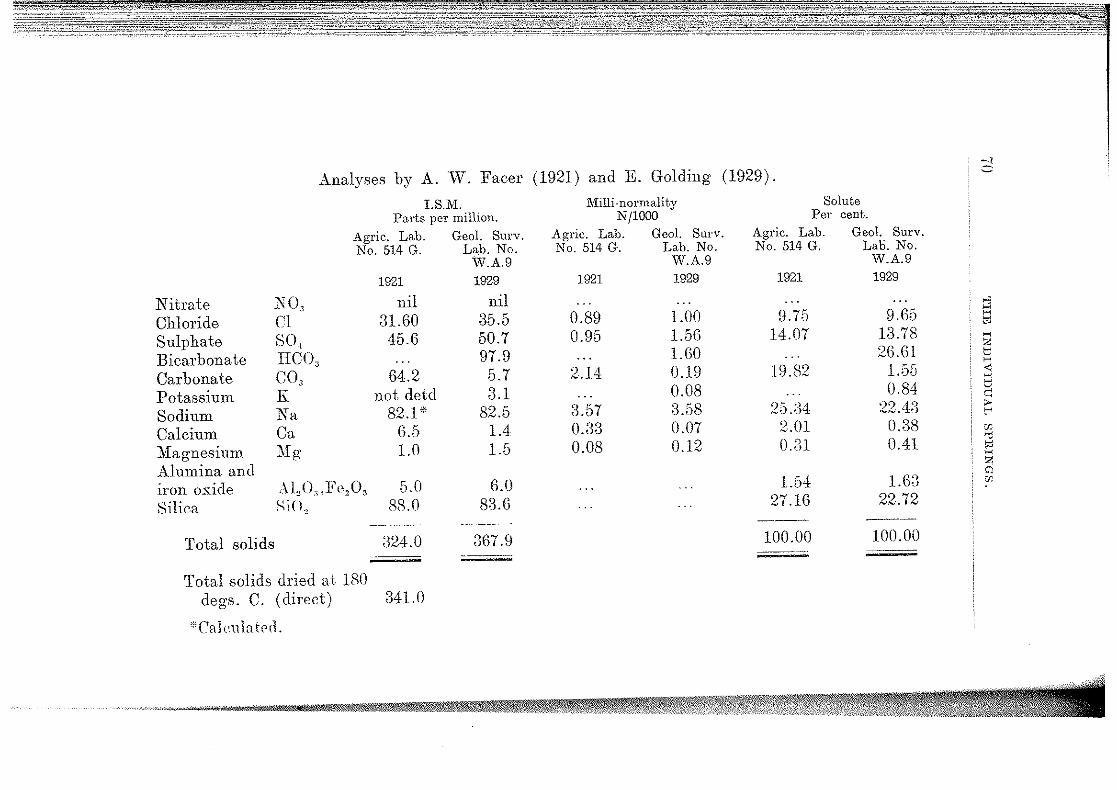
Analyses by A. W. Facer (1921) and E. Golding (1929).
I. S.M. Parts per million.
Agric. Lab. Geol. Surv. No. 514 G. Lab. No.
W.A.9
1921 1929
Nitrate NO, nil nil Chloride (;1 31.60 35.5 Sulphate so, 45.6 50.7 Bicarbonate nco, 97.9 Carbonate co.) 64.2 5.7 Potassium K not detd 3.1 Sodium Na 82.1 * 82.5 Calcium Ca 6.5 1.4 :Magnesium }fg 1.0 1.5 Alumina and iron oxide Alo<.\.1'<>2 0, 5.0 6.0 Silica SiO, 88.0 83.6
-~-- -~·--·--
Total solids 324.0 367.9 --~---
Total solids dried at 180 degs. C. (direct) 341.0
''Calc11hterl.
l\iilli-normality Nj1000
Agric. Lab. Geol. Surv. No. 514 G. Lab. No.
1921
0.89 0.95
2.14
3.57 0.33 0.08
W.A.9 1929
1.00 1.56 1.60 0.19 0.08 3.58 0.07 0.12
Solute Per cent.
Agric. Lab. Geol. Surv. No. 514 G. Lab. No.
1921
9.75 14.07
19.82
25.34 2.01 (U\1
1.54 27.16
100.00
W.A.9 1929
9.65 13.78 26.61
1.55 0.84
22.4:3 0.:38 0.41
1.63 22.72
100.00

"TilE HOT SPRINGS," MUTAMBARA.
Hypothetical Composition of Salines.
Potassium chloride Sodium chloride Sodium sulphate Sodium bicarbonate Sodium carbonate Calcium carbonate Magnesium carbonate Alumina and iron o:s:ide Silica
Totals ...
KCI NaCl Na,SO., NaHCO, Na,CO, CaCO, MgCO, Al,O,:Fe,O, SiO,
Parts per million. 1921. 1929.
52.1 67.4
91.8 16.2 3.5 5.0
88.0
324.0
5.8 54.1 75.0
134.8
3.6 5.0 6.0
8a.6
367.9
71
'fo the west of both groups of springs the cOl\ntry down to and across the Odzi rivor is underlain by the quartzites of the Umkondo system. 'Whilst these quartzites usualiy lie horizontally or nearly so, they are here greatly disturbed and dip at angles varying· from 25 to 45 degTees to the west. :East of the springs the country is underlain by granite, which about a mile and a half east of the road rises up in to the precipitous hill called Dokotok. rrhe base of the Umkondo bods, which form the higher hilLs of the scarp still farther east must lie at a considerably higher altitl\de than "The Hot Springs." It is in fact quite dear that these springs issue very close to, if not actually on, the line of a large fault throwing down to the west, and that it is tho one described by Jl.fr. F. 1'. :Mennell (a) as the Sabi fault.
One hundred and fifty yards to the north of the northerly group of springs a donga exposes red and grey granite with a dolerite dyke about 80 yards broad. The dolerite is shattenld, altered and in places veined by quartz. It is no doubt a continuation of the .still more altered rock from which the "D" spring issues.
The. water may l1e classed as a weak alkaline carbonate water containing Vl4.8 parts of sodium bicarbonate per million. Apollinaris waters contain 1352 parts of sodium bicarbonate per million.
'!..'here appears to he no reeord of the therapeutic valuo of the water.
Heje1·ence. Observations by the author.
'l'H.E lNDIVlDU A.L Sl'RIN G S.
'J'HEIL\IAL SPRING, 2604·. Situate<l 011 the right hank of the Channa river and west
of Nyagatonoro h.ill on the loft hank. 'l'he loeality is state<] to he upstream from. the eonfiueneo of the 111wemhusa river near a foot-path coming from the east.
Reported by 1\Ir. John Danks, .Nlem. Sth. Afr. Insi. Civ. }~ng.
'J'UEJL\1.\L SPRiNG, 3704.
The spring is situute<l in the Sebung11·e District about three miles from the confluence of the Masumo river with the Zambezi. 'l'hn conlluenc:e is about 90 m.i.les north-east of \Vankie t<l\nwhip.
The mck formation of the area aronw1 the confluence is a se<linwnim·y sPries of sa!Hlstones, grits and shales of Kanoo age.
TnmnLu. sl'RlliG, 4•±01. 'l'he spring is located on ilw left (Northern Rhode.sin)
bank of the Zambezi river about one mile he.low the confluence of the :'lfatetsi river. 'l'he confluence is a.hout 20 1niles east-north-east of VVankie township, and very roughly. about 2,000 feet above sea-level.
It is stated that the temperature is high, the flow considerable, and that the water contains salt.
'l'he spring rises a few yards from the waters of t);p
;l,ambezi, issuing from the Batolm Basalt formation of l{n.rroo age.
Hefer·enne. Information from M1·. F. \\'. T. I'ossel!, X.C., date<1 2bt Xovemlwr, HJll!.
Tnmtl\L\L Sl'HING, <±501.
A tlwnnal spring issups near the south-western COl'lll'l'
of tlw Sitatonga rnnge and perhaps three quarters of a mi], south of the Lusitu river in tho north-\Yestern corner of the }iossuriz<' province of Portuguese East Africa .
. lutlwrity. :\lr. ,J. L. Martin, M.P.
TIIEIDL\L ·SPRING, :J50.2. A therlllal .spring· i.ssues at. the south end of the
Sitatonga range and within a mile of tho J{usi r.iver, Mossurize provinec of l'ortugueso East Africa.
Lluth01·£ty. .Mr . . T. L. Martin, 111.1'.
Also men t.ionecl li:v 1\1 essrs. Teale and VVilson ( 11) a ncl C. F. de Andrade ( 12).

ZO:IlllA 'l'HER:IIAL Sl'l\ING.
1VEN<:EsT. See JliwengezZ: the,·nwl sprinr;, 3101.
hmlHA T!IlW~!AL Sl'RING, 41()1.
,...-,) /r_)
A thenna.l spring of very small volume issues in a depression on the right hank of the :1\H.ilikwe river in the south-cast corner of the Nyajena Native ltescrve half a mile to a mile north of Zomba mountain, whieh hears the corner heaeon of the reserve. 'l'here is a slight smell of sulphurotted hydrogen. 'l'he country is underlain by granitP.
lnfonnati_on from Lt.-Col. Cm·buti, Chief NntiYo ComllllSslOner.
ZoNC:.\LA. See Kabira g1;.s/wr, ~n01.

7 4 LIST OF REFRlmNCI<)S.
LIS'l' OF REFERENCES.
(1) FERGUSON, D. 'l'he Geysers or Hot Springs of the Zambeei and Kafue Valleys. Proceedings of the Rhodesia Scienttfic Association. Vol. III, pp. 9-20. 1902
(2) MoLYNEUX, A. ,J. C. 'rhe Sedimentary Deposits of Southern Rhodesia. Qum·te,.Ly J o·n1·nal of the Geological Society. Vol. LIX, p. 282. 1903.
(;3) J\hNNELL, .F. P. 'l'he Geology Rhodesia /duse1t:m, Hulawayo. 1904.
of 8outhern Rhodesia. Spec·ial Re]JO?'t No. 2.
(4) LIGHTFOOT, B. BuLLetin No. 4.
Sontlwrn Rhodesia C/eological Sm·cey Salisbury, 1914.
(5) RrNDL, M. NI. The :I.Iedicinal Spring~; of South Africa. South llf1·ican J otwnal of Sc1:ence. Vol. XIII, No. 10, 1917.
(6) GEOLOGICAL SuRVEY. Provisional Geological Map of Southern Rhodesia, 1921. Second edition, 1928. Salisbury, Southern H.hodeBia.
(7) l'trNDL, M. M. 'l'he J\Iedieinal Springs of South Africa. Supplement II. Srw.th African Jou1·nal of Scien<:e. Vol. XXV, pp. 116-126. 1928.
(8) LIGHTFOOT, B. 'l'he Geology of the Centml Part of the \Vankie Coalfield. Southe1·n Rhodesia C/eoLogical Sn1··vey BulLetin No. 15. Salisbury, 1929.
(9) MAcmmGoR, A. M. The Geology of the Country around Que Que, Gwelo District. Sonthern Rhodes1:a, Geological SnJ'1!e1f lildletin No. 20, p. 66. Salisbury, Hl32.
(10) Report of Couneil .Medical Hydrology. Anno. VII, No. 1, 1929.
of the International Society of Anhi10es of Jfedical Jiyd1'olopy.
Jlp. .153-156. London. January,
(II) 'l'EJALE, K 0. AKD \Y nsox, H.. C. Portuguese East Africa between the Zambezi river and the Sabi river: " consideration of the relation of its tectonic and phyBi<1-graphical features. The CJeop?'aph,ical .1 oumal. Vol. XLV, p. ;36. January, 1915.
(12) DE ANDRADE, C . .F. EshOgo geologico da Provincia rle J\'Iogambique, pp. 198-201. Lisboa, 1929.

INDEX.
Les Ba.ins, France Analyses of some European and South African mineral w;tten; 'j'\nalyses, international standard measurements used in the .Analysis of brine near springs, Nichenge (G. A. Pingstone)
brine from Sinementala claims, Nichenge (E. Golding) compos_ite sample of brine, Niehenge (E. Golding) efflorescence, l\1endayats·wa ooze (E. Golding) incrustation, Chipiso {E. Golding) incrustation on surface of soil, Lubimbi (A. Y.l . . Facer) incrustation at eye of spring, Lubimbi (A. W. l<'accr) salt deposit, Kalishe swamp (E. Golding) water, Chawato (E. Golding} water, Chipiso (G. N. Blackshaw and g, Golding) water, Dunstan (E. Golding) water, Gobo (E. Golding) water, Kabira (D. Ferguson) water, Kalishe swamp (G. A. Pingstone) water, Lubimhi (A. W. Facer) ... water, l\Tendayatswa ooze (E. Golding) wa.ter, ~1wengezi (A. G. Holborrow) .. water from thermal eye, N idwnge (:E. Golding) water, No. 9 bore-hole, VVankie (G. A. Pingstone) \Vater, Nungwe (E. Golding) water, B..upisi {A. G. Holbonow)
PAGE
21 20
24-5 49-50
52-3 51 45 33 43 44 40 26 31 34 35 37 39 42 46
47-8 54
55-6 57
58-9 62
66-7. 67-8
water, Sigobomo or glephant spring (E. Golding) water, main spring, Sunga (G. A .. Pingstone) water, mmor spring, Snnga (P. B. fllaek) water, "The Hot Springs," :i\Iuta.mhara (A. VV. Facer
70-l . 60,72
and E. Golding)
Andrade, C. F. de
Banks, J. 72 20
Bath, England Bechuana.land Protectontt-e, Bicarbonate waters
springs near bonbr .. J 0, 22, 24 . 16, 22
9, 25 ... 32, 33
. 10, 15, 16, 17, 54-6 . 7, 24, 27, 38, 41, 49, 59, 60, 61,72
Bidida thermal spring Blackshaw, G. N .... Bore-hole No. 9, \Vankie
Calcareous sinter Caledon, C.P. Carbonate waters Carbutt, Lt.-Col CauteretsJ France Chalybeate waters Chatenta thermal spring, s('.e Kapesa Chawato springs Chigwadada. thermal spring Chila.mbwa thermal springs Gh.ilundu springs Chimanimani geyser
· thermal spring therma-l spring
Composition, cla.ssifiea.tioll of mineral waters hy (~nmming, H. H.
24 20
. 16, 18, 20, 22, 64 ... 61, 64, 73
21 ...... 16, 20
.. 10, 25, 40-1, 60 .. 9, 16, 17, 25-7, 53
. 10, 27 .. 10, 27 . 10,28
8, 28 .. 8, 17, 24, 29-33
.. 8, 27-8 . 16, 17, 20, 22
17-8 . . 51, 52, 53, 54

7G IN VEX. ------- --·--··--······~---~~----··-------------~----
Deka fault Deposits from the mineral sprmgs
calcareous sinter siliceous sintel' sodi urn carbonate sodium chloride sodium sulphate stllphur travertine
Depth of origin .. Dist1·ibution of mineral sprmgs
PAGE
35 23 24
... 16, 24, 27, 28 ... 24,64
... 24, 41, 60, 61 ... 24, 40, 43, 45, 47, 56
30 64 13
classes of mitwral waters, t:lill(~ of 7
22 13
8, 17, 34 Don yo N gai. Dunstan spl'Jng
Elephant spring, see Sigobomo European mineraJ waters, analsseR of
Facer, A. YV.
... 9, 12, 17, 19, 35, 62-3 20
Faults, l'elation o:f springs to g(~ologicn.l structure Fault, Deka
42 11·13
35 12
... 19, 48, 59, 71 12 23 7
Melsetter Sabi Zaml>e"i vallev
.Flow, rate of F'erguson, D.
G-eological structure, relation of springs to Geyser, Chimanimani Giese, A. (}obo springs Golding, E.
Hepker, J. Hills, Tpr. W. A. Holgate, G. ll.. Hulley, .F.
Indifferent or mixed waters
11 28
. .. 57, 60 ... 9. 16, 17, 35.6, 53
7
51 60 41
. .. 29, 32
.lnternational committee on standard mc.asurenJCJJis .. 16, 21, 22
15
Johnstone, A. H. .Juvenile water
Kabira (Zongala) gn.o.:;her Kabwila. ooze Kalishe ... Ka.pesa. (Chatcnta) thermal Bpring Karls bad, C:ueeho-SlovaJdfL Karnshu salt pa.n, see Kali.she Kissingen, Ba.va.ria
Legge, J. A. Lightfoot, 13. Limpopo valley List of mineral :springs Lomagundi Distriet . . . . . Loupangwa.n claims Lubimbi thermal spring Lu kosi claims
63 14
.. 8, 16. 17, 19, 22, 23, 24, 36·8 ... 10, 38
. .. 8, 17, 24, 38-40, 45 ... l.O' 40.1, 60
2J ... 3, 17, 24, 38-40, 45
20
57 . .. 7, 29, 32, 33
lJ s.w
. .. 8, 19, 22, 26 28
... 8. 16, 18, 19, 23, 24, 41-4 51

E
5 5 1 l f
INDEX. j'
l\iendayatswa ooze Mennell, F. P.
sprmg
1\fetem·ic (sm·face) water
PAGE
67 63 21
... 10, 44 ... 34, 64 ... 45, 47
55 .. 8, 12, 15, 16, 22, 24
. 8, 17, 24, 44-7 . 7, 7l
1\lineral springs in Southern Rhodesia, list of 14
8-10 cla .. ssification by cornposition of 17-18
23 22 13
deposits from distribution o.f rninera.l eonteut, source of nature of water 15
or iudiffermlt wate1·s ... 16, 21, 22 1\iolyneux, A . .J. C. .. 7, 27, 28, 38, 41, 4B Montagu, C. P. .. 21 Mutambm·a, "Tile Hoi. Sp1·in~.s' ... 7, 8, 12, 14, 16, 18, 23, 47, 48, 58, 59,68-71 J\-fwengezi thcnna1 spring ... 8, 16, 18, 47-3, 58
N akuyu springs . . . . . Nature of the mineral spring water Nichenge brine springs No. 9 bore-hole \Vater Nobbs, Dr. E. A. Northern Rhodesia Norvall, F. A .... Nungwe thermal S}Jring
Origin of thermal springs Origin, depth of
Portuguese East Africa Posselt, F. W. T.
Radio-activity Rate of flow Rind!, Professor 11. i\1. Rock salt Rnpisi hot spring
Sabi hult valley
· i:\aKao.u·· 'a thermal spring
spnng
spnng
... 10, 48 15
.. 7. 9, 15, 17, 22, 24, 49-54 ... 10, 15, 16, 17. 54-6
... 41, 42 .. 10, 22, 24
51 ... 10, 15, 17, 56-7
13-15 13
... 9, 22, 24 . .. 25, 36, 61, 72
16 23
7 ... 22, 53
7, 8. 14. 16, 18, 23, 48, 57-9
. 19, 48, 59, 71 ... 12, 22
.. 10, 59-60 ... 7, 24, 27. 38, 41, 49, 59, 60, 61, 72
23 ... 9, 24, 60
. 8, 22, 24 .. 10, 60
. 9, 23, 60-1 . 9, 16, 61, 64
9, 61 ... 9, 12, 17, 19, 35, 62-3
... 10, 63 16
51, 63 ... 4, 16, 63-4
7S INDEX.
Sinter, calcareous siliceous
Sodinm carbonate sulphate
South African miw.:.Ta.l waters, analyses of Hprjug 2604
PACE
24 ... 16, 24, 27, 28 ......... 24, 64
... 24, 40, 43, 45, 47, 56 20
8, 72 ... 8, 16, 65
... 9, 72 ... 9, 24, 64
... 9, 11, 16, 73 9, 16
3104, sulphur 3704, tbennal 3901 4101, thermal, see Zomba 4202, sulphur .. 4401, thermal 4406 4407, ? gusher 4501, thernml 4502, thermal
Sti1ida! spring ... Sulphate waters Sulphate-chloride _water Sulphur ...
spring 4202 3104
Sulphuretted vvatcl's Sunga spring
. .. 10, 72
... 10, 64 ... 10, 64-5
.·10, 72 ... 10, 60, 72
1J. . .. 16, 17, 20, 22
17 30
. . 9, 16, 65
... 8, 16, 65 . 16, 21, 22, 73
... 7, 9, 12, 15, 18, 23, 65-8
Teale, 0. E., aucl Wilson, R. C. 60 Teleki 13 Temperature of the tbermal springs 22 "The Hot Springs," Mutarnbara ... 7, 8, 12, 14, 16, 18, 23, 47, 48, 58, 59, 68-71 'J'hermal springs 2604 8, 72
3704 9, 72 4101, see Zomba ... 9, 11, 16, 73 4~ 10,72 %ffi ~72 4502 ... 10, 60, 72 temperature. of 22
Travertine ... Triple water
Umtali District U sanga claims
Vadose (meteoric ot· surface) water Vichy, France ... Victoria District
Wagner, P. A. Wankie District
water supply Warmbad, S.W.A. Warmbaths, Transvaal Wengezi, see .l\1wengezi \Viesbaden, Prussia Vvirth, A.
%ambezi valley faults
%omba thermal spring Zongala gushers, see Kahira.
64 18
... 9, 22, 24 ... 51, 73
15 20
... 9, 22, 24
29 . .. 9, 12, 22, 24
7, 15 20 20
... 8, 16, 18, 47-8 20 51
11 12
... 9, 11, 16, 73 . 8, 16, 17, 19, 22, 23, 24, 36-8

N
MAP OF TllE ML'iERAL SPRlNGS SOUTHERN RHODES~
0 R ']'
T R
Vi
.,,.
A N s \r A ~-- ,i~