nature and origin of mineral coatings volcanic …t nature and origin of mineral coatings on...
TRANSCRIPT
t
NATURE AND ORIGIN OF MINERAL COATINGS ON VOLCANIC ROCKS OF THE BLACK MOUNTAN, STONEWALL MOUNTAIN, AND KANE SPRINGS WASH VOLCANIC CENTERS, SOUTHERN NEVADA
Dr. James V. Taranik, Principal Investigator Dr. Donald C. Noble, Co-Principal Investigator Dr. Liang C. Hsu, Co-Investigator Amy Hutsinpiller, Co-Investigator David Spatz, Co-Investigator
Mackay School of Mines Department of Geological Sciences University of Nevada, Reno Reno, Nevada 89557
July, 1986 Semiannual Progress Report f o r Period January, 1986 - July, 1986 Contract Number NAS 5- 2 8 76 5
(MASA-CR-179738) N A T U B E ANC C h Z G I N O F N87-12067 P l l N E R A L C C A T T W S CN VCLCANXIC ECCKS CF THE E L A C K MCUWTAIN, S I C N E E A L L t C U B I A I N AND K A N E SPRINGS M A S H V O L C A N I C C E N T E R S , SCDTHERN Unclas bEVACA Semiannual Erogress a E & . c T t , Jan, - G3/46 44540
Prepared for The National Aeronautics and Space Administration Goddard Space Flight Center Greenbelt, Maryland 20771
https://ntrs.nasa.gov/search.jsp?R=19870002634 2020-04-04T05:44:57+00:00Z
I
TABLE OF CONTENTS
Page
List Of Illustrations................i Introduction....,......................l Work Accomplished .................... 1 Coatings - General .................. 11 Coatings, Imagery, Lithologies.. . . . .19
Kane Springs Wash................19 Black Mountain...................27 Stonewall Mountain...............27
Schedule For Next Period.............27
i
i
LIST OF ILLUSTRATIONS
-: *
.... :$ '..
F I GURE Page
1: 2: 3 :
4: 5: 6: 7: 8: 9: 10: 11: 12: 13: 14: 15: 16: 17: 18: 19 : 20: 21: 22: 23: 24: 25: 26:
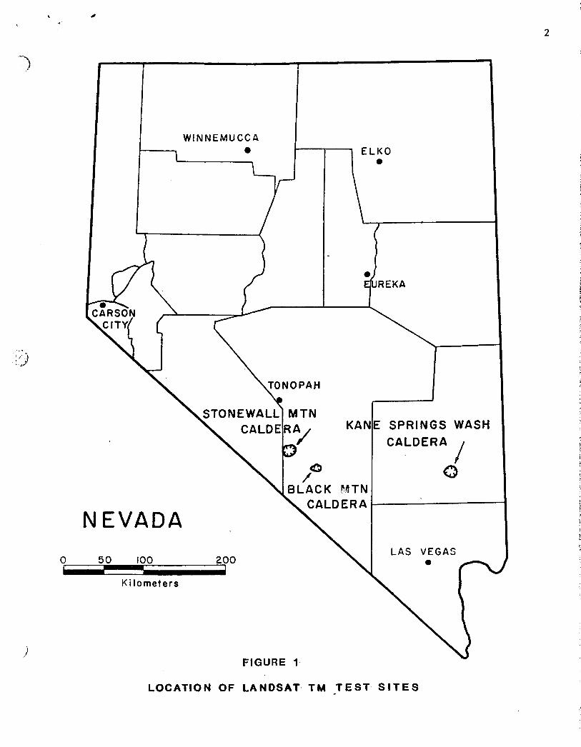
General Location Map ..................... 2
Location Map. Black Mountain and Stonewall Mountain Areas ................ 4
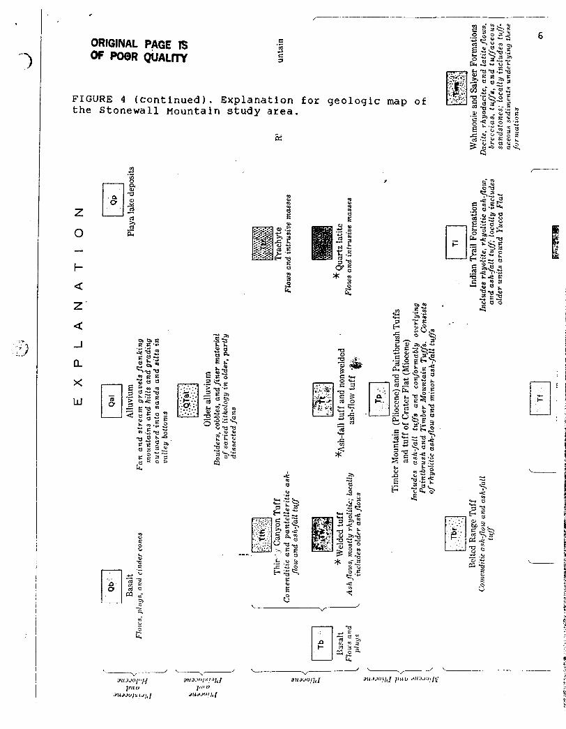
Geologic Map. Stonewall Area ............. 5 Geologic Map. Black Mountain ............. 7 Geologic Map. Kane Springs Wash .......... 9 Sample Location Map. Kane Springs Wash ... 10 Scene. Photo. Kane Springs Wash ......... 12 Scene. Photo. Kane Springs wash ......... 12 Photo of Trachyandesfte. Kane Springs .... 13 Photo of Hico Formation. Kane Springs .... 13 Photo of Vapor Phase zone Kane Springs .. 14 Photo of Glassy Tuff. Kane Springs ...... 14 Photo of Coatings on Dense Weld zone ... 16 Photo of Coatings on Vapor Phase zone .. 16 Photo of Coatings on Glassy Ash ......... 17 Photo of Coatings on Rhyolite ........... 17 Photo of Coatings on Basalt ............. 18 Band 5 Image. Kane Springs Wash ......... 20 ISH Image. Kane Springs Wash ............ 25 PC Image. Black Mountain ................ 28 Bands 3 5 7 Composite. Black Mtn ........ 28 ISH Image. Stonewall Mountain ........... 30 3/1 5/7 4 composite. Stonewall Mtn ....... 30
Location Map. Kane Springs Wash ........... 3
Photo of Coatings on Gold Flat Fm ....... 18 PC Image. Kane Springs Wash ............. 22
1
INTRODUCTION
. -_ I .9
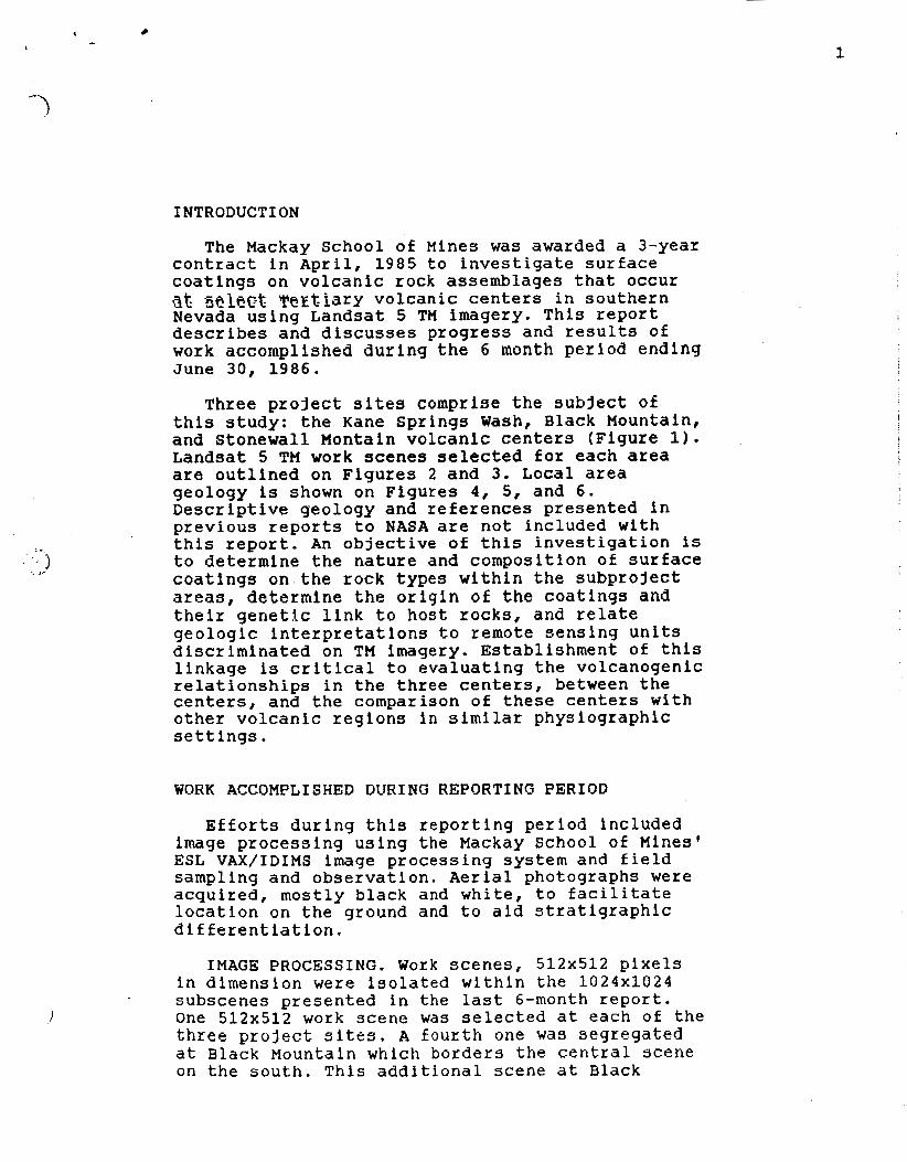
The Mackay School of Mines was awarded a 3-year contract in April, 1985 to investigate surface coatings on volcanic rock assemblages that occur at. select Tertiary volcanic centers in southern Nevada using Landsat 5 TM imagery. This report describes and discusses progress and results of work accomplished during the 6 month period ending June 30, 1986.
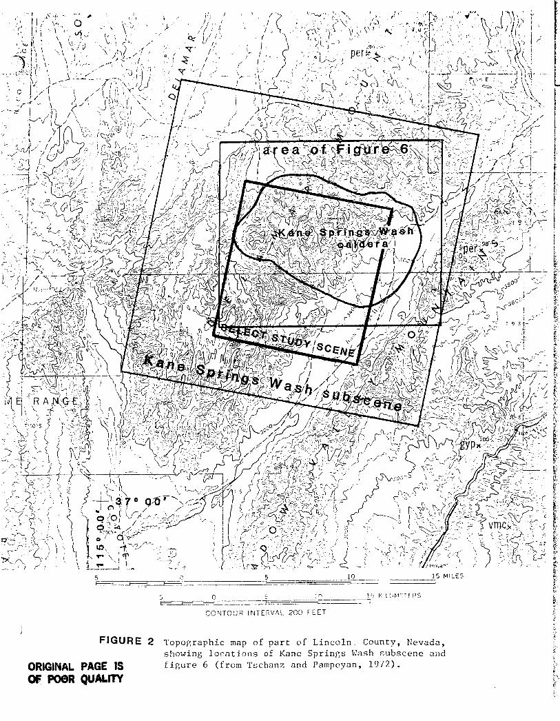
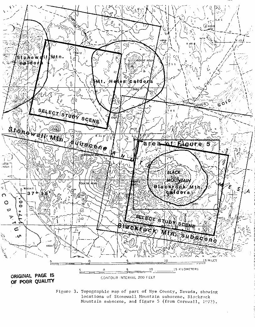
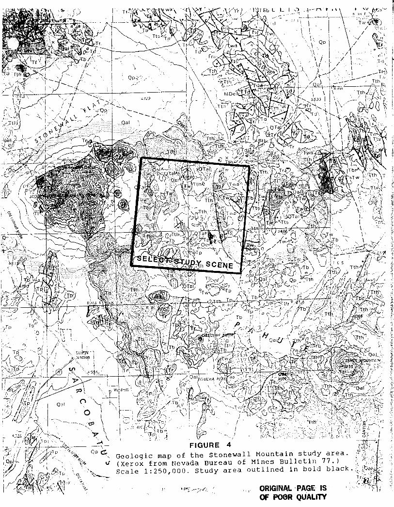
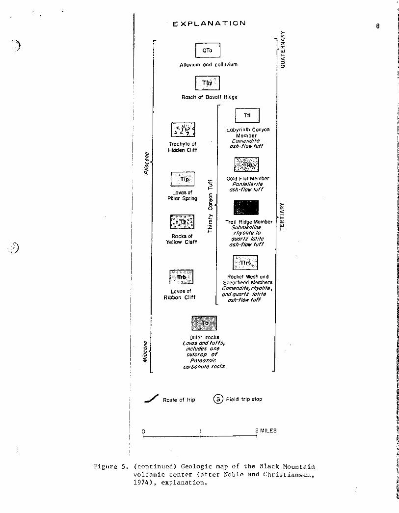
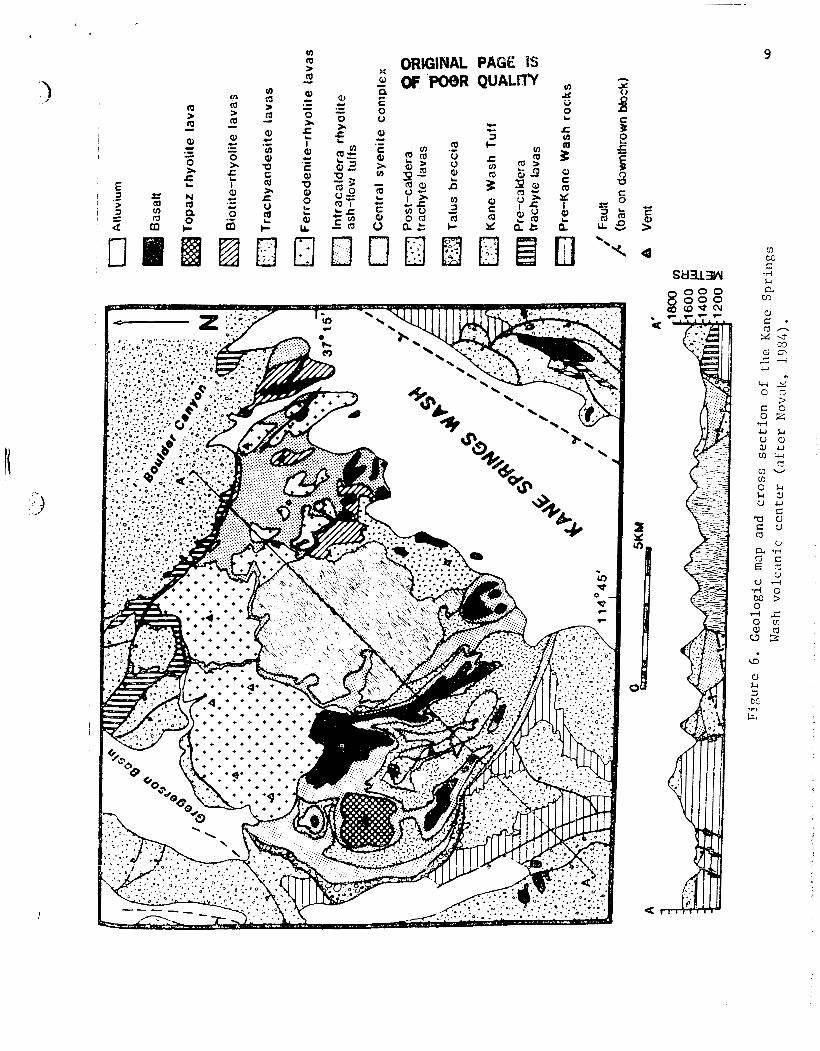
Three project sites comprise the subject of this study: the Kane Springs Wash, Black Mountain, and Stonewall Montain volcanic centers (Figure 1). Landsat 5 TM work scenes selected for each area are outlined on Figures 2 and 3 . Local area geology is shown on Figures 4, 5, and 6. Descriptive geology and references presented in previous reports to NASA are not included with this report. An objective of this investigation is to determine the nature and composition of surface coatings on the rock types within the subproject areas, determine the origin of the coatings and their genetic link to host rocks, and relate geologic interpretations to remote sensing units discriminated on TM imagery. Establishment of this linkage is critical to evaluating the volcanogenic relationships in the three centers, between the centers, and the comparison of these centers with other volcanic regions in similar physiographic set t ings .
WORK ACCOMPLISHED DURING REPORTING PERIOD
Efforts during this reporting period included image processing using the Mackay School of Mines' ESL VAX/IDIMS image processing system and field sampling and observation. Aerial photographs were acquired, mostly black and white, to facilitate location on the ground and to aid stratigraphic differentiation.
IMAGE PROCESSING. Work scenes, 512x512 pixels in dimension were isolated within the 1024x1024 subscenes presented in the last 6-month report. One 512x512 work scene was selected at each of the three p r o j e c t sites. A fourth one w a s Yegregated at B l a c k Mountain which borders the cent ra l Scene on the south. This additional scene at Black
~~~
WINNEMUCCA 0
€3 B L A C K FITN
CALDERA
LAS V E G A S
LOCATION OF FIGURE L A N D S A T 'J 1 T M T E S T S I T E S
0
€3 B L A C K FITN
CALDERA
LAS V E G A S
FIGURE 1
NEVADA
0 200 '-lrl Ki lometers
KAN~E SPRINGS WASH
I / CALDERA
LOCATION OF L A N D S A T T M T E S T S I T E S
10 15 MILES -- - 3 ____ ___ ---- - _. - 5 - - - ~
r, J :" m=------T. - - -
______ -
CCNTOUR I N T E R V A L 203 FEET
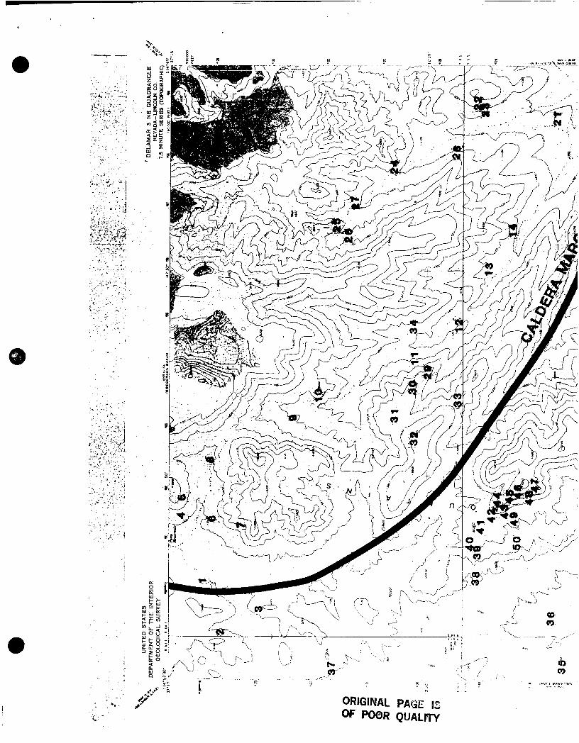
I FIGURE 2 T o p o g r a p h i c map o f p a r t of L i n c o l n . County , Nevada,
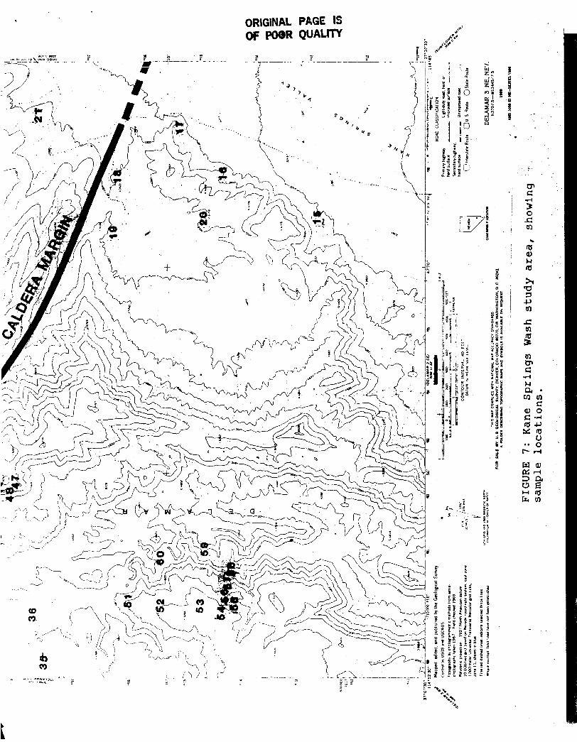
s h o w i n g l o c a t i o n s of Kanc S p r i n g s bJash s u b s c e n e aiid ORIGINAL PAGE IS f i g u r e 6 ( f rom Tschanz and Pampcyan, 1 9 7 2 ) .
OF P08R QUALrrV
15 MILES -. 10 -1 -.___
5 0 5 - J
‘p .~ _..- 15 KILOMETERS - - 5
ORIGINAL PAGE IS OF POOR QUALm
F i g u r e 3 .
CONTOUR INTERVAL 2CO FEET
T o p o g r a p h i c map of p a r t of Nye Coun ty , Nevada, showing l o c a t i o n s of S t o n e w a l l Mounta in s u b s c e n e , B l n r k r o c k Mounta in s u b s c e n e , and f i g u r e 5 ( f r o m Cornwall, l ( ’ 7 2 ) .
c
ORIGINAL PAGE IS OF PO@R QuALW
3 .- M! % c
Ld Z
3 0 a c
- I-
6
Z 6 1
a x W
00 LO
i 5 t
m Q)
3 .&. 3
* g$ G.4
V
i

I
j
I
i
,
i ,
j
i I I
1
I i I I
I I
I i I 1
I I
I
I I
I I I
I
i
I I I I
E % P L A N A T I O N
I 1 OTa j Alluvium arid colluvium
Basalt of Basalt Ridge r
Trachyte of Hidden Cliff
Pillar Spring
Rocks of Yellow Cleft
Lovas of Ribbon Cliff
Labyrinth Canyon Member
Comendi f e asbsh-flow tuff
~ 1 Gold Flat Member Pan fe//erite
i asb-flow tuff
c 2 .- r t-
Trail Ridge Member Su&a/ka/ine rhyo/;te to
quartz /dite ashflow tuff
Rocket Wash and Spearhead Members Comendite, rhyolite, and quartz /utite
ash-flow tuff
Older rocks Lovas ond tuffs,
includes one outcrop o f
Paleozoic carbonate rocks
Route of trip @ Field trip stop
I 2 MILES I I i
Figure 5. (continued) Geologic map of the Black Mountain volcanic center (after Noble and Christiansen, 1974), explanation.
M ORffiINAL PAGE IS 2 P OF POOR QUALlYf E 0 u
f
00 0 0 0 0 H
U
a
9
c. C
b
... . . , - . , . . . . I .
. . . . . . . b
. . .-
. I
. .
I
11
Mountain should provide advantages fox studying ashflow sheet stratigraphy from the Black Mountain caldera.
As a matter of routine, the following images wete produced f o r each of the 4 w o r k scenes:
INDIVIDUAL BANDS: 1, 2, 3, 4, 5, 7 BAND RATIOS: 4/3, 5/1, 5/2, 5/7, 3/1, 3/2 COLOR COMPOSITES: 3 2 1, 3 5 7, 3/1 5/7 4,
ISH: 3 5 7, 3/1 5/7 4 , 1 3 5 PRINCIPAL COMPONENTS: Individual PC's 1-6,
3/1 5/2 5 /7
Color composites 1 2 3,2 3 4,3 4 5
All images were contrast enhanced, chiefly by scaling with a 0.5% truncation at both high and low ends of the brightness ranges. PC images were scaled at a 0.2% truncation. other image renditions were computed, but those listed above were the ones routinely processed and photographed for comparison and field use. A few select prints from each area were enlarged to 8x10 inch to facilitate resolution, field location, and topographic registration.
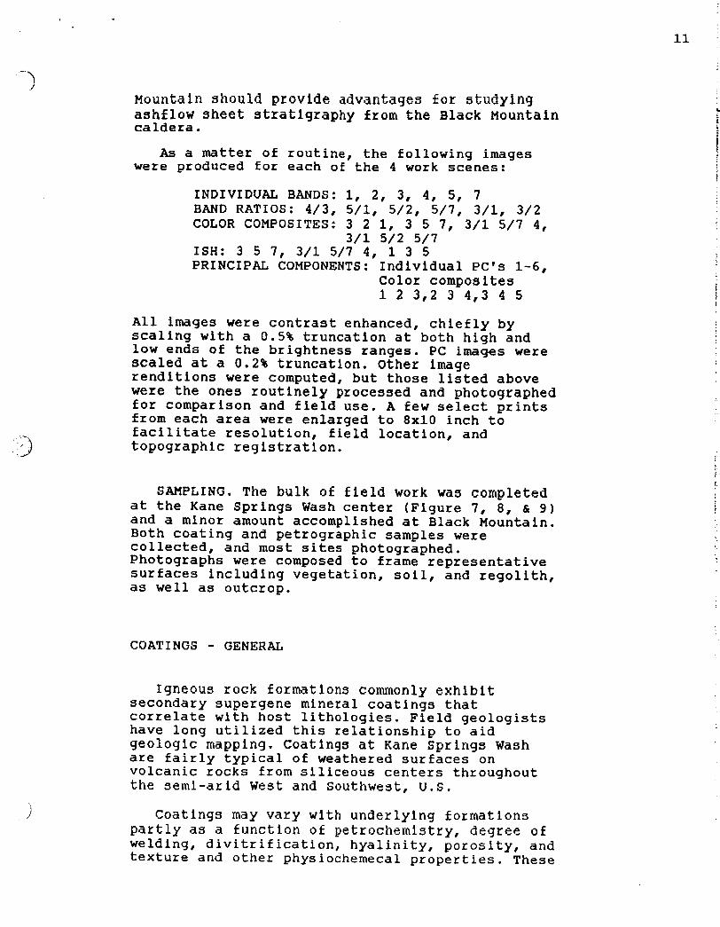
SAMPLING. The bulk of field work was completed at the Kane Springs Wash center (Figure 7, 8, 6 9) and a minor amount accomplished at Black Mountain. Both coating and petrographic samples were collected, and most sites photographed. Photographs were composed to frame representative surfaces including vegetation, soil, and regolith, as well as outcrop.
i
i 7
COATINGS - GENERAL
Igneous rock formations CokWonly exhibit secondary supergene mineral coatings that correlate with host lithologies. Field geologists have long utilized this relationship to aid geologic mapping. coatings at Kane Springs Wash are fairly typical of weathered surfaces on volcanic rocks from siliceous centers throughout the semi-arid West and Southwest, U.S.
Coatings may vary with underlying formations partly as a function of petrochemistry, degree of welding, divitrification, hyalinity, porosity, and texture and o t h e r physiochemecal properties. These
F I G U R E 8 . Kane S p r i n g s Wash v o l c a n i c c e n t e r . P h o t o t a k e n w i t h i n c a l d e r a l o o k i n g N W . T a - t r a c h y a n d e s i t e . Tt - a i r and a s h f l o w t u f f . T r - r h y o l i t e f l o w dome complex . Tb - l a t e b a s a l t .
t a k e n f rom w e s t b o r d e r of s t u d y area looking E . Th - Hico F o r m a t i o n ( a s h f l o w t u f f ) . KWo - member o of t h e Kane Wash F o r m a t i o n ( a s h f l o w s h e e t s of t h e Kane Wash caldera!. KWw - m e m b e r w o f t h e Kane Wash F o r m a t i o n . KWvl - member vl of t h e Kane Wash F o r m a t i o n .
f ,
ORIGINAL PAGE IS OF WR W A L ~
ORIGINAL PAGE IS OF POOR QUALITY
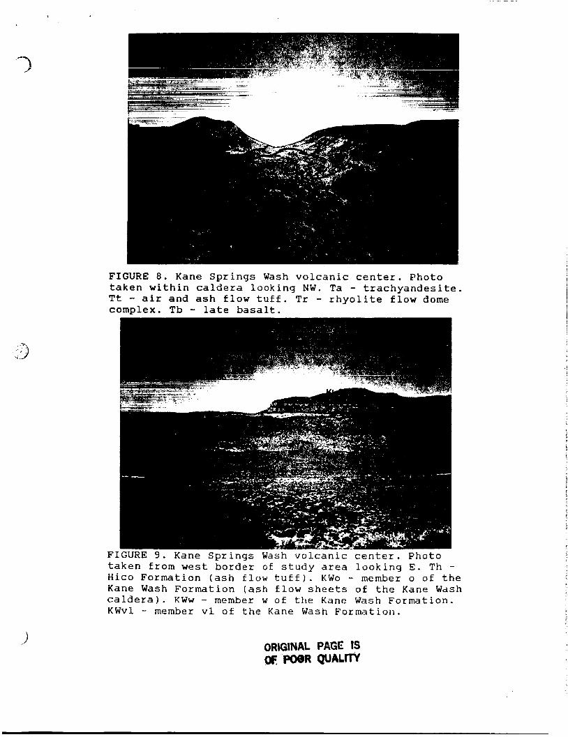
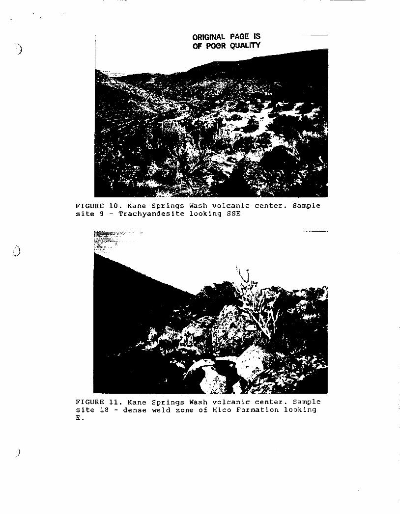
FIGURE 10. Kane Springs Wash volcanic center. Sample site 9 - Trachyandesite looking SSE
FIGURE 11. Kane Springs Wash volcanic center. Sample site 18 - dense weld zone of Hico Formation looking E.
ORGINAL PAGE 15 N POOR QUALm
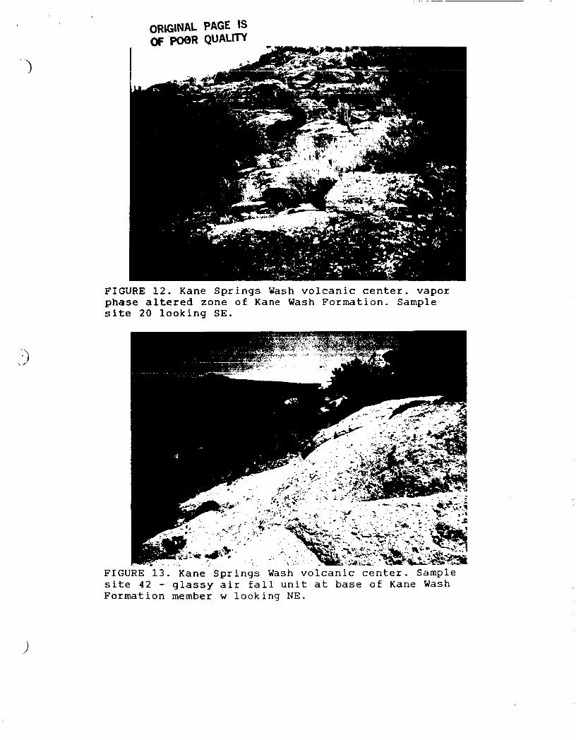
F I G U R E 12. Kane S p r i n g s Wash v o l c a n i c c e n t e r . vapor p h a s e a l t e r e d zone o f Kane Wash F o r m a t i o n . Sample s i t e 20 l o o k i n g SE.
F I G U R E 13 . Kane S p r i n g s Wash v o l c a n i c c e n t e r . Sample s i t e 4 2 - g l a s s y a i r f a l l u n i t a t base of Kane Wash F o r m a t i o n member w l o o k i n g NE.
features may vary consistently enough from one formation to another that map units can be differentiated inferentialy from their mineral coatings. One of the objectives of this investigation is t o determine the mineral and chemical composition of the coatings, relate coatings to host rock llthologies, and discriminate units on the basis of imagery characteristics. Application of imagery results to other areas, particularly unmapped volcanic terrains is one of the ultimate aims of this study.
15
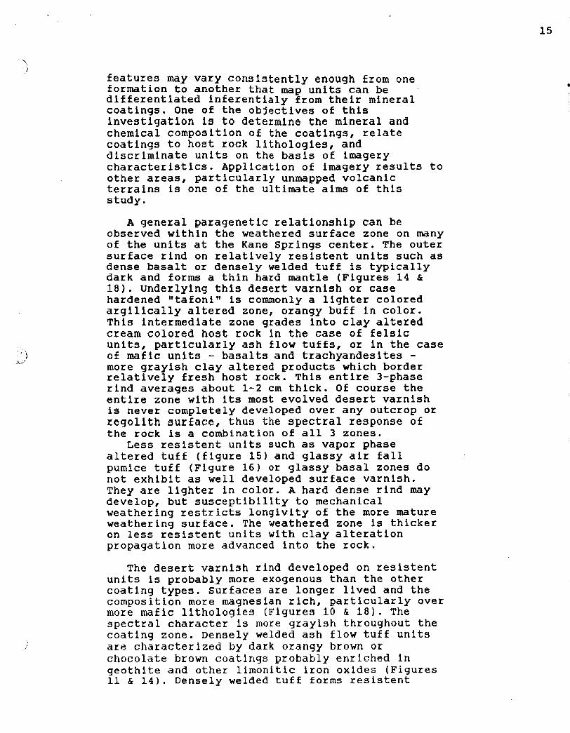
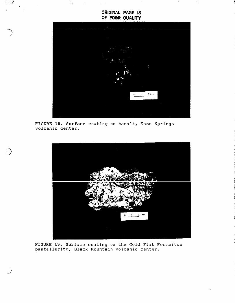
A general paragenetic relationship can be observed within the weathered surface zone on many of the units at the Kane Springs center. The outer surface rind on relatively resistent units such as dense basalt or densely welded tuff is typically dark and forms a thin hard mantle (Figures 14 6 18). Underlying this desert varnish or case hardened "tafonitt is commonly a lighter colored argilically altered zone, orangy buff in color. This intermediate zone grades into clay altered cream colored host rock in the case of felsic units, particularly ash flow tuffs, or in the case of mafic units - basalts and trachyandesites - more grayish clay altered products which border relatively fresh host rock. This entire 3-phase rind averages about 1-2 cm thick. Of course the entire zone with its most evolved desert varnish is never completely developed over any outcrop OK regolith surface, thus the spectral response of the rock is a combination of all 3 zones.
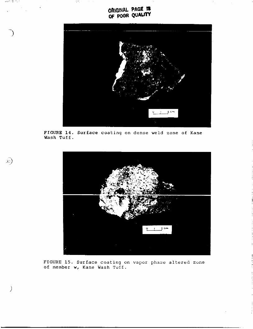
Less resistent units such as vapor phase altered tuff (figure 15) and glassy air fall pumice tuff (Figure 16) or glassy basal zones do not exhibit as well developed surface varnish. They are lighter in color. A hard dense rind may develop, but susceptibility to mechanical weathering restricts longivity of the more mature weathering surface. The weathered zone is thicker on less resistent units with clay alteration propagation more advanced into the rock.
The desert varnish rind developed on resistent units is probably more exogenous than the other coating types. surfaces are longer lived and the composition more magnesian rich, particularly over more mafic lithologies (Figures 10 €i 18). The spectral character is more grayish throughout the coating zone. Densely welded ash flow tuff units are characterized by dark orangy brown o r chocolate brown coat1ngY probably enriched l n geothite and other limonitic iron oxides (Figures 11 & 14). Densely welded tuff forms resistent
ORIGINAL PAGE t8 OF POOR warn
FIGURE 14. Surface c o a t i n g on d e n s e w e l d z o n e of Kane Wash Tuff.
-. .it.)
FIGURE 15. Surface c o a t i n g on vapor phase altered zone of member w, Kane Wash T u f f .
.-,,
ORIGINAL PpGE IS OF POOR QUALm
FIGURE 16. Surface coating on glassy ash a t base of member vl, Kane Wash Formation
F I G U R E 1 7 . S u r f a c e c o a t i n g or1 rhyolite flow unit, Kane Springs Wash volcanic c e n t e r .
6WiGlNAL PAGE IS OF POOR QUALW
FIGURE 18. Surface coating on basalt, Kane Springs volcanic center.
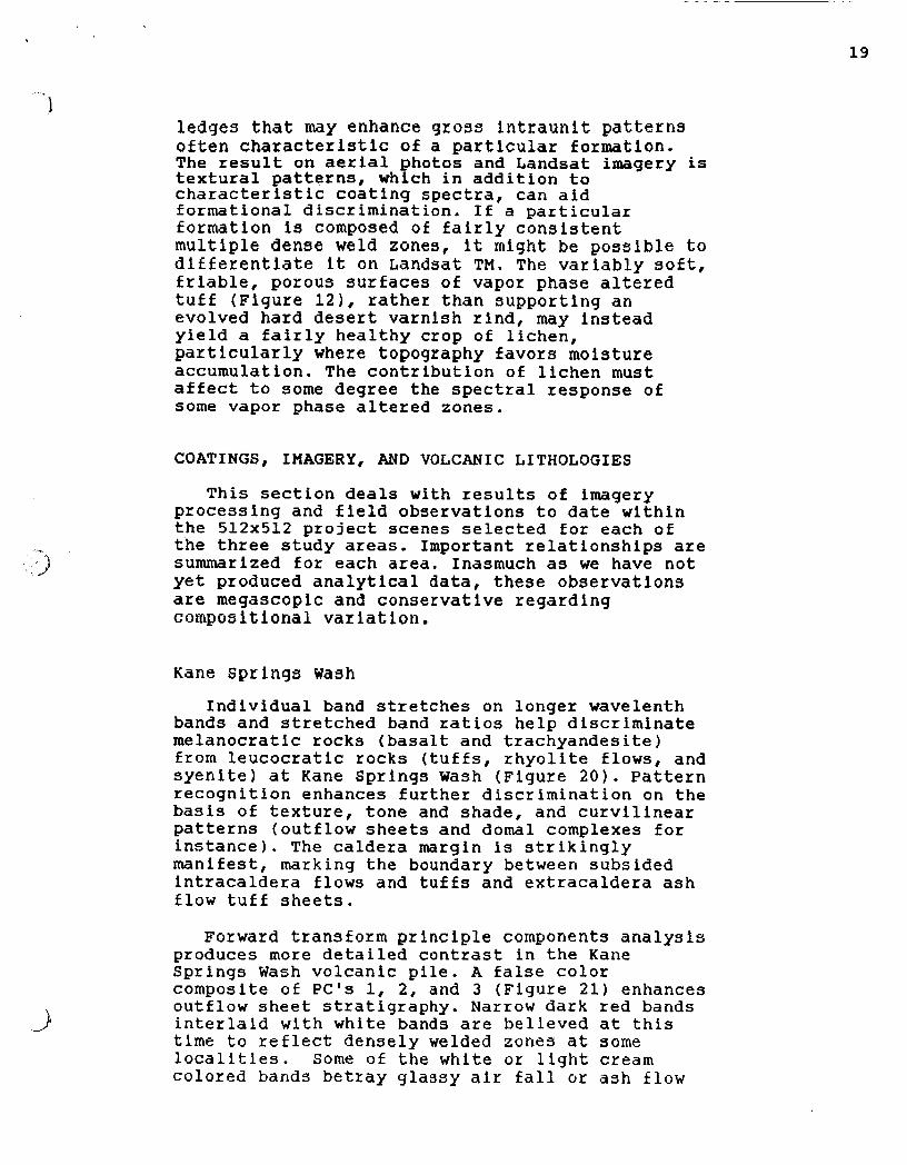
FIGURE 19. Surface coating on the Gold F l a t Formaiton pantellerite, B l a c k Mountain volcanic center.
19
I ledges that may enhance gross intraunit patter!is often characteristic of a particular formation. The result on aerial photos and Landsat imagery is textural patterns, which in addition to characteristic coating spectra, can aid formational discrimination. If a particular formation is composed of fairly consistent multiple dense weld zones, it might be possible to differentiate it on Landsat TM. The variably soft, friable, porous surfaces of vapor phase altered tuff (Figure 121, rather than supporting an evolved hard desert varnish rind, may instead yield a fairly healthy crop of lichen, particularly where topography favors moisture accumulation. The contribution of lichen must affect to some degree the spectral response of some vapor phase altered zones.
COATINGS, IMAGERY, AND VOLCANIC LITHOLOGIES
This section deals with results of imagery processing and field observations to date within the 512x512 project scenes selected for each of the three study areas. Important relationships are summarized for each area. Inasmuch as we have not yet produced analytical data, these observations are megascopic and conservative regarding compos i t i ona 1 var i a t ion
Kane Springs wash Individual band stretches on longer wavelenth
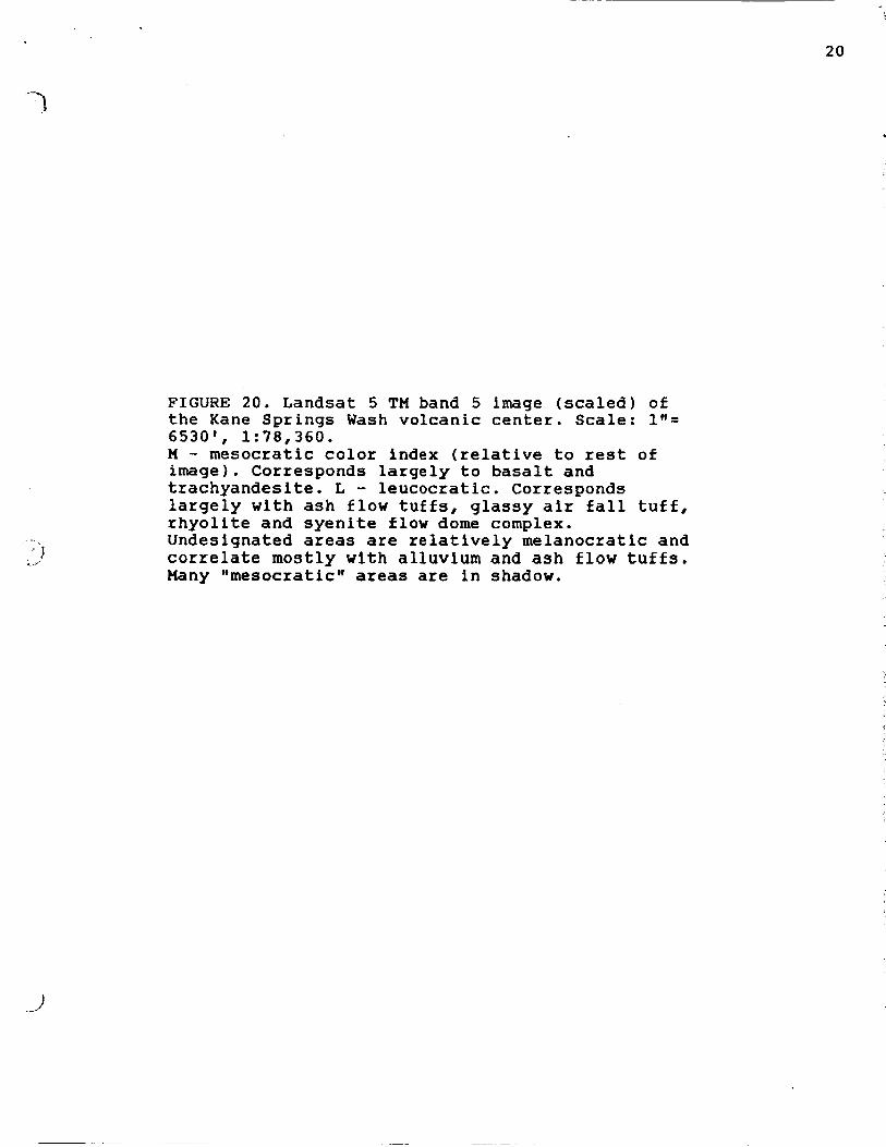
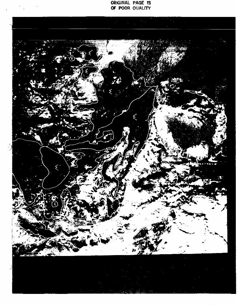
bands and stretched band ratios help discriminate melanocratic rocks (basalt and trachyandesite) from leucocratic rocks (tuffs, rhyolite flows, and syenite) at Kane Springs Wash (Figure 20). Pattern recognition enhances further discrimination on the basis of texture, tone and shade, and curvilinear patterns (outflow sheets and domal complexes for instance). The caldera margin is strikingly manifest, marking the boundary between subsided intracaldera flows and tuffs and extracaldera ash flow tuff sheets.
Forward transform principle components analysis produces more detailed contrast in the Kane Springs Wash volcanic pile. A false color composite of PC's 1, 2, and 3 (Figure 21) enhances outflow sheet stratigraphy. Narrow dark red bands interlaid with white bands are believed at this time to reflect densely welded zones at some localities. Some of t h e white o r light cream colored bands betray glassy air fall o r ash flow
20
FIGURE 20 . Landsa t 5 TM band 5 image ( s c a l e d ) of t h e Kane S p r i n g s Wash v o l c a n i c c e n t e r . S c a l e : 1"= 6530', 1:78,360. M - m e s o c r a t i c c o l o r index ( r e l a t i v e t o rest of image). Corresponds l a r g e l y t o basal t and t r a c h y a n d e s i t e . L - l e u c o c r a t i c . Corresponds l a r g e l y w i t h a s h f l o w t u f f s , g lassy a i r f a l l t u f f , r h y o l i t e and s y e n i t e f low dome complex. Undes igna ted areas are r e l a t i v e l y m e l a n o c r a t i c and c o r r e l a t e m o s t l y w i t h a l l u v i u m and a s h f l o w t u f f s . Many t 'mesocrat ic t ' areas are i n shadow.
~~
OWffiINAL PAGE IS OF POOR OUALITY
22
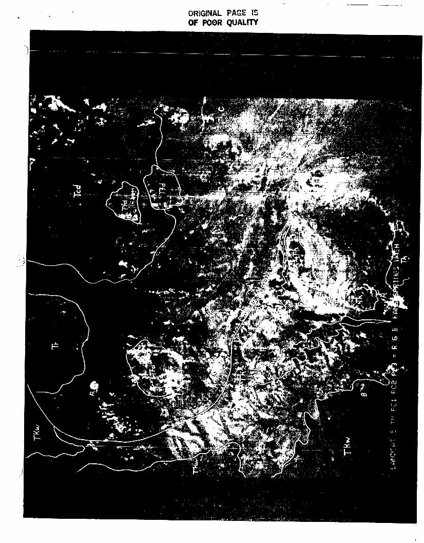
FIGURE 21: Landsat 5 TM principle components image (scaled) of the Kane Springs Wash volcanic center. PC*s 1, 2, and 3 are represented RGB, respectively. Scale:l*'= 6530, 1:78,360. Remote sensing units are interpreted on the basis of color and textural pattern. Westerly shadows are green as well as mafic volcanic assemblages. Tfd - rhyolite and syenite flow dome complex. Tkw - Kane Wash Tuff. Th - Hico Formation. Tcd - syenite cumulodome complex. T r - intracaldera rhyolite lavas. ' *An's - glassy air fall and ash flow deposits (white). * * B ' * * s - densely welded ash flow tuff zones (red bands) interbedded with vapor phase altered and glassy air fall tuff. Note red dominated alluvial fan at r*C*l which represents the relatively reflectant detritus from the syenite complex.
i
ORIGINAL PAGE IS OF POOR QUALm
2 4
interformational deposits, a relationship important to formational differentiation in volcanic terrain. Some light cream colored bands on Figure 21 appear to correlate with glassy air fall units at the base of Kane Wash ash flow tuff members V2 and W respectively. The "busyto red stripped pattern is coincident with the Hico Formation. This signature, a result of alternating densely weld and vapor phase altered interbeds, could be applied at least at this locale to formation discrimination. A stretched PC3 image provided sharp contrast between some glassy pumiceous ash flows and their nonglassy neighbors. variance (reflectance) is much more pronounced on eastern slopes than on western ones due to the morning illumination of Landsat 5 and resulting broader reflecting surfaces, the latter of which provides more favorable spectral response since distinctive units are commonly 10-30 feet thick, placing considerable strain on the discriminating ability of the 28.5m footprint of Landsat 5.
A stretched ISH image on bands 1, 3, and 5 is presented in Figure 2 2 . White glassy deposits and relatively felsic units are red (intensity) grading to yellow. Again, as with PC's intensity and saturation are greater on eastern sunward slopes.
Stretched 5/7 and 3/1 images produce indistinct tonal contrast with diffuse boundaries, except over rhyolite flow dome deposits (Figure 17) which stand out in dark contrast to surrounding units on the 5/7 image, indicating less hydrous mineral components. On the 3/1 image the more mafic basalt and trachyandesite lava appear somewhat darker than the felsic deposits.
Influence of Vegetation (from 4 /3 ratio images) does not appear to be serious except for the northern part of the scene and two other irregular high altitude zones. Growth on subhorizontal and gentle slopes consists predominately of sagebrush, foxtails, and other grasses. High elevation growth, so conspicuous on the 4/3 image, is characterized by juniper trees and shrub plants. The greenish orange dedrltic pattern in the SE portion of Figure 21 is vegetation produced (sage brush, yucca, cholla, broom grass, and other low growth). Some of the relatively light bands which colncide with glassy deposits and vapor phase altered tuff tend t o he slope formers, flanked both below and above by dense weld ledge forming ash flow units. These more porous friable units often host distictive floral populations,
. 25
FIGURE 22: Landsat 5 TM ISH false color composite (scaled) of the Kane Springs Wash volcanic center. ISH function performed on bands 1, 3, and 5. Scale: 1"= 6530', 1:78,360. Remote sensing units are consistent with those shown on Figure 21. Note that the white glassy ash and tuff deposits are red (intensity), and that dark basaltic assemblages and shadows are blue (hue).
P
ORIGINAL PAGE OF P08R Qum
, *
--)
27
i n c l u d i n g g r e a t e r d e n s i t y of Ycrub juniper, josuha trees, f o x t a i l grass, and l i c h e n . '
B l a c k Mountain
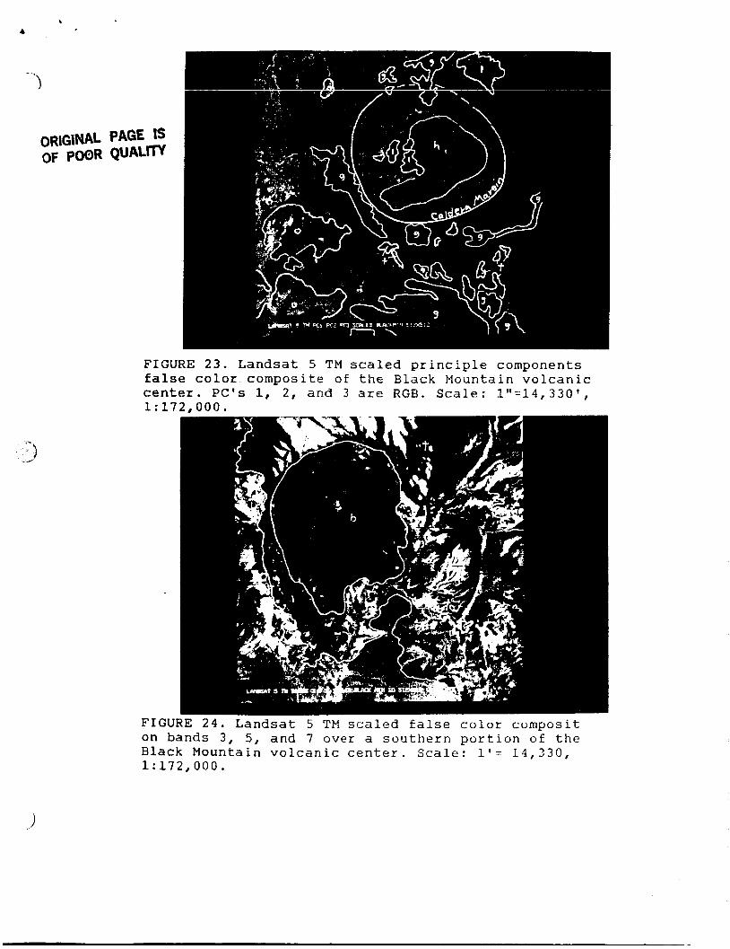
F i g u r e 1 9 shows c o a t i n g s on t h e Gold F l a t member of t h e T h i r s t y Canyon T u f f , a n o u t f l o w d e p o s i t f rom t h e B l a c k Mountain caldera. The Gold F l a t member is a p a n t e l l e r i t e ( i r o n enr iched p e r a l k a l i n e a s h f l o w ) , and forms a t h i n c a p ove r much of t h e mesa t e r r a i n s o u t h of B l a c k Mountain summit. I t e x h i b i t s i n s h a r p c o n t r a s t t o s u r r o u n d i n g u n i t s on ISH, PC ( F i g u r e 231, and f a l s e c o l o r compos i t s such as a 3, 5, 7 s t r e t c h ( F i g u r e 24). Other u n i t s , i n c l u d i n g t h e L a b y r i n t h Canyon t u f f , t h e T ra i l Ridge T u f f , and t h e c e n t r a l caldera t r a c h y t e , a l s o respond w i t h character is t ic imagery i n TM band p r o c e s s i n g .
A second s t u d y s c e n e (Figure 2 4 ) was s e l e c t e d a t B l a c k Mountain t o p rov ide an area more conducive t o t h e s t u d y of s t r a t i g r a p h i c r e l a t i o n s h i p s between m u l t i p l e a s h f l o w c o o l i n g u n i t s . E f f o r t s w i l l focus w i t h i n t h e NE q u a d r a n t of t h i s scene.
The 512x512 s tudy scene s e l e c t e d f o r t h e S t o n e w a l l Mountain v o l c a n i c center (F igures 25 & 2 6 ) st raddles t h e w e s t e r n margin of t h e Mount Helen caldera and t h e e a s t e r n p a l e o r i m of t h e S tonewa l l Mountain c a l d e r a . The s c e n e encompases d i v e r s e P l i o c e n e v o l c a n i c r o c k s i n c l u d i n g t h e S tonewa l l Mountain Tuff ( i n c l u d e d w i t h t h e T h i r s t y Canyon Tuff by o r i g i n a l mappers, b u t r e d e s i g n a t e d i n 1984.)
Image p r o c e s s i n g resulted i n d i s t i n c t i v e f a l se c o l o r c o n t r a s t c o r r e l a t i n g w i t h l i t h o l o g i c p r o p e r t i e s . Scaled 3/1, 5/7, 4 and ISH images (Figures 25 8 26) h i g h l i g h t t h e T h i r s t y Canyon T u f f and o t h e r u n i t s as wel l . A major N-S normal f a u l t , p a r t of t h e M t . Helen caldera margin, l o c a t e d east-central i n t h e work s c e n e , e x h i b i t s a s a s t r i k i n g c u r v i l i n e a r i n t hese e n h a n c e m e n t s . More s u b t l e v a r i a t i o n s were d i s p l a y e d by a PC 1 2 3 f a l se c o l o r compos i t e .
SCHEDULE FOR NEXT REPORTING P E R I O D
Sampling is c o n t i n u i n g at this t i m e a t the
2 8
FIGURE 23. Explanation for remote sensing units shown on following figure.
o - older rocks, mostly silicic volcanics t - Trail Ridge member of Thirsty Canyon Tuff g - Gold Flat member of Thirsty Canyon Tuff 1 - Labyrinth Canyon Tuff h - Trachyte of Hidden Cliff
FIGURE 24. Explanation for remote sensing Units shown on following figure.
tc - Thirsty Canyon Tuff outflow sheets of the Black Mountain caldera. Distinct blue image is Gold Flat Tuff
b - late basalt
8
s
OR1 OF
IGINAL POOR
PAGE QUAI
I IS .m
FIGURE 23. Landsat 5 TM scaled principle components f a l s e color composite of t h e B l a c k Mountain volcanic center. PC's 1, 2, and 3 are RGB. Scale: 1"=14,3301, 1: 172.000.
... :;,)
FIGURE 24. Landsat 5 TM scaled f a l s e c o l o r composit on bands 3, 5, and 7 over a southern portion of the Black Mountain volcanic center. Scale: I-'= 14,330, 1:172,000.
b
FIGURE 25. Explanation for remote sensing Units shown on following figure.
30
0 - Paleozoic quartzite S - Stonewall Mountain Tuff. Light moss
green portions reflect Civet Cat Canyon member
B - Basalt f - chiefly alluvial deposits (include some
o u t c r o p ) derived from fine f e l s i c quartz porphyry flows probably from the Mt. Helen caldera
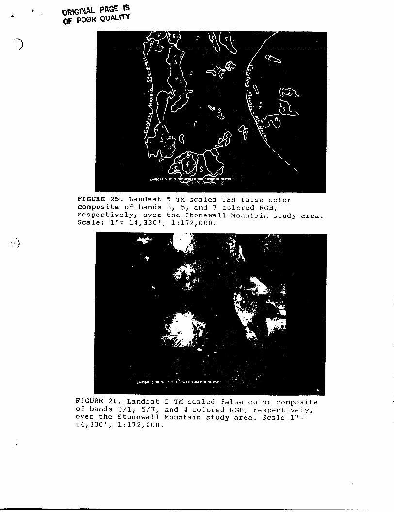
F I G U R E 2 5 . L a n d s a t 5 TM s c a l e d ISH f a l s e c o l o r c o m p o s i t e of bands 3 , 5, and 7 colored RCB, r e s p e c t i v e l y , over the S t o n e w a l l Mountain s t u d y area. Scale: I t = 14,330', 1:172,000.
F I G U R E 2 6 . L a n d s a t 5 TM scaled f a l s e c o l o r composite of bands 3/1, 5/7, and 4 colored RGB, respectively, over t h e S t o n e w a l l Mountain s t u d y area. Scale 1"= 14,330' , 1:172,000.
c @
32
Black Mountain and Stonewall Mountain project areas. Inasmuch as the Stonewall Mountain work scene is within the Air Force Gunnery Range, access is restricted to select weekends and subject to tight security and supervision by Nellis Alr Force Base personnel. Petrographic thin section samples are being prepared to show relationship of coatings to host rock. Analytical techniques primarily involving XRD and XRF will be the thrust of our efforts during this coming Fall. Image enhancement and processing experiments will continue as well. A more detailed review and correlation of specific formations, coatings, vegitaiton, and other site complexities and imagery characteristics is also in progress.