the proceedings of a seminar on the...
TRANSCRIPT

REPUBLIC OF BOTSWANA
(Director: T.P. Machacha)
Bulletin Series
BULLETIN 29
THE PROCEEDINGS OF A SEMINAR ON THE
MINERAL EXPLORATION OF THE KALAHARI
OCTOBER, 1983
Edited by
D.G. HUTCHINS
A.P.LYNAM
1.9fiiY' l q '6"5,
Published by the Director, Geological Survey Department Private Bag 14, Lobatse, Botswana
with the authority of the Ministry of Mineral Resources and Water Affairs
Republic of Botswana
Price: PIO,OO
PRINTED BY THE GOVERNMENT PRINTER, GABORONE.

ISOTOPE GEOHYDROLOGY: SOME HYDROCHEMICAL AND WATER SUPPLY INSIGHTS INTO THE KALAHARI
B.TH. VERHAGEN (Nuclear Physics Research Unit, University of
the Wi twatersrand, Johannesburg)
INTRODUCTION
Duri ng the past 15 years, envi ronmental isotope techni ques have been employed in studies of ground waters in the Kalahari. These studies have produced some new i nsi ghts into the geohydrology of the Kalahari whi ch has often defi ed the "classi cal" methods of i nvesti gati on. Thi s paper wi 11 attempt to gi ve an overvi ew of the results obtai ned, the methods of ; nterpreta ti on of the da ta a nd the overa 11 pi cture these/ data, in the view of the author, is presenting of the ground water of thi s regi on.
Ground water; s arguably the most important asset of the Kalahari. It has sustai ned human habi tati on from well before the advent of western technology (Livingstone, 1857) albeit on a sparse and low-demand level. More recently, wi th the advent of deep dri lli ng, more substanti a 1 supplies have been found and exploited for modern farming, larger villages or towns as well as for mi ni ng operati ons.
The general conclusion from earlier studies such as those of Passarge (1906), Frommurze (1953), Marti n (1961) and Boocock and van Straten (1961, 1962), has been that ground water supplies found in the Kalahari are the remnants of earlier, "pluvial" periods. Under present climatic condi ti ons no rai n recharge could occur under thi ck (Z6m) Kalahari sand cover, the total amount of infiltrated rain water being lost to evapotranspi rat; on. Thi s led further to the concepts that in much of the Kalahari ground water exploi tati on is essenti ally a mi ni ng operati on and that any present-day recharge can occur only in areas where pre-Kalahari format; ons are exposed when it would then reach areas of th; ck Kalahari cover by 1 a tera 1 underfl ow, duri ng wh; ch the water woul d become progressively more saline. More recently, studies have appeared which tend to conf; rm thi s model, such as Vogel and Bredenkamp (1969) and Foster et a1. (1982), the latter bei ng largely based on studi es of the unsaturated zone. In a recent analysi s, de Vri es (1984) postulates the decli ne of piezometric levels over the last 104 years, with effectively zero recharge. Since the application of environmental isotopes and more detai led apprai sal of the hydrochemi stry, a seri es of studi es have appeared which lead to an entirely different point of view, e.g. Verhagen et al. (1974), Mazor et al. (1974, 1977), Verhagen et .a1. (1979), Bath (1980), Mazor et a1. (1980) and Verhagen (1984).
ENVIRONMENTAL ISOTOPES SUITABLE FOR HYDROLOGICAL STUDIES
The appli cat; on of envi ronmental isotopes to ground water i nvesti gati ons has been extensi vely revi ewed, cf. Moser and Rauert (1980); IAEA (1983).
278
A br; ef resume is here g'i ven of the most commonly used isotopes, whl ch have also been employed in these studies.
a) Tritium (3H) Rad;oactive, half-life 12,3 years. Produced by cosm; crays in uppel' atrgsphere, ox; di zed and raj ned out at concentra t; ons of 1 .. 5xlO- w; th respect to hydrogen (1-5 T. U) • These concentrati ons increased 15 fold due to nuclear bomb fallout up to 1964 ; n the southern hemi sphere, and have si nce been dec1; n; ng to close to natura" levels. Allows for "dat; ng" of ground water up to several decades.
b) Radiocarbon (14C) Rad'ioactive, half-life 5730 years. Cosmic ,ray produced, enters carbon cycle as C02 at concentrati ons wi th respect to 12c at 10-12 or 100 pmc. Bound by photosynthes; s, C02 from decay; ng p'!ant materi al ; n so; 1 is d; ssolved by ; nfi 1 tra t; ng rai n wa tel" to form di ssol ved b; ca rbona tes contai n; ng 50-100 pmc. Allows for "dati n9" of ground water up to tens of thousands of years. Southern hemi sphere level s rose to 160 pmc ; n latter 60's due to bomb fallout and have since declined.
c) Ca rbon-1 r2 Stable isotope of ca rbon, conl~ntra ti on about 1,1% w.r.t. C. Depleted with respect to C;n organic pro-cesses, the concentration in dissolved HC03 depends on initial values indifferent plants and subsequent mi xi ng and exchange processes. Expressed as %0 (per mi 11 e) fracti ona 1 di fference from limestone standard.
d) Deuterium (2H) and oxygen _18( 180): At nominal isotopic concentrati ons of 0,015% and 0,2% respecti ve1y, these heavy isotopes are depleted in vapour rising from the oceans. Subsequent rainout causes further depletion naintaining a linear relationship, the so-called rai n li ne. Moi st, cool cond; ti ons enhance depleti on. Evaporati on from open water bodi es causes enri chment along a 1i ne of lesser slope (evaporation line). Given as %0 deviation from standard.
GROUND WATERS AT ORAPA
The systemati c study of the Kalahari basi n was ini tiated at Orapa, where the questi on of the vi abi li ty of, and recharge to, the Karoo aqui fers was to be investigated (Mazor et al., 1977). Below 1 - 17 metres of Ka 1 aha ri Beds cover the Stormbergseri es of the Ka roo system occurs, consi sti ng of up to 100 m. of basalts followed by up to 130 m. of sandstone, which is the major aquifer.
The pi ezometri c level of the deep Karoo aqui fer roughly co; nci des wi th the phreatic level in the I<alahari Beds. Short-term variations are observed in the latter: long tet'm declines during exploitation and restoration to beyond the original rest level are observed in the se\TIia rtesi an deeper aqui fer.
The shallow ~a1ahari !,eds waters, encountered in a well and a borehole, gave high 1 C and Ii values, the latter fluctuating over a three year peri od of observati on (Fi g. 1). The sandstone aqui fer produced
279

30 A. TU 25
20
15
10
5
TU B. 5
4-
3
2
1
6 • 10 12 2 4 6 • 10 12 4 6 1970 1971
Fi gure 1. Vari ati ons in triti um concentrati on inA. a hand-dug well and B. a borehole in the Kalahari Beds and shallow basalt at Orapa.
, , , , r r r r , r I I I , , t-
[±] 7
0 -36 t- o -
0 --38 x 0 -
- --40 0 x -• 0
"l? 6 • 6 -x 0 0 6 eo -42 t- 6 x 6 -0
f-6 -
0 0 x x -44 t- x -0
t- 6 0 0 --46r
6 -I r f I I I I I I I I I I I I
-7.2 -7.0 -6.8 -6.6 -6.4 -6.2 -6.0 -5.8
8 '6 0 %.
Fi gu re 2. Stable isotope composition of Orapa ground waters. Symbols denote: X - Ka 1 aha ri Beds; 0, o and [:" : - Sandstone aqui fer water from three well fields. See also Figure 8.
280
14C values in the range 9-20 pmc, wi th low to vani shi ng concontrations of 3H. As some of th.e tritium values were higher than could be expected to accompany the correspondi ng 14C concentrati ons it was assumed that the observabl e 3H was the resul t of rni xi ng wi th recent Kalahari Beds and basalt waters inside the boreholes themselves during abstracti on.
Corrections for the expected 14C concentrations which would have accompani ed such 3H inputs from recent water addi ti ons show that the in-situ water in the sandstone aquifer should have near-vani shi ng 14c concentrati ons, implyi ng very hi gh resi dence ti meso
The chemical composition of water in the three units (Kalahari Beds, basalt and sandstone) largely overlap. Simi larly, the stable isotope compositions (Fig. 2) lie in the same, fairly tight, cluster. (See also Fi g. 8 for acompari son wi th Gordoni a data.) It can therefore reasonably be assumed that the ground water encountered in the three uni ts forms a conti nuous system, whi ch was suggested by the pi ezometri c levels. The conditions of recharge, furthermore, appear to have been si rni 1 a r for the di fferent uni ts.
A traverse of boreholes was sampled from Orapa to Serowe in order to i nvesti gate the possi bi li ty of regi onal underflow towards Orapa from a presumed recharge area where the sandstone outcrops on the escarpment in the east. However, no chemical evolution could be established nor ageing on the radiocarbon time scale. Some of the 14C concentrations in the sandstone aquifer near Serowe were found to be as low as, or lower than, the i n-si tu values at Orapa.
The model that evolved from these observations is that rain recharge affects the whole hydrological system, which is essentially continuous, but that the deeper waters are effecti vely trapped and very slow movi ng, implying minimal net transport of shallow water through the joints and fi ssures of the confi ni ng (basalt) layer. The balanci ng mechani sm shoul d therefore be evapotranspi rati on from the shallow aquifers, the only "acti ve" part of the system. The corollary would be that exploi tation, which would lower the piezometric levels in all sections of the system, would lead to reduced losses and therefore enhance rai n recharge.
THE KALAHARI BASIN
The survey at Orapa was extended to other parts of the northern, as well as the western and southern Kalahari of Botswana. Thi s survey was conducted in three phases: an initial wide-ranging survey during 1971/72, an extensi on of thi s survey duri ng late 1974 and a further survey of the Karoo aqui fers in Kweneng duri ng 1978. The survey had, perforce, to be conducted mai nly on exi sti ng produci ng boreholes with, at best, a dri ller' s log as the only i nformati on avai lable.
The spread of sampli ng poi nts is shown in Fi gure 3, whi ch i ndi cates a fai r coverage of the more populated areas of the Kalahari, involving a variety of Kalahari Beds thicknesses of sand as well as the other units, and underlain by various combinations of Karoo rocks (with and· without Stormberg basalt cover), with Ghanzi beds in the north and Matsap rooks in the south.
281
Fi gure 3.
Figure 4.
ANGOLA
HOOo
IOO~?O" GI1ANZI
.2350
400
ZAMBIA
75(/ 300 200-900
<" tOBATsr
01300
Sprea d of sampling poi nts for stu1ies in ground water salinities gi yen in mg1- .
• TU
20 - • • •
15 f- .
• • • • •
10 • • • • 0
s- o o \ 0
0 0
o 0
0 o 0 0 .or • • .. •• II .~. •• • • • • 30 40 so 60 70 80 90 100 110 120
pmc
Tri ti um and ra di oca rbon concentra ti ons in waters (1971-1978).
282
Botswa na, wi th
Kalahari ground
Radiocarbon concentrati ons ranged from 1 - 132 pme and tr"i ti um COlleen" trati ons from 0 - 24TU. The relati onshi Ii is shown in Fi gure 4, showll1q the correspondi ng bui 1 d-up of the two radi oacti ve speci es. The obser'"" vati ons cover a number of years, resulti ng in differi ng i ni ti al concentra ti ons of the two speci es (see Secti on on Envi ronmenta 1 Isotopes). Vari ous combi nati ons are al so generated by di fferent recharge hi stori es and mi xtures between 01 der and younger waters. The overall pi cture presented, however, is one of wi despread contemporar'y water present in a va ri ety of aqui fers.
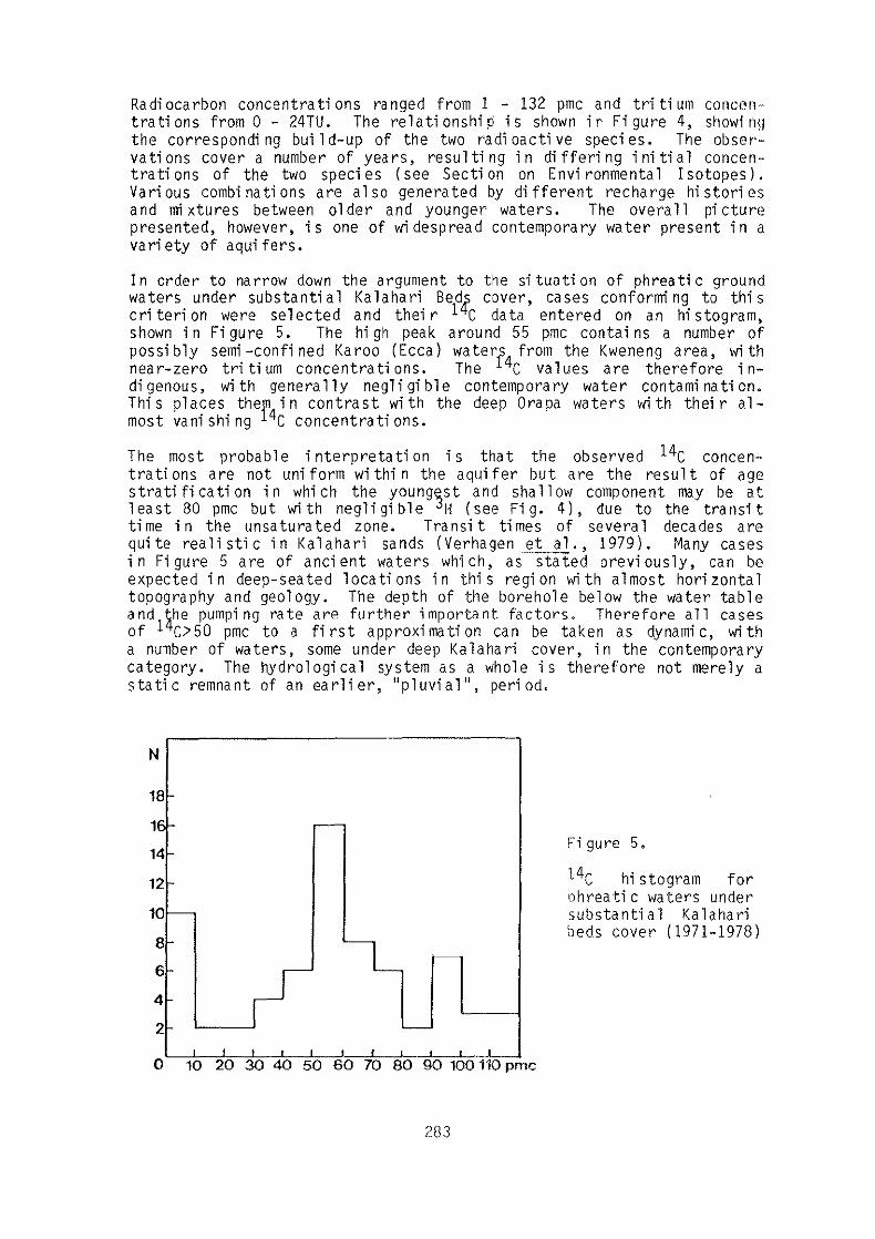
I n order to na rrow down the a rgument to the si tua ti on of phrea ti c ground waters under substantial Kalahari Beds cover, cases conforming to this cri teri on were selected and thei r 14C data entered on an hi stogram, shown in Figure 5. The high peak around 55 pme contains a number of possi bly semi -confi ned Karoo (Eeea) water[4 from the Kweneng area, wi th near-zero tritium concentrations. The C values are therefore indigenous, with generally negligible contemporary water contamination. Thi s places ther4 in contrast wi th the deep Orapa waters wi th thei r al-most vani shi ng C concentrati ons.
The most probable i nterpretati on is that the observed 14C concentrati ons are not uniform wi thi n the aquifer but are the result of age strati fi cati on in whi ch the young'3st and shallow component may be at least 80 pmc but with negligible H (see Fig. 4), due to the transit time in the unsaturated zone. Transit times of several decades are quite reali sti c in Kalahari sands (Verhagen et al., 1979). Many cases in Figure 5 are of ancient waters which, as stated previously, can be expected in deep-seated locations in this region lvith almost horizontal topography and geology. The depth of the borehole below the water table and the pumpi ng rate are further important factors. Therefore all cases of 14C>50 pmc to a first approximation can be taken as dynamic, with a number of waters, some under deep Kalahari cover, in the contemporary category. The hydrological system as a whole is therefore not merely a stati c remnant of an earli er, "pluvi al", peri od.
N
18:-
1E Co
14-
12r
10-
8
6-
4
2 '--
I 'I .1 ,
o 10 20 30 40 50 60 70 80 9{) 100 110 pmc
283
Fi gure 5.
14C hi stogram for !lhreati c waters under substantial Kalahari beds cover (1971-1978)
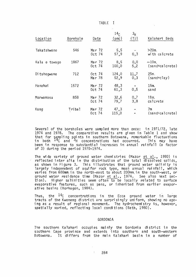
TABLE I
14C 3H Loca ti on Borehole Date (pmc) (TU) Ka 1 a ha ri Beds
Ta ka ts hwa ne 546 Mar 72 5,5 >20m. Oct 74 57,9 0,3 wi th ca 1 crete
Kala e tswago 1867 Mar 72 8,5 0,0 ~lOm_
Oct 74 100,0 5,2 (sand+ca 1 crete)
Oi ts hegwa ne 712 Oct 74 124,0 11 ,7 25m. Ma r 78 52,9 0,3 (sand+clay)
Ha nahai 1572 Mar 72 48,3 15m. Oct 74 61,3 0,5 sand
Morwamosu 858 Mar 72 32,6 0,7 11m. Oct 74 79,7 3,8 calcrete
Kang Tri ba 1 Mar 72 47,3 7m Oct 74 115,0 (sa nd+ca 1 crete)
Several of the boreholes were sampled more than once: in 1971/72, late 1974 and 1978. The comparative results are given in Table 1 and show that for sampli ng PQi nts in southern Botswana, remarkable fluctuati ons in both 14C and jH concentrati ons had occurred. Thi s may have been in response to substantial increases in annual rai nfall (a factor of 3) duri ng the peri od 1970-1974.
The wide variety of ground water chemistries (Mazor et a1., 1980) is reflected inter alia in the distribution of the total dissolved solids, as shown in Figure 3. This illustrates that ground water salinity is largely independent of aqui fer rock type, mean annual rai nfall, whi ch varies from 600mm.in the north-east to about 200mm. in the south-west, or ground water resi dence time (Mazor et al., 1974. See al so next section). Higher salinities seem oftentO°be locally related to surface eva pora ti ve fea tures, such as pa ns, or inherited from ea rl i er evaporati ve basi ns (Verhagen, 1984).
Thus, the 14C concentrati ons in the Ecca ground water in large tracts of the Kweneng di stri ct are surpri si ngly uni form, showi ng no ageing as a result of regional movement. The hydrochemistry is, however, spatially varied, reflecting local conditions (Bath, 1980).
GOROONIA
The southern Kalahari occupi es rnai nly the Gordoni a di stri ct in the southern Cape provi nce and extends into southern and south-western Botswana. It differs from the rnain Kalahari basin in a number of
284

N
00
e
n
Fi g
. 6
.
) '" ••
-S.
'S
-So!
;
J "0
" -
3.5
-4
.8
(;' '1 'm
5
45
-3
.4
90
-2
.9
-5.0
_
4.2
,.'
-¥ 111
, ,
}(-
12
,,¥13
o
1
c
17
:20
'r ..
.. _
9.1
_
4.3
-3
." -3
.1
1""
. - -1$
.' -
".5
~"'. "
-6.2
-4
.3
......
..
os I'"
'" -.. ,
'-0
-4
.J
Fig
ure
6
8"
" ,"
., l '" '(
--1
: _
4.1
'" "
_0
.1
_4
.1
So
uth
A
frIc
a
". ~
""" ..
1 7
'.
JJ
-5.7
_
'.9
-5
.6
_5
.6
LE
GE
ND
I ~l C
ON
DU
CT
IVIT
Y
(m5
jmj
"e
C
ON
e. (I
"MC
)OI!
'H C
ON
e. fl
U)
"c (
ON
e. (6%~PO!l)
"0
CO
Ne
. !0
9f.
"SM
OW
)
SC
AL
E
• , 1
0
15
2
0
23
KM
1
'-===
---:
,.'
If.
" ,._'
W
, -7
.6
_6
.6
EX
IST
ING
(P
RIV
AH
) B
OR
[HO
ll
'f
p~OJECT
IOR
EH
OU
CJ
MA
JO
R
PA
NS
2:2
'00
'
'0'
Map
of
Gor
doni
a sh
owin
g lo
cati
on
s of
sa
mpl
ed
bo
reh
ole
s,
sect
ion
li
nes
, w
ater
qu
alit
y a
nd
iso
top
e d
ata.

important aspects. Physi ographi ca'lly it 'i s characteri zed by a fi xed dune system, numerous small pans 'in the dune valleys, a belt of large bri ne pans in the south-west and by several acti ve but hi ghly ephemera 1 drainages derived from outside the I(alahari. The underlying geology is a 1 so different: it consi sts ma'i nly of the Dwyka sequence of the Ka roo system.
The area was studi ed (Verhagen, 1984) in two phases:
a) a reconnai ssance survey conducted on exi st·j ng pri vate borehol es duri ng 1981 and
b) an intensive study involving hydrochemical and isotope measurements (1982-83) as an adjunct to geophysical surveys, controlled drilling a nd pump tes ti ng.
The location of the boreholes is shown in Figure 6, along with water quality and isotopic information.
The Kuruman Ri ver, around whi ch much of the i nvesti gati on was concentrated, flowed after excepti onal rai ns from. 1974 to 1977. It had previously flowed in 1920 and some earlier flows have been reported.
Ground waters ir the immedio.te vicinity of the river are finly fresh ~TDS~500 mge-), flth Ca, Mg - ~g03 dominance, 1 C> 80 pmc,
H up to 4 TU, 6 C< - 8%0 and 6 1 0 <-5.6%0. These results are compa ti b 1 e wi th i nfi ltra ti on from surface flow in the ri ver.
Very recent waters are also found away from the river which are in some cases highly saline, e.g. the group of boreholes in the north-western corner of Figure 6.
A trough of deep (up to 100m) Kalahari sediments, mainly sand, stretches away from the river in a south-·westerly direction. Ground waters in thi s trough are substanti a 11y fresher than those surroundi ng it and it was thought tha t these wa ters od gi na te through underflow from the i nfi ltrated ri ver water.
A section A-A' was compiled from existing and project boreholes to follow roughly the axis of this trough, and isotopic and water quality data are given in Figure 7. Samples were obtained from supply boreholes, from pump tests and at specific depths dUl'ing drilling.
Radi ocarbon concentrati ons drop somewhat away from the ri ver bed, and then become variable, with values up to 71 pmc, showing no systematic "ageing" which would confir'm flow down the trough. sUe values, more positi ve tha n those below the ri ver, become 1 oca 11y more nega ti ve, showing no down-stY'eam evolution. ,5 180 values similarly rise away from the river, but then become remarkably constant, at a value around -4,5%0. Such values are observed in phreatic waters over large tracts of Gordonia.
In Fi gure 8 is shown a () D - 8 180 dj agram for the ground waters of the reg; on. There is a clear contrast between the trough waters and others away from the ri ver bed whi ch form a ti ght cl uster, and those below the river bed, which fOY'm an isotopically much "lighter" group.
286

18
390
71
-4.'
-4.1
17
16
15
14
13
12
11
10
9 8
7 6
5 4
J 2
as
105
" 12
J.Z P
.l
-7.
5 -
7.2
"2
'If
9
' 11
0 10
5 90
10
0 9
' '5
"
51
50
-S.S
75
'9
"
-H
-l
..!
-u ."
-1,.9
-6
.4
-1.5
-6
.5
-i,
,6
-4.
8 liS
-1
,.1,
-4.
9 -(
4
·1,.6
-5
.4
P.T.
" -5.9
-1,.
3
KA
lAH
A
BED
S
-- -
0 I
2 ,
, "m
Fig
. 7.
S
ecti
ons
A_AI
an
d B-
BI
(see
Fig
ure
6)
show
ing
dept
h an
d m
ode
of s
ampl
ing,
w
ater
qu
alit
y an
d is
otop
e da
ta.
A
• E
c
RIV
ER
E
60
B6
900
-8.3
-5
.9
850
62
39
/:
.. , /;
-'.9
80
0

8 o o o
o 0
o.
o
Fi g. 8
-7
-6
-5
-4
-3
-2
-1
v v
o
v v
(,lH (%
0)
+1
0
0 -10
-20
-30
-40
-50
v
o R
iver Aq
uifer w
alen
+
Kalah
ari trou
gh
w
ate
rs
'7
We
ste
rn s
alin
e w
ate
rs
Oth
er g
.-ou
nd
w
ale
rs
.\ B
nn
e
5 6
~
Me
an
for K
uru
ma
n A
. he
ad
wllIle
rs 1
97
6-
77
•
Ku
rum
an trib
uta
ry h
ea
d w
ate
rs Ju
n. 1
97
6
• W
eig
hte
d m
ea
n p
rec
lp. P
reto
ria
19
61
-78
7
6 D -
180 di agram for di fferen
t ground water categori es in G
ordoni a, w
i th mean
precip
itation
values for P
retoria and K
uruman R
iver. O
rapa ground w
aters (see
section 3)
shown
for comparison.
co C
O
N

Thi s suggests two di fferent modes of recharge and agai n elimi nates the river as the major source of the trough water.
The chemi stry of the trough is shown ina tri -1 i nea r di agram (Fi g. 101. Apart from the samples from below the river bed, the remaining points show no corre 1 a ti on, either with 1 oca ti on or with 14C concentra ti on.
Section B-B' in the west of the area (Fig. 8) encountered highly saline, highly alkaline waters. A fresh water lens below the river bed overlies the sali ne waters wi th a sli ght mound remai ni ng after the flood. There is also a marked isotopic contrast between the two water types. The saline water has everywhere low values of 14C, and away from the river, as in other parts of the western area (Fig. 7)" has high to very high &180 values. The fresh water has high l~C values and 3H up to STU. Most of thi s water has therefore recently been recharged froID the river flood as confirmed by the characteristically low vaues of 6 1 tlO.
The saline waters lie on an evaporation line (Fig. 9), which shows that they underwent evaporation and possible salination before recharge. The chemi cal composi ti on, trendi ng to bri ne formati on, has as itl domi nant ions Na+, U -, S04 and HCO'3 up to 300 meqC. It appears to be the remnant of an earli er evaporati c envi ronment. The watgr itself tends to reflect the surface conditi ons: below pans the 6 1 0 is highly positive, below the river bed, values approach those
in the fresh water lens.
Fi gure 9.
20
(ll Borehole No. • 14
65 C pmc /
80
•
o , 6",
'?
'" , 86 ·39
• • •
80 60 40 20 -Ca+
(7). (12) . -50-75 .65.6~:6)
Sl 51
40 •
• . .. ' .. . : . • 20
• . -, .. • 20 40 60 80
CI--
Trilinear diagram of major ion composition of Kalahari trough waters, with 14C concentration and numbers of boreholes falling on section A-A'.
289

The fresh water lens itself is hi ghly restri cted in its lateral extent and from both chemical and isotopic data it is clear that very little lateral or vertical mixing of the infiltrated river water takes place.
The overall conclusion from the Gordonia investigation is that lateral movement of ground water, even over ill stances of a few kilometres, is in most instances at best a second-order effect. Of far greater importance even in areas of considerable Kalahari sand cover, is the effect of local rai n recharge through the unsaturated zone.
DISCUSSION AND CONCLUSIONS
The type of i nformati on obtained from the vari ous areas studi ed ill ffers si gni fi cantly, as a resul t of the di fferent ci rcumstances and faci li ti es avai lable duri ng the di fferent studi es.
However, the isotopic and chemical data has provided a wealth of information, especially in areas where little was initially known about the ground water hydrology. In fact in this environment such information can usually be obtai ned only from long-term records, as the response of the piezometric levels to recharge events or loss processes is both very slow and heavi ly damped.
The type of i nformati on that can be obtai ned from envi ronmenta 1 isotope data under such ci rcumstances can, however, be only of a quali tati ve or semi-quantitative nature, as the hydrological parameters are unknown, i.e. there is no model for the system. The isotope data can, however, suggest a model, especi ally if some repeated measurements are avai lable.
The two broad regi ons studi ed, the Kalahari basi n of Botswana and Kalahari of Gordonia, differ in a number of important aspects: physiography, rai nfall and underlyi ng hard-r.ock aquifers, whi ch in the latter case are rather poor. Thus the most important yields are obtai ned respectively from the pre-Kalahari and Kalahari Beds aquifers in the two reg; ons.
In spite of these differences, the isotope hydrological characteri sti cs have gi ven i nsi ghts into the ground water regi me such as it is observed under present cli mati c condi ti ons.
a) There is wi desprea d evi dence of contempora ry verti ca 1 raj n-recha rge which reaches the ground water table even in cases of considerable (tens of metres) Kalahari Beds (i ncludi ng sand) cover.
b) This recharge is limited to the maintenance of relatively deep water tables at present, the balance bei ng lost to evapotranspi ration mainly during infiltration. Significant losses definitely occur from wa ter tables down to depths of 10 metres but mi ght also occur where these are consi derably deeper.
c) There is at present only very limited lateral movement of Kalahari ground water. Very recent waters are often found below rock outcrops, shallow calcretes and surface features such as ephemeral
290

ri ver beds. The i sotopi c and chemi cal si gnal tends to remai n localized indicating very little net saturated downwards or lateral transport of such recent water.
d) As a result of the restri cted lateral mobili ty, the ground waters tend to reflect the conditions of the surface below which they occur. They wi 11 also reflect, on a fai rly local scale, the chemi cal condi ti on of the aqui fer, or adjacent aqui fers. Hydro-chemi cal exploration can therefore pinpoint mineralization at the site of sampling, but will not be able to rely on long-distance chemical "plumes".
e) Although in most instances ground water exploitation ill the Kalahari should, to a first approximation, be regarded as a mining operati on, the loweri ng of the water table should gradually reduce evapotranspi rati on thereby enhanci ng rai n water recharge.
BATH, A. H.
BOOCOCK, C. and VAN STRATEN, O.J.
BOOCOCK, C. and VAN STRATEN, O.J.
DE VRIES, J.J.
FOSTER, S.S.D., BATH, A.H., FARR, J.L. and LEWIS, W.J.
FROMMURZE, H.F.
1980
1961
1962
1984
1982
1953
REFERENCES
291
Hydrochemi stry of the Ka roo aquifers in southern Botswana. Geol. Surv. Botswana, Unpub. Rept. GS10/11.
A note on the development of potabl e water suppli es at depth in the central Kalahari. Geol. Surv. Bechuanaland. Rec. 1957758.
Notes on the geology and hydrology of the central Kalahari regi on, Bechuanaland Protectorate. Trans. Geol. Soc. S.Afr. 65, 125-171.
Recharge and depletion of Kalahari groundwa ters; ani ndi ca ti ve model. (This Bulletin).
The li keli hood of acti ve groundwa ter recha rge in the Botswa na Kalahari. J. Hydrol. 55, 113-136.
Hydrology research in arid and semi-arid areas in the Union of South Africa and Angola. Rev. Res. Arid Zone Hydrology, UNES~ Pa ri s.

LA.LA.
LI V I NGSTONE, D.
MARTIN, H.
MAZOR, E., VERHAGEN, B. TH. , SELLSCHOP, J.P.F., ROBINS, N.S. and HUTTON, L.G.
MAZOR, E., VERHAGEN, B.TH., SELLSCHOP, J.P.F., JONES, M.T., ROBINS, N.S., HUTTON, L.G. and JENNINGS, C.M.H.
MAZOR, E., BIELSKY, M., VERHAGEN, B.TH., SELLSCHOP, J.P.F., HUTTON, L. and JONES, M.T.
MOSER, H. and RAUERT, W.
PASSARGE, S.
VERHAGEN, B.TH., MAZOR, E. and SELLSCHOP, J.P.F.
1983
1857
1961
1974
1977
1980
1980
1906
1974
292
Gui debook on nuc 1 ea r techni ques in hydr010gy: 2nd ed., Yl enna.
Mi ssi onary travel s and research in South Africa. John Murray, London.
Hydrology and \Vater balance of some regi ons covered by Kalahari sands in South-West Afri ca. InterAfr. Conf. on Hydrology, Nai robi, LLLA. Publ. No. 66, 450.
Kalahari groundwaters: thei r hydrogen, carbon and oxygen isotopes. In: Isotope techni ques in groundwater hydrology 1974. 1. 1.A.LA., Vienna, 203-225. --
Northern Ka 1 ahari groundwaters: Hydrologic, isotopic and chemical studies at Orapa, Botswana. J. Hydro 1. 34, 203-234.
Chemi cal compOSl tl on of groundwaters in the vast Kalahari flatland. J. Hydrol. 48, 147-165.
Isotopenmethoden in der Hydrologie Lehrbuch der Hydrogeologie (Ed. G. Matthessl. Borntraeger. Berli n.
Wasserwi rtscha ftli ge Probl erne in der Kalahari. Globus 190, 299.
Radi ocarbon and tri ti urn evi dence for di rect rai n recharge to ground waters in the northern Kalahari. Nature 249, (5458) 643.

VERHAGEN, B.TH. SMITH,P.E., McGEORGE, r. and DZIEMBOWSKI, Z.M.
VERHAGEN, B.TH.
VOGEL, J.C. and BREDENKAMP, D.B.
1979
1984
1969
293
Triti um profi les in Kalahari sands as a mea sure of rai n-water recharge. In: Isotope Hydrology, 1978. 3.. 1.A.E.A., Vienna, 733.
Envi ronmenta 1 isotope study of a ground water supply project in the Kalahari of Gordonia. In: Isotope hydrology in water resources development. IAEA-SM 270/50. Vienna.
A study of subterranean water in the southern Kalahari wi th the ai d of carbon-14 dating and isotope analysi s. CSIR report. Pretoria.