earthquake disaster & its management - centre for environmental
TRANSCRIPT

1

2
INTRODUCTION:
Earthquakes are common phenomenawhich occur most often irrespective of time andplace. They are most feared amongst all naturalhazards as they strike suddenly without any priorindication and create devastation to life andproperty. They are as yet not predictable; henceprior warning to people is not possible.Earthquakes are not killer by themselves buthouses in which people reside kill them. Duringan earthquake poorly designed and built houses onweak foundation collapse and sometimes associatedfire hazards kill the residents. Earthquakes awayfrom human settlements, however big, are of noconsequence to human society.
What Happens When an Earthquake Strikes:
Depending on the severity of earthquakes severalthings could happen, such as ground shaking,collapse of man made structures, fire hazard,deformation of ground, landslide, land subsidence,temporary dams, floods, ground fracture andtsunami (if earthquake occurs beneath the sea).
Why an Earthquake
The Earth is not an inert body. A variety offorces operate on it from outside and from within.
Vertical and horizontal loads continuously actwithin the crust leading to development of strainin rocks. As the rocks suffer more and more strain,they fail and the strain energy is released through avariety of shock waves, such as P, S and L whichshake the ground and an earthquake is felt. Theepicentral area is most shaken and its impactdecreases away from the epicenter.
Measuring an earthquake
The severity of an earthquake is expressedeither by its intensity or by its magnitude. Intensityrelates to human experience of the shock waves,damage to different type of man-made structuresand its impact on land and sea. There are twointensity scales e.g. Modified Mercali Scale (MMS)and Medvedev, Sponheur and Karnik (MSK) scaleof 12 divisions each for example: InstrumentalFeeble, Slight, Moderate, Moderately strong,Strong, Very Strong, Destructive, Ruinous,Disastrous, Very disastrous and Catastrophic(Table-I and Appendix-I). The Magnitude M ofan earthquake expresses the energy released duringan earthquake. The energy released from anearthquake of magnitude M+1 has about 30 timesthe energy from an earthquake of Magnitude M.
Shri Bhagirathi Behera, IFS
Director, Centre for Environmental Studies
Earthquake Disaster and Its Management
ABSTRACTA review has been made of the various aspects of earthquakes which occur in different parts of the Earth'ssurface. There are some well defined regions where earthquakes occur frequently. These regions have beentaken as boundaries of several lithospheric plates. The nature of movement at these boundaries decides thenature and severity of several tectonic hazards. The convergent plate boundaries are associated with violentearthquakes, volcanic activity and tsunami. The Indian scenario of earthquakes has been discussed. Orissacomes under stable continental region where intraplate earthquakes are possible. However there is as yet nodamaging earthquakes in the State. The maximum recorded intensity so far is only VI in MMS and MSK scales.Hence there is no area in Orissa to be placed in Zone III as has been done. Since human dwellings kill peopleduring an earthquake aseismic structures are the need of the day to overcome earthquake shocks.
From the Director�s Desk...We are coming with new issue of environment everytime. This issue depicts
about Earthquake Disaster & Its Management. I hope the information content in thisissue will be useful.
My special thanks to Prof. (Dr.) N.K. Mahalik & our ENVIS Team for their effortsin publishing this newsletter.

3
Size of an Earthquake Versus Devastation:
The size of an earthquake need not be relatedto amount of devastation. A smaller sizeearthquake could be more destructive than a highermagnitude earthquake. For example:
Latur earthquake 1993, of M=5.5 to 6.5 killed10,000 people and Morroco earthquake, 1960 withM-5.7, killed 12,000 people while Sumatra E.Q.(28.03.2005) of M=8.7 had not much of damageand Japan E.Q. (20.03.2005) of M=7.0 had verylittle damage. Other factors contribute todevastation.
Factors Affecting Devastation:
As has been shown above, it is not themagnitude alone which is cause for devastation tohuman society. The other factors are the depth offocus of the earthquake, the shallower the focusthe stronger is the impact; the size of humansettlement and population; the quality ofconstruction; nature of foundation; the time of dayat which earthquake strikes, for example,earthquake in the dead of the night when mostpeople are asleep causes more deaths; weather
condition outside, for example, if it is snowingoutside there is more casualty; hilly terrain couldproduce landslide which would add to devastation.
TSUNAMI
Tsunami are devastating sea waves at a coastformed by large sea bed earthquakes, volcanicactivity, avalanches or submarine sedimentmovement disrupting huge volume of sea water atthe point of disturbance. The energy disturbing thesea water creates tsunami waves which move forlong distances of several thousands kilometers fromthe source of disturbance. In open sea, these waveshave amplitude of around 50 cm, wave length of100-200 km and jet like velocity of 500-800 km/hr. The period of the waves is around 15-30 min.When these waves approach the coast they loosevelocity and gain amplitude and become ferocious.They pounce upon the coast and create untolddevastation to life and property. Tsunami wavescome in pulses. When one wave moves out, thesea bed is left bare for some distance into theoffshore. Later it may be overtaken by a secondwave and so on.
Intensity in Magnitude (M) Ground acceleration, EQ Zones:Areas DamageMSK/MMS Scale Richter Scale �g� due to the shockwith similar potential
Intensity
I: Instrumental Upto 3 Very little I
II: Feeble3 - 3.9 <0.015g
III: Slight
IV: Moderate4 - 4.9 0.015 - 0.04g II
V: Moderately strong
VI: Strong 5 - 5.3 0.05 - .09g
VII: Very Strong 5.4 - 5.9 0.1 - 0.15g III
VIII: Destructive 6 - 6.9 0.15 - 0.3g IV
IX: Ruinous7-7.9 0.3 - 0.6g
X: Disastrous
XI: Very Disastrous
XII: Catastrophic
8 -9.5 Greater than 0.6g
V
Non-Damaging Earthquakes
Damaging Earthquakes
Table 1. Severity of Earthquake: Classification
Note: Zone I & Zone II are expressed together as Zone II

4
WORLDWIDE DISTRIBUTION OF EARTHQUAKE AND TSUNAMI
earthquakes and volcanism like ring of fire.Tsunami occurs in the marine sector betweenAndaman and Sumatra if large earthquake/volcanic activity occurs beneath the sea(Fig.2).
3. Mid Oceanic Ridges : Small to moderateearthquakes and volcanic activity frequentlyoccur along well defined areas within Atlantic,Pacific and Indain Oceans. These are knownas Mid Oceanic Ridges (Fig.1). Mid AtlanticRidge is a famous example.
These specific belts of earthquake, volcanicactivity and tsunami are nicely explained by thetheory of plate tectonics.
Fig.1 World Distribution of Earthquake Epicentres
Mapping of epicentres of earthquakes andtsunami sources has indicated some well definedareas on earth surface in which earthquake andtsunami occur frequently (Fig-1). these are asfollows:
1. The Pacific Rim from New Zealand throughPapua New Guinea, Philippines, Japan,Kamchataka Island, Auletian Island, towestern coasts of North and South America.These areas show occurrence of frequentlarge earthquakes, tsunami and volcanicactivity. It is known as Ring of Fire (Fig.2).
2. The Sumatra-Himalaya-Mediterranean Arc:This belt is associated with frequent large

5
PLATE TECTONICS
It is believed that the earth�s upper rigidsurface (lithosphere) consisting of the crust and apart of the upper mantle are made up of a fewdistinct segments (plates) sitting over a relativelyviscous asthenosphere. The lithosphere is about70-200Km thick. The plate boundaries are activezones around which plates move. This tectonicmovement of plates explains many of the earth�swell defined features and events. There are as many asseven major plates and several minor plates (Fig. 3).The major plates are the Pacific plate, Eurasianplate, North American plate, South American plate,African plate, Antarctica plate and the Indo-Australian plate. Based on tectonic activity threetypes of plate boundaries have been differentiatedsuch as:
1. Spreading axis or divergent plate boundary:
In this case two plates move away from eachother and this movement gives rise to sea floorspreading, formation of oceanic ridges andincidence of moderate earthquake and volcanicactivity. Mid-Atlantic Ridge is a bright exampleof spreading axis.
2. Convergent plate boundary:
Here two plates move towards each other inwhich two plates either collide or one subductsunder the other and gets consumed in the mantle.This process gives rise to major earthquakes,volcanic activity and tsunami. Major mountainranges like the Himalayas, Andes, Island Arcs,Trenches are formed by this type of movement.The Pacific rim and the Sumatra Himalaya-
Fig. 2.

6
RESERVOIR INDUCED SEISMICITY(RIS):
Some earthquakes occur at the newlyconstructed dam projects. These are known asReservoir Induced Seismicity. The Koynanagarearthquake (1967) is believed to be of this origin.
EARTHQUAKE AND TSUNAMI IN INDIA:
Fig. 4 depicts the earthquake and tsunamiscenario in India. The Indian subcontinent is fringedby a convergent plate boundary to its north andeast. It is believed that the Indian plate is movingnorth and eastward towards the Eurasian plate.Along the Himalayan belt it has continent-continent convergent relation while to the east ithas a ocean-continent subduction activity. Thedevelopment of Himalayas and the Tibetan plateauout of the Tethys sea is due to the continent-continent convergence associated with majorearthquakes on either side of the boundary. It isseismically a very active zone.
Fig.3 Tectonic Plates
Mediterranean are areas of convergent platemovement of which Pacific rim and Sumatra-Andaman areas are zones of subduction (Fig.2).
3. Transform fault:
These are transverse faults across spreadingaxes and movement along such faults produceminor earthquakes and volcanic activity.
Most of the earthquakes, volcanic activity,tsunami, fold mountain ranges, marine trenches,continental dispersions and unions are believed tobe due to plate tectonic movements.
INTRAPLATE MOVEMENT:
Plate movements at the plate boundary arebelieved to have some impact within a plate itself.They give rise to intraplate movements along weakzones e.g., faults within the plate which result inincidence of earthquakes. Gujrat earthquake(2001),Latur earthquake(1993) and Jabbalpur earthquake(1997) are result of intra-plate activity.

7
The Quettaearthquake (1935),M u z a f f a r a b a dearthquake (2005),Kangra earthquake(1905), Biharearthquake (1934) andAssam earthquakes(1897,1950) wereresults of thismovement. Thisprocess continues andmajor earthquakeswould visit theHimalayan terrain inany time from now. Itis however difficult topredict when and
Fig 4 Earthquake and Tsunami Prone Areas Around Indian Subcontinent
AhmedabadVIII
where it would strike. Similarly the subduction of Indian plate below the Burma plate around Sumatra-Andaman sector will be visited by volcanic activity, earthquake and tsunami in this part of the IndianOcean rim. It would affect India as it affected the Chenai and Kerala coast during the last Sumatratsunami (December 2004).
INTRA PLATE EARTHQUAKESIN INDIA
Besides the convergent movementof the Indian plate, movement within theIndian plate has given rise to manydevastating earthquakes such as Gujuratearthquakes of 1819, 2001, Jabbalpurearthquake of 1997, and Latur earthquakeof 1993. Many more events would visitIndia, specifically along the seismo-tectonicactive areas within the India plate, such asthe western coast and the Central IndianRift Zone. It is difficult to predict the exactlocation and time. Fig 5 (a) to 5 (c) givesIsoseismals of some of the earthquakes inIndia.
Fig. 5a: Isoseismal Map of Bhuj Earthquake, 2001B: Bhuj, A: Anjar IV to IX represent Isoseismals

8
Tirna R
Fig. 5c: Isoseismal VIII to VI for Killari (K) Earthquike in Latur Dist. Sept.1993
Lat
ur
Bah gi
r
rathi Rive
45
3145
Ganga
307831
45 U, Kashi
30 30 30
VI
VIII
453078 15
VII
IX
30
Tehri
Bhilangan
a R
Fig. 5b: Isoseismal IX to VI for Uttar Kashi Earthquike of Oct.1991

9
Fig. 6: Possible affected zones in Orissa in Low damage risk Zone of MSK VI or less
EARTHQUAKES IN ORISSA:
Orissa lies in a stable continental region whichis not seismically active. However minor tomoderate earthquakes have occurred now and thenat different localities which are not damaging.Rarely a building has collapsed or any humancasualty reported ever. The maximum magnitudeof these earthquakes have been reported around4.5 to 5.3 in the Richter�s scale. The areas whichshow earthquake records are shown in fig 6. Theearthquake affected zones are (1) Sambalpur-Talcher (2) Sambalpur-Jharsuguda-Rourkela (3)Talcher-Deogarh-Rourkela (4) East coast areasespecially Berhampur-Khurda and (5) Rayagada inVansdhara-Nagavalli region. These earthquakeshave occurred either due to local tectonic causesor due to external tectonic forces e.g., high intensityearthquakes in Himalayas, Sumatra or Gujuratregions etc which have an impact in Orissa. Thecoastal zone of Orissa is liable to tsunami danger
as observed during the devastating tsunami of 26th
Dec. 2004. Fortunately for Orissa its impact waslow. Inspite of the moderate, non damagingearthquakes observed so far in Orissa, it cannotbe confidently said that a higher intensityearthquake is not unlikely. Once upon a timeLatur region in Maharastra was mapped as aseismically quiet region but it later proved to bewrong . A massive earthquake in September 1993of magnitude 5.5 to 6 killed as many as 10,000people. A lower magnitude earthquake of M=5in Kerela has been reported as damaging(Erattapeta Earthquake of 12th Dec, 2000). Thuswe can not tell that the future is all safe for Orissafrom occurrence of damaging earthquakes.However it is difficult to tell when and where itcould strike. It could be in urban centers likeSambalpur, Cuttack, Bhubaneswar; in Hirakuddam & Rengali dam; in Rourkela & JharsugudaIndustrial belt or in rural areas. The author feelsfor a reassessment of the seismic status of Orissa.

10
MANAGING EARTHQUAKE & TSUNAMI
Earthquakes strike suddenly without any
prior indication as it is not predicable yet and if
of a higher magnitude could create devastation in
human settlements. Earthquake, by itself, is not a
killer event, but its impact on the ground and
houses brings disaster in several ways, e.g. direct
collapse of building, fire hazard in buildings and
slides in hilly terrain, land subsidence and tsunami
waves (in case of submarine earthquakes)
resulting in loss of property, human casualty and
associated untold miseries. Thus people have to
be ready with houses which are safe from
earthquake impacts. We must build earthquake
resistant structures
ASEISMIC STRUCTURES:
Several things are needed to be known for
construction of earthquake resistant structure
such as:
(I) We must know the possible magnitude and
intensity of earthquake that is likely to occur
in an area. Earthquake zoning map of a
country or region gives an idea of possible
size of an earthquake to visit an area. Zoning
maps are made based on earthquake history
of a region and the geological condition of
the region. Zones indicate possible
magnitude, intensity of ground vibration for
an earthquake in the region. This will help
in the design of structures. However a zone
is not permanent always . It could change if
a major earthquake hits the area in future.
So a slightly higher factor of safety is
desirable. Fig. 7 gives the four seismic zones
of India such as Zone II, Zone III, Zone IV
and Zone V. Zones I and II are joined
together as zone II where the earthquake is
not of a damaging nature.(see Table 1).
Damage starts with zone III with intensity
VII in the MSK scale (see Appendix-II ). Fig.8
shows the zoning map for Orissa prepared
by Building Materials & Technology
Promotion Council (BMTPC) of Govt. of
India(1997). BMTPC has shown a zone III
for Orissa. However, the author feels that
there can not be any zone III for Orissa as
none of the past earthquakes represented
intensity of the order of VII. All earthquakes
in Orissa recorded maximum intensity of VI
in the intensity scale. However as a factor
of safety, intensity VII may be taken for
design of structures in Orissa. Ref Appendix
II, Intensity VII.
(II) The engineers and architects must know the
type of structure, their structural behavior
and their utility and accordingly make a
proper design.
(III) The geotechnical condition at the foundation
must be known well. The type of rocks, soil
and geological defects must be known well
(IV) Safety against fire hazards must be provided
(V) Presence of unstable ground must be known
since an earthquake can trigger landslides,
especially in hilly terrains.
(VI) Strong submarine earthquake could give rise
to tsunami waves which are destructive to
coastal terrain. Tsunami danger is possible
along Indian coast including Orissa due to
major submarine earthquake and volcanic
activity in Sumatra and Andaman areas.
(VII) Creating awareness amongst all about
earthquake and tsunami is desirable. The
masons and contractors should possess
some basic ideas on aseismic design of
structures.

11
Seismic Zones of India
Fig. 7: Earthquake Zones of India.
Fig. 8: Earthquake Zoning Map of Orissa (after BMTPC, 1997)

12
APENDIX-IMODIFIED MERCALLI INTENSITY SCALE (ABRIDGED)
(SOURCE: IS 1893-1984)
broken, noticed by persons driving motor
cars.
VIII. Damage slight in specially designed structures;
considerable in ordinary buildings with
partial collapse; very heavy in poorly built
structures; panel walls thrown out of framed
structures; falling of chimney, factory stacks,
columns, monuments and walls, heavy
furniture overturned, sand and mud ejected
in small amounts; changes in well water; and
disturbs persons driving motor cars.
IX. Damage considerable in specially designed
structures; well designed framed structures
thrown out of plumb; very heavy in
substantial buildings with partial collapse;
buildings shifted off foundations; ground
cracked conspicuously and underground
pipes broken
X. Some well built wooden structures destroyed;
most masonry and framed structures with
foundations destroyed; ground badly
cracked; rails bent; landslides considerable
from river banks and steep slopes; shifted
sand and mud; water splashed over banks
XI. Few, if any, masonry structures remain
standing; bridges destroyed; broad fissures in
ground, underground pipelines completely
out of service; earth slumps and landslips in
soft ground; and rails bent greatly
XII. Total damage; waves seen on ground surfaces;
lines of sight and levels distorted; and objects
thrown upward into the air
INTENSITY:
I. Not felt expect by a very few under especially
favourable circumstances.
II. Felt only by a few persons at rest, especially
on upper floors of buildings, delicately
suspended objects may swing.
III. Felt quite noticeably indoors, especially on
upper floors of buildings but many people
do not recognize it as an earthquake; standing
motors cars may rock slightly and vibration
may be felt like the passing of a truck.
IV. During the day, felt indoors by many,
outdoors by a few , at night some awakened;
dishes, windows, doors disturbed; walls make
creaking sound, sensation like heavy truck
striking the building and standing motor cars
rocked noticeably.
V. Felt by nearly everyone ; many awakened ;
some dishes, windows, etc, broken ; a few
instances of cracked plaster; unstable objects
overturned; disturbance of trees , poles and
other tall objects noticed sometimes;
pendulum clocks may stop.
VI. Felt by all, many frightened and run
outdoors; some heavy furniture moved, a few
instances of fallen plaster or damaged
chimneys; damage slight.
VII. Everybody runs outdoors, damage negligible
in buildings of good design and construction;
slight to moderate in well built ordinary
structures; considerable in poorly built or
badly designed structures; some chimneys

13
APPENDIX-IIMSK INTENSITY SCALE
(Source IS 1893-1984)
Grade 4 Gaps in walls; parts ofbuildings may collapse;separate parts of the buildinglose their cohesion; and innerwalls collapse.
Grade 5 Total damage-Total collapse ofBuildings.
d) Intensity Scale :
I. Not noticeable:
The intensity of the vibration is below thelimit of sensibility; the tremor is detectedand recorded by seismographs only.
II. Scarcely noticeable (Very slight):
Vibration is felt only by individual peopleat rest in house , especially on upper floorsof buildings.
III. Weak, partially observed only:
The earthquake is felt indoors by a few people,outdoors only in favorable circumstances.The vibration is like that due to the passingof a light truck. Attentive observers notice aslight swinging of hanging objects, somewhatmore heavily on upper floors.
IV. Largely observed:
The earthquake is felt indoors by manypeople, outdoors by few. Here and therepeople awake, but no one is frightened. Thevibration is like that due to the passing of aheavily loaded truck. Windows, doors anddishes rattle. Floors and walls crack. Furniturebegins to shake. Hanging objects swingslightly. Liquids in open vessels are slightlydisturbed. In standing motor cars the shockis noticeable.
The scale was discussed generally in the inter-governmental meeting convened by UNESCO inApril 1964. Though not finally approved, the scaleis more comprehensive and describes the intensityof earthquake more precisely. The main definitionsused are as follows:
a) Types of Structures (Buildings);
Structure A: Buildings in field-stone, ruralstructures, unburnt-brickhouses, clay houses.
Structure B: Ordinary brick buildings,buildings of the large blockand prefabricated type, halftimbered strctures, building innatural hewn stone.
Structure C: Reinforced buildings, wellbuilt wooden structures.
b) Definition of Quantity
Single about 5 percent
Many about 50 percent
Most about 75 percent
c) Classification of Damage to Buildings:
Grade 1 Slight damage-Fine cracks inplaster; fall of small pieces ofplaster
Grade 2 Moderate damage- Small cracksin walls; fall of fairly largepieces of plaster, pantiles slipoff; cracks in chimneys; part ofchimney fall down.
Grade 3 Heavy damage- Large and deepcracks in walls; fall ofchimneys
14
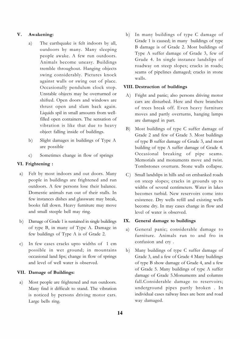
V. Awakening:
a) The earthquake is felt indoors by all,outdoors by many. Many sleepingpeople awake. A few run outdoors.Animals become uneasy. Buildingstremble throughout. Hanging objectsswing considerably. Pictures knockagainst walls or swing out of place.Occasionally pendulum clock stop.Unstable objects may be overturned orshifted. Open doors and windows arethrust open and slam back again.Liquids spil in small amounts from well-filled open containers. The sensation ofvibration is like that due to heavyobject falling inside of buildings.
b) Slight damages in buildings of Type Aare possible
c) Sometimes change in flow of springs
VI. Frightening :
a) Felt by most indoors and out doors. Manypeople in buildings are frightened and runoutdoors. A few persons lose their balance.Domestic animals run out of their stalls. Infew instances dishes and glassware may break,books fall down. Heavy furniture may moveand small steeple bell may ring.
b) Damage of Grade 1 is sustained in single buildingsof type B, in many of Type A. Damage infew buildings of Type A is of Grade 2.
c) In few cases cracks upto widths of 1 cmpossible in wet ground; in mountainsoccasional land lips; change in flow of springsand level of well water is observed.
VII. Damage of Buildings:
a) Most people are frightened and run outdoors.Many find it difficult to stand. The vibrationis noticed by persons driving motor cars.Large bells ring.
b) In many buildings of type C damage ofGrade 1 is caused; in many buildings of typeB damage is of Grade 2. Most buildings ofType A suffer damage of Grade 3, few ofGrade 4. In single instance landslips ofroadway on steep slopes; cracks in roads;seams of pipelines damaged; cracks in stonewalls.
VIII. Destruction of buildings
A) Fright and panic; also persons driving motorcars are disturbed. Here and there branchesof trees break off. Even heavy furnituremoves and partly overturns, hanging lampsare damaged in part.
B) Most buildings of type C suffer damage ofGrade 2 and few of Grade 3. Most buildingsof type B suffer damage of Grade 3, and mostbuilding of type A suffer damage of Grade 4.Occasional breaking of pipe seams.Memorials and monuments move and twist.Tombstones overturn. Stone walls collapse.
C ) Small landslips in hills and on embanked roadson steep slopes; cracks in grounds up towidths of several centimeters. Water in lakesbecomes turbid. New reservoirs come intoexistence. Dry wells refill and existing wellsbecome dry. In may cases change in flow andlevel of water is observed.
IX. General damage to buildings
a) General panic; considerable damage tofurniture. Animals run to and fro inconfusion and cry .
b) Many buildings of type C suffer damage ofGrade 3, and a few of Grade 4 Many buildingsof type B show damage of Grade 4, and a fewof Grade 5. Many buildings of type A sufferdamage of Grade 5.Monuments and columnsfall.Considerable damage to reservoirs;underground pipes partly broken . Inindividual cases railway lines are bent and roadway damaged.

15
c) On flat land overflow of water, sand and mudis often observed. Ground cracks to widthsof upto 10cm, on slopes and river banks morethan 10cm; furthermore a large number ofslight cracks in ground; falls of rock, manylandsides and earth flows; Large waves inwater. Dry wells renew their flow and existingwells dry up.
X. General destruction of buildings
a) Many buildings of Type C sufferdamage of Grade 4, and a few of Grade 5.Many buildings of type B show damage ofGrade 5; most of type A have destruction ofGrade 5; critical damage to dams and dykesand sever damage to bridges. Railway linesare bent slightly. Underground pipes arebroken or bent. Road paving and asphaltshow waves.
b) In ground, cracks up to widths of severalcentimeters, sometimes upto 1 metre. Parallelto water courses occur broad fissures. Looseground slides from steep slopes. From riverbanks and steep coasts, considerablelandslides are possible. In coastal areas,displacement of sand and mud; change ofwater level in wells; water from canals, lakes,rivers, etc, thrown on land. New lakes occur.
XI. Destruction
a) Severe damage even to well built buildings,bridges, water dams and railway lines;highways become useless; underground pipesdestroyed.
b) Ground considerably distorted by broadcracks and fissures, as well as by movementin horizontal and vertical directions;numerous landslips and falls of rock. Theintensity of the earthquake requires to beinvestigated specially.
XII. Landscape changes
a) Practically all structures above and belowground are greatly damaged or destroyed.
b) The surface of the ground is radically changed.Considerable ground cracks with extensivevertical and horizontal movements areobserved. Falls of rock and slumping of riverbanks over wide areas, lakes are dammed;waterfalls appear and rivers are deflected. Theintensity of the earthquake requires to beinvestigated specially.
ZONING IN TERMS OF DAMAGE OFMANMADE STRUCTURES
Four zones have been identified based on damagerisk. These are:
Zone II: Low damage risk with MSK intensityVI or less
Zone III: Moderate damage risk with MSKintensity VII.
Zone IV: High damage risk with MSK intensityVIII.
Zone V: Very high damage risk with MSKintensity IX and above.
REFERENCE :
1. Vulnerability Atlas of India, Published byBuilding Materials and TechnologyPromotion Council of Govt. of India(BMPTC) (1997).
2. Geological Society of India (1994): Laturearthquake: Published by Geological Societyof India, Bangalore.
3. Geological Society of India (1995): UttarKashi earthquake: Published by GeologicalSociety of India, Bangalore.
4. Geological Society of India (2003):Earthquake studies in Peninsular India since1993: Published by Geological Society ofIndia, Bangalore.

16
Disclaimer :The views expressed by the writers do not necessarily reflect the views of either
Centre for Environmental Studies or The Editor.
This newsletter is also available in electronicform at our website:
www.orienvis.nic.in and www.cesorissa.org
For Subscription & Query; Please Contact to :
Centre for Environmental Studies,Forest & Environment Department, Government of OrissaN-1/247, IRC Village, Nayapalli, Bhubaneswar-751015Tel. No.- 0674 - 2551853; Fax- 0674 - 2553182e-mail: [email protected] & [email protected] - www.orienvis.nic.in & www.cesorissa.org
Acknowledgement:We extend our thanks to Prof. (Dr.) N.K. Mahalik, Retd. Professor & Head, Geology Dept.,
Utkal University (e-mail: [email protected]) in preparation of this issue.
Hon’ble Chief Minister, Orissa; Shri Naveen Patnaik observing an eco-exhibition & releasing ENVIS Website
If undelivered please return to :ENVIS CentreCentre for Environmental StudiesForest & Environment DepartmentGovernment of OrissaPlot No. - N-1/247, IRC Village,Bhubaneswar-751015, Orissa
To,
BOOK POST
ENVIS EDITORIAL TEAM
Shri Bhagirathi Behera, IFS, DirectorPravat Mohan Dash, Programme OfficerPrashanta Ku. Nayak, Programmer