east 11th and 12th street development strategy
TRANSCRIPT

Draft Technical Report
East 11th and 12th Street Development Strategy Prepared for: City of Austin Prepared by: Economic & Planning Systems, Inc. McCann Adams Studio Urban Design Group Adisa Communications January 9, 2012 EPS #20128

Table of Contents
1. INTRODUCTION AND SUMMARY.................................................................................. 1
Background..............................................................................................................1
Summary of Findings and Recommendations................................................................4
2. REGULATORY ISSUES AND STRATEGIES ...................................................................... 10
3. INFRASTRUCTURE ISSUES AND STRATEGIES ................................................................. 14
4. BUSINESS ISSUES AND STRATEGIES ......................................................................... 20
5. HOUSING ISSUES AND STRATEGIES .......................................................................... 25
6. DISPOSITION ISSUES AND STRATEGIES...................................................................... 30
7. EAST 12TH STREET AND CHICON .............................................................................. 37
APPENDICES
Appendix A: East 11th and 12th Street Development Constraint Analysis
Appendix B: East 11th and 12th Street Redevelopment Infrastructure Report

List of Figures
Figure 1 Map of the Study Area. ......................................................................................2
Figure 2 Vacant Public Parcels .........................................................................................7
Figure 3 Vacant and Underutilized Parcels....................................................................... 15
Figure 4 Block 6: Curve to Waller Street......................................................................... 33
Figure 5 Block 7: Waller to Navasota.............................................................................. 34
Figure 6 Potential Development – E. 12th & Chicon.......................................................... 38

Economic & Planning Systems, Inc. 1 P:\21000s\21028Austin11th12th\EPS Materials\21028rpt_010912.doc
1. INTRODUCTION AND SUMMARY
Backg round
The Central East Austin area has undergone significant change in recent years, but has also not yet fulfilled its potential as a mixed-use urban community. In particular, the areas immediately flanking East 11th and 12th Streets (see Study Area map on Figure 1) have been envisioned as opportunities for significant revitalization. The community, private developers, non-profit organizations, and the City of Austin have initiated a variety of efforts to improve the Study Area, including the following examples (see the four pictures on the following page):
Creation of various plans and regulations including the Central East Austin Master Plan, the Urban Renewal Plan (URP), and separate Neighborhood Conservation Combining Districts (NCCDs) for East 11th and East 12th Streets.
Development of the Street-Jones and Snell Buildings (office with ground floor retail), the East Village Lofts (mixed-use with condominiums above retail), and the Robertson Hill apartment complex.
Funding and project management of the Dedrick-Hamilton House and African-American Cultural and Heritage Facility.
Funding and completion of the historic rehabilitation of the Connelly-Yerwood House located on East 12th Street.
Funding several façade improvement projects at the corner of East 12th Street and Chicon Street.
Improvements to infrastructure and streetscape on East 11th Street, and construction of community parking lots on both East 11th and East 12th Street.
Despite these steps forward, the community recognizes that the East 11th and 12th Street corridors remain underutilized, with numerous vacant parcels, underperforming businesses, and other indicators of unfulfilled potential in an area that sits immediately east of Downtown Austin and the State of Texas’ capitol complex, and just south of the rapidly redeveloping former Mueller Airport. The City of Austin’s Department of Neighborhood Housing and Community Development has retained a team of consultants to define a Development Strategy for the Study Area. The consulting team is led by Economic & Planning Systems (EPS) and also includes McCann Adams Studio (urban design and planning), Urban Design Group (civil engineering), and Adisa Communications (public relations). The EPS Team has sought to identify key initiatives that can catalyze development in the corridors.

East Village Lofts
East 12th Street and Chicon Street Façade Improvements
East 11th Street Infrastructure and Streetscape Improvements
Connelly-Yerwood House Historic Rehabilitation
2

00 4002 0Feet
DRAFT
AERIAL AND PROJECT BOUNDARIES
East 11th and 12th Street Redevelopment StrategyPrepared by McCann Adams Studio
AUGUST 25, 2011
CMTA
MET
RORA
IL
ROSEWOOD AVE.
E. 11TH ST.
E. 12TH ST.
E. 13TH ST.
COTTON ST.
HACKBERRY ST.
INTE
RSTA
TE H
IGH
WAY
35
CATALPA ST.
OLIVE ST.
JUNIPER ST.
NAVA
SOTA
ST.
SAN
BERNA
RD ST.
AN
GELIN
A ST.
COM
AL ST.
PENNSYLVANIA AVE.
NEW YORK AVE.
LOTTPARK
SWEDEHILL W
ALLER ST.
OLA
ND
ER ST.
ROSEWOODPARK
BOGGYCREEKPARK
WA
LLER
ST.
CURV
E ST
.
BRA
NCH
ST.
SAN
MA
RCO
S ST
.
WA
LLER
ST.
LYD
IA S
T.
NAV
ASO
TA S
T.
AN
GELIN
A ST.
CON
CHO
ST.
LEON
A ST.
SALIN
A ST.
CHICO
N ST.
POQ
UITO
ST.
SAN
BERNA
RD ST.
NAVA
SOTA
ST.
E. 10TH ST.
OAKWOODCEMETERY
STATECEMETERYOF TEXAS
KEALINGPARK
CARVER MUSEUM
& CULTURAL CENTER
LIBRARY
BLACKSHEARELEMENTARY
SCHOOL
KEALINGMIDDLESCHOOL
BRACKENRIDGEHOSPITAL
BOB HARRISON
Figure 1 3

East 11th and 12th Street Development Strategy Draft—Technical Report 1/9/12
Economic & Planning Systems, Inc. 4 P:\21000s\21028Austin11th12th\EPS Materials\21028rpt_010912.doc
The Development Strategy builds on redevelopment and revitalization efforts by describing a coherent strategy, which the EPS Team believes represents positive direction for near-term initiatives that can advance development within the Study Area, and generate stronger interest by the private development industry in fulfilling the community’s goals.
In the few months since September 2011, the EPS Team has visited with numerous community stakeholders (property owners, business owners, private and non-profit developers, neighborhood organizations, etc.) and conducted site surveys, market analysis, and an assessment of infrastructure conditions to identify key issues and opportunities for future development. Importantly, this Development Strategy is not intended to alter the community’s vision for these corridors, as represented in the various planning documents of recent years, but rather to advance that vision by identifying pathways to its successful implementation.
Summa ry o f F ind ings and Recommenda t ions
The EPS Team recognizes the potential of the Study Area to enhance livability in East Austin generally, and to participate more fully in the economic vitality of the City and region. We believe the vision for the community – a mixed-use environment of moderate scale that offers community services and employment opportunities and respects the adjacent residential neighborhoods, as reflected in the various planning documents and regulations – represents an appropriate and achievable future for the Study Area. As such, no major overhaul to the vision is recommended. However, numerous steps can be taken that can help realize that positive vision. The EPS Team recommends the following efforts be undertaken to facilitate desired revitalization of the East 11th and 12th Street Study Area:
1. Clarify the development regulations and process by reconciling the NCCDs and Urban Renewal Plan. The NCCDs are the controlling zoning regulation for the Study Area. However, the NCCDs indicate that developments must conform with the “Project Controls” for various parcels as outlined in the Urban Renewal Plan (URP), which was originally adopted in 1999 and has been modified five times thus far. On parcels where the URP still has these Project Controls (many have been eliminated over the years), proposals that do not strictly conform to the parcel-specific descriptions of uses, amounts of development, etc., can trigger the need for multi-level project approvals even if those projects otherwise conform to the NCCD entitlements. The community should re-confirm the importance of the remaining specific Project Controls, or else modify them in favor of more flexible requirements as already have been enacted on many development sites in the Study Area. If such flexibility were created for those parcels, NCCD-conforming projects could be processed administratively, rather than requiring lengthy, costly, and uncertain review by the Urban Renewal Board, the Planning Commission, and the City Council. In addition, the URP should be updated as a single consolidated document; presently, it is available as the original document plus five amendments, making it very difficult to navigate.
2. Establish $10 million in public funding to underground utilities, improve streetscape, and subsidize wastewater infrastructure upgrades on East 12th Street. In recent years, the City has upgraded infrastructure capacity and placed utilities underground in certain locations on 11th Street, and also on East 7th Street. The removal of many poles and wires and improvement of the un-landscaped, utilitarian streetscape on East 12th Street would signal the City’s support of the area, and improve its “look and feel” to

East 11th and 12th Street Development Strategy Draft—Technical Report 1/9/12
Economic & Planning Systems, Inc. 5 P:\21000s\21028Austin11th12th\EPS Materials\21028rpt_010912.doc
attract new businesses and other development and community activity. The EPS Team has estimated that these streetscape and undergrounding projects would have a combined cost of roughly $9 million. In addition, wastewater infrastructure in certain areas of East 12th Street may need replacement and upgrades to accommodate future development. The EPS Team has estimated that these wastewater improvements would cost roughly $1 million. This $10 million total funding also will help to improve the feasibility of new development and attract private investment by removing significant costs from projects’ financing needs.
3. Dedicate resources to attract a grocery store to anchor the area’s businesses. The Study Area has no grocery store, is described as a “food desert,” and most community members indicate they travel well outside the neighborhood to get their groceries. In addition to serving the community, a grocery store could anchor more extensive community retail and services. As the area’s population has grown and increased in income levels, and as the residential and employee population of Downtown Austin continues to grow, a mid-sized grocery store should be increasingly feasible in the Study Area. Staff resources should be devoted to pursuing such a tenant – potentially incorporated into a mixed-use development that takes advantage of the NCCD’s higher-density allowances – and financial incentives such as New Markets Tax Credits should be explored as necessary.
4. Encourage the inclusion of locally owned businesses and “below market rate” commercial space in new development. Most of the businesses in the Study Area are small and locally owned, and may be susceptible to displacement as new development occurs, particularly if they are renting rather than owning their space. Through the development solicitation process, all mixed-use or commercial projects on publicly-controlled sites should be strongly encouraged to provide at least 50 percent of commercial space for locally-owned businesses, and may be granted further preference if they also include some commercial space at lease rates below market-rates.
5. Encourage mixed-income housing development, plus new housing for families and seniors. Market analysis indicates that the area has a comparatively high concentration of subsidized housing, relative to the rest of the City, but that seniors and modest-income families have been moving out of the neighborhood, in part due to rising housing costs or taxes. New development should be encouraged to provide some units large enough for families, including a goal that 10 percent of new units on currently public land should have three or more bedrooms. Also, the City may wish to support senior housing development on one of the publicly-controlled sites, or may offer incentives to achieve such a development on a privately held site such as the block between 11th and 12th Street just east of IH 35 or at 12th and Chicon. Other projects that include housing on publicly-controlled sites should be encouraged to provide 10 percent of units affordable at up to 60 percent of Median Family Income (if rentals), but otherwise focus on market-rate and/or ownership housing. Achievement of these strategies would increase the supply of market-rate housing in the community and dilute the current concentration of “affordable” rental units, but also address some continuing needs for impacted market segments.
6. Enhance public parking on East 11th and 12th Street to support local businesses and reduce costs for new private development. For any development that occurs on publicly owned parcels on both East 11th and 12th Streets, proposing developers should be encouraged through the selection process to provide surplus “community parking” spaces

East 11th and 12th Street Development Strategy Draft—Technical Report 1/9/12
Economic & Planning Systems, Inc. 6 P:\21000s\21028Austin11th12th\EPS Materials\21028rpt_010912.doc
that can serve the greater area. Many of the developable sites on East 12th Street are constrained by size, and may have difficulty achieving the higher density, higher value uses enabled by current regulations if they must provide even the minimum code-required parking on-site. Moreover, the bike lanes both east- and west-bound on East 12th Street have reduced the supply of on-street parking by about half. A new public parking lot on Tract 13 between Waller and Navasota could provide roughly 20 spaces, and reduce the need for costly and space-intensive on-site parking on nearby sites. Also, “duck-in” parking should be encouraged along the south side of East 12th Street and the north-south streets approaching East 12th Street, to provide a less costly alternative to structured parking. Finally, the existing community parking lots on both East 11th and 12th Streets should be maintained until and unless other future projects on public or private land can provide similar public parking capacity.
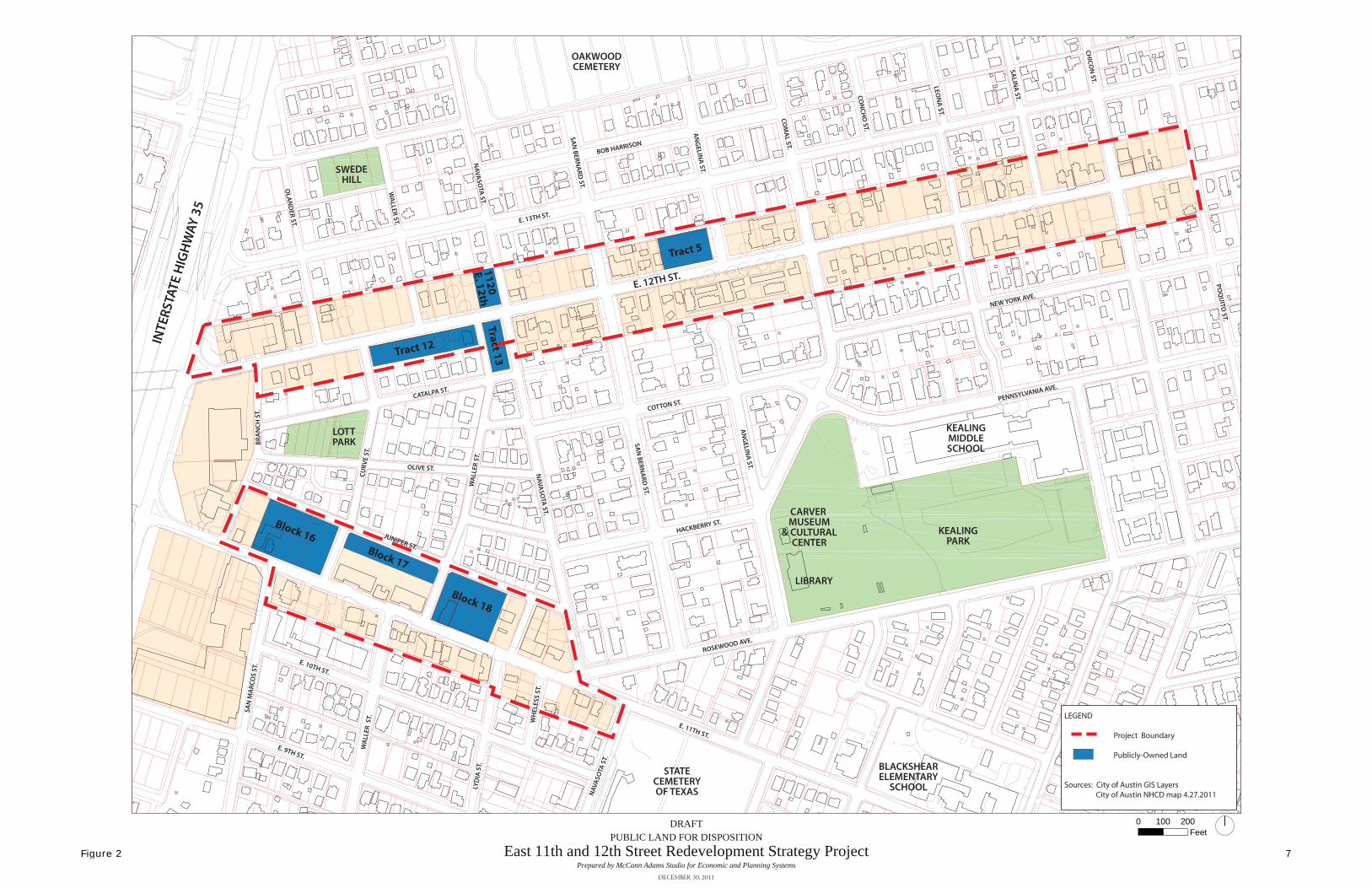
7. Offer other publicly-held land for development as soon as possible. The City of Austin or other quasi-public entities control several parcels in different locations throughout the Study Area (see Figure 2). Some of this land has been in public control for over a decade, and has been cleared of previous “slum and blight” conditions but not yet developed. Some of these sites were acquired or improved using Federal funding, and are subject to requirements regarding development for specific purposes or repayment of those funds. Infill development on these sites will enhance the physical environment, add services desired by the community and/or create additional support for existing businesses – all signaling to the development industry that the Study Area is receiving attention from the City. Requests for Proposals (RFPs) should be prepared and distributed for several sites, with minimum standards and desirable “value-added” elements specified. Specific recommendations for various sites include the following:
a. Block 16 – An RFP was issued for this URA-controlled block in 2008, but received little developer interest, primarily because the real estate market and financing industry were in turmoil at that time. Most of the requirements of the RFP were reasonable – seeking mixed-use development and requiring modest affordable housing goals (if building rental housing), green building standards, etc. – and need not be substantially altered in a re-issued RFP. In an updated RFP, synergies with the adjacent African American Cultural and Heritage Facility should be strongly encouraged, as should the inclusion of space for local businesses. To the extent allowed by law, it would be helpful to provide some flexibility in the financing of the land acquisition, including potential for ground leasing, modestly deferred payments, etc., that may help to enhance opportunities for desirable community benefits.
b. Block 17 – This land, sitting immediately north of the Street-Jones and Snell Buildings and facing Juniper Street, is planned to be developed for townhomes or live/work lofts. The City should expedite development of this land, either through direct construction carried out by the Austin Housing Finance Corporation or near-term transfer of the property to a motivated developer.
ROSEWOOD AVE.
E. 11TH ST.
E. 12TH ST.
E. 13TH ST.
COTTON ST.
HACKBERRY ST.
INTE
RSTA
TE H
IGH
WAY
35
CATALPA ST.
OLIVE ST.
JUNIPER ST.
NAVA
SOTA
ST.
SAN
BERNA
RD ST.
AN
GELIN
A ST.
COM
AL ST.
PENNSYLVANIA AVE.
NEW YORK AVE.
LOTTPARK
SWEDEHILL
WA
LLER ST.
OLA
ND
ER ST.
WA
LLER
ST.
CURV
E ST
.
BRA
NCH
ST.
SAN
MA
RCO
S ST
.
WA
LLER
ST.
LYD
IA S
T.
NAV
ASO
TA S
T.
AN
GELIN
A ST.
CON
CHO
ST.
LEON
A ST.
SALIN
A ST.
CHICO
N ST.
POQ
UITO
ST.
SAN
BERNA
RD ST.
NAVA
SOTA
ST.
E. 10TH ST.
OAKWOODCEMETERY
STATECEMETERYOF TEXAS
KEALINGPARK
CARVER MUSEUM
& CULTURALCENTER
LIBRARY
BLACKSHEARELEMENTARY
SCHOOL
KEALINGMIDDLESCHOOL
BOB HARRISON
ST.
E. 9TH ST.
WH
ELES
S ST
.
Block 17
Block 16
Block 18
Tract 12
Tract 131120 E. 12th
Tract 5
00 2001 0Feet
DRAFTPUBLIC LAND FOR DISPOSITION
East 11th and 12th Street Redevelopment Strategy ProjectPrepared by McCann Adams Studio for Economic and Planning Systems
DECEMBER 30, 2011
LEGEND
Project Boundary
Publicly-Owned Land
Sources: City of Austin GIS Layers City of Austin NHCD map 4.27.2011
Figure 2 7

East 11th and 12th Street Development Strategy Draft—Technical Report 1/9/12
Economic & Planning Systems, Inc. 8 P:\21000s\21028Austin11th12th\EPS Materials\21028rpt_010912.doc
c. Block 18 – This URA land just east of the Snell Building on East 11th Street is home to the Victory Grill and East Room. The community should consider modifying the Urban Renewal Plan to provide site plan flexibility similar to that already provided for Block 16, or confirm that the specific Project Controls for Block 18 should be maintained. Following that discussion, an RFP should be issued. Developers should be encouraged to propose various ways to support the historic properties and the African American Cultural Heritage District on this block, in addition to the provision of community parking and space for local businesses.
d. Tract 12 – This City owned land on East 12th Street has already been planned and platted for single-family attached housing (e.g., townhomes). To contribute more substantially to the commercial activity on East 12th Street, the community should consider modification of the URP to allow uses such as live/work units offering ground floor commercial space within side-by-side townhomes. The land should be sold as quickly as possible to a motivated developer.
e. Tract 13 – This City owned land is more problematic to develop for housing than most sites, because it is oriented north-south and has limited width between Curve and Waller Street. The community should consider modifying the URP to encourage retail development on the East 12th Street frontage, plus community parking spaces. If such modification is approved, the City can issue an RFP for this site that allows for ground leasing, and seek to dedicate the revenues achievable through the leasing opportunity to the modest improvement of the site for community parking and potentially open space. If consensus cannot be reached to modify the URP for such use, the land should be sold as quickly as possible to a motivated developer.
f. 1120 East 12th Street – This small site should be sold to the highest bidder as quickly as possible, as it offers little opportunity for desired development as a stand-alone site.
g. Tract 5 – This URA site on the north side of East 12th Street between San Bernard and Angelina, is designated in the URP for mixed-use and/or commercial development. The 0.6-acre site may also be large enough to accommodate senior housing as part of a mixed-use project, and could also be a potential site for a neighborhood grocery. The resolution of desirable uses for this site may require some community discussion, so the issuance of an RFP may be delayed beyond the next year or two.
h. Community Parking – The existing community parking lots on East 11th and East 12th Street should only be considered for more intensive development if and when adequate replacement spaces can be provided elsewhere in their vicinity.
8. The City must continue law enforcement efforts around East 12th Street and Chicon, and should also seek to support development and businesses in the area. The Austin Police Department has conducted numerous efforts to improve security and law enforcement in this area, including closure of problem houses, enforcement of trespassing/loitering prohibitions, community clean-ups, etc. These efforts should continue, as should the community discussion regarding the merits of security cameras. The City does not own any properties near this intersection, but can provide technical assistance and financial incentives to support new development and existing businesses. The infrastructure funding recommended above may be particularly beneficial for this area, which is a minor commercial

East 11th and 12th Street Development Strategy Draft—Technical Report 1/9/12
Economic & Planning Systems, Inc. 9 P:\21000s\21028Austin11th12th\EPS Materials\21028rpt_010912.doc
node that can be significantly enhanced through streetscape and utility undergrounding, and has the most pressing need for wastewater improvements to expand capacity for envisioned development.
9. Numerous City departments must coordinate their efforts to implement desired improvements in the Study Area. NHCD and the Urban Renewal Board can initiate certain actions, including preparation of submissions for infrastructure funding, discussions of modifications to existing development regulations, and disposition or development of public land. Other City departments should also be engaged as a Technical Advisory Group to prioritize and implement desired strategic actions. Examples of such departments and their potential roles include, without limitation, the following:
Law and Planning & Development Review – minor modifications and more user-friendly organization to development regulations
Public Works, Austin Energy, Watershed Protection, and Austin Water Utility – prioritization, design and construction of infrastructure upgrades
Economic Growth and Redevelopment Services, Real Estate, and Contract and Land Management – solicitation and selection of development proposals, disposition of land prioritization of funds needed for future bond program(s)
Austin Police Department – continued law enforcement and community engagement
The EPS Team believes that implementation of the strategies and actions summarized above, and discussed in greater detail on subsequent pages, will make major and positive differences in the East 11th and 12th Street Study Area. The combination of physical improvements, regulatory clarifications, market and business enhancement, and organizational energy will signal the City’s renewed commitment to the area. Private investment will be attracted, while the community’s longstanding vision and goals will be respected. And the Study Area will more fully capitalize on its great potential as a vibrant urban neighborhood in Austin.

Economic & Planning Systems, Inc. 10 P:\21000s\21028Austin11th12th\EPS Materials\21028rpt_010912.doc
2. REGULATORY ISSUES AND STRATEGIES
The Study Area is subject to multiple planning documents and development regulations, each of which has been crafted through extensive public input over several decades. The EPS Team believes that these various documents and regulations are generally consistent with one another and with the community’s preferred vision for future development. We further conclude that the regulations generally promote financially feasible development in the Study Area, rather than detract from the feasibility of such development. However, we have identified a few areas where the regulations may be clarified and/or modestly amended to further enhance the viability of development in the Study Area without compromising the integrity of the community’s vision.
Issue R-1: The various planning documents have minor but important inconsistencies.
The NCCDs for East 11th Street and East 12th Street provide the zoning regulations for future development in each area. The NCCDs generally promote the same character of development as is envisioned in the Urban Renewal Plan and the Central East Austin Master Plan – mixed-use development featuring both commercial space and housing, with an emphasis on dining and entertainment on East 11th Street and an emphasis on housing and community serving uses on East 12th Street. However, in some specific instances, the NCCDs and the URP are inconsistent, and this creates confusion for landowners, developers, and City development staff as well as creating procedural hurdles to gain approval for a project that may conform to one regulatory document but not the other. Adding to this confusion and difficulty, the URP has been modified a total of five times to date, but the modifications are found in separate documents rather than in a single updated URP.
Strategy R-1a: Consider eliminating the most prescriptive “Project Controls” from the URP and any zoning regulations in the NCCD that are more prescriptive than the URP.
The development process could be simplified and more private investment attracted to the Study Area if landowners and developers are given more flexibility to design projects consistent with the general vision for the Study Area, rather than having highly specific use and design requirements. For example, the URP “Project Controls” for Block 18 (URP “Project 11-5”) on East 11th Street still indicate that the bulk of new development on the site should be commercial space, that only 10-15 townhomes can be constructed (no other housing is allowed), and that 135-150 Community Parking Spaces must be provided (as shown under Modification #1 from 2001), though under Modification #5 (2008) “Community Parking Spaces” are now defined as those “in excess of the normal requirement which is made available to other business uses within the URP as remote parking.” A strict interpretation of the various modifications may now suggest that Block 18 must provide adequate parking for its own uses, plus another 135-150 spaces for off-site beneficiaries. A mixed-use project providing multifamily housing rather than office space above ground floor retail may have a similar physical presence on Block 18 but be more feasible, and may be able to provide more community parking or other benefits due to both financial and physical considerations. Removing the highly prescriptive Project Controls for this site may allow developers to be more creative regarding their uses, designs, and amenities, and may result in a superior project for the community.

East 11th and 12th Street Development Strategy Draft—Technical Report 1/9/12
Economic & Planning Systems, Inc. 11 P:\21000s\21028Austin11th12th\EPS Materials\21028rpt_010912.doc
Moreover, there is occasional inconsistency within and among the various documents. One example of a disconnect: URP Modification #3 (2005) states that Project 11-9 has “Permitted Use” that includes “office or residential over retail,” but goes on the prescribe 6,000 to 10,000 square feet of office space and zero residential units. This type of inconsistency is less of an issue on East 12th Street, for which URP Modification #3 has eliminated most of the prescriptive Project Controls in favor of more flexibility. Even there, however, there are examples of potential over-prescription in the URP; “Project 12-3” (including publicly owned Tracts 12 and 13) is indicated to have a “Permitted Use” that includes mixed-use, townhomes, single-family residential, and community parking on various specific subareas, despite the fact that the NCCD zoning allows mixed-use development on all of those same parcels. On the other hand, the East 11th Street NCCD limits multifamily residential densities to 18-27 units per acre in Subdistrict 1 and prohibits any “street-level” townhomes or condominiums, while the URP now makes no such limitations.
In each instance where there is a highly prescriptive regulation or inconsistencies between documents (URP vs. NCCD), the EPS Team recommends that less prescriptive regulations be considered for adoption for both documents. The community must be engaged in this process, to respect the considerable time spent formulating the past and current regulations and also to ensure that any revisions maintain the general vision if not the specific requirements in the current documents. These discussions can be initiated by the Urban Renewal Board and any subsequent modifications can be implemented with the assistance of the Law and Planning and Development Review departments.
Strategy R-1b: Consider amending the URP and NCCDs in ways that can enhance the feasibility of development without compromising the general vision for the Study Area or protections for the surrounding neighborhoods.
In Appendix A to this report, an analysis by McCann Adams Studio provides a synopsis of the various regulatory documents affecting the Study Area, as well as various suggestions for minor improvements to those documents that can enhance the feasibility and/or positive impacts of development. Examples include, without limitation, potential changes to floor-area-ratios for smaller lots, setback requirements, re-classification of certain permitted or conditional uses, etc. As these are numerous but highly specific, we refer the reader to that Appendix for these detailed suggestions. Please note that the “recommendations” provided in Appendix A should be regarded as suggestions for consideration and discussion by the community, and are not necessarily critical components of this Development Strategy unless they are specifically reflected within the primary body of this document.
Strategy R-1c: Update the development regulatory documents to reflect all modifications approved to date.
During this study, the EPS Team found it challenging to identify the most up-to-date regulations for various sites; the small, local landowners and developers expected to be the driving force for change in the Study Area are likely to have similar difficulty navigating these documents. Rather than having a URP plus five modification documents to review, having a single document to refer to will make this interpretation of the URP much more clear for all participants. Alternatively, it may be easier or clearer to amend the NCCDs. The City’s Legal and Planning & Development Review departments should be consulted regarding the preferred process for updating the information.

East 11th and 12th Street Development Strategy Draft—Technical Report 1/9/12
Economic & Planning Systems, Inc. 12 P:\21000s\21028Austin11th12th\EPS Materials\21028rpt_010912.doc
Issue R-2: Commercial Design Standards (Land Development Code: Subchapter E) promote attractive but costly streetscape improvements along Study Area streets.
Subchapter E (“Design Standards and Mixed Use”) (2006; revised 2008) was adopted as part of the City’s Land Development design standards and applies City-wide to most commercial projects. This Subchapter presents a series of development standards meant to improve the urban design quality and pedestrian accessibility of commercial and mixed-use development along public streets, as well as along internal drives of larger sites. The design standards are applied per roadway type along which the proposed development is located. The City is currently considering many revisions to Subchapter E that should address various unintended consequences of the ordinance.
As presently interpreted, properties in the Study Area are subject to these standards, with East 11th and 12th Streets being considered “Urban Roadways,” as are all of the intersecting north-south streets in the Study Area. In general, commercial development along these frontages would be required to provide a 12-foot wide streetscape, including a seven-foot wide landscape zone and a five-foot sidewalk or “through” zone. These standards, while promoting an attractive streetscape and environment, may be difficult for some projects in the East 11th and 12th Street Study Area to achieve at a reasonable cost. Lots are relatively shallow in many areas, and along much of 12th Street, the recently installed bike lanes have required the removal of on-street, parallel parking. Requiring properties to provide significant area and expense for sidewalks and streetscaping reduces the developable land area and adds costs, both of which affect the feasibility of development project.
Strategy R-2: Exempt the Study Area from the specific provisions of Subchapter E, and establish new standards within the NCCDs that regulate streetscape requirements in a more context-sensitive manner.
Subchapter E provides appropriate goals for commercial streets in general, but does not necessarily reflect the unique conditions within the Study Area, including parcel dimensions, parking concerns, the presence of major electrical and telecommunication lines, etc. Within this context, certain provisions may be found to be inappropriate or present hardships for the redevelopment of East 11th and 12th Streets. The EPS Team recommends that a Study Area-specific streetscape design be prepared that balances the Subchapter E goals and specifications with the conditions of Study Area parcels (e.g., Is important development opportunity lost due to streetscape requirements, particularly in combination with potential parking approaches? Do topographic and/or utility issues present unique challenges to achieving the standards?). The resulting streetscape design standards may be added to the NCCDs for the Study Area (or included as amendments as necessary where streetscape is already addressed as in the East 11th Street NCCD), which would in effect “trump” Subchapter E because in case of conflict, NCCDs supersede the regulations of Subchapter E. The streetscape design study would then become the basis for improvements using funding sources as suggested in the “Infrastructure Issues and Strategies” section of this document.

East 11th and 12th Street Development Strategy Draft—Technical Report 1/9/12
Economic & Planning Systems, Inc. 13 P:\21000s\21028Austin11th12th\EPS Materials\21028rpt_010912.doc
Issue R-3: On-street parking opportunities are limited due to roadway right-of-way sizes, curb cuts, and recently installed bike lanes.
The City Council-adopted Bicycle Plan (2009) called for dedicated, striped bike lanes on both East 11th and 12th streets, which have recently been implemented on both streets. On East 12th Street, on-street parallel parking is now allowed only along the north side of the street, but narrow right-of-way, curb cuts, intersections, etc. result in limited on-street parking even on that one side of the street. It is desirable to increase the amount of public parking spaces on and near East 12th Street, so that this corridor can better support mixed-use commercial uses and small businesses. Ensuring easy, on-street parking in the 12th Street corridor will be essential to the success of this corridor for two reasons: it will allow business owners the ability to avail themselves of this parking, in lieu of constructing it on site, therefore making these projects more affordable; and it will provide the kind of easy-access parking that make businesses more accessible and desirable. The north-south streets crossing East 12th Street offer an opportunity to increase on-street parking that could be located in the first half or whole block north and south of the corridor.
Strategy R-3: Amend the NCCDs as necessary to promote additional on-street parking.
The East 11th Street NCCD specifically recommends that on-street parking on East 11th Street and Rosewood be phased out as new developments and associated parking become available. This goal places a burden on new projects to provide more costly on-site and/or structured parking, rather than using the comparatively less costly on-street parking. Both NCCDs should allow for on-street, angle-in or parallel parking to be developed as of right along the north-south streets, and for duck-in parallel parking to be developed along the south edge of East 12th Street, immediately outside or to the south of the eastbound bike lane. In addition, allow this and any other existing or newly created on-street parking to count toward the parking requirements for the fronting uses/properties. Finally, where practicable, curb cuts should be limited to maximize the space for on-street parking.

Economic & Planning Systems, Inc. 14 P:\21000s\21028Austin11th12th\EPS Materials\21028rpt_010912.doc
3. INFRASTRUCTURE ISSUES AND STRATEGIES
During the stakeholder interviews and public meetings held for the Development Strategy, numerous individuals expressed concern about the adequacy of infrastructure in the Study Area, particularly along East 12th Street. Infrastructure along East 11th Street has already been improved in recent years. Some stakeholders cited the perception of inadequate infrastructure capacity as a major deterrent to future development, believing that proposed projects would need to wait for and possibly fund upgrades to water, wastewater, drainage, and other systems in order for development to occur.
The EPS Team has conducted an assessment of the conditions and capacity of various infrastructure elements in the Study Area. Urban Design Group, the civil engineering firm on the EPS Team, reviewed system maps, met with various City and utility departments, and conducted on-site surveys of conditions for various infrastructure elements. The results of that analysis are provided as Appendix B to this document. Note that the EPS Team has tested the capacity of the existing systems to serve 680,000 square feet of new development on East 12th Street – sufficient for a total of roughly 350 housing units, 170,000 square feet of office space, and 170,000 square feet of ground floor retail in mixed-use building on roughly 13 acres of identified vacant and underutilized parcels (see Figure 3).1
In general, the streetscape and overhead utilities present significant opportunities for improvement, and upgrades to certain sections of the wastewater utilities would benefit development opportunities. Public investment in these improvements would not only visibly enhance the area but also reduce the cost burden on redevelopment projects, making them more feasible in the near term and spurring revitalization in the Study Area.
As noted in the City of Austin’s Capital Improvement Program “Needs Assessment Planning Questionnaire,” there are numerous considerations for any public funding of capital facilities. The improvements recommended below address several of these considerations, including:
the creation of a “compact and connected Austin” by facilitating more dense development and stronger pedestrian linkages in neighborhoods near Downtown;
1 While the ultimate NCCD zoning for the area allows up to 930,000 square feet of development on these sites, the EPS Team believes the 680,000 square foot figure represents a more likely buildout scenario, given that some existing buildings will stay in place, that protected trees and other physical constraints are present on some sites, and that maximizing density would require very expensive parking and other design solutions which are not likely to be pursued by all of the potential developers of the sites. For example, the “Terrazo on 12th” project already approved for 1000-1022 East 12th Street proposes to build a total of roughly 30,000 square feet of development, though the NCCD for the site would allow as much as 100,000 square feet. As such, the EPS Team believes our “buildout” scenario is reasonably aggressive as a metric for assessing the adequacy of infrastructure for future development.

24
12
3 4
5 6 7 8 9 10
11121314 15
16 17
1819
2021
22
23 2526 27 28293031
32 33 3435 36
3837
40 41424344
4546
47 48 4950 51 5253
55 56 57 5859
60 61 62 6364 65 66
6768 69 707172 73
74757677
787980
81
8283 84
858687 8889 90 91
929394
9596
9798
100101
102
104105106
107108
109110111
112
103
113114115
116117
118119 120121
122123
124
125126127
128129130131
132133134135
136137138
139140141 142
143
144145146 147
148149150151152
54
24
39
99
153
154 155156
157
LEGEND
Church
Significant Trees
Moon Towers (Historic Landmarks)
Historic Landmarks
Vacant Land/Structure
Ownerships per COA NHCD map 11.9.2010
ARA-Owned
Urban Renewal-Owned
City of Austin-Owned
AHFC-Owned
00 4002 0Feet
DRAFT
INVENTORY OF PROPERTIES AND BUSINESSES
East 11th and 12th Street Redevelopment StrategyPrepared by McCann Adams Studio
AUGUST 25, 2011
CMTA
MET
RORA
IL
ROSEWOOD AVE.
E. 11TH ST.
E. 12TH ST.
E. 13TH ST.
COTTON ST.
HACKBERRY ST.
INTE
RSTA
TE H
IGH
WAY
35
CATALPA ST.
OLIVE ST.
JUNIPER ST.
NAVA
SOTA
ST.
SAN
BERNA
RD ST.
AN
GELIN
A ST.
COM
AL ST.
PENNSYLVANIA AVE.
NEW YORK AVE.
LOTTPARK
SWEDEHILL W
ALLER ST.
OLA
ND
ER ST.
ROSEWOODPARK
BOGGYCREEKPARK
WA
LLER
ST.
CURV
E ST
.
BRA
NCH
ST.
SAN
MA
RCO
S ST
.
WA
LLER
ST.
LYD
IA S
T.
NAV
ASO
TA S
T.
AN
GELIN
A ST.
CON
CHO
ST.
LEON
A ST.
SALIN
A ST.
CHICO
N ST.
POQ
UITO
ST.
SAN
BERNA
RD ST.
NAVA
SOTA
ST.
E. 10TH ST.
OAKWOODCEMETERY
STATECEMETERYOF TEXAS
KEALINGPARK
CARVER MUSEUM
& CULTURAL CENTER
LIBRARY
BLACKSHEARELEMENTARY
SCHOOL
KEALINGMIDDLESCHOOL
BRACKENRIDGEHOSPITAL
BOB HARRISON
Figure 3 15

East 11th and 12th Street Development Strategy Draft—Technical Report 1/9/12
Economic & Planning Systems, Inc. 16 P:\21000s\21028Austin11th12th\EPS Materials\21028rpt_010912.doc
the potential to create “green infrastructure” through streetscape design;
the potential to grow and invest in Austin’s economy by facilitating new development in an underutilized commercial corridor;
investment in projects prioritized in an adopted “neighborhood plan” (the Central East Austin Master Plan from 1999);
“facilitat(e) private investments that will produce jobs … and/or grow local business”;
“provide infrastructure to a previously underserved geographic area or population, directly contributing to mixed-use development, and directly contributing to the preservation or vitality of cultural or historical assets, sense of place, or neighborhood character”; and would represent
“significant progress toward achieving departmental business goals or priorities” (NHCD’s implementation of the Commercial Revitalization program for East 11th and 12th Streets).
The EPS Team believes these recommended infrastructure improvements are highly critical to the Development Strategy, and should be given strong near-term consideration for public funding given how many stated community objectives can be advanced through their implementation.
Issue I-1: Infrastructure upgrades are costly, and materially affect the feasibility of new development.
Throughout the City, the typical approach for infrastructure upgrades involves a review of the adequacy of infrastructure as projects are proposed, and the formation of agreements to extend services in locations where inadequacy is observed. The means of payment for these service extensions can vary from one system to another. For example, Austin Energy typically funds the extension or upgrade of electrical utilities as a capital cost, as their mandate is to provide adequate service and they are funded through user fees. By contrast, Austin Water Utility typically requires developers to fund water and wastewater system upgrades required to serve new projects, though the Water Utility may participate in the cost to the extent that the improvements serve a greater region or address deferred maintenance issues.
When developers or property owners must fund improvements, the added costs create a higher threshold for project feasibility. For example, a system upgrade that costs $50,000 for a 10-unit townhome project would add $5,000 apiece to the costs of each townhome. The developer would then need to be able to achieve sale prices of at least $5,000 more per unit than a similar project built on a site that already had adequate infrastructure. If the infrastructure upgrades can be avoided or funded through other means, the townhome project would be able to offer more competitive pricing, and thus be more attractive to investors and more successful at revitalizing the area. On sites that have already existing uses, this same dynamic of added infrastructure costs for new projects can make the difference between achieving redevelopment and maintaining the status quo.

East 11th and 12th Street Development Strategy Draft—Technical Report 1/9/12
Economic & Planning Systems, Inc. 17 P:\21000s\21028Austin11th12th\EPS Materials\21028rpt_010912.doc
Strategy I-1: Secure $5 million in public funding allocations for streetscape improvements on East 12th Street.
The development on East 11th Street in recent years has benefitted from a City investment in streetscape improvements, including sidewalks, lighting, street furniture, transit facilities, etc. The City has also invested in streetscape improvements on East 7th Street. As another major east-west corridor in East Austin, East 12th Street would also benefit from City investment in streetscape improvements.
The EPS Team recommends that the City establish CIP funding to design and implement streetscape improvements on East 12th Street. The design should be respectful of the unique property conditions and context on East 12th Street, as noted under the “Regulatory Issues and Strategies” chapter. The actual implementation may be conducted over a number of years, as projects on adjacent redeveloping parcels get underway. This delayed implementation approach would allow the landowners and property owners to design and construct projects without potentially disrupting recently constructed streetscape improvements. As such, the CIP funding would be identified and sequestered for this purpose in the near term, but could be made available over time.
A comprehensive design for streetscape on East 12th Street has not been conducted as part of this study, but based on the costs of streetscape upgrades for East 7th Street, the EPS Team has estimated that the cost of such improvements on East 12th Street could be up to $5 million.2
Strategy I-2: Seek $4 million in public funding for utility undergrounding on East 12th Street.
Urban Design Group has determined that the existing electrical utility capacity in the Study Area exceeds the needs of any reasonable future development scenario. However, the East 12th Street corridor has many utility poles and electrical and/or telecommunications wires, creating visual clutter and in some cases potentially diminishing the development potential of certain sites. For example, wires may present an unattractive foreground view for any upper-floor residential units, which may then require a setback for those units that reduce the overall achievable density on the site. Moreover, the aesthetic and economic value of underground utilities is empirically indicated by the prevalence of underground utilities in new construction projects.
If underground utilities – which are roughly 33 percent more costly to install than overhead wires3 – were not expected to confer added value to adjacent properties, developers would not voluntarily pay the premium to install them underground. Instead, underground utilities have become the norm for new subdivisions, as witnessed at the Mueller project in East Austin.
2 Urban Design Group has indicated that the costs of East 7th Street sidewalks, landscaping, pavers, crosswalks, wayfinding, public art, etc., was roughly $8.5 million for 1.25 miles. The East 12th Street section of the Study Area is roughly 0.75 miles long, so a pro rata cost for similar improvements would be roughly $5 million.
3 Florida Power & Light “Overhead and Underground Electrical Service FAQs” http://www.fpl.com/faqs/underground.shtml

East 11th and 12th Street Development Strategy Draft—Technical Report 1/9/12
Economic & Planning Systems, Inc. 18 P:\21000s\21028Austin11th12th\EPS Materials\21028rpt_010912.doc
Indeed, one study indicates that 90 percent of new subdivisions install underground utilities, even when they have the option to provide less costly overhead utilities.4 Another study indicates that proximity to overhead utilities may reduce property values by 3.25 percent compared to similar properties farther from those utilities.5 Finally, the City of Austin’s investment in utility undergrounding on East 11th Street and East 7th Street in recent years indicates that such improvements are recognized as adding aesthetic and economic value to adjacent properties and contributing to area revitalization.
The EPS Team recommends that the City establish Capital Improvement Program funding to design and implement the undergrounding of utilities on East 12th Street. Specifically, the electrical distribution lines and various telecommunication lines (cable, phone, etc.) should be placed underground. The transmission lines, located higher above the street on poles set farther apart, may or may not be able to be placed underground due to constraints on space required for their “hotter” wires. If not, the relocation of the lower wires and their poles would still remove most of the utility lines on East 12th Street.
A comprehensive design for utility undergrounding has not been conducted as part of this study, but Urban Design Group – with Austin Energy’s input—has estimated in Appendix B that the cost of such a project could be roughly $4 million.6 Austin Energy does not fund utility undergrounding with its own revenues as a general practice, and the telecommunication services would be unlikely to volunteer funding for such improvements so the funding would need to come from either the City or local property owners or developers. As described above, a City CIP investment in these and other improvements would reduce the cost burden on redevelopment projects, making them more feasible in the near term and spurring revitalization in the Study Area. As an alternative to CIP funding, City Council could direct Austin Energy to incur these costs, with funding potentially provided as offsets to AE’s contribution to the General Fund.
4 “Utility Undergrounding Programs,” Scientech, May 2001, page 6.
5 “SCC Review of Underground Electric Transmission Lines” November 13, 2006. The Joint Legislative Audit and Review Commission of the Virginia General Assembly. The study selected parcels that had their center within 750 feet wide of the overhead transmission lines – voltages of 115 kV and greater – to measure the effect of the lines on property values. 241 houses were located within this area and 1,613 houses that fell outside the buffer were used for this analysis.
6 Though estimated independently, this figure seems reasonable given that a current streetscape and utility undergrounding project for 0.93 miles of Rio Grande Street sums to $11.2 million, representing a total cost of roughly $12 million per mile. Pro-rating this total figure for the 0.75-mile segment of East 12th Street would result in total cost of $9 million for both streetscape and utility undergrounding on East 12th Street. Then, subtracting the $5 million figure for East 12th Street streetscape alone (estimated previously based on costs on East 7th Street), a total of $4 million would remain for utility undergrounding. See http://www.statesman.com/news/local/11-key-road-projects-in-works-for-2012-2075582.html for more detail on the current Rio Grande Street project.

East 11th and 12th Street Development Strategy Draft—Technical Report 1/9/12
Economic & Planning Systems, Inc. 19 P:\21000s\21028Austin11th12th\EPS Materials\21028rpt_010912.doc
Strategy I-3: Secure $1 million in public funding allocations to assist with wastewater infrastructure upgrades.
At the present time, the wastewater system appears to be generally sufficient for current development on East 12th Street. However, the area between Chicon and Poquito has a 6-inch line in the alley south of East 12th Street that would need improvement for virtually any amount of new development to occur in that specific location. The older existing section of 6- and 8-inch lines in E. 12th Street west of San Bernard, while still providing excess capacity for some future development, will require future upgrade due to its size and age. In sum, these two areas represent roughly 2,000 linear feet of wastewater lines that would benefit from upgrades to accommodate new development capacity. As discussed in Appendix B, Urban Design Group has estimated the cost of these upgrades at roughly $1 million. The Austin Water Utility has its own CIP funding, from which resources could be directed toward these improvements to replace the aging infrastructure and facilitate future investment.
In total, the EPS Team is recommending that the City seek $10 million in funding the design and construction of infrastructure improvements on East 12th Street. Our preliminary estimates assume this figure may include $4 million for utility undergrounding, $5 million for streetscape, and $1 million for wastewater infrastructure upgrades. Broadly speaking, if this $10 million investment had to be borne by the 680,000 square feet of new development estimated to be achievable the 13 acres of underutilized land on East 12th Street, such costs would add roughly $15 per building square foot—a significant cost that affects project feasibility.
Please note that the cost estimates herein are provided at a very high level without the benefit of having a specific utility or streetscape design work, and that the order of priority may shift as actual development projects are proposed and constructed.

Economic & Planning Systems, Inc. 20 P:\21000s\21028Austin11th12th\EPS Materials\21028rpt_010912.doc
4. BUSINESS ISSUES AND STRATEGIES
East 11th and 12th Streets are both significant east-west routes leading in and out of Downtown Austin and the Texas Capitol Complex, just a few blocks west of IH 35. Each street historically served as commerce centers for the East Austin neighborhood, but underwent change and decline over the past several decades, leading to some buildings and parcels falling into disrepair. More recently, the demographics of the neighborhood have shifted dramatically, with rapidly rising income levels and signs of investment in the residential neighborhoods surrounding the commercial streets. This local demographic change – combined with the strength of the Austin market generally and the Study Area’s advantages of proximity to the region’s employment, cultural, political, and educational centers – suggests that the area is poised for growth in the retail and office sectors.
The City of Austin, with assistance from Federal funding sources, has been able to acquire a variety of properties in each corridor to clear “slum and blight” conditions, and has succeeded in fostering the development of two new office buildings with ground floor retail (the Street-Jones and Snell Buildings on East 11th Street). The City has also assisted in the rehabilitation of older properties and developed small community parking lots on both East 11th and 12th Street. Associated with these improvements, some business activity has grown in the area, including several restaurants (and food trucks) and new professional service offices. Thus far, these new uses seem to have complemented rather than displaced longer-term businesses in the area, many of which serve the African American community in the Study Area and throughout East Austin. The development of the African American Cultural and Heritage Facility on East 11th Street and the formation of the African American Cultural Heritage District will further acknowledge and celebrate that aspect of East Austin’s historical and continuing demographic profile and diversity.
The Central East Austin Master Plan (adopted by City Council in 1999) expressly states that East 11th Street and East 12th Street should have different commercial functions. It states:
East 11th Street is envisioned as a visitor-oriented destination consisting of 3-5 story buildings that provide entertainment, music, and office uses that will attract users from the Austin metropolitan area as well as local residents. In contrast, the East 12th Street mixed-use corridor presents the opportunity for a variety of small-scale, live-work environments with combined office, retail, and residential uses which, for the most part, serve the immediate community.
The NCCDs for the Study Area reinforce these distinctions, with the East 11th Street NCCD stating “The creation of this NCCD also allows the area to become a part of the vital music and arts district development,” while the East 12th Street NCCD identifies as “Prohibited Uses” certain activities that might be more regionally serving and/or disruptive to the neighborhood, such as Cocktail Lounges (on most but not all properties) and Outdoor Entertainment and Recreation. The EPS Team believes these distinctions are still valid and supportable both from a market perspective and among most community stakeholders, so we offer no recommendations to shift this general vision. Still, there are several ways in which the Development Strategy can aim to

East 11th and 12th Street Development Strategy Draft—Technical Report 1/9/12
Economic & Planning Systems, Inc. 21 P:\21000s\21028Austin11th12th\EPS Materials\21028rpt_010912.doc
address specific concerns about retail and business activity in the Study Area, as discussed below:
Issue B-1: The Study Area does not feature many of the goods and services used regularly by local residents.
The stakeholder interview process and market survey revealed a strong desire to increase the availability of neighborhood retail services. The community once had a grocery store at the “hinge” site connecting both East 11th and East 12th Streets at IH 35, but that Safeway closed and has not been replaced. At present, the nearest full-size supermarkets are the HEB at East 7th Street and Pleasant Valley Road, and the Whole Foods Market on the other side of Downtown at 6th and Lamar. Many community members report shopping most frequently at the HEB on 41st Street and Hancock Center, and within two years, another HEB is expected to be open at Mueller, posing more competition for groceries in the East Austin market. While EPS’s market analysis indicates that a full-size supermarket (typically 50,000 square feet or more) is unlikely to be supportable in the Study Area due to the presence of these large competitors, we do believe that a smaller-scale grocery store in the 10,000 to 25,000 square foot range – larger and with more product diversity than a convenience store – would be supportable, particularly as the local population grows through new housing and employment development. Grocery stores typically anchor neighborhood retail nodes, and can attract sufficient patrons that other retailers such as dry cleaners, coffee shops, casual restaurants, etc.
Strategy B-1: Dedicate staff resources and provide public financial support to attract a grocery store to the Study Area
The attraction of a grocery store to the Study Area can have a uniquely positive impact on the retail and business prospects for the area. Such a store would also significantly enhance the quality of life for neighborhood residents, many of whom are lower-income and may not have convenient access to high quality foods that are mostly available outside the neighborhood. The EPS Team recommends that the attraction of a grocery store to an East 12th Street location be a top priority for the Development Strategy. Success in this effort would directly respond to the long-standing vision of having East 12th Street be a commercial corridor serving the local community.
The EPS Team believes the primary opportunity site for a “mid-sized” grocery store (20-25,000 square feet) is on the “hinge” site between East 11th and East 12th Street (where the Safeway used to be). Elsewhere in the East 12th Street corridor, assemblies of certain underutilized privately held sites such as the northwest corner of East 12th and San Bernard or the southwest or southeast corners of East 12th and Chicon may be able to accommodate a smaller grocery store (say, 10,000 square feet). The publicly-held “Tract 5” site at East 12th and Angelina may also be large enough to support a small grocery store, although it’s location may not be ideal. In each case, the zoning for the site allows for a mixed-use development that may offer financial opportunity to support the grocery store through the value of residential space above or alongside. The City can advance this goal through the following actions:
1. Contact the owners of the identified properties to express interest in supporting grocery store development on their site, and gauge their interests and constraints (e.g., existing leases, future development plans, etc.).

East 11th and 12th Street Development Strategy Draft—Technical Report 1/9/12
Economic & Planning Systems, Inc. 22 P:\21000s\21028Austin11th12th\EPS Materials\21028rpt_010912.doc
2. Coordinate with providers of New Markets Tax Credits, agents of the federal Healthy Food Financing Initiative,7 or other potential participants to determine the extent of such financial incentives that may be available to a grocery store project, and the terms under which such a project would need to be financed and/or operated.
3. Contact representatives from operators of smaller grocery stores currently or potentially active in the Austin market (Wheatsville Co-Op, Trader Joe’s, etc.) to provide information about the neighborhood and greater market area (including both east and west of IH 35), plans for improvements in the Study Area, and the potential availability of sites and financial incentives.
Issue B-2: The local businesses that have long formed the economic backbone of these streets could be displaced by future development.
Almost all of the businesses currently operating on East 11th and 12th Street are locally-owned, rather than being national chain stores or businesses. Most stakeholders in the community have indicated a desire to maintain this characteristic of locally-owned businesses as development occurs in the future. However, as the Study Area continues to improve and becomes increasingly attractive to developers and businesses, it is likely that some of the private properties leased to locally owned businesses will be offered for redevelopment. The financing dynamics of commercial development often lead investors to seek commitments from highly credit-worthy tenants prior to initiating construction, and this often causes private developers to seek chains or employers with better capitalization, rather than “Mom-and-Pops.” If redevelopment is implemented without any means of providing space for locally-owned business, it is possible that the unique character of the Study Area as an authentic East Austin business location will be permanently compromised.
7 The federal Healthy Food Financing Initiative (HFFI) supports projects that increase access to healthy, affordable food in communities, often referred to as food deserts, that currently lack these options. These communities typically have high concentrations, 40 percent or more, of low incomes residents who live more than one mile from a grocery store. In these communities, healthy food options are hard to find or are unaffordable; residents must rely on fast food restaurants and convenience stores that offer little or no fresh food.
Through a range of programs at the U.S. Departments of Agriculture (USDA), Treasury, and Health and Human Services (HHS), HFFI expands the availability of nutritious food, including developing and equipping grocery stores, small retailers, corner stores, and farmers markets selling healthy food. The initiative utilizes a mix of federal tax credits, below-market rate loans, loan guarantees, and grants to attract private sector capital to aid investment. These funds support major projects including construction or expansion of a grocery store as well as small-scale investments to help place fresh produce in convenience stores.

East 11th and 12th Street Development Strategy Draft—Technical Report 1/9/12
Economic & Planning Systems, Inc. 23 P:\21000s\21028Austin11th12th\EPS Materials\21028rpt_010912.doc
Strategy B-2a: Encourage local business in new development on publicly-held parcels.
Several of the major redevelopment projects in the Study Area – both on East 11th and East 12th Street – will occur on land currently controlled by the City. In numerous other development projects involving City land, development agreements have been created whereby the private developers of the land purchased from the City are required to offer a certain proportion of the retail space within those projects to locally-owned businesses. Such requirements were implemented for the Second Street District in Downtown, are expected at the Energy Control Center site in Downtown, and should be placed on new development projects on publicly held parcels in the Study Area. Specifically, the EPS Team recommends that RFPs encourage that at least 50 percent of any retail space developed on these sites be offered to locally-owned businesses.8 Such a proportion would allow developers to generate some leasing activity relying on the financial strength of larger retailers, while still ensuring that a substantial proportion of new space would be occupied by local businesses. Proposals that commit to even higher proportions of local businesses should be granted stronger consideration in the development selection process.
Strategy B-2b: Encourage the creation of business space available at reasonable rents on publicly-held parcels.
It is one thing to populate new retail space with proven and reasonably well-capitalized local businesses that have a regional following; it is another to ensure that existing businesses in the Study Area are given an opportunity to remain in the neighborhood if their space is eliminated through redevelopment. Many of these businesses are paying relatively low rents at present, and could not be expected to pay the same “market rates” as other, more prominent businesses. The EPS Team does not recommend any City-led effort to establish specific local businesses as having priority in current private properties or future private projects, as such decisions will and should be made by developers, lenders, and investors. However, on City-controlled parcels, the EPS Team recommends that development solicitations should specify a preference for projects that incorporate retail and/or employment space (office, live/work, etc.) that will be offered at prices similar to current rents for older properties in the Study Area. While not being a “mandatory” project element, such “below-market-rate” commercial space could be regarded as a “value-added” component of any proposed development, with the proportion of space, the depth of the discount from market rates, and the duration of such discounts being factors for consideration in evaluating proposals.
8 As stated in the Energy Control Center Master Development Agreement, “local businesses” are defined as companies controlled and at least 51% owned by a person or entity residing or having its principal place of business in the Austin – San Marcos, Texas Metropolitan Statistical Area; or whose business headquarters or first retail location is located in the MSA.

East 11th and 12th Street Development Strategy Draft—Technical Report 1/9/12
Economic & Planning Systems, Inc. 24 P:\21000s\21028Austin11th12th\EPS Materials\21028rpt_010912.doc
Strategy B-2c: Advertise and mobilize the many business support resources already available through City and other programs.
The City and other agencies offer numerous programs that can support existing or growing businesses. These include everything from development fee waivers (through Planning and Development Review) to sales and use tax refunds (through the Enterprise Zone) to low-interest loans for capital or working capital (through the Community Preservation and Revitalization program and many others) to technical support for financing, business development, and real estate development. This Development Strategy is not recommending still more programs, but does recommend that the many resources available to existing and potential businesses be advertised and communicated through workshops and/or one-on-one outreach efforts.

Economic & Planning Systems, Inc. 25 P:\21000s\21028Austin11th12th\EPS Materials\21028rpt_010912.doc
5. HOUSING ISSUES AND STRATEGIES
The Study Area lies within a rapidly changing area of Austin. Historically it has been an area with high minority populations; however, recent data indicates that minorities are moving out of the neighborhoods immediately surrounding the Study Area. Between 2000 and 2010, the US Census shows that the percentage of White people in these neighborhoods has increased from 22 to 51 percent, while the percentage of Blacks has diminished from 43 to 26 percent.9 At the same time, income levels have increased dramatically, with the average per-capita income rising by 64 percent in the Study Area neighborhoods, compared to only a 24 percent rise in the City overall. Finally, the types of households in the neighborhoods have shifted dramatically, as “family” households comprised 62 percent of all households in 2000, but only 44 percent in 2010. These changes are not due primarily to the addition of new population in the area – the total population has increased by only 2.5 percent in those ten years. Instead, these changes indicate a trend of former residents moving out and being replaced by new residents who are demographically different.
The Development Strategy must recognize this dynamic context, and seek to capitalize on the ongoing trends while also addressing the implications of such change for long-time residents.
Issue H-1: Business development and general vitality in the Study Area can be dramatically enhanced through the addition of more housing.
Any neighborhood-serving retail business seeking to locate in the Study Area will first assess the size and characteristics of the local market. A grocery store, for instance, will need to know that there are enough people and enough spending potential within a given area in which the store will serve as the first choice for food purchases. By adding housing to the Study Area, the spending potential in the neighborhood can be increased, while maintaining the character and density of the neighborhoods surrounding the commercial corridors. In addition, more housing would mean more residents participating in community life, activating streets that currently have little pedestrian activity, watching for criminal activity, and other results that can enhance the vitality of the community. Perhaps most importantly, housing in the neighborhood has shown strong market potential, with home prices and rents rising quickly and being much more competitive in the regional market than local retail or office prices have been in recent years. As such, housing development has the most near-term potential to catalyze change in the Study Area, as it can be developed on land that is currently vacant or underutilized and it may yield adequate financial returns to allow for other community-desired features, such as ground-floor retail space.
9 This data pertains to Census Tracts 8.03, 8.04, and 8.05

East 11th and 12th Street Development Strategy Draft—Technical Report 1/9/12
Economic & Planning Systems, Inc. 26 P:\21000s\21028Austin11th12th\EPS Materials\21028rpt_010912.doc
Strategy H-1a: Dispose of public land as soon as possible, to allow developers to produce infill development that increases the local population.
Some parcels on both East 11th and East 12th Streets have been held by the City or the URA for more than a decade. To date, only a few of those parcels have actually been developed. Disposition of those parcels should be prioritized, and housing presents a strong market opportunity to all of the City/URA-owned sites. Because these two streets are envisioned as commercial corridors and business locations, not just locations for housing, mixed-use development projects should be prioritized. More specific recommendations for the publicly held parcels are provided in the “Disposition and Development Issues and Strategies” chapter of this Development Strategy.
Strategy H-1b: Allow housing of either for-sale or rental tenure on publicly held properties.
Several community members have expressed an interest in prioritizing for-sale housing, under the common and understandable belief that homeowners will be more invested in the community for the long-term, and may offer more support for local businesses because they will have higher incomes. This second notion is not necessarily accurate; the Robertson Hill apartment complex is currently asking roughly $2,000 per month to rent a two-bedroom apartment – an amount indicative of a household earning roughly $80,000 per year.10 Moreover, the current market for rental housing is very strong in Austin, with rapid rent escalation and very low vacancy rates. Developers are responding to this market opportunity throughout the City, and the Study Area would be an attractive location for new renters, given its proximity to Downtown, the University of Texas, and other activity centers. Finally, the Study Area does not have an over-abundance of market-rate rental housing presently. The percentage of renters in the Study Area neighborhoods (58 percent in 2010)11 was only slightly higher than in the City overall (53 percent), and this includes the subsidized low-income housing units in the neighborhoods. For these reasons, the EPS Team recommends that rental housing be allowed on the publicly held land, rather than insisting on for-sale housing on all such properties. This flexibility will allow developers to respond to the near-term market opportunities, and most likely will allow development and revitalization to occur more rapidly, given the continuing weakness in the for-sale housing market.
Issue H-2: The Study Area neighborhoods have more than their “fair share” of subsidized housing.
Many stakeholders noted that the neighborhoods surrounding the Study Area have a high concentration of subsidized housing units, compared to the City overall. The EPS Team has confirmed this impression, as the City’s inventory of subsidized affordable housing indicates that 14 percent of all units within the three Census tracts comprising and immediately surrounding the Study Area and 16 percent of all units in ZIP Code 78702 (Central East Austin) are part of
10 Rental tenants’ income calculated assuming 30 percent of annual household income is spent on rent.
11 This data pertains to Census Tracts 8.03, 8.04, and 8.05

East 11th and 12th Street Development Strategy Draft—Technical Report 1/9/12
Economic & Planning Systems, Inc. 27 P:\21000s\21028Austin11th12th\EPS Materials\21028rpt_010912.doc
official affordable housing programs, compared to only 6 percent Citywide.12 The concentration of lower-income households and affordable housing in East Austin has been studied as part of a national review of poverty by the Federal Reserve.13 The unusual concentration of affordable housing in the Study Area and surrounding neighborhoods limits the spending potential for local businesses, compared to what might be possible with more market-rate housing.
Strategy H-2: Encourage the construction of mixed-income housing rather than 100 percent affordable projects at very-low incomes.
As the publicly held parcels are offered for development, priority should be placed on creating housing for a mix of income levels, rather than creating further concentration of lower-income households. The EPS Team recommends that any future rental development on these parcels require a modest level of affordable housing, but be primarily market rate. The City has already embraced this general concept, as the 2008 Request for Proposals for Block 16 required any proposal containing rental housing to provide only 10 percent of their units at prices affordable to households earning up to 60 percent of Median Family Income. The lone recommended exception to this general approach for rental projects is the potential for an affordable senior apartment development, as cited in Strategy H-3b, below. Affordable for-sale developments targeting somewhat higher income levels (say, 60 to 100 percent of Median Family Income) may also be appropriate in the Study Area, as they can respond to the market need for family housing as discussed under Strategy H-3a, below, while also reaping the benefits of additional homeownership at moderate income levels in the neighborhood. More specific recommendations for the publicly held parcels are provided in the “Disposition and Development Issues and Strategies” chapter of this Development Strategy.
Issue H-3: Family households and seniors have been leaving the Study Area neighborhoods.
The United States Census differentiates between “family” and “non-family” households, and indicates that the number of “family” households in the Study Area neighborhoods has diminished in absolute numbers and as a proportion of all households in the past decade. Related to this, the Census indicates that the number of children under age 18 diminished by 35 percent between 2000 and 2010, despite 2.5 percent overall population growth.14 The reduction of local family households means a change in the community dynamic, as family households generate different types of local activity than non-family households. Family households enroll their children in school, participate in different community events and programs, have different retail and service needs, etc. Similarly, the Census indicates that the number of people age 65 and over dropped by 38 percent between 2000 and 2010. The reduction of these older residents
12 Census Tracts 8.03, 8.04, and 8.05 have 410 units and ZIP Code 78702 has 1,275 units identified as being funded or operated through the Austin Affordable Housing Corporation, AHFC, HACA, HATC Public Housing, Project-Based and 202 Section 8 programs, and LIHTC units. The entire City has 17,983 such units, according to NHCD.
13 “The Enduring Challenge of Concentrated Poverty in America,” 2006. http://www.frbsf.org/cpreport/
14 This data pertains to Census Tracts 8.03, 8.04, and 8.05

East 11th and 12th Street Development Strategy Draft—Technical Report 1/9/12
Economic & Planning Systems, Inc. 28 P:\21000s\21028Austin11th12th\EPS Materials\21028rpt_010912.doc
means a loss of the history of the neighborhood, and lost connections to local businesses, institutions, and places of worship.
Strategy H-3a: Support the construction of family housing by encouraging larger units within new projects on publicly held parcels.
The provision of housing suitable to families can be a stabilizing influence in the community, as families tend to stay in their neighborhoods due to important local ties to schools, churches, etc. The Austin “Families and Children Task Force” provided a report to City Council in 2008 that states:
“New condominium developments are displacing child care facilities and affordable housing, and the new developments are being designed for singles, childless couples, and empty nesters—not families with children. While many families with children do want to live downtown and in the urban core, these areas offer few affordable options and amenities for families.”15
While the Development Strategy generally seeks to maximize new households to support commercial activity in the Study Area, the EPS Team recommends that new projects on publicly held parcels be encouraged to provide at least 10 percent of their units as three or more bedrooms. Greater numbers or percentages of these larger units should be considered a “value-added” proposition that will be reviewed favorably in consideration of proposals. Even greater value should be placed on proposals that will offer larger units at prices affordable to households at 60 to 80 percent of Median Family Income, as such units can serve as a housing stock for families seeking to transition to homeownership while remaining in the local community rather than relocating to lower-cost suburban locations.
Strategy H-3b: Provide financial support for the development of a senior housing facility in the Study Area.
The City has studied the effects of gentrification and recommended mitigation approaches in the past, and this Development Strategy does not aim to address this very important but highly complex issue comprehensively, through tax policy changes, land trusts, and/or other means that would venture into the neighborhoods. Rather, the Development Strategy remains focused on the Study Area itself, and the EPS Team recommends that the City pursue the development of a new senior housing facility.
Many of the Study Area’s seniors have resided in the neighborhood for many years, and represent its historical lower-income population rather than the increasingly prosperous residents of today. As property values have risen, some of these lower-income seniors have faced the conundrum of paying very high property taxes to stay in the neighborhood, or selling their property for profit but relocating outside their long-time neighborhood. As noted above, the senior population in the Study Area neighborhoods diminished dramatically as the area’s gentrification continued between 2000 and 2010. During the same years, housing accessible to
15 Page 3 of the Families and Children Task Force Report Recommendations, June 24, 2008. http://www.ci.austin.tx.us/council/downloads/factf_report.pdf

East 11th and 12th Street Development Strategy Draft—Technical Report 1/9/12
Economic & Planning Systems, Inc. 29 P:\21000s\21028Austin11th12th\EPS Materials\21028rpt_010912.doc
seniors or assisted living for seniors were identified as major areas of need throughout Austin, according to the Comprehensive Housing Market Study conducted for the City.16
In addition to some of the publicly held parcels (most notably, “Tract 5” on East 12th Street), the private properties at the “hinge” site next to IH 35 or at the intersection of East 12th and Chicon may be viable candidates for such a project. Offering City subsidy or other funding assistance for such a project could help to spur redevelopment of those catalytic sites, and could also serve to enhance the feasibility of ground floor retail components, such as the desired grocery store.
16 Comprehensive Housing Market Study conducted by BBC Research & Consulting in 2008. http://www.ci.austin.tx.us/housing/downloads/comphousingstudy_demograph.pdf

Economic & Planning Systems, Inc. 30 P:\21000s\21028Austin11th12th\EPS Materials\21028rpt_010912.doc
6. DISPOSITION ISSUES AND STRATEGIES
Multiple parcels in the Study Area are currently vacant or underutilized. Many of these parcels are owned by private interests, but some are controlled by the City or the Urban Renewal Agency. These publicly held parcels represent opportunities for direct action by the public sector to catalyze desirable development in the near term.
Issue D-1: Due to delays in getting them developed, some publicly held parcels have not optimally contributed to the revitalization of the Study Area.
Some of the publicly held parcels were acquired in the mid-1990s, and have not yet been developed. Numerous factors have contributed to these delays, including political and organizational issues as well as market and financing issues. The sites’ vacancy remains a problem for this community, as it represents an opportunity cost as well as perpetuating negative images of disinvestment in the corridors. Below, the EPS Team provides recommendations for each of six development sites held by the public sector in the Study Area (see Figure 2).
Strategy D-2a: Update and re-issue the Block 16 Request for Proposals (RFP).
This partial block is located on the north side of East 11th Street, and is the location for the African American Cultural Heritage Facility, currently under construction. In 2008, the City on behalf of the URA issued an RFP for Block 16 seeking development of a mixed-use project that met the standards of the URP and the NCCD, and offered certain benefits of affordable housing, green building, job creation, etc. At that time, only one developer submitted a proposal, and it was rejected due to questions regarding the certainty of financing for the project. The EPS Team has reviewed the RFP and found it consistent with reasonable standards and practices for the disposition of public land in Austin. With a more stabilized market condition than existed in 2008 – as well as the advancements made on developing the adjoining properties – the EPS Team believes a very similar RFP would attract more developer/investor interest than it did in 2008, and recommends that it be updated and re-issued in early 2012. One recommended improvement to the RFP would be to indicate the City’s willingness to be flexible on the terms of payment for the land, including ground leasing options, deferred payment until commencement of construction, etc. Such flexibility in land payments have been used to advance public/private development in other Austin projects. Another suggested improvement would be to incorporate the provisions for development on public parcels in this Development Strategy into the RFP, including goals for 50 percent of retail space to be leased to local businesses, for at least 10 percent of any residential units to be three or more bedrooms, etc. Clearly, projects that provide synergies with the African American Cultural and Heritage Facility should be prioritized on this site.
Strategy D-2b: Develop the envisioned townhomes or live/work lofts on Block 17.
Block 17 lies directly north of the Street-Jones and Snell Buildings, and is a very shallow strip of land fronting on Juniper Street. The site is planned for townhomes or live/work lofts, and the URP (under Modification #2) indicates that up to 18 such units could be developed. The EPS

East 11th and 12th Street Development Strategy Draft—Technical Report 1/9/12
Economic & Planning Systems, Inc. 31 P:\21000s\21028Austin11th12th\EPS Materials\21028rpt_010912.doc
Team recommends that the City expedite development as envisioned on this parcel, either with AHFC managing the development or contracting with another developer.
Strategy D-2c: Consider amending the URP for Block 18 to be similar to Block 16, and issue an RFP for mixed-use development on Block 18.
Block 18 lies just east of the Snell Building and includes the historic Victory Grill and the historic “East Room.” The site is also currently used for some food trucks and an outdoor entertainment venue. The original plan for the 1.6-acre site in the URP called for “Entertainment Oriented Retail and Office”, with up to 80 community parking spaces. Subsequently, URP Modification #1 has added provisions for townhomes facing Juniper Street, increased the allowable commercial square footage, and increased the number of required community parking spaces to 135-150. Modification #5 eliminated most of the specific “Project Control” requirements for Block 16, so that at present there are no specific numbers of commercial square footage, housing units, residential or community parking spaces, etc. However, no such modification has thus far been made for Block 18, so all of the controls listed in Modification #1 still persist. As noted in the “Regulatory Issues and Strategies” section of this Development Strategy, a strict interpretation of the existing regulations for Block 18 may actually require those 135-150 “community parking spaces” above and beyond what may be required for the site’s development itself, due to a change to the definition of “community parking spaces” in the URP.
The EPS Team recommends that the community strongly consider removing the Project Controls for Block 18, similarly to the changes made to Block 16. This action will invite more flexibility and creativity in crafting a proposal for development on the site. Then, the City should issue an RFP for Block 18 that is similar in content to the RFP for Block 16. Of course, the two historic structures on Block 18 will need to be preserved, and the RFP should stipulate that expectation. Otherwise, the terms for green building standards, affordable housing, local business preferences, payment of the appraised land value, etc., should all be similar to the requirements and preferences in the Block 16 RFP. Developers should be encouraged to address the general character of the current URP vision for the site (prior to the amendments suggested above), to provide parking beyond what is required for on-site uses, and to propose creative ways to support the historic buildings, including physical improvements, parking provision, programming concepts that capitalize on the African American Cultural Heritage District, etc.
Strategy D-2d: Consider amending the URP for Tract 12 to allow ground floor commercial space, and issue an RFP.
Tract 12 is already improved and platted for the development of 10 townhomes on East 12th Street between Curve and Waller Street. The URP, under Modification #3, allows only townhomes for this particular site, though the general area in which it lies (“Project Number 12-3”) allows mixed-use on nearby parcels. The EPS Team recommends that the URP Project Controls for this site be eliminated in favor of the allowances of the NCCD, or at least that they be amended to allow “Mixed Use” or “Live/Work” space in addition to townhomes. Given the advanced improvement and platting of this site, as well as its physical configuration, it is unlikely that it would be developed for anything markedly different than townhome-style residential product. However, this suggested amendment would allow developers to provide ground floor commercial spaces within their units. Whether or not these spaces are actually used for commercial purposes by every owner or tenant, their availability will allow for a continuation of generally desired commercial activity on the East 12th Street frontage, as the market grows.

East 11th and 12th Street Development Strategy Draft—Technical Report 1/9/12
Economic & Planning Systems, Inc. 32 P:\21000s\21028Austin11th12th\EPS Materials\21028rpt_010912.doc
Following this modification, the City should issue an RFP for development of Tract 12 that adheres to the NCCD and amended URP, encourages units large enough for families, and encourages “duck-in parking” along both Curve & E 12th Streets (see Figure 4).17
Strategy D-2e: Consider amending the URP for Tract 13 to allow streetfront commercial and community parking spaces, and issue an RFP for ground leasing opportunities
Tract 13 is located between Waller and Navasota Street on the south side of East 12th Street. The URP indicates that this site is planned for five single family homes, but the EPS Team believes the site is ill-suited for such homes because of its narrow width between Waller and Navasota. Each single family lot would have a front yard on one of those streets and a back yard on the other. Meanwhile, the URP has been amended to allow publicly-funded community parking on the north side of 12th street in this same area. That northern site includes Urban Renewal Agency land at 1120 East 12th Street (discussed below) that could be combined with adjacent parcels to facilitate a large-scale development. Tract 13, on the other hand, cannot be combined with adjacent parcels. The EPS Team believes that this Tract 13 site would make more impact on the community if it offers a combination of commercial activity and community parking, plus potential for some open space. McCann Adams Studio has sketched two alternatives for this site, both featuring a 2,000 square foot commercial space or “pavilion” for food trucks on the East 12th Street frontage. In one sketch, the remaining space on the southern end of the site is developed as community parking, in which 20 cars can be accommodated. In the other sketch, community parking is provided as 18 “duck-in” parallel parking spaces on either side of the site, and the site’s interior is a green space that could be used for a variety of purposes (see Figure 5). The EPS Team recommends that the URP be amended to allow retail, mixed-use, and community parking on this Tract 13 site. Then, the City should issue an RFP for ground leasing opportunities for the site. The City can then dedicate the revenues achievable through the leasing opportunity to the modest improvement of the site for community parking, or forego receipt of those lease revenues in exchange for the lessee’s capital investment in such improvements.18
Strategy D-2f: Sell the small public parcel at 1120 East 12th Street
The Urban Renewal Agency controls the site at 1120 East 12th Street, on the northwest corner of East 12th and Navasota. The URP allows mixed-use development and/or community parking on this site. This parcel is well-located but modestly sized (0.3 acres), and has limited development potential as a stand-alone site, although it could easily be combined with adjacent parcels to the immediate west to yield a large development parcel. Rather than aiming to achieve unlikely
17 Note that if the site is developed for uses other than affordable housing (with or without ground-floor commercial space), the value achieved for the site may need to be returned to the federal government, as federal funding was used to acquire and improve the site.
18 Note that development of the site for uses other than affordable housing, as suggested herein, would require the repayment of federal funds used to acquire and improve the site. A City funding source would need to be identified for such repayment, unless the land is sold outright (likely without restriction to the retail and parking program suggested herein) and the land’s market value returned to the federal government.

POTENTIAL SITE CAPACITY
Site AreaGross Floor Area
ResidentialCommercialParking
Density
Block 6: Curve to Waller Street
28,000 sf (0.64 ac)
18,000 sf (10 “fee-simple” shophouses)7,500 sf 30 cars on-site17 cars on-street0.9:1 FAR 16 du/ac
+35’
+35’
Figure 4
33

POTENTIAL SITE CAPACITY
Site AreaGross Floor Area
CommercialParking
Density
Block 7: Waller to Navasota Option 1: Retail with Plaza
14,600 sf ( 0.3 ac)
2,000 sf 18 cars on-street0.1:1 FAR
Plaza with Commercial Pavilionand/or Food Trailer
Plaza with Commercial Pavilionand/or Food Trailer
Figure 5
34

POTENTIAL SITE CAPACITY
Site AreaGross Floor Area
CommercialParking
Density
Block 7: Waller to Navasota Option 2: Retail with Parking
14,600 sf ( 0.3 ac)
2,000 sf 20 cars on-site0.1:1 FAR
Plaza with Commercial Pavilionand/or Food Trailer
Plaza with Commercial Pavilionand/or Food Trailer
Figure 5
35

East 11th and 12th Street Development Strategy Draft—Technical Report 1/9/12
Economic & Planning Systems, Inc. 36 P:\21000s\21028Austin11th12th\EPS Materials\21028rpt_010912.doc
results on this parcel alone through a complex RFP process, and rather than having the public sector acquire still more land in the Study Area, the EPS Team recommends that this parcel be offered for sale to the highest bidder. This can be accomplished relatively quickly, and will place the land into the hands of a private investor, who must navigate the established development regulations and process.
Strategy D-2g: Prepare an RFP for mixed-use development on Tract 5
Tract 5, which includes 1320 to 1336 East 12th Street on the north side between San Bernard and Angelina, is controlled by the Urban Renewal Agency. The original URP identified this site as a location for townhomes, but Modification #3 changed the designation to mixed-use and/or commercial. Otherwise, the URP has eliminated the project controls for this site. As noted previously, senior housing represents a market opportunity in the Study Area, and the EPS Team believes Tract 5 is large enough (roughly 0.6 acres) to accommodate senior housing above retail or other pedestrian-oriented use(s) development. The community should consider whether and what type of senior housing may be appropriate for this site.
Following that discussion, the EPS Team recommends that the City prepare an RFP for this site, indicating general flexibility in its use as well as goals as suggested for other sites – community parking, local business preferences, etc. Disposition of this site may be of somewhat lower priority than other publicly held sites due to a lack of federal pressure for development as well as the site’s less strategic location (not at a major intersection), and issuance of the RFP may be appropriately delayed until further discussion of both the senior housing possibility as well as the grocery store possibility in the Study Area can be resolved.
Strategy D-2h: Maintain existing Community Parking facilities until or unless replacements are secured
The City has established small community parking lots on both East 11th and East 12th Streets. These lots provide a valuable resource for local businesses, and their underlying land should not be developed for other uses without having at least the same number of public parking spaces provided elsewhere in their vicinity. For example, the lot on East 11th Street may be considered for other uses only if and when a similar number of community parking spaces is provided on Block 16 and/or 18.

Economic & Planning Systems, Inc. 37 P:\21000s\21028Austin11th12th\EPS Materials\21028rpt_010912.doc
7. EAST 12TH STREET AND CHICON
In stakeholder interviews and community surveys, conditions around the intersection of East 12th Street and Chicon were consistently identified as major issues affecting personal safety, property security, business prospects, development opportunities, and general quality of life in and around the Study Area.
Issue C-1: Criminal activity around the East 12th Street and Chicon intersection harms legitimate businesses and deters new development
This intersection is regarded by many stakeholders as a center for drug trade and prostitution, as well as a generator of crimes against persons and property in the surrounding residential areas. The continuing presence of criminal activity at this location deters many potential customers from patronizing the local businesses, which include a variety of retailers and service providers.
Strategy C-1 The City must continue aggressive law enforcement efforts around East 12th Street and Chicon
The Austin Police Department has conducted numerous efforts to improve security and law enforcement in this area, including closure of problem houses, enforcement of trespassing/loitering prohibitions, community clean-ups, etc. These efforts should continue, as should the community discussion regarding the merits of security cameras at strategic locations near the intersection and nearby alleys. While recognizing the understandable community concerns about intrusions into privacy, the installation of security cameras at Rundberg Lane has been cited by Austin Police Department representatives as a significant factor in reducing criminal activity in that area.
Issue C-2: Underutilized parcels represent missed opportunities at this potential commercial activity node
The East 12th Street and Chicon intersection is one of the primary crossroads around the Study Area, and does have some active commercial uses. However, given its strategic location and the recent and ongoing increase in local spending power, this intersection is far from realizing its full potential as a commercial center and as an eastern “anchor” for the revitalization of the East 12th Street. Site design analysis by McCann Adams Studio indicates that underutilized property in this area could support as much as 30,000 square feet of new retail development, in addition to over 100 new housing units (see Figure 6).
Strategy C-2: Encourage redevelopment activity on currently private lands
The City does not own any properties near this intersection, but can provide technical assistance and financial incentives to support new development and existing businesses. The infrastructure funding recommended in this Development Strategy may be particularly beneficial for this area, which is a minor commercial node that can be significantly enhanced through streetscape and utility undergrounding, and has the most pressing need for wastewater improvements to expand capacity for envisioned development.

The 12th and Chicon Street Node
• Retail and commercial uses along 12th Street (+/-20,000 sf )• Mixed use residential development on Blocks 8 and 13 (113 du)• (118 spaces) between Salina and Poquito Streets.
Block 4
Block 1
Block 13
Block 8
Block 1
Block 4
Block 8
Block 13
Figure 6
38