enosburgh - uvm
TRANSCRIPT
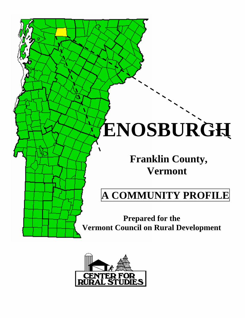
ENOSBURGH
Franklin County, Vermont A COMMUNITY PROFILE Prepared for the Vermont Council on Rural Development
ENOSBURGH
Franklin County, Vermont
A Community Profile
Prepared for the
Vermont Council on Rural Development Community Visit March 24, 2003
By The Center for Rural Studies
207 Morrill Hall University of Vermont
A Note to the Reader Just as a community is never finished modifying, adapting, and organizing its natural, political, and social environments, an attempt to profile those dynamic processes must be a work in progress. Materials below are organized to reflect community characteristics and resources. Please join us in this profiling effort and call attention to major omissions, inaccuracies, and errors of fact. The Center for Rural Studies' Community Profile Series is supported, in part, by annual allotments of competitive Hatch Funds from the University of Vermont Agricultural Experiment Station, and USDA's CSREES (Cooperative State Research, Education, and Extension Service). The ongoing support and attention of Senator Patrick Leahy and his staff is greatly appreciated. Thank you, Fred Schmidt, Co-Director Chip Sawyer, Research Data Specialist Michael Moser, UVM Graduate Student The Center for Rural Studies University of Vermont Website: http://crs.uvm.edu Phone: (802) 656-3021 Email: [email protected]

Table of Contents Section 1. Town Organization................................................................................page 1 Section 2. Human Resources ..................................................................................page 3 Section 3. Business and Infrastructure Resources ...............................................page 7 Section 4. Education................................................................................................page 9 Section 5. Sources....................................................................................................page 12 Tables Table 1.1 General Town Characteristics ...............................................................page 2 Table 1.2 General Planning Characteristics..........................................................page 2 Table 1.3 Civic History ............................................................................................page 3 Table 2.1 Population Characteristics .....................................................................page 4 Table 2.2 Age and Gender Demographic Comparisons .......................................page 4 Table 2.3 Housing and Family Characteristics .....................................................page 5 Table 2.4 Income & Poverty Comparisons............................................................page 6 Table 3.1 Employment Characteristics..................................................................page 7 Table 3.2 Annual Average Unemployment Rate...................................................page 8 Table 3.3 Property Valuation and Taxation..........................................................page 8 Table 3.4 Local Transportation Behavior .............................................................page 9 Table 4.1 General School Information...................................................................page 10 Table 4.2 Elementary and Secondary Public School Enrollment........................page 10 Table 4.3 Educational Attainment..........................................................................page 11
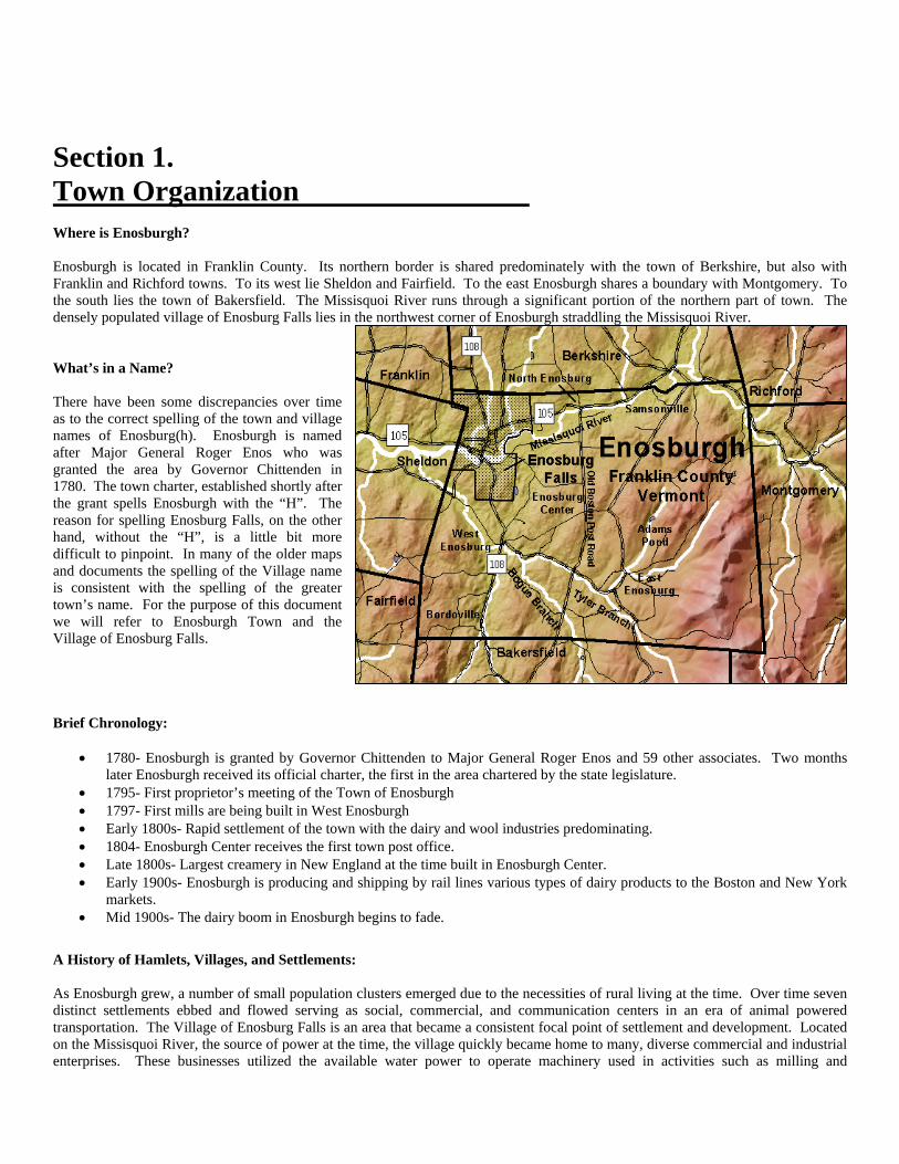
Section 1. Town Organization Where is Enosburgh? Enosburgh is located in Franklin County. Its northern border is shared predominately with the town of Berkshire, but also with Franklin and Richford towns. To its west lie Sheldon and Fairfield. To the east Enosburgh shares a boundary with Montgomery. To the south lies the town of Bakersfield. The Missisquoi River runs through a significant portion of the northern part of town. The densely populated village of Enosburg Falls lies in the northwest corner of Enosburgh straddling the Missisquoi River. What’s in a Name? There have been some discrepancies over time as to the correct spelling of the town and village names of Enosburg(h). Enosburgh is named after Major General Roger Enos who was granted the area by Governor Chittenden in 1780. The town charter, established shortly after the grant spells Enosburgh with the “H”. The reason for spelling Enosburg Falls, on the other hand, without the “H”, is a little bit more difficult to pinpoint. In many of the older maps and documents the spelling of the Village name is consistent with the spelling of the greater town’s name. For the purpose of this document we will refer to Enosburgh Town and the Village of Enosburg Falls. Brief Chronology:
• 1780- Enosburgh is granted by Governor Chittenden to Major General Roger Enos and 59 other associates. Two months later Enosburgh received its official charter, the first in the area chartered by the state legislature.
• 1795- First proprietor’s meeting of the Town of Enosburgh • 1797- First mills are being built in West Enosburgh • Early 1800s- Rapid settlement of the town with the dairy and wool industries predominating. • 1804- Enosburgh Center receives the first town post office. • Late 1800s- Largest creamery in New England at the time built in Enosburgh Center. • Early 1900s- Enosburgh is producing and shipping by rail lines various types of dairy products to the Boston and New York
markets. • Mid 1900s- The dairy boom in Enosburgh begins to fade.
A History of Hamlets, Villages, and Settlements: As Enosburgh grew, a number of small population clusters emerged due to the necessities of rural living at the time. Over time seven distinct settlements ebbed and flowed serving as social, commercial, and communication centers in an era of animal powered transportation. The Village of Enosburg Falls is an area that became a consistent focal point of settlement and development. Located on the Missisquoi River, the source of power at the time, the village quickly became home to many, diverse commercial and industrial enterprises. These businesses utilized the available water power to operate machinery used in activities such as milling and
manufacturing. Sampsonville, also known as the Upper Falls developed as a prosperous hamlet when a small dam was built. Several businesses sprang up along the banks of the Missisquoi to take advantage of the water power available there. Times change, and many of old dams marking the industrial era of the area have washed away leaving only a footprint of its history along the riverbanks. The hamlet of Bordoville is one place that developed out of the necessity for accessible services in a pre-automobile economy. Located in the southwest corner of Enosburgh off of Route 108, this once isolated hamlet featured its own post office, school, church, and grocery store. Bordoville offers beautiful views of the surrounding mountains including Jay Peak, Mount Mansfield, and Cold Hollow Mountain in Bakersfield. Located in East Enosburgh on the Eastern slope of Enosburgh Mountain, the hamlet of Hillwest existed in isolation from the rest of Enosburgh. The farmers that carved out a living here considered themselves to be from Montgomery more than from Enosburgh. These days the once abundant fields have grown back into forestlands leaving only remnants of the farming community that once settled this area. Government and Civic Structure:
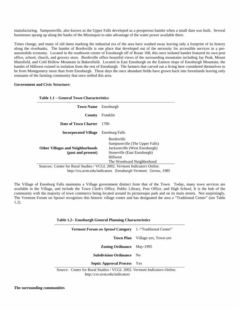
Table 1.1 – General Town Characteristics
Town Name Enosburgh
County Franklin
Date of Town Charter 1780
Incorporated Village Enosburg Falls
Other Villages and Neighborhoods (past and present)
Bordoville Sampsonville (The Upper Falls) Jacksonville (West Enosburgh) Stoneville (East Enosburgh) Hillwest The Woodward Neighborhood
Sources: Center for Rural Studies / VCGI. 2002. Vermont Indicators Online. http://crs.uvm.edu/indicators Enosburgh Vermont. Geraw, 1985
The Village of Enosburg Falls maintains a Village government distinct from that of the Town. Today, many town services are available in the Village, and include the Town Clerk's Office, Public Library, Post Office, and High School, It is the hub of the community with the majority of town commerce being located around its picturesque park and on its main streets. Not surprisingly, The Vermont Forum on Sprawl recognizes this historic village center and has designated the area a “Traditional Center” (see Table 1.2).
The surrounding communities
Table 1.2– Enosburgh General Planning Characteristics
Vermont Forum on Sprawl Category 1 -“Traditional Center”
Town Plan Village-yes, Town-yes
Zoning Ordinance May-1995
Subdivision Ordinance No
Septic Approval Process Yes Source: Center for Rural Studies / VCGI. 2002. Vermont Indicators Online. http://crs.uvm.edu/indicators
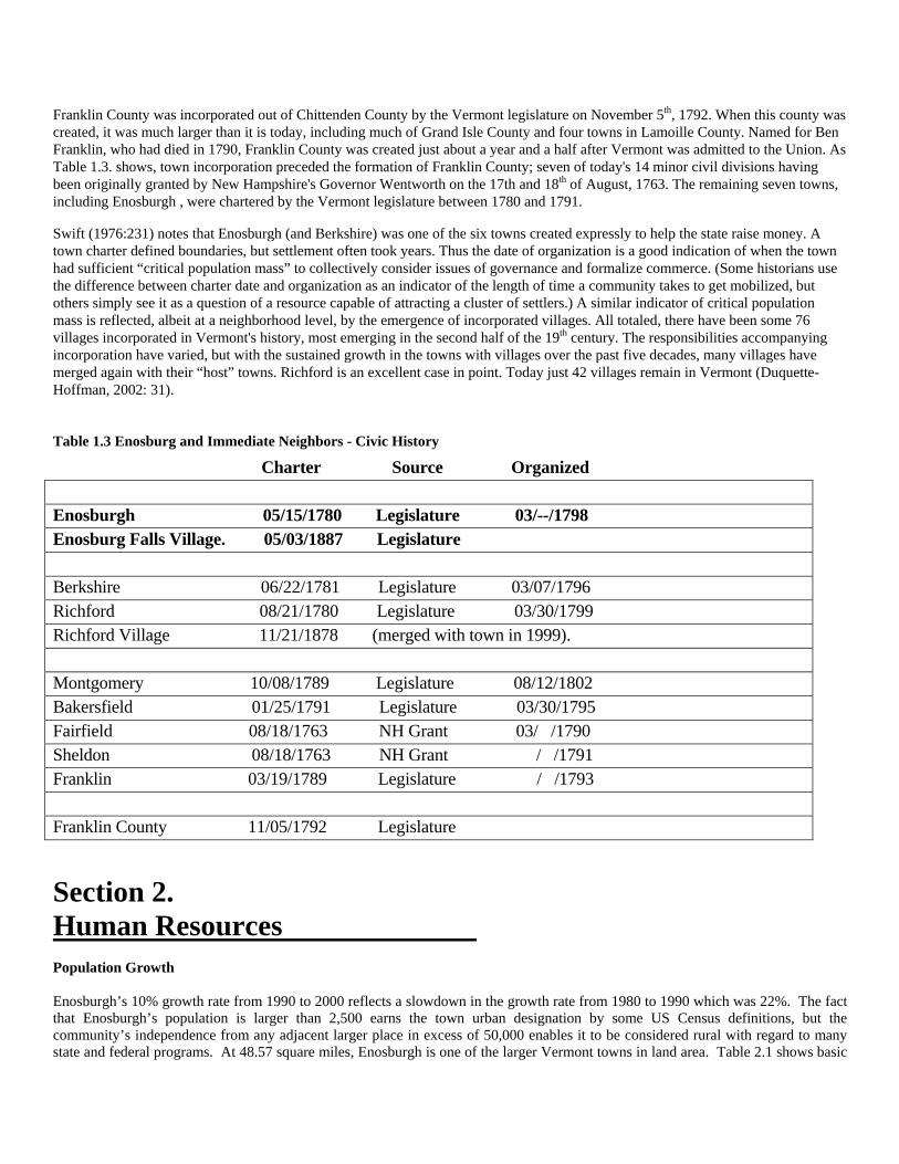
Franklin County was incorporated out of Chittenden County by the Vermont legislature on November 5th, 1792. When this county was created, it was much larger than it is today, including much of Grand Isle County and four towns in Lamoille County. Named for Ben Franklin, who had died in 1790, Franklin County was created just about a year and a half after Vermont was admitted to the Union. As Table 1.3. shows, town incorporation preceded the formation of Franklin County; seven of today's 14 minor civil divisions having been originally granted by New Hampshire's Governor Wentworth on the 17th and 18th of August, 1763. The remaining seven towns, including Enosburgh , were chartered by the Vermont legislature between 1780 and 1791.
Swift (1976:231) notes that Enosburgh (and Berkshire) was one of the six towns created expressly to help the state raise money. A town charter defined boundaries, but settlement often took years. Thus the date of organization is a good indication of when the town had sufficient “critical population mass” to collectively consider issues of governance and formalize commerce. (Some historians use the difference between charter date and organization as an indicator of the length of time a community takes to get mobilized, but others simply see it as a question of a resource capable of attracting a cluster of settlers.) A similar indicator of critical population mass is reflected, albeit at a neighborhood level, by the emergence of incorporated villages. All totaled, there have been some 76 villages incorporated in Vermont's history, most emerging in the second half of the 19th century. The responsibilities accompanying incorporation have varied, but with the sustained growth in the towns with villages over the past five decades, many villages have merged again with their “host” towns. Richford is an excellent case in point. Today just 42 villages remain in Vermont (Duquette-Hoffman, 2002: 31).
Table 1.3 Enosburg and Immediate Neighbors - Civic History
Charter Source Organized Enosburgh 05/15/1780 Legislature 03/--/1798 Enosburg Falls Village. 05/03/1887 Legislature Berkshire 06/22/1781 Legislature 03/07/1796 Richford 08/21/1780 Legislature 03/30/1799 Richford Village 11/21/1878 (merged with town in 1999). Montgomery 10/08/1789 Legislature 08/12/1802 Bakersfield 01/25/1791 Legislature 03/30/1795 Fairfield 08/18/1763 NH Grant 03/ /1790 Sheldon 08/18/1763 NH Grant / /1791 Franklin 03/19/1789 Legislature / /1793 Franklin County 11/05/1792 Legislature
Section 2. Human Resources Population Growth Enosburgh’s 10% growth rate from 1990 to 2000 reflects a slowdown in the growth rate from 1980 to 1990 which was 22%. The fact that Enosburgh’s population is larger than 2,500 earns the town urban designation by some US Census definitions, but the community’s independence from any adjacent larger place in excess of 50,000 enables it to be considered rural with regard to many state and federal programs. At 48.57 square miles, Enosburgh is one of the larger Vermont towns in land area. Table 2.1 shows basic
demographic data from both the Town of Enosburgh and the Village of Enosburg Falls. All Town of Enosburgh data in this report includes the Village of Enosburg Falls (a pattern established by federal reporting).
Table 2.1 – Population Characteristics Enosburgh Enosburg Falls
Total Population, 2000 2,788 1,473
Total Population, 1990 2,535 1,350 Absolute Population Change, 1990 – 2000 253 people 123 people Percent Population Change, 1990 – 2000 10% 8.4%
Persons per Square Mile, 2000 57.4 NA Persons per Square Mile, 1990 52.2 NA
Area in Square Miles 48.57 NA
Percent Dependent, 2000 (under 18 and over 65) .42% NA
Percent Rural, 2000 100% NA Percent Rural Farm, 2000 2.4% NA
Population Reporting Native Birth (United States), 2000
2682 NA
Population Reporting French/French Canadian Ancestry, 2000 882 NA
Sources: Center for Rural Studies / VCGI. 2002. Vermont Indicators Online. http://crs.uvm.edu/indicators US Census Bureau. 1990, 2000. American FactFinder. http://factfinder.census.gov Age and Gender of Enosburgh’s Citizens
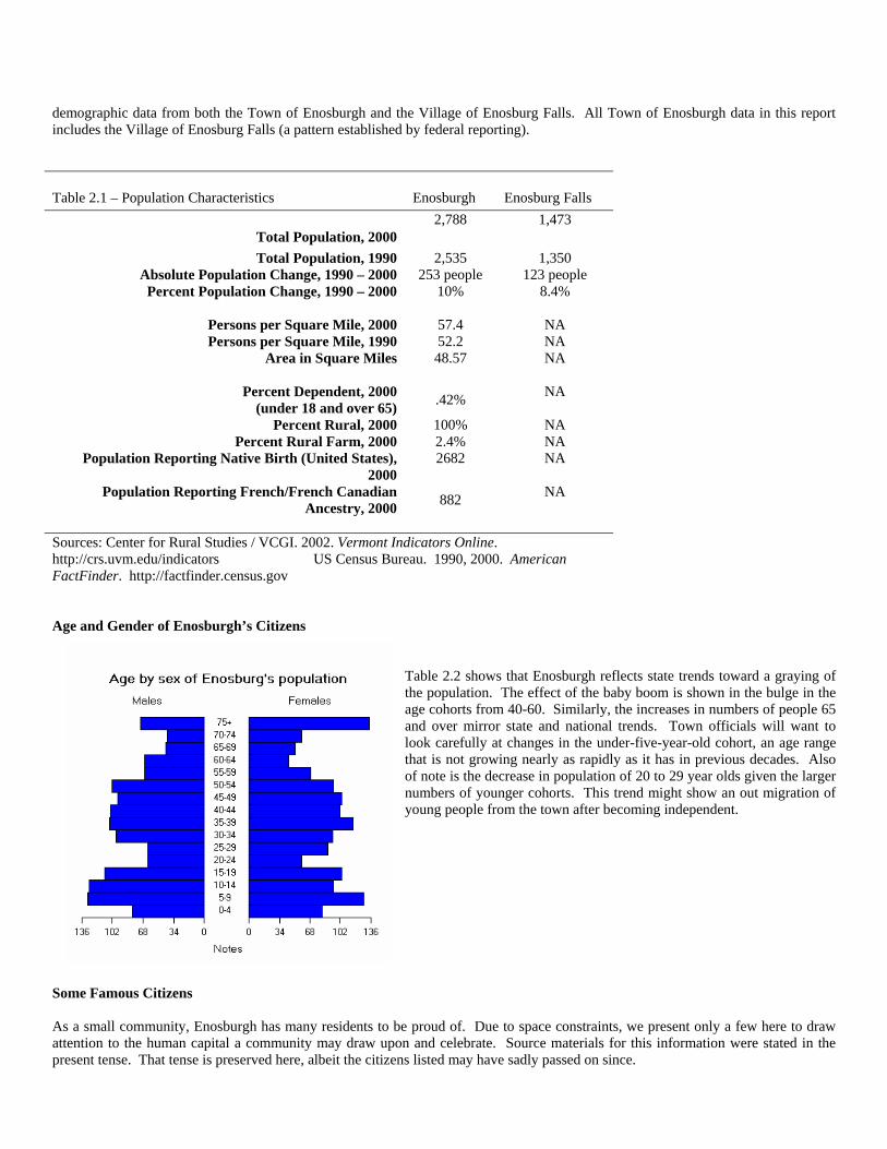
Table 2.2 shows that Enosburgh reflects state trends toward a graying of the population. The effect of the baby boom is shown in the bulge in the age cohorts from 40-60. Similarly, the increases in numbers of people 65 and over mirror state and national trends. Town officials will want to look carefully at changes in the under-five-year-old cohort, an age range that is not growing nearly as rapidly as it has in previous decades. Also of note is the decrease in population of 20 to 29 year olds given the larger numbers of younger cohorts. This trend might show an out migration of young people from the town after becoming independent.
Some Famous Citizens As a small community, Enosburgh has many residents to be proud of. Due to space constraints, we present only a few here to draw attention to the human capital a community may draw upon and celebrate. Source materials for this information were stated in the present tense. That tense is preserved here, albeit the citizens listed may have sadly passed on since.
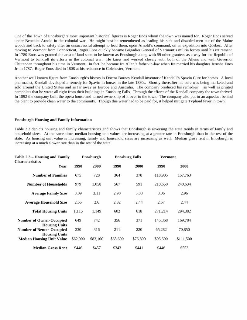
One of the Town of Enosburgh’s most important historical figures is Roger Enos whom the town was named for. Roger Enos served under Benedict Arnold in the colonial war. He might best be remembered as leading his sick and disabled men out of the Maine woods and back to safety after an unsuccessful attempt to lead them, upon Arnold’s command, on an expedition into Quebec. After moving to Vermont from Connecticut, Roger Enos quickly became Brigadier General of Vermont’s militia forces until his retirement. In 1780 Enos was granted the area of land soon to be known as Enosburgh along with 59 other grantees as a way for the Republic of Vermont to bankroll its efforts in the colonial war. He knew and worked closely with both of the Allens and with Governor Chittenden throughout his time in Vermont. In fact, he became Ira Allen’s father-in-law when Ira married his daughter Jerusha Enos Jr. in 1787. Roger Enos died in 1808 at his residence in Colchester, Vermont. Another well known figure from Enosburgh’s history is Doctor Burney Kendall inventor of Kendall’s Spavin Cure for horses. A local pharmacist, Kendall developed a remedy for Spavin in horses in the late 1880s. Shortly thereafter his cure was being marketed and sold around the United States and as far away as Europe and Australia. The company produced his remedies as well as printed pamphlets that he wrote all right from their buildings in Enosburg Falls. Through the efforts of the Kendall company the town thrived. In 1892 the company built the opera house and turned ownership of it over to the town. The company also put in an aqueduct behind the plant to provide clean water to the community. Though this water had to be paid for, it helped mitigate Typhoid fever in town. Enosburgh Housing and Family Information Table 2.3 depicts housing and family characteristics and shows that Enosburgh is reversing the state trends in terms of family and household sizes. At the same time, median housing unit values are increasing at a greater rate in Enosburgh than in the rest of the state. As housing unit value is increasing, family and household sizes are increasing as well. Median gross rent in Enosburgh is increasing at a much slower rate than in the rest of the state. Table 2.3 – Housing and Family Characteristics
Enosburgh Enosburg Falls Vermont
Year 1990 2000 1990 2000 1990 2000
Number of Families 675 728 364 378 118,905 157,763
Number of Households 979 1,058 567 591 210,650 240,634
Average Family Size 3.09 3.11 2.90 3.03 3.06 2.96
Average Household Size 2.55 2.6 2.32 2.44 2.57 2.44
Total Housing Units 1,115 1,149 602 618 271,214 294,382
Number of Owner-Occupied Housing Units
649 742 356 371 145,368 169,784
Number of Renter-Occupied Housing Units
330 316 211 220 65,282 70,850
Median Housing Unit Value $62,900 $83,100 $63,600 $76,800 $95,500 $111,500
Median Gross Rent $446 $457 $343 $441 $446 $553
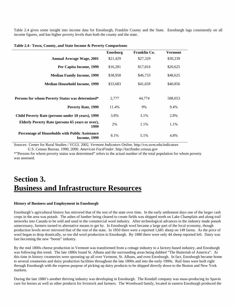
Table 2.4 gives some insight into income data for Enosburgh, Franklin County and the State. Enosburgh lags consistently on all income figures, and has higher poverty levels than both the county and the state.
Section 3. Business and Infrastructure Resources History of Business and Employment in Enosburgh Enosburgh’s agricultural history has mirrored that of the rest of the state over time. In the early settlement days one of the larger cash crops in the area was potash. The ashes of lumber being cleared to create fields was shipped north on Lake Champlain and along trail networks into Canada to be sold and used in the commercial wool industry. After technological advances in the industry made potash unnecessary, farmers turned to alternative means to get by. In Enosburgh wool became a large part of the local economy, though production levels never mirrored that of the rest of the state. In 1850 there were a reported 1,681 sheep on 149 farms. As the price of wool began to drop drastically, so too did wool production in Enosburgh. By 1880 there were only 44 sheep reported left. Dairy was fast becoming the new “boom” industry. By the mid 1800s cheese production in Vermont was transformed from a cottage industry to a factory-based industry, and Enosburgh was following this trend. The late 1880s found St. Albans and the surrounding areas being dubbed “The Buttertub of America”. At this time in history creameries were sprouting up all over Vermont, St. Albans, and even Enosburgh. In fact, Enosburgh became home to several creameries and dairy production facilities throughout the late 1800s and into the early 1900s. Rail lines were built right through Enosburgh with the express purpose of picking up dairy products to be shipped directly down to the Boston and New York markets. During the late 1880’s another thriving industry was developing in Enosburgh. The Kendall company was mass-producing its Spavin cure for horses as well as other products for livestock and farmers. The Woodward family, located in eastern Enosburgh produced the
Table 2.4– Town, County, and State Income & Poverty Comparisons
Enosburg Franklin Co. Vermont Annual Average Wage, 2001 $21,429 $27,329 $30,239
Per Capita Income, 1999 $16,281 $17,816 $20,625
Median Family Income, 1999 $38,958 $46,733 $48,625
Median Household Income, 1999 $33,683 $41,659 $40,856
Persons for whom Poverty Status was determined* 2,777 44,774 588,053
Poverty Rate, 1999 11.4% 9% 9.4%
Child Poverty Rate (persons under 18 years), 1999 3.8% 3.1% 2.8%
Elderly Poverty Rate (persons 65 years or over), 1999 2% 1.1% 1.1%
Percentage of Households with Public Assistance Income, 1999 8.1% 5.1% 4.8%
Sources: Center for Rural Studies / VCGI. 2002. Vermont Indicators Online. http://crs.uvm.edu/indicators U.S. Census Bureau. 1990, 2000. American FactFinder. http://factfinder.census.gov *”Persons for whom poverty status was determined” refers to the actual number of the total population for whom poverty was assessed.
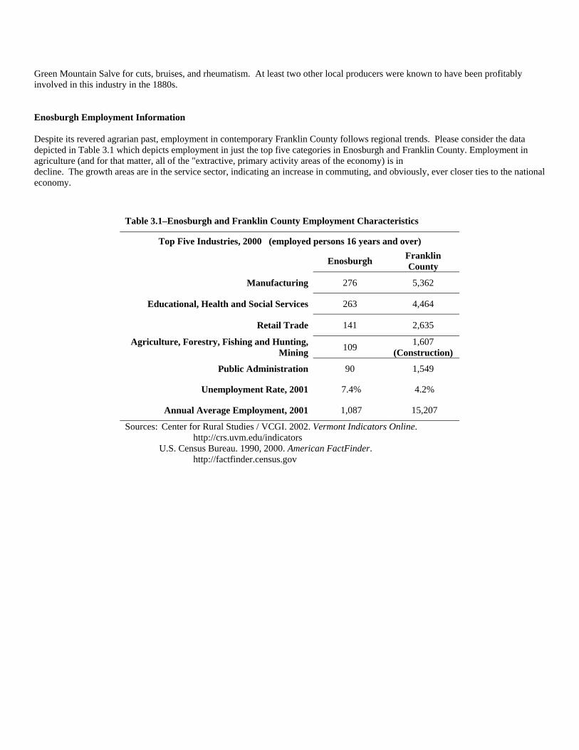
Green Mountain Salve for cuts, bruises, and rheumatism. At least two other local producers were known to have been profitably involved in this industry in the 1880s. Enosburgh Employment Information Despite its revered agrarian past, employment in contemporary Franklin County follows regional trends. Please consider the data depicted in Table 3.1 which depicts employment in just the top five categories in Enosburgh and Franklin County. Employment in agriculture (and for that matter, all of the "extractive, primary activity areas of the economy) is in decline. The growth areas are in the service sector, indicating an increase in commuting, and obviously, ever closer ties to the national economy.
Table 3.1–Enosburgh and Franklin County Employment Characteristics
Top Five Industries, 2000 (employed persons 16 years and over)
Enosburgh Franklin County
Manufacturing 276 5,362
Educational, Health and Social Services 263 4,464
Retail Trade 141 2,635
Agriculture, Forestry, Fishing and Hunting, Mining 109 1,607
(Construction)
Public Administration 90 1,549
Unemployment Rate, 2001 7.4% 4.2%
Annual Average Employment, 2001 1,087 15,207
Sources: Center for Rural Studies / VCGI. 2002. Vermont Indicators Online. http://crs.uvm.edu/indicators U.S. Census Bureau. 1990, 2000. American FactFinder. http://factfinder.census.gov
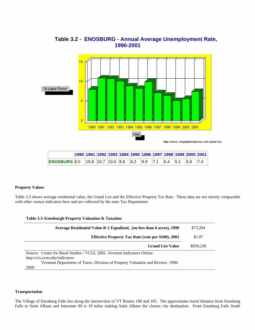
Table 3.2 - ENOSBURG - Annual Average Unemployment Rate, 1990-2001
1990 1991 1992 1993 1994 1995 1996 1997 1998 1999 2000 2001ENOSBURG 8.0 10.8 10.7 10.0 8.8 8.2 9.9 7.1 6.4 5.1 5.6 7.4
Property Values Table 3.3 shows average residential value, the Grand List and the Effective Property Tax Rate. These data are not strictly comparable with other census indicators here and are collected by the state Tax Department.
Table 3.3–Enosburgh Property Valuation & Taxation
Average Residential Value R-1 Equalized, (on less than 6 acres), 1999 $73,204
Effective Property Tax Rate (rate per $100), 2001 $1.87
Grand List Value $939,236
Source: Center for Rural Studies / VCGI. 2002. Vermont Indicators Online. http://crs.uvm.edu/indicators Vermont Department of Taxes, Division of Property Valuation and Review. 1998- 2000
Transportation The Village of Enosburg Falls lies along the intersection of VT Routes 108 and 105. The approximate travel distance from Enosburg Falls to Saint Albans and Interstate 89 is 18 miles making Saint Albans the closest city destination. From Enosburg Falls South
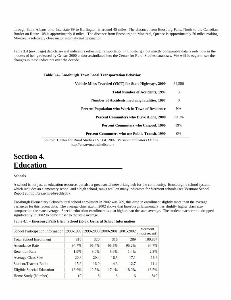
through Saint Albans onto Interstate 89 to Burlington is around 45 miles. The distance from Enosburg Falls, North to the Canadian Border on Route 108 is approximately 8 miles. The distance from Enosburgh to Montreal, Quebec is approximately 70 miles making Montreal a relatively close major international destination. Table 3.4 (next page) depicts several indicators reflecting transportation in Enosburgh, but strictly comparable data is only now in the process of being released by Census 2000 and/or assimilated into the Center for Rural Studies databases. We will be eager to see the changes in these indicators over the decade.
Table 3.4– Enosburgh Town Local Transportation Behavior
Vehicle Miles Traveled (VMT) for State Highways, 2000 34,586
Total Number of Accidents, 1997 3
Number of Accidents involving fatalities, 1997 0
Percent Population who Work in Town of Residence NA
Percent Commuters who Drive Alone, 2000 70.3%
Percent Commuters who Carpool, 1990 19%
Percent Commuters who use Public Transit, 1990 0%
Source: Center for Rural Studies / VCGI. 2002. Vermont Indicators Online. http://crs.uvm.edu/indicators
Section 4. Education Schools A school is not just an education resource, but also a great social networking hub for the community. Enosburgh’s school system, which includes an elementary school and a high school, ranks well on many indicators for Vermont schools (see Vermont School Report at http://crs.uvm.edu/schlrpt/). Enosburgh Elementary School’s total school enrollment in 2002 was 289, this drop in enrollment slightly more than the average variances for this recent data. The average class size in 2002 shows that Enosburgh Elementary has slightly higher class size compared to the state average. Special education enrollment is also higher than the state average. The student teacher ratio dropped significantly in 2002 to come closer to the state average.
Table 4.1 – Enosburg Falls Elem. School (K-6): General School Information
School Participation Information 1998-1999 1999-2000 2000-2001 2001-2002 Vermont (most recent)
Total School Enrollment 316 320 316 289 100,867Attendance Rate 94.7% 95.4% 95.5% 95.2% 94.7%Retention Rate 1.9% 3.0% 5.9% 1.4% 2.3%Average Class Size 20.3 20.4 16.5 17.1 16.6Student/Teacher Ratio 15.9 16.0 14.3 12.7 11.4Eligible Special Education 13.6% 12.5% 17.4% 18.0% 13.5%Home Study (Number) 10 8 5 6 1,819
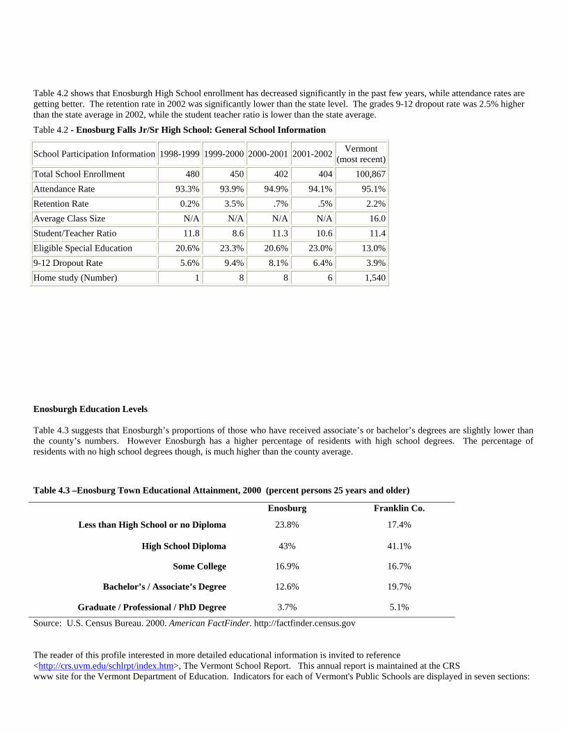
Table 4.2 shows that Enosburgh High School enrollment has decreased significantly in the past few years, while attendance rates are getting better. The retention rate in 2002 was significantly lower than the state level. The grades 9-12 dropout rate was 2.5% higher than the state average in 2002, while the student teacher ratio is lower than the state average.
Table 4.2 - Enosburg Falls Jr/Sr High School: General School Information
School Participation Information 1998-1999 1999-2000 2000-2001 2001-2002 Vermont (most recent)
Total School Enrollment 480 450 402 404 100,867Attendance Rate 93.3% 93.9% 94.9% 94.1% 95.1%Retention Rate 0.2% 3.5% .7% .5% 2.2%Average Class Size N/A N/A N/A N/A 16.0Student/Teacher Ratio 11.8 8.6 11.3 10.6 11.4Eligible Special Education 20.6% 23.3% 20.6% 23.0% 13.0%9-12 Dropout Rate 5.6% 9.4% 8.1% 6.4% 3.9%Home study (Number) 1 8 8 6 1,540 Enosburgh Education Levels Table 4.3 suggests that Enosburgh’s proportions of those who have received associate’s or bachelor’s degrees are slightly lower than the county’s numbers. However Enosburgh has a higher percentage of residents with high school degrees. The percentage of residents with no high school degrees though, is much higher than the county average.
Table 4.3 –Enosburg Town Educational Attainment, 2000 (percent persons 25 years and older)
Enosburg Franklin Co.
Less than High School or no Diploma 23.8% 17.4%
High School Diploma 43% 41.1%
Some College 16.9% 16.7%
Bachelor’s / Associate’s Degree 12.6% 19.7%
Graduate / Professional / PhD Degree 3.7% 5.1%
Source: U.S. Census Bureau. 2000. American FactFinder. http://factfinder.census.gov The reader of this profile interested in more detailed educational information is invited to reference <http://crs.uvm.edu/schlrpt/index.htm>, The Vermont School Report. This annual report is maintained at the CRS www site for the Vermont Department of Education. Indicators for each of Vermont's Public Schools are displayed in seven sections:
1. general information, 2. program information, 3. staff information, 4. more community social indicators, 5. financial resources, 6. financial expenditure and 7. student performance. The Vermont School Report was last updated on February 25, 2003.Also available is the "Complete Vermont Report" which shows state averages and totals for up to four years of data.
Section 5. Sources This Community Profile is an attempt to bring together information from many different sources. The internet resources used include: For data: The Center for Rural Studies. 2002. Vermont Indicators Online. http://crs.uvm.edu/indicators/ The U.S. Census Bureau. 2002. American FactFinder. http://factfinde.census.gov Vermont Dept. of Education. 2002. Vermont School Report. http://maps.vcgi.org/schlrpt/ For text: Virtual Vermont. 2002. http://www.virtualvermont.com/towns/enosburg.html Secretary of State's internet site 2002. <http://www.sec.state.vt.us/search/secsearch.html> For maps: http://www.mapquest.com The written sources used were: Bearse, Ray - editor 1966 Vermont: A Guide to the Green Mountain State, The New American Guide Series, Second Edition, Revised and Enlarged. Boston, Houghton Mifflin Company. Duquette-Hoffman, Jason 2002. The Rise, Decline and Emerging rebirth of the Vermont Village, MS Thesis, Community Development and Applied Economics, University of Vermont. Geraw, Janice 1985. Enosburgh Vermont. Enosburgh, Vermont. The Enosburgh Historical Society, inc. Swift, Esther Munroe 1977 Vermont Place-Names: Footprints of History. Brattleboro, Vermont. The Stephen Greene Press. Center for Rural Studies files: Enosburgh packet from 1980.