establishment of the ecological network in vojvodina
TRANSCRIPT
Establishment of the Ecological
Network in Vojvodina
Klara Szabados
Institute for Nature Conservation of Vojvodina Province

1. Economical importance of the nature conservation
2. Land use and biodiversity in the biogeographical
regions of Serbia
3. Ecological network as a conservation tool
4. Ecological network in Europe
5. Ecological network in Serbia
6. Design of the ecological network in Vojvodina
7. Integrating the ecological network into the
development of the region:
1. Spatial planning
2. Sustainable use and protection of the natural resources
Economical importance of the nature conservation
- Convention on biological diversity (CBD,1992) underlines the
importance of the biological diversity for the life sustaining systems of the
biosphere.
- Decline of ecosystem services (including the regeneration of the renewable
natural resources and climate regulation) are linked to the biodiversity
losses (Millennium Ecosystem Assessment, 2005).
- Biodiversity conservation is a part of the activities that ensure the protection
of the natural capital (stock of natural resources). Nature conservation is one
of the tools regulating the sustainable use of natural resources (Law on the
nature protection, 2009/10)
- Biodiversity is recognised as a natural resource (Strategy on the sustainable use
of the natrural resources in Serbia, 2012)
- Some parts of Serbia belongs to the most diverse regions of the Earth
(IUCN)

Biographical regions in Serbia
North Serbia: Pannonian biogeographical region
Central and South Serbia:Continental biogeographical region
High mountains:Alpine biogeographical region

Land use and biodiversity
Vojvodina:
Agricultural region, 78% arable land
The habitats are fragmented, small and
embedded into cultural landscape,
Central and Southern Serbia
Mountain region, arable land mostly in river
walleys
Species rich mountain pastures, created by
deforestation
Large pristine areas, high number of endemic
species, biodiversity hot-spot on Balkan
penninsula
Source: www.lib.utexas.edu

Biodiversity of agricultural landscapes
Within agricultural areas
Rare and endangered species (protected by national law and international conventions)
survived in the small habitat fragments
Rare and endangered habitat types, listed in the Annex I of Directive 92/43/EEC (Habitat
Directive) are registered in agricultural areas eg. most of the pastures in Vojvodina belong to
Pannonic loess steppic grasslands or Pannonic salt steppes and salt marshes habitat types.
distribution of
ctitically endangered
plant species
Areas of international
conservation values
for birds, plants and
butterflies
PROTECTED
AREAS in 2005

Habitat loss and fragmentation
Most of the natural ecosystems in Europe are destroyed, nature conservation is
focused on the protection of the isolated remains of the natural habitats.
Millennium Ecosystem Assessment, 2005
• The remains of the natural
habitats (pastures and wetlands)
are embedded into cultural
landscape
• The isolated habitat fragments are
only small parts of the former
functional units
• How to ensure the long-term
conservation of theese remains?

Ecological network as a conservation tool
Ecological networks ensures the functional connectivity of the fragmented
natural habitats, essential for the maintaining ecological processess in
areas significantly changed by human activities.
CORRIDORS
CORE AREAS
BUFFER
ZONE

Ecological corridors in Europe
- Most of the ecological corridors
in the developed countries are
destroyed or heavily damaged
-– the reconstruction is expensive,
- Conservation is focused on the
corridor protection nd restoration
betwen the most important
protected areas > regional
projects

Protection of migration routes
Modification of the bridge creates an uderpass for the wildlife – ensure the continuity of the
natural ecological corridor (highway E-75 in Serbia, near Horgoš)
Protection measure of animal species:
• Bern convention ensures the `protection of areas that are of importance for the
migratory species`
• integrated into the Law on nature protection in Serbia
• Bylaw on the technical solution that ensures the safe migration of the wildlife
• Database of the ecological corridors can be used during the planning to decrease
the costs of the construction.

Ecological network in Europe

Ecological networks of our neigbours
NATURA 2000 Bugarska
The ecological network of Serbia have to
be connected with the national networks of
the sorrounding countries

Ecological network in Serbia
Elements:
Designated and evaluated protected areas
Sites of Emerald network
IBA - Important Bird Areas
IPА - Important Plant Areas
PBA - Prime Butterfly Areas
Ramsar sites
Habitats of protected species
Protected habitat types
2004/5 designating sites for Emerald network
(Convention on the Conservation of European Wildlife
and Natural Habitats)
2009- 11 Natura 2000 Twinning project
2009 Law on Nature Conservation
definition of ecological network
2010 Bylaw on Ecological Network: core areas and the
international ecological corridors in Serbia
> Natura 2000

Conservation planning
The further planning required a clear overview
& an organised database
basic spatial attributes of habitat patches
existing field data, field scatches
distribution of protected and rare species
quantitative characteristics of populations
most important threatening factors
zonation
management activities
In 2009 the project Development of Ecological Network in Vojvodina - Review, analysis
and possibilities was launched.
Low-budget development of database: what is available?
Inadequate quality and quantity of
information for further planning:
limited availability of maps – the
biotic data are connected with field-
scatches
cadastar (1: 10 000 or 1:2500) only
for the protected areas –lack of land
use data
low accuracy of the existing spatial
data > topographical maps on the
scale of 1:25 000
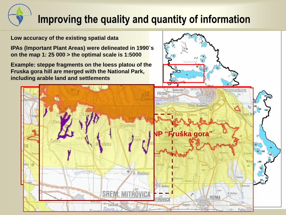
Improving the quality and quantity of information
NP “Fruška gora”
Low accuracy of the existing spatial data
IPAs (Important Plant Areas) were delineated in 1990`s
on the map 1: 25 000 > the optimal scale is 1:5000
Example: steppe fragments on the loess platou of the
Fruska gora hill are merged with the National Park,
including arable land and settlements

PROTECTED AREAS area (ha) Назив I категорија заштите природног добра Површина (ha)
СРП “ДЕЛИБЛАТСКА ПЕШЧАРА” 34,829.32
НП “ФРУШКА ГОРА” 25,393.00
“МОРОВИЋКЕ ШУМЕ” (ревизја) 21,852.00
СРП “ГОРЊЕ ПОДУНАВЉЕ” 19,648.00
area >10 000 ha
СРП “ОБЕДСКА БАРА” 9,820.00
СРП "ТИТЕЛСКИ БРЕГ” (у фази проглашења) 8,197.00
СРП "ОКАЊ БАРА” (у фази проглашења) 5,678.00
ПИО “СУБОТИЧКА ПЕШЧАРА” 5,369.90
СРП “КОВИЉСКО - ПЕТРОВАРАДИНСКИ РИТ” 4,840.61
ПИО “ВРШАЧКЕ ПЛАНИНЕ” 4,371.00
СРП “КАРАЂОРЂЕВО” 2,955.33
СРП "СТАРИ БЕГЕЈ - ЦАРСКА БАРА" 1,676.00
ПИО “ЛЕСНЕ ДОЛИНЕ РЕКЕ КРИВАЈЕ” (ревизја) 2,000.00
ПП “ЈЕГРИЧКА” 1,144.00
1000 ha < area <10 000 ha
СРП “ПАШЊАЦИ ВЕЛИКЕ ДРОПЉЕ” 979.44
СРП "СЛАНО КОПОВО" 976.45
ПП "МАЛИ ВРШАЧКИ РИТ" 931.00
СРП “ЛУДАШКО ЈЕЗЕРО” 846.33
ПП “ ПАЛИЋ И СПОМЕНИЦИ ПРИРОДЕ У ЊЕМУ” 712.90
СРП “СЕЛЕВЕЊСКЕ ПУСТАРЕ” 677.04
СРП “ЗАСАВИЦА” 671.00
ПП “ТИКВАРА” 508.14
ПП "СТАРА ТИСА КОД БИСЕРНОГ ОСТРВА" 391.73
ПП “БЕГЕЧКА ЈАМА” 379.40
ПП “КАМАРАШ” 267.96
СРП “КРАЉЕВАЦ” 264.30
СП “ШУМА ЈУНАКОВИЋ” 180.05
ПП “БЕЉАНСКА БАРА” (у фази проглашења) 173.00
СП “БАРА ТРСКОВАЧА” (у фази проглашења) 168.00
СРП “БАГРЕМАРА” 117.58
100 ha < area <1000 ha
СП “ХРАСТОВА ШУМА КОД НАСЕЉА СТРАЖА” 67.61
СП “ИВАНОВАЧКА АДА” 6.07
СП “ЧАРНОК” (у фази проглашења) 3.22
СП “ЈУРИШИНА ХУМКА” 0.18
area <100 ha
Protected areas in Vojvodina I
• effects of fragmentation and isolation, unfavorable shape (edge effect, lack of undisturbed habitats)
• the lack of strong correlation between the area and the number of rare/endangered species

Special Nature Reserve
Selevenjske Pustare (677 ha)
10 sub-units, from 6 ha to 123 ha
22 protected plant species
barrier: highway E 75
Cirsium
brachycephalum
Special Nature Reserve
Pastures of Great Bustard
3 sub-units > 4256 ha + 2118 ha + 401ha
Otis tarda
Protected areas in Vojvodina II

Nature protection 1948 – 2006
1948 – 2006 Activities were focused on the evaluation and establishment of protected areas
Conservation priorities: large areas + state ownership
Data sources:
scientific publications + personal communications
personal knowledge & experience
limited availability of maps,
lack of spatial data
Data type:
qualitative floristic
and faunistic data
vegetation research
Results:
underrepresented habitat types
• fragmented habitats (steppe)
• Mosaics of private and state ownerships
• (salt steppes and marshes, rural mosaics)
58%
20%
7%
11%4%
šume
livade i pašnjaci
obrađeno
vodene i močvarnepovršine
ostaloother
wetlands
cultivated
forest
grassland

Inventory of habitat patches
Natural or semi-natural habitat patches where one or more protected species were
detected during the last decade > identifyed as a polygon (Google Earth image)
code (county and number)
site name
spatial characteristics (area and perimeter)
detected species at the site
(national level + Bern convention)
main habitat types (in accordance with
Emerald system)
3-7 threatening factors (list of 49 factors)
Inventory data:
481 polygons were registered, based
on the existing field data

Data analysis: habitats Habitat types frequency (%)
Salt steppes and salt marshes 34,72%
Loess steppic grasslands 19,13%
Rural mosaics 16,42%
Humid meadows 15,59%
Tall tree plantations 15,59%
Temperate riverine and swamp forests and brush
14,97%
Marshes 13,93%
Water-fringe vegetation 13,93%
Broad-leaved deciduous forests 12,27%
Extensive cultivation 11,43%
Ditches and small canals 8,94%
Fish ponds 5,82%
Small woodlots 5,82%
Rivers and streams 5,41%
Sand, clay and kaolin quarries 3,53%
Reservoirs 3,33%
sand steppes 2,49%
Permanent freshwater ponds and lakes
2,49%
Industrial lagoons and ornamental ponds
1,87%
Pannonic wooded steppes 1,87%
Navigable canals 1,66%
Lowland blanket bogs 1,04%
27 habitat categories:
natural,
semi-natural (hayfields, pastures)
antropogenic
in the 481 polygons 1030 habitat patches were registered
the high frequency of salt and steppic habitats indicate insufficient conservation status
high proportion of registered antropogenic habitats is resulted by landscape changes
Water reservoirs, quarries and ditches became an important habitat for amphibians, reptilians, invertebrates and birds
the high frequency of salt and steppic habitats indicate insufficient conservation status
high proportion of registered antropogenic habitats is resulted by landscape changes
Water reservoirs, quarries and ditches became an important habitat for amphibians, reptilians, invertebrates and birds
the high frequency of salt and steppic habitats indicate insufficient conservation status
high proportion of registered antropogenic habitats is resulted by landscape changes
Water reservoirs, quarries and ditches became an important habitat for amphibians, reptilians, invertebrates and birds

Importance of anthropogenic habitats: case study Breeding populations of endangered birds species nesting on fish-ponds in Serbia
1 10 100 1000 10000
Ражањ (Plegadis falcinellus)
Лабуд грбац (Cygnus olor)
Сива гуска (Anser anser)
Властелица (Himantopus himantopus)
Букавац (Botaurus stellaris)
Кашичар (Platalea leucorodia)
Еја мочварица (Circus aeruginosus)
Сабљарка (Recurvirostra avosetta)
Патка њорка (Aythya nyroca)
Велика бела чапља (Egretta alba)
Риђоглава патка (Aythya ferina)
Мали вранац (Phalacrocorax pygmeus)
Мала бела чапља (Egretta garzetta)
Мрка чапља (Ardea purpurea)
Велики вранац (Phalacrocorax carbo)
Белобрка чигра (Chlidonias hybrida)
Ћубасти гњурац (Podiceps cristatus)
Гак (Nycticorax nycticorax)
0% 10% 20% 30% 40% 50% 60% 70% 80% 90% 100%
Национална гнездећа популација (парова) % националне популације који се гнезди на рибњацимаNumber of breeding pairs % of breeding population in Serbia

Threatening factors – analisys of all habitat types
0% 10% 20% 30% 40% 50% 60% 70% 80%
predation by domestic animals
other changes of water regime
water pollution from diffuse sources
inappropriate burning of vegetation
lack of traditional land use
drainage system
agriculture within the site
agriculture in vicinity
invasive species
Protected Areas Habitat patches
Effects that could be reduced by well-designed buffer zone
Effects that need a very wide buffer or regulation by transition zone

Corridor identification
Corridor contains the habitat types of core area
grasslands are present in 60% of polygons > connecting
natural habitats protecting the less valuable pastures
39% of the polygons contain forest or steppe/forest habitats >
the corridors are the forest strips and hedges
83% of the polygons include wetland habitats,
river corridors

Potential Natura sites in the national ecological network
Заштићена подручја
У процесу заштите
Станишта заштићених
врста

2010 Regional corridors in Vojvodina have been defined by Regional Spatial Plan
of APV
Local ecological corridors, as well as the habitats of protected species have been
defined by the local spatial plans
Results and applications

Integrating the ecological network into the
development activities: Spatial planning – local
plans

Spatial plan of the
multifunctional ecological
corridor of the river Tisa
increasing investment in the
development of nautical
tourism is expected,
followed by intensified use of
the riverbank area, as well
as the accompanying
infrastructure,
Biodiversity evaluation for
the spatial plan
to ensure the sustainable
use of this environmentaly
sensitive area.
Integrating the ecological network into the development
activities: Spatial planning –special plans

Riparian corridors – riparian buffer (Water Framework Directive)
- erosion controll (Spatial Plan of Serbia and Law on Agriculture:
measures of agricultural land protection)
Forest corridors – Forest Management Sertification (e.g. protection of water
bodies by natural forest edges)
Grassland corridors - erosion controll windbrakes with grassland strips
- game management
(Spatial Plan of Serbia)
Integrating the ecological network into the development of the
region: sustainable use and protection of the natural resources
Project:
Sustainable use of the areas of the ecological network in Autonomous Province of Vojvodina
What is the legal base (laws, bylaws and strategies) for the cooperation?
What are the needs of the local communities (Local Spatial Plans> green areas,
areas for recreation )

Sustainable use and protection of the natural resources

Multifunctional corridors I : water quality improvement
The system of meliorative canals
has a function of ecological
corridors.
Meliorative canals are polluted by
chemicals and nutrients leaching
from the surrounding fields.
Protection or creation of vegetation
strips along the canal banks
improves the water quality. Corridor > buffer strip for water quality protection
removed
N %
grass grass + trees
+ shrubs
50 16 m 5m
75 47m 20m
90 90m 47m

0
5
10
15
20
25
30макс мин просек
I II III IV V VI VII VIII IX X XI XII
Windshelters of comlexs structure provide not only protection from wind and water erosion, but:
> corridors for the species of forest-steppe habitats
> habitats for the species of agricultural landscape (pollinators, insects, birds of prey)
10 years average of wind intensity on Backa loess platou
Multifunctional corridors II: erosion & pest controll

e- mail: [email protected]
http://www.pzzp.rs
MAPS: D. Čalakić, N. Mihajlović, L. Marinković
PHOTOS: Csipe T., Gergely J., Lukács S., Molnár Á.,
Szabados K., Szekeres L., Szekeres O.