experimentalsetup - github pages
TRANSCRIPT
1
El Mendili Lamiae a, Chougrad Mehdi a, Sebari Imane a, Puissant Anne b
a Cartography?Photogrammetry department, School of Geomatics and Surveying Engineering, Hassan II Institute of Agronomy and Veterinary Medicine
b Image City Environment Lab University of Strasbourg
[email protected], [email protected], [email protected] , [email protected]
Int r oduct ion 2 EXPERIMENTAL SETUP
3 Resul t s
Gather ing information about the surface of the earth and particularly its urban component is one of the core fields of remote sensing. The acquired data allows for a better understanding of our living space and usually supports the decision-making process in numerous domains. The complexity of the urban fabric, paired with environmental and socioeconomic challenges has made enhancing our knowledge base about urban forms an increasingly urgent task. Our main objective through this work is to test deep learning methods for urban fabric mapping and for the recognition and the monitoring of urban forms. The contr ibutions of this work can be summarized as follows :
URBAN FABRIC SEGMENTATION ON HIGH RESOLUTION SATELLITE IMAGES USING FULLY CONVOLUTIONAL NEURAL NETWORKS
The metric used to evaluate the score of our training was the Dice Coefficient. The loss was set to the opposite of the dice coefficient. We present below the learning curve of our models during training for both the training set and the development set.
FCN- 32s UNet
FCN- 16s SegNet
As shown below, the UNet architecture achieved the best results converging towards a dice coefficient of approximately 0.85 for both the training set and the development set .
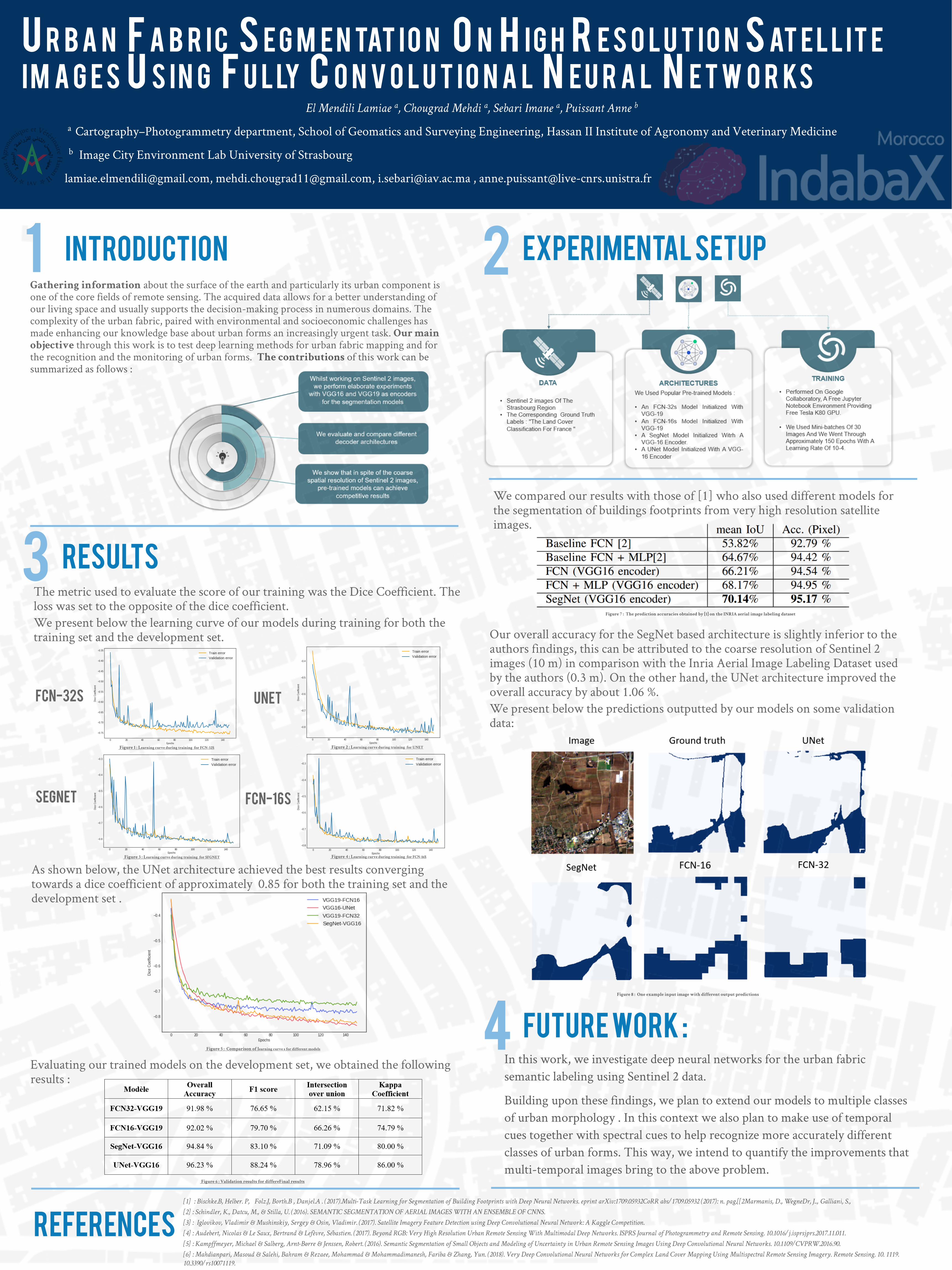
We compared our results with those of [1] who also used different models for the segmentation of buildings footprints from very high resolution satellite images.
Our overall accuracy for the SegNet based architecture is slightly inferior to the authors findings, this can be attributed to the coarse resolution of Sentinel 2 images (10 m) in comparison with the Inria Aerial Image Labeling Dataset used by the authors (0.3 m). On the other hand, the UNet architecture improved the overall accuracy by about 1.06 %. We present below the predictions outputted by our models on some validation data:
REFERENCES[1] : Bischke.B, Helber. P, Folz.J, Borth.B , Danjel.A . (2017).Multi-Task Learning for Segmentation of Building Footprints with Deep Neural Networks. eprint arXiv:1709.05932CoRR abs/ 1709.05932 (2017): n. pag.[[2Marmanis, D., WegneDr, J.., Galliani, S.,
[2] : Schindler, K., Datcu, M., & Stilla, U. (2016). SEMANTIC SEGMENTATION OF AERIAL IMAGES WITH AN ENSEMBLE OF CNNS.
[3] : Iglovikov, Vladimir & Mushinskiy, Sergey & Osin, Vladimir. (2017). Satellite Imagery Feature Detection using Deep Convolutional Neural Network: A Kaggle Competition.
[4] : Audebert, Nicolas & Le Saux, Bertrand & Lefèvre, Sébastien. (2017). Beyond RGB: Very High Resolution Urban Remote Sensing With Multimodal Deep Networks. ISPRS Journal of Photogrammetry and Remote Sensing. 10.1016/ j.isprsjprs.2017.11.011.
[5] : Kampffmeyer, Michael & Salberg, Arnt-Børre & Jenssen, Robert. (2016). Semantic Segmentation of Small Objects and Modeling of Uncertainty in Urban Remote Sensing Images Using Deep Convolutional Neural Networks. 10.1109/ CVPRW.2016.90.
[6] : Mahdianpari, Masoud & Salehi, Bahram & Rezaee, Mohammad & Mohammadimanesh, Fariba & Zhang, Yun. (2018). Very Deep Convolutional Neural Networks for Complex Land Cover Mapping Using Multispectral Remote Sensing Imagery. Remote Sensing. 10. 1119. 10.3390/ rs10071119.
Evaluating our trained models on the development set, we obtained the following results :
4 Fut ur e Wor k :In this work, we investigate deep neural networks for the urban fabric semantic labeling using Sentinel 2 data.
Building upon these findings, we plan to extend our models to multiple classes of urban morphology . In this context we also plan to make use of temporal cues together with spectral cues to help recognize more accurately different classes of urban forms. This way, we intend to quantify the improvements that multi-temporal images bring to the above problem.
Figure 1 : Learning curve dur ing training for FCN-32S Figure 2 : Learning curve dur ing training for UNET
Figure 3 : Learning curve dur ing training for SFGNET Figure 4 : Learning curve dur ing training for FCN-16S
Figure 5 : Compar ison of learning curve s for di f ferent models
Figure 6 : Val idation resul ts for di f fereFinal resul ts
Figure 7 : The predict ion accuracies obtained by [1] on the INRIA aer ial image label ing dataset
Figure 8 : One example input image w ith di f ferent output predict ions