faribault county cd-60 viewers report (draft) valuation
TRANSCRIPT
1
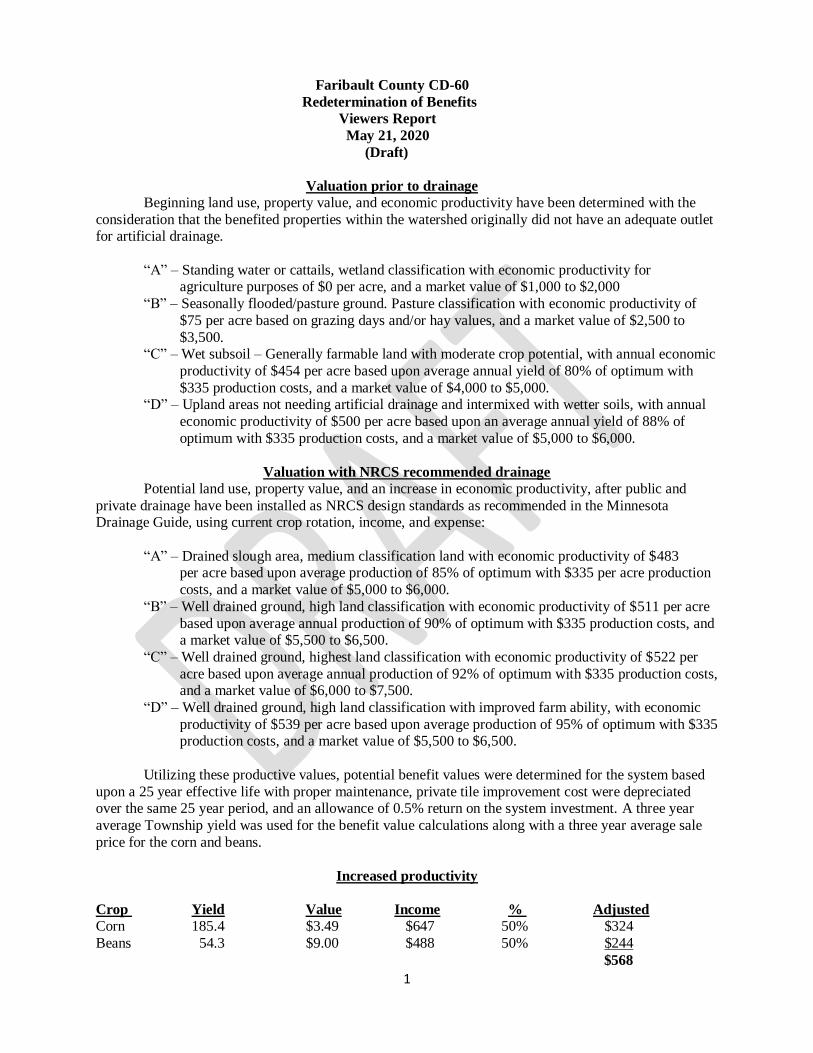
Faribault County CD-60
Redetermination of Benefits
Viewers Report
May 21, 2020
(Draft)
Valuation prior to drainage
Beginning land use, property value, and economic productivity have been determined with the
consideration that the benefited properties within the watershed originally did not have an adequate outlet for artificial drainage.
“A” – Standing water or cattails, wetland classification with economic productivity for agriculture purposes of $0 per acre, and a market value of $1,000 to $2,000
“B” – Seasonally flooded/pasture ground. Pasture classification with economic productivity of
$75 per acre based on grazing days and/or hay values, and a market value of $2,500 to
$3,500. “C” – Wet subsoil – Generally farmable land with moderate crop potential, with annual economic
productivity of $454 per acre based upon average annual yield of 80% of optimum with
$335 production costs, and a market value of $4,000 to $5,000. “D” – Upland areas not needing artificial drainage and intermixed with wetter soils, with annual
economic productivity of $500 per acre based upon an average annual yield of 88% of
optimum with $335 production costs, and a market value of $5,000 to $6,000.
Valuation with NRCS recommended drainage
Potential land use, property value, and an increase in economic productivity, after public and
private drainage have been installed as NRCS design standards as recommended in the Minnesota Drainage Guide, using current crop rotation, income, and expense:
“A” – Drained slough area, medium classification land with economic productivity of $483 per acre based upon average production of 85% of optimum with $335 per acre production
costs, and a market value of $5,000 to $6,000.
“B” – Well drained ground, high land classification with economic productivity of $511 per acre
based upon average annual production of 90% of optimum with $335 production costs, and a market value of $5,500 to $6,500.
“C” – Well drained ground, highest land classification with economic productivity of $522 per
acre based upon average annual production of 92% of optimum with $335 production costs, and a market value of $6,000 to $7,500.
“D” – Well drained ground, high land classification with improved farm ability, with economic
productivity of $539 per acre based upon average production of 95% of optimum with $335 production costs, and a market value of $5,500 to $6,500.
Utilizing these productive values, potential benefit values were determined for the system based
upon a 25 year effective life with proper maintenance, private tile improvement cost were depreciated over the same 25 year period, and an allowance of 0.5% return on the system investment. A three year
average Township yield was used for the benefit value calculations along with a three year average sale
price for the corn and beans.
Increased productivity
Crop Yield Value Income % Adjusted Corn 185.4 $3.49 $647 50% $324
Beans 54.3 $9.00 $488 50% $244
$568

2
Production costs
Corn $474 X 50% = $237
Beans $196 X 50% = $98
$335
Potential Benefit value
“A” “B” “C” “D” 85% of $568 90% of $568 92% of $568 95% of $568
$483 $511 $522 $539
Minus cost
of production $335 $335 $335 $335
Net income $148 $176 $188 $205
Previous income $0 $75 $120 $165 Increased income $148 $101 $68 $40
Private tile costs $56 $31 $27 $18
Annual increase $92 $70 $41 $22
Capitalized for
25 years @ ½ % $2,158 $1,651 $964 $510
% of potential
Benefit 40% 45% 50% 75%
Reduced benefit
Value $863 $743 $482 $382
The potential benefit values have been reduced to reflect a less than optimum yield
Summary
Faribault County CD-60 consists of 2,276.40 acres of farmland, building sites, railroad, and roads, with benefits of $1,434,311
a. 2,189.10 acres of farmland and building sites in Faribault County in JoDaviess Township
b. 15.90 acres of railroad d. 71.40 acres of County and Township roads
e. 2,276.40 total acres
Average land benefits, (reduced) over a 25 year period are $618 per acre
a. A soil $863
b. B soil $743
c. C soil $482 d. D soil $382
Building site benefits a. (Average of B + C + D soils) X 1.5 = $804
Wetland benefits
a. Documented permanent wetland benefits = (Average land benefit) X 0.1 = $62
3
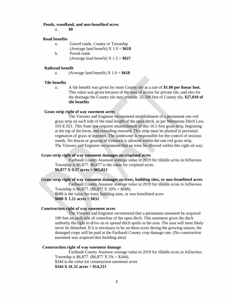
Ponds, woodland, and non-benefited acres
a. $0
Road benefits
a. Gravel roads, County or Township
(Average land benefit) X 1.0 = $618
b. Paved roads
(Average land benefit) X 1.5 = $927
Railroad benefit
a. (Average land benefit) X 1.0 = $618
Tile benefits
a. A tile benefit was given for most County tile at a rate of $1.00 per linear foot.
This value was given because of the ease of access for private tile, and also for
the drainage the County tile may provide. 32,590 feet of County tile, $27,810 of
tile benefits
Grass strip right of way easement acres The Viewers and Engineer recommend establishment of a permanent one rod
grass strip on each side of the total length of the open ditch, as per Minnesota Ditch Law,
103-E.021. This State law requires establishment of this 16.5 foot grass strip, beginning at the top of the berm, and extending outward. This strip must be planted in perennial
vegetation of grass or legumes. The landowner is responsible for the control of noxious
weeds. No fences or grazing of livestock is allowed within the one rod grass strip.
The Viewers and Engineer recommend that no trees be allowed within this right-of-way.
Grass strip right of way easement damages on cropland acres
Faribault County Assessor average value in 2019 for tillable acres in JoDaviess Township is $6,877. $6,877 is the value for cropland acres.
$6,877 X 9.57 acres = $65,813
Grass strip right of way easement damages on trees, building sites, or non-benefitted acres Faribault County Assessor average value in 2019 for tillable acres in JoDaviess
Township is $6,877. ($6,877 X 10% = $688).
$688 is the value for trees, building sites, or non-benefitted acres
$688 X 1.21 acres = $832
Construction right of way easement acres The Viewers and Engineer recommend that a permanent easement be acquired
100 feet on each side of centerline of the open ditch. This easement gives the ditch
authority the right to drive on or spread ditch spoils in the area. The area will most likely
never be disturbed. If it is necessary to be on these acres during the growing season, the damaged crops will be paid at the Faribault County crop damage rate. (No construction
easement was acquired thru building sites)
Construction right of way easement damage
Faribault County Assessor average value in 2019 for tillable acres in JoDaviess
Township is $6,877. ($6,877 X 5% = $344). $344 is the value for construction easement acres
$344 X 41.31 acres = $14,211

4
Total easement damages
Grass strip right of way and construction right of way = $80,856
Crop damages
Crop damages will be paid per acre on standing crops damaged by construction or
repair on the County open ditch or County tile, as determined by the Faribault County Ditch Inspector.
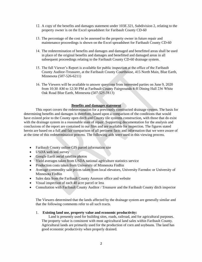
Benefits and damages statement This report covers the redetermination for a previously constructed drainage system. The basis for
determining benefits and damages is therefore, based upon a comparison of the conditions that would have existed prior to the County open ditch and County tile systems construction, with those that do exist
with the drainage system in a reasonable state of repair. Supporting documentation for the analysis and
conclusions of the report are contained in our files and are available for inspection. The figures stated
herein are based on a full and fair comparison of all pertinent facts and information that we were aware of at the time of this redetermination process. The following aids were used in this viewing process.
Faribault County online GIS parcel information site
USDA web soil survey
Google Earth aerial satellite photos
Yield averages taken from USDA national agriculture statistics service
Production costs taken from University of Minnesota FinBin
Average commodity sale prices taken from local elevators, University Farmdoc or University of
Minnesota FinBin
Sales data from the Faribault County Assessor office and website
Visual inspection of each 40 acre parcel or less
Consultation with Faribault County Auditor / Treasurer and the Faribault County ditch inspector
The Viewers determined that the lands affected by the drainage system are generally similar and
that the following comments refer to all such tracts.
1. Existing land use, property value and economic productivity: Land is presently used for building sites, roads, railroad, and for agricultural purposes.
The property value is consistent with most agricultural land sales within Faribault County. Agricultural lands are primarily used for the production of corn and soybeans. The land has
good economic productivity when properly drained.
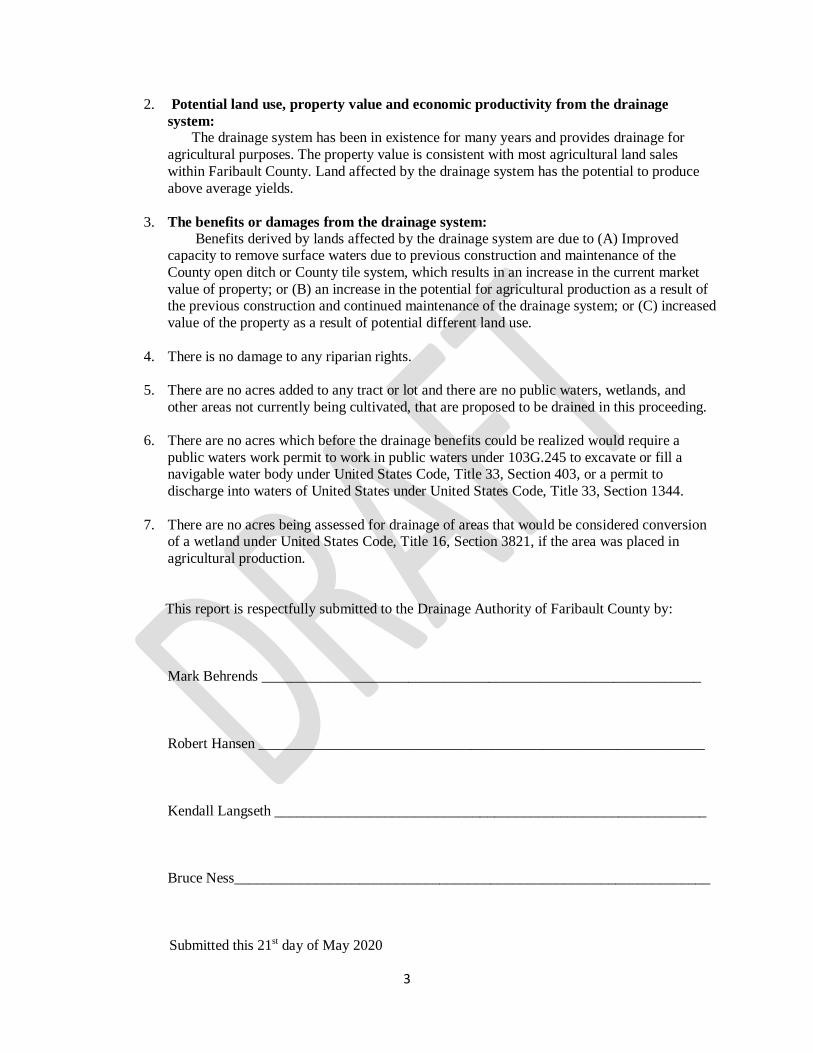
2. Potential land use, property value and economic productivity from the drainage
system: The drainage system has been in existence for many years and provides drainage for agricultural purposes. The property value is consistent with most agricultural land sales
within Faribault County. Land affected by the drainage system has the potential to produce
above average yields.
3. The benefits or damages from the drainage system: Benefits derived by lands affected by the drainage system are due to (A) Improved
capacity to remove surface waters due to previous construction and maintenance of the County open ditch or County tile system, which results in an increase in the current market
value of property; or (B) an increase in the potential for agricultural production as a result of
the previous construction and continued maintenance of the drainage system; or (C) increased
value of the property as a result of potential different land use.

1
State of Minnesota
County of Faribault
In the matter of the Redetermination
Of Benefits of Faribault County CD-60
Faribault County, Minnesota
May 21, 2020
(Draft)
Property Owners Report
Pursuant to Minnesota Statute 103E.323, the following is the Property Owners Report from
information in the Faribault County CD-60 Excel spreadsheet and Faribault County CD-60 Viewers Report, in the matter of the redetermination of benefits and damages, and damaged and benefitted acres of
Faribault County CD-60, Faribault County, Minnesota.
1. This redetermination of benefits sets the percentage that you will be required to pay for all future repairs and maintenance on Faribault County CD-60
2. The name and address of the property owner is shown on the Excel spreadsheet for Faribault County CD-60
3. The description of each lot or tract and its area that is benefitted or damaged is shown on the Excel spreadsheet for Faribault County CD-60
4. There are no acres added to any tract or lot and there are no public waters, wetlands, and
other areas not currently being cultivated that are proposed to be drained in this proceeding
5. There are no acres which before the drainage benefits could be realized would require a
public waters work permit to work in public waters under 103G.245 to excavate or fill a navigable water body under United States Code, Title 33, Section 403, or a permit to
discharge into waters of United States under United States Code, Title 33, Section 1344.
6. There are no acres being assessed for drainage of areas that would be considered conversion of a wetland under United States Code, Title 16, Section 3821, if the area was placed in
agricultural production
7. There are no damages to riparian rights
8. The amount of right-of-way acreage required is shown on the Excel spreadsheet for Faribault County CD-60
9. The amount that each tract or lot will be benefitted or damaged is shown on the Excel
spreadsheet for Faribault County CD-60
10. The damages or benefits to the property are shown on the Excel spreadsheet for Faribault
County CD-60
11. No construction is planned as part of this proceeding.
2
12. A copy of the benefits and damages statement under 103E.321, Subdivision 2, relating to the property owner is on the Excel spreadsheet for Faribault County CD-60
13. The percentage of the cost to be assessed to the property owner in future repair and maintenance proceedings is shown on the Excel spreadsheet for Faribault County CD-60
14. The redetermination of benefits and damages and damaged and benefitted areas shall be used in place of the original benefits and damages and benefitted and damaged areas in all subsequent proceedings relating to the Faribault County CD-60 drainage system.
15. The full Viewer’s Report is available for public inspection at the office of the Faribault County Auditor-Treasurer, at the Faribault County Courthouse, 415 North Main, Blue Earth, Minnesota (507-526-6211)
16. The Viewers will be available to answer questions from interested parties on June 9, 2020 from 10:30 AM to 12:30 PM at Faribault County Fairgrounds 4-H Dining Hall 236 White Oak Road Blue Earth, Minnesota (507-525-3813)
Benefits and damages statement This report covers the redetermination for a previously constructed drainage system. The basis for
determining benefits and damages is therefore, based upon a comparison of the conditions that would have existed prior to the County open ditch and County tile systems construction, with those that do exist
with the drainage system in a reasonable state of repair. Supporting documentation for the analysis and
conclusions of the report are contained in our files and are available for inspection. The figures stated
herein are based on a full and fair comparison of all pertinent facts and information that we were aware of at the time of this redetermination process. The following aids were used in this viewing process.
Faribault County online GIS parcel information site
USDA web soil survey
Google Earth aerial satellite photos
Yield averages taken from USDA national agriculture statistics service
Production costs taken from University of Minnesota FinBin
Average commodity sale prices taken from local elevators, University Farmdoc or University of
Minnesota FinBin
Sales data from the Faribault County Assessor office and website
Visual inspection of each 40 acre parcel or less
Consultation with Faribault County Auditor / Treasurer and the Faribault County ditch inspector
The Viewers determined that the lands affected by the drainage system are generally similar and
that the following comments refer to all such tracts.
1. Existing land use, property value and economic productivity: Land is presently used for building sites, roads, railroad, and for agricultural purposes.
The property value is consistent with most agricultural land sales within Faribault County.
Agricultural lands are primarily used for the production of corn and soybeans. The land has good economic productivity when properly drained.
3
2. Potential land use, property value and economic productivity from the drainage
system: The drainage system has been in existence for many years and provides drainage for
agricultural purposes. The property value is consistent with most agricultural land sales
within Faribault County. Land affected by the drainage system has the potential to produce
above average yields.
3. The benefits or damages from the drainage system: Benefits derived by lands affected by the drainage system are due to (A) Improved capacity to remove surface waters due to previous construction and maintenance of the
County open ditch or County tile system, which results in an increase in the current market
value of property; or (B) an increase in the potential for agricultural production as a result of the previous construction and continued maintenance of the drainage system; or (C) increased
value of the property as a result of potential different land use.
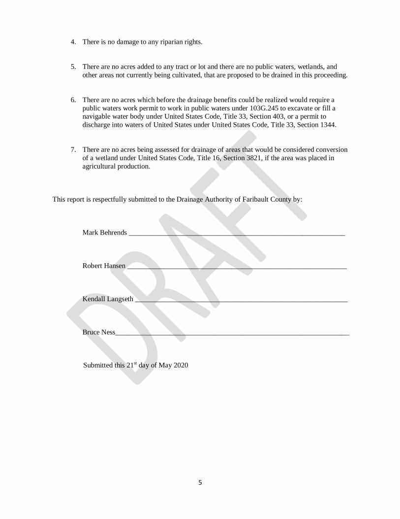
4. There is no damage to any riparian rights.
5. There are no acres added to any tract or lot and there are no public waters, wetlands, and
other areas not currently being cultivated, that are proposed to be drained in this proceeding.
6. There are no acres which before the drainage benefits could be realized would require a
public waters work permit to work in public waters under 103G.245 to excavate or fill a navigable water body under United States Code, Title 33, Section 403, or a permit to
discharge into waters of United States under United States Code, Title 33, Section 1344.
7. There are no acres being assessed for drainage of areas that would be considered conversion of a wetland under United States Code, Title 16, Section 3821, if the area was placed in
agricultural production.
This report is respectfully submitted to the Drainage Authority of Faribault County by:
Mark Behrends ____________________________________________________________
Robert Hansen _____________________________________________________________
Kendall Langseth ___________________________________________________________
Bruce Ness_________________________________________________________________
Submitted this 21st day of May 2020
5
4. There is no damage to any riparian rights.
5. There are no acres added to any tract or lot and there are no public waters, wetlands, and
other areas not currently being cultivated, that are proposed to be drained in this proceeding.
6. There are no acres which before the drainage benefits could be realized would require a
public waters work permit to work in public waters under 103G.245 to excavate or fill a navigable water body under United States Code, Title 33, Section 403, or a permit to
discharge into waters of United States under United States Code, Title 33, Section 1344.
7. There are no acres being assessed for drainage of areas that would be considered conversion
of a wetland under United States Code, Title 16, Section 3821, if the area was placed in
agricultural production.
This report is respectfully submitted to the Drainage Authority of Faribault County by:
Mark Behrends ____________________________________________________________
Robert Hansen _____________________________________________________________
Kendall Langseth ___________________________________________________________
Bruce Ness_________________________________________________________________
Submitted this 21st day of May 2020
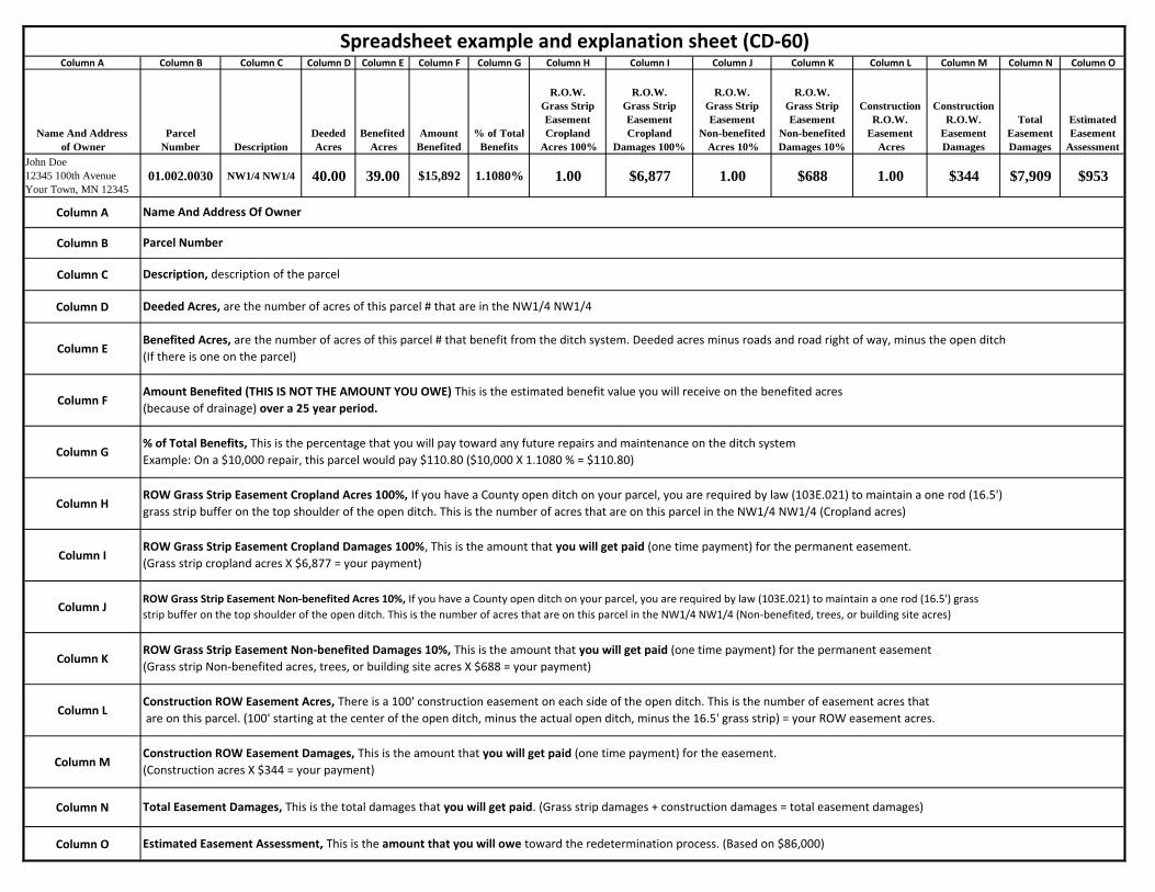
Column A Column B Column C Column D Column E Column F Column G Column H Column I Column J Column K Column L Column M Column N Column O
Name And Address
of Owner
Parcel
Number Description
Deeded
Acres
Benefited
Acres
Amount
Benefited
% of Total
Benefits
R.O.W.
Grass Strip
Easement
Cropland
Acres 100%
R.O.W.
Grass Strip
Easement
Cropland
Damages 100%
R.O.W.
Grass Strip
Easement
Non-benefited
Acres 10%
R.O.W.
Grass Strip
Easement
Non-benefited
Damages 10%
Construction
R.O.W.
Easement
Acres
Construction
R.O.W.
Easement
Damages
Total
Easement
Damages
Estimated
Easement
Assessment
John Doe
12345 100th Avenue
Your Town, MN 12345
01.002.0030 NW1/4 NW1/4 40.00 39.00 $15,892 1.1080% 1.00 $6,877 1.00 $688 1.00 $344 $7,909 $953
Column A
Column B
Column C
Column D
Column E
Column F
Column G
Column H
Column I
Column J
Column K
Column L
Column M
Column N
Column O
Spreadsheet example and explanation sheet (CD-60)
Name And Address Of Owner
Construction ROW Easement Damages, This is the amount that you will get paid (one time payment) for the easement.
(Construction acres X $344 = your payment)
Total Easement Damages, This is the total damages that you will get paid. (Grass strip damages + construction damages = total easement damages)
Estimated Easement Assessment, This is the amount that you will owe toward the redetermination process. (Based on $86,000)
Parcel Number
ROW Grass Strip Easement Cropland Acres 100%, If you have a County open ditch on your parcel, you are required by law (103E.021) to maintain a one rod (16.5')
grass strip buffer on the top shoulder of the open ditch. This is the number of acres that are on this parcel in the NW1/4 NW1/4 (Cropland acres)
ROW Grass Strip Easement Cropland Damages 100%, This is the amount that you will get paid (one time payment) for the permanent easement.
(Grass strip cropland acres X $6,877 = your payment)
ROW Grass Strip Easement Non-benefited Acres 10%, If you have a County open ditch on your parcel, you are required by law (103E.021) to maintain a one rod (16.5') grass
strip buffer on the top shoulder of the open ditch. This is the number of acres that are on this parcel in the NW1/4 NW1/4 (Non-benefited, trees, or building site acres)
ROW Grass Strip Easement Non-benefited Damages 10%, This is the amount that you will get paid (one time payment) for the permanent easement
(Grass strip Non-benefited acres, trees, or building site acres X $688 = your payment)
Construction ROW Easement Acres, There is a 100' construction easement on each side of the open ditch. This is the number of easement acres that
are on this parcel. (100' starting at the center of the open ditch, minus the actual open ditch, minus the 16.5' grass strip) = your ROW easement acres.
Description, description of the parcel
Deeded Acres, are the number of acres of this parcel # that are in the NW1/4 NW1/4
Benefited Acres, are the number of acres of this parcel # that benefit from the ditch system. Deeded acres minus roads and road right of way, minus the open ditch
(If there is one on the parcel)
Amount Benefited (THIS IS NOT THE AMOUNT YOU OWE) This is the estimated benefit value you will receive on the benefited acres
(because of drainage) over a 25 year period.
% of Total Benefits, This is the percentage that you will pay toward any future repairs and maintenance on the ditch system
Example: On a $10,000 repair, this parcel would pay $110.80 ($10,000 X 1.1080 % = $110.80)
Name And Address Of OwnerParcel
Number DescriptionDeededAcres
Benefited Acres
Amount Benefited
% Of totalBenefits
R.O.W. Grass StripEasementCropland
Acres
R.O.W. Grass StripEasementCroplandDamages
R.O.W. Grass StripEasement
10%Acres
R.O.W. Grass StripEasement
10%Damages
ConstructionR.O.W.
Easement Acres
ConstructionR.O.W.
EasementDamages
Total EasementDamages
EstimatedEasement
Assessment
JO DAVIES TOWNSHIP - Section 1 01-102-28NAVE, DOUGLAS D34899 W 30TH STELMORE, MN 56027 10.001.0700
NW1/4 SW1/415.78 AC IN 15.78 15.78 $11,023 0.7685% $661
NAVE, DOUGLAS D34899 W 30TH STELMORE, MN 56027 10.001.0700 W1/2 SW1/4 SW1/4 20.00 19.32 $14,489 1.0102% 0.15 $1,032 1.28 $440 $1,472 $869WILLNER, PAUL36463 120TH STBLUE EARTH, MN 56013 10.001.0900
NE1/4 SW1/4.26 AC IN 0.26 0.15 $56 0.0039% 0.09 $619 0.34 $117 $736 $3
WILLNER, PAUL36463 120TH STBLUE EARTH, MN 56013 10.001.0900
SE1/4 SW1/43.51 AC IN 3.51 3.51 $961 0.0670% $58
WILLNER, PAUL36463 120TH STBLUE EARTH, MN 56013 10.001.0900
NW1/4 SE1/415.0 AC INBORDER 15.00 6.59 $720 0.0502% 0.34 $2,338 1.31 $451 $2,789 $43
WILLNER, PAUL36463 120TH STBLUE EARTH, MN 56013 10.001.0900
SW1/4 SE1/47.0 AC INBORDER 7.00 7.00 $2,335 0.1628% $140
WILLNER, PAUL A & JACKIE J36463 120TH STBLUE EARTH, MN 56013 10.001.0901
SE1/4 SW1/45.23 AC INBORDER 5.23 4.28 $1,192 0.0831% $71
WILLNER, PAUL A & JACKIE J36463 120TH STBLUE EARTH, MN 56013 10.001.0901
SW1/4 SE1/4.48 AC INBORDER 0.48 0.08 $32 0.0022% $2
PFAFFINGER, DAVID & DENISE37133 120TH STBLUE EARTH, MN 56013 10.001.0902
NW1/4 SW1/415.17 AC IN 15.17 15.17 $10,404 0.7254% $624
PFAFFINGER, DAVID & DENISE37133 120TH STBLUE EARTH, MN 56013 10.001.0902
NE1/4 SW1/4EXCEPT 10.64 AC 29.36 29.25 $10,433 0.7274% 0.34 $2,338 1.31 $451 $2,789 $626
PFAFFINGER, DAVID & DENISE37133 120TH STBLUE EARTH, MN 56013 10.001.0902 E1/2 SW1/4 SW1/4 20.00 18.83 $14,231 0.9922% 0.55 $3,782 2.13 $733 $4,515 $853PFAFFINGER, DAVID & DENISE37133 120TH STBLUE EARTH, MN 56013 10.001.0902
SE1/4 SW1/4EXCEPT 8.74 AC 31.26 29.30 $10,914 0.7610% 1.08 $7,427 4.17 $1,434 $8,862 $654
PFAFFINGER, DAVID & DENISE37133 120TH STBLUE EARTH, MN 56013 10.001.0902
NW1/4 SE1/47.00 AC IN 7.00 6.59 $867 0.0604% 0.34 $2,338 1.31 $451 $2,789 $52
JO DAVIES TOWNSHIP - Section 2 02-102-28LAWRENCE FARMS INC1120 HIGHLAND DRBLUE EARTH, MN 56013 10.002.0100
NW1/4 SW1/4EXCEPT 7.97 AC
BORDER 32.03 5.03 $2,990 0.2085% $179LAWRENCE FARMS INC1120 HIGHLAND DRBLUE EARTH, MN 56013 10.002.0100 SW1/4 SW1/4 40.00 40.00 $26,748 1.8649% $1,604LAWRENCE FARMS INC1120 HIGHLAND DRBLUE EARTH, MN 56013 10.002.0100
SE1/4 SW1/4BORDER 40.00 37.00 $25,042 1.7459% $1,501
NAVE, DOUGLAS D34899 W 30TH STELMORE, MN 56027 10.002.0200
NE1/4 SE1/4EXCEPT 8.92 AC
BORDER 31.08 20.08 $12,800 0.8924% $767NAVE, DOUGLAS D34899 W 30TH STELMORE, MN 56027 10.002.0200
SW1/4 SE1/4BORDER 40.00 37.00 $26,873 1.8736% 1.92 $660 $660 $1,611
NAVE, DOUGLAS D34899 W 30TH STELMORE, MN 56027 10.002.0200 SE1/4 SE1/4 40.00 39.00 $28,000 1.9522% 1.92 $660 $660 $1,679
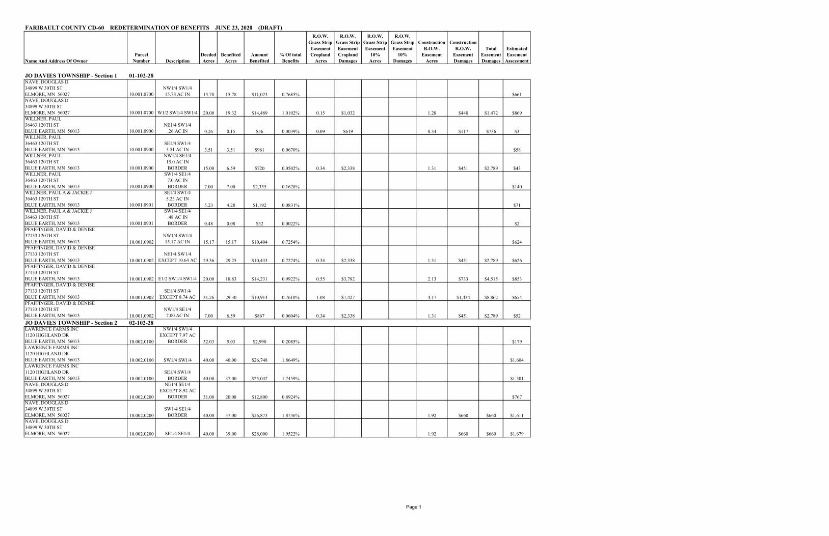
FARIBAULT COUNTY CD-60 REDETERMINATION OF BENEFITS JUNE 23, 2020 (DRAFT)
Page 1
Name And Address Of OwnerParcel
Number DescriptionDeededAcres
Benefited Acres
Amount Benefited
% Of totalBenefits
R.O.W. Grass StripEasementCropland
Acres
R.O.W. Grass StripEasementCroplandDamages
R.O.W. Grass StripEasement
10%Acres
R.O.W. Grass StripEasement
10%Damages
ConstructionR.O.W.
Easement Acres
ConstructionR.O.W.
EasementDamages
Total EasementDamages
EstimatedEasement
Assessment
FARIBAULT COUNTY CD-60 REDETERMINATION OF BENEFITS JUNE 23, 2020 (DRAFT)
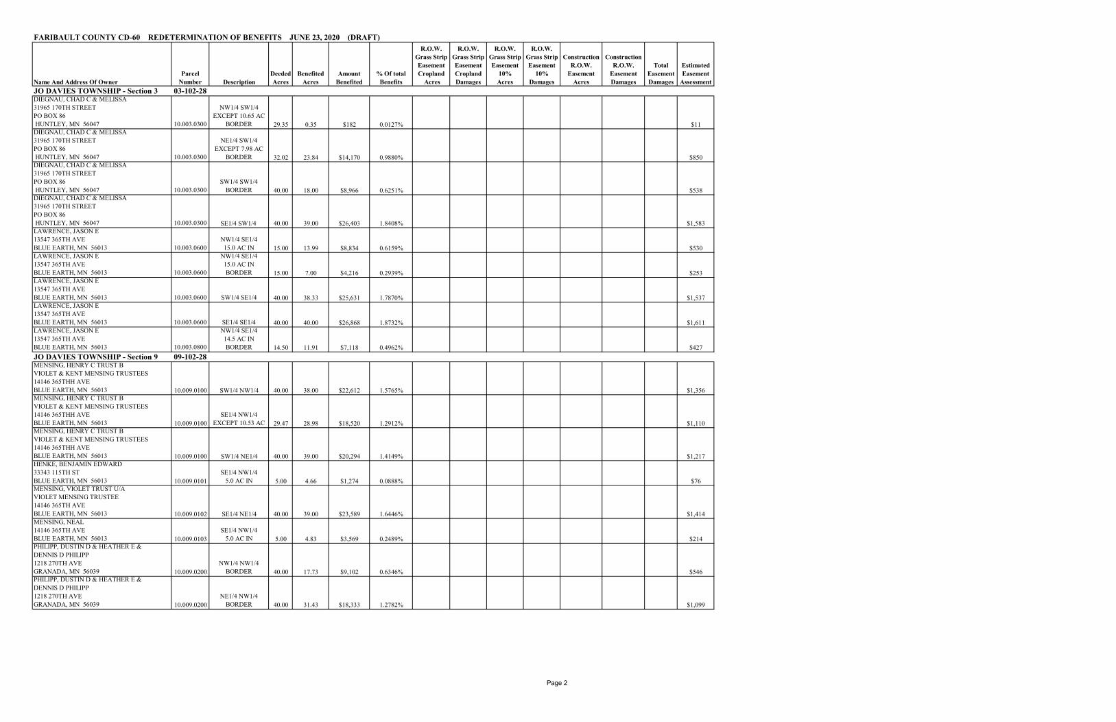
JO DAVIES TOWNSHIP - Section 3 03-102-28DIEGNAU, CHAD C & MELISSA31965 170TH STREETPO BOX 86 HUNTLEY, MN 56047 10.003.0300
NW1/4 SW1/4EXCEPT 10.65 AC
BORDER 29.35 0.35 $182 0.0127% $11DIEGNAU, CHAD C & MELISSA31965 170TH STREETPO BOX 86 HUNTLEY, MN 56047 10.003.0300
NE1/4 SW1/4 EXCEPT 7.98 AC
BORDER 32.02 23.84 $14,170 0.9880% $850DIEGNAU, CHAD C & MELISSA31965 170TH STREETPO BOX 86 HUNTLEY, MN 56047 10.003.0300
SW1/4 SW1/4BORDER 40.00 18.00 $8,966 0.6251% $538
DIEGNAU, CHAD C & MELISSA31965 170TH STREETPO BOX 86 HUNTLEY, MN 56047 10.003.0300 SE1/4 SW1/4 40.00 39.00 $26,403 1.8408% $1,583LAWRENCE, JASON E13547 365TH AVEBLUE EARTH, MN 56013 10.003.0600
NW1/4 SE1/415.0 AC IN 15.00 13.99 $8,834 0.6159% $530
LAWRENCE, JASON E13547 365TH AVEBLUE EARTH, MN 56013 10.003.0600
NW1/4 SE1/415.0 AC INBORDER 15.00 7.00 $4,216 0.2939% $253
LAWRENCE, JASON E13547 365TH AVEBLUE EARTH, MN 56013 10.003.0600 SW1/4 SE1/4 40.00 38.33 $25,631 1.7870% $1,537LAWRENCE, JASON E13547 365TH AVEBLUE EARTH, MN 56013 10.003.0600 SE1/4 SE1/4 40.00 40.00 $26,868 1.8732% $1,611LAWRENCE, JASON E13547 365TH AVEBLUE EARTH, MN 56013 10.003.0800
NW1/4 SE1/414.5 AC INBORDER 14.50 11.91 $7,118 0.4962% $427
JO DAVIES TOWNSHIP - Section 9 09-102-28MENSING, HENRY C TRUST BVIOLET & KENT MENSING TRUSTEES14146 365THH AVEBLUE EARTH, MN 56013 10.009.0100 SW1/4 NW1/4 40.00 38.00 $22,612 1.5765% $1,356MENSING, HENRY C TRUST BVIOLET & KENT MENSING TRUSTEES14146 365THH AVEBLUE EARTH, MN 56013 10.009.0100
SE1/4 NW1/4EXCEPT 10.53 AC 29.47 28.98 $18,520 1.2912% $1,110
MENSING, HENRY C TRUST BVIOLET & KENT MENSING TRUSTEES14146 365THH AVEBLUE EARTH, MN 56013 10.009.0100 SW1/4 NE1/4 40.00 39.00 $20,294 1.4149% $1,217HENKE, BENJAMIN EDWARD33343 115TH STBLUE EARTH, MN 56013 10.009.0101
SE1/4 NW1/45.0 AC IN 5.00 4.66 $1,274 0.0888% $76
MENSING, VIOLET TRUST U/AVIOLET MENSING TRUSTEE14146 365TH AVEBLUE EARTH, MN 56013 10.009.0102 SE1/4 NE1/4 40.00 39.00 $23,589 1.6446% $1,414MENSING, NEAL14146 365TH AVEBLUE EARTH, MN 56013 10.009.0103
SE1/4 NW1/45.0 AC IN 5.00 4.83 $3,569 0.2489% $214
PHILIPP, DUSTIN D & HEATHER E &DENNIS D PHILIPP1218 270TH AVEGRANADA, MN 56039 10.009.0200
NW1/4 NW1/4BORDER 40.00 17.73 $9,102 0.6346% $546
PHILIPP, DUSTIN D & HEATHER E &DENNIS D PHILIPP1218 270TH AVEGRANADA, MN 56039 10.009.0200
NE1/4 NW1/4BORDER 40.00 31.43 $18,333 1.2782% $1,099
Page 2

Name And Address Of OwnerParcel
Number DescriptionDeededAcres
Benefited Acres
Amount Benefited
% Of totalBenefits
R.O.W. Grass StripEasementCropland
Acres
R.O.W. Grass StripEasementCroplandDamages
R.O.W. Grass StripEasement
10%Acres
R.O.W. Grass StripEasement
10%Damages
ConstructionR.O.W.
Easement Acres
ConstructionR.O.W.
EasementDamages
Total EasementDamages
EstimatedEasement
Assessment
FARIBAULT COUNTY CD-60 REDETERMINATION OF BENEFITS JUNE 23, 2020 (DRAFT)
MURPHY, ROBERT TLIFE ESTATE ETAL11404 330TH AVEBLUE EARTH, MN 56013 10.009.0300
NW1/4 SW1/4 EXCEPT 16.5 AC 23.50 23.09 $16,784 1.1702% $1,006
MURPHY, ROBERT TLIFE ESTATE ETAL11404 330TH AVEBLUE EARTH, MN 56013 10.009.0300
NE1/4 SW1/4 EXCEPT 5.0 AC 35.00 34.00 $20,210 1.4090% $1,212
WINTER, MARY MARLENEBOX 234RAKE, IA 50465 10.009.0301
SW1/4 SW1/4EXCEPT 2.0 AC
BORDER 38.00 14.00 $5,280 0.3681% $317MURPHY, MITCHELL J & DIANNE L MURPHY33136 115TH STBLUE EARTH, MN 56013 10.009.0302
NW1/4 SW1/44.28 AC IN 4.28 4.01 $2,057 0.1434% $123
MURPHY, ROBERT TLIFE ESTATE ETAL11404 330TH AVEBLUE EARTH, MN 56013 10.009.0400
NW1/4 SW1/49.67 AC INBORDER 9.67 3.90 $1,598 0.1114% $96
LAWRENCE, WAYNE D & DONNA120 BARTEL DRBLUE EARTH, MN 56013 10.009.0500
SE1/4 SW1/4EXCEPT 3.9 AC
BORDER 36.10 28.09 $11,481 0.8005% $688LARSEN, JASON & LAURA9370 345TH AVEBLUE EARTH, MN 56013 10.009.0501
NE1/4 SW1/42.0 AC IN 2.00 1.82 $490 0.0341% $29
LARSEN, JASON & LAURA9370 345TH AVEBLUE EARTH, MN 56013 10.009.0501
SE1/4 SW1/43.4 AC IN 3.40 2.39 $987 0.0688% $59
PHILIPP, DUSTIN D & HEATHER E &DENNIS D PHILIPP1218 270TH AVEGRANADA, MN 56039 10.009.0600
NW1/4 NE1/4 BORDER 40.00 35.00 $21,187 1.4771% $1,270
PHILIPP, DUSTIN D & HEATHER E &DENNIS D PHILIPP1218 270TH AVEGRANADA, MN 56039 10.009.0600
NE1/4 NE1/4 BORDER 40.00 37.00 $26,910 1.8762% $1,614
LAWRENCE, DONNA R ETAL120TH BARTEL DRBLUE EARTH, MN 56013 10.009.0700
SW1/4 SE1/4EXCEPT 12.5 27.50 25.94 $14,660 1.0221% $879
LARSEN, JASON & LAURA9370 345TH AVEBLUE EARTH, MN 56013 10.009.0800
SW1/4 SE1/46.75 AC IN 6.75 6.10 $3,033 0.2115% $182
HANSON, MORRIS D & BARBARA J35611 140TH STWINNEBAGO, MN 56098 10.009.0801
SW1/4 SE1/4 8.0 AC IN 8.00 7.09 $4,429 0.3088% $266
GEORGE LANE BUCK TRUST15 OAK PARK COURTBETTENDORF, IA 52722 10.009.1000
NW1/4 SE1/4EXCEPT 5.0 AC 35.00 34.00 $23,166 1.6152% $1,389
GEORGE LANE BUCK TRUST15 OAK PARK COURTBETTENDORF, IA 52722 10.009.1000
NE1/4 SE1/4EXCEPT 5.0 AC 35.00 34.00 $21,851 1.5234% $1,310
BENZ, LOREN R & KATHLEEN A302 OAK KNOLL CTBLUE EARTH, MN 56013 10.009.1100
SE1/4 SE1/418.0 AC IN 18.00 16.45 $9,937 0.6928% $596
HANSON, MORRIS D & BARBARA J35611 140TH STWINNEBAGO, MN 56098 10.009.1101
SE1/4 SE1/4EXCEPT 18.0 AC 22.00 20.45 $16,349 1.1398% $980
JO DAVIES TOWNSHIP - Section 10 10-102-28PFAFFINGER, OTTO C FAM TRUST &VIVIAN PFAFFINGER REVOC TRUST2235 ROCKWOOD AVE APT 308SAINT PAUL, MN 55116 10.010.0200 NW1/4 NE1/4 40.00 37.73 $28,263 1.9705% 1.05 $7,221 4.02 $1,383 $8,604 $1,695
Page 3

Name And Address Of OwnerParcel
Number DescriptionDeededAcres
Benefited Acres
Amount Benefited
% Of totalBenefits
R.O.W. Grass StripEasementCropland
Acres
R.O.W. Grass StripEasementCroplandDamages
R.O.W. Grass StripEasement
10%Acres
R.O.W. Grass StripEasement
10%Damages
ConstructionR.O.W.
Easement Acres
ConstructionR.O.W.
EasementDamages
Total EasementDamages
EstimatedEasement
Assessment
FARIBAULT COUNTY CD-60 REDETERMINATION OF BENEFITS JUNE 23, 2020 (DRAFT)
PFAFFINGER, OTTO C FAM TRUST &VIVIAN PFAFFINGER REVOC TRUST2235 ROCKWOOD AVE APT 308SAINT PAUL, MN 55116 10.010.0200 NE1/4 NE1/4 40.00 38.62 $29,495 2.0564% 1.14 $7,840 4.37 $1,503 $9,343 $1,768PFAFFINGER, OTTO C FAM TRUST &VIVIAN PFAFFINGER REVOC TRUST2235 ROCKWOOD AVE APT 308SAINT PAUL, MN 55116 10.010.0200
SW1/4 NE1/4EXCEPT 5.49 AC 34.51 33.84 $20,500 1.4293% $1,229
PFAFFINGER, OTTO C FAM TRUST &VIVIAN PFAFFINGER REVOC TRUST2235 ROCKWOOD AVE APT 308SAINT PAUL, MN 55116 10.010.0200
SE1/4 NE1/4EXCEPT 1.58 AC 38.42 37.51 $24,209 1.6878% $1,452
JAHNKE, DEAN R & SUSAN K34747 115TH STBLUE EARTH, MN 56013 10.010.0201
SW1/4 NE1/45.49 AC IN 5.49 5.15 $905 0.0631% $54
JAHNKE, DEAN R & SUSAN K34747 115TH STBLUE EARTH, MN 56013 10.010.0201
SE1/4 NE1/41.58 AC IN 1.58 1.49 $724 0.0504% $43
MURPHY, PATRICIA A FAMILY TRUSTC/O REBECCA L BRANICK4712 SUNDANCE CIRCLESIOUX FALLS, SD 57105 10.010.0300 SE1/4 NW1/4 40.00 38.00 $27,911 1.9459% $1,673MURPHY, PATRICIA A FAMILY TRUSTC/O REBECCA L BRANICK4712 SUNDANCE CIRCLESIOUX FALLS, SD 57105 10.010.0300
NW1/4 SE1/4EXCEPT 5.3 AC
BORDER 34.70 17.84 $11,487 0.8009% $689MURPHY, PATRICIA A FAMILY TRUSTC/O REBECCA L BRANICK4712 SUNDANCE CIRCLESIOUX FALLS, SD 57105 10.010.0300
NE1/4 SE1/4EXCEPT 5.31 AC
BORDER 34.69 20.69 $14,085 0.9820% $845VIOLET MENSING TRUST U/AVIOLET MENSING TRUSTEE14146 365TH AVEBLUE EARTH, MN 56013 10.010.0400 SW1/4 NW1/4 40.00 39.00 $21,191 1.4774% $1,271BRANICK, REBECCA L ETAL4712 SUNDANCE CIRCLESIOUX FALLS, SD 57105 10.010.0500
NW1/4 SW1/4EXCEPT 4.0 AC 36.00 35.00 $24,326 1.6960% $1,459
MENSING, NEAL & BRENDA14136 365TH AVEBLUE EARTH, MN 56013 10.010.0601
NE1/4 SW1/4EXCEPT 5.0 AC 35.00 33.14 $23,527 1.6403% $1,411
PHILIPP, DUSTIN D & HEATHER E &DENNIS D PHILIPP1218 270TH AVEGRANADA, MN 56039 10.010.0700 NW1/4 NW1/4 40.00 39.00 $27,220 1.8978% $1,632HAGEDON, HARVEY35624 140TH STWINNEBAGO, MN 56098 10.010.0800 NE1/4 NW1/4 40.00 36.85 $27,707 1.9317% 0.95 $6,533 3.64 $1,252 $7,785 $1,661MENSING, KENT14635 US HWY 169BLUE EARTH, MN 56013 10.010.0900
SW1/4 SW1/48.15 AC IN 8.15 6.61 $3,929 0.2739% $236
STATELINE COOPERATIVEPO BOX 67BURT, IA 50522 10.010.0901
SW1/4 SW1/14EXCEPT 10.15 AC 29.85 28.31 $19,305 1.3459% $1,157
JO DAVIES TOWNSHIP - Section 11 11-102-28PFAFFINGER, OTTO C FAM TRUST &VIVIAN PFAFFINGER REVOC TRUST2235 ROCKWOOD AVE APT 308SAINT PAUL, MN 55116 10.011.0100 NW1/4 NW1/4 40.00 38.70 $28,754 2.0047% 1.08 $7,427 4.14 $1,424 $8,851 $1,724PFAFFINGER, OTTO C FAM TRUST &VIVIAN PFAFFINGER REVOC TRUST2235 ROCKWOOD AVE APT 308SAINT PAUL, MN 55116 10.011.0100 NE1/4 NW1/4 40.00 38.48 $27,939 1.9479% 1.25 $8,596 4.81 $1,655 $10,251 $1,675
Page 4
Name And Address Of OwnerParcel
Number DescriptionDeededAcres
Benefited Acres
Amount Benefited
% Of totalBenefits
R.O.W. Grass StripEasementCropland
Acres
R.O.W. Grass StripEasementCroplandDamages
R.O.W. Grass StripEasement
10%Acres
R.O.W. Grass StripEasement
10%Damages
ConstructionR.O.W.
Easement Acres
ConstructionR.O.W.
EasementDamages
Total EasementDamages
EstimatedEasement
Assessment
FARIBAULT COUNTY CD-60 REDETERMINATION OF BENEFITS JUNE 23, 2020 (DRAFT)
PFAFFINGER, OTTO C FAM TRUST &VIVIAN PFAFFINGER REVOC TRUST2235 ROCKWOOD AVE APT 308SAINT PAUL, MN 55116 10.011.0100 SW1/4 NW1/4 40.00 39.00 $25,988 1.8119% $1,558PFAFFINGER, OTTO C FAM TRUST &VIVIAN PFAFFINGER REVOC TRUST2235 ROCKWOOD AVE APT 308SAINT PAUL, MN 55116 10.011.0100 SE1/4 NW1/4 40.00 39.00 $26,031 1.8148% $1,561PFAFFINGER, OTTO C FAM TRUST &VIVIAN PFAFFINGER REVOC TRUST2235 ROCKWOOD AVE APT 308SAINT PAUL, MN 55116 10.011.0100 NW1/4 NE1/4 40.00 37.79 $25,703 1.7920% 0.50 $3,439 0.50 $344 1.92 $660 $4,443 $1,541PFAFFINGER, OTTO C FAM TRUST &VIVIAN PFAFFINGER REVOC TRUST2235 ROCKWOOD AVE APT 308SAINT PAUL, MN 55116 10.011.0100 SW1/4 NE1/4 40.00 38.00 $24,701 1.7222% $1,481HAGEDORN, HARVEY & LEOLA35624 140TH STWINNEBAGO, MN 56098 10.011.0200
NW1/4 SW1/4EXCEPT 6.19 AC
BORDER 33.30 17.46 $11,127 0.7758% $667KROSCH, LOUISA35188 115TH STBLUE EARTH, MN 56013 10.011.0300
NW1/4 SW1/43.16 AC INBORDER 3.16 1.68 $683 0.0476% $41
PFAFFINGER, DAVID & DENISE37133 120TH STBLUE EARTH, MN 56013 10.011.0400 NE1/4 NE1/4 40.00 36.79 $29,194 2.0354% 0.50 $3,439 0.50 $344 1.92 $660 $4,443 $1,750PFAFFINGER, DAVID & DENISE37133 120TH STBLUE EARTH, MN 56013 10.011.0400 SE1/4 NE1/4 40.00 38.00 $28,080 1.9577% $1,684PFAFFINGER, JOHN T & GEORGIANN M PFAFFINGER60 SOUTHWOOD DRPO BOX 765FAIRMONT, MN 56031 10.011.0600
NW1/4 SE1/4EXCEPT 7.97 AC
BORDER 32.03 15.55 $9,055 0.6313% $543PFAFFINGER, JOHN T & GEORGIANN M PFAFFINGER60 SOUTHWOOD DRPO BOX 765FAIRMONT, MN 56031 10.011.0600
NE1/4 SE1/418.5 AC INBORDER 18.50 7.03 $4,210 0.2935% $252
CERVANTES, MARK & DARLENE35612 115TH STBLUE EARTH, MN 56013 10.011.0601
NW1/4 SE1/44.92 AC INBORDER 4.92 2.51 $804 0.0561% $48
JO DAVIES TOWNSHIP - Section 12 12-102-28PFAFFINGER, DAVID ETAL37133 120TH STBLUE EARTH, MN 56013 10.012.0700 NW1/4 NW1/4 40.00 38.49 $28,397 1.9798% 0.21 $1,444 0.21 $144 0.80 $275 $1,864 $1,703PFAFFINGER, DAVID ETAL37133 120TH STBLUE EARTH, MN 56013 10.012.0700 NE1/4 NW1/4 40.00 39.00 $28,915 2.0159% $1,734PFAFFINGER, DAVID ETAL37133 120TH STBLUE EARTH, MN 56013 10.012.0700 SW1/4 NW1/4 40.00 39.00 $28,414 1.9810% $1,704PFAFFINGER, DAVID ETAL37133 120TH STBLUE EARTH, MN 56013 10.012.0700 SE1/4 NW1/4 40.00 39.00 $24,819 1.7304% $1,488JO DAVIES TOWNSHIP - Section 15 15-102-28MENSING, NEAL D & BRENDA R14136 365TH AVEBLUE EARTH, MN 56013 10.015.0200
NE1/4 NW1/4BORDER 40.00 3.00 $1,034 0.0721% $62
MENSING, KENT14635 US HWY 169BLUE EARTH, MN 56013 10.015.0400
NW1/4 NW1/4BORDER 40.00 39.00 $19,115 1.3327% $1,146
MENSING, KENT14635 US HWY 169BLUE EARTH, MN 56013 10.015.0400
SW1/4 NW1/4EXCEPT 1.64 AC
BORDER 38.36 4.00 $1,777 0.1239% $107
Page 5
Name And Address Of OwnerParcel
Number DescriptionDeededAcres
Benefited Acres
Amount Benefited
% Of totalBenefits
R.O.W. Grass StripEasementCropland
Acres
R.O.W. Grass StripEasementCroplandDamages
R.O.W. Grass StripEasement
10%Acres
R.O.W. Grass StripEasement
10%Damages
ConstructionR.O.W.
Easement Acres
ConstructionR.O.W.
EasementDamages
Total EasementDamages
EstimatedEasement
Assessment
FARIBAULT COUNTY CD-60 REDETERMINATION OF BENEFITS JUNE 23, 2020 (DRAFT)
JO DAVIES TOWNSHIP - Section 16 16-102-28BENZ, LOREN R & KATHLEEN A302 OAK KNOLL CTBLUE EARTH, MN 56013 10.016.0200
SE1/4 NE1/4EXCEPT 9.0 AC
BORDER 31.00 10.70 $4,435 0.3092% $266RICARD, STEVE & MEAGAN33999 105TH STBLUE EARTH, MN 56013 10.016.0201
SE1/4 NE1/49.0 AC INBORDER 9.00 1.60 $0 0.0000% $0
BENZ, LOREN R & KATHLEEN A302 OAK KNOLL CTBLUE EARTH, MN 56013 10.016.0300 NE1/4 NE1/4 40.00 40.00 $18,502 1.2900% $1,109LAWRENCE, WAYNE D & DONNA120 BARTEL DRBLUE EARTH, MN 56013 10.016.0600
NE1/4 NW1/4BORDER 40.00 32.70 $10,904 0.7602% $654
LAWRENCE, DONNA R ETAL120 BARTEL DRBLUE EARTH, MN 56013 10.016.0700
SE1/4 NW1/4EXCEPT 5.46 AC
BORDER 34.54 4.00 $730 0.0509% $44LAWRENCE, DONNA R ETAL120 BARTEL DRBLUE EARTH, MN 56013 10.016.0700
NW1/4 NE1/4BORDER 40.00 38.00 $15,892 1.1080% $953
LAWRENCE, DONNA R ETAL120 BARTEL DRBLUE EARTH, MN 56013 10.016.0700
SW1/4 NE1/4EXCEPT 5.46 AC
BORDER 40.00 4.50 $1,586 0.1106% $95LAND TOTALS 2,189.10 $1,371,769 95.6396% 9.57 $65,813 1.21 $832 41.31 $14,211 $80,856 $82,250
ROADSFARIBAULT COUNTYC/O DARREN ESSER415 N MAINBLUE EARTH, MN 56013-0130
CO HWY 16110TH STPAVED 13.80 $12,793 0.8919% $767
FARIBAULT COUNTYC/O DARREN ESSER415 N MAINBLUE EARTH, MN 56013-0130
CO HWY 5345TH AVE
PAVED 14.00 $12,978 0.9048% $778JO DAVIESS TOWNSHIPJUSTIN HOUGEN - CLERK36267 100TH STBLUE EARTH, MN 56013
115TH STGRAVEL 23.60 $14,585 1.0169% $874
JO DAVIESS TOWNSHIPJUSTIN HOUGEN - CLERK36267 100TH STBLUE EARTH, MN 56013
120TH STGRAVEL 12.50 $7,725 0.5386% $463
JO DAVIESS TOWNSHIPJUSTIN HOUGEN - CLERK36267 100TH STBLUE EARTH, MN 56013
330TH AVEGRAVEL 1.50 $927 0.0646% $56
JO DAVIESS TOWNSHIPJUSTIN HOUGEN - CLERK36267 100TH STBLUE EARTH, MN 56013
355TH AVEGRAVEL 2.00 $1,236 0.0862% $74
JO DAVIESS TOWNSHIPJUSTIN HOUGEN - CLERK36267 100TH STBLUE EARTH, MN 56013
357TH AVEGRAVEL 4.00 $2,472 0.1723% $148
ROAD TOTAL 71.40 $52,715 3.6753% $3,161
RAILROADUNITED PACIFIC RAILROAD1400 DOUGLAS STREETOMAHA, NE 68179 15.90 $9,826 0.6851% $589RAILROAD TOTAL 15.90 $9,826 0.6851% $589
LAND, ROAD, RAILROAD TOTAL 2,276.40 $1,434,311 100.0000% $86,000
Page 6

T 1 0 3 R 2 8T 1 0 3 R 2 8V e r o n aV e r o n a
T 1 0 2 R 2 8T 1 0 2 R 2 8J o D a v i e s sJ o D a v i e s s
2 02 0 2 12 1 2 22 2 2 32 3 2 42 4
2 52 52 62 62 72 72 82 82 92 9
3 23 2 3 33 3 3 43 4 3 53 5 3 63 6
0 10 10 20 20 30 30 40 40 50 5
0 80 8 0 90 9 1 01 0 1111 1 21 2
1 31 31 41 41 51 51 61 61 71 7
2 02 0 2 12 1 2 22 2 2 32 3 2 42 4
2 52 52 62 62 72 72 82 82 92 9
3 03 0
120TH ST
115TH ST
105TH ST
330T
H AV
E
360T
H AV
E
330T
H AV
E
345T
H AV
E
340T
HAV
E
85TH ST
357T
H AV
E
140TH ST
95TH ST
150TH ST
347T
H AV
E
355T
H AV
E
335T
H AV
E
100TH ST
330T
H AV
E
355T
H AV
E35
5TH
AVE
365T
H AV
E
370T
H AV
E
365T
H AV
E
355T
H AV
E
150TH ST
105TH ST
340T
H AV
E
353R
D AV
E
370T
H AV
E
96TH ST
120TH ST
370T
H AV
E
357T
H AV
E
90TH ST
130TH ST
96TH ST
345T
H AV
E
WELK
DR
90TH ST
110TH ST
85TH ST
360T
H AV
E
330T
H AV
E
§̈¦90 §̈¦90
")8
")16
")6
")9
")5
")6
CD21
JD4FM
JCD202FM (JD12MF)
JD19F CD52
CD514JD20F
JD22F
JD21F
CD50
CD60
CD33
FARIBAULT COUNTYDITCH NO. 60(CD60)
&www.co.faribault.mn.us
1 inch = 3,500 feet
Disclaimer: Faribault County does not warrant or guarantee accuracy of the GIS data. The data is meantfor reference purposes only and should not be used for official decisions. The data contained in the maps were compiled from the best available records that could be found and may contain errors or omissions.
LegendDitch Viewer BasinPublic Open Ditch
! ! ! ! Public Shallow DitchPublic TilePublic WatercourseRiver or StreamParcelsInterstate/US/MNCSAHCountyTownshipMunicipalOther