field report inspection form 11-10-21
TRANSCRIPT

1
Dredging Inspection Field Report
Site Observations Date: ________________11/10/2021____________________________ Field Engineer: _______Mike Triano ________________________________
Weather Conditions: _________Breezy, Overcast _ __ Temperature: _______ 70s___
Wood Project Number: ___________2402210005.01.01___________ Client: ______Isle of Palms______________________ _________________
Contractor: _________Branch Diversified (BDI)_____________________ Foreman Onsite: ______Brett Tucker & Lance Young __
Item Observations Photo
Crew Size & Location
**Only One Barge with Excavator Dredging at Time of Inspection** 30’ x 80’ barge, moored off to the large ~ 50’ X 100’+ Hopper barge in the intracoastal. The 30’ X 80’ Barge is used to unload the smaller barges. The ~ 50’ X 100’+ Hopper barge is used to transport material to DMMA. Both Barges are located east of Baseline 1 in the Intracoastal: Southern IOP. One 20’ Wide push barge actively dredging Baseline 3 – South IOP One Tug pushing 20’ Wide barge back and forth from Baseline 3 – South IOP. One large tug moving large Hopper barges to the DMMA 20’ aluminum boat used to travel to and from the site
Photo: 1 & 3 See Map
Equipment on Site
Same as Crew size, 1 mechanical dredge (excavators) plus 2 barges
Photos: 1 & 3
Work Completed
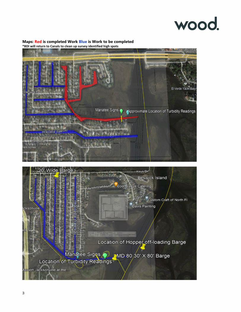
Majority of Northern IOP Canals. * Portions of Baseline 1, 2, 3, 4 and 5 Southern IOP Canals BDI advised dredging occurs in two phases: on the way in for access & removal of top layer of sediment and on the way out for getting canal to specified grade. This is true for all canals that barges cannot initially access.
See Map
Work Underway
Actively Dredging Baseline 3 South IOP. See Map
Materials on Site
Stored in ~100’+ X 50’ Hopper barge moored in the intracoastal. East of Baseline 1: South IOP.
Photo: 1 & 3
Manatee Observer
All crew on barges were advised to keep eye out for Manatees - signs posted on northern and southern canals.
Photos: 4
Turbidity Monitoring
Background Reading: *** NTU Monitoring Reading: *** NTU Monitoring Reading: *** NTU
Photos: 5 (To be provided)
Dewatering
Lance advised dewatering does not occur - drain holes are located in bottom of containers. Lance advised inner canals are mixing zones and therefore sediment/water returning to canals are not of concern.
Dredging Mechanical

2
Offloading Location
Large ~50’ -100’+ Hopper barge– east of Baseline 1: Southern IOP. BDI advised that trips to Reed Island DMMA are taken once these large barges are full, that usually occurs once a day.
Photo: 1
Posted Permit Permits are not posted. BDI was provided with additional copies.
Other…
See Additional Comments Below
*BDI will return to Canals to clean up survey identified high spots*
Additional Notes Projected Schedule:
BDI indicated that Baseline 3 in the South IOP is the final canal to be completed. Conversation with operator and Lance Young indicated this Baseline will be finished in two weeks.
Lance Young indicated that he will schedule a survey over the entire project once Baseline 3 – South IOP is completed to determine areas that need to be re-visited.
Anticipated Obstacles to Meeting Schedule:
Equipment malfunctioning / no operator to dig / Barges at Idle.
Displaced material causing contractor to re-work areas to correct high spots.
Engineer’s Notes:
Lance indicated they put a team together to reach the tight spots at the end of Baseline 2 and 6 in the northern IOP canals and dredged them to grade.
Inspection was able to be completed in person with Lance Young and Brett Tucker in attendance.
Depths were gauged within Baseline 3 using fathometer attached to 20’ skiff to track progress within canal at the time of the inspection.
BDI indicated that they contracted surveying firm other than Arc to perform survey for Southern IOP baselines. Lance indicated that this was done to compare a third set of data with their own data from barge counts, and Arc’s surveying data.
Field Engineer Signature:
Date: _____11/10/2021_____________________________________
3
Maps: Red is completed Work Blue is Work to be completed *BDI will return to Canals to clean up survey identified high spots

4
Photograph Log:
Photo 1: Large Hopper Barge & 20’ Push Barge and Tug headed to off load.
Photo 2: Typical view down Baseline 3 – South IOP.
This was taken during the fathometer reading.

5
Photo 3: 20’ Push-Barge and Tug within Baseline 3 South IOP.
Photo 4: Entrance to South IOP canals – Manatee Sign and Turbidity Curtain visible in background.
Photo 5: 11/10/2021 Turbidity Monitoring form.