final report to 18 february 2015 tenements mcn’s...
TRANSCRIPT
Page 1
Final Report to
18 February 2015
Tenements
MCN’s 4701-4703
Map sheets Pine Creek SD5208 - 1:250,000 scale
McKinlay River 5271 - 1:100,000 scale
Distribution:-
1. DOR Darwin, NT 2. Crocodile Gold Australia, Darwin 3. Rockland Resources, Brisbane 4. Phoenix Copper, Adelaide
Amanda Schwartz April 2015
Page 2
TABLE OF CONTENTS
1 EXECUTIVE SUMMARY ............................................................................... 3
2 COPYRIGHT .................................................................................................. 4
3 INTRODUCTION ............................................................................................ 5
4 LOCATION AND ACCESS ............................................................................ 5
5 TENEMENT DETAILS ................................................................................... 8
6 GEOLOGICAL SETTING ............................................................................... 8
6.1 Regional Geology .......................................................................................... 8
6.2 Local Geology .............................................................................................. 13
7 EXPLORATION ACTIVITIES Pre-2011 ....................................................... 15
7.1 EXPLORATION ACTIVITIES 2009- 31 DECEMBER 2014 ............................ 16
8 REFERENCES ............................................................................................. 17
LIST OF FIGURES
FIGURE 1: RELINQUISHED TENEMENT LOCATION MAP ................................................................................................ 3 FIGURE 2: RELINQUISHED MCN'S LOCATION MAP .................................................................................................... 7 FIGURE 3: STRATIGRAPHIC COLUMN, PINE CREEK OROGEN (GILLMAN ET AL, 2009) ...................................................... 10 FIGURE 4: RELINQUISHED TENEMENT LOCATION ON A REGIONAL GEOLOGY BASE .......................................................... 12 FIGURE 5: LOCAL GEOLOGY AND LOCATION OF RELINQUISHED TENEMENTS .................................................................. 13
LIST OF TABLES
TABLE 1: CURRENT RESOURCES .............................................................................................................................. 5 TABLE 2: TENEMENT DETAILS ................................................................................................................................ 8
Page 3
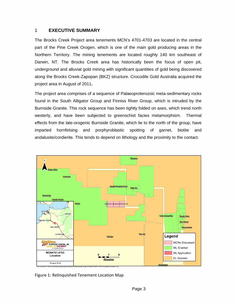
1 EXECUTIVE SUMMARY
The Brocks Creek Project area tenements MCN’s 4701-4703 are located in the central
part of the Pine Creek Orogen, which is one of the main gold producing areas in the
Northern Territory. The mining tenements are located roughly 140 km southeast of
Darwin, NT. The Brocks Creek area has historically been the focus of open pit,
underground and alluvial gold mining with significant quantities of gold being discovered
along the Brocks Creek-Zapopan (BKZ) structure. Crocodile Gold Australia acquired the
project area in August of 2011.
The project area comprises of a sequence of Palaeoproterozoic meta-sedimentary rocks
found in the South Alligator Group and Finniss River Group, which is intruded by the
Burnside Granite. This rock sequence has been tightly folded on axes, which trend north
westerly, and have been subjected to greenschist facies metamorphism. Thermal
effects from the late-orogenic Burnside Granite, which lie to the north of the group, have
imparted hornfelsing and porphyroblastic spotting of garnet, biotite and
andalusite/cordierite. This tends to depend on lithology and the proximity to the contact.
Figure 1: Relinquished Tenement Location Map

Page 4
Exploration activities conducted over the relinquished tenements from 2011 to 2014
included several desktop reviews and campaigns of reconnaissance mapping and data
compilation.
Crocodile Gold has made the decision to relinquish mineral titles MCN4701, M|CN4702
and MCN4703 (Figure 1) to allow another party to conduct exploration activities within
the area.
2 COPYRIGHT
This document and its content are the copyright of Crocodile Gold Australian Operations
(CGAO). The document has been written by Amanda Schwartz for submission to the
Northern Territory Department of Mines and Energy as part of the tenement reporting
requirements as per Regulation 86 of the Mineral Titles Act.
Any information included in the report that originates from historical reports or other
sources is listed in the “References” section at the end of the document.
This report may be released to open file as per Regulation 125(3) (b).
Page 5
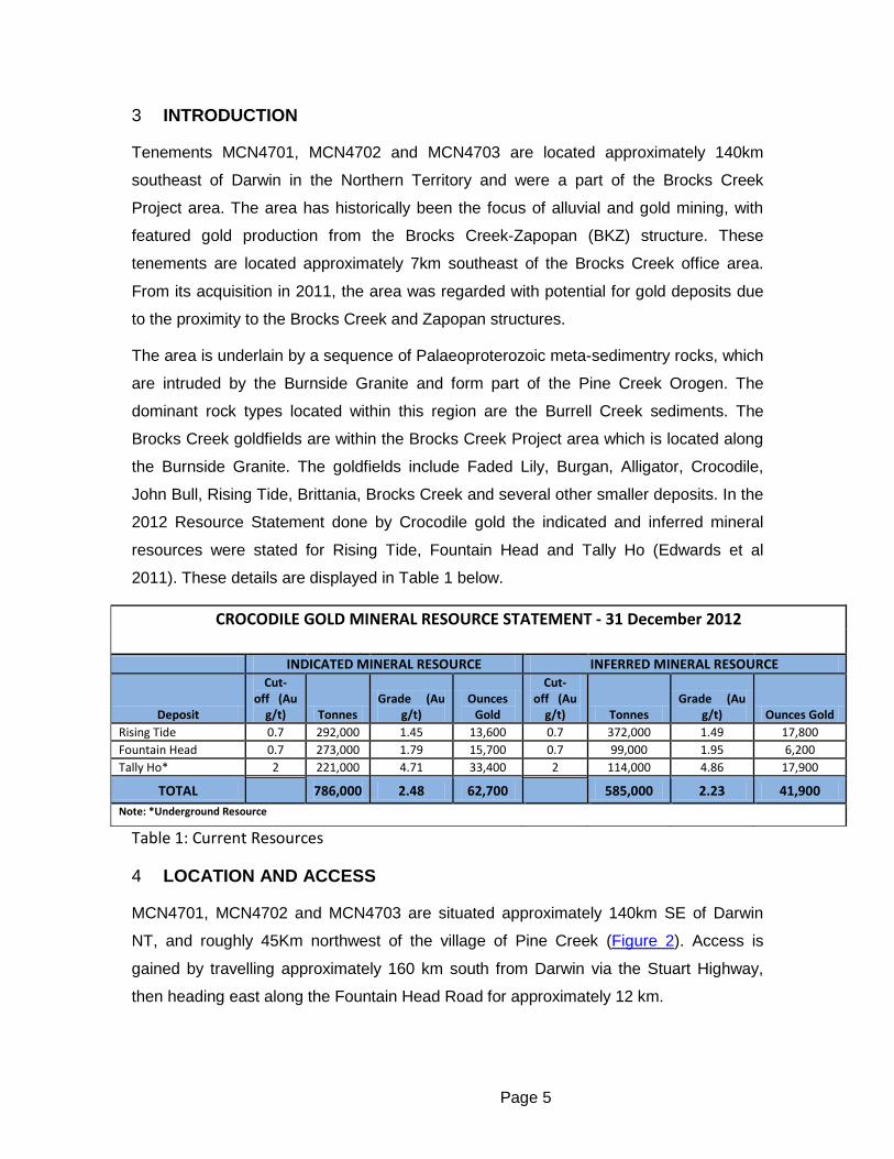
3 INTRODUCTION
Tenements MCN4701, MCN4702 and MCN4703 are located approximately 140km
southeast of Darwin in the Northern Territory and were a part of the Brocks Creek
Project area. The area has historically been the focus of alluvial and gold mining, with
featured gold production from the Brocks Creek-Zapopan (BKZ) structure. These
tenements are located approximately 7km southeast of the Brocks Creek office area.
From its acquisition in 2011, the area was regarded with potential for gold deposits due
to the proximity to the Brocks Creek and Zapopan structures.
The area is underlain by a sequence of Palaeoproterozoic meta-sedimentry rocks, which
are intruded by the Burnside Granite and form part of the Pine Creek Orogen. The
dominant rock types located within this region are the Burrell Creek sediments. The
Brocks Creek goldfields are within the Brocks Creek Project area which is located along
the Burnside Granite. The goldfields include Faded Lily, Burgan, Alligator, Crocodile,
John Bull, Rising Tide, Brittania, Brocks Creek and several other smaller deposits. In the
2012 Resource Statement done by Crocodile gold the indicated and inferred mineral
resources were stated for Rising Tide, Fountain Head and Tally Ho (Edwards et al
2011). These details are displayed in Table 1 below.
CROCODILE GOLD MINERAL RESOURCE STATEMENT - 31 December 2012
INDICATED MINERAL RESOURCE INFERRED MINERAL RESOURCE
Deposit
Cut-off (Au
g/t) Tonnes Grade (Au
g/t) Ounces
Gold
Cut-off (Au
g/t) Tonnes Grade (Au
g/t) Ounces Gold Rising Tide 0.7 292,000 1.45 13,600 0.7 372,000 1.49 17,800 Fountain Head 0.7 273,000 1.79 15,700 0.7 99,000 1.95 6,200 Tally Ho* 2 221,000 4.71 33,400 2 114,000 4.86 17,900
TOTAL 786,000 2.48 62,700 585,000 2.23 41,900 Note: *Underground Resource
Table 1: Current Resources
4 LOCATION AND ACCESS
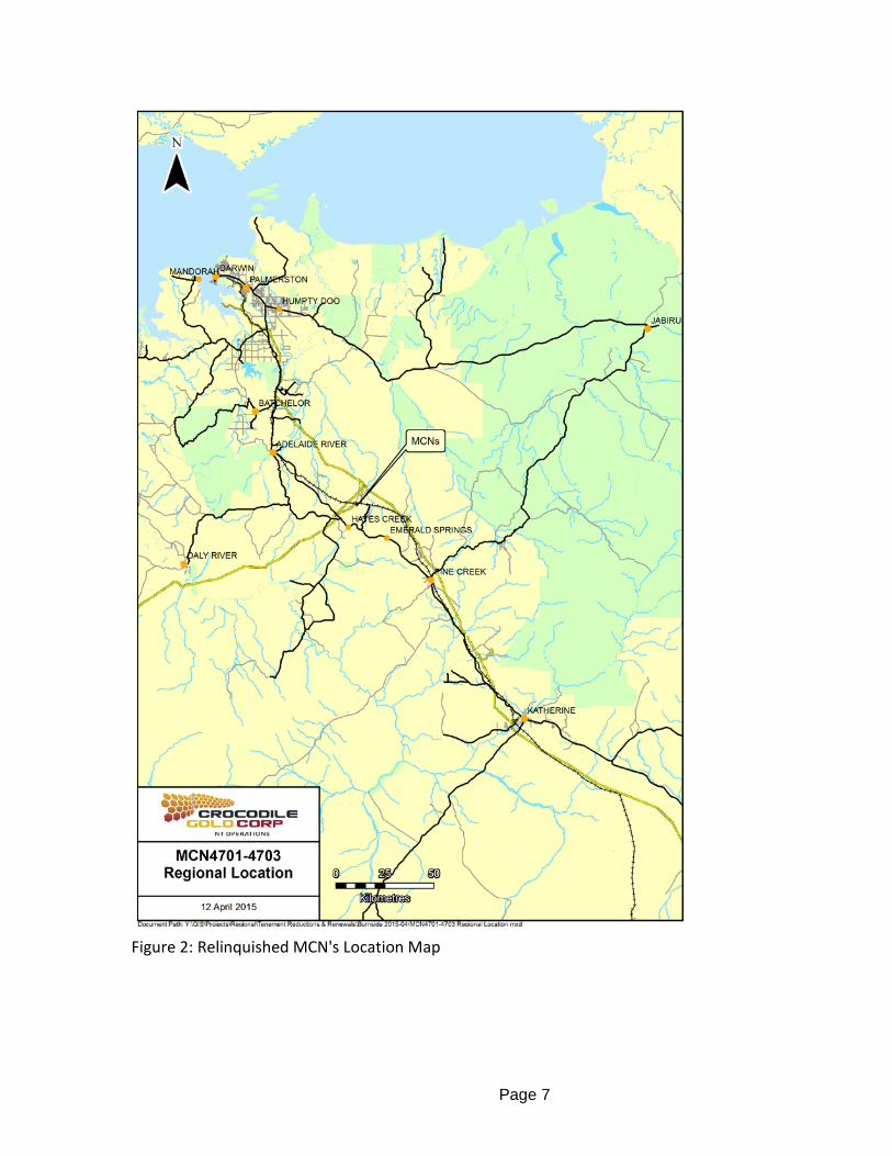
MCN4701, MCN4702 and MCN4703 are situated approximately 140km SE of Darwin
NT, and roughly 45Km northwest of the village of Pine Creek (Figure 2). Access is
gained by travelling approximately 160 km south from Darwin via the Stuart Highway,
then heading east along the Fountain Head Road for approximately 12 km.

Page 6
The tenement’s falls on the Pine Creek 1:250,000 scale map sheet and on the Batchelor
1:100,000 map sheet. The group of tenements are located on Douglas Station pastoral
lease, PL2683. The area consist of hills, flats and undulating terrain which generally
support tall and mixed open woodland with tall grassy understory (NSR, 1995).
Page 7
Figure 2: Relinquished MCN's Location Map
Page 8
5 TENEMENT DETAILS
The tenement details associated with the MCN’s can be viewed in Table 1, below. They
were consolidated between 1987 and 1995 by Cypress Gold Australia and Solomon
Pacific-Acacia Resources Pty Ltd. These MCN’s were a part of the original 26 MCN’s
which, with MLN1139 and another MLN made up the Brocks Creek Group.
A gold mill was commissioned by Solomon Pacific Resources NL in April of 1996, which
was used to process the ore from several open pit gold deposits within the area. The
company was subsequently acquired by Acacia Resource (a subsidiary of AngloGold
Australia), which continued open pit mining and exploration of the Brocks Creek area up
to April 2000. The area was then purchased by Buffalo Creek Mines P/L, a subsidiary of
Hill 50 Limited in November 2001.
During 2005, GBS Gold Australia Pty Ltd successfully made a takeover for Northern
Gold NL as well as purchased Harmony Gold’s 50% interest of the Burnside project
area. Full acquisition of the Burnside Project by GBS Gold Australia Pty Ltd occurred in
April of 2006.
Crocodile Gold Australia Pty Ltd received the liquidated mining lease application from
GBS Gold on November 9th 2009. However, the titles were transferred to the Company
until August 2011.
Tenement Area (ha) Area (2Kms) Grant Date Expiry Date MCN4701 32.40 0.36 5/11/1995 31/12/2014 MCN4702 36.00 0.36 5/11/1995 31/12/2014 MCN4703 36.00 0.30 5/11/1995 31/12/2014
Table 2: Tenement Details
6 GEOLOGICAL SETTING
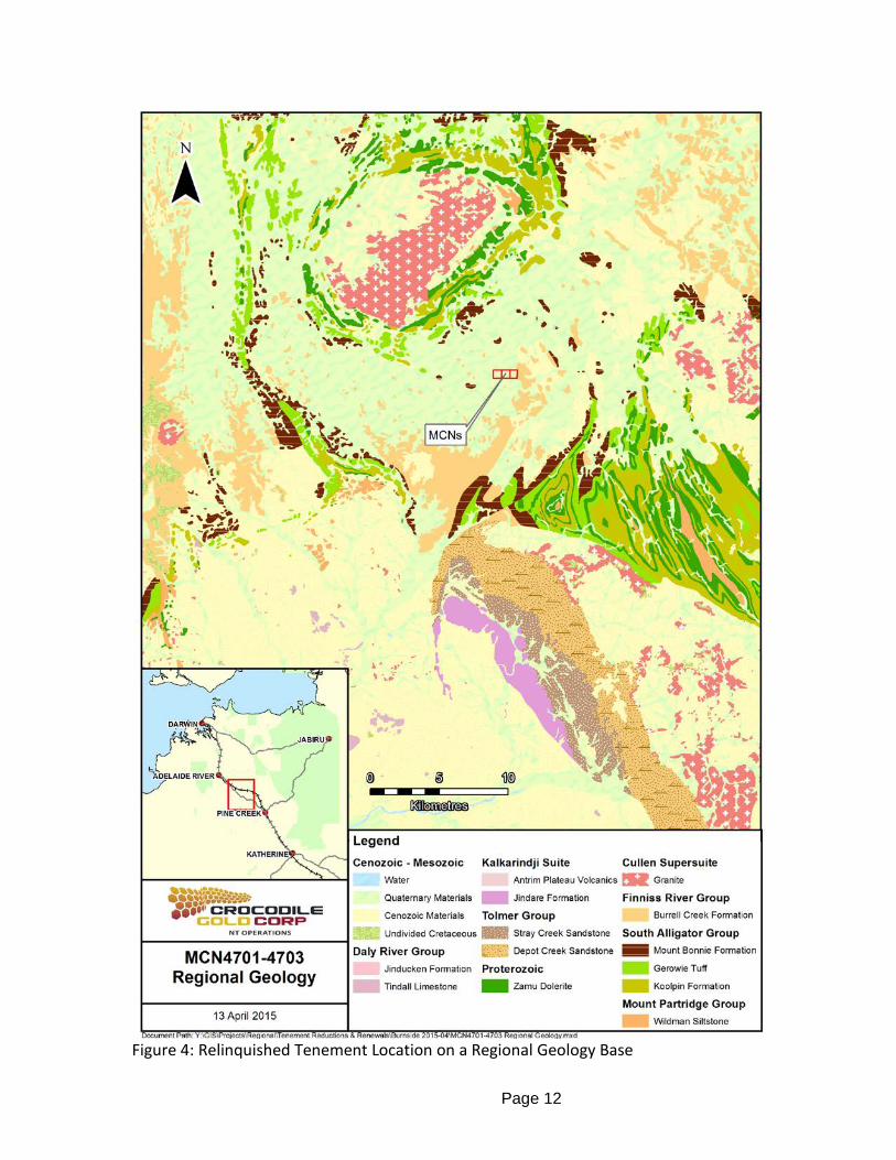
6.1 REGIONAL GEOLOGY Tenements of the Brocks Creek Project are located within the Pine Creek Orogen, a
tightly folded sequence of Palaeoproterozoic rocks, 10 to 14 km in thickness, laid down
on a rifted granitic Archaean basement during the interval ~2.2-1.87Ga (Ahmad et al.
1993). The sequence is dominated by pelitic and psammitic (continental shelf shallow
marine) sediments with minor inter-layered tuff units. Pre-orogenic mafic sills of Zamu
Dolerite intruded the sequence prior to regional metamorphism and deformation.
Page 9
During the Top End Orogeny (Nimbuwah Event ~1.87-1.85Ga) the sequence was tightly
folded and pervasively altered with metamorphic grade averaging greenschist facies to
phyllite. The Cullen Intrusive Event introduced a suite of fractionated calc-alkaline
granitic batholiths into the sequence in the period ~1.85-1.78Ga (Bajwah 1994). These
high temperature I-type intrusives induced strong contact metamorphic aureoles ranging
up to (garnet) amphibolite facies, and created more extensive biotite and andalusite
hornfels facies.
Less deformed Neo- to Meso-Proterozoic clastic rocks and volcanics have an
unconformable relationship to the older sequences. Flat lying Palaeozoic and Mesozoic
strata along with Cainozoic sediments and proto-laterite overlie parts of the Pine Creek
Orogen lithologies. Recent scree deposits occupy the lower hill slopes while fluviatile
sands, gravels and black soil deposits mask the river/creek flats areas.

Page 10
Figure 3: Stratigraphic Column, Pine Creek Orogen (Gillman et al, 2009)
Strata comprising of the Gerowie Tuff are the host rocks for gold mineralisation within
the Brocks Creek area. This unit contains a repetitious sequence of volcano-sedimentary
unit compromising argillite (siltstones/shales/schists) and silicified tuffs. The formation
has an apparent thickness of more than 500 meters and is the middle of three discrete
units comprising the South Alligator Group (Figure 3). These three formations, and the
overlying Burrell Creek Formation (part of the Finniss River Group), are host to many of
the significant gold deposits in the Pine Creek Inlier. The combination of formations has
been exposed to regional greenshist facies. This, in turn, has resulted in the
development of a northwest trending fabric. Consequential to this saw the unrestricted

Page 11
spread of felsic volcanism and the intrusion of granitods caused contacts
metamorphism, in aureoles between 500 metres and two kilometres wide that overprint
the earlier regional metamorphism. Following the granitoid intrusions, an extensive array
of northeast and northwest trending dolerite dykes (Zamu) intruded the metasedimentary
sequence during regional extensional deformation.
Gold mineralization within the Pine Creek Orogen is preferentially developed within
strata of the South Alligator Group and lower parts of the Finniss River Group along
anticlines, strike-slip shear zones and duplex thrusts located in proximity to the Cullen
Granite Batholith.
Upper and lower contacts between these four formations are gradational and
interdigitations are common, however, there is an angular unconformity at the base of
the Koolpin Formation. Subjacent to the unconformity is the Mount Partridge Group,
though it does not outcrop in the Brocks Creek area (Figure 4).
Page 12
Figure 4: Relinquished Tenement Location on a Regional Geology Base

Page 13
6.2 LOCAL GEOLOGY The tenement area is underlain a sequence of Palaeoproterozoic meta-sedimentary
rocks of the South Alligator Group and Finniss River Group, intruded by the Burnside
Granite (Figure 2). This rock sequence has been tightly folded on axes that trend north
westerly, and have been subjected to phyllitic - middle greenschist facies
metamorphism. Thermal effects from the post orogenic Burnside Granite that lies to the
northwest of the Group has imparted hornfelsing and porphyroblastic spotting of garnet,
biotite and andalusite/cordierite depending on lithology and proximity to the contact.
Calc-silicate hornfels is reported from some thermally higher grade areas. The granite
emplacement has also distorted and disrupted pre existing fold and fault patterns.
Figure 5: Local Geology and Location of Relinquished Tenements
Page 14
Rocks of the South Alligator Group comprise of the Koolpin Formation, Gerowie Tuff and
Mt Bonnie Formations, which host many of the gold occurrences in the Pine Creek
Orogen (Figure 5). The boundaries of the formations within South Alligator Group are
gradational while the lower contact of the Group is unconformable with the Mt Partridge
Group. The overlying Burrell Creek Formation is generally coarser with high energy
greywacke dominant units. This formation is also a significant host to gold deposits in
the Burnside and Pine Creek region.
Regionally, the South Alligator Group has been intruded and dilated by semi concordant
pre-orogenic sills of Zamu Dolerite. Only the Koolpin Formation appears to have been
intruded within the Brocks Creek project area. A tight WNW trending, shallow southeast
plunging, asymmetric fold structure termed the Brocks Creek-Zapopan (BKZ) anticline
has been subject to axial plane failure and thrust fault movement. It hosts the bulk of
gold mineralised occurrences in the immediate area. The association of gold with failed
anticlinal axial zones in South Alligator Group is common in the Pine Creek Orogen
(Shaw, 2005).
The Koolpin Formation (100m-500m) is typically thin to medium, bedded dark
carbonaceous pyritic mudstone-siltstone with rare iron formation and dolomitic horizons.
It represents low energy deposition in an anoxic basin and hosts the Cosmo Mine. This
formation is also a significant host to other gold and base metal deposits in the Burnside
and Pine Creek region.
The overlying Gerowie Tuff (200m-500m) comprises a cyclic silt-greywacke-arenite unit
with frequent alternations of thin cherty tuffite beds, and carbonaceous argillite. It
represents distal sub-aerial felsic volcanism feeding into a euxinic basin. The unit is
present at the Faded Lily, Burgan and Alligator gold deposits.
The Mt Bonnie Formation (150m-500m) is made up of cyclic siltstone, mudstone and
greywacke with thin pyritic chert horizons that are locally important host rocks at Brock
Creek. It represents slightly higher energy deposition and is a precursor to the high
energy greywacke facies of the Finniss River Group into which it grades conformably.
Burrell Creek Formation represented by lithic greywackes and siltstone-argillite is the
first formation resting gradationally on Mt Bonnie Formation and outcrops extensively to
the south of the BKZ. Regionally it is known to host gold mineralisation, but less
commonly than the Koolpin, Gerowie Tuff and Mt Bonnie Formations in the Burnside
Page 15
region. Nevertheless, the significant Union Reefs gold deposits are hosted by Burrell
Creek sediments
Late-stage biotite-lamprophyre and felsic porphyry dykes also cut the meta-sedimentary
sequence.
7 EXPLORATION ACTIVITIES PRE-2011
For the years prior to 2011, the MCN titles were held by other companies; a summary of
their work is outlined below:
Gold was first discovered in the Brock’s Creek area at the end of 1872 and was mainly
worked by the Chinese up until the turn of the 20th century. The mining techniques
consisted of alluvial mining, shafts, adits and small pits. By 1895 there were a number of
reef mining operations with a total population of 311 people at the Brock’s Creek
Township.
In 1935, 1936 and 1939, the Brock’s Creek area was mapped by the Aerial Geological
and Geophysical Survey of Northern Australia. Walpole (1968) also mapped the area in
his regional survey of the Pine Creek Geosyncline.
During the period of 1954 to 1956, the Brock’s Creek area was worked by Australian
Mining and Smelting Limited, whose main focus was on gold and the base metal
potential within the carbonaceous shales within the region. The area was then sold to
Enterprise Exploration Company Pty Ltd in 1957.
In 1967 the authority to prospect (AP1681) was held by Placer Prospecting Pty Ltd
which included the MCN’s 4701-4703. A geological assessment of the ore-bearing
potential, in conjunction with a geochemical study, was conducted over the AP during 18
May and 27 June, 1967. Results were seen to be discouraging.
Central Pacific Minerals was granted authority of AP1959 during the 1970’s, which
encompassed the MCN’s. Reconnaissance sampling was done over the area with the
work was documented in a series of monthly reports, which outlined the rock chip
sampling, radiometric readings and soil sampling.
In 1993 Cypress and Solomon Pacific formed a joint venture over the area with 75%
ownership going towards Cypress on January 5th, 1993. A drill program was carried out
within the same year, which saw 20 vacuum drill bedrock holes drilled within the
tenement areas. The results were poor, with the average grade being 0.5 g/t Au.
Page 16
Further drilling was conducted over the area during the 1998 drilling campaign
completed by Acacia Resources. This involved a total of 47 holes being drilled on the
tenement area.
On the 10th of November 1995, saw the transfer of titles from Cypress Gold Australia to
Solomon Pacific Resources NL.1995 MCN4689 application granted to AngloGold
Australia from Cypress Amax Australia.
The company was subsequently acquired by Acacia Resource (a subsidiary of
AngloGold Australia), which continued open pit mining and exploration of the Brocks
Creek area up to April 2000. The area was then purchased by Buffalo Creek Mines P/L,
(a subsidiary of Hill 50 Limited), who had equal shares in the mineral claims with
Territory Goldfields, in November 2001. The joint venture between Buffalo Mining P/L
and Territory Goldfields NL was known as the Burnside Joint Venture.
In 2004, a remote sensing study was conducted over the area by Burnside Joint
Venture, which accommodated the report writing.
During 2005, GBS Gold Australia Pty Ltd successfully took over Northern Gold NL as
well as purchased Harmony Gold’s 50% interest of the Burnside Project area. Full
acquisition of the Burnside Project by GBS Gold Australia Pty Ltd occurred in April of
2006.
7.1 EXPLORATION ACTIVITIES 2009- 31 DECEMBER 2014
No exploration activities were reported in 2009-2010 as Crocodile Gold took over the
titles from the receivers of GBS Gold.
From 2011 to 2014, exploration over the MCN’s included a complete review of the data
associated with the tenements as well as the collation of historic reports and maps
associated with the area. These reports and maps are now stored at the Brocks Creek
document library. No on ground exploration work was completed on these titles in the
time that Crocodile Gold owned them. These titles were part of regional deposit reviews
but no significant projects were generated on these leases hence why they have been
relinquished.
Page 17
8 REFERENCES
BAJWAH, Z.U., 1994. A contribution of geology, petrology and geochemistry to the Cullen Batholith and related hydrothermal activity responsible for mineralisation, Pine Creek Geosyncline, Northern Territory. Northern Territory Geological Survey Report 8. BAJWAH, Z.U., 2007. Annual Exploration Report EL 23270 “Woolwonga North” Year Ending 19 February 2007. GBS Gold Australia, Annual Report to the Northern Territory Department of Primary Industry, Fisheries and Mines, Darwin. Edwards, M., 2012. 2011 Annual Group Report (GR187/11) for the Burnside Mining Project Northern Territory Geological Survey Company Report. Edwards, M., 2013. 2012 Annual Group Report (GR185/12) for the Burnside Exploration Project Northern Territory Geological Survey Company Report. Edwards, M., Gerritsen, H., Muller, F.L., 2011, Report on the Mineral Resources & Mineral Reserves of the Northern Territory Gold and Base Metals Properties, For Crocodile Gold Corp, April 4th 2011. Pages 270 to 280. Gillman, A., Muller, F. Andrews, M., Gerritsen, H., (2009), Overview of the Geology Mineral Resources and Reserves and Exploration Potential of the Northern Territory Gold Properties (Burnside Gold and Base Metal Projects, Tom’s Gully Gold Project) Australia for Crocodile Gold Corp. Odessa Resources Pty Ltd Technical report ORL-09/100 (Version1) July 12, 2009 NSR, 1995. Brocks Creek Gold Project Draft Environmental Impact Statement- Main Report. Consultants Report for Solomon Pacific Resources N.L. by NSR Environmental Consultants Pty Ltd (unpubl. report) pp 73. SHAW J., 2005 Annual Exploration Report EL23270, Year ending 19th March 2005. For DBIRD and Burnside JV. SQUIRE R., VAN DEN OEVER P, 1996, Brocks Creek Project Report for Exploration on MLN’s 176 & 1139, MCN’s 4689-4697, 4701-4703, 4863-4871 & 4895-4899 For The Period 1 January 1995 – 26 June 1996, for DME and Burnside JV STUART-SMITH, PG., NEEDHAM, RS., Wallace, D.A., and Roarty, M.J., 1986. McKinlay River 1:100,000. Bureau of Mineral Resources Geology and Geophysics, Canberra. STUART-SMITH, PG., NEEDHAM, RS., BAGAS, L. AND WALLACE, DA., 1987, Pine Creek, Northern Territory, 1:100 000 geological map and explanatory notes. Bureau of Mineral Resources, Australia and Northern Territory Geological Survey. WILLS, J.K., 1977. Annual report on Burnside East. Company Exploration Report CR1977-0115, Department of Mines and Energy, Darwin (unpub).