(mineral exploration) -...
TRANSCRIPT
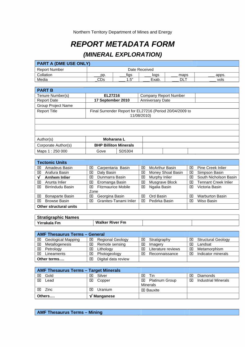
Northern Territory Department of Mines and Energy
REPORT METADATA FORM (MINERAL EXPLORATION)
PART A (DME USE ONLY) Report Number Date Received Collation ___pp. ___figs ___ logs ___ maps ___ apps. Media _CDs ___ 1.5” ___ Exab. ___ DLT ___ vols PART B Tenure Number(s) EL27216 Company Report Number Report Date 17 September 2010 Anniversary Date Group Project Name Report Title Final Surrender Report for EL27216 (Period 20/04/2009 to
11/08/2010) Author(s) Moharana L Corporate Author(s) BHP Billiton Minerals Maps 1 : 250 000 Gove SD5304 Tectonic Units Amadeus Basin Carpentaria Basin McArthur Basin Pine Creek Inlier Arafura Basin Daly Basin Money Shoal Basin Simpson Basin √ Arnhem Inlier Dunmarra Basin Murphy Inlier South Nicholson Basin Arunta Inlier Eromanga Basin Musgrave Block Tennant Creek Inlier Birrindudu Basin Fitzmaurice Mobile
Zone Ngalia Basin Victoria Basin
Bonaparte Basin Georgina Basin Ord Basin Warburton Basin Browse Basin Granites-Tanami Inlier Pedirka Basin Wiso Basin Other structural units Stratigraphic Names Yirrakala Fm Walker River Fm AMF Thesaurus Terms – General Geological Mapping Regional Geology Stratigraphy Structural Geology Metallogenesis Remote sensing Imagery Landsat Petrology Lithology Literature reviews Metamorphism Lineaments Photogeology Reconnaissance Indicator minerals Other terms…. Digital data review AMF Thesaurus Terms – Target Minerals Gold Silver Tin Diamonds Lead Copper Platinum Group
Minerals Industrial Minerals
Zinc Uranium Bauxite Others…. √ Manganese AMF Thesaurus Terms – Mining

Environmental impact surveys
Feasibility studies Geostatistics Metallurgy Ore reserves Resource assessment Mineral resources Mining geology Mine design Mine drainage Mine evaluation Pits Other terms…. AMF Thesaurus Terms – Geophysical Surveys Aerial magnetic surveys
Aerial radioactivity surveys
Aerial EM surveys Ground EM surveys Gravity surveys Geophysical
anomalies Gravity anomalies Bouger anomaly maps
Sirotem surveys Ground magnetic surveys
IP surveys Resistivity surveys Seismic surveys Magnetic anomalies Geophysical
interpretation Geophysical logs
Other terms….. Shuttle Radar Thematic Mapper AMF Thesaurus Terms – Geochemical Exploration – Surface SamplingGeochemical sampling Stream sediment
sampling Rock chip sampling Bulk sampling
Soil sampling Heavy mineral sampling
Geochemical anomalies
Assaying Isotope geochemistry Whole rock analysis X-Ray diffraction Sample location maps Other terms….. AMF Thesaurus Terms – Geochemical Exploration – Drill Sampling Diamond drilling RAB drilling Percussion drilling Air drilling RC drilling Rotary drilling Vacuum drilling Auger drilling Drill core Drill cuttings Drill hole logs Drill core analysis Other terms….. Drilling Type No. of Holes Hole Name(s) Diamond Percussion Vacuum RAB Auger Air core RC Rotary Other…. Mine/Deposit/Prospects Location – AMG Location - Datum Mines Deposits Prospects Other…

BHP Billiton Minerals Pty Limited
ABN 93 008 694 782
A member of the BHP Billiton Group
Final Surrender Report for EL27216 (Period 20/04/2009 to 11/08/2010)
Gove Special SD5304 Northern Territory
Datum/Zone: GDA94 / MGA Zone 53 Target Commodity: Manganese Date of Report: 17 September 2010
Title Holder: BHP Billiton Minerals Pty Ltd Project Operator: BHP Billiton Minerals Pty Ltd Prepared by: Lambodar Moharana ([email protected] ) Submitted by: Tim Richards ([email protected] ) Distribution: Department of Resources, NT Northern Land Council
BHP Billiton Information Research Centre

The Minerals Exploration Way
Final Surrender Report for EL27216 for the period from 20/04/2009 to 11/08/2010
LIST OF CONTENTS
SUMMARY ......................................................................................................................................... 1
1.0 INTRODUCTION.......................................................................................................................... 2
2.0 TENURE....................................................................................................................................... 2
3.0 PREVIOUS EXPLORATION........................................................................................................ 2
4.0 GEOLOGY ................................................................................................................................... 2
5.0 EXPLORATION WORK ............................................................................................................... 3
6.0 EXPLORATION EXPENDITURE................................................................................................. 3
7.0 REFERENCES............................................................................................................................. 3
List of Maps No. Title 1. Location Map...…………………………………………EL27216_LocationMap.pdf 2. Interpreted Lithology Map ........................................EL27216_LithologyMap.pdf
The Minerals Exploration Way
Final Surrender Report for EL27216 for the period from 20/04/2009 to 11/08/2010 Page 1 of 5
SUMMARY
EL27216 covers an area of 4.45 sq km (4 blocks) and is located in East Arnhem Land. It was not an original application but was created out of the larger EL24524 application. As this application is located within aboriginal freehold land, it was processed under the Aboriginal Land Rights Act. The site survey conducted by the Northern Land Council prior to grant resulted in creation of three non-contiguous consent lands. The largest of the three was retained as the main EL24524, but new tenement numbers, namely EL27216 and EL27217, were given to the other two consent lands. All three were granted simultaneously on 20 April 2009. EL27216, though very small in area, was accepted as part of a land package in the East Arnhem Land. The tenements are being explored for sediment-hosted supergene-enriched manganese within the Cretaceous rocks. The paleogeographic and stratigraphic setting of the Cretaceous rocks in East Arnhem Land are similar to that of Groote Eylandt, which hosts a world-class manganese deposit. Historical prospecting in East Arnhem Land undertaken during 1960’s had identified several manganese occurrences namely Peter John River, Caledon Bay and Lake Evella among others. The original EL24524 application, which included the current EL27216, was applied to explore the manganese potential at the Peter John River occurrence. Desktop interpretation of geology and ground reconnaissance work revealed that EL27216 was mainly covered with Proterozoic basement rocks and Quaternary coastal sediments. So it did not warrant any exploration per se and all the exploration efforts including airborne geophysical survey and drill testing were therefore confined to EL24524 only. A total of ~2.5 line kilometres in three flight lines have been ascribed to EL27216, which is only incidental to the airborne electromagnetic survey (1145 line kilometres) flown in May-June 2009 over parts of EL24524 (and adjacent EL4171). As such this data is inconsequential to EL27216 and hence has not been supplied separately with this report. The result of airborne electromagnetic survey and subsequent drill testing at a number of targets in the main EL24524 has completely downgraded the manganese potential of EL27216. Therefore it was decided to surrender the tenement in the second year itself.

The Minerals Exploration Way
Final Surrender Report for EL27216 for the period from 20/04/2009 to 11/08/2010 Page 2 of 5
1.0 INTRODUCTION
EL27216 is a small tenement covering 4.45 sq km (4 blocks) and is located in East Arnhem Land. It was not an original application but was created out of the larger EL24524 application. EL24524 was applied for by BHP Billiton Minerals Pty Ltd (BHPB) on 17 December 2004. As the application falls within aboriginal freehold land, it was processed under the Aboriginal Land Rights Act. A site survey was completed by the Northern Land Council prior to grant and the application area was divided into three non-contiguous consent areas and four non-contiguous non-consent areas. This resulted in creation of a total of 7 tenements. Tenement, EL24524, was retained for the largest area and EL27216 and EL27217 (refer EL27216_LocationMap.pdf attached) were the new tenements created to for the two smaller consent areas. All three were granted simultaneously on 20 April 2019. EL27216, though very small in area, was accepted as part of a land package in the East Arnhem Land. The tenement package is being explored for sediment-hosted supergene-enriched manganese hosted in Cretaceous rocks. The paleogeographic setting of this rock package is considered similar to that of Groote Eylandt which hosts a world-class manganese deposit. Historical prospecting undertaken during 1960’s in East Arnhem Land had identified several manganese occurrences like Peter John River, Caledon Bay, Lake Evella etc. The original EL24524, of which EL27216 was a part, was applied to explore for the manganese potential of the Peter John River occurrence. A combined annual report for EL’s 24524, 27216, 27217, 10182 and 27249 (all part of the ‘East Arnhem Land Project’) was submitted in May 2010. This is the final surrender report for life of EL27216 from 20 April 2009 to 11 August 2010.
2.0 TENURE
EL No Holder and Operator
Application Date
Grant Date Surrender Date
No of Blocks
Area in sq km
EL27216 BHP Billiton Minerals Pty Ltd.
17-Dec-2004 20-Apr-2009 11-Aug-2010 4 4.45
3.0 PREVIOUS EXPLORATION
Previous exploration over this area is described in Report 13 of the Northern Territory Geological Survey (Ferenczi, 2001). In the mid 1960’s, parts of the eastern Arnhem Land area was explored for sedimentary-diagenetic manganese after the discovery of the Groote Eylandt deposit. A variety of exploration campaigns were completed, including helicopter reconnaissance work, regional mapping, pitting and regional drilling at some prospects (e.g. Caledon Bay, Peter John River, Lake Evella).
4.0 GEOLOGY
Several areas of the East Arnhem Land are covered by Cretaceous transgressive marginal-marine and terrestrial units developed on an irregular basement terrain formed on resistant Precambrian sediments. The Cretaceous strata are often covered by remnants of a regional laterite profile that forms a distinctive flat plateau surface. The two main Cretaceous units are the upper Yirrakala Formation and lower Walker River Formation. The Yirrakala Fm is mainly thick-bedded marginal marine or terrestrial sandstone. The Walker River Fm is mainly marine

The Minerals Exploration Way
Final Surrender Report for EL27216 for the period from 20/04/2009 to 11/08/2010 Page 3 of 5
quartzose sandstone and interbedded clayey-siltstone, resting upon terrestrial basal conglomerate. The rocks are generally flat-lying with some locally moderate dips due to reactivation tectonics. The geologic and paleogeographic settings are similar to those on Groote Eylandt which hosts a world-class manganese deposit. Therefore East Arnhem Land is considered highly prospective for the Groote Eylandt style sedimentary-diagenetic manganese mineralisation.
5.0 EXPLORATION WORK
A desktop interpretation of the geology using available published geological maps and Landsat images was first completed as part of the regional targeting work. Some amount of ground truthing was also attempted using existing roads. It was found that EL27216 was covered mainly with Proterozoic basement rocks and Quaternary coastal sediments (refer to EL27216_LithologyMap.pdf attached). As such the geology was considered un-prospective for hosting manganese mineralisation. So it did not warrant any exploration per se and all the exploration efforts including airborne geophysical survey and drilling testing were therefore directed to EL24524 only. A total of ~2.5 line kilometres in three flight lines have been ascribed to EL27216, which is only incidental to the airborne electromagnetic survey (1145 line kilometres) flown in May-June 2009 over parts of EL24524 (and adjacent EL4171). As such the data is inconsequential to EL27216 and hence has not been supplied separately with this report. The result of airborne electromagnetic survey and follow up drill testing at a number of targets in the main EL24524 has completely downgraded the manganese potential in EL27216. Therefore it was decided to surrender the tenement early on in the second year itself.
6.0 EXPLORATION EXPENDITURE
An amount of $4,500 was expended towards exploration activities in EL27216. The Expenditure Report in the format prescribed for Northern Territory Exploration Expenditure for Mineral Tenement has been submitted separately. 7.0 REFERENCES
Ferenzi P.A., 2001, Iron Ore, Manganese and Bauxite Deposits of the Northern Territory, Northern Territory Geological Survey Report No. 13. White M., 2005, Evaluation of Data and Manganese Exploration Targets in the Groote Eylandt, Arnhem Land and SW Gulf of Carpentaria Regions, Australia. BHPB in-house Report No. Ex10814 (unpublished).

650000
650000
660000
660000
670000
670000
680000
680000
690000
690000
8630
000
8630
000
8640
000
8640
000
8650
000
8650
000
8660
000
8660
000
8670
000
8670
000
8680
000
8680
000
N.T.
Location Map
³
Minerals ExplorationAustralia & South Asia Region
Map ID:
Author:Date:Scale Figure No:GDA 1994 MGA Zone 53
EL27216_1_LocationMap.mxd
15/09/2010L Moharana
1 : 250,0001
East Arnhem Land Project
Map showing location of EL27216(Base - 1:250,000 Topo Map)
0 5 102.5
km
EL27216EL24524
EL27217
LegendEL27216EL24524 and EL27217
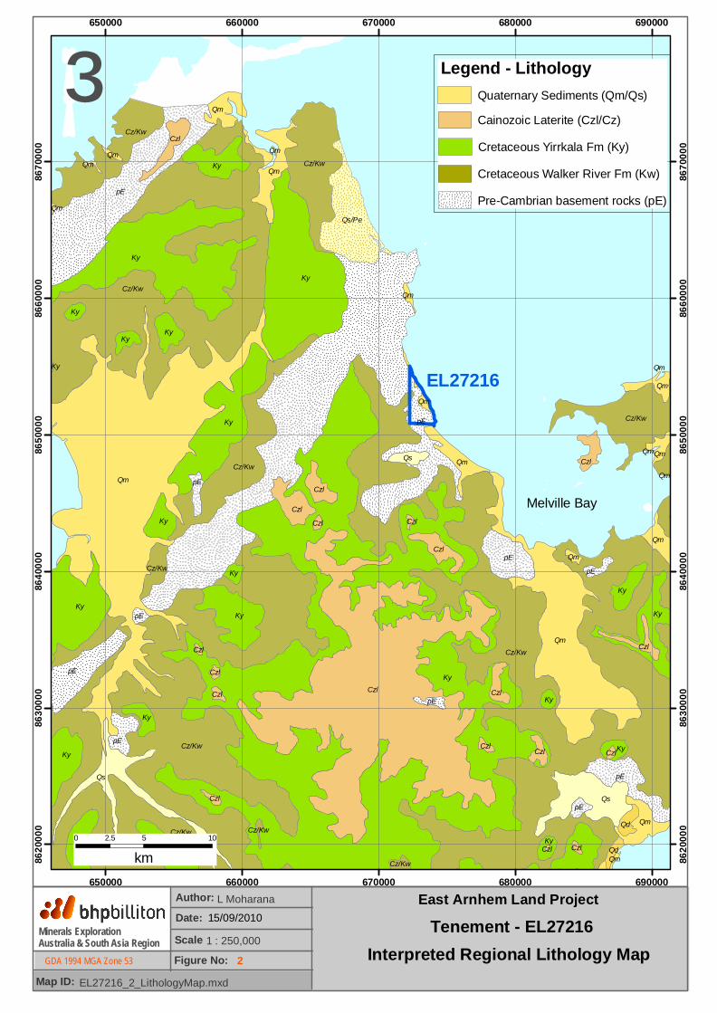
KyCzl
pE
Qm
Cz/Kw
Cz/Kw
Cz/Kw
Ky
Ky
pE
Qm
Ky
Cz/Kw
Ky
Qs
Qs
KyKy
Cz/Kw
pE
Cz/Kw
pE
pE
Cz/Kw
Cz/Kw
Qs/Pe
Ky
Ky
Ky
Qm
Ky
KyCzl
Ky
Qm
Ky
pE
Qm
Qm
Czl
Czl
Ky
Czl
Qm
Czl
Qm
Czl
Ky
pE
Qs
Qd
Ky
Ky
Ky
pE
pE
Ky
pE
Czl
Ky
Cz/Kw
Czl
Qm
pE
Qd
Qm
Czl
Czl
Czl
Qm
Qm
Czl
Cz/Kw
Czl
Czl
Qm
Czl
Czl
Qm
Cz/Kw
Czl
Qm
Qm
Ky
Czl
Qm
Qm
Qm
Qm
650000
650000
660000
660000
670000
670000
680000
680000
690000
690000
8620
000
8620
000
8630
000
8630
000
8640
000
8640
000
8650
000
8650
000
8660
000
8660
000
8670
000
8670
000
³
Minerals ExplorationAustralia & South Asia Region
Map ID:
Author:Date:Scale Figure No:GDA 1994 MGA Zone 53
EL27216_2_LithologyMap.mxd
15/09/2010L Moharana
1 : 250,0002
East Arnhem Land Project
Interpreted Regional Lithology Map
0 5 102.5
km
EL27216
Legend - LithologyQuaternary Sediments (Qm/Qs)Cainozoic Laterite (Czl/Cz)Cretaceous Yirrkala Fm (Ky)Cretaceous Walker River Fm (Kw)Pre-Cambrian basement rocks (pE)
Tenement - EL27216
Melville Bay