final report west byronwestbyronproject.com.au/.../2011/10/final-report-west-byron.pdf · the...
TRANSCRIPT

Jacqueline Collins (Consultant Archaeologist) 11 Camden Head Road Dunbogan NSW 2443
PROPOSED WEST BYRON URBAN RELEASE AREA, BYRON BAY, BYRON SHIRE NSW
_______________________________________ Cultural heritage assessment
December 2010
Prepared for: Byron Bay West Landowners Association PO Box 3369 Tuggerah NSW 2259

Proposed West Byron Urban Release Area, Byron Bay, NSW- Cultural heritage assessment _____________________________________________________________
_____________________________________________________________ Page 2
TABLE OF CONTENTS
EXECUTIVE SUMMARY 4 1 INTRODUCTION 1.1 Purpose and scope of this assessment 9 1.2 The study area 9 1.3 Potential future development 9 1.4 Assessment personnel 11 2 ENVIRONMENT AND LANDUSE EFFECTS 14 3 ABORIGINAL INVOLVEMENT AND CONSULTATION 3.1 Compliance with the Guidelines for Aboriginal Cultural Heritage Assessment and Community Consultation 3.1.1 Notification and registration of interests 18 3.1.2 Assessment methodology 19 3.1.3 Drafting, review and report finalisation 19 3.2 Native title claims 19 3.3 Stakeholder involvement 19 3.4 Aboriginal cultural heritage vales and issues 20 4 ABORIGINAL HERITAGE CONTEXT 4.1 Cultural background 21 4.2 Registered sites 4.2.1 DECCW Aboriginal Heritage Information Management System 22 4.2.2 Other heritage registers 24 4.3 Past archaeological surveys 4.3.1 Within the study area 24 4.3.2 Outside but near the study area 24 4.4 Archaeological potential of the study area 4.4.1 Potential site types 25 4.4.2 Predictive model of Aboriginal site location 26 5 NON-INDIGENOUS HERITAGE CONTEXT 5.1 Historic background 27 5.2 Registered sites 28 5.3 Other heritage records and information 28 5.4 Past heritage assessments 28 5.5 Potential heritage items in the study area 29 6 FIELD SURVEY 6.1 Method and procedure 29 6.2 Coverage 30 6.3 Results 6.3.1 Aboriginal heritage sites 32 6.3.2 Non-Indigenous heritage sites 33 7 STATUTORY CONTEXT 7.1 Aboriginal heritage- NSW NPW Act 1974 35 7.2 Non-Indigenous heritage- NSW Heritage Act 1977 35 7.3 NSW Environmental Planning and Assessment Act 1979 36 7.4 The study area 36 8 SIGNIFICANCE ASSESSMENT 8.1 Aboriginal cultural heritage 8.1.1 Aboriginal social/cultural significance 37 8.1.2 Scientific/archaeological significance 37 8.1.3 Shell midden: Byron Bay Urban Areas 3 (#4-5-104) 37 8.1.4 Balance of the study area 38

Proposed West Byron Urban Release Area, Byron Bay, NSW- Cultural heritage assessment _____________________________________________________________
_____________________________________________________________ Page 3
8.2 Non-Indigenous cultural heritage 8.2.1 Assessment criteria 38 8.2.2 WB H-1 and WB H-2: Building remnants 38 8.2.3 WB H-3: Belongil Union Drain 38 9 POTENTIAL DEVELOPMENT IMPACTS AND MITIGATION STRATEGIES 9.1 Aboriginal cultural heritage 9.1.1 Shell midden: Byron Bay Urban Areas 3 (#4-5-104) 39 9.1.2 Balance of the study area 40 9.1.3 Other issues 40 10 MANAGEMENT RECOMMENDATIONS 10.1 Aboriginal cultural heritage 42 10.2 Non-Indigenous cultural heritage 43 REFERENCES 44 GLOSSARY 47 APPENDIX A Aboriginal stakeholder correspondence 50 TABLES 1 Sites registered on the DECCW AHIMS database within one kilometre of the study area 22 2 Environmental context of survey units 30 3 Effective coverage data 32 4 Gradings of significance advocated by Heritage Branch, NSW Department of Planning 39 FIGURES 1 General location of the study area, west Byron Bay 10 2 Study area land titles 11 3 Draft development structure plan 12 4 Proposed zoning 13 5 Study area landforms 15 6 Aboriginal sites registered on DECCW AHIMS database within the study locality 23 7 Survey units, land covered during the survey, and location of recorded sites and area of potential further sensitivity 31 8 Draft development structure plan, showing indicative locations of the recorded Aboriginal midden and area of potential further sensitivity 41
Proposed West Byron Urban Release Area, Byron Bay, NSW- Cultural heritage assessment _____________________________________________________________
_____________________________________________________________ Page 4
EXECUTIVE SUMMARY A 108 hectare land parcel at west Byron Bay on the NSW north coast has been identified by the NSW Minister for Planning as a potential State Significant Site under Schedule 3 of State Environmental Planning Policy (Major Development) 2005. This report was prepared for the Byron Bay West Landowners Association, and forms the cultural heritage component of a State Significant Site (SSS) study for the land parcel, which is earmarked as a potential urban release area. The cultural heritage assessment addresses NSW Department of Planning requirements in relation to preparation of the SSS study, and includes Aboriginal stakeholder involvement and consultation, literature review, heritage register searches, field survey to identify potential cultural heritage impacts of any future urban development, and management recommendations aimed at avoiding or mitigating future development effects.
Environmental context The study area is located on the coastal plain at west Byron Bay, four kilometres west of Cape Byron and a minimum of 750 metres south of Belongil Beach. It is dominated by a low, level to gently undulating beach ridge plain based on highly acid Pleistocene dune sands. In addition to vegetation clearance and on-going slashing, long-term stock grazing, drain excavation, and some residential development, a substantial proportion of the beach ridge plain has been affected/modified by other past and present landuses, including the construction of formed and unformed roads, development and operation of a caravan park and a former motor wreckers, and construction and use of industrial sheds. Lowlands comprising mixed Pleistocene/Holocene alluvial and aeolian sand deposits encroach into the southern and eastern parts of the study area. The lowlands have been disturbed by vegetation clearance/slashing, drain construction, and stock trampling/grazing, as well as some residential development. Surviving natural vegetation on the study area lowlands is dominated by regrowth Broad-leaved Paperbark forest. This type of forest occurs extensively across the Belongil-Cumbebin Swamp wetlands beyond the southern and eastern study boundaries. Aboriginal involvement and consultation outcomes Six Aboriginal stakeholders/stakeholder groups registered an interest in this assessment as a result of implementation of the Guidelines for Aboriginal Cultural Heritage Impact Assessment and Community Consultation. One of these subsequently withdrew their stakeholder interest. A pedestrian field survey of the study area was undertaken with the assistance of Tweed-Byron Local Aboriginal Land Council (TBLALC) sites officer Cyril Scott and Burabi Aboriginal Corporation spokesperson Lois Cook. The detailed survey was followed-up by reconnaissance inspections with Ngaraakbul/Gindavul Elder Harry Boyd and Arakwal Aboriginal Corporation CEO Yvonne Stewart. Aboriginal cultural heritage issues and values, potential impacts of any future urban development on these values, and preferred impact mitigation strategies were discussed on-site with these stakeholders/stakeholder representatives, and off-site with Ngaraakbul Elder Roy Williams. Although a number of sites/places of traditional ceremonial, mythological or otherwise sacred/spiritual significance and on-going socio-cultural attachment and concern occur in and near Byron Bay, the TBLALC, Arakwal Aboriginal Corporation, Harry Boyd and Lois Cook advised that none of these are located within the study area. These stakeholders advised that they have no fundamental objections to the proposed future urban development, providing the floodplain forests within the south-eastern extremity of the study area (east of the Belongil Union Drain) and south of the study boundary are conserved, and the management recommendations presented in this report are implemented. Correspondence from the TBLALC, Arakwal Aboriginal Corporation and Lois Cook in response to their review of a draft of this report is reproduced in Appendix A. Although verbally supporting the draft recommendations, no written correspondence has been received from Harry Boyd to date.
Stakeholder Roy Williams advised that the whole of Australia constitutes traditional Aboriginal land and is thus of cultural value and attachment, irrespective of whether or not it contains archaeological sites or remembered sites/places of ceremonial, mythological or otherwise sacred/spiritual significance. Roy Williams regards the Byron Bay area to have a particularly high level of cultural sensitivity, and cited the existence of a traditional songline/dreaming route (also known to the other stakeholders) that extends inland from Julian Rocks (2.5 kilometres north of Byron Bay and thus well north of the study area) as a prime example of this sensitivity. During a follow-up phone call to his brother Doug Williams made at the request of Roy Williams, Doug Williams expressed a concern that ancestral burials may occur in the study area. Roy Williams elected not to provide a written or formal verbal comment on the adequacy or otherwise of the draft report or recommendations. Native Title claims The study area lies within a wider area subject of a registered Native Title claim lodged by the Byron Bay Bundjalung People (represented by the Arakwal Aboriginal Corporation). This Native Title claim does not include freehold land or areas where Native Title has been extinguished (by roads, public works or certain leases). As advised by Matthew Punch, Future Acts Solicitor for the Native Title Services Corporation, it appears unlikely that any formal native title processes under the Native Title Act 1993 would be applicable to the study area.
Proposed West Byron Urban Release Area, Byron Bay, NSW- Cultural heritage assessment _____________________________________________________________
_____________________________________________________________ Page 5
Heritage registers Searches of the DECCW Aboriginal Heritage Information Management System (AHIMS), Commonwealth and National Heritage Lists, Register of the National Estate, NSW State Heritage Register, the National Trust of Australia (NSW) Register, and heritage schedules of the North Coast Regional Environmental Plan and Byron Shire Local Environmental Plan revealed one registered site within the study area. This is an Aboriginal midden scatter (‘Byron Bay Urban Areas 3’) registered as site #4-5-104 on the DECCW AHIMS database. Field survey Due to the expected distribution and types of archaeological sites and the limitations imposed by surface vegetation and landuse processes, a selective survey strategy was adopted to maximise coverage of largely unmodified elevated sections of the beach ridge plain. The Belongil basin lowlands and substantially modified and lower, poorly drained sections of the beach ridge plain were sampled. A general wide-area reconnaissance was additionally undertaken to locate and inspect any mature trees for signs of Aboriginal marking/scarring, and any sites or items of potential non-Indigenous heritage value. Approximately 57 percent of the study area was covered during the survey. Once the constraints imposed by vegetation cover and modern land modification are taken into account, it is estimated that 14.7 percent of the surveyed land was effectively searched for surface evidence, including 12.4 percent of the total beach ridge plain and 1.6 percent of the total Belongil basin lowlands. Given the study area’s topography and disturbance history, the amount of ground covered on foot, and the environmental context of land that provided useable exposures, the effective survey sample is considered to have been satisfactory for the purposes of assessing the nature and extent of the archaeological resource. Survey results and assessment No previously unregistered Aboriginal sites were detected during the survey. The Byron Bay Urban Areas 3 (#4-5-104) midden was re-located, and information recorded to supplement that gathered during a 1991 sample survey of the study area. Three sites/items of potential non-Indigenous (historic) heritage value were also recorded. These comprise building remnants (designated WB H-1 and WB H-2) and a drainage channel (WB H-3). Aboriginal heritage sites When recorded in 1991, the Byron Bay Urban Areas 3 (#4-5-104) midden comprised two disturbed, low density surface scatters of fragmented and weathered pipi shell, located adjacent to buildings on the crest of a low dune (a former motor wreckers site) near Belongil Creek, in the north-eastern section of the study area (Lot 1 DP 780242). These results were confirmed by the present survey, in that the low-density surface shell scatters were again found to be confined to the same two locations, separated by sand exposures (including exposures of subsurface sediments around building foundations) containing no shell or other archaeological materials. Probing with a thin metal rod within, around and between the shell scatters failed to detect any evidence for a subsurface shell deposit. No stone, bone, charcoal or other shell species were identified on site #4-5-104 in 1991. The present survey extended the past findings through the recording of three fragments of mud whelk shell and two unmodified stone flakes on ‘Scatter 2’, close to the boundary between Lot 1 DP 780242 and the Belongil Fields Conference and Holiday Centre (Lot 2 DP 542178). In addition to the importation of coastal pipi shells, this evidence demonstrates some (minor) exploitation of estuarine shellfish (probably from nearby Belongil Creek), and the transport of stone materials, most likely collected in pebble form from Belongil Beach. The evidence at hand suggests that the midden is highly disturbed, largely (if not entirely) confined to the surface, contains a low density and diversity of cultural materials, and is unlikely to offer research information above that presented in this report. While the midden is provisionally assessed to be of low socio-cultural and scientific/archaeological significance, archaeological test excavations directed towards establishing the presence/absence of subsurface deposits would be necessary to provide information for a more definitive significance assessment of this site. Although not considered to warrant recording as a potential archaeological deposit (PAD), the southern margin of the beach ridge plain south and south-east of the Belongil Fields Conference and Holiday Centre was recognised as a place with some (albeit reasonably low) potential to contain subsurface materials. A precautionary approach to any future development disturbance of this area is called for, particularly in light of the ‘due diligence’ requirements legally enforced under the National Parks and Wildlife Amendment Act 2010. Non-Indigenous heritage items WB H-1 is located in the central eastern section of Lot 1 DP 542178, and comprises the remnants of a demolished building, probably once used as a horse stable or pig pen. The surviving material evidence includes concrete foundations around the perimeter of a large open rectangular enclosure, topped with up to three courses of dry-pressed, kiln-fired bricks; and an adjacent concrete water trough and two corrugated iron rain-water tanks. WB H-2 is located approximately 50 metres east of WB H-1, also in the eastern section of Lot 1 DP 542178, and is believed to represent the vestiges of a pig pen, probably constructed during the mid-1900s. The site comprises remnant concrete masonry (Besser Block) wall sections surrounding a concrete slab floor; an associated concrete feeding trough, and piles of demolished building refuse.

Proposed West Byron Urban Release Area, Byron Bay, NSW- Cultural heritage assessment _____________________________________________________________
_____________________________________________________________ Page 6
The WB H-1 and WB H-2 building remnants relate to the local historical theme of ‘agriculture, dairying and related industry’. Neither site is assessed to be of either local or State heritage significance under any of the assessment criteria advocated by the NSW Heritage Office (2001). WB H-3 comprises the Belongil Union Drain, which runs through Belongil-Cumbebin Swamp and traverses the south-eastern extremity of the study area before continuing north to empty into Belongil Creek. The drain was dug by hand in 1913 to facilitate agricultural expansion but has since been modified (deepened and widened) and regularly maintained by mechanical excavators. The drain relates to the local historical theme ‘agriculture, dairying and related industry’. Although demonstrating the principal characteristics of a class of the local area’s cultural places (early 20th century drainage channels) (NSW Heritage Office assessment criterion (g)), modern alterations detract from its historical significance such that the short section of the drain encompassed within the south-eastern section of the study area is not assessed to be of sufficient significance to warrant either local or State heritage listing. Potential development impacts and mitigation strategies Aboriginal cultural heritage Shell midden: Byron Bay Urban Areas 3 (#4-5-104) The identified surface midden scatter lies within an area earmarked for general residential use (R1 zoning) under the draft development structure plan. Although provisionally assessed (on the basis of the available survey data) to be of low socio-cultural and scientific/archaeological significance, subsurface archaeological testing would be required to provide information to more securely assess the significance of this site and to determine appropriate development controls (including the establishment of any heritage conservation area that may prove warranted if significant subsurface deposits are identified). Balance of the study area No other Aboriginal archaeological sites/materials or specific PADs were identified during the assessment. Whilst it is anticipated that at least some dispersed archaeological materials would have been detectable on the disturbed surface of the beach ridge plain in the event of any substantial occupation site occurring, the possibility for significant subsurface Aboriginal cultural heritage materials on this overall aggrading landform cannot be ruled out. This is especially the case along the comparatively well elevated southern margin of the beach ridge plain south and south-east of the Belongil Fields Conference and Holiday Centre (spanning Lots 227 and 229 DP 755695, and Lot 9 DP 111821), which lies within the area proposed for general residential use (R1 zoning) under the draft development structure plan. It is considered that subsurface archaeological testing should be undertaken on this section of the plain to more conclusively establish archaeological and socio-cultural values, and to determine appropriate development controls (including the establishment of any heritage conservation area that may prove warranted if significant subsurface deposits are identified). Other issues TBLALC and Arakwal Aboriginal Corporation representatives, and stakeholders Harry Boyd and Lois Cook advised that future urban development of the study area would not affect any known sites/places of ceremonial, mythological or otherwise sacred/spiritual significance, and that providing the existing Belongil-Cumbebin Swamp floodplain forests and their biodiversity are conserved and maintained as proposed, this development would not compromise the contemporary socio-cultural values attributed to the natural environment. There is no evidence to suggest that the traditional songline//dreaming route that traverses the Belongil locality inland from Julian Rocks veers south into or near the study area. Concerns expressed by Doug Williams regarding the potential for ancestral burials are not without foundation. However, in the absence of any known historic massacres of Aboriginal people or historic burials within the study area, this same potential equally applies to all reasonably intact sand-based grounds in and around west Byron, where past and present development activities (and archaeological investigations) have failed to identify burial remains off midden deposits. Cultural preference aside, the strongly acid sands are not conducive to the preservation of organic materials, and burials are unlikely to survive unless of relatively recent (historic) age or within a midden deposit of sufficient size/depth to provide localised alkaline soil conditions. The recommended test excavations on site #4-5-104 would reveal the potential for this midden to preserve subsurface organic materials, including burials. Even if Aboriginal burials do survive elsewhere in the study area, it is not possible to predict their location, nor is it likely to be possible to conclusively detect burials using non-invasive technologies (eg ground penetrating radar). As such, the only realistic strategies available for mitigating development impacts on ancestral burials are Aboriginal stakeholder monitoring of all ground disturbance, and/or the stop-work conditions applicable to all Aboriginal objects. In light of the expected low survival potential for burials, it is concluded that the stop-work conditions to be included in the recommended Cultural Heritage Management Plan offer the most appropriate means of mitigating development-related impacts.
Management recommendations Management recommendations presented in this report are designed to ensure that the proposed future landuses appropriately respond to and include strategies aimed at avoiding or mitigating adverse effects on the cultural environment. Depending on the results of the recommended test excavations (cf Recommendations 1 and 2) and the significance of any unexpected finds revealed during the course of future development activities, it may prove necessary to establish and maintain open space heritage

Proposed West Byron Urban Release Area, Byron Bay, NSW- Cultural heritage assessment _____________________________________________________________
_____________________________________________________________ Page 7
conservation areas in addition to the environmental conservation areas proposed in the draft structure plan. Aboriginal cultural heritage Recommendation 1 (shell midden: Byron Bay Urban Areas 3 [#4-5-104]):
Archaeological test excavations (directed by an appropriately qualified archaeologist, assisted by nominated Aboriginal stakeholder representatives) should be undertaken on and around the registered Byron Bay Urban Areas 3 (#4-5-104) midden (Lot 1 DP 780242) to more securely assess its cultural heritage values and to define any parts of this site (if any) that would warrant conservation in the development-related context. The requirement for subsurface archaeological testing should be written into any development control plan relating to Lot 1 DP 780242. A report detailing the method, procedure, results and recommendations of the investigation should be required to accompany any future development application that incorporates the midden locality.
In the event that the proposed development of the study area (specifically Lot 1 DP 780242) is accepted for assessment under Part 3A of the EP&A Act, an Aboriginal Heritage Impact Permit (AHIP) under Part 6 of the National Parks and Wildlife Act 1974 would not be necessary. DoP requirements and directives would instead need to be observed and implemented. In all other circumstances, the legislative conditions of the National Parks and Wildlife Act 1974 would apply, including the requirement for an AHIP to authorise the test excavations and any subsequent site/artefact salvage and/or destructive activities on or near the #4-5-104 midden. Recommendation 2 (area of potential further archaeological sensitivity marked on Figures 7 and 8 of this report):
Archaeological test excavations (directed by an appropriately qualified archaeologist, assisted by nominated Aboriginal stakeholder representatives) should be undertaken along the southern margin of the beach ridge plain spanning Lots 227 and 229 DP 755695, and Lot 9 DP 111821 (as marked on Figures 7 and 8 of this report) to more securely assess its cultural heritage values and to define any parts of this landform (if any) that would warrant conservation in the development-related context. The requirement for subsurface archaeological testing should be written into any development control plan relating to Lots 227 and 229 DP 755695, and Lot 9 DP 111821. A report detailing the method, procedure, results and recommendations of the investigation should be required to accompany any future development application that incorporates any of these properties.
It is considered that small-scale test excavations consistent with the ‘Code of Practice for Archaeological Investigation of Aboriginal Objects in NSW’ (DECCW 2010) would be sufficient to effectively assess the archaeological context and cultural heritage values of the potentially sensitive southern margin of the beach ridge plain. As per 2010 amendments to the National Parks and Wildlife Act 1974 and regulations, an AHIP would not be necessary ahead of these test excavations, providing the ‘Code of Practice for Archaeological Investigation of Aboriginal Objects in NSW’ is strictly followed. Unless the proposed development of the study area (specifically Lots 227 and 229 DP 755695, and Lot 9 DP 111821) is accepted for assessment under Part 3A of the EP&A Act (in which case DoP requirements and directives would need to be observed and implemented), an AHIP would be required to authorise any comprehensive follow-up archaeological investigation/salvage and/or destructive activities on or near any site identified during the initial test excavations.
Recommendation 3: Irrespective of the Aboriginal consultation and involvement undertaken during the present assessment and the low likelihood of any additional stakeholders being identified, it is recommended that the ‘Aboriginal Cultural Heritage Consultation Requirements for Proponents’ (DECCW 2010) be implemented in relation to any AHIP application/s seeking authorisation to investigate, salvage, or otherwise disturb and/or destroy Aboriginal objects within the study area. Recommendation 4: Following the reporting and assessment of archaeological test excavations on and around the registered Byron Bay Urban Areas 3 (#4-5-104) midden (Recommendation 1) and along the southern margin of the beach ridge plain (Recommendation 2), a Cultural Heritage Management Plan (CHMP) should be devised in consultation with the Aboriginal stakeholders to establish actions and principles to be adopted for the identification, protection and management of Aboriginal objects and values within the proposed development area. The CHMP should address and include (but not necessarily be limited to): • The recommendations arising from archaeological test excavations (Recommendations 1 and 2); • Details as to any further actions required to comply with DoP, DECCW and/or Byron Shire Council approval
conditions; • A strategy for the salvage and curation of salvaged objects, giving consideration to measures for managing and
housing any such objects; • Specific measures to be applied to development and associated activities to identify and avoid unmitigated impacts
on Aboriginal cultural heritage resources, including a component within the pre-start induction to be attended by all on-site workers that details Aboriginal heritage legislation and penalties for non-compliance, exclusion requirements with respect to any heritage conservation areas, and stop-work conditions to be followed in the event that any identified or potential Aboriginal cultural heritage sites/objects (including burials) are detected during any stage of the works.

Proposed West Byron Urban Release Area, Byron Bay, NSW- Cultural heritage assessment _____________________________________________________________
_____________________________________________________________ Page 8
Non-Indigenous cultural heritage Recommendation 5:
To avoid unmitigated impact on cultural heritage resources, the Cultural Heritage Management Plan (CHMP; Recommendation 4) should concurrently include actions and principles to be adopted for the identification, protection and management of non-Indigenous sites/relics within the proposed development area. With respect to non-Indigenous cultural heritage, the CHMP should address and include (but not necessarily be limited to): • Details as to any further actions required to comply with DoP and/or Byron Shire Council approval conditions; • Specific measures to be applied to development and associated activities to identify and avoid unmitigated impacts
on non-Indigenous cultural heritage resources, including a component within the pre-start induction to be attended by all on-site workers that details non-Indigenous heritage legislation and penalties for non-compliance, exclusion requirements with respect to the environmental conservation areas, and stop-work conditions to be followed in the event that any identified or potential non-Indigenous heritage sites/items are detected during any stage of the works.

Proposed West Byron Urban Release Area, Byron Bay, NSW- Cultural heritage assessment _____________________________________________________________
_____________________________________________________________ Page 9
1 INTRODUCTION 1.1 Purpose and scope of this assessment
An area at west Byron Bay on the NSW north coast has been identified by the NSW Minister for Planning as a potential State
Significant Site (SSS) for listing in Schedule 3 of State Environmental Planning Policy (Major Development) 2005. This report was
prepared for the Byron Bay West Landowners Association, and forms the cultural heritage component of a State Significant Site
study for the land parcel, which is earmarked in the NSW State Government’s Far North Coast Regional Strategy as a potential
urban release area. The land (known as the West Byron Urban Release Area) is currently zoned Rural 1(d)- Investigation Zone in
the Byron Shire Local Environmental Plan 1988 (as amended 2009). It is anticipated that the SSS study will provide preliminary
information to facilitate the preparation of a more detailed urban master plan and development control scheme.
In line with requirements for the SSS study issued by the NSW Department of Planning (DoP), this assessment aims to:
1) Identify and assess impacts of any future rezoning on the heritage significance of the area in accordance with the
relevant guidelines, including the Guidelines for Aboriginal Cultural Heritage Impact Assessment and Community Consultation (DEC 2005), and Assessing Heritage Significance (NSW Heritage Office 2001).
2) Provide detail of how the proposed future land uses and development controls respond to the heritage environment,
and how impacts would be avoided or mitigated.
1.2 The study area
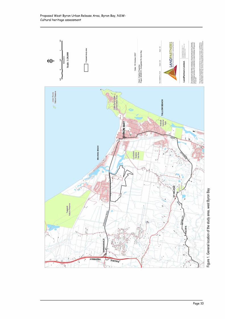
The area addressed in this report encompasses an approximately 108 hectare section of the coastal plain at west Byron Bay, four
kilometres west of Cape Byron and a minimum of 750 metres south of Belongil Beach. It is bounded in the north by Ewingsdale
Road (Main Road 545), in the west by Sunnybrand Chickens, and by Belongil Creek and associated wetlands in the south and east
(Figure 1). The western section of the area is traversed by Melaleuca Drive.
The land parcel comprises the following properties (Figure 2), collectively referred to as the ‘study area’ within this report. The
properties include private land, a drainage reserve (Lot 7020 DP1113431), and a road reserve (Lot 9 DP111821).
• Lots 2 & 3 DP551947
• Lots 5 & 6 DP622736
• Lots 1 & 2 DP878549
• Lot 2 DP818403
• Lots 1 & 2 DP542178
• Lots 227 & 229 DP755695
• Lot 1 DP520063
• Lot 1 DP201626
• Lot 1 DP780242
• Lot 7020 DP1113431
• Lot 9 DP111821
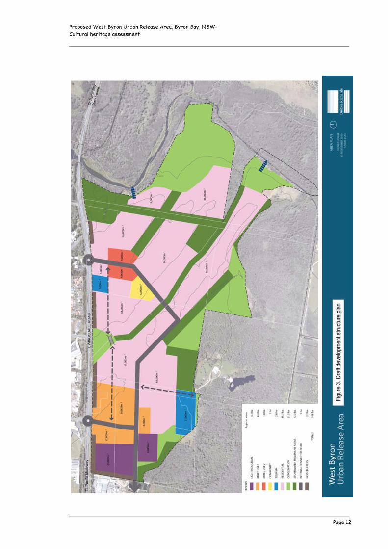
1.3 Potential future development Subject to rezoning, it is anticipated that the study area would be sustainably developed for urban purposes, incorporating general
residential, light industrial and other building allotments, connecting roadways, underground services, and open space stormwater
treatment, public recreation and environmental conservation areas (Figure 3). At this early stage in the approval process the SSS
study will inform the proposed rezoning (Figure 4) and overall preliminary development design, allowing sites/areas requiring further
archaeological investigation to be identified in the development control plan, and allowing areas of special cultural heritage
significance/attachment to be included in open space/conservation areas.
Proposed West Byron Urban Release Area, Byron Bay, NSW- Cultural heritage assessment _____________________________________________________________
_____________________________________________________________ Page 10
!"#$%
&'()'*
&+&%
,-'-./
,0".+
'.1'02
&'30$4
5',%&
,6'7&
30'85
%.+'8
,5

Proposed West Byron Urban Release Area, Byron Bay, NSW- Cultural heritage assessment _____________________________________________________________
_____________________________________________________________ Page 11
1.4 Assessment personnel The field investigation and assessment was conducted by qualified cultural heritage consultant/archaeologist Jacqueline Collins
(MAACAI), assisted and informed by Aboriginal stakeholders/nominated stakeholder representatives Cyril Scott (Tweed Byron Local
Aboriginal Land Council), Yvonne Stewart (Arakwal Elders Aboriginal Corporation), Harry Boyd (Ngaraakbul/Gindavul Elder) and Lois
Cook (Burabi Aboriginal Corporation). Background non-Indigenous historical research and consultation was undertaken by John
Seckold (BA, Dip. Teach) on behalf of the consultant. The report was written by Jacqueline Collins.
!"#$%
&'()'*
+$,-'.
%&.'/
.0,'+
"+/&1
Proposed West Byron Urban Release Area, Byron Bay, NSW- Cultural heritage assessment _____________________________________________________________
_____________________________________________________________ Page 12

Proposed West Byron Urban Release Area, Byron Bay, NSW- Cultural heritage assessment _____________________________________________________________
_____________________________________________________________ Page 13
!"#$
%&'(
)'*%+
,+-&
.'/+
0"0#
Proposed West Byron Urban Release Area, Byron Bay, NSW- Cultural heritage assessment _____________________________________________________________
_____________________________________________________________ Page 14
2 ENVIRONMENT AND LANDUSE EFFECTS
Byron Shire has a warm humid climate with a pronounced summer/autumn wet season, and dry winters. Average annual
temperatures range from a maximum of 23.5 to a minimum of 16.3 degrees Celsius. Soil moisture is adequate for plant growth
throughout the year and growth is only slightly restricted by low winter temperatures (Morand 1994b:5). The Shire lies within the
biogeographic province known as the McPherson-Macleay overlap. This overlap forms a transitional zone between the tropical and
temperate environments, and supports one of the richest and most diverse populations of flora and fauna in Australia (Parsons
Brinckerhoff 2008:25). Despite more than 100 years of historic clearing and landuse, at least twelve potential Aboriginal plant food
species (Bracken Fern, Broom Heath, Swamp Water Fern, Mangrove Fern, Flax Lily, Lance Beard Heath, Saw-sedge, Sweet Smilax,
Blue Lilly Pilly, Midgen Berry, Common Reed, Grey Mangrove) are still represented within the study area (cf LandPartners 2010b:29-
34; Cribb and Cribb 1976; Low 1991).
The study area is situated on the sandy coastal plain within the catchment of Belongil Creek, a small estuarine waterway that flows
northwards just outside the eastern study boundary, draining nearby steep slopes and foothills of a broad basaltic plateau that once
supported the ‘big scrub’ subtropical rainforest (Pugh and Ritchie 1981:10). It is estimated that prior to historic and more recent
artificial drainage, around half the 3,300 hectare Belongil catchment comprised wetlands, including the Belongil-Cumbebin Swamp
wetland complex, which still occupies around 1,000 hectares of land sandwiched between the southern and eastern study
boundaries and the plateau foothills, west of the Byron Bay town centre (NRCMA 2005:5).
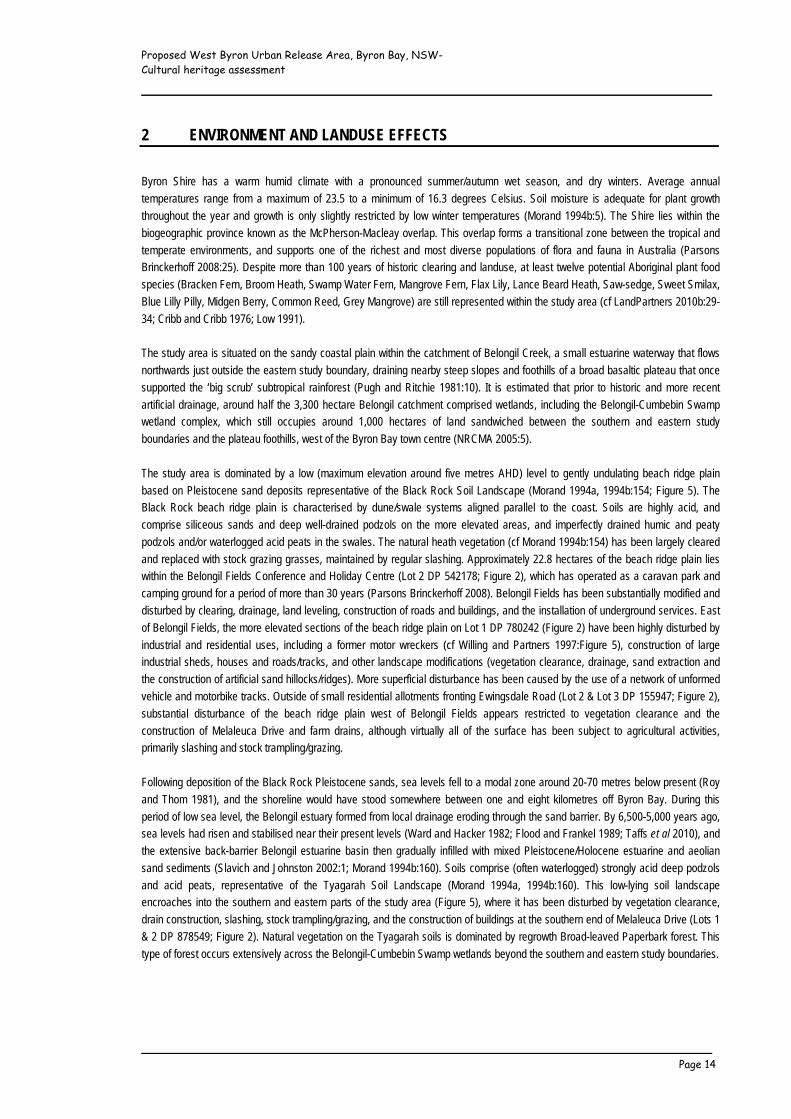
The study area is dominated by a low (maximum elevation around five metres AHD) level to gently undulating beach ridge plain
based on Pleistocene sand deposits representative of the Black Rock Soil Landscape (Morand 1994a, 1994b:154; Figure 5). The
Black Rock beach ridge plain is characterised by dune/swale systems aligned parallel to the coast. Soils are highly acid, and
comprise siliceous sands and deep well-drained podzols on the more elevated areas, and imperfectly drained humic and peaty
podzols and/or waterlogged acid peats in the swales. The natural heath vegetation (cf Morand 1994b:154) has been largely cleared
and replaced with stock grazing grasses, maintained by regular slashing. Approximately 22.8 hectares of the beach ridge plain lies
within the Belongil Fields Conference and Holiday Centre (Lot 2 DP 542178; Figure 2), which has operated as a caravan park and
camping ground for a period of more than 30 years (Parsons Brinckerhoff 2008). Belongil Fields has been substantially modified and
disturbed by clearing, drainage, land leveling, construction of roads and buildings, and the installation of underground services. East
of Belongil Fields, the more elevated sections of the beach ridge plain on Lot 1 DP 780242 (Figure 2) have been highly disturbed by
industrial and residential uses, including a former motor wreckers (cf Willing and Partners 1997:Figure 5), construction of large
industrial sheds, houses and roads/tracks, and other landscape modifications (vegetation clearance, drainage, sand extraction and
the construction of artificial sand hillocks/ridges). More superficial disturbance has been caused by the use of a network of unformed
vehicle and motorbike tracks. Outside of small residential allotments fronting Ewingsdale Road (Lot 2 & Lot 3 DP 155947; Figure 2),
substantial disturbance of the beach ridge plain west of Belongil Fields appears restricted to vegetation clearance and the
construction of Melaleuca Drive and farm drains, although virtually all of the surface has been subject to agricultural activities,
primarily slashing and stock trampling/grazing.
Following deposition of the Black Rock Pleistocene sands, sea levels fell to a modal zone around 20-70 metres below present (Roy
and Thom 1981), and the shoreline would have stood somewhere between one and eight kilometres off Byron Bay. During this
period of low sea level, the Belongil estuary formed from local drainage eroding through the sand barrier. By 6,500-5,000 years ago,
sea levels had risen and stabilised near their present levels (Ward and Hacker 1982; Flood and Frankel 1989; Taffs et al 2010), and
the extensive back-barrier Belongil estuarine basin then gradually infilled with mixed Pleistocene/Holocene estuarine and aeolian
sand sediments (Slavich and Johnston 2002:1; Morand 1994b:160). Soils comprise (often waterlogged) strongly acid deep podzols
and acid peats, representative of the Tyagarah Soil Landscape (Morand 1994a, 1994b:160). This low-lying soil landscape
encroaches into the southern and eastern parts of the study area (Figure 5), where it has been disturbed by vegetation clearance,
drain construction, slashing, stock trampling/grazing, and the construction of buildings at the southern end of Melaleuca Drive (Lots 1
& 2 DP 878549; Figure 2). Natural vegetation on the Tyagarah soils is dominated by regrowth Broad-leaved Paperbark forest. This
type of forest occurs extensively across the Belongil-Cumbebin Swamp wetlands beyond the southern and eastern study boundaries.
Proposed West Byron Urban Release Area, Byron Bay, NSW- Cultural heritage assessment _____________________________________________________________
_____________________________________________________________ Page 15
!"#$
%&'(
)'*+$
,-'.
%&.'
/.0,1
2%3
4'5.1
+&%'6
2%.0
,'78
89.'
.0,'
1"&/,'
2:4&
%;.+
"204<
=&.>
?'%",
#&'@
/."0'
5A/&"
4+2>&
0&'4.
0,<
=&/20
#"/':
.4"0'
/2B/.0
,4'53
"C&,'
A/&"4
+2>&
0&'.
0,'D
2/2>&
0&'4.
0,<

Proposed West Byron Urban Release Area, Byron Bay, NSW- Cultural heritage assessment _____________________________________________________________
_____________________________________________________________ Page 16
Beach ridge plain within southern section of the Belongil Fields Constructed drainage channel (‘Industrial Estate drain’) traversing Conference and Holiday Centre the beach ridge plain within southern section of Belongil Fields
View east across the beach ridge plain south of Belongil Fields, View west across the beach ridge plain south of Belongil Fields showing typical vegetation clearance, slashing, and ground surface exposure
Disturbance of the beach ridge plain east of Belongil Fields, Typical sand exposure resulting from industrial landuses on the within former motor wreckers site beach ridge plain east of Belongil Fields

Proposed West Byron Urban Release Area, Byron Bay, NSW- Cultural heritage assessment _____________________________________________________________
_____________________________________________________________ Page 17
Typical sand exposure on unformed vehicle/motorbike track on View east across the beach ridge plain between Belongil Fields the beach ridge plain east of Belongil Fields and Melaleuca Drive, showing typical vegetation clearance, and landuse disturbance
Constructed drainage channel (‘Industrial Estate drain’) traversing View south across Belongil basin lowlands south of Belongil the beach ridge plain between Belongil Fields and Melaleuca Drive Fields, showing typical vegetation clearance and low surface
exposure
View west across Belongil basin lowlands from eastern study Belongil basin lowlands west of Melaleuca Drive, showing boundary stock trampling exposure

Proposed West Byron Urban Release Area, Byron Bay, NSW- Cultural heritage assessment _____________________________________________________________
_____________________________________________________________ Page 18
3 ABORIGINAL INVOLVEMENT AND CONSULTATION
3.1 Compliance with the Guidelines for Aboriginal Cultural Heritage Impact Assessment and
Community Consultation The Guidelines for Aboriginal Cultural Heritage Assessment and Community Consultation (DEC 2005) prescribe Aboriginal
community consultation requirements in relation to Part 3A approvals under the Environmental Planning and Assessment Act 1979,
and were implemented for this SSS study.
3.1.1 Notification and registration of interests In accordance with the consultation requirements, notifications of the SSS study and the consultant’s intention to prepare this cultural
heritage assessment were mailed to the organisations listed below, inviting the registration of Aboriginal groups and/or individuals
wishing to be involved in the assessment process.
• Tweed Byron Local Aboriginal Land Council
• Arakwal Aboriginal Corporation
• Madhima Gulgan Community Association
• Gold Coast Native Title Group
• Bundjalung Elders Aboriginal Corporation
• Bundjalong Tribal Society
• Jarjum Centre Incorporated
• Cubawee Aboriginal Corporation
• Shared Vision Aboriginal Corporation
• Nunger Aboriginal Corporation
• Nungera Co-operative Society
• Bunjum Co-operative Society
• Tweed Aboriginal Co-operative Society
• Gidabel Aboriginal Corporation
• Numbahging Traditional Owners Group
• Kurracheee Co-operative Society
• Harry Boyd
• Lois Cook (Burabi Aboriginal Corporation)
• Athol Compton
• Canowindra Tweed Byron Aged and Disabled Aboriginal Corporation
• Minyumai Land Holdings Company Ltd
• Minjungbal Culture Museum
• NSW Native Title Services Corporation
• Northern Rivers Catchment Authority
• The General Manager, Byron Shire Council
• Registrar of Aboriginal Owners, NSW Department of Aboriginal Affairs
• Department of Environment, Climate Change and Water
On the 20th of March 2010, a newspaper notice was published in the Northern Star, inviting interested Aboriginal parties to contact
the consultant to formally register their interest in the assessment by the 6th of April 2010.
Responses were received from the following organisations and individuals, who were endorsed as stakeholders in this assessment:
• Tweed Byron Local Aboriginal Land Council (TBLALC)
• Arawkal Aboriginal Corporation
• Harry Boyd (Ngaraakbul/Gindavul Elder)
• Lois Cook
Proposed West Byron Urban Release Area, Byron Bay, NSW- Cultural heritage assessment _____________________________________________________________
_____________________________________________________________ Page 19
• Roy Williams (Ngaraakbul Elder)
• Athol Compton
Athol Compton subsequently withdrew his stakeholder interest in the assessment.
An additional response was received from Matthew Punch, Future Acts Solicitor for the Native Title Services Corporation, requesting
land tenure details (Lot and DP numbers) for the study area for the purposes of assessing Native Title issues. The requested details
(including a land tenure map) were supplied.
3.1.2 Assessment methodology The draft assessment methodology was mailed to the registered Aboriginal stakeholders on the 11th of May 2010, seeking comments
with a view to informing and refining this methodology. No written comments were received. However, verbal endorsement of the
draft methodology was given by the TBLALC, Arakwal Aboriginal Corporation, Harry Boyd and Lois Cook during the course of follow-
up phone contact. Despite numerous calls to his home phone, Roy Williams could not be contacted to provide input to the
assessment methodology.
3.1.3 Drafting, review and report finalisation Draft (hard) copies of this report were posted to the registered Aboriginal stakeholders for review and comment on the 6th of
September 2010. As requested, additional copies of the draft report were provided to the Arakwal Aboriginal Corporation (email, 9th
of November 2010), Harry Boyd (email, 10th of November 2010) and Roy Williams (hard copy, 16th of November 2010).
Correspondence from the TBLALC, Arakwal Aboriginal Corporation and Lois Cook in response to their review of the draft report is
reproduced in Appendix A. Although verbally supporting the Section 10 management recommendations, no written correspondence
has been received from Harry Boyd to date. Any forthcoming correspondence from Harry Boyd will be on-sent to the Department of
Planning once available.
Roy Williams declined to provide a written comment on the draft report, but requested that his given information regarding
grandmother’s (Charlotte Williams nee Brown) traditional attachment to the Byron Bay area be written into the final report (this
request has been accommodated as far as appropriate to the SSS study, which does not purport to investigate or otherwise address
traditional ownership/Native Title issues).
3.2 Native title claims
A search of the National Native Title Register, Register of Native Title Claims, Unregistered Claimant Applications and the Register of
Indigenous Land Use Agreements was performed for the Byron Shire on the 3rd of February 2010. This search revealed that the
study area lies within the boundaries of registered Native Title claim NC01/8 (lodged by the Byron Bay Bundjalung People
[represented by the Arakwal Aboriginal Corporation]), which comprises all claimable lands from the coastline inland to Bangalow,
south from the Brunswick River to the southern boundary of the Byron Shire. The Native Title claim does not include freehold land or
areas where Native Title has been extinguished (by roads, public works or certain leases). As advised by Matthew Punch, Future
Acts Solicitor for the Native Title Services Corporation (email dated 8th April 2010), “following review of the tenure details it appears
unlikely that any formal native title processes under the Native Title Act 1993 (Cth) will be activated by the development.”
3.3 Stakeholder involvement
Detailed pedestrian field survey of the study area was undertaken by the consultant with the assistance of TBLALC sites officer Cyril
Scott and Burabi Aboriginal Corporation stakeholder Lois Cook on the 25th and 26th of May 2010. Albury Scott provided additional
assistance on the 25th of May. The detailed survey was followed-up by reconnaissance inspections with Ngaraakbul/Gindavul Elder
Harry Boyd (27th of May 2010) and Arakwal Aboriginal Corporation CEO Yvonne Stewart (28th of May 2010).
Proposed West Byron Urban Release Area, Byron Bay, NSW- Cultural heritage assessment _____________________________________________________________
_____________________________________________________________ Page 20
The proposed rezoning, Aboriginal cultural heritage issues and values, potential impacts of any future urban development on these
values, and preferred impact mitigation strategies were discussed on-site with Cyril Scott, Lois Cook, Harry Boyd and Yvonne
Stewart.
Due to the failure to reach him by phone, and the lack of response to letters sent with respect to the draft methodology and field and
alternative consultation arrangements, Roy Williams did not participate in the field survey or reconnaissance inspection. Following a
nil response to the mailed draft report, Roy Williams was finally successfully contacted by phone on the 9th of November 2010. As a
result of arrangements made during this phone conversation, the consultant met Roy Williams in Kyogle on the 16th of November
2010. The aims of the SSS study, potential development outcomes and Aboriginal cultural heritage issues (including results and
recommendations of the draft Cultural Heritage Assessment) were discussed. As requested by Roy Williams, a follow-up phone call
was made to his brother Doug Williams on the 17th of November 2010 to further discuss the study area’s cultural heritage values.
3.4 Aboriginal cultural heritage values and issues
Consistent with past information provided by Arakwal Elder (the late) Linda Vidler (Collins 1991:29), the TBLALC, Arakwal Aboriginal
Corporation, Harry Boyd and Lois Cook advised that the study area is not known to contain any sites/places of ceremonial,
mythological or otherwise sacred/spiritual significance. Although a number of unmodified sites/places of on-going socio-cultural value
were/have been reported in and near Byron Bay (cf Collins 1992:42; Collins 1995:49-51; DECCW 2010a:8), including a traditional
songline/dreaming route that passes through the Belongil locality and a source of white ochre (used in body decoration for
ceremonies and fights) on the banks of Belongil Creek, these stakeholders agreed that none of these sites/places would be affected
by any future urban development of the study area.
Roy Williams advised that the whole of Australia constitutes traditional Aboriginal land and is thus of cultural value and attachment,
irrespective of whether or not it contains archaeological sites or remembered sites/places of ceremonial, mythological or otherwise
sacred/spiritual significance. Roy Williams regards the Byron Bay area to have a particularly high level of cultural sensitivity, and
cited the traditional songline/dreaming route in the Belongil locality as a prime example of this sensitivity. As related by Roy’s
grandmother (the late) Charlotte Williams (nee Brown) and published in Robinson (1965, 1989), the songline/dreaming route mirrors
the travels of Nguthungulli, “the father of the whole world”, who came ashore and proceeded inland from “a big rock (that) stands in
the sea six miles out from Byron Bay” (Robinson 1989:88), presumably the ocean outcrop now known as Julian Rocks. Doug
Williams advised that as a result of traditional burial practices and the European massacre of Aboriginal people in the Byron Bay
area, ancestral burials are likely to survive, and may occur within the study area.
The natural environment offered shelter, food and other resources to its traditional inhabitants. Whilst no longer subject to resource
gathering activities, the Belongil-Cumbebin Swamp floodplain forests are known to have been exploited by Aboriginal people in
historical times at least (cf Anon.1954; DECCW 2010a:8), and provide a physical link between the contemporary Aboriginal
community and past generations. As such, the Aboriginal stakeholders regard conservation of the floodplain forests and their
biodiversity integral to maintaining socio-cultural values. Given that the existing floodplain forests would be conserved in the
development-related context (cf Deicke Richards 2010, reproduced as Figure 3 of this report) the TBLALC, Arakwal Aboriginal
Corporation, Lois Cook and Harry Boyd advised that any future development of the study area would not compromise the socio-
cultural values attributed to the natural environment. Considering all factors, including the extent of existing landscape disturbance,
these stakeholders further advised that they have no fundamental objections to future urban development of the study area,
providing the management recommendations presented in Section 10 of this report are implemented (see correspondence, Appendix
A).
Stakeholder Roy Williams elected not to provide a written or formal verbal comment on the adequacy or otherwise of the draft report
or recommendations.

Proposed West Byron Urban Release Area, Byron Bay, NSW- Cultural heritage assessment _____________________________________________________________
_____________________________________________________________ Page 21
4 ABORIGINAL HERITAGE CONTEXT 4.1 Cultural background
According to ethno-historical research conducted in south-east Queensland, the extended family formed the basic socio-economic
unit of traditional Aboriginal life, and several of these would often co-operate as a highly flexible band, gathering and dispersing in
response to social and economic demands. Groups of ‘bands’ then made up loose ‘clans’, which regularly exploited a specific range
or territory (Lilley 1984). Clans were in turn inter-linked by way of a common language (though dialects differed) and reciprocal
marriage arrangements (Calley 1959). In resource-rich coastal areas, clans with at least 100 members occupied reasonably small
territories, the boundaries of which were defined, generally known, and clearly established in mythology (Creamer 1974). Although
there are few early references as to the location and names of the traditional clans, one writer (Anon. 1954) notes that at the time of
first European settlement the Byron Bay people belonged to the Bumberbin ‘tribe’, and numbered 70 by about 1896.
Long-distance travel was undertaken to attend social and ceremonial gatherings, but during the course of everyday life, clan groups
remained within their own well-defined boundaries, moving in tune with the availability of specific resources (eg Ainsworth 1922:17-
18). Local groups seem to have been reasonably sedentary, with “all of them building comfortable huts … capable of holding a
number of persons” (Cunningham 1827:185). Early historical reports suggest the operation of a seasonal landuse system, with
summers spent on the coast fishing and collecting shellfish, and winters spent hunting in the hinterland forests (Ainsworth 1922:17-
18). This seasonal pattern of movement is also evident in myths from the area (eg Robinson 1965:27).
Coastal clans relied heavily on marine resources, particularly fish, with the diet supplemented by a range of terrestrial species,
including flying foxes, pademelons, possums, wallabies, koalas, bandicoots, goannas, carpet snakes, birds, eggs and wood grubs
(Sullivan 1964). During historical times, a large flying fox colony within the Belongil-Cumbebin Swamp contributed substantially to the
diet, such that the local Aboriginal group, “though often shifting camp, seldom went far away on account of this food supply”
(Bundock 1898:4-5; Anon. 1954). Most traditional material items were fashioned from the wood or bark of various trees. These
included shields, spears, boomerangs, clubs, digging sticks, containers, canoes and shelters. A range of stone knives, blades,
scrapers, grinding and chopping tools were also produced (Dawson 1935:202; Flick 1934:6; Piper 1999:21), and examples of these
survive in the archaeological record.
The first known European sighting of the original inhabitants of the Byron Shire was made from the ship HMB Endeavour in 1770,
when James Cook reported a group of about 20 Aborigines on Seven Mile Beach south of Broken Head (Cousins 1933:9). Cedar
cutters arrived on the Richmond in 1842, and by 1845 the coast and lower reaches of both the Richmond and Tweed Rivers had
been virtually taken over by the cedar trade (Rich 1990:120-121). The first selector did not take up land in the Byron district until
1881, but within only two years Byron Bay (Cavvanba) had become a focal point for settlers from the hinterland (Gordon et al 1978).
By around 1896 the Bumberbin people resided in a large camp within the present town area, not far from the site of the former
Council Chambers (200-300 metres inland of the coastline) (Anon. 1954).
Aboriginal people adapted to the European invasion of traditional clan territories by relaxing their strict marriage and visiting rules to
allow for larger-scale shifts in population, resulting in the diffusion of certain elements of the social structure and the re-location of
families and individuals over an increasingly wide area (Calley 1959:115). This widespread pattern of historical movement is
exemplified by Charlotte Williams (nee Brown). According to past Aboriginal consultation (Collins 1995:45-46) and information
provided by Harry Boyd, Roy Williams and Doug Williams during the present assessment, ‘Granny Charlotte’ was raised in the Byron
Bay town area, her mother reportedly born at a traditional birthing site at Suffolk Park (Collins 1995:46). Following her marriage to
Euston Williams at Woodenbong and the birth of at least one child (Millie Boyd) at Stony Gully, Kyogle, Charlotte and family
frequently moved between the coast and Nimbin, living for a time at Middle Pocket, Mullumbimby. Between c.1925-1930, ‘Queen
Charlotte’ (believed to be Charlotte Williams) performed domestic duties at homes between Skinners Shoot and Tyagarah closer to
Byron Bay (cf Collins 1995:45).
In 1882 the NSW Aborigines Protection Board was established, and between this time and 1920, 41 official Aboriginal reserves and
stations were gazetted on the north coast. These included a 10 acre (four hectare) reserve near Tallow Creek, 2.8 kilometres south
Proposed West Byron Urban Release Area, Byron Bay, NSW- Cultural heritage assessment _____________________________________________________________
_____________________________________________________________ Page 22
of Byron Bay, which was gazetted as Aboriginal Reserve No 43074/5 in September 1908, and revoked in March 1916 (McGuigan
1984:20). According to the 1909 Aborigines Protection Board Census there were as few as nine Aboriginal people living on the
Tallow Creek Reserve. These included descendants of those who now identify as the Byron Bay Bundjalung People (represented by
the Arakwal Aboriginal Corporation).
4.2 Registered sites 4.2.1 DECCW Aboriginal Heritage Information Management System
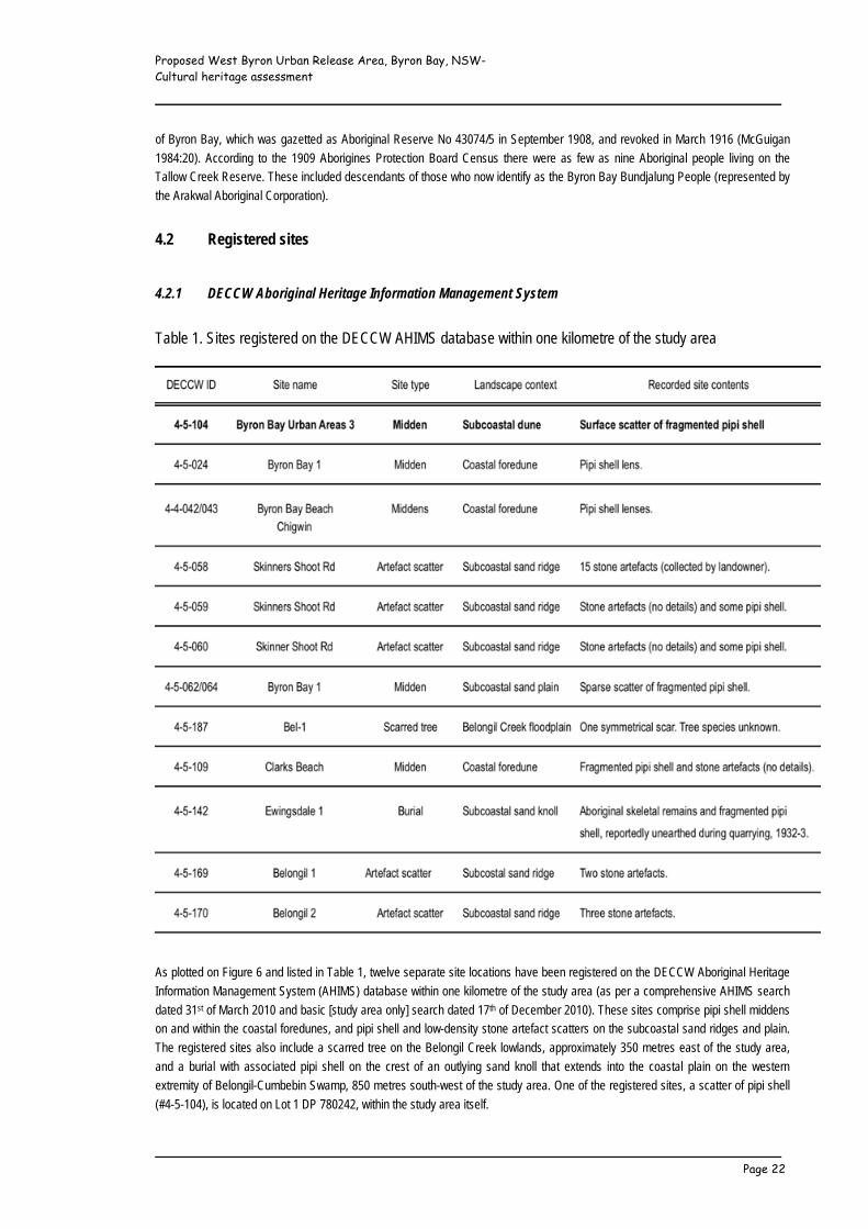
Table 1. Sites registered on the DECCW AHIMS database within one kilometre of the study area
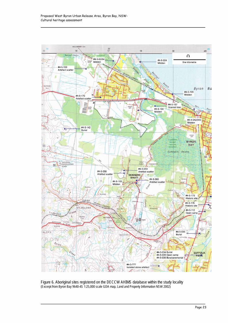
As plotted on Figure 6 and listed in Table 1, twelve separate site locations have been registered on the DECCW Aboriginal Heritage
Information Management System (AHIMS) database within one kilometre of the study area (as per a comprehensive AHIMS search
dated 31st of March 2010 and basic [study area only] search dated 17th of December 2010). These sites comprise pipi shell middens
on and within the coastal foredunes, and pipi shell and low-density stone artefact scatters on the subcoastal sand ridges and plain.
The registered sites also include a scarred tree on the Belongil Creek lowlands, approximately 350 metres east of the study area,
and a burial with associated pipi shell on the crest of an outlying sand knoll that extends into the coastal plain on the western
extremity of Belongil-Cumbebin Swamp, 850 metres south-west of the study area. One of the registered sites, a scatter of pipi shell
(#4-5-104), is located on Lot 1 DP 780242, within the study area itself.
Proposed West Byron Urban Release Area, Byron Bay, NSW- Cultural heritage assessment _____________________________________________________________
_____________________________________________________________ Page 23
Figure 6. Aboriginal sites registered on the DECCW AHIMS database within the study locality (Excerpt from Byron Bay 9640-4S 1:25,000 scale GDA map, Land and Property Information NSW 2002)
Proposed West Byron Urban Release Area, Byron Bay, NSW- Cultural heritage assessment _____________________________________________________________
_____________________________________________________________ Page 24
4.2.2 Other heritage registers Searches of the Commonwealth and National Heritage Lists, Register of the National Estate, the NSW State Heritage Register, and
heritage schedules of the North Coast Regional Environmental Plan 1988 and Byron Shire Local Environmental Plan 1988 (as
amended 2009) revealed no listed Aboriginal heritage sites or places in or near the study area.
4.3 Past archaeological surveys A number of archaeological surveys have been completed in the west Byron locality for planning and development-related purposes.
The most relevant of these are reviewed in this section, and provide an insight to the types, density and environmental contexts of
the identified sites to assist with the construction of a predictive model for the study area.
4.3.1 Within the study area In 1991, Collins conducted a sample field survey of the Byron Shire Urban Investigation Areas. The survey included approximately
30 hectares (27.8 percent) of the present study area, and resulted in the recording of the #4-5-104 pipi shell scatter (cf Figure 6) on
the crest of a low dune (beach ridge plain) approximately 120 metres west of Belongil Creek. The shell was noted to be in a
weathered condition, apparently confined to the sand surface, and was assessed to have limited further research potential.
4.3.2 Outside but near the study area In addition to that within the study area, Collins’ 1991 survey sampled the beach ridge plain and drained lowlands to either side of
Belongil Creek north of Ewingsdale Road, and beach ridges, the beach ridge plain and drained lowlands on the southern margin of
Belongil-Cumbebin Swamp. The survey resulted in the recording of a pipi shell scatter (#4-5-103) on the crest of a beach ridge at
Skinners Shoot, and two isolated stone artefacts (a split volcanic beach pebble and a chert flake) on the lowlands.
Fifteen stone artefacts collected by the landowner from previously registered site #4-5-058, also on the Skinners Shoot beach ridge,
were recorded in detail, revealing a diverse artefact assemblage consistent with use as a base camp. The artefacts included
grindstones, edge-ground axes, scrapers, retouched and unmodified flakes, cores and flaked pieces made on fine-grained volcanic
materials, quartzite, chert and indurated siltstones and mudstones (Collins 1991:45-46).
The first systematic archaeological survey on the Byron Shire coast was undertaken by Starling (1974), targeting areas likely to be
further impacted by mineral sand mining. Although the greater part of the coastline had already been mined, Starling recorded over
four kilometres of discontinuous shell middens, some containing Aboriginal burials, along foredunes north of Cape Byron. Some of
these middens have since been re-recorded and entered onto the DECCW AHIMS register, including sites #4-4-042/043, #4-5-024
and #4-5-109 south of the Belongil Creek mouth (cf Figure 6).
In 1983, Piper inspected a parcel of land north of the North Coast Railway, between Bayshore Drive and Belongil Swamp, at least
300 metres inland of the ocean and 750 metres north of the present study area. This land comprised a Pleistocene beach ridge
flanked by wetlands. No cultural materials were detected within the subject land parcel, nor were any sites of socio-cultural
significance identified by Aboriginal informants consulted by the NSW National Parks and Wildlife Service on Piper’s behalf. One
disturbed pipi shell midden (#4-5-062/064 [double AHIMS entry for the same site]) was recorded near the foot of the sand ridge, 34
metres east of the study boundary.
A 110 hectare area stretching west from Belongil Creek north of the North Coast Railway (a minimum of 500 metres north of the
present study area) that encompassed the #4-5-062/064 midden previously registered by Piper (1983) was investigated by Navin
(1992) in response to a proposed resort development. Navin’s investigation included a field survey directed towards coverage of all
exposed ground exhibiting low landuse disturbance on the beach ridge, back dunes and locally elevated parts of the Belongil basin
lowlands. Archaeological evidence was restricted to the #4-5-062/064 shell scatter, but back dunes in the north-western section of
the area were considered to have moderate potential to contain undetected sites/materials. To more securely assess the
archaeological context of the proposed development area, the field survey was followed-up by a limited program of subsurface
testing on site #4-5-062/064 and the potentially sensitive back dunes (Navin 1992). The site #4-5-062/064 testing involved ground
probing to determine the likely limits of the site, and the excavation of a series of 18 25 x 25 centimetre spade probes and auger

Proposed West Byron Urban Release Area, Byron Bay, NSW- Cultural heritage assessment _____________________________________________________________
_____________________________________________________________ Page 25
holes, spaced between five and 12 metres apart, taken down incrementally into the underlying grey/white culturally sterile sand layer.
The excavated sediments were dry sieved through a 2.5 millimetre mesh screen. The subsurface testing revealed a sparse, spatially
discrete accumulation of weathered pipi shell fragments with a small quantity of fish bone (one fragment only recovered from one of
the test pits), lying between 16 and 32 centimetres below the dune surface. It was concluded that at least the majority of the site had
been subject to varying degrees of post-depositional disturbance and/or surface exposure and weathering, such that it was assessed
to have a low to negligible level of local archaeological significance (Navin 1992:34). No cultural materials were detected or
recovered as a result of ground probing or auger testing across the remainder of the back dune sequence, although it was conceded
that the potential remained for undetected small and discrete or deeply buried archaeological deposits and burials to occur.
In 1994, Stuart conducted an archaeological survey of a 12 hectare section of the Belongil basin lowlands east of Belongil Creek and
south of Ewingsdale Road (immediately east of the present study area) proposed for the construction of sporting fields. Ground
surface visibility was very low, such that Stuart estimated that less than one percent of the area was effectively inspected. The survey
nevertheless resulted in the recording of a tree (species not reported) bearing a symmetrical scar suggestive of Aboriginal bark
extraction. This tree (#4-5-187) lies some 350 metres east of the study area and was assessed to be of medium scientific/
archaeological significance.
More recently, Cotter (2003) surveyed a four hectare area proposed for an upgrade of wetland effluent release associated with the
West Byron Sewage Treatment Plant, situated between Ewingsdale Road and the North Coast Railway (a minimum of 75 metres
north-west of the study area). Cotter’s survey resulted in the recording of scatters of two and three stone artefacts (#4-5-169 and #4-
5-170; chert and mudstone flakes) towards the base of a highly modified sand ridge.
4.4 Archaeological potential of the study area The distribution of registered sites in conjunction with the results of past archaeological surveys in the west Byron locality reflect a
preference for traditional occupation of the coastal foredunes. Elevated landforms on the subcoastal plain, especially beach ridges
(including well-drained basal slopes) and dunes adjacent to Belongil Creek and Belongil-Cumbebin Swamp were also occupied,
generally on a more dispersed and less intensive basis. Evidence for a probable base camp (#4-5-058) on the crest of a beach ridge
that extends from the volcanic escarpment into Belongil-Cumbebin Swamp is nevertheless indicative of at least some more sustained
traditional occupation within the subcoastal zone.
As attested by the report of historical reliance on a flying fox colony (Anon. 1954) and recording of the site #4-5-187 scarred tree,
Belongil-Cumbebin Swamp provided both food and raw material resources. However, even in dry times, it is unlikely that any parts of
the densely forested lowland basin would have been conducive to the establishment of Aboriginal campsites, especially when all
parts of the swamp could have been readily accessed from surrounding higher and better-drained landforms.
4.4.1 Potential site types On the basis of information gained through Aboriginal stakeholder consultation and a review of archaeological sources, the potential
exists for the study area to contain previously unrecorded Aboriginal sites. In tandem with the study area’s environmental and
disturbance context, known site distributions suggest that the following types of sites would be the most likely to occur.
Isolated stone artefacts These can be located anywhere in the landscape and represent either the remnant of a dispersed artefact scatter (open campsite),
or the simple loss or random discard of artefacts. Two isolated artefacts have been recorded on the Belongil-Cumbebin Swamp
lowlands at Skinners Shoot (Collins 1991:42), and are likely to be representative of a low-density background distribution of artefacts
lost or discarded during the course of resource exploitation.
Stone artefact scatters (open campsites) This type of site can range from as few as two stone artefacts to an extensive scatter containing a variety of tools and flaking debris,
sometimes with associated materials such as bone, shell, ochre, charcoal and hearth stones. An artefact scatter does not necessarily
mark a place where actual camping was carried out, but may instead be the product of specialised and/or short-term activities
Proposed West Byron Urban Release Area, Byron Bay, NSW- Cultural heritage assessment _____________________________________________________________
_____________________________________________________________ Page 26
involving some level of stoneworking (eg the manufacture or rejuvenation of a single tool during hunting, or whilst in transit from one
camp to another) (Hiscock 1988:19). Artefact scatters may occur as surface concentrations or as dateable stratified deposits, and
can provide information on such things as patterns of Aboriginal landuse, movement and exchange. With the possible exception of
site #4-5-058 (cf Collins 1991:44-46), artefact scatters in the Byron Bay locality (for which this information has been recorded) contain
a low number and density of stone artefacts.
Shell middens Shell middens are open campsites dominated by shellfish remains. They are usually found close to the shellfish source and contain
predominantly mature specimens of edible species. Middens vary considerably in size. Some are thin surface scatters that have
constituted little more than a meal for a small group gathering food away from a main camp, while others are well consolidated
deposits representing consistent use by large groups of people over long periods of time. In addition to shell, middens may contain
stone artefacts, charcoal from cooking fires, ochre nodules and animal bone. Human burials have also been recorded within midden
deposits, including middens along the foredunes north of Byron Bay (Starling 1974). Test excavations conducted by Collins (1994)
on a coastline pipi midden (#4-5-061) at The Pass, Byron Bay, revealed the deposition of shell, stone flaking debris, ochre, charcoal
and the bones of fish (mainly bream) and other fauna (tortoise, kangaroo/wallaby, bandicoot, possum, rodent, bird and reptile) over a
period spanning between around 1,000 and 400 years ago. This evidence suggests a possible similar antiquity for the pipi shell
middens recorded along foredunes north of The Pass (including site #4-4-042/043, #4-5-024 and #4-5-109 on Belongil Beach), and
site #4-5-104 within the eastern section of the study area.
Scarred trees Aboriginal scarred trees are trees that have been scarred through the deliberate removal of bark or wood for making material items
such as shelters, canoes, shields, boomerangs, containers and rope/twine, or which have been marked for other reasons (eg toe-
holds to aid climbing; the extraction of honey, possums, birds and grubs) (Long 2005). Because scarred trees are usually associated
with domestic activities, their distribution often correlates with the distribution of artefact scatters, middens and other types of
traditional and historic campsites. Given the recording of one scarred tree on the Belongil basin lowlands (#4-5-187; species not
identified/reported), it is anticipated that additional scarred trees could occur at west Byron, dependant upon the survival of trees of a
sufficient age to have been subject to bark and/or wood removal or other marking during the pre- and/or early post-contact period.
Burials While other disposal methods have been reported (eg Richmond River Historical Society 1973), most traditional Aboriginal burials
recorded on the NSW north coast seem to have been primary interments in soft sediments. Graves were sometimes marked by earth
or stone mounds, but the majority of known sites have been found eroding from middens, dunes and creek banks, or have been
unearthed during development activities. Unfortunately, burials can usually only be detected during field survey if they have been
exposed through erosion or if subsurface sediments have been otherwise disturbed. Burials have been reported within foredune
middens north of Cape Byron (Starling 1974, #4-5-037), and in association with pipi shell on the crest of an elevated subcoastal sand
knoll on the western edge of Belongil-Cumbebin Swamp (Collins 1996:15, #4-5-142). Although the presence of burials anywhere on
the beach ridge plain or lowlands at west Byron cannot be discounted, the strongly acid soils (cf Morand 1994a, 1994b) are not
conducive to the preservation of organic materials, such that burials are unlikely to survive unless interred in relatively recent times,
or within a midden deposit of sufficient size/depth to provide localised alkaline soil conditions.
4.4.2 Predictive model of Aboriginal site location Considering the study area’s topography, disturbance history, the likely pattern of Aboriginal landuse and past survey results, it was
predicted that:
• Additional disturbed cultural materials (including disturbed subsurface deposits) may be associated with the
previously registered site #4-5-104 midden scatter on the crest of the low dune on the beach ridge plain near the
eastern study boundary.
• Small low-density surface scatters and/or subsurface deposits comprising stone artefacts and/or midden shell may
occur on or towards the eastern and southern boundaries of the beach ridge plain above the Belongil Creek estuary
and Belongil basin lowlands. There is also some (low) potential for relatively dense artefact occurrences reflective
of base camp uses within this same area. Although not unprecedented (eg Hewitt and Allen 2010), it is anticipated
that at least some evidence of past Aboriginal use, if present, will be detectable on the disturbed/slashed and
exposed sand surface.
Proposed West Byron Urban Release Area, Byron Bay, NSW- Cultural heritage assessment _____________________________________________________________
_____________________________________________________________ Page 27
• Evidence of Aboriginal bark and/or wood removal or other markings may occur on the trunks of any surviving
mature trees.
• Isolated stone artefacts may occur in any topographic or disturbance context.
• Low lying/highly modified sections of the beach ridge plain within and west of Belongil Fields have a low level of
archaeological sensitivity. Archaeological evidence (if any) is likely to be restricted to dispersed isolated stone
artefacts.
• Belongil basin lowlands on the southern and eastern perimeters of the study area have a low level of archaeological
sensitivity. Archaeological evidence (if any) is likely to be restricted to dispersed isolated stone artefacts.
• In the absence of any specific stakeholder knowledge for historic or more recent burials, traditional Aboriginal
burials, if ever present in the study area, are only likely to survive within a substantial midden deposit.
5 NON-INDIGENOUS HERITAGE CONTEXT 5.1 Historic background In the footsteps of cedar cutters who first infiltrated traditional Aboriginal lands during the mid 19th century, the first European land
selectors took up residence at Byron Bay in the early 1880s, after which time the settlement was promoted and developed as the
local hub of sea transportation, and later expanded by way of construction of a railway connecting Lismore and Murwillumbah in
1894 (Stubbs 2006). The selected land was cleared to facilitate the cultivation of crops, including maize, sugar cane, bananas,
pineapples, potatoes and other vegetables. Clearing entailed felling and firing of the ‘scrub or bush’, followed-up by the packing
together and burning of the remaining logs (The Sydney Mail 3/5/1884, cited in Morrison 1969:108). In 1886, Belongil spit west of
Byron Bay and north of the study area was subdivided into 200 allotments available for purchase (Gordon et al 1978:14). Two further
allotments bordering Belongil Creek in the eastern section of the study area were reserved as ‘holding areas for future suburban’
purposes’ (NSW Land and Property Information, Byron Bay Parish Map 1912).
The 1885 opening of the Norco butter factory at Byron Bay (especially after Paspalem grass was introduced in 1891) resulted in an
upsurge of both local dairying and the extraction of timber to supply fuel required to operate the factory. To promote dairying and
other agricultural uses, drainage channels were dug through the lowlands and the recovered sediments used to topdress the
surrounding land (Collins 1990:45). These included channels at west Byron, which were later extended by the Belongil Drainage
Trust (later known as the Belongil Drainage Union), such that by 1913 over six kilometres of major drains (including the Belongil
Union Drain that traverses the south-eastern extremity of the study area) had been constructed, with plans for more work in the
Cumbebin/Skinners Shoot locality (Draper 2002:1; cf Willing and Partners 1997:17). Even though the Cumbebin/Skinners Shoot
drainage scheme did not eventuate, it is estimated that prior to drainage, the Belongil-Cumbebin Swamp wetlands covered an area
some five times larger than at present (Tulau 1999).
The discovery of gold at Shaws Bay, Ballina, precipitated an influx of gold prospectors who took up and operated beach mining
leases between Ballina and Cudgen (including Byron Bay) from 1870 until around 1935, at which time leads had been so exhausted
as to see these followed up to six kilometres inland, and the sale of black sands to Zircon Rutile Co. (Milllership undated; The
Northern Star 8/4/1935). The central and western parts of the study area formed part of the (1887) declared Tweed and Richmond
Rivers Gold Field up to and including 1912 (NSW Land and Property Information, Byron Bay Parish Map 1912). Although not
conclusively demonstrated by the documentary evidence, it is clearly possible that the study area was subject to low-level gold
mining activities during the early decades of the 20th century.
Zircon Rutile Ltd (operating as Z-R Holdings Ltd from 1955) commenced mineral sand mining in the Byron Shire in 1935, and
continued these operations up to 1974 (Stubbs 2006:66). The sand mining involved use of a dredge floating in a purpose-built
artificial pond designed to extract a mixture of sand and water, from which minerals were centrifugally separated. While there is no
record of mineral sand mining within the study area itself, the ‘Industrial Estate drain’ that traverses the area is reported to have
formed part of a more extensive system of drains dug to assist sand mining during the 1950s/1960s (cf Cotter 2003:11).

Proposed West Byron Urban Release Area, Byron Bay, NSW- Cultural heritage assessment _____________________________________________________________
_____________________________________________________________ Page 28
Between 1954 and 1962, Byron Bay operated as a whaling station (Ryan 1984:133-140; Stubbs 2006:57-59). During this time, some
1,148 whales (primarily humpbacks) were processed through the whaling factory, located on the Belongil Beach dunes
approximately 500 metres north-east of the study area. Consultation undertaken by Cotter (2003:12) with local landowner George
Flick and former whale factory employee Colin Smith revealed that whale heads, and jawbones in particular, were buried north of
Ewingsdale Road. For the entire eight years of factory operation, the baleen was disposed of within this same place and adjacent
areas. The baleen is said to have been deposited on a daily basis into pits around 20 metres long, three metres wide and three
metres deep, aligned along the sand ridge north-west of the study area (Cotter 20093:13). Neither of Cotter’s informants indicated
that any whale remains were buried south of Ewingsdale Road.
5.2 Registered sites
Searches of the Commonwealth and National Heritage Lists, Register of the National Estate, the National Trust of Australia (NSW)
Register, the NSW State Heritage Register, and heritage schedules of the North Coast Regional Environmental Plan 1988 and Byron
Shire Local Environmental Plan 1988 (as amended 2009) revealed no listed historic cultural heritage sites or places in the study
area.
5.3 Other heritage records and information
The Brunswick Valley Historical Society holds a collection of primary and secondary source material relating to the non-Indigenous
settlement of the Byron Shire. In conjunction with an examination of this material, oral information was kindly provided by local
resident John Borrowdale, who lived in close proximity to the study area in the late 1950s and 1960s.
John Borrowdale advised that during the late 1950s and 1960s the study area primarily consisted of unused swamp. At this time,
landuses were restricted to minor cattle grazing, the focus of cattle grazing being east of Belongil Creek. Mr Borrowdale reported no
knowledge of any sites/places of possible historic significance within the study area. This advice is consistent with records held by
the Brunswick Valley Historical Society.
5.4 Past heritage assessments Archaeological survey of the Belongil basin lowlands proposed for construction of sporting fields east of Belongil Creek and
immediately east of the present study area revealed no historic heritage sites (Stuart 1994).
During an assessment of the area proposed for an upgrade of wetland effluent release associated with the West Byron Sewage
Treatment Plant, located between Ewingsdale Road and the North Coast Railway (a minimum of 75 metres north-west of the study
area), Cotter (2003) identified the possible deposition of the baleen from more than 1,000 whales and jaw segments (‘knuckle
bones’) from perhaps 200 whales processed through the Byron Bay whaling factory between 1954 and 1962. Because baleen is
regarded as the best medium for the preservation of whale DNA, Cotter considered the baleen buried within her study area to
potentially represent an invaluable scientific resource for comparative DNA studies with the modern Humpback Whale population.
Cotter (2003:32) concluded that the whale remains, if surviving in situ within the sand ridge and swamp would be of considerable
cultural (historic and scientific) significance, representative of a unique form of archaeological deposit in the Australian context. The
investigation revealed no evidence for the deposition of whale remains in the present study area.
More recently, a comprehensive assessment of sites and places of non-Indigenous cultural heritage significance has been
undertaken in conjunction with preparation of the Byron Shire Community-Based Heritage Study. This study included a thematic
history (Stubbs 2006), along with extensive community consultation to identify, record and assess heritage significance within the
Shire (Ellsmore 2007). The thematic history (Stubbs 2006) identified the following main themes that have influenced non-Indigenous
development of the Byron Shire and its present identity:
Proposed West Byron Urban Release Area, Byron Bay, NSW- Cultural heritage assessment _____________________________________________________________
_____________________________________________________________ Page 29
• Discovery and exploration.
• Transportation and communication.
• Forest industry and forest conservation.
• Agriculture, dairying and related industry.
• Fishing and whaling.
• Quarrying, mining and mineral processing.
• Towns and villages.
• Leisure and tourism.
The Community-Based Heritage Study resulted in the production of a detailed inventory of over 400 items of potential local heritage
significance. Of these, 200 individual items, five conservation areas, and eight serial listings, were recommended for inclusion on the
Byron Shire LEP heritage schedule. The remaining items were recommended for recording only, pending further research or new
information that would establish local significance values. None of the items recommended for LEP listing or further research are
located in the study area.
5.5 Potential heritage items in the study area
Background research indicates that the study area was never substantially developed in terms of the built environment. Rather, non-
Indigenous uses centred on agricultural activities that most likely commenced in the last quarter of the 19th century, but were not well
established until the early 20th century. In view of these landuses and the extent of modern land modification, it was anticipated that
any surviving items of non-Indigenous cultural heritage value would be limited to:
• Items and features associated with the theme ‘Agriculture, dairying and related industry’. These may include old
post and rail fences, farm dwellings, outbuildings and dairies, historic drainage channels, tree plantings, and
movable domestic and rural artefacts.
6 FIELD SURVEY 6.1 Method and procedure
Field survey of the study area was conducted by the consultant with the assistance of Lois Cook and Tweed Byron LALC sites officer
Cyril Scott on the 25th and 26th of May 2010. Albury Scott provided additional assistance on the 25th of May. Unforeseen
circumstances prevented Arakwal Elders CEO Yvonne Stewart attending on either day, as previously arranged. The detailed survey
was followed-up by a general field reconnaissance with Harry Boyd and Yvonne Stewart on the 27th and 28th of May 2010
respectively. Weather conditions were fine and sunny on all days, and were conducive to the detection of surface archaeological
materials.
Due to the distribution and types of archaeological sites expected to survive within the study area (cf Section 4.4), blanket survey
coverage was not considered warranted. Instead, a selective survey strategy was adopted to ensure full coverage of all available
surface exposures on largely unmodified elevated sections of the beach ridge plain. The Belongil basin lowlands and substantially
modified and lower, poorly drained sections of the beach ridge plain were sampled. A general wide-area reconnaissance was
additionally undertaken to locate and inspect any mature trees for signs of Aboriginal marking/scarring. The detailed survey was
conducted on foot by the team members walking in parallel transects up to a maximum of 20 metres apart, inspecting all exposed
ground between. Repeated traverses were made across the low dune containing the #4-5-104 pipi shell scatter for the purposes of
detecting and recording any further site information. Survey for potentially significant non-Indigenous sites/items was conducted
concurrently with the Aboriginal field survey, supplemented by a further field inspection on the 29th of May 2010.

Proposed West Byron Urban Release Area, Byron Bay, NSW- Cultural heritage assessment _____________________________________________________________
_____________________________________________________________ Page 30
6.2 Coverage Table 2. Environmental context of survey units
For reporting purposes, the study area was divided into eight separate survey units (SUs), defined on the basis of landform,
disturbance, exposure and visibility. The extent of the present and past surface inspections (Collins 1991) undertaken across each of
the SUs is mapped on Figure 7, and their landform/disturbance context summarised in Table 2.
In all, approximately 62 hectares (57.4 percent) of the study area was covered during the field survey. To provide data suitable for
evaluating survey effectiveness, variables constraining archaeological visibility were estimated for each of the survey units. These
include an estimation of the mean frequency with which surface exposures were encountered, as well as an estimation of the quality
of visibility on those exposures (mean frequency of bare ground suitable for artefact detection). Once the variables of exposure and
visibility are taken into account, it is estimated that 14.7 percent of the surveyed land was subject to effective survey coverage (Table
3), including 12.4 percent of the total beach ridge plain and 1.6 percent of the total Belongil basin lowlands represented within the
study area. Given the study area’s topography and disturbance history, the amount of ground covered on foot, and the environmental
context of land that provided useable exposures, the effective survey sample is considered to have been satisfactory for the
purposes of assessing the nature and extent of the archaeological resource.
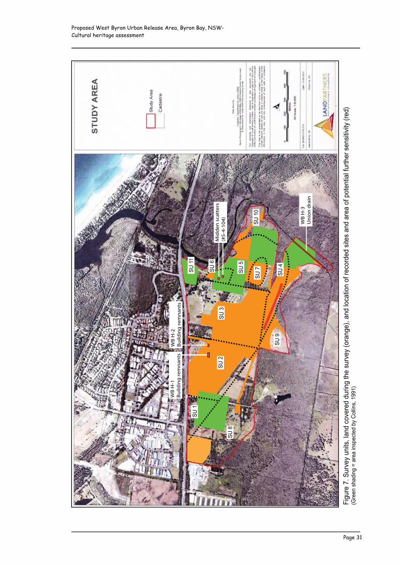
Proposed West Byron Urban Release Area, Byron Bay, NSW- Cultural heritage assessment _____________________________________________________________
_____________________________________________________________ Page 31
!"#$
%&'(
)'*$%
+&,'
$-"./
0'12-
3'45
+&%&
3'3$
%"-#'
.6&'
/$%+
&,'75
%2-#
&80'2
-3'15
42."5
-'59
'%&45
%3&3
'/".&
/'2-
3'2%
&2'5
9':5.
&-."2
1'9$%
.6&%
'/&-
/"."+"
.,'7%
&38'
7;%&
&-'/
623"
-#'<
'2%&
2'"-
/:&4
.&3'
=,'>
511"-
/0'?
@@?8
*A'B
*A'C
*A'(
*A'D
*A'@
*A'?
E
WB
H-2
Build
ing
rem
nant
sW
B H
-1Bu
ildin
g re
mna
nts
WB
H-3
Uni
on d
rain
Mid
den
scat
ters
(#5-
4-10
4)
*A'?
*A'F
*A'G
*A'H
*A'?
?
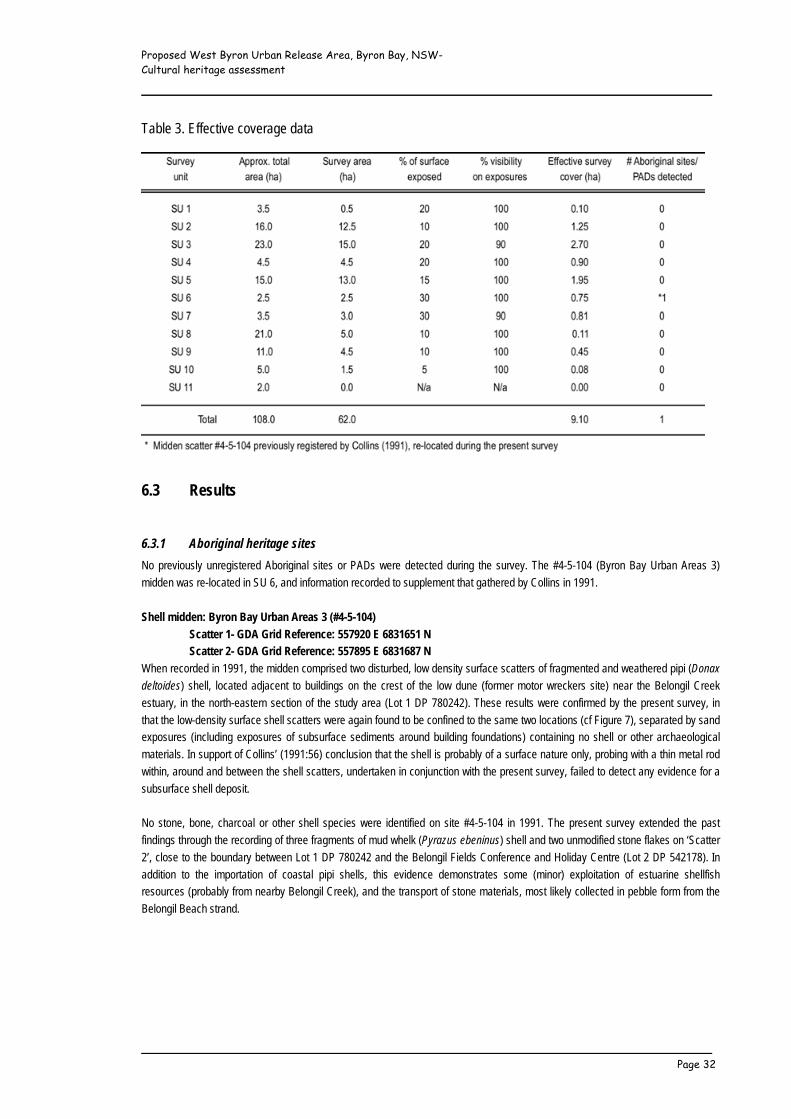
Proposed West Byron Urban Release Area, Byron Bay, NSW- Cultural heritage assessment _____________________________________________________________
_____________________________________________________________ Page 32
Table 3. Effective coverage data
6.3 Results 6.3.1 Aboriginal heritage sites No previously unregistered Aboriginal sites or PADs were detected during the survey. The #4-5-104 (Byron Bay Urban Areas 3)
midden was re-located in SU 6, and information recorded to supplement that gathered by Collins in 1991.
Shell midden: Byron Bay Urban Areas 3 (#4-5-104) Scatter 1- GDA Grid Reference: 557920 E 6831651 N Scatter 2- GDA Grid Reference: 557895 E 6831687 N
When recorded in 1991, the midden comprised two disturbed, low density surface scatters of fragmented and weathered pipi (Donax deltoides) shell, located adjacent to buildings on the crest of the low dune (former motor wreckers site) near the Belongil Creek
estuary, in the north-eastern section of the study area (Lot 1 DP 780242). These results were confirmed by the present survey, in
that the low-density surface shell scatters were again found to be confined to the same two locations (cf Figure 7), separated by sand
exposures (including exposures of subsurface sediments around building foundations) containing no shell or other archaeological
materials. In support of Collins’ (1991:56) conclusion that the shell is probably of a surface nature only, probing with a thin metal rod
within, around and between the shell scatters, undertaken in conjunction with the present survey, failed to detect any evidence for a
subsurface shell deposit.
No stone, bone, charcoal or other shell species were identified on site #4-5-104 in 1991. The present survey extended the past
findings through the recording of three fragments of mud whelk (Pyrazus ebeninus) shell and two unmodified stone flakes on ‘Scatter
2’, close to the boundary between Lot 1 DP 780242 and the Belongil Fields Conference and Holiday Centre (Lot 2 DP 542178). In
addition to the importation of coastal pipi shells, this evidence demonstrates some (minor) exploitation of estuarine shellfish
resources (probably from nearby Belongil Creek), and the transport of stone materials, most likely collected in pebble form from the
Belongil Beach strand.

Proposed West Byron Urban Release Area, Byron Bay, NSW- Cultural heritage assessment _____________________________________________________________
_____________________________________________________________ Page 33
View north across dune crest towards site #4-5-104 midden. ‘Scatter 1’ Site #4-5-104 midden, ‘Scatter 1’ is located in front of building
Stone artefact details:
1) Greywacke flake, 38 x 72 x 12 millimetres
No platform, plunge termination, 1 dorsal negative scar
80 percent dorsal pebble cortex.
2) White chert flake, 53 x 30 x 8 millimetres
Focal flaked platform with platform preparation scars, hinge termination, 4 dorsal negative scars
20 percent dorsal pebble cortex.
6.3.2 Non-Indigenous heritage sites Three sites/items of potential non-Indigenous (historic) heritage value were recorded during the field survey. These include building
remnants (designated WB H-1 and H-2) and a drainage channel (WB H-3). Locations of these sites/items are plotted on Figure 7.
WB H-1: Building remnants GDA Grid Reference: 557360 E 6831796 N
View east across WB H-1, showing grassed area (brown) inside the WB H-1. Standing rainwater tank on wooden posts and more building foundations recent brick piers
This site is located in the central eastern section of Lot 1 DP 542178, and comprises the remnants of a demolished building, probably
once used as a horse stable or pig pen. The surviving material evidence includes concrete foundations around the perimeter of a 46
by 9.2 metre enclosure (filled inside with introduced earth and gravel, now grassed), topped with up to three courses of dry-pressed,

Proposed West Byron Urban Release Area, Byron Bay, NSW- Cultural heritage assessment _____________________________________________________________
_____________________________________________________________ Page 34
kiln-fired bricks; and an adjacent quartz gravel and concrete water trough (formed up with corrugated iron both inside and out), and
two corrugated iron rain-water tanks, one of which still rests on a dilapidated wooden post frame, shored up by more recently
constructed brick piers.
WB H-2: Building remnants GDA Grid Reference: 557416 E 6831791 N
This site is located approximately 50 metres east of WB H-1, also in the eastern section of Lot 1 DP 542178, and is believed to
represent the vestiges of a pig pen, probably constructed during the mid-1900s. The site comprises remnant concrete masonry
(Besser Block) wall sections up to a height of 1.2 metres (with evidence for a former wire mesh front and concrete apron outside),
surrounding a 20 by five metre concrete slab floor; an associated concrete feeding trough, and piles of demolished building refuse.
View east across WB H-2, showing Besser Block wall WB H-2. Demolished building refuse
WB H-3: Belongil Union Drain
GDA Grid Reference (centre, within study area): 558100 E 6831050 N The Belongil Union Drain runs through Belongil/Cumbebin Swamp, and traverses the south-eastern extremity of the study area
before continuing north (outside the study boundary) to empty into the Belongil Creek estuary. The drain is up to five metres wide,
and is tidal to at least the area south of Melaleuca Drive (Water and Carbon Group 2010:12).
Despite some initial objection to construction of this drain (The Byron Bay Record, 5/11/1910), a newspaper advertisement published
in the Byron Bay Record on the 8th of July 1911 sought labourers for the drainage works, at a pay rate of eight shillings per day.
Under the auspices of NSW Government incentives aimed at promoting agricultural expansion, the Union Drain was constructed in
1913, following official establishment of the Belongil Drainage Union under the Water Act 1912, to facilitate agricultural development
of the lowlying land.
Evidence indicates that regular maintenance using modern excavators has resulted in the deepening and widening of many of the original hand-dug drainage channels (NRCMA 2005:17), including the Belongil Union Drain (cf Draper 2002; Water and Carbon Group 2010:12). Within the study area, the excavated drain spoil has been successively dumped along the western margin of the drain, creating a low, generally exposed artificial levee traversed by a vehicle/machine track.
Along with several other primary drains (including the ‘Industrial
Estate drain’, initially dug by sand miners but augmented during
more recent development of the west Byron industrial estate), the

Proposed West Byron Urban Release Area, Byron Bay, NSW- Cultural heritage assessment _____________________________________________________________
_____________________________________________________________ Page 35
Union Drain is still administered by the Belongil Drainage Union for the purposes of mitigating the effects of floods and tides (Tulau
1999; LandPartners 2010a:12).
7 STATUTORY CONTEXT 7.1 Aboriginal heritage- NSW National Parks and Wildlife Act 1974 The NSW National Parks and Wildlife Act 1974 (as amended by the National Parks and Wildlife Amendment Act 2010) provides the
primary basis for the statutory protection and management of Aboriginal sites in NSW and the administration of legislation pertaining
to sites is currently the responsibility of the Department of Environment, Climate Change and Water (DECCW). The provisions of the Act apply to all Aboriginal objects, regardless of whether or not they have been registered with the DECCW, or whether they occur
on private or public land. Except where destruction of an Aboriginal object is or will be demonstrably unavoidable, it is DECCW policy
to require conservation in its original location and context.
The National Parks and Wildlife Act 1974 defines a protected ‘Aboriginal object’ as-
‘any deposit, object or material evidence (that is not a handicraft made for sale) relating to Aboriginal habitation of NSW,
before or during the occupation of that area by persons of non-Aboriginal extraction (and includes Aboriginal remains).’
The National Parks and Wildlife Amendment Act 2010, which came into full force on the 1st of October 2010, made significant
changes to the provisions of the National Parks and Wildlife Act 1974, under which a person could only be prosecuted if Aboriginal
objects or places were ‘knowingly’ harmed. A new ‘strict liability’ offence has now been added (Sections 86[1] and 86[4] of the
National Parks and Wildlife Amendment Act 2010) to include instances where impacts have not been authorised by the DECCW and
carried out in line with the conditions of a duly approved Aboriginal Heritage Impact Permit (AHIP), and Aboriginal sites and/or places
are accidentally or otherwise unknowingly harmed. It is a defence to prosecution under the Act if:
• The defendant can demonstrate that they exercised due diligence to reasonably determine that no Aboriginal
objects would be harmed (cf ‘Due Diligence Code of Practice for the Protection of Aboriginal Objects in NSW’,
DECCW 2010c), or
• Any disturbance is prescribed by the National Parks and Wildlife Amendment [Aboriginal Objects and Aboriginal Places] Regulation 2010 as a low impact act or omission.
Under the National Parks and Wildlife Amendment [Aboriginal Objects and Aboriginal Places] Regulation 2010, small-scale
archaeological test excavations are held to be a low impact act, and do not require an AHIP, providing the test excavations and
reporting are consistent with the ‘Code of Practice for Archaeological Investigation of Aboriginal Objects in NSW’ (DECCW 2010d).
As listed in the subject Code of Practice (DECCW 2010d:24), “test excavation which is not excluded from the definition of harm” (and
thus requires an AHIP) includes any subsurface investigation within 50 metres of a shell midden.
7.2 Non-Indigenous heritage- NSW Heritage Act 1977 The NSW Heritage Act 1977 (as amended) is designed to conserve the environmental heritage of the State. Environmental heritage
is broadly defined under Section 4 of the Act as comprising-
‘those places, buildings, works, relics, moveable objects, and precincts, of State or local heritage significance.’
A ‘relic’ is defined under Section 4(1) as ‘any deposit, artefact, object or material evidence’ that:
(a) Relates to the settlement of the area that comprises New South Wales, not being Aboriginal settlement; and
(b) Is of State or local heritage significance.
An appropriate approval/permit must be obtained from the Heritage Council for works that have the potential to interfere with a
heritage item or place which is either listed on the State Heritage Register or subject of an interim heritage order (Section 57); and to
authorise the disturbance/excavation of land where it is known (or there is reasonable cause to suspect) that such action will or is
likely to uncover or affect a relic (Section 139). Certain activities are exempted from the Section 57 approval requirements, including
Proposed West Byron Urban Release Area, Byron Bay, NSW- Cultural heritage assessment _____________________________________________________________
_____________________________________________________________ Page 36
some forms of maintenance, repair, and minor excavations. A series of exceptions have also been established with respect to
Section 139 approvals. Excavation or disturbance of the following land does not require an excavation permit under the Heritage Act, providing the Director (Heritage Branch, DoP) is satisfied that criteria (a), (b) or (c) have been met:
(a) Where an archaeological assessment has been prepared in accordance with Guidelines published by the Heritage
Council, indicating that there is little likelihood of there being relics in the land, or that any relics in the land are
unlikely to be of State or local heritage significance;
(b) Where excavation or disturbance of the land will have a minor impact on the archaeological resource; and
(c) Where excavation or disturbance of the land involves only the removal of fill, which has been deposited on the land.
To obtain an exemption from the Section 139 permit requirement under the above criteria, the person wishing to excavate or disturb
the land must write to the Director, describing the proposed excavation/disturbance and setting out how/why these activities satisfy
the exemption criteria. The Director will then notify the applicant if he/she is satisfied that a permit exemption is warranted.
7.3 NSW Environmental Planning and Assessment Act 1979 In essence, the Environmental Planning and Assessment Act 1979 (EP&A Act) (including associated schedules, regulations and
guidelines) requires that environmental impacts be considered in landuse planning and decision-making. As listed under Section 90
of the Act, environmental impacts that must be considered before any development can be approved include cultural heritage
resources and values.
Regional and Local Environmental Plans prepared under the auspices of the EP&A Act contain heritage schedules that identify and
list sites/places of acknowledged cultural heritage significance, and define statutory requirements with respect to the potential
development, modification and conservation of these sites/places, including requirements for conservation/protection or further
assessment of the listed sites/places, and assessment of potentially sensitive lands ahead of development approval.
The development consent authority under a Local Environmental Plan is usually the local Shire or City Council (eg Byron Shire
Council). In determining a development application (DA), DoP best practice guidelines include an assessment of how the proposed
development will affect the subject property (or adjacent properties), in terms of its historic, scientific, cultural, spiritual, archaeological
and natural heritage values.
In late 2005, the NSW Government amended the EP&A Act by introducing a new Part 3A to streamline and integrate the assessment
and approvals process for major projects. Under Part 3A (Section 75U), authorisations for an approved project, including Aboriginal
Heritage Impact Permits under Part 6 of the National Parks and Wildlife Act 1974 and Heritage Impact/Excavation Permits under Part
6, Part 4 and Section 139 of the Heritage Act 1977 are not required for development-related works that may impact upon cultural
heritage. However, the Department of Planning (DoP) takes account of heritage issues and consults with the DECCW and the NSW
Heritage Council to ensure that any such issues are duly considered prior to granting project approval.
7.4 The study area
The study area is currently regarded to be a potential State Significant Site (SSS). This assessment forms part of a comprehensive
study directed towards meeting the DoP requirements (issued on the 3rd of November 2009) for designation as a SSS. If accepted as
a SSS, the proposed rezoning/development within the study area may be assessed under Part 3A of the EP&A Act. Otherwise, the
legislative conditions imposed by the National Parks and Wildlife Act 1974 (as amended by the National Parks and Wildlife Amendment Act 2010) and the Heritage Act 1977 would apply.

Proposed West Byron Urban Release Area, Byron Bay, NSW- Cultural heritage assessment _____________________________________________________________
_____________________________________________________________ Page 37
8 SIGNIFICANCE ASSESSMENT Unlike aspects of the natural environment, cultural heritage sites and places are social constructs that have no intrinsic significance-
“cultural heritage places are not alive in themselves, people give them ‘life’ and meaning by the way they treat them and by the way
they think and feel about them. … their value lies entirely within human culture” (Byrne et al 2001:22-23). The degree and type of
value of a place will be different for various groups and individuals. All places are not equally significant or important, and
consequently are not equally worthy of conservation and management (Pearson and Sullivan 1999:17). Assessments of significance
thus form the basis for management decisions and guide the development of impact mitigation strategies where these are warranted.
8.1 Aboriginal cultural heritage
Aboriginal sites and places may have educational, tourism and other public values, but their primary values are generally those
relating to their social/cultural significance to Aboriginal people, and scientific significance from an archaeological/scientific
perspective. While sites considered to be archaeologically significant are usually also significant to the Aboriginal community, others
may be of outstanding Aboriginal cultural/social significance but have little or no archaeological/scientific value.
8.1.1 Aboriginal social/cultural significance This type of significance relates to the cultural values held by and manifest within the contemporary Aboriginal community. Aboriginal
cultural heritage is by no means confined to physical (archaeological) evidence. The cultural landscape contains an invisible overlay
of attachments and meanings, and Aboriginal people can and do hold equally strong and equally legitimate attachments to natural,
unmodified, features of the landscape, and to entire landscapes themselves. The preservation of sites and places of social/cultural
significance can be fundamental to maintaining an Aboriginal community's integrity, sense of place and unique cultural identity.
The level of significance that an individual site or place may hold for the Aboriginal community is often dependent upon a variety of
factors, including the nature, type and integrity of the site/place, the spiritual, emotional, historical and/or contemporary attachments
attributed to it, its setting and importance within the traditional and/or current landscape, and the perceived value of the site/place in
connecting past, present and future generations.
8.1.2 Scientific/archaeological significance Scientific/archaeological significance is essentially an assessment of a site's potential to add to our understanding of past human
behaviour. Such assessment is made not only with regard to currently available knowledge, theories and data retrieval methods, but
with consideration of likely future scientific developments. Sites have particular potential, and thus greater scientific significance, if
there are few other sites that can contribute similar types of information, if they are in a good state of preservation, if they can provide
a chronology extending back into the past, and/or if they form part of a larger site complex (NPWS 1997:26-28).
From a management and research perspective it is desirable that a representative sample of Aboriginal sites be maintained for the
future. This means that not only are rare and unusual types of sites scientifically significant, but that a well-preserved archaeological
site that provides a characteristic example of other sites common to its specific type, content and setting may also be of scientific
significance. Any determination of representativeness must, by necessity, be based on the known sites in a region. Clearly, this will
depend on the extent to which a region has been surveyed and as more work is completed and additional sites recorded, site
representation (and significance) can change.
8.1.3 Shell midden: Byron Bay Urban Areas 3 (#4-5-104) The evidence at hand suggests that the midden is highly disturbed, largely (if not entirely) confined to the surface, contains a low
density and diversity of cultural materials, and is unlikely to offer research information above that presented in Section 6.3.1 of this
report. While the midden is provisionally assessed to be of low socio-cultural (as per advice from the TBLALC, Arakwal Aboriginal
Corporation, Harry Boyd and Lois Cook) and scientific/archaeological significance, archaeological testing directed towards
establishing the presence/absence of subsurface deposits would be necessary to provide information for a more definitive
significance assessment of this site.
Proposed West Byron Urban Release Area, Byron Bay, NSW- Cultural heritage assessment _____________________________________________________________
_____________________________________________________________ Page 38
8.1.4 Balance of the study area The study area sits within a wider environment that contains traditional ceremonial and mythological sites/places, and both traditional
and more recent camping/residential, resource-use and burial places. Together, these form part of a cultural landscape of high and
enduring socio-cultural significance.
However, TBLALC and Arakwal Aboriginal Corporation representatives, and stakeholders Harry Boyd and Lois Cook advised that the
study area itself is not known to contain any sites/places of traditional ceremonial or otherwise spiritual significance, or any
sites/places or resources of special contemporary attachment. Providing the Section 10 management recommendations are
implemented (including any impact mitigation measures arising from the recommended further archaeological investigations) it is
considered that Aboriginal sites and values would be unlikely to be adversely affected by future urban development of the study area.
8.2 Non-Indigenous cultural heritage
8.2.1 Assessment criteria The NSW Heritage Office (2001; now Heritage Branch, DoP) has outlined a set of criteria and a methodology for assessing the
significance of individual elements of a place/item. The NSW guidelines follow the nationally recognised Australia ICOMOS Charter
for the Conservation of Places of Significance (The Burra Charter), which defines ‘cultural significance’ as meaning:
‘aesthetic, historic, scientific and social value for past, present and future generations.’
To simplify the assessment process, the use of only two levels of significance (State and local) is advocated. An item is considered to
be of State (or local) significance if, in the opinion of the Heritage Branch, DoP, it meets one or more of the following criteria (NSW
Heritage Office 2001:9):
Criterion (a) An item is important in the course, or pattern, of NSW’s cultural or natural history (or the cultural or natural
history of the local area);
Criterion (b) An item has strong or special association with the life or works of a person, or group of persons, of importance
in NSW’s cultural or natural history (or the cultural or natural history of the local area);
Criterion (c) An item is important in demonstrating aesthetic characteristics and/or a high degree of creative or technical
achievement in NSW (or the local area);
Criterion (d) An item has strong or special association with a particular community or cultural group in NSW (or the local
area) for social, cultural or spiritual reasons;
Criterion (e) An item has the potential to yield information that will contribute to an understanding of NSW’s cultural or
natural history (or the cultural or natural history of the local area);
Criterion (f) An item possesses uncommon, rare or endangered aspects of NSW’s cultural or natural history (or the cultural
or natural history of the local area);
Criterion (g) An item is important in demonstrating the principal characteristics of a class of NSW’s (or the local area’s)
cultural and natural places, or, cultural and natural environments.
In using these criteria, the value of a place or item (cf Table 4) is first assessed, then the context (State or local) in which it is
significant. Different components of a place may make a different contribution to its heritage value. Loss of integrity or condition, for
instance, may diminish significance.
8.2.2 WB H-1 and WB H-2: Building remnants The WB H-1 and WB H-2 building remnants are believed to represent the material vestiges of demolished animal compounds/pens,
probably dating to the mid-20th century, and relate to the local historical theme of ‘agriculture, dairying and related industry’ (Stubbs
2006). The building remnants are not assessed to be of either State or local heritage significance under any of the assessment
criteria advocated by Heritage Branch (Heritage Office 2001), nor are they likely to be of any localised heritage or interpretive value.
8.2.3 WB H-3: Belongil Union Drain The Belongil Union Drain was dug by hand in 1913, but has been deepened and widened by machinery over the years up to recent
times. The drain relates to the local historical theme ‘agriculture, dairying and related industry’ (Stubbs 2006). Although having some
local historical value under criterion (g), modern modifications detract from its historical significance such that the short section of the

Proposed West Byron Urban Release Area, Byron Bay, NSW- Cultural heritage assessment _____________________________________________________________
_____________________________________________________________ Page 39
drain encompassed within the south-eastern section of the study area is not assessed to be of sufficient significance to warrant
either local or State heritage listing under any of the criteria advocated by Heritage Branch (Heritage Office 2001).
Table 4. Gradings of significance advocated by Heritage Branch, NSW Department of Planning
9 POTENTIAL DEVELOPMENT IMPACTS AND MITIGATION STRATEGIES As outlined in Section 1.1, this assessment forms part of a SSS study, which may result in listing of the subject land in Schedule 3 of
State Environmental Planning Policy (Major Development) 2005. Such listing would establish zones and other primary planning
controls. Following any rezoning, other planning processes, including detailed master planning and individual applications for
subdivision would be required ahead of future development (LandPartners 2010a).
While the SSS study incorporates some master planning to assimilate the various assessments and considerations, and to derive
appropriate zones and preliminary planning controls (cf Figures 3 and 4), the final footprint and design of any future urban
development is yet to be determined. In the absence of any detailed development proposal, it is assumed for the purposes of this
assessment that cultural heritage sites/places off the areas proposed for conservation on the Figure 3 draft structure plan have the
potential to be damaged or destroyed during the course of future urban development and/or associated development activities.
9.1 Aboriginal cultural heritage 9.1.1 Shell midden: Byron Bay Urban Areas 3 (#4-5-104) The identified surface midden scatter lies within an area proposed for general residential use (R1 zoning) under the draft
development structure plan (Figure 8). Although provisionally assessed (on the basis of the available survey data) to be of low socio-
cultural and scientific/archaeological significance, subsurface archaeological testing would be required to provide information to more
securely assess the significance of this site and the impact of any proposed development on its cultural heritage values.
In the event that no associated subsurface midden deposits are identified during the archaeological testing (the most likely outcome,
given the low-density surface evidence and nil result of probing undertaken in conjunction with this assessment), impact mitigation
would necessarily involve collection of the two recorded stone artefacts and curation of these artefacts in line with Aboriginal

Proposed West Byron Urban Release Area, Byron Bay, NSW- Cultural heritage assessment _____________________________________________________________
_____________________________________________________________ Page 40
stakeholder wishes. However, should the subsurface testing reveal evidence for any significant cultural deposits, it is expected that at
least a proportion of these deposits would warrant permanent in situ protection within a purpose-established heritage conservation
area, and that the balance of the deposits would require archaeological salvage, possibly followed-up with Aboriginal stakeholder
monitoring of any subsequent development-related disturbance activities.
9.1.2 Balance of the study area No other archaeological sites/materials or specific PADs were identified during the present or past (Collins 1991) field surveys. Whilst
it is anticipated that at least some dispersed archaeological materials would have been detectable on the cleared, slashed and
churned sand surface and in drain cuttings in the event of any substantial occupation site occurring on the beach ridge plain, the
(albeit low) possibility for significant subsurface Aboriginal cultural heritage materials on this overall aggrading landform cannot be
ruled out.
Despite an overall 20 percent surface exposure and the nil survey result, the area with highest assessed further archaeological
potential is the southern margin of the beach ridge plain in SU 4 (Figure 7). This particular area is comparatively well elevated, has
retained its natural topographic integrity, and sits beside the Belongil basin lowlands, which would have provided open estuarine
conditions during the late Pleistocene and early Holocene (cf Slavich and Johnston 2002:1). It is also within the area proposed for
general residential use (R1 zoning) under the draft development structure plan (Figure 8).
Archaeological investigations of Pleistocene sand deposits have revealed stratified evidence for Aboriginal occupation dating back at
least 22,000 years on (now) North Stradbroke Island in south-east Queensland (Neal and Stock 1986), 17,000 years at Moffats
Swamp on the NSW Hunter River (Baker 1994), and 30-35,000 years near Melbourne (Hewitt and Allen 2010). Even though no such
evidence has been forthcoming during subsurface testing of Pleistocene sands north (Navin 1992) or south-east of the study area
(Cotter 2002; Cotter and Cotter 2002), it is clearly possible that similar evidence of early occupation may be preserved within old
dune formations in the Byron Shire. A precautionary approach to future development of the study area’s beach ridge plain is thus
warranted, particularly in light of the ‘Due Diligence Code of Practice for the Protection of Aboriginal Objects in NSW’ adopted by the
National Parks and Wildlife Regulation 2009, legally enforced under the National Parks and Wildlife Amendment Act 2010 (cf Section
7.1 of this report). As such, it is considered that subsurface archaeological testing should be undertaken in conjunction with any
future development application relating to the area shaded red on Figures 7 and 8. In the event that significant archaeological
deposits are identified, impact mitigation by way of the permanent in situ protection of at least a proportion of these deposits within a
purpose-established heritage conservation area would be called for, in tandem with archaeological salvage (and possible follow-up
Aboriginal stakeholder development monitoring) of those deposits lying outside any designated heritage conservation area.
9.1.3 Other issues TBLALC and Arakwal Aboriginal Corporation representatives, and stakeholders Harry Boyd and Lois Cook advised that future urban
development of the study area would not affect any known sites/places of ceremonial, mythological or otherwise sacred/spiritual
significance, and that providing the existing Belongil-Cumbebin Swamp floodplain forests and their biodiversity are conserved and
maintained as proposed (cf Figures 3 and 4), this development would not compromise the contemporary socio-cultural values
attributed to the natural environment. Consistent with the traditional narrative related by Charlotte Williams and reproduced in
Robinson’s (1989:88-90) publication, the songline/dreaming route that traverses the Belongil locality runs directly inland from Julian
Rocks, situated in the ocean 2.5 kilometres north of Cape Byron, and does not veer south into or near the study area.
Concerns expressed by Doug Williams (Section 3.4) regarding the potential for ancestral burials within the study area are not without
foundation. Due to the shallow depth of most traditional Aboriginal burials (eg Haglund 1976:96-97), there is little chance that any
burial within the future development area would escape destruction. However, in the absence of any known historic massacres of
Aboriginal people or historic burials, this same potential equally applies to all reasonably intact sand-based grounds in and around
west Byron, where past and present development activities (and archaeological investigations) have failed to identify burial remains
off midden deposits. Cultural preference aside, the strongly acid sands are not conducive to the preservation of organic materials,
and burials are unlikely to survive unless of relatively recent (historic) age or within a midden deposit of sufficient size/depth to
provide localised alkaline soil conditions. The recommended test excavations on site #4-5-104 would reveal the potential for this
midden to preserve subsurface organic materials, including burials.

Proposed West Byron Urban Release Area, Byron Bay, NSW- Cultural heritage assessment _____________________________________________________________
_____________________________________________________________ Page 41
!"#$
%&'(
)'*%+
,-'.&
/&01
23&4
-'5-%$
6-$%
&'20
+47'5
819"
4#'"4
."6+
-"/&'
016+
-"145
'1,
'-8&'
%&61
%.&.
':;1
%"#"4
+0'3
"..&
4'+4
.'+%
&+'1
,'21-
&4-"+
0',$%
-8&%
'5&4
5"-"/"
-<'
=".
.&4'
56+-
-&%5
>?@A
BACD
BE
:%&+
'1,'2
1-&4
-"+0',
$%-8
&%':
;1%"#
"4+0
'+%6
8+&1
01#"
6+0'5
&45"-
"/"-<

Proposed West Byron Urban Release Area, Byron Bay, NSW- Cultural heritage assessment _____________________________________________________________
_____________________________________________________________ Page 42
Even if Aboriginal burials do survive elsewhere in the study area, it is not possible to predict their location, nor is it likely to be
possible to conclusively detect burials using non-invasive technologies (eg ground penetrating radar). As such, the only realistic
strategies available for mitigating development impacts on ancestral burials are Aboriginal stakeholder monitoring of all ground
disturbance, and/or the stop-work conditions applicable to all Aboriginal objects. In light of the expected low survival potential for
burials, it is concluded that the stop-work conditions to be included in the recommended Cultural Heritage Management Plan (cf
Section 10, Recommendation 4) offer the most appropriate means of mitigating any future development-related impacts.
10 MANAGEMENT RECOMMENDATIONS Management recommendations presented below are designed to ensure that the proposed future landuses appropriately respond to
and include strategies aimed at avoiding or mitigating adverse effects on the cultural environment. Depending on the results of the
recommended test excavations (cf Recommendations 1 and 2) and the significance of any unexpected finds revealed during the
course of future development activities, it may prove necessary to establish and maintain open space heritage conservation areas in
addition to the environmental conservation areas proposed in the Figure 3 draft structure plan.
10.1 Aboriginal cultural heritage Recommendation 1 (shell midden: Byron Bay Urban Areas 3 [#4-5-104]):
Archaeological test excavations (directed by an appropriately qualified archaeologist, assisted by nominated Aboriginal
stakeholder representatives) should be undertaken on and around the registered Byron Bay Urban Areas 3 (#4-5-104)
midden (Lot 1 DP 780242) to more securely assess its cultural heritage values and to define any parts of this site (if any)
that would warrant conservation in the development-related context.
The requirement for subsurface archaeological testing should be written into any development control plan relating to Lot
1 DP 780242. A report detailing the method, procedure, results and recommendations of the investigation should be
required to accompany any future development application that incorporates the midden locality (cf Figures 7 and 8).
In the event that the proposed development of the study area (specifically Lot 1 DP 780242) is accepted for assessment under Part
3A of the EP&A Act, an Aboriginal Heritage Impact Permit (AHIP) under Part 6 of the National Parks and Wildlife Act 1974 would not
be necessary. DoP requirements and directives would instead need to be observed and implemented. In all other circumstances, the
legislative conditions of the National Parks and Wildlife Act 1974 would apply, including the requirement for an AHIP to authorise the
test excavations and any subsequent site/artefact salvage and/or destructive activities on or near the #4-5-104 midden.
Recommendation 2 (area of potential further archaeological sensitivity marked on Figures 7 and 8): Archaeological test excavations (directed by an appropriately qualified archaeologist, assisted by nominated Aboriginal
stakeholder representatives), should be undertaken along the elevated southern margin of the beach ridge plain marked
on Figures 7 and 8 (spanning Lots 227 and 229 DP 755695, and Lot 9 DP 111821) to more securely assess its cultural
heritage values and to define any parts of this landform (if any) that would warrant conservation in the development-
related context.
The requirement for subsurface archaeological testing of the area marked on Figures 7 and 8 should be written into any
development control plan relating to Lots 227 and 229 DP 755695, and Lot 9 DP 111821. A report detailing the method,
procedure, results and recommendations of the investigation should be required to accompany any future development
application that incorporates any of these properties.
It is considered that small-scale test excavations consistent with the ‘Code of Practice for Archaeological Investigation of Aboriginal
Objects in NSW’ (DECCW 2010d) would be sufficient to effectively assess the archaeological context and cultural heritage values of
the potentially sensitive southern margin of the beach ridge plain. As per 2010 amendments to the National Parks and Wildlife Act 1974 and regulations, an AHIP would not be necessary ahead of these test excavations, providing the ‘Code of Practice for
Proposed West Byron Urban Release Area, Byron Bay, NSW- Cultural heritage assessment _____________________________________________________________
_____________________________________________________________ Page 43
Archaeological Investigation of Aboriginal Objects in NSW’ is strictly followed. Unless the proposed development of the study area
(specifically Lots 227 and 229 DP 755695, and Lot 9 DP 111821) is accepted for assessment under Part 3A of the EP&A Act (in
which case DoP requirements and directives would need to be observed and implemented), an AHIP would be required to authorise
any comprehensive follow-up archaeological investigations/salvage and/or destructive activities on or near any site identified during
the test excavations.
Recommendation 3: Irrespective of the Aboriginal consultation and involvement undertaken during the present assessment and the low
likelihood of any additional stakeholders being identified, it is recommended that the ‘Aboriginal Cultural Heritage
Consultation Requirements for Proponents’ (DECCW 2010b) be implemented in relation to any AHIP application/s seeking
authorisation to investigate, salvage, or otherwise disturb and/or destroy Aboriginal objects within the study area.
Recommendation 4: Following the reporting and assessment of archaeological test excavations on and around the registered Byron Bay Urban
Areas 3 (#4-5-104) midden (Recommendation 1) and along the southern margin of the beach ridge plain
(Recommendation 2), a Cultural Heritage Management Plan (CHMP) should be devised in consultation with the Aboriginal
stakeholders to establish actions and principles to be adopted for the identification, protection and management of
Aboriginal objects and values within the proposed development area. The CHMP should address and include (but not
necessarily be limited to):
• The recommendations arising from archaeological test excavations (Recommendations 1 and 2);
• Details as to any further actions required to comply with DoP, DECCW and/or Byron Shire Council approval
conditions;
• A strategy for the salvage and curation of salvaged objects, giving consideration to measures for managing and
housing any such objects;
• Specific measures to be applied to development and associated activities to identify and avoid unmitigated impacts
on Aboriginal cultural heritage resources, including a component within the pre-start induction to be attended by all
on-site workers that details Aboriginal heritage legislation and penalties for non-compliance, exclusion requirements
with respect to the environmental conservation areas, and stop-work conditions to be followed in the event that any
identified or potential Aboriginal cultural heritage sites/objects (including burials) are detected during any stage of
the works.
10.2 Non-Indigenous cultural heritage Recommendation 5:
To avoid unmitigated impact on cultural heritage resources, the Cultural Heritage Management Plan (CHMP;
Recommendation 4) should concurrently include actions and principles to be adopted for the identification, protection and
management of non-Indigenous sites/relics within the proposed development area. With respect to non-Indigenous
cultural heritage, the CHMP should address and include (but not necessarily be limited to):
• Details as to any further actions required to comply with DoP and/or Byron Shire Council approval conditions;
• Specific measures to be applied to development and associated activities to identify and avoid unmitigated impacts
on non-Indigenous cultural heritage resources, including a component within the pre-start induction to be attended
by all on-site workers that details non-Indigenous heritage legislation and penalties for non-compliance, exclusion
requirements with respect to the environmental conservation areas, and stop-work conditions to be followed in the
event that any identified or potential non-Indigenous heritage sites/items are detected during any stage of the
works.

Proposed West Byron Urban Release Area, Byron Bay, NSW- Cultural heritage assessment _____________________________________________________________
_____________________________________________________________ Page 44
REFERENCES AINSWORTH, J. 1922 Reminiscences 1847-1922. Beacon Printery, Ballina. ANON. 1954 Aborigines at Byron Bay. Manuscript, Richmond River Historical Society archives. BAKER, N. 1994 Moffats Swamp dune. Final report on archaeological site salvage, testing and artefact analysis. Report to
RZM Pty Ltd. BUNDOCK, M. 1898 Notes on the Richmond River blacks. In R.L. Dawson (ed) 1940 Manuscript, Mitchell Library, Sydney. BYRNE, D., H. BRAYSHAW and T. IRELAND 2001 Social Significance. A Discussion Paper. Research Unit, Cultural Heritage
Division, NSW National Parks and Wildlife Service. CALLEY, M.C. 1959 Bandjalang social organisation. Unpublished Ph D Thesis, University of Sydney. COLLINS, J. 1990 Aboriginal and European heritage study, Broken Head, NSW. Report to Byron Shire Council. 1991 Aboriginal heritage study. Byron Shire urban investigation areas. Report to Byron Shire Council. 1992 Byron Shire Aboriginal heritage study. Draft report to Byron Shire Council. 1994 Archaeological investigation and conservation of Aboriginal midden site #4-5-061 at The Pass, Byron Bay
NSW. Report to the Cape Byron Headland Reserve Trust. 1995 Cape Byron Headland Reserve Aboriginal heritage study. Report to Cape Byron Headland Reserve Trust. 1996 Pacific Highway Ewingsdale to Tyagarah, Byron Shire. Archaeological assessment of proposed dual
carriageway corridor. Report to Statewide Roads. COTTER, M. 2002 Archaeological survey supplementary report, Lot 144 DP 815022 Suffolk Park. Forest Glades, Byron Bay.
Report to Eco Sound Development Pty Ltd. 2003 Archaeological field survey report. West Byron STP wetland upgrade. Report to ERM Australia. COTTER, M. and S. COTTER 2002 Preliminary subsurface archaeological investigation, Lot 65 DP 101135, Precinct 2, Kalamajere
Drive, Suffolk Park. Report to Newrybar Trading Company. COUSINS, A. 1933 The Northern Rivers of NSW. Shakespeare Head Press, Sydney. CREAMER, H. 1974 Preliminary report on investigations of Aboriginal sites in the Woodenbong area of northern NSW. Report
to the NSW National Parks and Wildlife Service. CRIBB, A.B. and J.W. CRIBB 1976 Wild Food in Australia. Fontana Books, Nippon Printing Co Ltd, Hong Kong. CUNNINGHAM, P. 1827 Two Years in New South Wales. London. DAWSON, R.L. 1935 Aboriginal Words and Names of the Lower Clarence River District. W.C. Penfold and Co, Sydney. DEICKE RICHARDS 2010 West Byron urban release area. Draft structure plan. Report to LandPartners. DEPARTMENT OF ENVIRONMENT, CLIMATE CHANGE AND WATER (NSW) 2010a Cumbebin Swamp Nature Reserve- Draft Plan
of Management. 2010b Aboriginal Cultural Heritage Consultation Requirements for Proponents 2010. DECCW, Sydney South. 2010c Due Diligence Code of Practice for the Protection of Aboriginal Objects in NSW. DECCW, Sydney South. 2010d Code of Practice for Archaeological Investigation of Aboriginal Objects in NSW. DECCW, Sydney South. DRAPER, C. 2002 Drainage in the Belongil- a union perspective. Background paper, Belongil Wetland – where to from here?
Belongil Think Tank Conference, 4/11/2002 (www.wetlandcare.com.au).

Proposed West Byron Urban Release Area, Byron Bay, NSW- Cultural heritage assessment _____________________________________________________________
_____________________________________________________________ Page 45
ELLSMORE, D. 2007 Co-ordinator’s report. Byron Shire community-based heritage study, Volume 1. Report to Byron Shire Council.
FLICK, W. 1934 A Dying Race. Beacon Printery, Ballina. FLOOD, P.G. and E. FRANKEL 1989 Late Holocene higher sea level indicators from eastern Australia. Marine Geology, 90:193-195. GORDON, A., D. LORD and M. NOLAN 1978 Byron Bay-Hastings Point erosion study. Report to the NSW Public Works Department. HAGLUND, L. 1976 The Broadbeach Aboriginal Burial Ground. University of Queensland, Brisbane. HERITAGE BRANCH DEPARTMENT OF PLANNING NSW 2009 Assessing significance for historical archaeological sites and ‘relics’. HERITAGE OFFICE (NSW) 2001 Assessing heritage significance. NSW Heritage Manual Update, NSW Heritage Office. HEWITT, G. and J. ALLEN 2010 Site disturbance and archaeological integrity: The case of Bend Road, an open site in Melbourne
spannig pre-LGM Pleistocene to late Holocene periods. Australian Archaeology, 70:1-16. HISCOCK, P. 1988 Prehistoric settlement patterns and artefact manufacture at Lawn Hill, northwest Queensland. Unpublished
Ph D Thesis, University of Queensland.
LANDPARTNERS 2010a Background report. West Byron urban release area. Potential State significant site. Report to the Byron Bay West Landowners Association.
2010b Preliminary ecological assessment (proposed rezoning of land at West Byron). Draft report to the Byron
Bay West Landowners Association. LILLEY, I. 1984 Late Holocene subsistence and settlement in sub-coastal south east Queensland. Queensland
Archaeological Research, 1: 8-32. LONG, A. 2005 Aboriginal Scarred Trees in NSW: A Field Manual. Department of Environment and Conservation (NSW),
Sydney. LOW, T. 1991 Wild Food Plants of Australia. Angus and Robertson, Australia. McGUIGAN, A. 1984 Aboriginal Reserves in NSW: A Land Rights Research Aid. NSW Ministry of Aboriginal Affairs, Occasional
Paper No 4. MILLERSHIP, N. undated The sunshine industry of the north coast. Unpublished manuscript, Richmond River Historical Society
archives. MORAND, D. T. 1994a Lismore-Ballina Soil Landscapes Series Mapsheet 9540-9640, 1:100,000. Department of Conservation
and Land Management NSW. 1994b Soil Landscapes of the Lismore-Ballina 1:100,000 Sheet. Report, Soil Conservation Service of NSW,
Sydney. MORRISON, F. 1969 (ed) Twenty Years of Progress. The History of NORCO. S. Lees, Sydney. NATIONAL PARKS AND WILDLIFE SERVICE NSW (NPWS) 1997 Standards for archaeological practice in Aboriginal heritage
management. In Aboriginal Cultural Heritage Standards and Guidelines Kit. Cultural Heritage Services Division, Hurstville.
NAVIN, K. 1992 Archaeological investigation for the proposed Club Med resort development, Byron Bay NSW. Report to
Devine Erby Mazlin Pty Ltd. NEAL, R. and E. STOCK 1986 Pleistocene occupation of the south-east Queensland coastal region. Nature,
323:618-721. NORTHERN RIVERS CATCHMENT MANAGEMENT AUTHORITY (NRCMA) 2005 Restoration strategy. Belongil-Cumbebin wetland
complex. Unpublished report #NRRH7 03. OAKES, M. 1979 The Aborigines of the Richmond Area. Richmond River Historical Society, Pamphlet 2. PARSONS BRINCKERHOFF 2008 Byron Shire local environmental study. Report to Byron Shire Council.
Proposed West Byron Urban Release Area, Byron Bay, NSW- Cultural heritage assessment _____________________________________________________________
_____________________________________________________________ Page 46
PEARSON, M. and S. SULLIVAN 1999 Looking After Heritage Places. The Basics of Heritage Planning for Managers, Landowners and Administrators. Melbourne University Press, Melbourne.
PIPER, A. 1983 An archaeological survey of Crown Land subject to application for development in the vicinity of Belongil
Swamp, Byron Bay NSW. Report to John Lewis and Associates. 1999 An archaeological assessment at the Kings Forest development, Kingscliff, north coast NSW. Report to
Narui Gold Coast Pty Ltd. PUGH, D. and R. RITCHIE 1981 A Guide to Rainforests of Far North East NSW. Pugh and Ritchie, Kyogle. RICH, E. 1990 Aboriginal historical sites in north-eastern NSW. Management study for the NSW National Parks and
Wildlife Service and the Australian Heritage Commission. RICHMOND RIVER HISTORICAL SOCIETY 1973 Richmond River Historical Society Bulletin, No 67. ROBINSON, R. 1965 The Man Who Sold His Dreaming. Rigby, Sydney. 1989 The Nearest the White Man Gets. Aboriginal Narratives and Poems of NSW. Hale and Iremonger, Sydney. ROY, P.S and B.G. THOM 1981 Late Quaternary marine deposition in NSW and southern Queensland- An evolutionary model.
Journal of the Geological Society of Australia. RYAN, M. 1984 Time and Tide: A History of Byron Bay. Northern Star Printery, Lismore. RYAN, M. and R. SMITH 2001 Time and Tide Again: A History of Byron Bay. Northern Rivers Press, Lismore. SLAVICH, P. and S. JOHNSTON 2002 Sources of acidity and pathways of transport to the Belongil drainage system. Unpublished
background paper delivered at ‘Belongil Wetland- where to from here?’ Belongil Think Tank, Ewingsdale Hall, 4/11/2002 (www.wetlandcare.com.au).
SPEIGHT, J.G. 1990 Landform. In R.C. Macdonald, R.F. Isbell, J.G. Speight, J. Walker and M.S. Hopkins (eds), Australian Soil
and Land Survey. Field Handbook. Inkata Press, Sydney. Pp 9-57. STARLING, J.A. 1974 A survey of the Aboriginal sites on the north coast of NSW, 1970-71. Report to the NSW National Parks
and Wildlife Service. STUART, I. 1994 An archaeological survey of the proposed Belongil sporting fields, Byron Bay NSW. Report to Byron Shire
Council. STUBBS, B. 2006 Byron Shire thematic history. Byron Shire community-based heritage study, Volume 2. Report to Byron
Shire Council. SULLIVAN, S. 1964 The material culture of the Aborigines of the Richmond and Tweed Rivers of northern NSW at the time of
first white settlement. BA (Hons) Thesis, University of New England. TAFFS, K.H, B. LOGAN, J. PARR and G.E. JACOBSEN 2010 The evolution of a coastal peatland at Byron Bay, Australia: Multi-proxy
evidence from the microfossil record. In S. Haberle, J. Stevenson and M. Prebble (eds), Altered Ecologies: Fire, Climate and Human Influence on Terrestrial Landscapes. Terra Australis 32, Australian National University, Canberra.
TULAU, M. 1999 Management of acid sulphate soils in NSW- Policy, oragnisation and regulation. The Australasian Journal
of Natural Resources Law and Policy, 6:1. 2002 Towards a Belongil management plan. Background paper, Belongil Wetland – where to from here?
Belongil Think Tank Conference, 4/11/2002 (www.wetlandcare.com.au). WARD, W.T. and J.L.F. HACKER 1982 Sedimentation and soil development at Brisbane Airport. Sedimentology Newsletter, 11:54. WATER AND CARBON GROUP 2010 West Byron urban land release project. Draft report to Byron Bay West Landpwners
Association. WILLING AND PARTNERS PTY LTD 1997 Belongil Creek estuary processes study. Report to Belongil Creek Estuarine Management
Committee.

Proposed West Byron Urban Release Area, Byron Bay, NSW- Cultural heritage assessment _____________________________________________________________
_____________________________________________________________ Page 47
GLOSSARY ALLUVIUM General term for detrital deposits made by rivers or streams (Lapidus 1987:18). ARCHAEOLOGICAL SITE A place containing cultural materials of sufficient quality and quantity to allow inferences about human behaviour at that location (Plog et al 1978:383). ARTEFACT Any object having attributes as a consequence of human activity (Dunnell 1971). BEACH RIDGE A very long, nearly straight low ridge, built up by waves and usually modified by wind. Often a relict feature remote from the beach (Speight 1990:25). BEACH RIDGE PLAIN A level to gently undulating landform pattern of extremely low relief on which stream channels are absent or very rare; it consists of relict parallel beach ridges (Speight 1990:49). CHERT A dense, extremely hard, microcrystalline or cryptocrystalline siliceous sedimentary rock, consisting mainly of inter-locking quartz crystals, sub-microscopic and sometimes containing opal (amporphous silica). Chert occurs mainly as nodular or concretionary aggregations in limestone and dolomite, and less frequently as layered deposits (banded chert). It may be an organic deposit (radiolarian chert), an inorganic precipitate (the primary deposit of colloidal silica), or as a siliceous replacement of pre-existing rocks. Flint is a variety of chert occurring as nodules in chalk and having a conchoidal fracture (Lapidus 1987:102). CORE A piece of stone which has been used as a source for flake production. Cores are thus generally characterised by negative flake scars (Morwood and L'Oste-Brown 1995:162). CORTEX The natural weathered surface of rock, not the result of human activity (McCarthy 1976:101). CREST Landform element standing above all or most points in the adjacent terrain. Usually smoothly convex (Speight 1990:13). DORSAL The face of a flake that was exposed on the core before removal of the flake (Phagan 1976:39). DUNE A moderately inclined to very steep ridge or hillock built up by the wind (Speight 1990:30). EDGE-GROUND AXE Axes containing two abraded surfaces which meet at a bevel (Hiscock 1988:87). ESTUARY A stream channel close to its junction with the sea, where the action of channelled stream flow is modified by tides and waves (Speight 1990:30). FLAKE A piece of stone detached from a larger mass by the application of force and having a feather, hinge or step termination and a bulb of percussion. A platform may be present if the proximal end is unbroken (Crabtree 1972:64). FLAKED PIECE Chipped artefacts with negative flake scars which cannot be classified as a flake, core or retouched flake (Hiscock 1988:64). FOCAL PLATFORM A platform having a small area such that when viewed from above, most of the remaining body of the flake can be seen. Focalised platforms are produced by striking close to the platform edge (Witter 1992:110).
Proposed West Byron Urban Release Area, Byron Bay, NSW- Cultural heritage assessment _____________________________________________________________
_____________________________________________________________ Page 48
GREYWACKE Sedimentary rock. A very hard, dark grey or greenish-grey, coarse-grained sandstone characterised by angular particles and rock fragments embedded in a clayey matrix (Lapidus 1987:265). HINGE TERMINATION Is identified on the distal end of a flake that terminates in a blunted or rounded right angle break. Hinge terminations occur when inadequate percussive force is applied and are thus an indicator of poor knapping control (Hiscock 1986:49). HOLOCENE The most recent epoch of geological time; the upper division of the Quaternary Period (Lapidus 1987:274). LANDFORM ELEMENT A topographic feature of 40m. or more in maximum dimension which forms part of a larger unit, the landform pattern (Speight 1990:9). LENGTH Maximum dimension of a core or flaked piece in any direction; maximum distance along the percussion axis of a flake from the platform to the distal margin (Witter 1986:2). MUDSTONE A commonly-used synonym for Mudrock. A fine-grained sedimentary rock composed chiefly of particles in the silt-clay size range. Mudrock/mudstone is a general term used to distinguish the finer-grained sedimentary rocks from sandstones or limestones (Lapidus 1987:362). NEGATIVE FLAKE SCAR Concave surface resulting from the removal of a flake (Phagan 1976:39). PEBBLE Stone worn and rounded by water and other natural forces (McCarthy 1976:101). PLAIN A large very gently inclined or level element, of unspecified geomorphological agent or mode of activity (Speight 1990:32). PLATFORM The plane or surface against which force is applied in order to detach a flake from a core. The platform may be the natural surface of the stone, or cortex, it may be a surface produced by the prior removal of one or more flakes, or a surface produced by grinding or abrading (Phagan 1976:11). PLATFORM PREPARATION/OVERHANG REMOVAL Accomplished when the knapper strikes or brushes the edge of the core platform and removes small flakes from the edge. This prevents the platform from shattering (Hiscock 1988:86). PLEISTOCENE The lower division of the Quaternary Period dating from two million to 10,000 years ago (Lapidus 1987:96,411). PLUNGE TERMINATION Occurs when a flake passes right through a mass of stone. This is indicated by the presence of cortex on the distal surface of the flake (L'Oste-Brown 1992). PODZOLIC SOIL Soils with a strongly bleached eluvial horizon (Charman 1978:108). RETOUCH The alteration to the primary termination of a flake caused by deliberate secondary flaking in order to resharpen or modify the edge (Crabtree 1972:89). RIDGE A compound landform element comprising a narrow spine crest and its immediately adjoining slope with the spine length being greater than the width (Speight 1990). STONE ARTEFACT Fragment of stone which generally possesses one or more of the following characteristics: • Positive or negative ring crack • Distinct positive or negative bulb of force • Definite eraillure scar in position beneath a platform • Definite remnants of flake scars (ie dorsal scars and ridges)
Proposed West Byron Urban Release Area, Byron Bay, NSW- Cultural heritage assessment _____________________________________________________________
_____________________________________________________________ Page 49
These traits indicate the application of an external force to a core, and are characteristic of the spalls removed by humans using direct percussion. Stone artefacts which have none of the above may be identified as such if they possess ground facet/s characteristic of human industry (Hiscock 1984:128). THICKNESS The greatest dimension perpendicular to both the length and width of an artefact (Witter 1986:2). WIDTH The maximum distance between the lateral margins of an artefact, measured at right angles to the length (Witter 1986:2). Glossary References CHARMAN. P.E.V. 1978 Soils of New South Wales. Their Characterisation, Classification and Conservation. Soil Conservation
Service, Technical Handbook No 1. CRABTREE, D. 1972 An introduction to the technology of stone tools. Part II. Occasional Papers of the Idaho State Museum, No
28. DUNNELL, R.C. 1971 Systematics in Prehistory. Free Press, New York. HISCOCK, P. 1984 A preliminary report on the stone artefacts from Colless Creek Cave northwest Queensland. Queensland
Archaeological Research, 1:120-151.
1986 Technological change in the Hunter Valley and its implications for the interpretation of late Holocene change in Australia. Archaeology in Oceania, 21:40-50.
1988 Technological change at Platypus rockshelter (KB:A70), southeast Queensland. Queensland
Archaeological Research, 5:63-89. LAPIDUS, D.F. 1987 Dictionary of Geology. Collins, London. L'OSTE-BROWN, S. 1992 Getting organised: causes of stone artefact variability in south east Cape York
Peninsula. BA (Hons) Thesis, University of New England, Armidale. McCARTHY, F.D. 1976 Australian Aboriginal Stone Implements. The Australian Museum. MORWOOD, M.J. and S. L'OSTE-BROWN 1995 Chronological changes in stone artefact technology. In M.J. Morwood and D.R.
Hobbs (eds), Quinkan Prehistory: The Archaeology of Aboriginal Art in SE Cape York Peninsula, Australia. Tempus 3. University of Queensland, St Lucia.
PHAGAN, C.J. 1976 A method for the analysis of flakes in archaeological assemblages: a Peruvian example. Unpublished Ph.D.
Thesis, Ohio State University. PLOG, S., F. PLOG and W. WAIT 1978 Decision making in modern surveys. In M. Schiffer (ed), Advances in Archaeological Method
and Theory, 1:383-421. SPEIGHT, J.G. 1990 Landform. In R.C. McDonald, R.F. Isbell, J.G. Speight, J. Walker and M.S. Hopkins (eds), Australian Soil
and Land Survey: Field Handbook. Inkata Press, Sydney. Pp 9-57. WITTER, D.C. 1986 Detailed stone artefact recording. Report to the National Parks and Wildlife Service, Hurstville. 1992 Regions and resources. Unpublished Ph D Thesis, Australian National University, Canberra.
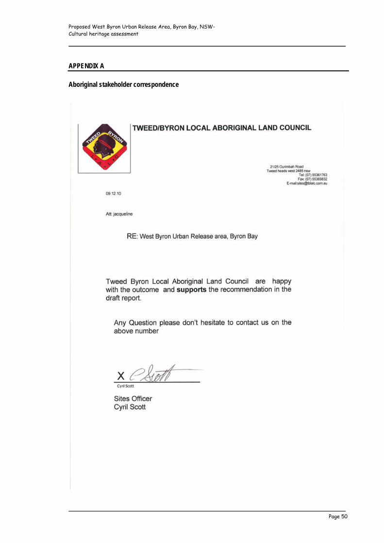
Proposed West Byron Urban Release Area, Byron Bay, NSW- Cultural heritage assessment _____________________________________________________________
_____________________________________________________________ Page 50
APPENDIX A Aboriginal stakeholder correspondence
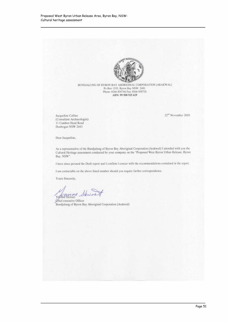
Proposed West Byron Urban Release Area, Byron Bay, NSW- Cultural heritage assessment _____________________________________________________________
_____________________________________________________________ Page 51

Proposed West Byron Urban Release Area, Byron Bay, NSW- Cultural heritage assessment _____________________________________________________________
_____________________________________________________________ Page 52
From: "Lois Cook" <[email protected]> Date: 7 December 2010 2:52:47 PM AEDT To: <[email protected]> Hi Jacky, Thanks for the reminder call last night; the answer is yes I agree with the draft methodology for cultural heritage assessment report and recommendations for Aboriginal Cultural Consultation of the site at West Byron/Belongil Fields, Byron Bay. Yours truly, Lois Cook Cheers