from different spheres to the geodetic observing system · pdf file1750‐1850 arc...
TRANSCRIPT
From different spheres to the Global Geodetic Observing System
Hermann DrewesInternational Association of Geodesy (IAG)
‐ Secretary General ‐Deutsches Geodätisches ForschungsinstitutTechnische Universität München (DGFI‐TUM)
U9 “Revolutions in Earth Sciences: from Different Spheres to a Common Globe”
26th IUGG General Assembly, Prague, June 22 – July 2, 2015
Technische UniversitätMünchen
(wikipedia.org)
H. Drewes: From different spheres to the GGOS, IUGG General Assembly 2015
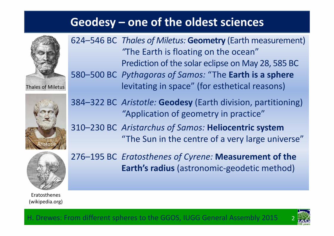
Geodesy – one of the oldest sciences
Ptolemy
Thales of Miletus
2
384–322 BC Aristotle: Geodesy (Earth division, partitioning)“Application of geometry in practice”
310–230 BC Aristarchus of Samos: Heliocentric system“The Sun in the centre of a very large universe”
Aristotle
(wikipedia.org)
624–546 BC Thales of Miletus: Geometry (Earth measurement)“The Earth is floating on the ocean”Prediction of the solar eclipse on May 28, 585 BC
580–500 BC Pythagoras of Samos: “The Earth is a spherelevitating in space” (for esthetical reasons)
276–195 BC Eratosthenes of Cyrene: Measurement of theEarth’s radius (astronomic‐geodetic method)
Eratosthenes (wikipedia.org)

N
R
Equator
H. Drewes: From different spheres to the GGOS, IUGG General Assembly 2015
Astronomic‐geodetic method of Eratosthenes: At summer solstices (June 21) the sun is mirrored in a well in Syene (latitude = 23.4° N, today’s Aswan High Dam), but in Alexandria ( = 31.1° N) the sun is casting a shadow with a length corresponding to an angle ∆ = 7.7°.
Measurement of the distance Alexandria ‐ Syene (the arc length A) by footsteps (Arno Schmidt: Enthymesis or W.I.E.H., 1949) or camel speed.
3
R = A /
A
The angle of the shadow is identical with the latitude difference Alexandria‐Syene:
Determination of the Earth’s radius

4H. Drewes: From different spheres to the GGOS, IUGG General Assembly 2015
Geodesy – one of the oldest sciences
624–546 BC Thales of Miletus: Geometry (Earth measurement)“The Earth is floating on the ocean”
580–500 BC Pythagoras of Samos: The Earth is a spherelevitating in space (for esthetical reasons)
Ptolemy
100–160 AD Claudius Ptolemy: Geocentric coordinatesof ~1000 stars and ~8000 locations on Earth
This system is valid until the end of the Middle Ages.
384–322 BC Aristotle: Geodesy (Earth division, partitioning)“Application of geometry in practice”
310–230 BC Aristarchus of Samos: Heliocentric system“The Sun in the centre of a very large universe”
276–195 BC Eratosthenes of Cyrene: Measurement of theEarth’s radius (astronomic‐geodetic method)
(wikipedia.org)
4
Aristarchus' figure of the relative sizes of the Sun, Earth and Moon
Pythagoras

Copernicus
1473‐1543 Nicolaus Copernicus: Heliocentric system“De Revolutionibus Orbium Coelestium Libri VI“
1564‐1642 Galileo Galilei: “Father of modern physics”1571‐1630 Johannes Kepler: Laws of planetary motions
→ Begin of modern natural sciences
1677‐1756 Jacques Cassini: Arc measurement at Paris: Triangulation and astronomic observations→ Extension of the Earth axis towards the poles
Geodesy at the beginning of modern times
H. Drewes: From different spheres to the GGOS, IUGG General Assembly 2015 5
1643‐1727 Isaac Newton: The Earth is not a sphere but it is flattened at the poles because of its rotation!“Philosophiae naturalis principia mathematica”
Newton
(wikipedia.org)
1580‐1626 Willebrord Snellius: Development of positioning by triangulation networks (with at least 1 distance)→ Begin of systematic geodetic survey

Mpole
Mequator
Determination of the Earth’s flattening
H. Drewes: From different spheres to the GGOS, IUGG General Assembly 2015
Principle: For a flattened Earth the arc of meridian is longer at the poles than at the equator (e.g. a latitude difference of 1° (~ 111 km) is 1120 m longer at the poles than at the equator)
“Arc measurement”:Perform triangulations in north‐south direction close to the pole and close to the equator to determine the arc length of the meridian (arc), and astronomic observations at the end points of the triangulations to determine the latitude difference Δ. Compute then the radii of curvature Mequator and Mpole.
arce
arcp
ΔP
ΔE
6
Mpole = Mequator + 64155 m

18th century: Expeditions to North Pole and Equator
H. Drewes: From different spheres to the GGOS, IUGG General Assembly 2015
←Lapland (wikimedia.org)
Paris Academy 1735‐44:Determination of the Earth’s flattening by arc measurements in Lapland(led by Maupertuis) and
7
Maupertuis
Ecuador (robertwhitaker.org) →
BouguerLa Condamine
in Peru, today Ecuador (led by La Condamine, Bouguer, Godin)
L. Godin

1750‐1850 Arc measurements in Europe (Cassini III und IV,Gauß & Schumacher, Struve, ...) demonstratevariable curvatures in different regions.
1784‐1846 Friedrich Wilhelm Bessel computes a best fittingellipsoid from those measurements (1841)
19th century: Extended arc measurements
Bessel
Baeyer
1794‐1885 Johann Jacob Baeyer: “Conceptual design of aCentral European Arc Measurement“
1861 Memorandum to all Central European countries1862 Counselling of Prussia, Saxony, and Austria1864 First “General Conference“ (Berlin, 14 countries)1867 Extension to Europa (European Arc Measurement)1886 Extension to “International Arc Measurement“Baeyer
H. Drewes: From different spheres to the GGOS, IUGG General Assembly 2015 8
1777‐1855 Carl Friedrich Gauß: “The true figure of Earth is given by the ocean in calm (1873 Listing: “geoid“)
Gauß

‐ Astronomy provides differences ∆Φ and triangulation the distance s = arc(∆)
‐ As a result one gets the variations of the curvature (deflection of the vertical) ε=Φ‐
∆Φ
∆
s
Central European (International) Arc Measurement
H. Drewes: From different spheres to the GGOS, IUGG General Assembly 2015 9
‐ The astronomical observatories shall be connected by a continental triangulation
The project is important for practice, becausegeodetic instruments refer to the Earth’s gravity field (geoid) by their level tubes, but the coordinates refer to an ellipsoid.

Fundamentals by the International Arc Measurement
1916: The arc measurement convention ended 31stof Dec. and was not renewed due to World War I.1917: Helmert died. The “Neutral States” guaranteed the project survival: R. Gautier, H.G. van Bakhuyzen.Gautier Van Bakhuyzen
H. Drewes: From different spheres to the GGOS, IUGG General Assembly 2015
1864‐1885: Director of the Central Bureau J. J. BaeyerCollect, control, archive and process all measurement data1875: Meter convention for the standard unit of length
→ Bureau Interna onal de Poids et Mesures (BIPM)1883: Greenwich Meridian adopted as reference longitudeBaeyer
Baeyer
1886‐1917: Director of the Central Bureau F. R. Helmert‐ Observation and analysis of latitude variation (polar motion)‐ Basic theory: transformation, reduction, condensation …1899:→ International Latitude Service (ILS)1912: → Bureau International de l’Heure (BIH)Helmert
10

1918: At the end of World War I, representatives of various sciences met in London to establish international scientific unions under a common umbrella organisation.
1919: At a Constitutive Assembly in Brussels, the International Research Council (IRC) was constituted with several Unions, among those the‐ International Union of Geodesy and Geophysics (IUGG) and the‐ International Astronomical Union (IAU)The Unions were divided into sections; one of IUGG’s being Geodesy.
H. Drewes: From different spheres to the GGOS, IUGG General Assembly 2015
1922: At the first IUGG General Assembly, the Section Geodesy was constituted. Its first president was W. Bowie (1922‐1933) followed by F. Vening‐Meinesz (1933‐1945). Novel main research fields concentrated on Earth’s gravity:‐ First gravimeters and isostatic modelling;‐ Sea gravimetry (submarine Nautilus).William Bowie
International Union of Geodesy and Geophysics
11

End of 1945 (IUGG) and in August 1946 (IAG) the new statutes were prepared to be adopted at the General Assembly in Oslo 1948
First important IAG project is the European triangulationnetwork (RETrig):
1947: Order of the US AMS to create a unified net
1950: European Datum 19501951: IAG resolution for a
scientific continuation1987: Final solution (ED87)
with 8047 stations
1946: The IAG after World War II
H. Drewes: From different spheres to the GGOS, IUGG General Assembly 2015 12

Revolution 1957: Begin of the satellite age
H. Drewes: From different spheres to the GGOS, IUGG General Assembly 2015
(Ø 30 m)Wild BC4chamber
13
Sputnik 1:1957‐10‐04Explorer 1:1958‐02‐01Echo‐1: 1960‐08‐12

The 1960s: Satellite triangulation
H. Drewes: From different spheres to the GGOS, IUGG General Assembly 2015
45 Stations: accuracy ≈ ± 2...8 m (Schmid 1974)
14

H. Drewes: From different spheres to the GGOS, IUGG General Assembly 2015
29 stations with precisions at the cm‐level (Christodoulidis et al. 1984)
15
..
... . .
..
.
The 1970s: Laser ranging to satellitesRevolution:Mechanic distance measurement replaced by travel times
..
. .QUINCYOWENS VALLEYPASADENAOTAY MT.
GOLDSTONE
BEAR LAKEVERNAL
PLATTEVILLE
FLAGSTAFFMT. HOPKINS
FT. DAVIS AUSTIN
WESTFORD
GREENBELT
PATRICK AFBMON. PK. ..
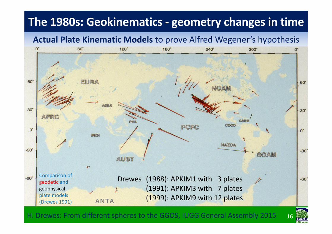
The 1980s: Geokinematics ‐ geometry changes in time
H. Drewes: From different spheres to the GGOS, IUGG General Assembly 2015
Drewes (1988): APKIM1 with 3 plates(1991): APKIM3 with 7 plates(1999): APKIM9 with 12 plates
16
Actual Plate Kinematic Models to prove Alfred Wegener’s hypothesis
Comparison of geodetic andgeophysicalplate models(Drewes 1991) ANTA

The 1990s: Extension of IAG’s International Services
H. Drewes: From different spheres to the GGOS, IUGG General Assembly 2015 17
Name (techniques) Year Principal geodetic products (geometry, gravity, combining)BIPM (Weights & measures) 1875 Meter convention, time parameters (leap second etc.)ILS (Latitude) 1899 1962: IPMS: Polar Motion, 1987: IERS: Earth RotationBIH (Longitude, time) 1912 1987: Earth Rotation and Reference Systems (IERS)PSMSL (Mean sea level) 1933 Collect and archive sea level heights at ocean tide gaugesBGI (Gravimetry) 1951 Relative and absolute terrestrial gravity measurementsICET (Earth tides) 1956 Solid Earth tide parameters, analysis softwareISG (Geoid) 1991 Regional geoid modelsIGS (GNSS) 1994 Orbits, clock corrections, station coordinate time seriesILRS (Laser ranging) 1998 Geocentric station coordinate time seriesIDEMS (Dig. elevation models) 1999 Collect and archive digital terrestrial elevation modelsIVS (VLBI) 1999 Earth orientation, rotation, station coordinate time series
IDS (DORIS) 2003 Doppler satellite orbits and station coordinate time series
ICGEM (Global Earth models) 2003 Collect, archive and compare global gravity Earth models
IGFS (Gravity field) 2004 Coordinate gravity field related products (BGI, ISG, ICGEM)
IAS (Satellite altimetry) 2008 Sea surface heights, sea level change, ocean tide models

H. Drewes: From different spheres to the GGOS, IUGG General Assembly 2015 18
Reference frames for geodynamics and global changeIAG’s International Terrestrial Reference Frame (ITRF) provides positionsand its changes in time of about 600 permanently observing stations with mm‐precision: Geodesy is to measure geodynamics and global change.
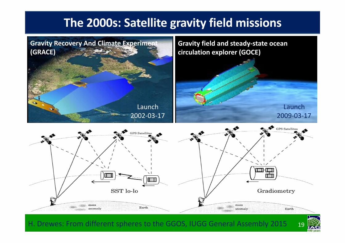
Gravity field and steady‐state ocean circulation explorer (GOCE)
Gravity Recovery And Climate Experiment (GRACE)
H. Drewes: From different spheres to the GGOS, IUGG General Assembly 2015 19
The 2000s: Satellite gravity field missions
Launch2009‐03‐17
Launch2002‐03‐17

GOCE
Oct
Jan
Hydrological mass displacements from gravity changeResults: Seasonal gravity changes generated by hydrological variations
in the watersheds of the main river‐systems
(GRACE_grgs.obs‐mip.fr)
H. Drewes: From different spheres to the GGOS, IUGG General Assembly 2015 20
21
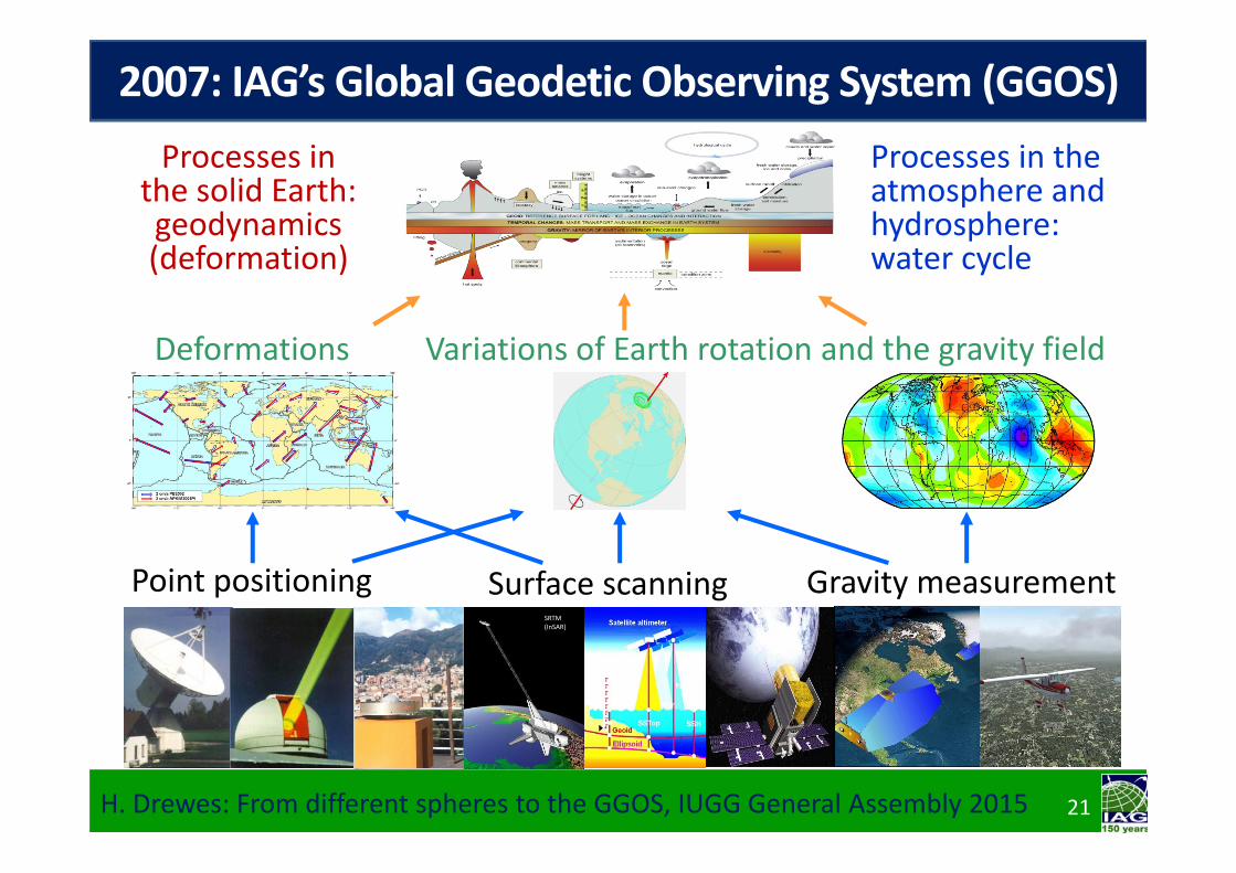
2007: IAG’s Global Geodetic Observing System (GGOS)
H. Drewes: From different spheres to the GGOS, IUGG General Assembly 2015 21
Processes in the atmosphere and hydrosphere: water cycle
Point positioning
Processes in the solid Earth: geodynamics (deformation)
Surface scanning Gravity measurementSRTM(InSAR)
and the gravity fieldVariations of Earth rotationDeformations

Goal: refer height systems to a common equipotential surface all over the world
Today: referring to different tide gauges
GGOS Focus Area 1: Unification of height systems
H. Drewes: From different spheres to the GGOS, IUGG General Assembly 2015 22
Consequences
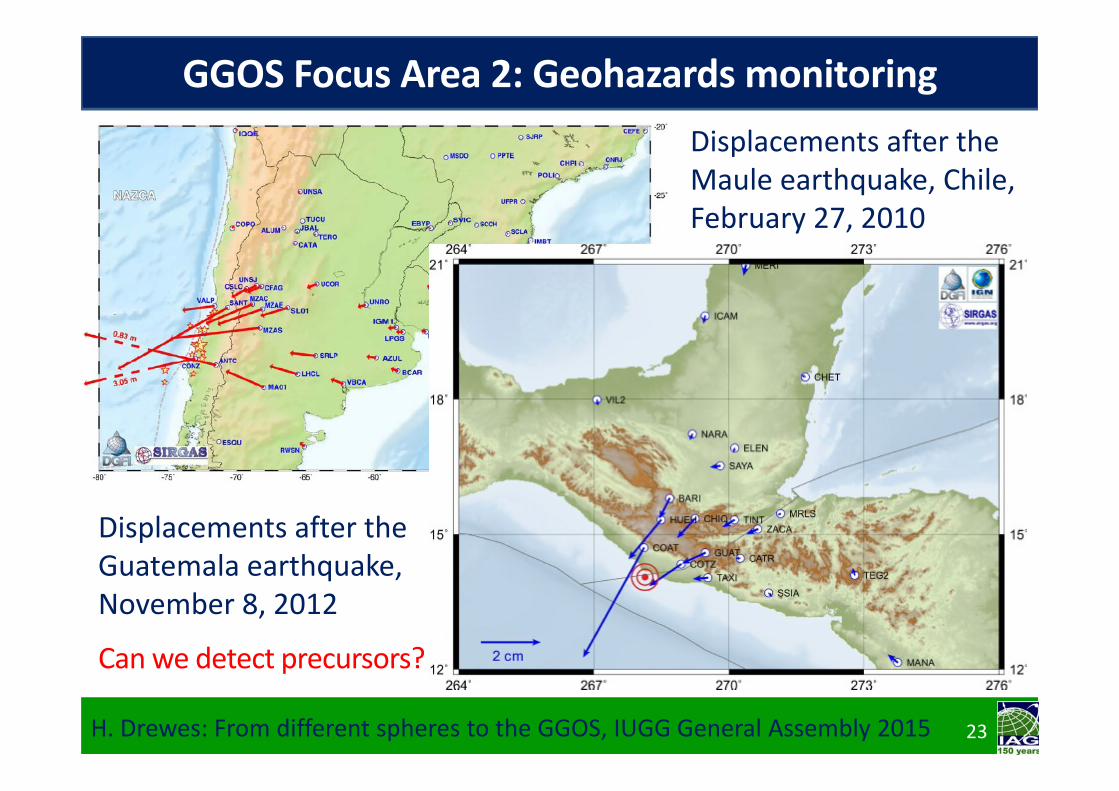
Displacements after the Guatemala earthquake, November 8, 2012
Can we detect precursors?
Displacements after the Maule earthquake, Chile, February 27, 2010
H. Drewes: From different spheres to the GGOS, IUGG General Assembly 2015 23
GGOS Focus Area 2: Geohazards monitoring
H. Drewes: From different spheres to the GGOS, IUGG General Assembly 2015 24
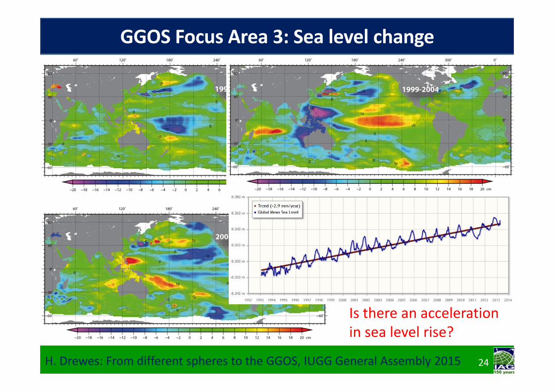
GGOS Focus Area 3: Sea level change
Is there an acceleration in sea level rise?

Geodesy evoluted to the science of measuring the global change, in particular by 3 revolutions:‐ Satellite and space techniques,‐ Precise clocks to measure time,‐ Computers to process the data.
Geodetic techniques observe the components of the System Earth:‐ Solid Earth (deformation, gravity)‐ Atmosphere (signal travel time)‐ Hydrosphere (gravity, altimetry)‐ Cryosphere (laser/ radar scanning)
H. Drewes: From different spheres to the GGOS, IUGG General Assembly 2015 25
Conclusions

Thank you!