fy2010-2011 hfip stream 1 advancements at … hfip stream 1 advancements at ncep/emc vijay...
TRANSCRIPT

1
FY2010-2011 HFIP Stream 1
Advancements at NCEP/EMC
Vijay Tallapragada, Bill Lapenta, John Ward,
John Derber, Hendrik Tolman, Yuejian Zhu,
Stephen Lord, and Many Others at EMC
HFIP Annual Review Meeting, Miami, FL,
November 9, 2010

2
HFIP Stream 1 contributions
Global Modeling
Data Assimilation
Regional Modeling and Physics
Ocean and Wave modeling
Diagnostics and Verification
Ensembles

3
Data Assimilation (17 December 2009) Assimilate:
NOAA-19 AMSU-A/B, HIRS, RARS 1b data
NOAA-18 SBUV/2 and OMI
Tropical Storm SLP
Improved use of GPS RO observations
Refractivity forward operator
Better QC procedures Metop/GRAS, GRACE-A and CHAMP, COSMIC
Increased Horizontal Resolution and Physics Upgrade (28 July 2010 Horizontal resolution
T382 (35km) to T574 (~28km) & 64L for 0 to 192hr forecast
Remains T190 (~70km) & 64L for 192-384 hr forecast
Upgrade GFS physics (Radiation, shallow/deep convection and PBL)
Modified SW and LW radiation calculations (aerosol effects, co2, cloud interaction)
Detrainment from all levels (deep convection)
PBL diffusion in inversion layers reduced (decrease erosion of marine stratus)
Includes gravity wave drag (effect of topography)
Upgrades to Global System
4
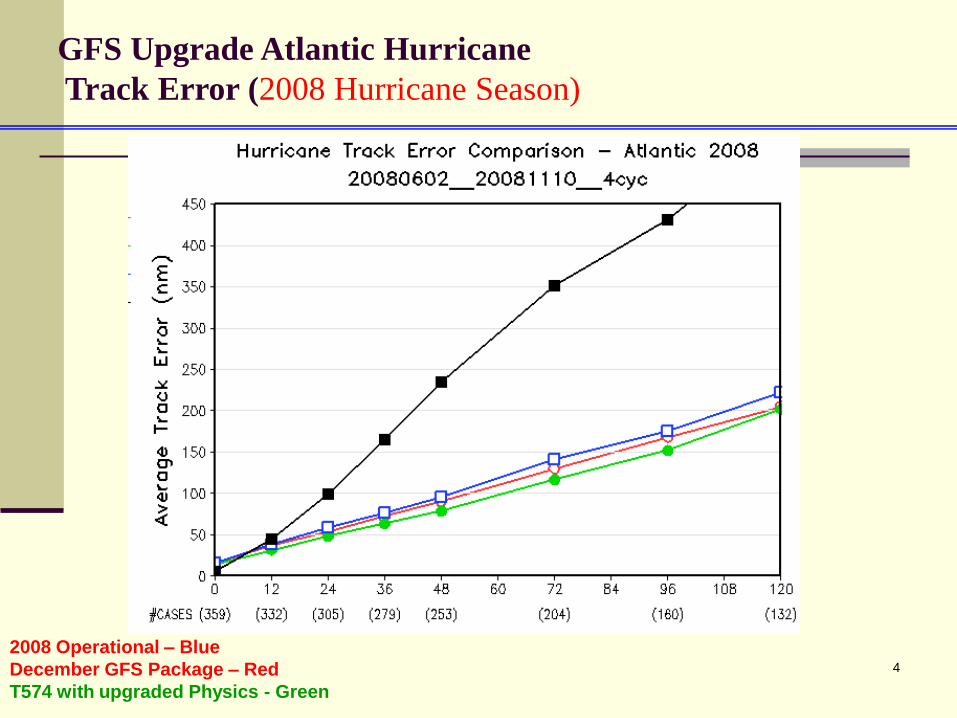
GFS Upgrade Atlantic Hurricane
Track Error (2008 Hurricane Season)
2008 Operational – Blue
December GFS Package – Red
T574 with upgraded Physics - Green
5
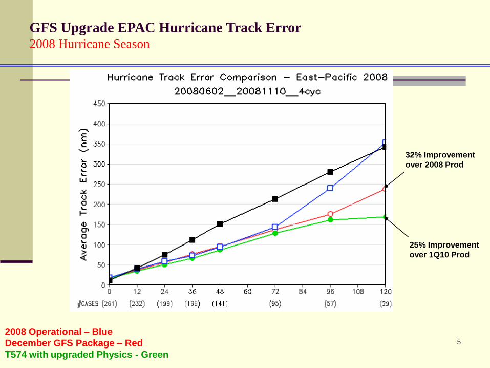
GFS Upgrade EPAC Hurricane Track Error2008 Hurricane Season
32% Improvement
over 2008 Prod
25% Improvement
over 1Q10 Prod
2008 Operational – Blue
December GFS Package – Red
T574 with upgraded Physics - Green
6
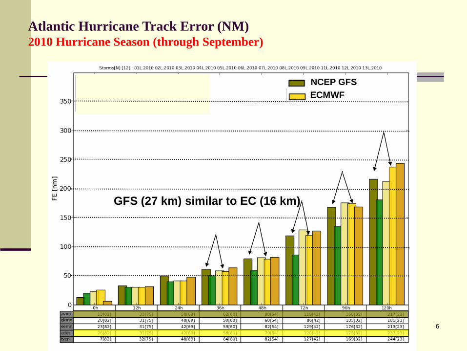
Atlantic Hurricane Track Error (NM)2010 Hurricane Season (through September)
NCEP GFS
ECMWF
GFS (27 km) similar to EC (16 km)
7
Planned Global Data Assimilation
System Upgrade (FY11)
Joint Development with JCSDA, NASA, ESRL
New Observations
ASCAT winds
Radar and Lightning data IO and cloud analysis for RR (GSD, DTC)
NOAA-19 SBUV/2
NOAA-19 MHS – remove NOAA-15 AMSU-BQC and data handling
QC and Data Handling
Upgrade quality control of MHS/AMSU-B water vapor channels
Improve location of Buoys in vertical (move from 20 to 10m)
Improved OMI QC
Removal of redundant SBUV/2 total ozone
Retune SBUV/2 ozone ob errors
Relax AMSU-A Channel 5 QC
Remove down weighting of collocated radiances
8
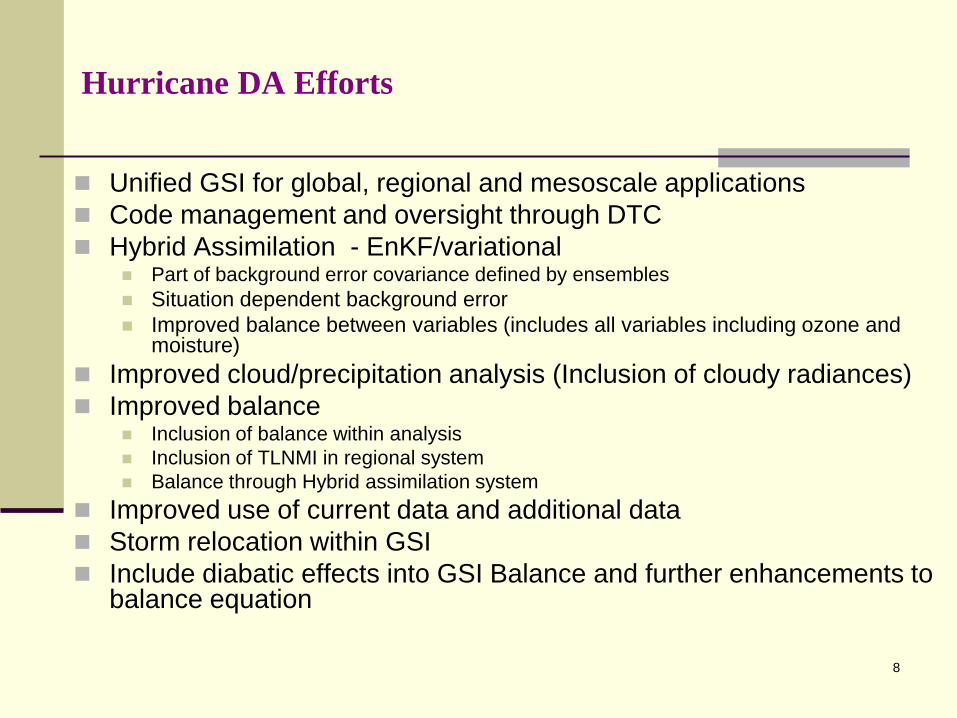
Hurricane DA Efforts
Unified GSI for global, regional and mesoscale applications
Code management and oversight through DTC
Hybrid Assimilation - EnKF/variational Part of background error covariance defined by ensembles
Situation dependent background error
Improved balance between variables (includes all variables including ozone and moisture)
Improved cloud/precipitation analysis (Inclusion of cloudy radiances)
Improved balance Inclusion of balance within analysis
Inclusion of TLNMI in regional system
Balance through Hybrid assimilation system
Improved use of current data and additional data
Storm relocation within GSI
Include diabatic effects into GSI Balance and further enhancements to balance equation

9
Regional Modeling Efforts
See next presentation on HWRF
model development efforts
10
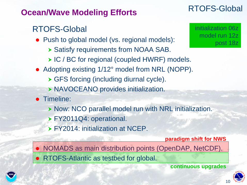
continuous upgrades
RTOFS-Global
RTOFS-Global
Push to global model (vs. regional models):
Satisfy requirements from NOAA SAB.
IC / BC for regional (coupled HWRF) models.
Adopting existing 1/12° model from NRL (NOPP).
GFS forcing (including diurnal cycle).
NAVOCEANO provides initialization.
Timeline:
Now: NCO parallel model run with NRL initialization.
FY2011Q4: operational.
FY2014: initialization at NCEP.
NOMADS as main distribution points (OpenDAP, NetCDF).
RTOFS-Atlantic as testbed for global.
initialization 06z
model run 12z
post 18z
paradigm shift for NWS
Ocean/Wave Modeling Efforts
11
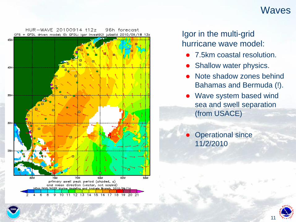
Waves
Igor in the multi-grid
hurricane wave model:
7.5km coastal resolution.
Shallow water physics.
Note shadow zones behind
Bahamas and Bermuda (!).
Wave system based wind
sea and swell separation
(from USACE)
Operational since
11/2/2010

12
Waves
Present capability illustrated with test runs for
hurricane Gustav.
Grid resolution up to 400m, working on 100m grids.
Dynamic inundation using ADCIRC water levels.
Joint project with NGI through MSU and LSU
13
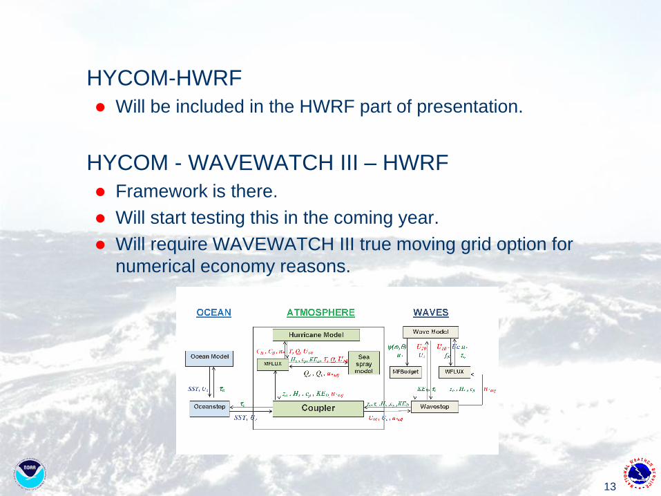
HYCOM-HWRF
Will be included in the HWRF part of presentation.
HYCOM - WAVEWATCH III – HWRF
Framework is there.
Will start testing this in the coming year.
Will require WAVEWATCH III true moving grid option for
numerical economy reasons.
14
Enhanced HWRF Diagnostics and Verification
• Operational HWRF Statistics Website
• Modified Statistical Verification
• HWRF Simulated-GOES Images
• Unified Post Processing
Contributions to ADD and Verification Teams
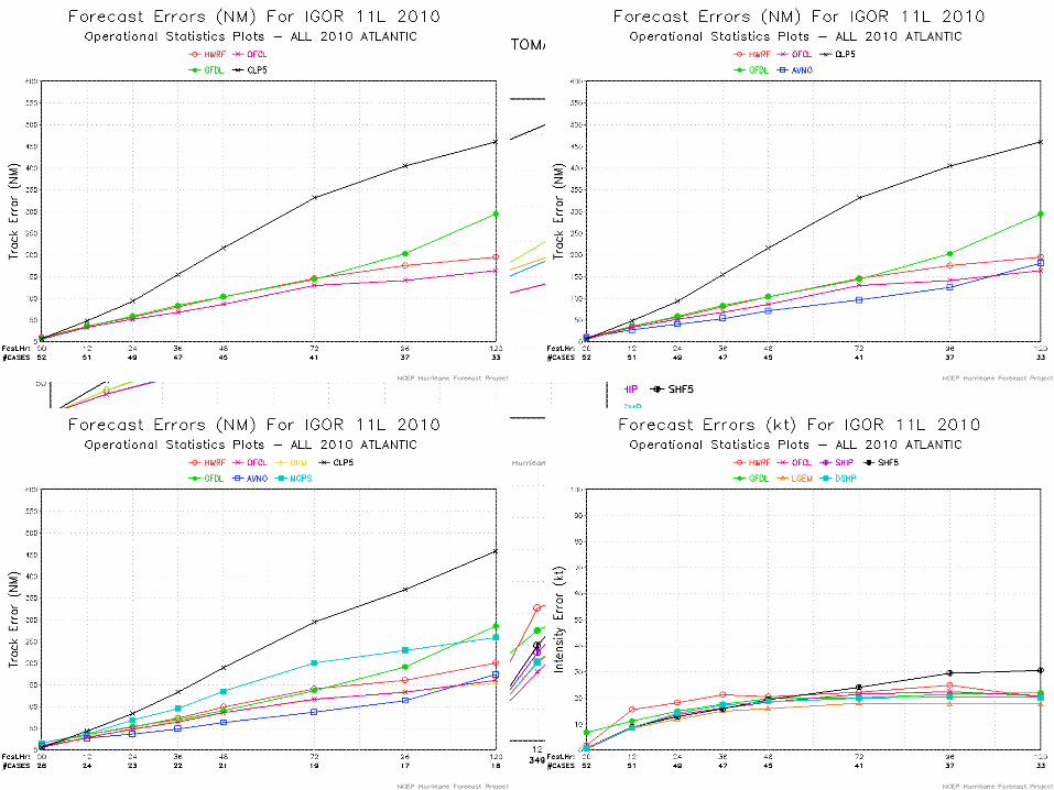
15
Operational HWRF Statistics Page• New Plots Generated Every 6 hours when HWRF is run• Individual and All-Season Stats Available
16
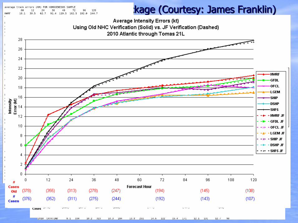
New NHC Verification Package (Courtesy: James Franklin)
• More advanced version of nhcver.x compared to what currently using• Ability to look at along track and cross track errors• Ability to look at land vs. water points• Format of textfile output different than previous verification package
– Need different method of visualization– Old vs. New Version very similar
17
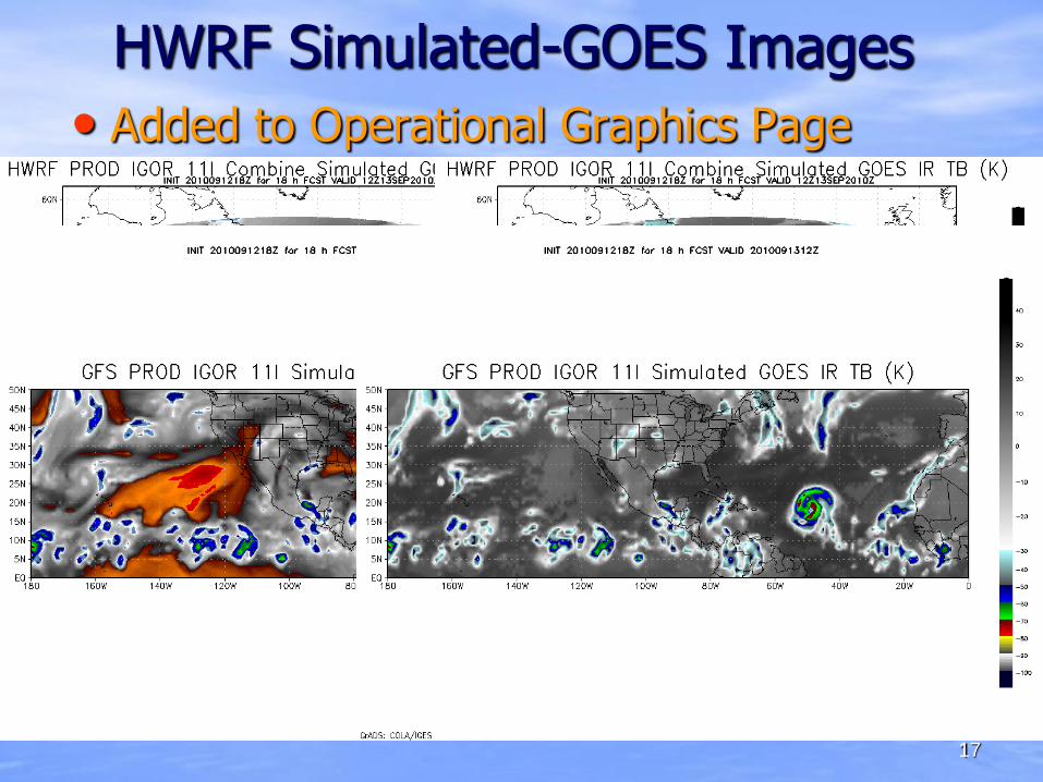
HWRF Simulated-GOES Images
• Added to Operational Graphics Page
• Available for 2010 Hurricane Season
• Include Simulated GOES images for GFS on HWRF webpage
18
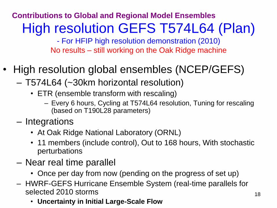
High resolution GEFS T574L64 (Plan)- For HFIP high resolution demonstration (2010)
No results – still working on the Oak Ridge machine
• High resolution global ensembles (NCEP/GEFS)– T574L64 (~30km horizontal resolution)
• ETR (ensemble transform with rescaling)
– Every 6 hours, Cycling at T574L64 resolution, Tuning for rescaling (based on T190L28 parameters)
– Integrations• At Oak Ridge National Laboratory (ORNL)
• 11 members (include control), Out to 168 hours, With stochastic perturbations
– Near real time parallel• Once per day from now (pending on the progress of set up)
– HWRF-GEFS Hurricane Ensemble System (real-time parallels for selected 2010 storms
• Uncertainty in Initial Large-Scale Flow
Contributions to Global and Regional Model Ensembles
19
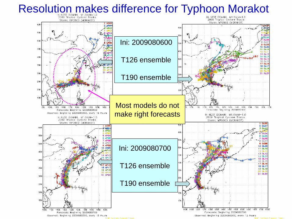
Resolution makes difference for Typhoon Morakot
Ini: 2009080600
T126 ensemble
T190 ensemble
Ini: 2009080700
T126 ensemble
T190 ensemble
Most models do not
make right forecasts
20
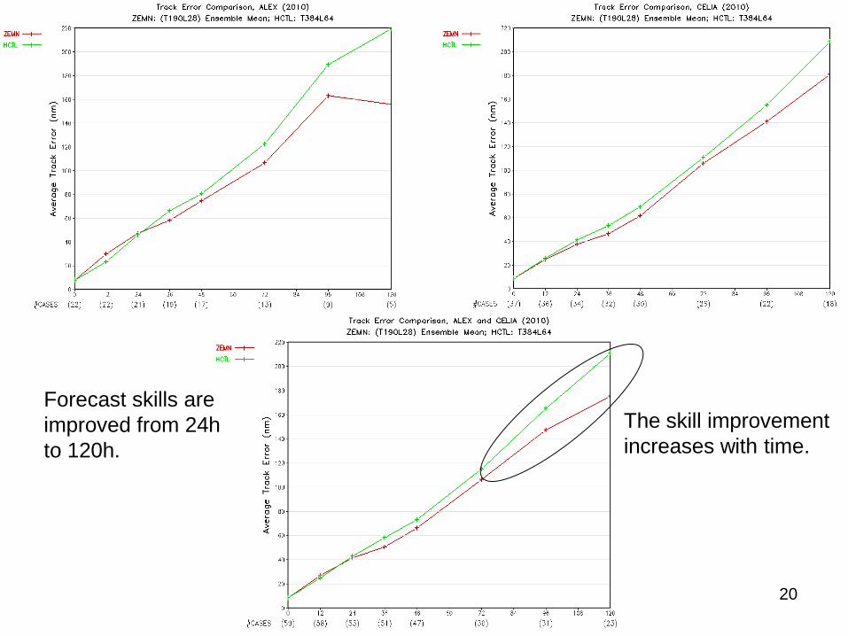
Forecast skills are
improved from 24h
to 120h.
The skill improvement
increases with time.

21
0
50
100
150
200
250
300
350
400
0 12 24 36 48 72 96 120
NCEPraw NCEPbc NAEFS
Cases 240 223 196 169 144 110 75 42
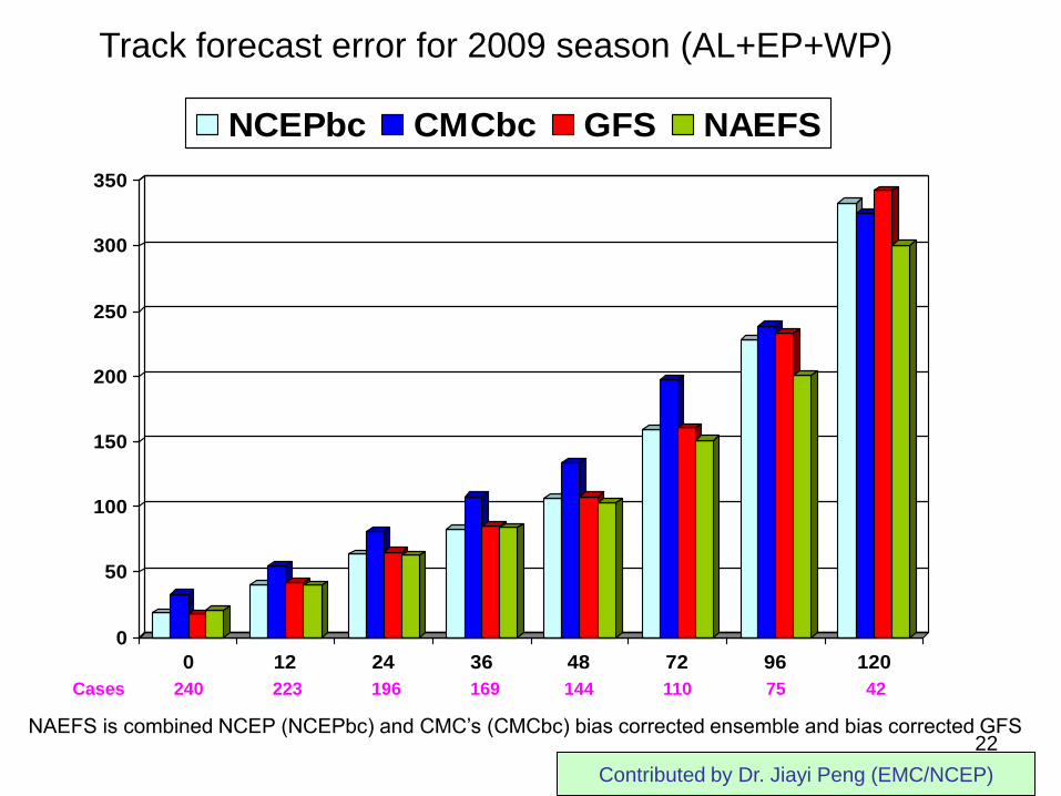
Track forecast error for 2009 season (AL+EP+WP)
NAEFS is combined NCEP (NCEPbc) and CMC’s (CMCbc) bias corrected ensemble and bias corrected GFS
Contributed by Dr. Jiayi Peng (EMC/NCEP)
Ensemble post processing and
multi-model ensembles (NAEFS)
22
0
50
100
150
200
250
300
350
0 12 24 36 48 72 96 120
NCEPbc CMCbc GFS NAEFS
Cases 240 223 196 169 144 110 75 42
Track forecast error for 2009 season (AL+EP+WP)
NAEFS is combined NCEP (NCEPbc) and CMC’s (CMCbc) bias corrected ensemble and bias corrected GFS
Contributed by Dr. Jiayi Peng (EMC/NCEP)
23
More details on EMC contributions
will be presented in individual team
reports by respected team leads
Thanks for your attention