gps free node localization in mobile wireless sensor networks · gps free node localization in...
TRANSCRIPT

GPS Free Node Localization
in Mobile Wireless Sensor
Networks
5th ACM international workshop on Data engineering for wireless 5th ACM international workshop on Data engineering for wireless and mobile access
Year of Publication: 2006
Presented by
Pavneet Singh GillGroup No. 1

Background
Purpose of Localization Schemes
• Optimized or maintained connectivity
• Coordination for node tasks
Localization can require GPSLocalization can require GPS
• GPS signal not always available
• Indoors, GPS unreliable
Fixed Point reference nodes
• Use of beacons
• Static network

Paper Contributions
"The main contribution of this work is that it presents a solution to the problem of directional localization in GPS free sensor networks with mobile nodes."
• Provides directional neighbor localization in a network-wide coordinate system
• Provides directional neighbor localization in a network-wide coordinate system
• Works under fairly large motion and distance measurement errors
• Unaffected by the speed of nodes
• Works for any network size
• Supports a stable network in mobility problems

Localization Algorithm
Assumptions• Each node has a compass pointing North (or any other
common reference direction)
• Nodes can measure the distance to their neighbors using a well known range measurement method (e.g. Time of Arrival (TOA))Time of Arrival (TOA))
• Motion actuators allow each node to move a specific distance in a specific direction.
• Actuator, compass and distance measurements are subject to errors caused by various real world disturbances
• Other than the above, no additional positioning equipment or infrastructure is required.

Localization Algorithm
The core localization algorithm works on well
defined rounds. Each round essentially consists
of three steps:
1. Measure distances between neighbors
2. Move nodes
3. Exchange distance values for that round as
validation for movement

Localization Algorithm
Core Localization Algorithm

Localization Algorithm

Localization Algorithm
Verification Algorithm

Simulation Results
Ideal Conditions• Placed nodes in a 100x100
area
• Each simulation is run for
100 rounds100 rounds
• Random walk, random
speed
• As small as 3% maximum
failure for very sparse
networks

Simulation Results
Including Measurement
Errors
• Same as previous
experiment
• Distance noise as a • Distance noise as a
percent of measured
value
• Angle noise as a static %
of 2 pi

Simulation Result
Comparison with an absolute positioning algorithm
• Units are placed with initially perfect data and record their own movement from there
• Performed random movement and directed movement experiments
• 2000 rounds, averaged error at 6 places• 2000 rounds, averaged error at 6 places

Simulation Results

Strength And Weakness
• Strengths:
– Localization without the use of GPS.
– Does not require any infrastructure
– Information about relative position.
– Gives error in the range of 3m.
• Weakness:
– Need of compass at each node.
– Cannot give the location information in terms of
coordinates.
– Comparison of algorithm with an absolute positioning
algorithm whose name has not been mentioned.

Paper Significance to Project
• Useful for relative localization of nodes.
• Can be used at instance as no infrastructure is
required.required.
• GPS for our project?

Algorithms for Nodes
Localization in Wireless
Ad-Hoc Networks Based on
Cost Function
International Workshop on Wireless Ad- Hoc Networks(IWWAN)
Year of Publication : 2005

Introduction
• Distribute algorithm to localize sensor network nodes.
• Use of UWB for accuracy .• Use of UWB for accuracy .
• Based on capacity of nodes to calculate Time of arrival(TOA) and Angle of Arrival(AOA).

Algorithm
1. Determine Node beacon distances
2. Compute the cost function of every node.
3. Compute the coordinate of the node using Davidson-Fletcher-Powell Quasi Newton algorithm (DFP) or Direct Method(DM) algorithm.
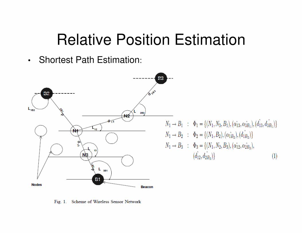
Relative Position Estimation• Shortest Path Estimation:

Relative Position Estimation
• Position Estimation:
Cost Function α estimated angle,
distance between nodes,
no. of beacons,no. of beacons,
no. of hops between a node
and the given beacon

Positioning Algorithm
• Davidson-Fletcher-Powell Quasi Newton algorithm (DFP):
– Gives position vector using the following
equation:equation:

Positioning Algorithm
• Direct Method:

Simulation Results
• Results show that algorithm is more sensitive to TOA than to AOA.

Simulation Results

Simulation Results
• DFP is positionally more accurate than DM

Strengths and Weakness
• Strengths:
– Gives exact position along with coordinates of
node with error of about 1.3 meters.
– Distributed algorithm.– Distributed algorithm.
– No use of GPS and use of UWB.
– No extra devices or instruments needed on
the node.

Strengths and Weakness
• Weakness:
– Algorithm not compared with other existing
algorithms.
– Need of beacons along with their coordinates – Need of beacons along with their coordinates
to estimate the position of nodes.
– Depends upon the density of beacons for
accuracy.

Paper Significance to the
Project• Doesn’t rely on GPS
• Useful in determining the location with exact coordinates.exact coordinates.